American Oystercatchers in Jamaica Bay. - New York … Oystercatchers in Jamaica Bay. 72 RESTORE THE...
12
American Oystercatchers in Jamaica Bay. Don Riepe RESTORE THE NATURAL WATERFRONT 72
Transcript of American Oystercatchers in Jamaica Bay. - New York … Oystercatchers in Jamaica Bay. 72 RESTORE THE...

American Oystercatchers in Jamaica Bay.
Don
Rie
peRESTORE THE NATURAL WATERFRONT72
73VISION 2020: NEW YORK CITY COMPREHENSIVE WATERFRONT PLAN
Restore degraded natural waterfront areas, and protect wetlands and shorefront habitats.
GOAL 5
VISION 2020: NEW YORK CITY COMPREHENSIVE WATERFRONT PLAN 73
Don
Rie
pe

RESTORE THE NATURAL WATERFRONT74
SPECIAL PROTECTIONS FOR NATURAL AREAS
New York City today is a largely man-made environment of buildings, streets, and side-walks. But it’s also situated at the center of an important estuary. The Hudson-Raritan Estu-ary, which the U.S. Congress has recognized as an estuary of national significance, encompasses complex and diverse habitat assemblages that thrive at the interface of saltwater and fresh-water. Ecosystems within the estuary provide stopover points for migratory birds and homes for creatures ranging from oysters to fiddler crabs.
Much of the city’s natural waterfront con-sists of wetlands, the biologically rich area where water and land meet. Wetlands are for-aging and breeding sites for shorebirds, fish, and invertebrates. They act as natural filtration sys-tems, retaining stormwater runoff and trapping pollutants that would otherwise contaminate waterways. And they mitigate storm surges by absorbing the impact of waves. Other parts of the natural waterfront—beaches, bluffs and dunes—provide habitat for shorebirds and na-tive plants and help protect buildings and infra-structure from wave action. Submerged lands in shallows and open water are also important foraging and breeding grounds for marine and avian species. All these landscapes are valuable assets, advancing biodiversity and performing services vital to New York City.
But many natural areas are in jeopardy. Wetland and associated habitat loss is a serious threat across the Estuary as a result of landfill, rising sea levels, introduction of non-native spe-cies, as well as altered sediment transport and tributary flow. Estimates of total tidal wetland loss range from 83 to 86 percent. Only 14 of the original 86 to 100 square miles of wetlands remain.
To improve degraded areas and create new
habitat, an active approach to managing ecologi-cal functions and values is necessary. The City must not only protect natural resources; it must actively restore them.
Significant restoration projects have been under way in New York City for some time. Restoration methods for some impaired wa-terfront ecosystems, including many types of tidal marsh, are well established and are being implemented on a large scale. Other types of restoration strategies need additional pilot stud-ies, monitoring, and evaluation as the science and practice of ecological restoration evolves.
includes an assessment of the project’s poten-tial impact on the SNWA. However, despite the SNWA program, and despite extensive restoration projects since 1992, the health of these natural areas is still in the balance. Active management and intervention is necessary to help these areas flourish as diverse and healthy ecosystems.
The mapping of the SNWAs was largely based on the New York State Department of State Significant Coastal Fish and Wildlife Habi-tats, a designation indicating that a given area plays an important role in the lifecycle of wild-life species. There are 15 designated areas in New York City containing significant coastal fish and wildlife habitat. A project within a Significant Coastal Fish and Wildlife Habitat requires an as-sessment of its impacts on habitat.
The Coastal Erosion Hazard Areas program of the New York State Department of Environ-mental Conservation maps shoreline stretches susceptible to erosion. Waterbodies can cause erosion of the coastline through wave action, currents, tides, and wind-driven water and ice; construction and shipping activities can also be factors. Erosion can result in extensive damage to publicly and privately owned property and to natural resources, and it can also endanger lives. Developments within the Coastal Erosion Hazard Areas are required to obtain permits to make certain that the projects are undertaken in ways that minimize property damage and prevent the exacerbation of erosion hazards.
Status of the Jamaica Bay SNWALocated in Brooklyn and Queens, Jamaica Bay is one of the most productive ecosystems in the northeastern United States and contains the largest tidal wetland complex in the New York metropolitan area. The Jamaica Bay SNWA, which covers all of the Bay, encompasses coastal woodlands, maritime shrublands, grass-lands, freshwater wetlands, brackish marsh, salt marsh, and open water. A little over half of the Bay is in the Jamaica Bay unit of Gateway National Recreation Area, which includes the Jamaica Bay Wildlife Refuge—the only national wildlife refuge accessible by subway and bus.
“You look out at the Harbor and you see the flat surface. But just as there is a riot of activity on the streets of Manhattan, there’s a swirl of activity beneath the surface of the water—from giant sturgeon all the way down to the tiniest little creatures that form the base of the food chain.”—Clay Hiles, Executive Director, Hudson River Foundation
RESTORE THE NATURAL WATERFRONT GOAL 5
In New York City, there are three main regu-latory programs that target the protection of natural areas: the Special Natural Waterfront Areas, the Significant Coastal Fish and Wildlife Habitats, and the Coastal Erosion Hazard Ar-eas (see Figure 1, page 75). These programs protect natural resources within specified areas (which in some cases overlap) primarily through enhanced review of projects proposed in these areas.
The three Special Natural Waterfront Areas (SNWAs) are large areas of complex waterfront habitats and natural resources, established as a result of recommendations in the 1992 Com-prehensive Waterfront Plan. The City designat-ed and mapped the Jamaica Bay SNWA, the Northwest Staten Island SNWA, and the Upper East River-Long Island Sound SNWA as part of the Waterfront Revitalization Program, seeking to counteract fragmentation and loss of habitat through environmental protection and ecologi-cal restoration. When a project in the coastal zone requires a discretionary permit, the review

75
[2.50 5
[2.50 5
[2.50 5
Special Natural Waterfront Areas
Significant Coastal Fish and Wildlife Habitats
Coastal Erosion Hazard Areas
ATLANTIC OCEAN
LONGISLAND SOUND
EAST RIVER
KILL VAN KULL
ARTH
UR
KILL
LOWER NEW YORK
BAY
UPPERNEW YORK
BAY
HUDSON R
IVER
BROOKLYN
STATEN ISLAND
QUEENS
THE BRONX
MANHAT
TAN
Figure 1: Special Natural Waterfront Areas, Significant Coastal Fish and Wildlife Habitats, and Coastal Erosion Hazard Areas.
The Bay is an important habitat for wildlife, with more than 100 species of fish, a number of endangered species (including the peregrine falcon, piping plover, and the Atlantic Ridley sea turtle), and 214 “species of special concern.” More than 325 species of birds have been sighted in the Bay, which serves as an important stopover point on the Atlantic Flyway migration route for nearly 20 percent of the birds on the continent.
One of the most serious issues facing Ja-maica Bay is the rapidly accelerating rate of marsh fragmentation and loss. The rapid de-cline of Jamaica Bay’s iconic marsh islands can be attributed to many factors. Hardening of the coastline, pollution, alterations due to dredging, sediment deprivation, tidal changes, sea level rise, and the loss of freshwater tributaries have all contributed to wetland degradation over the past 150 years, with marshland loss accelerating in the last 20 years.
The City and other partners are investing millions of dollars in actively restoring the wet-
lands of Jamaica Bay. Habitat restoration in and along Jamaica Bay has been part of a compre-hensive strategy by the Department of Envi-ronmental Protection (DEP) to improve water quality while creating productive ecological ar-eas (as put forth in the Jamaica Bay Watershed Protection Plan). DEP infrastructure improve-ment projects have incorporated restoration. The ecological restoration of Paerdegat Basin is part of DEP’s current efforts to treat and capture combined sewer overflows to improve water quality within the basin. This project entails the restoration of tidal wetlands and indigenous coastal vegetation and the construction of an Ecology Park. The Ecology Park will provide ac-cess to salt marsh, intertidal mudflats, grassland, and shrublands, and it will also offer educational exhibits about coastal habitats.
In addition, DEP has led several restoration projects on the perimeter of Jamaica Bay, includ-ing the closure and remediation of the Penn-sylvania Avenue and Fountain Avenue landfills. These inactive hazardous waste sites are being
transformed into safe, productive, and usable open space. DEP’s ecological restoration plan for these properties is consistent with and will enhance the existing natural features of Jamaica Bay. This project, which involves the planting of 30,000 trees and shrubs and more than 400 acres of coastal grasslands, is the largest resto-ration of its type in the city. The former landfills will provide significant habitat improvements for the Bay and in time will become regional seed sources to disseminate plant species to other parts of the New York metropolitan area. In addition, the end-use design plan, developed with input from local community groups, may include opportunities for public access.
Status of the Northwest Staten Island SNWAThe northwest shore of Staten Island is a di-verse landscape of habitat assemblages in-terspersed with industrial areas. Because this SNWA is adjacent to the Kill Van Kull Significant Maritime Industrial Area, it poses tough chal-lenges that require creative solutions.
The Northwest Staten Island SNWA is bounded by the Kill Van Kull and Newark Bay to the north, the Arthur Kill to the west, resi-dential zones to the east, and Fresh Kills to the south. This area may boast the most diverse array of wetland types in the city, including salt and freshwater meadows, spring-fed ponds, forested swamps, creeks, and salt marshes. Wooded upland areas abut tidal complexes, supporting avian species, amphibians, reptiles, and mammals.
Northwest Staten Island became known as the Harbor Heron’s Complex in the 1990s when shorebird populations peaked in the area. “Harbor Herons” was a blanket term given to a group of avian species that captured public at-tention including the great egret, snowy egret, black-crowned night heron, and glossy ibis. After virtually disappearing from the New York Harbor area, these shorebirds began to appear again with the improvement in water quality brought about by the Clean Water Act. Three islands in the SNWA were prime nesting sites: Shooter’s Island, Prall’s Island, and the Isle of Meadows. However, in recent years, Harbor Herons have abandoned the three islands, ac-cording to monitoring by the New York City Audubon Society in cooperation with the De-partment of Parks & Recreation (DPR). Defor-estation on Prall’s Island, due to infestation by the invasive Asian longhorned tree beetle, have
NYC
Dep
artm
ent o
f City
Pla
nnin
g, N
YS D
epar
tmen
t of S
tate
, NYS
Dep
artm
ent o
f Env
ironm
enta
l Con
serv
atio
n
JAMAICABAY
VISION 2020: NEW YORK CITY COMPREHENSIVE WATERFRONT PLAN

RESTORE THE NATURAL WATERFRONT76
compromised this island as a nesting site. Despite the decline of Harbor Herons in
Northwest Staten Island, other vibrant avian populations still occupy this SNWA. Nearby wooded areas and swamps with tidal and fresh-water wetlands are prime foraging sites for shorebirds. Surveys by DPR have shown Gran-iteville Swamp to be a resting site for migrating songbirds, and more than 100 bird species have been observed nesting or feeding in Arling-ton Marsh, though large portions of Arlington Marsh were contaminated by industry and the ecosystem is highly disturbed.
Fresh Kills was originally the largest tidal wetland complex in the region. However, this site became the Fresh Kills Landfill in the early 1950s. At the time of its closure in 2001, Fresh Kills was the biggest municipal landfill in the world—four mounds of refuse occupy-ing 2,200 acres. The City is transforming the former landfill site into Freshkills Park. The first portion of the park will open in 2011, with full build-out occurring in phases over the next 30 years. The park is being designed to include natural corridors that connect to the Staten Island Greenbelt. Stormwater drainage basins within the site have already begun to take on the characteristics of freshwater wetlands.
Bordering the northeast edge of Freshkills Park, William T. Davis Wildlife Refuge is a diverse tidal wetland complex spanning 260 acres. It contains salt meadow, low marsh, swamp for-
est, and spring-fed ponds. More than 117 bird species have been observed on this site.
Status of the Upper East River-Long Island Sound SNWAThis SNWA encompasses parts of the north shore of Queens and the southeastern shore of the Bronx, along the Upper East River and Long Island Sound. Pockets of salt marsh along inlets, coves, and islands dot a rocky intertidal coast-line. Sections of armored riprap retain hundreds of acres of fill. On the south side of the Sound, in Queens, significant salt marshes exist at Al-ley Pond Park (the site of salt marsh restoration over the past 10 years) and Udalls Cove. Alley Pond Park and Udalls Cove are two of the six Significant Coastal Fish and Wildlife Habitats in this SNWA; Meadow and Willow Lakes, Little Neck Bay, Pelham Bay Park, and North/South Brother Islands are the others. The large ex-panse of freshwater at Willow and Meadow Lakes, the result of extensive landfill on former salt marsh, still has a tidal connection through the permeable tide gates on Flushing Creek.
Thousands of acres of salt marsh, tidal chan-nels, and mud flats once characterized the Bronx shoreline, on the north side of the Upper East River. Most of these areas were filled in by the 1950s. Existing tidal wetlands are concentrated in Pelham Bay Park along Goose Creek Marsh on the Hutchinson River. There are thin fringes of low marsh vegetation at the southern end of
Arlington Marsh on Staten Island.
Soundview Park and Ferry Point Park, and to a greater extent at Castle Hill and Pugsley Creek Parks. Westchester Creek, once also bordered by salt marsh, has almost no remaining tidal vegetation, having been heavily developed for industrial uses. This and other tidal creeks on the south and north sides of the Sound and Upper East River receive combined sewer dis-charges.
The Harbor Heron population on South Brother Island has been steadily increasing. The 2007 Harbor Herons survey by the NYC Audubon Society and institutional partners found that South Brother had the largest num-ber of shorebird nests in the city (592 nests). In contrast, nesting populations have been declin-ing on North Brother Island.
Additional Sites of Ecological ImportanceSince the 1992 Comprehensive Waterfront Plan, the City has come to recognize the ecological importance of sites that are smaller than the Special Natural Waterfront Areas. Data sug-gests that these smaller dispersed sites per-form valuable ecosystem services and provide habitat diversity. Many sites have been acquired as parkland or designated as natural areas, but warrant additional protective measures. Other sites remain in private ownership and should be acquired for conservation or placed under con-servation easements. These sites are in areas such as the Upper Bronx River, the Arverne area of the Rockaways, Plumb Beach, the Southern portion of the Arthur Kill shoreline, portions of the Raritan Bay Shoreline (Conference House Park, Paw Paw Wood, Butler Manor, Mount Loretto-Lemon Creek Park, Wolfe’s Pond Park, Blue Heron Park), the Staten Island Greenbelt, and the Staten Island South Shore Bluebelts. Adding these areas to the Waterfront Revitiliza-tion Program as sites of ecological importance would enhance their protection.
Many City-owned natural areas with habi-tat and ecological value are protected through DPR’s Forever Wild program. DPR has desig-nated 51 areas within the City’s park system as Forever Wild preserves, including many natural waterfront sites. Improvements within a For-ever Wild preserve receive enhanced internal review.

77VISION 2020: NEW YORK CITY COMPREHENSIVE WATERFRONT PLAN
Another shift in thinking over the past 18 years has been an increasing recognition of the im-portance of regional planning for habitat pro-tection and restoration. Municipal and state boundaries, of course, have no impact on the flow of water and the movement of species. Ecosystem protection and restoration benefit from regional cooperation and coordination.
There has been great momentum behind regional planning for the Hudson-Raritan Estu-ary. After the Estuary was recognized by Con-gress as an estuary of national importance in 1988, representatives from federal, state, and city governments and local civic organizations convened with the goal of improving the en-vironmental quality of the Estuary. They set up the Harbor Estuary Program (HEP) to coordi-nate restoration activities in the region. Under the aegis of the HEP, the U.S. Army Corps of Engineers and the Port Authority of New York & New Jersey produced the draft Hudson-Raritan Estuary Comprehensive Restoration Plan (CRP), a master plan for ecosystem restoration intended for use by all stakeholders.
The CRP identifies four principles: the Estu-ary is human-dominated, has been irreversibly changed, will continue to change, but can be al-tered beneficially through wise implementation of science and technology. The CRP also iden-tifies 11 measurable restoration objectives, or Target Ecosystem Characteristics (TECs): coast-al wetlands; islands for waterbirds; coastal and maritime forests; oyster reefs; eelgrass beds; shorelines and shallows; habitat for fish, crabs, and lobsters; tributary connections; enclosed and confined waters; sediment contamination; and public access. For each TEC, quantifiable long- and short-term objectives are described and opportunity areas identified.
The CRP provides a useful Estuary-wide context for planning restoration and enhance-ment projects in New York City. Though many restoration projects in the city began prior to the drafting of the CRP, they advance the goals of the CRP. And future restoration projects planned by the City will further the objectives of the CRP. Implementing natural resource policies for the New York City waterfront in an Estuary-wide context offers the potential for enhanced synergy and coordination among project pro-ponents, land managers, and funding agencies.
HUDSON-RARITAN ESTUARY PLANNING
ECOLOGICAL RESTORATION PROJECTS
The City’s efforts to restore the ecological health of New York’s waterways and waterfront have benefited from advances in the science and practice of ecological restoration. Working with private groups and state and federal agencies, the City is engaged in many important projects that are intended to restore habitats and further understanding of how to best manage and im-prove natural resources.
Coastal WetlandsCoastal wetlands are vital habitats that have been severely impacted by urbanization and development. The creation, restoration, and enhancement of wetlands are central to the City’s environmental protection efforts. Be-cause wetlands take many years to develop, improving the health of existing wetland areas is key to improving overall estuarine health in a cost-effective and immediately beneficial way.
The majority of the city’s tidal wetlands are salt marshes. Salt marsh restoration has been under way in Jamaica Bay for decades, as de-scribed in Chapter 2 of Vision 2020. Since 2006 a partnership of city, state, and federal agencies has been restoring wetlands by using dredged sediment to raise the elevation of the land and by planting cord grass. Approximately 60 acres of salt marsh have been created since the part-
nership began. In 2012 the partnership plans to restore 30 acres of salt marsh at Yellow Bar and several acres of salt marsh along the north shore of Floyd Bennett Field. In addition, the Depart-ment of Parks & Recreation (DPR) is partnering with the U.S. Army Corps of Engineers to re-store more than 30 acres of salt marsh at Marine Park in Brooklyn. Marsh restoration projects are also being undertaken at Soundview Park and Pugley Creek Park in the Bronx.
Shorebird HabitatShorebird habitat is important for the protection of the region’s valuable keystone species. The City is actively pursuing improvements and en-hanced protections for shorebird habitats. The Harbor Herons habitats have been incorporat-ed into DPR’s Forever Wild program. In recent years, reforestations and invasive vine control have taken place on a number of islands includ-ing North Brother. The power of the Harbor Herons as “charismatic megafauna” could be used to reengage the public and help raise fund-ing for habitat restoration. Western Long Island Sound, Arthur Kill and Kill Van Kull, Jamaica Bay, and the East River are all waterbodies where the goal of improving shorebird habitat could be advanced.
Maritime and Coastal ForestsMaritime and coastal forests are sensitive coastal upland areas characterized by hardy woody
Salt marsh in Udalls Cove Park Preserve in Northern Queens.
Mik
e Fe
ller,
NYC
Dep
artm
ent o
f Par
ks &
Rec
reat
ion

RESTORE THE NATURAL WATERFRONT78
EelgrassLike oysters, eelgrass once thrived in the region. A slime mold infestation and poor water qual-ity wiped out virtually all major eelgrass beds by the early 1930s. Today only a few disparate patches remain in the region, and none within the city. Eelgrass provides ecosystem functions and could potentially bolster many aquatic or-ganisms.
Eelgrass restoration on a large scale has not been attempted in the region. A strategic pilot program might be more beneficial than a large-scale restoration effort at this time. DEP is cur-rently monitoring pilot eelgrass installations in Jamaica Bay to test the plant’s ability to improve the Bay’s water quality and ecology.
Sediment ContaminationMuch of the sediment in the Estuary has been exposed to toxic environmental contamination in one form or another. In 2008, the Regional Sediment Management Work Group of the Har-bor Estuary Program published its Regional Sedi-ment Management Plan, which outlines specific objectives and measures to address sediment quality and quantity and dredged material man-agement. The plan recommends the develop-ment of detailed sediment contamination maps of the Hudson-Raritan Estuary to better priori-tize cleanup efforts. Remediating contaminated sediment is an important part of promoting the natural waterfront’s ability to support diverse plant and animal communities.
shrubs and trees adapted to survive in areas subject to intense erosion and salt spray. Shore-line development, landfilling, and pollution have destroyed many of these areas, and tenacious invasive species have taken their toll. Trees have been cut for timber. Few original forests remain.
DPR is planning significant maritime for-est restorations in Brooklyn and Queens. The agency has long-term plans to rejuvenate 86 acres of maritime forest and associated coastal shrub and grassland through an intensive res-toration management plan, targeting invasive species and propagating native plants sourced locally from the Greenbelt Native Plant Center on Staten Island.
OystersLarge swaths of oyster reef once lined the bot-tom of the Estuary, cleaning the water and pro-viding a source of food. Overfishing through the 19th century, the release of untreated sewage into waterways, and other ecological distur-bances have virtually eliminated the habitat of this keystone species. Today there are no major naturally occurring oyster reefs in the region, though scattered oysters remain. “Oystercul-ture” has been gaining momentum in recent years as evidence suggests that oysters aid in the restoration of bottom-sea habitat and the filtering of the water column.
Many small-scale restoration projects have been undertaken in recent years. These proj-ects include efforts by NY/NJ Baykeeper, which depend on citizen stewardship to seed and monitor oyster populations. The Bronx River Oyster Restoration Pilot Study by DPR was successful, and the Department of Environ-mental Protection (DEP) has placed an oyster bed and reef balls in Jamaica Bay to evaluate oyster growth, survival, and reproduction as well as water quality and ecological benefits. The findings of this pilot study will inform future attempts to restore oyster habitat in the Bay.
However, large-scale oyster reef creation has not been attempted in the region. Further pilot studies may be necessary to fully assess impacts on water quality. In addition, several regulatory bodies have expressed concern that oysters are “attractive nuisances” that may en-courage illegal harvesting—a health concern due to the contamination in parts of the Estu-ary. Security and monitoring of restoration sites may be needed to limit poaching.
Coastal ErosionCoastal erosion threatens the sensitive ecol-ogy along the city’s shore. A number of beach nourishment and shoreline protection efforts have been undertaken in the past several years. Large-scale projects in Coney Island, the Rock-aways, and Orchard Beach were authorized under the Water Resources Development Act and have required the partnership of federal, state, and city agencies.
Severe erosion at Plumb Beach in Brooklyn highlights the need to increase coastal hazard assessment and mapping. Plumb Beach is an important location for horseshoe crab breed-ing. Each year these creatures migrate great distances up and down the Atlantic coast, but return to their site of birth to mate on the beach during the highest tides of the full moon, typically late May to early June. An interagency workgroup has been formed to consider ways to protect Plumb Beach and will evaluate ap-proaches ranging from sandbagging, rip rap, and revetments to beach replenishment. Other federal studies to reduce storm damage and protect shorelines are under way for the South Shore of Staten Island and Jamaica Bay.
Sand dunes and beach on Coney Island Creek, Brooklyn.

79VISION 2020: NEW YORK CITY COMPREHENSIVE WATERFRONT PLAN
NATURAL WATERFRONTPOLICY CHALLENGES
As the City moves forward with restoration projects, it is also addressing policy issues to improve the natural waterfront. These issues include the need for measures to better protect privately owned natural resources and better manage City-owned land.
Regulatory Protection GapsAs called for in PlaNYC, the City released a re-port in 2009 assessing the vulnerabilities of ex-isting wetlands and identifying policies to protect and manage them. This report, New York City Wetlands: Regulatory Gaps and Other Threats, finds that existing federal and state regulations protect New York City’s tidal wetlands and large freshwater wetlands from threats related to land use and development. However, the report also emphasizes that State law does not protect freshwater wetlands smaller than 12.4 acres and does not require a protective buffer. These wetlands may also be determined to be outside the scope of Federal protection.
The City will evaluate additional protec-tion options, as well as address other impor-tant wetlands policy questions, by formulating a comprehensive wetlands strategy. In 2009 the City partnered with the City Council to pass Lo-cal Law 31, which authorizes the Mayor’s Of-fice of Long-Term Planning and Sustainability to create a wetlands strategy by March 1, 2012. The development of a comprehensive wetlands strategy will entail evaluating appropriate legal requirements, management mechanisms, fund-ing mechanisms, enforcement mechanisms, and incentives to conserve, protect, enhance, restore, stabilize, and expand wetlands and as-sociated buffer areas in the city. This process will also assess opportunities to improve wetlands mitigation and creation and seek to enhance coordination among the governmental entities that have jurisdiction over wetlands in New York City. Among the general policy options to consider: expanding the reach of State or Fed-eral regulations to small freshwater wetlands; enacting a local law to create protections for small freshwater wetlands; and/or expanding acquisition and restoration programs.
Accurately quantifying threats posed by reg-ulatory protection gaps will be aided by more updated maps of wetland areas. At this point, the available maps of regulated wetlands within
New York City are based on outdated and in-complete information from the New York State Department of Environmental Conservation (DEC). The DEC tidal wetlands regulatory maps are based on aerial photograph interpre-tation from 1974 (though where possible, field surveys have been conducted), and the fresh-water wetlands maps haven’t been updated since 1995.
Another source of information on the loca-tion, size, distribution, and type of wetlands is provided by the U.S. Fish and Wildlife Service National Wetland Inventory (NWI) program. The most recent NWI mapping, in 1999 and 2004, occurred in Staten Island, Brooklyn, and Queens, the boroughs with the greatest num-ber and acreage of wetlands. The NWI map-ping for Manhattan and the Bronx was con-ducted in 1970. The NWI includes wetlands larger than 0.25 acres, and identifies hundreds of acres of freshwater wetlands and salt marsh in New York City that are not mapped or regu-lated by DEC. NWI wetland maps and invento-ries are used to determine if a proposed devel-opment project is located in or near a wetland and would therefore trigger a more detailed as-sessment. These wetland maps and inventories are not the definitive determinant of wetland size or location, however. In fact, no map or inventory created by remote sensing, regard-less of the technology used, is sufficient for the purpose of wetlands regulatory protection; field delineation is still necessary to determine the
wetland boundary at the time of the review of a proposed project.
Any policy discussion must take into ac-count existing wetlands data, the need to verify wetland boundaries and conditions in the field, and many other factors. These factors include whether there are enough unprotected wet-lands to justify a local wetlands permitting pro-gram, the opportunity costs of protecting wet-lands from development and fill, and flooding and erosion hazards. Additional consideration should be given to the services that wetlands provide, such as stormwater retention, water quality improvements, aesthetic benefits, and biodiversity.
Management and Stewardship of Natural ResourcesIn 2005 the City set up a Wetlands Transfer Task Force to inventory City-owned wetlands in the metropolitan area and determine the technical, legal, environmental, and economic feasibility of transferring these wetlands to the jurisdiction of the NYC Department of Parks & Recreation for protection and management. By addressing the future of City-owned wetlands, as well as some broader questions of wetland management and policy, this initiative sought to ensure that these often under-appreciated sites become part of efforts to build a more sustainable future for both the city and region.
More than 1,000 City-owned properties totaling approximately 700 acres were identi-
Wetlands in Idlewild Park, Queens.
Cop
yrig
ht ©
Pic
tom
etry
Inte
rnat
iona
l Cor
p.

RESTORE THE NATURAL WATERFRONT80
fied, and 82 properties were recommended for transfer. The challenge remains to identify resources that will allow DPR to incorporate these properties into the City’s park system.
Some of the areas assessed during the Wet-lands Transfer Task Force inventory were identi-fied in recent reports from city, state and federal agencies as important wildlife habitat sites. The Harbor Estuary Program’s Priority Acquisition and Restoration List identified Jamaica Bay and Breezy Point, the Arthur Kill Complex, the Nar-rows, and the Lower Hudson River Estuary as Significant Habitat Complexes. The New York State office of the National Audubon Society has identified North and South Brother islands, Pel-ham Bay Park, Van Cortland Park, Central Park, Prospect Park, the Jamaica Bay Complex, and the Harbor Herons Complex as critical habitat and important bird areas. Each of these designa-tions highlights the importance of careful eco-logical management and active stewardship.
Monitoring and AssessmentIt is not only necessary to understand wetland quantity and location, but also wetland quality. The City recognizes the need to assess wetlands condition and function, vulnerability, and resto-ration potential and to monitor trends. DPR has programs that monitor bird populations at sites
throughout the five boroughs and monitor the performance of wetlands restoration projects. DPR has analyzed trends of salt marsh loss at several wetland complexes to determine po-tential vulnerability, and is working to help pri-oritize sites for protection and restoration.
To remain stable, salt marshes must accrete sediment and organic material at the same pace as sea level rise. Several tools are available to monitor accretion rates, including Sedimenta-tion Erosion Tables (SETs) for measuring vertical accretion rates in tidal marshes. Using SETs and related techniques, detailed trends in wetland topography have been documented in Jamaica Bay for more than five years. SET stations have recently been installed in the Pelham Bay tidal marsh complex through the Department of En-vironmental Conservation in cooperation with DPR and the U.S. Geological Survey. Plans for additional installations are under way through several funding sources. Historic aerial map-ping and preliminary data from SETs has shown significant and rapidly accelerating marsh loss in some tidal marshes. Monitoring wetland loss and tracking restoration projects are critical to understanding how to best restore degraded natural waterfronts.
Wetlands are by definition unstable entities. Remapping every few years may be ideal but
is neither affordable nor necessary for increas-ing protection of the city’s smaller wetlands. Recently, the Department of Environmental Protection partnered with the Lamont-Doherty Earth Observatory at Columbia University to develop vegetation and wetland maps from im-agery based on vegetation phenology of the five boroughs; these maps can be updated more readily than other remote sensing map prod-ucts. The drafts of the maps are complete, and the City will determine the next steps in using the maps for wetlands management.
Also useful for wetlands mapping and as-sessment will be Light Detection and Ranging (LiDAR) elevation data. The City has acquired new LiDAR data to more accurately assess the physical characteristics of New York City’s natu-ral and built environment. The data was devel-oped from flights in April 2010. This data will be particularly useful to determine where there are opportunities for migration of wetlands, and where natural or built impediments will require other strategies to help protect and conserve tidal wetlands.
Funding The maintenance, stewardship, and restora-tion of wetlands and natural areas require sig-nificant financial resources. Currently there is
Pelham Bay Lagoon in the Bronx.
Dan
iel A
vila
, NYC
Dep
artm
ent o
f Par
ks &
Rec
reat
ion
81VISION 2020: NEW YORK CITY COMPREHENSIVE WATERFRONT PLAN
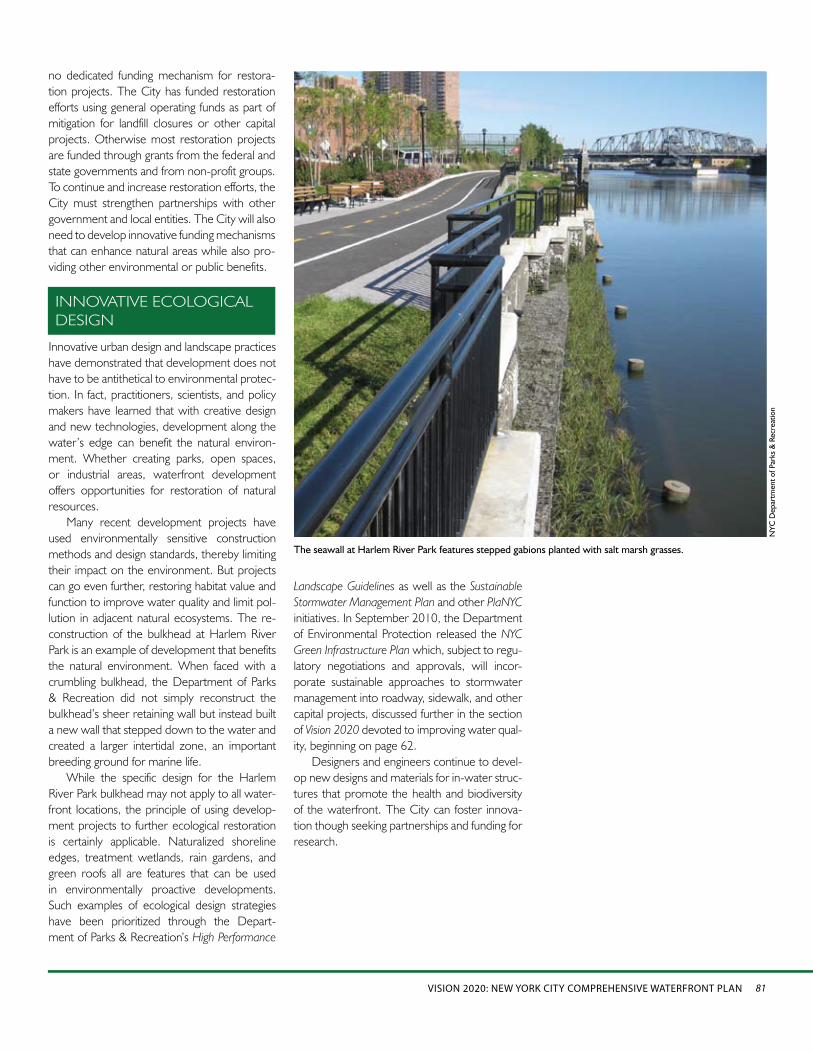
Innovative urban design and landscape practices have demonstrated that development does not have to be antithetical to environmental protec-tion. In fact, practitioners, scientists, and policy makers have learned that with creative design and new technologies, development along the water’s edge can benefit the natural environ-ment. Whether creating parks, open spaces, or industrial areas, waterfront development offers opportunities for restoration of natural resources.
Many recent development projects have used environmentally sensitive construction methods and design standards, thereby limiting their impact on the environment. But projects can go even further, restoring habitat value and function to improve water quality and limit pol-lution in adjacent natural ecosystems. The re-construction of the bulkhead at Harlem River Park is an example of development that benefits the natural environment. When faced with a crumbling bulkhead, the Department of Parks & Recreation did not simply reconstruct the bulkhead’s sheer retaining wall but instead built a new wall that stepped down to the water and created a larger intertidal zone, an important breeding ground for marine life.
While the specific design for the Harlem River Park bulkhead may not apply to all water-front locations, the principle of using develop-ment projects to further ecological restoration is certainly applicable. Naturalized shoreline edges, treatment wetlands, rain gardens, and green roofs all are features that can be used in environmentally proactive developments. Such examples of ecological design strategies have been prioritized through the Depart-ment of Parks & Recreation’s High Performance
INNOVATIVE ECOLOGICAL DESIGN
The seawall at Harlem River Park features stepped gabions planted with salt marsh grasses.
Landscape Guidelines as well as the Sustainable Stormwater Management Plan and other PlaNYC initiatives. In September 2010, the Department of Environmental Protection released the NYC Green Infrastructure Plan which, subject to regu-latory negotiations and approvals, will incor-porate sustainable approaches to stormwater management into roadway, sidewalk, and other capital projects, discussed further in the section of Vision 2020 devoted to improving water qual-ity, beginning on page 62.
Designers and engineers continue to devel-op new designs and materials for in-water struc-tures that promote the health and biodiversity of the waterfront. The City can foster innova-tion though seeking partnerships and funding for research.
no dedicated funding mechanism for restora-tion projects. The City has funded restoration efforts using general operating funds as part of mitigation for landfill closures or other capital projects. Otherwise most restoration projects are funded through grants from the federal and state governments and from non-profit groups. To continue and increase restoration efforts, the City must strengthen partnerships with other government and local entities. The City will also need to develop innovative funding mechanisms that can enhance natural areas while also pro-viding other environmental or public benefits.
NYC
Dep
artm
ent o
f Par
ks &
Rec
reat
ion

RESTORE THE NATURAL WATERFRONT82
VISION 2020 STRATEGIES
VISION 2020 STRATEGIES
ACTION AGENDA PROJECTS
Acquire and augment protection of wetland and other shoreline habitat.1.
Acquire privately owned wetlands and upland habitats where appropriate and where funding •is available. Use plans such as the NYS Open Space Conservation Plan and the Hudson-Raritan Estuary Comprehensive Restoration Plan as the basis for site selection.
Consider modification of the Waterfront Revitalization Program to include designation of •additional sites of ecological importance. Evaluate areas identified by the New York City Audubon Society, New Yorkers for Parks, New York State Department of State, and the Harbor Estuary Program Habitat Workgroup.
Pursue the recommendations of the Wetlands Transfer Task Force. •Assess levels of degradation of currently mapped tidal wetlands and prioritize for protection •and restoration by the New York City Department of Parks & Recreation (DPR), provided funding is available.
Consider revising the Waterfront •Revitalization Program to designate additional sites of ecological importance, such as the Upper Bronx River, Arverne, Plumb Beach, southern portion of the Arthur Kill shoreline, portions of the Raritan Bay shoreline, Staten Island Greenbelt, and Staten Island South Shore Bluebelts. (DCP, 2012)Develop a citywide strategy for •protection and restoration of wetlands and coastal ecosystems. (Mayor’s Office, 2012)Complete transfer of 70-acre Arlington •Marsh property on Staten Island to DPR (DPR/SBS/EDC/DCAS, 2013)Complete transfer of at least 5 additional •City-owned wetland properties to DPR. (DPR/DCAS, 2012)
Increase scientific understanding, public awareness, and stewardship of the natural waterfront.2.
Seek partnerships and funding to support scientific research assessing impacts of in-water •construction and efficacy of restoration methods. Projects should be evaluated based on ecological services, biodiversity, and ecological productivity.
Develop and test innovative designs and materials for in-water structures.•Work with existing waterfront stakeholders to broaden the stewardship base and inform •members of the public about what they can do to improve the health of the waterfront.
Encourage locally based programs in partnership with community groups, schools, and other •institutions that will play an important role in the maintenance and upkeep of the waterfront. Consider establishing an “adopt-a-waterfront” program similar to the adopt-a-highway programs.
Seek to identify and secure funding •for the Hudson-Raritan Estuary by coordinating with federal and state partners. (Mayor’s Office, 2013).Identify opportunities to increase public •awareness and stewardship of specific waterfront reaches, modeling successful public/private partnerships and working with the Partnerships for Parks Catalyst Program to link new conservation, protection or enhancement efforts with existing organizations and programs. (DPR 2012)
ACTION AGENDA PROJECTS
Restore the Natural Waterfront: Strategies and ProjectsThis plan envisions a waterfront in 2020 where wildlife flourishes and natural systems are healthy. Restoring the waterfront’s ecological functions will not only advance biodiversity, it will also help clean waterbodies, make shorelines more resilient, and enhance the waterfront as a place for recreation and appreciation of nature.
To realize this goal, the City will pursue the following set of strategies over the next 10 years. To better protect natural areas, the City
will strengthen policies and improve coordina-tion among government agencies at all levels. The City will continue to actively improve the region’s ecology by restoring shorelines, wet-lands, and coastal forests as well as creating habitat for key species. And it will pilot new res-toration techniques and monitor results.
Vision 2020’s 10-year strategies are comple-mented by the New York City Waterfront Action Agenda, a set of projects chosen for their ability
to catalyze investment in waterfront enhance-ment. The City commits to initiating these projects over the next three years and will be tracking progress on an ongoing basis. For each project, the lead agency and implementation year are noted.
Together, these strategies and projects lay out a comprehensive vision for the waterfront and waterways and a plan of action to achieve that vision.
83VISION 2020: NEW YORK CITY COMPREHENSIVE WATERFRONT PLAN
Pugsley Creek Park, the Bronx: •Complete restoration of tidal wetlands, including excavation work, sand placement, and planting salt marsh grasses. (DPR, 2012)Soundview Park, the Bronx: Complete •restoration of tidal wetlands, including excavation work, sand placement, and planting salt marsh grasses. (DPR, 2013)Paerdegat Basin, Brooklyn: Create •Ecology Park by restoring 12 acres of tidal wetland and 26 acres of adjacent upland habitat. (DEP, 2012)Marine Park, Brooklyn: Restore White •Island, including sand placement, shoreline stabilization, removing invasives, and planting of maritime grasses. (DPR, 2013)Jamaica Bay, Brooklyn: Implement •marshland restoration projects.Sponsor U.S. Army Corps of Engineers’ restoration project at Yellow Bar Hassock. (DEP, 2013)Fresh Creek, Brooklyn: Pilot study of •ribbed mussel beds, evaluating filtration of nutrients and pollutants. (DEP, 2011)Breezy Point, Queens: Study the •feasibility of planting 3,000 eelgrass plants. If planting is successful, begin larger-scale project. (DEP, 2011)Determine opportunities for large-scale •oyster restoration efforts after evaluating the ecological and water quality effects of oyster planting pilot projects undertaken in partnership with the U.S. Army Corps of Engineers, New York/New Jersey Baykeeper, Hudson River Foundation, the New York/New Jersey Harbor Estuary Program, and the Urban Assembly New York Harbor School. (DEP, 2013)Plumb Beach, Brooklyn: Complete a •study to address long-term impacts of shoreline erosion and potentially execute a project partnership agreement with the U.S. Army Corps of Engineers, National Park Service, and New York State Department of Environmental Conservation. (DPR, 2012)
Promote ecological restoration that enhances the robustness and resilience of local and regional 3. ecosystems.
Using the draft • Hudson-Raritan Estuary Comprehensive Restoration Plan (CRP) as a framework, pursue restoration of a mosaic of habitats that provide renewed and increased benefits from the Estuary. Restoration projects should strive to incorporate multiple Target Ecosystem Char-acteristics from the CRP to achieve the greatest ecological benefit at a single location. Concentrate habitat creation and enhancement in protected ecological complexes such as •Special Natural Waterfront Areas.Seek opportunities to restore and create wetlands.•
Partner with the U.S. Army Corps of Engineers and other city, state, and federal agencies o
to prioritize wetlands restoration efforts identified in the CRP.Focus ecological restoration projects in regionally significant ecosystem areas, such as o
Jamaica Bay.Target City-owned wetlands for restoration. o
Work with all appropriate federal, state, and city stakeholders to create new wetlands in o
areas where fragmentation has decimated historic habitat complexes.Seek opportunities to promote local shorebird population.•
Continue to monitor and enhance habitat at known nesting sites. o
Create and expand smaller islands with clean dredged material. o
Coordinate wetland restoration and preservation in proximity to known nesting sites. o
Promote local stewardship and appreciation for NYC waterbirds. o
Seek opportunities to create and restore coastal and maritime forests.•Engage in coastal and maritime forest creation and restoration in protected coastal areas. o
Restore upland forests associated with coastal and maritime forests. o
Collaborate with federal and state authorities to locate and coordinate restoration o
opportunities.Update citywide soils maps to better inform coastal and maritime forest restoration. o
Seek opportunities to improve habitat for oysters, fish, and other aquatic species. •Engage in large-scale oyster reef pilot project and encourage local oysterculture and o
stewardship. Consider the use of alternatives such as blue mussels.Engage in small-scale eelgrass pilot projects with different site conditions and installation o
techniques. Continue monitoring pilot eelgrass program in Jamaica Bay and consider expansion.Install in-water habitat structures, such as reef balls and textured bulkheads, outside o
navigable channels.Remove derelict vessels and degraded bulkheads where feasible. o
Identify opportunities to install riparian vegetation demonstration gardens as buffers o
along waterfront parklands and greenways.Cluster complementary habitat creation efforts such as pairing shorebird islands with o
wetlands.Seek opportunities to create and expand shorelines, shallows, and intertidal areas. Recognize •the important physical, chemical, and biological services of nearshore habitats and sloping or stepped shorelines.Evaluate opportunities to improve tributary connections for aquatic species.•
Further analyze freshwater streams in New York City to identify potential new connec- o
tions, such as at the impoundments on the lower Bronx River where barriers could be removed or passage provided.
Evaluate opportunities to improve water quality in enclosed and confined waters by re-con-•touring bathymetric depressions using dredged materials.Remediate contaminated sediments.•
Adopt initiatives outlined in the o Regional Sediment Management Plan.Prioritize contamination hotspots in New York City for remediation. o
Develop standards for beneficial reuse of clean dredged sediment. o
VISION 2020 STRATEGIES ACTION AGENDA PROJECTS