Amelia Hazard Mitigation Plan of Amelia Hazard Mitigation Plan TABLE OF CONTENTS SECTION PAGE BOARD...
172
Amelia County, Virginia Hazard Mitigation Plan 2005 Prepared with the assistance of: (804) 338-9419
Transcript of Amelia Hazard Mitigation Plan of Amelia Hazard Mitigation Plan TABLE OF CONTENTS SECTION PAGE BOARD...

Amelia County, Virginia Hazard Mitigation Plan
2005
Prepared with the assistance of:
(804) 338-9419

County of Amelia Hazard Mitigation Plan TABLE OF CONTENTS
SECTION PAGE
BOARD OF SUPERVISORS RESOLUTION 1
ACKNOWLEDGEMENTS 2
EXECUTIVE SUMMARY 3
CHAPTER 1 - INTRODUCTION 1-1
1-1 Background 1-1
1-2. Planning Process 1-1
1-3. Resource List for the Hazard Mitigation Team 1-3
1-4. Project Goals and Objectives 1-5
CHAPTER 2 - COMMUNITY PROFILE 2-1
2-1 County Overview 2-1
2-2 Statistical Data 2-1
2-2.1 Location 2-1
2-2.2 Geography 2-1
2-2.3 Government 2-2
2-2.4 Population 2-2
2-2.5 Transportation 2-3
2-2.6 Pipeline 2-6
2-2.7 Hydrology 2-8
2-2.8 Meteorology 2-10
2-2.9 Economics 2-12
2-3 Development Trends 2-13
2-4 Development Potential 2-18

SECTION PAGE CHAPTER 3 - HAZARD IDENTIFICATION AND RISK ASSESSMENT (HIRA) 3-1
3-1 Overview of Hazard Identification and Risk Assessment Process 3-2
3-2 Identifying and Profiling Hazards 3-2
3-3 Past Hazard Events 3-4
3-3.1 Floods 3-5
3-3.2 Hurricanes and Tropical Storms 3-10
3-3.3 Tornados 3-17
3-3.4 Thunderstorms and High Winds 3-26
3-3.5. Lightning 3-30
3-3.6 Hail Storms 3-32
3-3.7 Snow and Ice Storms 3-34
3-3.8 Drought 3-38
3-3.9 Earthquake 3-39
3.3.10 Wildland and Forest Fires 3-42
3-4 Vulnerability and Risk Assessment 3-48
3-4.1 Critical Facilities and Areas of Concern 3-48
3-4.2 Hazards to Critical Facilities and Areas of Concern 3-51
3-4.3 Hazards to Critical Infrastructure and Public Safety Facilities 3-52
3-4.4 Hazards to High Occupancy and Historical Facilities 3-53
3-4.5 Hazards to Transportation 3-54
3-4.6 Power Outages 3-55
3-4.7 Future Growth 3-56
3-4.8 Vulnerability Risk to Structures by Highest Ranking Hazards and Floods 3-57

SECTION PAGE
CHAPTER 4 – CAPABILITY ASSESSMENT 4-1
4-1 Capability Assessment Process 4-1
4-2 Plan Review Matrix 4-1
4-3 Existing Plan Strategies 4-4
4-4 Identify Areas for Improvement and Setting Goals 4-19
CHAPTER 5 – PROPOSED HAZARD MITIGATION STRATEGIES 5-1
5-1 Development of Future Mitigation Strategies 5-1
5-2 Proposed Mitigation Strategies 5-1
5-3 Prioritization of Proposed Mitigation Strategies 5-2
5-4 Mitigation Actions 5-6
CHAPTER 6 – PLAN IMPLEMENTATION AND MAINTENANCE 6-1
6-1 Maintenance and Update of the Amelia County Hazard Mitigation Plan 6-1
6.2 Continued Public Involvement 6-1
CHAPTER 7 – IMPLEMENTATION PLAN 7-1
CHAPTER 8 – IMPLEMENTATION SCHEDULE 8-1
APPENDICIES
APPEIDIX A: LARGE SCALE MAPS
MAP 1 – LOCATION MAP OF AMELIA COUNTY AND SURROUNDING JURISDICTIONS
MAP 2 - VIRGINIA DEPARTMENT OF TRANSPORTATION ROAD MAP
MAP 3 - NORFOLK SOUTHERN RAILWAY MAP
MAP 4 - PLANTATION PIPELINE LOCATION IN AMELIA COUNTY
MAP 8 – INVENTORY OF DAMS
MAP 9 - HURRICANE AND TROPICAL STORM TRACKS IN VIRGINIA
MAP 10, 11, 12 – INDIVIDUAL HURRICANE AND TROPICAL STORM TRACKS

MAP 13 - LOCATIONS OF REPORTED TORNADOS FROM 1983 TO 2004
MAP 17 - USGS MAP OF DECEMBER 9, 2003 EARTHQUAKE NEAR COLUMBIA, VA
MAP 18 - FIRE RANK IN VIRGINIA
MAP 20 AND 21 - POPULATION DENSITY IN 1990 / 2000 IN AMELIA COUNTY
MAP 22 - WILDLAND INTERFACE MAP OF AMELIA COUNTY
MAP 23 - VIRGINIA DEPARTMENT OF FORESTRY 2003 RISK ASSESSMENT
MAP 24- HISTORICAL FIRE DATA SINCE 1985
MAP 25 - CRITICAL FACILITIES AND AREAS OF CONCERN (NOT IN THE VILLAGE)
MAP 26 - CRITICAL FACILITIES AND AREAS OF CONCERN IN THE VILLAGE
MAP 27 - CRITICAL FACILITIES AND AREAS OF CONCERN IN THE VILLAGE (DETAIL) MAP INSERT 1 – VIRGINIA DEPARTMENT OF HIGHWAYS, MAP OF AMELIA COUNTY INCLUDING WATERWAYS
MAP INSERT 2 – FEMA FLOODPLAIN MAPS
APPEIDIX B: PUBLIC AND COMMITTEE MEETING MINUTES
MEETING 1 MINUTES
MEETING 2 MINUTES
MEETING 3 MINUTES
MEETING 4 MINUTES
MEETING 5 MINUTES
MEETING 6 MINUTES
MEETING 7 MINUTES
MEETING 8 MINUTES
APPENDIX C: PUBLIC AND BUSINESS INPUT METHODS
PUBLIC MEETING NOTICES & INVITATIONS TO ADJOINING JURISDICTIONS
QUESTIONAIRE DISTRIBUTION
LETTER AND QUESTIONNAIRE

QUESTIONNAIRE RESULTS

AMELIA COUNTY HAZARD MITIGATION PLAN 2- 7
County of Amelia, Virginia
Board Resolution
WHEREAS the Board of Supervisors of Amelia County, Virginia recognizes the need to identifying hazards to citizens, public and private property, WHEREAS Amelia County recognizes the need to assess the frequency, intensity and potential damage anticipated from these local and regional hazards, WHEREAS Amelia County needs to identify actions and strategies that are intended to protect citizens and reduce or prevent damages to property, WHEREAS Amelia County recognizes a Hazard Mitigation Plan was developed by the County of Amelia Hazard Mitigation Development Team that contains statements of policy, NOW, THEREFORE, BE IT HEREBY PROCLAIMED by the Board of Supervisors of Amelia County, Virginia that this Hazard Mitigation Plan as developed in December, 2005 is officially adopted, and, IT IS FURTHER PROCLAIMED AND ORDERED that the Director of Emergency Services, or his/her designees, are tasked and authorized to maintain and revise as necessary this document. Dated: ______________________ Board of Supervisors, Amelia County, VA _________________________________ _____________________________________ _____________________________________ _____________________________________ _____________________________________ Attest: ____________________________ Clerk, Board of Supervisors Amelia County Commonwealth of Virginia
1

AMELIA COUNTY HAZARD MITIGATION PLAN 2- 8
ACKNOWLEDGEMENTS
The Amelia County Board of Supervisors wishes to extend a special thank you to the following “Hazard Mitigation Development Team” members that assisted in the development of this Plan:
Philip Vannoorbeeck, County Administrator Kent Emerson, Emergency Management and Health Department Jay Flippin, Fire Services Coordinator Steve Binford, Fire Department Ray York, General Services Jamie Surface, Planning Department Joanne Osmore, Planning Department Daray Howarth, American Red Cross Bonita Archer, Virginia Department of Transportation Billy Smith, Virginia Department of Transportation
The Amelia County Board of Supervisors, the County Administrator, the Emergency Management Director and the Hazard Mitigation Development Team members would also like to acknowledge the guidance and efforts of the following:
Hibak Hersi, Virginia Department of Emergency Management
Tamara Caldwell, Virginia Department of Emergency Management
2

AMELIA COUNTY HAZARD MITIGATION PLAN 2- 9
EXECUTIVE SUMMARY
Introduction:
The County of Amelia Hazard Mitigation Plan (herein after, the Plan) serves as a tool for the County and emergency personnel by identifying hazards to citizens, public and private property, assessing the frequency, intensity and potential damage anticipated from these local and regional hazards, and identifying actions and strategies that are intended to protect citizens and reduce or prevent damages to property. The Plan was developed by the County of Amelia Hazard Mitigation Development Team (herein after, the Team) with the assistance of Howlett and Associates, Inc. and contains statements of policy adopted by the Board of Supervisors. The Plan does not constitute any sections of the County of Amelia's Master Plan, County Ordinances, or Regulations. Hazard Analysis: The various hazards were reviewed under the following categories as outlined below: 1. Floods 6. Hail Storms 2. Hurricanes and Tropical Storms 7. Snow and Ice Storms 3. Tornadoes 8. Drought 4. Thunderstorms and High Winds 9. Earthquake 5. Lightning 10. Wildland Fires Critical Facilities and Areas of Concern The various critical facilities and areas of concern were reviewed and are identified below:
• Government Office Buildings • Courthouses • Rescue Stations, Fire Stations and Law Enforcement Facilities • Emergency Communications Center • Public Safety Communications Radio Tower • Schools • Water Distribution Facilities • Sewage Treatment Facilities • Nursing Homes • Historical Structures • Road and Rail Transportation Routes
3

AMELIA COUNTY HAZARD MITIGATION PLAN 2- 10
Areas of Concern:
• Child Day Care Centers • Libraries • Apartment Complexes • Recreational facilities
• Industrial Complexes • Landfills • Road and Rail Transportation Routes
The County of Amelia Hazard Mitigation Plan should be considered a work in progress and needs to be reviewed on a regular basis to assess whether the existing and suggested mitigation strategies are successful. A copy will remain on file at the Amelia County’s Administrative Office. CHAPTER 1 - INTRODUCTION
1-1 Background The Federal Emergency Management Agency (FEMA) has mandated that all communities within the Commonwealth of Virginia establish local hazard mitigation plans as a means to reduce future losses from natural hazard events before they occur. In response to this mandate, the Virginia Department of Emergency Management will assist local communities, through direct involvement in plan development, through guidance with updates and through education outreach, so communities, such as the County of Amelia are provided a working local hazard mitigation plan and the tools necessary to maintain it. This All-Hazard Mitigation Plan was prepared in accordance with the County of Amelia's Emergency Operations Plan, dated August 2004, and the Amelia Comprehensive Plan 2000 – 2025 as revised 12/17/2003 and under the authority of the Planning Mandate of Section 409 of Public Law 93-288 as amended by Public Law 100-707, the Robert T. Stafford Act of 1988, hereinafter referred to as the "Stafford Act." As previously stated, the All-Hazard Mitigation Plan is also referred to as the "Plan." This Plan is funded in part by a grant from the Virginia Department of Emergency Management. 1-2 The Planning Process On April 4, 2005 the County of Amelia held an organizational meeting with County and State Representatives as well as County Citizens to begin developing the County of Amelia’s Hazard Mitigation Planning Team, and participants from this team developed the contents of the Plan. The Amelia County participants agreed to make contact with all adjoining jurisdictions, all County Agencies, local businesses, and any outside agencies that should be involved in this process. The County Administrator agreed to accept the responsibility of making the proper contacts. Methods of requesting participation is addressed in detail in Appendix C of this document. The following is a summary of the nine-step process conducted to compile the County of Amelia Hazard Mitigation Plan. Step 1 – Establish and Orient Hazard Mitigation Team In early 2005, the Amelia County Board of Supervisors agreed that the County Administrator would act as the single point of contact for the planning process. The County Administrator contracted with Howlett and Associates, Inc. to facilitate this process. The Team met as follows: April 4th, 2005; May 24th, 2005, (with the LEPC); May 24th with the full Team; October 11th, 2005; November 8th, 2005;
4

AMELIA COUNTY HAZARD MITIGATION PLAN 2- 11
and December 13th, 2005. Additional meetings are identified but dates have not been finalized as of this edition. Three meeting notices were published in the Amelia Bulletin newspaper. Additional meeting notices were published in surrounding jurisdictions. In addition, the County Administrator mailed letters to adjoining jurisdictions notifying them that Amelia County will begin the development of a Mitigation plan and invited them to the fall meetings for input. A questionnaire was developed to request input from local citizens, businesses, and civic organizations. The questionnaire was put on the Amelia County Website with an email address for anyone to respond with their input. Step 2 – Map the Hazards and Identify Critical Facilities Howlett and Associates, Inc. presented an overview of the hazard mitigation planning process using a PowerPoint presentation. The hazard mitigation goals were set. Participants identified areas where damage from natural disasters have occurred and areas where critical man-made facilities and structures may be at risk. They also evaluated the possibility of future loss of life, property damage, environmental pollution, and other risk factors. A set of base maps were generated and used in the process of identifying past and possible future hazards. Participants then identified facilities and areas that are considered important to the County for emergency management purposes, for provision of utilities and community services, evacuation routes, and for recreational and social value. Using existing databases, local community maps, local assessing data, and floodplain maps, the Team plotted the location of these sites on a map. Team members identified the following natural hazards that have affected or may affect the County of Amelia in a significant manner: 1. Floods 6. Hail Storms 2. Hurricanes and Tropical Storms 7. Snow and Ice Storms 3. Tornadoes 8. Drought 4. Thunderstorms and High Winds 9. Earthquake 5. Lightning 10. Wildland and Forest Fires
The Team brainstormed the type of hazards and locations that have sustained or could be susceptible to each hazard within the County. The results are identified in Chapter III, Community Hazards and several maps were developed illustrating the locations of past hazards. The Team then identified and catalogued all of the critical facilities and areas of concern within the County. The results are identified in Chapter 3, and on Map 25, 26, and 27 in Appendix A showing the locations of Critical Facilities and Areas of Concern. Step 3 – Assessing Vulnerability Once the critical facilities and areas of concern were identified, the Team discussed the potential loss of critical facilities. The Team members completed Vulnerability Assessment discussions for all of the hazards identified in Step 2. Risk assessment and calculated potential loss estimates, which utilizes the data collected in this step can be found in Chapter 3. This section also contains a Critical Facilities Matrix that ranks each critical facility and area of concern by the potential risk of being affected by a natural hazard. Each hazard is ranked as having a low, medium or high risk of potentially affecting the facility. See Chapter 3, Vulnerability Assessment. Step 4 - Analyzing Development Trends Development trends were identified in the County of Amelia Master Plan and are summarized in Chapter 2, Development Trends. Future development trends were identified at the end of Chapter 4, Assessment of Future Development Losses.

AMELIA COUNTY HAZARD MITIGATION PLAN 2- 12
Step 5 - Identify what’s in Place and Gaps in Current Protection After collecting detailed information on each critical facility in the County of Amelia, the committee will conducted a vulnerability assessment and identified how each individual hazard affects the citizens, structures, critical facilities, and areas of concern. The committee will then conduct a capability assessment to review their existing policies, regulations, and programs to determine where improvements can be made that will identify areas where improvements would assist in mitigating hazards. Step 6 – Brainstorm and Evaluate Mitigation Strategies After developing a list of existing hazard mitigation strategies, the team was able to identify gaps in the existing mitigation measures. These gaps were taken into consideration during the development of mitigation goals and proposed mitigation measures. Current strategies that have been implemented include a zoning ordinance that prohibits construction in the 100 or 500 year flood plain and providing emergency power to critical facilities. Step 7 – Select Actions The proposed hazard mitigation actions and strategies were reviewed and each strategy was rated (High, Moderate and Low) for its effectiveness according to seven factors (e.g., technical and administrative applicability, political and social acceptability, legal authority, environmental impact and financial feasibility). Each factor was scored, and scores were totaled for each strategy. Strategies were ranked by overall score for preliminary prioritization and reviewed again under Step 8. The preliminary prioritization list was reviewed and amended until the prioritization list for new hazard mitigation actions and existing protection strategy improvements, identified in previous steps, was finalized. Step 8 – Develop a Strategy An implementation strategy utilizing a chart provided in Step 8 of the Guide to Hazard Mitigation Planning was developed. Included in the strategy are person(s) responsible for implementation (Who), a timeline for completion (When), and a funding source and/or technical assistance source (How) for each identified hazard mitigation action. Step 9 – Adopt and Monitor the Plan, and Continued Public Input The Team members reviewed and approved each section of the plan as it was completed. After acceptance by the Team, the Board of Supervisors will be presented with a recommendation for the approved the Plan pending approval by the Virginia Department of Emergency Management and Federal Emergency Management Agency (FEMA) Region 3. After incorporation of comments from Virginia Department of Emergency Services and FEMA, the Plan will be presented at a public meeting and the Board of Supervisors for formal approval and adoption of the County of Amelia Hazard Mitigation Plan as noted on the Adoption Resolution page at the beginning of this Plan. It is recommended to review the plan yearly and schedule the maintenance and update of this plan in conjunction with the update to the Emergency Operations Plan or after a presidential disaster declaration. Maintenance updates are required every five years and either an annual or a biannual review is recommended to determine when the appropriate time within the five year cycle the maintenance update should be conducted. The Emergency Management Director / County Administrator should be responsible for coordinating and assuring that the County Departments and the public are engaged in the maintenance and update of the Hazard Mitigation Plan. Review of ongoing and/or completed mitigation projects and, if

AMELIA COUNTY HAZARD MITIGATION PLAN 2- 13
necessary, development of additional strategies are recommended. If a Pre-disaster Mitigation (PDM) grant or other Federal grants are requested, a benefit cost analysis (BCA) is required for projects to be eligible for monies.
1-3 Resource List for the Hazard Mitigation Team The County of Amelia Emergency Management Director (EMD) reviewed and coordinated with the following agencies, detailed in Table 1, in order to determine if there were any potential areas for cooperation. All agencies mentioned below were contacted by the County Administrator or the Team and either attended Team meetings or provided input and guidance through telephone conversation, email or printed data. All County Agencies, citizens, businesses, non-profit organizations, and neighboring communities were notified of the planning process and invited to participate in the meetings. Telephone calls, Public Notices in newspapers, direct mailing, and questionnaires were utilized to solicit participation in the process. The methods utilized to contact all of the above are detailed in Appendix C.

AMELIA COUNTY HAZARD MITIGATION PLAN 2- 14
INVITED TO MEETINGS AND DID NOT ATTEND
Sheriff Jimmy Weaver (804) 561-2118
Schools
Elementary Middle
High
(804) 561-2433 (804) 561-4422 (804) 561-2101
Social Services (804) 561-2681
Animal Control (804) 561-3878
Library (804) 561-4559
Extension Agent (804) 561-2481
TABLE 1: COUNTY OF AMELIA EMERGENCY MANAGEMENT PLAN TEAM CONTACT LIST
AGENCY CONTACT NUMBER
ATTENDED MEETINGS
Amelia County Administrator Philip Vannoorbeeck (804) 561-3039
Department of Health, Amelia District Kent Emerson (434) 392-3984
Amelia County Volunteer Fire Departments Jay Flippin (804) 717-6104
Amelia County Planning Department Joanne Osmore (804) 561-3039
Red Cross Daray Howarth
Virginia Department of Transportation Billy Smith (804) 561-0603
Virginia Department of Emergency Management Hibak Hersi (804) 897-6500
Virginia Department of Emergency Management Tamara Caldwell (804) 897-6500
PROVIDED DATA
Virginia Department of Forestry Doug Augley (804) 561-2427
Va. Dept. of Recreation and Conservation Mark Slauter (804) 371-6135

AMELIA COUNTY HAZARD MITIGATION PLAN 2- 15
1-4 Project Goals and Objectives The County of Amelia listed their Goals and Objectives in the following order:
1. To improve upon the protection of the general population, the citizens of the County and guests, from all natural and man-made hazards.
2. To reduce the potential impact of natural and man-made disasters on Critical Facilities in
the County. 3. To reduce the potential impact of natural and man-made disasters on the
County’s infrastructure. 4. To reduce the potential impact of natural and man-made disasters on private property. 5. To reduce the potential impact of natural and man-made disasters on the County’s
natural environment. 6. To increase the County’s proactive approach to hazard mitigation. 7. To reduce the potential impact of natural and man-made disasters on the County’s specific
historic treasures and interests as well as other tangible and intangible characteristics which add to the quality of life of the citizens and guests of the County.
8. To identify, introduce and implement cost effective Hazard Mitigation measures so as to
accomplish the County’s Goals and Objectives and to raise the awareness, and acceptance of Hazard Mitigation generally.
CHAPTER 2 – COMMUNITY PROFILE 2-1 County Overview MAP 1 - Location Map of Amelia County, Virginia and Surrounding
Jurisdictions
AMELIA

AMELIA COUNTY HAZARD MITIGATION PLAN 2- 16
MAP PROVIDED BY NOAA COASTAL SERVICES CENTER 2-2 Statistical Data 2-2.1 Location Amelia County is located in central Virginia southwest of the Richmond metropolitan area. 2-2.2 Geography
Amelia County is bordered by Powhatan County to the north, Chesterfield County to the east, Dinwiddie County to the southeast, Nottoway County to the south, Prince Edward County to the southwest, and Cumberland County to the northwest. Amelia County contains 366 square miles. The elevation ranges between 200 and 500 feet above sea level. The main population area in Amelia County is centrally located within the county near the area of Amelia Courthouse. There are other smaller population centers in the Paineville area, Jetersville area, Mannboro area, and Chula area. The remaining areas of the county are largely rural with farmland and residential areas. There are no incorporated towns located within Amelia County.

AMELIA COUNTY HAZARD MITIGATION PLAN 2- 17
2-2.3 Government Amelia County is governed by a Board of Supervisors. There are five elected Supervisors, each representing one of the five voting districts. There is a County Administrator appointed by the Board of Supervisors. There are five constitutional officers: Treasurer, Commissioner of Revenue, Sheriff, Clerk of Circuit Court, and Commonwealth's Attorney. There is also a five member elected School Board. 2-2.4 Population – Census 2000 General Characteristics Number Percent U.S.
Total population 11,400 100.0 100% Male 5,622 49.3 49.1% Female 5,778 50.7 50.9%
Median age (years) 38.5 (X) 35.3 Under 5 years 716 6.3 6.8% 18 years and over 8,511 74.7 74.3% 65 years and over 1,514 13.3 12.4%
One race 11,324 99.3 97.6%
White 8,045 70.6 75.1% Black or African American 3,198 28.1 12.3% American Indian and Alaska Native 32 0.3 0.9% Asian 19 0.2 3.6% Native Hawaiian and Other Pacific Islander 2 0.0 0.1% Some other race 28 0.2 5.5% Two or more races 76 0.7 2.4%
Hispanic or Latino (of any race) 91 0.8 12.5%
Average household size 2.66 (X) 2.59 Average family size 3.07 (X) 3.14
Total housing units 4,609 100.0 100.0%
Occupied housing units 4,240 92.0 91.0% Owner-occupied housing units 3,474 81.9 66.2% Renter-occupied housing units 766 18.1 33.8%
Vacant housing units 369 8.0 9.0%

AMELIA COUNTY HAZARD MITIGATION PLAN 2- 18
Social Characteristics >> Number Percent U.S.
Population 25 years and over 7,789 100.0 High school graduate or higher 5,316 68.3 80.4% Bachelor's degree or higher 760 9.8 24.4%
Civilian veterans (civilian population 18 years and over) 1,224 14.4 12.7% Disability status (population 21 to 64 years) 1,677 25.4 19.2% Foreign born 80 0.7 11.1% Now married (population 15 years and over) 5,241 58.1 54.4% Speak a language other than English at home (5 years and over) 279 2.6 17.9%
Economic Characteristics - >> Number Percent U.S.
In labor force (population 16 years and over) 5,731 65.2 63.9% Mean travel time to work in minutes (population 16 years and over) 41.5 (X) 25.5
Median household income (dollars) 40,252 (X) 41,994 Median family income (dollars) 47,157 (X) 50,046 Per capita income (dollars) 18,858 (X) 21,857
Families below poverty level 214 6.7 9.2% Individuals below poverty level 948 8.4 12.4%
Housing Characteristics - show more >> Number Percent U.S.
Single-family owner-occupied homes 1,755 100.0 Median value (dollars) 92,400 (X) 119,600
Median of selected monthly owner costs (X) (X) With a mortgage 803 (X) 1,088 Not mortgaged 216 (X) 295
(X) Not applicable. Source: U.S. Census Bureau, Summary File 1 (SF 1) and Summary File 3 (SF 3) 2-2.5 Transportation Amelia County is bisected east to west by US Route 360. This is a four lane corridor. State Route 153 runs north-south in the eastern side of Amelia County connecting Rt. 360 to US Route 460 in Nottoway County. State Route 307 runs east-west in the southwestern end of Amelia County connecting Rt. 360 to Rt. 460 in Prince Edward County. State Route 38 runs generally east-west in the central area of Amelia County connecting the Village of Amelia Courthouse to Rt. 153. There are numerous secondary roads throughout Amelia County.

AMELIA COUNTY HAZARD MITIGATION PLAN 2-19
MAP 2 - VIRGINIA DEPARTMENT OF TRANSPORTATION ROAD MAP OF AMELIA COUNTY
Map provided by the Virginia Department of Transportation Enlarged Version Available in Appendix A

AMELIA COUNTY HAZARD MITIGATION PLAN 2-20
Amelia County contains one rail line running generally east-west paralleling US Route 360. This is a Norfolk Southern Rail Line. MAP 3 - NORFOLK SOUTHERN RAILWAY MAP Map provided by the National Atlas of the United States, Larger Version Available in Appendix A
NORFOLK SOUTHERN RAILWAY

AMELIA COUNTY HAZARD MITIGATION PLAN 2-21
2-2.6 Pipeline There is one major pipeline that runs through Amelia County. This is owned by Plantation Pipeline. It runs generally north-south bisecting the county on the eastern side. MAP 4 - PLANTATION PIPELINE LOCATION IN AMELIA COUNTY Map provided by Virginia Department of Transportation Location of Pipeline provided by Plantation Pipeline, Larger Version Available in Appendix A
PLANTATION PIPELINE

AMELIA COUNTY HAZARD MITIGATION PLAN 3-22
Area Description
The products transported through the Plantation Pipeline are refined fuels such as gasoline, diesel fuel, fuel oil, and turbine fuel. The regional supervisor for the section of the pipeline that penetrates Amelia County is Mr. D. B. Henderson. He serves from the North Carolina - Virginia State Line through the City of Richmond north to the City of Fredericksburg.
Counties Traversed by Plantation Pipeline in Virginia
Halifax, VA Charlotte, VA
Mecklenburg, VA Lunenburg, VA
Nottoway, VA Amelia, VA
Chesterfield, VA City of Richmond, VA
Goochland, VA Henrico, VA
Hanover, VA Caroline, VA
Spotsylvania, VA City of Fredericksburg, VA
24 Hour Emergency Contact #: 1-800-510-5678

AMELIA COUNTY HAZARD MITIGATION PLAN 3-23
6
5 4
3
1 2
7 8 9
10
2-2.7 Hydrology Amelia County contains many streams, creeks, ponds, and lakes. Some of these are public and some are private. Amelia County is located entirely within the watershed of the Appomattox River. The Appomattox River forms the northern boundary of Amelia County. Below is the Appomattox River watershed (source US EPA). Primary waterways in Amelia County include the Appomattox River, Creeks, Streams, and Branches that flow from the Appomattox River into the County. They are located in the map below:
1. Appomattox River 2. Winticomack Creek 3. Beaverpond Creek 4. Smacks Creek 5. Flat Creek 6. Dolittle Creek 7. Bent Creek 8. Stock Creek 9. Sandy Creek 10. Dawsons Creek
MAP #5 – AMELIA COUNTY WATERWAYS (All waterways are identified on large folded map inserted at the end of Appendix A)
MAP PROVIDED BY THE VIRGINIA DEPARTMENT OF FORESTRY REFER TO LARGER FOLDING MAP OF AMELIA COUNTY AT THE END OF APPENDIX A FOR ALL AMELIA COUNTY WATERWAYS

AMELIA COUNTY HAZARD MITIGATION PLAN 3-24
Rivers and Streams in this Watershed: 11 (provided by EPA's first River Reach File) Lakes in the watershed: 275; total number of acres: 8294.8 River and stream miles:
2160 total river miles
1634.3 perennial river miles
The following aquifer's are in this huc:
Aquifer SquareMiles Rock Type
No Principal Aquifer 1293 N/A Early Mesozoic basin aquifers 179 Sandstone aquifers Northern Atlantic Coastal Plain aquifer system 132 Semi-consolidated sand aquifers

AMELIA COUNTY HAZARD MITIGATION PLAN 3-25
2-2.8 Meteorology
Amelia County is susceptible to widely varying weather events. Amelia County can experience winter storms, including snow and ice, severe storms, including lightning, hail, tornadoes and hurricanes, and drought conditions. The following chart is provided by the Virginia State Climatology Office.
1 AMELIA 4 SW, VIRGINIA (440187)
1.1.1 Period of Record Monthly Climate Summary
1.1.1.1 Monthly Climate Period of Record: 1/1/1970 to 3/31/2003 Jan Feb Mar Apr May Jun Jul Aug Sep Oct Nov Dec Annual Average Max. Temperature (F) 46.6 50.4 59.2 69.6 77.0 84.9 88.5 86.8 81.1 70.8 61.0 51.3 68.9
Average Min. Temperature (F) 24.8 27.0 33.8 42.2 51.5 60.5 64.8 63.1 56.0 43.6 35.5 28.3 44.3
Average Total Precipitation (in.) 3.50 3.24 4.35 3.20 3.81 3.18 4.41 4.07 3.83 4.06 3.64 2.98 44.27
Average Total Snow Fall (in.) 4.5 4.1 1.5 0.3 0.0 0.0 0.0 0.0 0.0 0.0 0.3 1.7 12.4
Average Snow Depth (in.) 0 0 0 0 0 0 0 0 0 0 0 0 0
Percent of possible observations for period of record. Max. Temp.: 93.4% Min. Temp.: 93.3% Precipitation: 93.9% Snowfall: 93.2% Snow Depth: 90.6%
The following information is provided based on readings from Richmond, which is the closest monitoring station for these values to the County of Amelia. This information is provided by the National Climatic Data Center:
Average Relative Humidity
ELEMENT Period of Record JA
N
FEB
MA
RC
H
APR
IL
MA
Y
JUN
E
JULY
AU
G
SEP
OC
T
NO
V
DEC
YEA
R
Normal Relative Humidity (Percent) 30 68 66 63 61 70 72 75 77 77 74 69 69 70

AMELIA COUNTY HAZARD MITIGATION PLAN 3-26
Average Wind Data
ELEMENT Period of Record
J A N
F E B
M A R
A P R
M A Y
J U N
J U L
A U G
S E P
O C T
N O V
D E C
Y E A R
Mean Wind Speed (MPH) 38 8.3 8.7 9.3 9.2 7.9 7.5 7.1 6.6 7.0 7.2 7.7 7.9 7.9Prevailing Wind Direction (tens of
degrees) 21 36 36 36 19 19 19 19 18 36 36 36 36 18
Average Barometric Pressure
ELEMENT Period of Record
J A N
F E B
M A R
A R P
M A Y
J U N
J U L
A U G
S E P
O C T
N O V
D E C
Y E A R
Mean Sea-Level Pressure (in.) 13 30.12 30.09 30.06 29.98 30.01 29.99 30.01 30.05 30.09 30.12 30.14 30.15 30.0
7

AMELIA COUNTY HAZARD MITIGATION PLAN 3-27
2-2.9 Economics
NAICS Code Description Establishments
Sales Receipts or Shipments
($1,000)
Annual Payroll ($1,000)
Paid Employees
21 Mining (not published for counties) N N N N
22 Utilities (not published for counties) N N N N
23 Construction (not published for counties) N N N N
31-33 Manufacturing (none) N N N N 42 Wholesale trade 9 41,092 4,790 167 44-45 Retail trade 36 41,022 3,974 226
48-49 Transportation & warehousing (not published for counties) N N N N
51 Information (total not published for counties) N N N N
52 Finance & insurance (not published for counties) N N N N
53 Real estate & rental & leasing 3 887 110 6
54 Professional, scientific, & technical services 7 841 311 24
55 Management of companies & enterprises (not published for counties)
N N N N
56 Administrative & support & waste management &remediation services
6 D D (20-99)
61 Educational services 2 D D (1-19) 62 Health care & social assistance 8 3,520 1,835 110
71 Arts, entertainment, & recreation (none) N N N N
72 Accommodation & foodservices 7 2,248 571 78
81 Other services (except public administration) 23 2,581 619 44
D = Withheld to avoid disclosure; N = Not available Source: 1997 Economic Census

AMELIA COUNTY HAZARD MITIGATION PLAN 3-28
2-3 Development Trends
The traditional development pattern of the County has generally been one of single family dwellings on rural lots, sparsely scattered among forests and farms, as well as small clusters of structures in compact settlements. Small country stores and churches serve as community focal points, with the courthouse area the central focus for the County. New residential development has tended to occur as either incremental, single lot development or small, rural subdivisions in a somewhat scattered, “strip” pattern, based upon the opportunities provided by road frontage, permeable soils and ownership intentions to develop. During recent years, the relatively low cost of rural residential lots, combined with the access to jobs in the Richmond and Petersburg areas have increased the demand for rural housing development in Amelia. With improved transportation and communication technologies, households and employment centers tend to become more dispersed, as home buyers seek the lowest land prices and more comfortable rural lifestyles.
The larger commercial and industrial establishments have tended to concentrate along the Route 360 corridor, north of Route 360 and along Route 153. Commercial uses have also concentrated in the Courthouse area, along with most of the public buildings. The Courthouse area has declined somewhat, however, as a commercial center for the County, likely due in part to the construction of the nearby shopping center on Route 360 and by the increased accessibility of residents to commercial centers in neighboring jurisdictions. The population of Amelia County has increased from 11,400 in the year 2000 to 13,500 currently. The current trend is to continue to follow the County’s Comprehensive Plan and concentrate the next significant residential growth as planned in the Village of Amelia Courthouse. All of this planned development is outside the 100 year and 500 year floodplain enforced by the County in the form of a County Ordinance prohibiting construction in the floodplain. This provides a controlled growth pattern directly related to the County’s ability to provide services and utilities. The inability to provide acceptable response times for public safety services into the outer portions of the 366 square miles of the County restricts large growth plans in the more rural areas. There is a zoning request on record for 2,000 residential homes in the village of Amelia Courthouse that meets the County Comprehensive Plan. This has the potential of doubling the population of the County over the next eight years. It is anticipated that this residential growth will also spark commercial, retail, and light industrial growth in the Amelia Courthouse area and along the Route 360 corridor. There are no immediate plans or projection for the expected commercial growth at this time.

AMELIA COUNTY HAZARD MITIGATION PLAN 3-29
This is an illustration from the Amelia Comprehensive Plan, 2000-2025 that is updated yearly. The illustration shows the current areas allotted for planned development for the future growth in the Amelia Courthouse Village and the Route 360 corridor.
Proposed Conceptual Future Development Pattern for the Amelia Courthouse Area RESIDENTIAL
COMMERICAL / MIXED USE
LIGHT INDUSTRIAL
PUBLIC / SEMI-PUBLIC
VILLAGE GREEN
OPEN SPACE / BUFFER
MAP PROVIDED BY AMELIA COUNTY / 2000 – 2025 COMPREHENSIVE PLAN

AMELIA COUNTY HAZARD MITIGATION PLAN 3-30
TABLE 2 - Number of Building Permits County-Wide by Land Use Category
(1981 - 2000)*
Year Residential Commercial / Non-Residential Mobile Homes
1981 58 15 33**
1982 46 30 27**
1983 81 18 49**
1984 73 23 48**
1985 96 6 60**
1986 95 4 60**
1987 60 5 58**
1988 98 11 90**
1989 64 13 99
1990 81 4 98
1991 71 3 94
1992 94 29 109
1993 66 20 79
1994 99 22 87
1995 89 26 106
1996 79 31 66
1997 97 22 87
1998 98 25 78
1999 88 17 81
2000 76 21 81
TOTALS 1,609 345 1,490
Source: “Annual Units Authorized in Virginia’s Counties and Cities,” Center for Public Service, University of Virginia; Amelia County Planning Office Notes: * does not include other permits such as additions and alterations, agricultural structures and non-taxable structures
** Data from 1991 Comprehensive Plan

AMELIA COUNTY HAZARD MITIGATION PLAN 3-31
TABLE 3 - Value of Construction Countywide by General Land Use Category
(1989 - 2000)*
Year Residential Commercial / Non-Residential
(in thousands of dollars) Mobile Homes 1989 $3,440 $1,835 $1,589
1990 4,609 1,150 1,285
1991 4,464 618 1,522
1992 5,626 906 1,712
1993 4,150 596 1,213
1994 5,772 382 1,450
1995 7,335 864 2,150
1996 7,195 1,566 2,253
1997 8,802 6,645 2,532
1998 7,444 1,077 3,353
1999 8,634 854 3,786
2000 8,559 2,573 3,355
Totals $76,030 $19,066 $26,200
Source: Amelia County Planning Office: Herd Planning & Design Notes: *does not include other permits such as additions and alterations, agricultural structures and non-taxable structures; values as indicated by building permits, not assessments; not adjusted for inflation; all figures are rounded.

AMELIA COUNTY HAZARD MITIGATION PLAN 3-32
TABLE 4 - General Land Use Types in County of Amelia
Land Use Category* General, Working Definition
Generally Corresponding Zoning Districts
Agriculture Agriculture (20 to 99 acres) Agriculture (over 99 acres)
active or in-active farmland A-5 Agricultural RP-5 Agricultural Preservation RR-3 Rural Residential
Forest Agriculture (20 to 99 acres) Agriculture (over 99 acres)
land with forest cover A-5 Agricultural RP-5 Agricultural Preservation RR-3 Rural Residential
Rural Residential Single Family Residential (Urban) Single Family Residential (Suburban)
residential lots w/o public water or sewer, constructed at overall density of no greater than one unit per acre and not in an urban area
A-5 Agricultural RP-5 Agricultural Preservation RR-3 Rural Residential
Urban Residential Single Family Residential (Urban) Single Family Residential (Suburban) Multi-Family Residential
dwellings with public sewer or within urban settlements
R-1 Residential R-2 Residential
Commercial Commercial / Industrial
retail, wholesale, office B-1 Business B-2 Business B-3 Shopping Center
Industrial Commercial / Industrial
manufacturing, assembly, and warehouse, mills, refineries
M-1 Industrial M-2 Industrial
Public and other Exempt (government, religious, etc.)
semi-public and government uses such as schools, parks, utilities, public roadways, etc.
(multiple districts)
Source: Herd Planning & Design Note: *Bold Face type indicates general categories for planning purposes; plain type indicates closest corresponding categories of the Commissioner of the Revenue data.

AMELIA COUNTY HAZARD MITIGATION PLAN 3-33
TABLE 5 - Land Use Category % Land Area of County Approximate
Estimated Current Land Use, County-Wide
Agriculture (over 99 acres) 60+ %
Single Family Residential (Urban) < 1%
Single Family Residential (Suburban) 6 %
Multi-Family Residential <1 %
Commercial / Industrial <1 %
Exempt (government, religious, etc.) 1 %
Total 100%
Sources: Data from the Commissioner of the Revenue, 1993; Herd Planning & Design, Ltd. Note: All figures rounded
2-4 Development Potential
The development potential allowed by existing zoning of undeveloped land is still very large due to the total acreage involved and far exceeds the expected land demand for the next 20 years. Thousands of housing could be built in the County under the new A-5 and RP-5 districts, in addition to the potential construction in the higher intensity RR-3 and R districts. The potential for future growth is high and will be controlled by the County Comprehensive Plan. The ability to provide utilities and services in the courthouse village area of the County has already provided the ability to plan for an additional 2,000 residential lots to be developed that has the potential of doubling the population over the next eight years. This will spark commercial, retail, and light industrial growth to support the additional population. The remaining land mass of the County will remain rural and sparsely populated until an expansion of utilities and services can be supported by County’s financial plan. County ordinance prohibits construction in the 100 year or 500 year floodplains. This ordinance is strictly enforced. Refer to Section 2-3 on previous pages 2-14 and 2-15 of this chapter for the details of current plans for growth and an illustration of the areas designated in the current County Comprehensive Plan.
CHAPTER 3 - Hazard Identification and Risk Assessment (HIRA)

AMELIA COUNTY HAZARD MITIGATION PLAN 3-34

AMELIA COUNTY HAZARD MITIGATION PLAN 3-35
3-1 OVERVIEW OF THE HAZARD IDENTIFICATION AND RISK ASSESSMENT (HIRA) PROCESS The Hazard Identification and Risk Assessment (HIRA) for the County of Amelia, Virginia was conducted by Howlett and Associates, Inc. in cooperation with Amelia County Administration, Departments, Local Emergency Planning Committee, other local and state agencies, and citizens organizations. The following sections of the HIRA will cover the following three main requirements: Identifying and Profil ing Hazards Assessing Vulnerabilities Estimating Potential Losses The Amelia County Emergency Operations Plan and the Amelia County Comprehensive Plan were primary documents utilized to identify several areas of data collection necessary for the HIRA. The Amelia County Emergency Operations Plan was a report that addressed hazard mitigation and was thoroughly reviewed as part of this process. Any information made available from the Emergency Operations Plan was verified by Amelia County Officials including the local Emergency Services Director and Manager. 3-2 IDENTIFYING AND PROFILING HAZARDS The HIRA only focused on natural hazards and their impacts since the Amelia County Emergency Operations Plan addresses human-caused hazards to varying extents. The first step in planning for natural hazards is to identify the specific hazards that may affect the County. Each community is unique in location, topography, size and complexity of watersheds, location of critical facilities, extent of roads, utilities, commercial and residential Development, etc. Some municipalities are more susceptible to certain hazards because of these and other unique circumstances (i.e., flooding near rivers, hurricanes, winter storms, etc.). The hazards that are most applicable to the County include severe weather and wildland fires. The hazards that are addressed in this plan will include: 1. Floods 6. Hail Storms 2. Hurricanes and Tropical Storms 7. Snow and Ice Storms 3. Tornadoes 8. Drought 4. Thunderstorms and High Winds 9. Earthquake 5. Lightning 10. Wildland and Forest Fires
TABLE 6 - Natural Hazards Addressed in the Amelia County Mitigation Plan

AMELIA COUNTY HAZARD MITIGATION PLAN 3-36
* All Data References include input from County and State Agencies participating as the Amelia County Hazard Mitigation Planning Committee
HAZARD TYPE RELATIVE
RISK CATEGORY
ANALYSIS LEVEL
DATA REFERENCE
Creeks LOW FEMA* Rivers LOW FEMA* FLOODING Dam Failures LOW
Covered by HIRA Flood
Analysis FEMA* Hurricane, general LOW NCDC* Tropical Depression LOW NCDC*
Tropical Storms LOW NCDC* Category 1 LOW NCDC* Category 2 LOW NCDC*
HURRICANES
Category 3 LOW
Covered by HIRA Hurricane
Analysis
NCDC* Tornadoes, general MEDIUM NCDC* F0 MEDIUM NCDC* F1 MEDIUM NCDC* F2 LOW NCDC*
TORNADOES
F3 LOW
Covered by HIRA Tornado
Analysis NCDC*
THUNDERSTORMS AND HIGH WINDS
Thunderstorms, high winds, lightning, and including hail
LOW
Covered by HIRA
Thunderstorm Analysis
NCDC*
BLIZZARDS, SNOW STORMS, AND ICE
STORMS
Including winter storms, Nor’easters, ice storms, and excessive cold
LOW Covered by HIRA Winter
Storm Analysis NCDC*
DROUGHT Excessive heat LOW Covered by Description NCDC*
EARTHQAKE LOW Covered by Description NCDC*
WILDFIRE
MEDIUM Covered by
HIRA Wildfire Analysis
Virginia Division of Forestry*

AMELIA COUNTY HAZARD MITIGATION PLAN 3-37
3-3 HAZARD IDENTIFICATION AND COMMUNITY IMPACTS The next step in hazard mitigation planning is to identify where hazard events have occurred in the past and, if possible, what facilities or areas were adversely impacted. This step in the planning process serves as a stepping stone for predicting where future hazards could potentially occur. The County of Amelia Team participants identified past hazard events in the County which are included. The County of Amelia is prone to a variety of natural hazards, although the community has not been exposed to many major disasters.
MAP #6 - FEDERALLY DECLARED DISASTERS 1969-2004
FEDERALLY DECLARED DISASTERS IN AMELIA
COUNTY
Amelia County has been included in (6) declared federal
disasters:
• Tropical Storm Isabel – 9/13/03
• Winter Storm – 01/25/2000 • Winter Storm – 12/28/93 • Hurricane Camille – 8/17/69 • Winter Storm – 1/6/96 • Hurricane Hazel – 10/15/54
Federally Declared Disasters in Virginia from 1969 through June 2004. Map acquired from the General Virginia Mitigation Plan. These events will be detailed in the following chapter included in each individual hazard type.
AMELIA COUNTY

AMELIA COUNTY HAZARD MITIGATION PLAN 3-38
3-3.1 FLOODS DESCRIPTION The history of floods in Amelia County have been limited to flash flooding of creeks and streams flowing over roadways and eight occurrences of Appomattox River flooding that damaged two residential structures. Flooding is a temporary overflow of water onto lands not normally covered by water producing measurable property damage or forcing evacuation of people and vital resources. Floods can frequently cause loss of life; property damage and destruction; damage and disruption of communications, transportation, electric service, and community services; crop and livestock damage and loss and interruption of business. Hazards of fire, health and transportation accidents and contamination of water supplies are likely effects of flooding situations. However, the affects of flooding in Amelia County have been minimal and the there is no expectation that future growth will be impacted by flooding. The details of flooding history and potential impacts will be detailed in the impacts section of this chapter. Flash flooding due to hurricanes, tropical storms, heavy thunderstorms, and prolonged rainfall occur frequently in Amelia County. Refer to all of these weather events when evaluating the potential for occurrence. Amelia County contains many streams, creeks, ponds, and lakes. Some of these are public and some are private. The County is located entirely within the watershed of the Appomattox River. The Appomattox River forms the northern boundary of Amelia County. Below is the Appomattox River watershed. MAP ACQUIRED FROM THE GENERAL VIRGINIA MITIGATION PLAN HIRA
AMELIA COUNTY
MAP# 7 - MAJOR WATERSHEDS OF VIRGINIA

AMELIA COUNTY HAZARD MITIGATION PLAN 3-39
FLOOD IMPACTS
HISTORICAL FLOOD EVENTS AS REPORTED TO THE NCDC
3 FLOOD event(s) were reported to the NCDC by Amelia County, Virginia between 01/01/1950 and 2/31/2005.
Virginia
Location or County Date Time Type Mag Dth Inj PrD CrD
1 Countywide 09/16/1999 05:30 AM Flood N/A 0 0 8K 0
2 Amelia 08/30/2004 02:00 PM Flash Flood N/A 0 0 0 0
3 Mannboro 09/17/2004 06:30 PM Flash Flood N/A 0 0 0 0
TOTALS: 0 0 8K * 0
1.1.2 * The property damage figure reported by the NCDC represents total damage to the region, not specifically Amelia County. The Hazard Mitigation Planning Committee has report that there was no property damage in the County as a result of this event.
1.1.3 Event #1 Record Details
Event: Flood Begin Date: 16 Sep 1999, 05:30:00 AM EST Begin Location: Countywide End Date: 16 Sep 1999, 08:00:00 PM EST End Location: Countywide Magnitude: 0 Fatalities: 0 Injuries: 0 Property Damage: $ 8.0K* Crop Damage: $ 0.0 Description: Very heavy rain from Hurricane Floyd produced widespread flooding and flash flooding across much of central and eastern Virginia, and northeast North Carolina. Rainfall amounts generally ranged from near 7 inches from eastern Caroline County to Richmond City to Brunswick, Lunenburg and Mecklenburg counties, to 12 to 18 inches in much of the Virginia Tidewater. Numerous roads were washed out due to flooding. Many areas normally prone only to flooding of poor drainage and low lying areas experienced significant flash flooding. Primary routes out of service included US 460 near Wakefield, US 58 near Emporia and Franklin, and Interstate 95 south of Petersburg to Emporia. River flooding was extensive and prolonged in the Chowan River Basin. The Blackwater, Meherrin and Nottoway Rivers exceeded flood stage. Water levels in the city of Franklin were estimated to be several feet above the flood of record which occurred in August 1940. The flooding was considered to be a 500 year flood of record. Also, there were enormous agricultural/crop losses due to the flooding.
1.1.4 * The property damage figure reported by the NCDC represents total damage to the region, not specifically Amelia County. The Hazard Mitigation Planning Committee has report that there was no property damage in the County as a result of this event.

AMELIA COUNTY HAZARD MITIGATION PLAN 3-40
Event #2 Record Details
Event: Flash Flood Begin Date: 30 Aug 2004, 02:00:00 PM EST Begin Location: Amelia End Date: 30 Aug 2004, 05:00:00 PM EST End Location: Amelia Magnitude: 0 Fatalities: 0 Injuries: 0 Property Damage: $ 0.0 Crop Damage: $ 0.0 Description: Rainfall amounts between 3 and 6 inches resulted in numerous road closures due to flooding.
Event #3 Record Details
Event: Flash Flood Begin Date: 17 Sep 2004, 06:30:00 PM EST
Begin Location: 2 Miles West of Mannboro End Date: 17 Sep 2004, 07:30:00 PM EST
End Location: 2 Miles West North West of Mannboro Magnitude: 0
Fatalities: 0 Injuries: 0
Property Damage: $ 0.0 Crop Damage: $ 0.0
Description: State Route 615 closed due to high water. High water also on Routes 360 and 38.
There are (8) eight reported occurrences reported of the Appomattox River flooding its banks in the Northeastern portion of the County. These reported floods occurred on and were the cause of repetitive flood loss damages to two residential structures:
The flood event that occurred on 1/20/1996 can be attributed to melting snow from 2 heavy snowfalls that occurred earlier the same month. The 09/18/2003 flood event was created by Tropical Storm Isabel. The NCDC has no reported data of any storm related activity that would directly relate to the reported flood events. These events resulted in a total of $107,507.14 in property damage to private residences that are located in the floodplain. Both residences are located on the Appomattox River bank. The details of the reported losses are included in the Repetitive Loss Table #7 below.
• 03/05/1993 • 09/06/1996 • 12/01/1993 • 03/23/1998 • 03/04/1994 • 05/28/2003 • 01/20/1996 • 09/18/2003
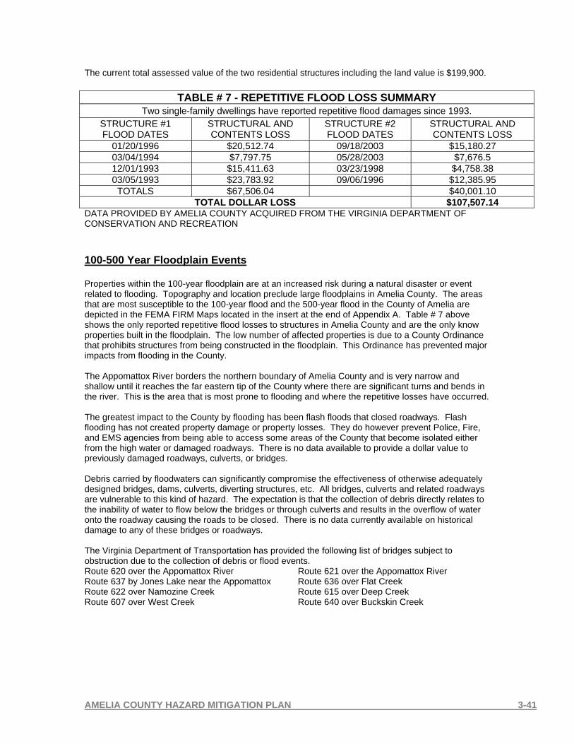
AMELIA COUNTY HAZARD MITIGATION PLAN 3-41
The current total assessed value of the two residential structures including the land value is $199,900.
TABLE # 7 - REPETITIVE FLOOD LOSS SUMMARY Two single-family dwellings have reported repetitive flood damages since 1993.
STRUCTURE #1 FLOOD DATES
STRUCTURAL AND CONTENTS LOSS
STRUCTURE #2 FLOOD DATES
STRUCTURAL AND CONTENTS LOSS
01/20/1996 $20,512.74 09/18/2003 $15,180.27 03/04/1994 $7,797.75 05/28/2003 $7,676.5 12/01/1993 $15,411.63 03/23/1998 $4,758.38 03/05/1993 $23,783.92 09/06/1996 $12,385.95
TOTALS $67,506.04 $40,001.10 TOTAL DOLLAR LOSS $107,507.14
DATA PROVIDED BY AMELIA COUNTY ACQUIRED FROM THE VIRGINIA DEPARTMENT OF CONSERVATION AND RECREATION 100-500 Year Floodplain Events Properties within the 100-year floodplain are at an increased risk during a natural disaster or event related to flooding. Topography and location preclude large floodplains in Amelia County. The areas that are most susceptible to the 100-year flood and the 500-year flood in the County of Amelia are depicted in the FEMA FIRM Maps located in the insert at the end of Appendix A. Table # 7 above shows the only reported repetitive flood losses to structures in Amelia County and are the only know properties built in the floodplain. The low number of affected properties is due to a County Ordinance that prohibits structures from being constructed in the floodplain. This Ordinance has prevented major impacts from flooding in the County. The Appomattox River borders the northern boundary of Amelia County and is very narrow and shallow until it reaches the far eastern tip of the County where there are significant turns and bends in the river. This is the area that is most prone to flooding and where the repetitive losses have occurred. The greatest impact to the County by flooding has been flash floods that closed roadways. Flash flooding has not created property damage or property losses. They do however prevent Police, Fire, and EMS agencies from being able to access some areas of the County that become isolated either from the high water or damaged roadways. There is no data available to provide a dollar value to previously damaged roadways, culverts, or bridges. Debris carried by floodwaters can significantly compromise the effectiveness of otherwise adequately designed bridges, dams, culverts, diverting structures, etc. All bridges, culverts and related roadways are vulnerable to this kind of hazard. The expectation is that the collection of debris directly relates to the inability of water to flow below the bridges or through culverts and results in the overflow of water onto the roadway causing the roads to be closed. There is no data currently available on historical damage to any of these bridges or roadways. The Virginia Department of Transportation has provided the following list of bridges subject to obstruction due to the collection of debris or flood events. Route 620 over the Appomattox River Route 621 over the Appomattox River Route 637 by Jones Lake near the Appomattox Route 636 over Flat Creek Route 622 over Namozine Creek Route 615 over Deep Creek Route 607 over West Creek Route 640 over Buckskin Creek

AMELIA COUNTY HAZARD MITIGATION PLAN 3-42
Dam Breach and Failure There have been no reported dam failures in Amelia County. Several dams have overflowed during periods of heavy rain with only one report of damage. The earthen dam on a farm pond at the end of Harris Street, Route 700, was damaged by overflow as a result of the 5.18 inches of rain that fell as a result of Tropical Storm Isabel. There is no threat to life or structures if this dam were to fail. There is a probability of rain and pond water entering two County wells located below the dam. There are no High Hazard or Significant Hazard dams in Amelia County. It can be concluded that dam failure or overflow does not provide the potential for loss of life or property. The map below shows that Amelia County has a number of Low Hazard dams and no Moderate or High Hazards dams. They are mostly low height, earthen dams on low flow creeks or ponds. The failure of any of these dams does not create the potential to loss of property or loss of life. MAP 8 – MAP OF DAMS IN AMELIA COUNTY AND ADJOINING JURISDICTIONS
MAP PROVIDE BY THE NATIONAL INVENTORY OF DAMS THROUGH THE ARMY CORPS OF ENGINEERS Dams function to serve the needs of flood control, recreation, wildlife enhancement and water resources management. During severe weather events, such as a flood, a dam’s ability to serve as a flood control mechanism may be challenged and could breach or fail. In this event, anything downstream of a dam is in danger. Two dams in Amelia County were considered for the potential damage due to dam failure. If failed, the dam at Steve Davis’s farm pond would flood farm land and cause crop damage that can not be estimated in cost. It also has the potential of contaminating a county well that serves as a local water source. Alternative water sources are available if this occurs. The second dam considered is located on Route 53 at The Old Mill on Beaverpond Creek. The results
DAM HAZARD CLASSIFICATIONS
HIGH HAZARD
SIGNIFICANT HAZARD
LOW HAZARD
ALL AMELIA COUNTY DAMS ARE LOW HAZARD DAMS AND ALL SHOWN
ON THIS MAP ARE LOCATED ON CREEKS.
DAMS IN ADJOINING JURISDICTIONS ARE INCLUDED TO SHOW
THEY DO NOT POSE A THREAT TO AMELIA
COUNTY

AMELIA COUNTY HAZARD MITIGATION PLAN 3-43
would be road flooding and closure. There are no expected structural damage costs due to failures of either of these dams.

AMELIA COUNTY HAZARD MITIGATION PLAN 3-44
3-3.2 HURRICANES AND TROPICAL STORMS DESCRIPTION The ingredients for a hurricane include a pre-existing weather disturbance, warm tropical oceans, moisture, and relatively light winds aloft. If the right conditions persist long enough, they can combine to produce the violent winds, incredible waves, torrential rains, and floods we associate with this phenomenon. Each year, averages of ten tropical storms develop over the Atlantic Ocean, Caribbean Sea, and Gulf of Mexico. Many of these remain over the ocean and never impact the U.S. coastline. Six of these storms become hurricanes each year. In an average 3-year period, roughly five hurricanes strike the US coastline, killing approximately 50 to 100 people anywhere from Texas to Maine. Of these, two are typically "major" or "intense" hurricanes (a category 3 or higher storm on the Saffir-Simpson Hurricane Scale). A hurricane is a type of tropical cyclone, which is a generic term for a low pressure system that generally forms in the tropics. The cyclone is accompanied by thunderstorms and, in the Northern Hemisphere, a counterclockwise circulation of winds near the earth's surface. Tropical cyclones are classified as follows: Tropical Depression An organized system of clouds and thunderstorms with a defined surface circulation and maximum sustained winds* of 38 mph (33 kt**) or less
Tropical Storm An organized system of strong thunderstorms with a defined surface circulation and maximum sustained winds of 39-73 mph (34-63 kt)
A hurricane is an intense tropical weather system of strong thunderstorms with a well-defined surface circulation and maximum sustained winds of 74 mph (64 kt) or higher. Hurricanes are categorized according to the strength of their winds using the Saffir-Simpson Hurricane Scale. A Category 1 storm has the lowest wind speeds, while a Category 5 hurricane has the strongest. These are relative terms, because lower category storms can sometimes inflict greater damage than higher category storms, depending on where they strike and the particular hazards they bring. In fact, tropical storms can also produce significant damage and loss of life, mainly due to flooding. A hurricane is a tropical cyclone in which winds reach speeds of 74 miles per hour or more and blow in a large spiral around a relatively calm center. The eye of the storm is usually 20-30 miles wide and may extend over 400 miles. The dangers of the storm include torrential rains, high winds and storm surges. It produces measurable damage from heavy rainfalls, winds, and floods. High winds are a primary cause of hurricane-inflicted loss of life and property damage. Another cause is the flooding resulting from the coastal storm surge of the ocean and the torrential rains, both of which accompany the storm. A hurricane watch is issued when there is a threat of hurricane conditions within 24-36 hours. A hurricane warning is issued when hurricane conditions (winds greater than 74 mph/119 kph or dangerously high water and rough seas) are expected in 24 hours or less. SAFFIR/SIMPSON HURRICANE SCALE This scale was developed in an effort to estimate the possible damage a hurricane's sustained winds and storm surge could do to a coastal area. The scale of numbers is based on actual conditions at some time during the life of the storm. As the hurricane intensifies or weakens, the scale number is reassessed accordingly. The following table shows the scale broken down by central pressure, winds, and storm surge:
* Sustained winds A 1-minute average wind measured at about 33 ft (10 meters) above the surface.
** 1 knot = 1 nautical mile per hour or 1.15 statute miles per hour. Abbreviated as "kt".

AMELIA COUNTY HAZARD MITIGATION PLAN 3-45
This information was provided by The National Hurricane Center and can be used to give an estimate of the potential property damage and flooding expected along the coast with a hurricane. SAFFIR/SIMPSON HURRICANE SCALE
Category Definition Effects
One Winds 74-95
mph No real damage to building structures. Damage primarily to unanchored mobile homes, shrubbery, and trees. Also, some coastal road flooding and minor pier damage
Two Winds 96-110
mph
Some roofing material, door, and window damage to buildings. Considerable damage to vegetation, mobile homes, and piers. Coastal and low-lying escape routes flood 2-4 hours before arrival of center. Small craft in unprotected anchorages break moorings.
Three Winds 111-130
mph
Some structural damage to small residences and utility buildings with a minor amount of curtain wall failures. Mobile homes are destroyed. Flooding near the coast destroys smaller structures with larger structures damaged by floating debris. Terrain continuously lower than 5 feet ASL may be flooded inland 8 miles or more.
Four Winds 131-155
mph
More extensive curtain wall failures with some complete roof structure failure on small residences. Major erosion of beach. Major damage to lower floors of structures near the shore. Terrain continuously lower than 10 feet ASL may be flooded requiring massive evacuation of residential areas inland as far as 6 miles.
Five Winds greater than 155 mph
Complete roof failure on many residences and industrial buildings. Some complete building failures with small utility buildings blown over or away. Major damage to lower floors of all structures located less than 15 feet ASL and within 500 yards of the shoreline. Massive evacuation of residential areas on low ground within 5 to 10 miles of the shoreline may be required.
Above information can be found at: http://www.fema.gov/hazards/hurricanes/saffir.shtm
AMELIA COUNTY HAZARD MITIGATION PLAN 3-46
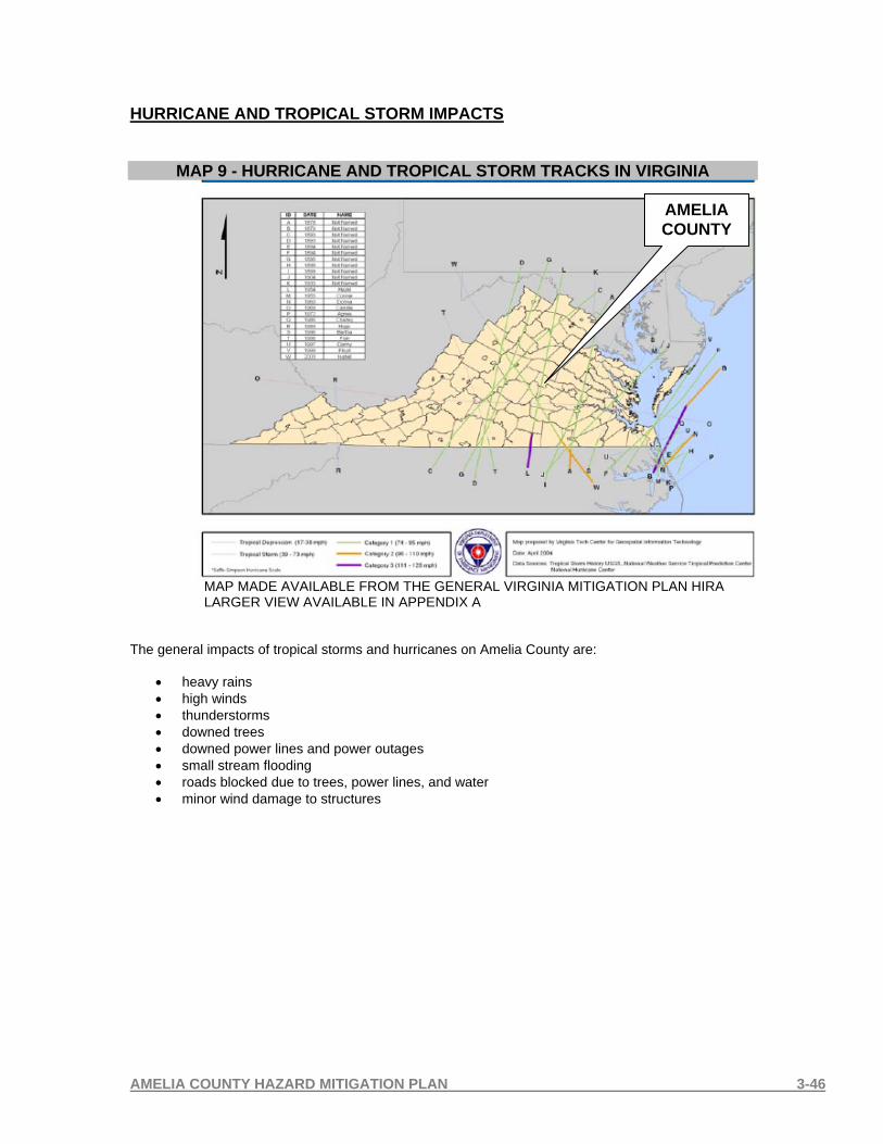
HURRICANE AND TROPICAL STORM IMPACTS
MAP 9 - HURRICANE AND TROPICAL STORM TRACKS IN VIRGINIA
MAP MADE AVAILABLE FROM THE GENERAL VIRGINIA MITIGATION PLAN HIRA LARGER VIEW AVAILABLE IN APPENDIX A
The general impacts of tropical storms and hurricanes on Amelia County are:
• heavy rains • high winds • thunderstorms • downed trees • downed power lines and power outages • small stream flooding • roads blocked due to trees, power lines, and water • minor wind damage to structures
AMELIA COUNTY

AMELIA COUNTY HAZARD MITIGATION PLAN 3-47
HURRICANE HAZEL 10/15/54 There is no specific data available on the direct impact of Hurricane Hazel on Amelia County either through the National Weather Service or the Hazard Mitigation Planning Committee. This is largely due to the 1954 date of occurrence. There is general information available from NOAA. There are no known reported deaths or injuries due to this event. THE NATIONAL HURRICANE CENTER REPORTED: High winds occurred over large portions of the eastern United States. Myrtle Beach, South Carolina reported a peak wind gust of 106 mph, and winds were estimated at 130 to 150 mph along the coast between Myrtle Beach and Cape Fear, North Carolina. Washington, DC reported 78 mph sustained winds, and peak gusts of over 90 mph occurred as far northward as inland New York State. A storm surge of up to 18 ft inundated portions of the North Carolina coast. Heavy rains of up to 11 inches occurred as far northward as Toronto, Canada resulting in severe flooding.
MAP 10 - HURRICANE HAZEL 10/15/1954
MAP PROVIDED BY NOAA COASTAL SERVICES CENTER

AMELIA COUNTY HAZARD MITIGATION PLAN 3-48
HURRICANE CAMILLE 08/17/1969 There is no specific data available on the direct impact of Hurricane Camille on Amelia County either through the National Weather Service or the Hazard Mitigation Planning Committee. This is largely due to the 1969 date of occurrence. There is general information available from NOAA. There are no known reported deaths or injuries due to this event. THE NATIONAL HURRICANE CENTER REPORTED: A minimum pressure of 26.84 inches was reported in Bay St. Louis, Mississippi, which makes Camille the second most intense hurricane of record to hit the United States. The actual maximum sustained winds will never be known, as the hurricane destroyed all the wind-recording instruments in the landfall area. The estimates at the coast are near 200 mph. Columbia, Mississippi, located 75 miles inland, reported 120 mph sustained winds. A storm tide of 24.6 ft occurred at Pass Christian, Mississippi. The heaviest rains along the Gulf Coast were about 10 inches. However, as Camille passed over the Virginias, it produced a burst of 12 to 20 inch rains with local totals of up to 31 inches. Most of this rain occurred in 3 to 5 hours and caused catastrophic flash flooding.
MAP 11 - HURRICANE CAMILLE 08/17/1969
MAP PROVIDED BY NOAA COASTAL SERVICES CENTER

AMELIA COUNTY HAZARD MITIGATION PLAN 3-49
TROPICAL STORM ISABEL There are no reported deaths or injuries in Amelia County due to this event. Amelia County reported 5.18 inches of rain from 09/18/2003 through 09/19/2003 accompanied by high winds. The high winds in combination with rain saturated ground caused some trees to be uprooted or broken off but not to a significant extent. Power poles and power lines were downed causing numerous power outages for periods that ranged from 2-5 days. A minimal amount of roadways were blocked by power lines or trees and several were covered with overflowing creeks.
Route 616, Genito Road ½ mile west of Redmore Lane, washed away when a stream running off of Walker Branch washed over and around the culvert pipe. The red circle on the photo indicates the location on Route 616 that was damaged.
The earthen dam on a farm pond at the end of Harris Street, Route 700, overflowed and caused some areas of the dam to wash out. The dam is shown on this picture in red.

AMELIA COUNTY HAZARD MITIGATION PLAN 3-50
THE NATIONAL HURRICANE CENTER REPORTED: Although weakening, Isabel’s wind field continued to expand as hurricane warnings were issued for most of the North Carolina and Virginia coastline, including the Chesapeake Bay. Isabel’s large eye pushed ashore just after the noon hour on September 18th near Drum Inlet along North Carolina’s Outer Banks. Isabel was the worst hurricane to affect the Chesapeake Bay region since 1933. Storm surge values of more than 8 feet flooded rivers that flowed into the Bay across Virginia, Maryland, Delaware, and Washington, D.C. Isabel brought tropical storm force gusts as far north as New York State as it moved inland. The most intense hurricane of the 2003 season directly resulted in 17 deaths and more than 3 billion dollars in damages. The large wind field toppled trees and cut power to more than four million customers.
MAP 12 - TROPICAL STORM ISABEL 09/18/2003
MAP PROVIDED BY NOAA COASTAL SERVICES CENTER

AMELIA COUNTY HAZARD MITIGATION PLAN 3-51

AMELIA COUNTY HAZARD MITIGATION PLAN 3-52
NCDC EVENT RECORD FOR TROPICAL STORM ISABEL Event: Tropical Storm
Begin Date: 18 Sep 2003, 09:00:00 AM EST Begin Location: Not Known
End Date: 19 Sep 2003, 04:00:00 AM EST End Location: Not Known
Magnitude: 0 Fatalities: 3
Injuries: 0 Property
Damage: $ 45.1M
Crop Damage: $ 7.1M
State: Virginia Forecast
Zonesaffected:
Amelia, Brunswick, Caroline, Chesterfield, Cumberland, Dinwiddie, Fluvanna, Goochland, Hanover, Henrico, King And Queen, King William, Louisa, Lunenburg, Mecklenburg, Nottoway, Powhatan, Prince Edward
Description: Tropical Storm Isabel produced tropical storm force sustained winds and wind gusts over the piedmont of central and south central Virginia, as it crossed the Wakefield WFO county warning area. Isabel made landfall near Ocracoke Inlet in North Carolina, tracked northwest into central Virginia just west of Richmond, then continued northward into western Pennsylvania. The highest sustained wind speed recorded was 38 mph at Richmond International Airport. The highest gusts recorded were 73 mph at Richmond International Airport, 63 mph at WWBT-TV, and 53 mph at Chase City in Mecklenburg county. Approximately several thousand persons were evacuated and housed in numerous shelters across the piedmont of central and south central Virginia. The unusually large wind field uprooted many thousands of trees, downed many power lines, damaged hundreds of houses, and snapped thousands of telephone poles and cross arms. Hundreds of roads, including major highways, were blocked by fallen trees. Over 2 million customers of Dominion Virginia Power were without electricity. Local electrical cooperatives also reported thousands of customers were without power. The lowest sea level pressure recorded was 987 mb at Portsmouth Virginia. Isabel will be remembered for the greatest wind and storm surge in the region since Hazel in 1954, and the 1933 Chesapeake-Potomac Hurricane. Also, Isabel will be remembered for the most extensive power outages ever in Virginia, and permanent change to the landscape from all the fallen trees and storm surge. Rainfall amounts ranged from 4 to 7 inches across the piedmont of central and south central Virginia. Inland flooding due to heavy rainfall occurred over parts of the piedmont of central and south central Virginia. High water was reported around Swift Creek in Colonial Heights around Pinehurst Drive. Some areas in Chesterfield county, such as Beach road also had high water. Eight deaths can be directly attributed to Isabel in the Wakefield area of responsibility, with 7 in Virginia. There were more than 15 deaths indirectly attributed to the storm. M27OU, M54IW, F45PH 3-3.3 TORNADOES DESCRIPTION Tornadoes are one of nature's most violent storms. In an average year, about 1,000 tornadoes are reported across the United States, resulting in 80 deaths and over 1,500 injuries. A tornado is a violently rotating column of air extending from a thunderstorm to the ground. The most violent tornadoes are capable of tremendous destruction with wind speeds of 250 mph or more. Damage paths can be in excess of one mile wide and 50 miles long. Tornadoes come in all shapes and sizes and can occur anywhere in the U.S. at any time of the year. In the southern states, peak tornado season is March through May, while peak months in the northern states are during the summer. Thunderstorms develop in warm, moist air in advance of eastward-moving cold fronts. These thunderstorms often produce large hail, strong winds, and tornadoes. Tornadoes in the winter and early spring are often associated with strong, frontal systems that form in the Central States and move

AMELIA COUNTY HAZARD MITIGATION PLAN 3-53
east. Occasionally, large outbreaks of tornadoes occur with this type of weather pattern. Several states may be affected by numerous severe thunderstorms and tornadoes. During the spring and summer months, thunderstorms frequently develop along a "dryline," which separates very warm, moist air to the east from hot, dry air to the west. Tornado-producing thunderstorms may form as the dryline moves east during the afternoon hours. Thunderstorms frequently form as air near the ground flows "upslope" toward higher terrain. If other favorable conditions exist, these thunderstorms can produce tornadoes. Tornadoes occasionally accompany tropical storms and hurricanes that move over land. Tornado intensity is measured by wind speed and categorized by the Fujita Scale. (SOURCE: NATIONAL WEATHER SERVICE) Fujita Scale A scale of tornado intensity in which wind speeds are inferred from an analysis of wind damage:
Rating Wind, Damage F0 (weak) 40-72 mph, light damage F1 (weak) 73-112 mph, moderate damage F2 (strong) 113-157 mph, considerable damage F3 (strong) 158-206 mph, severe damage F4 (violent) 207-260 mph, devastating damage F5 (violent) 260-318 mph (rare), incredible damage
Source: National Weather Service TORNADO IMPACTS The Commonwealth of Virginia General Mitigation Plan ranks Amelia County as the 24th highest ranked locality in its Vulnerability Assessment of 136 localities. There have been (7) seven tornadoes reported to the NCDC in Amelia County since 1983. These tornadoes ranged in magnitude from F0 to F3. F1 was the most common which occurred four times. Damage to property by these events has been confirmed by the Planning Committee at approximately $562,000 and not the damage recorded by the NCDC. Data obtained from The Virginia Department of Emergency Management verifies that Amelia County was not damaged by this tornado: May 4, 1990: At around 7:30 pm on a Friday evening, a F2 tornado cut through the heart of the small town of Augusta Springs southwest of Staunton in Augusta County. It destroyed five buildings and damaged almost all of the others in town. Seven people were injured and others lost everything they had. The tornado was on the ground for about a mile. It lifted as the storm passed over a 2500 foot mountain. On the other side, another tornado touched down in Swoope cutting across cow pasture and striking a mobile home. Two men were killed and two women injured in the mobile home. A young boy was asleep in the camper cab on a truck parked next to the trailer. The truck was thrown and he was injured. Pieces of the home site were strewn for over a mile across fields. In Chesterfield County, a F2 tornado touched down and tracked about 5 miles doing significant damage to 22 homes. Heavy rains, extremely strong winds and hail up to the size of golf balls accompanied the storm. About 15 minutes later, another strong tornado produced by the same storm struck Colonial Heights damaging a number of business along I-95. It hit the Wal-Mart (now a Sam's Club) at Southpark Mall. The same Wal-Mart that was later demolished by a tornado in 1993. There have been 2 injuries as a result of a mobile home being overturned. The Amelia Mitigation Planning Committee has provided data and information that is more accurate and is included in the

AMELIA COUNTY HAZARD MITIGATION PLAN 3-54
next pages with each individual event report. Damage caused by tornadoes has been historically minor in Amelia County however the potential for damage to all structures and essential facilities exists. The damage could range from minor to total devastation and could result in injuries and loss of life one tornado demonstrated by touching ground at an Amelia County School. Critical infrastructures, communication systems, and Public Safety resources are extremely vulnerable to the tornado events.

AMELIA COUNTY HAZARD MITIGATION PLAN 3-55
HISTORICAL TORNADO EVENTS AS REPORTED TO THE NCDC Location or County Date Time Type Mag Dth Inj PrD CrD
1 AMELIA 10/13/1983 1450 Tornado F1 0 0 250K 0
2 AMELIA 11/16/1989 0715 Tornado F0 0 0 250K 0
3 AMELIA 05/04/1990 1945 Tornado F3 0 0 2.5M* 0
4 Amelia 05/09/2003 02:35 PM Tornado F1 0 0 25K 0
5 Amelia 09/23/2003 04:30 AM Tornado F1 0 2 25K 0
6 Truxillo 09/08/2004 04:40 PM Tornado F0 0 0 2K 0
7 Mannboro 09/17/2004 03:08 PM Tornado F1 0 0 10K 0
TOTALS: 0 2 3.062M*
* This tornado did not result in damage to Amelia County. Damage totals should be recorded as $562,000.
1.1.5 Event 1 Record Details
Event: Tornado Begin Date: 13 Oct 1983, 1450 CST
Begin Location: Not Known Begin LAT/LON: 37°18'N / 78°12'W
End Location: Not Known End LAT/LON: 37°18'N / 78°09'W
Length: 2 Miles Width: 30 Yards
Magnitude: F1 Fatalities: 0
Injuries: 0 Property Damage: $ 250.0K
Crop Damage: $ 0.0 Description: None Reported EVENT 1 IMPACT: The Planning Committee reports that the only know damage from this tornado was numerous trees and power lines downed by the tornado and associated winds. Based on the Planning Committee’s knowledge of the event, they believe the reported $250,000 damage to property to be inaccurate.

AMELIA COUNTY HAZARD MITIGATION PLAN 3-56
Event 2 Record Details Event: Tornado
Begin Date: 16 Nov 1989, 0715 CST Begin Location: Not Known
Begin LAT/LON: 37°20'N / 77°56'W End Location: Not Known
Length: 0 Mile Width: 13 Yards
Magnitude: F0 Fatalities: 0
Injuries: 0 Property Damage: $ 250.0K
Crop Damage: $ 0.0 Description: None Reported EVENT 2 IMPACT: The Planning Committee reports that the only know damage from this tornado was numerous trees and power lines downed by the tornado and associated winds and believe the reported $250,000 property damage to be inaccurate.
Event 3 Record Details Event: Tornado
Begin Date: 04 May 1990, 1945 EDT Begin Location: Not Known
Begin LAT/LON: 37°19'N / 77°49'W End Location: Not Known
End LAT/LON: 37°14'N / 77°25'W Length: 8 Miles Width: 500 Yards
Magnitude: F3 Fatalities: 0
Injuries: 0 Property Damage: $ 2.5M
Crop Damage: $ 0.0 Description: None Reported
EVENT 3 IMPACT: The Planning Committee reports that this tornado actually tracked downstream along the Appomattox River into Chesterfield County. The locations provided by the NCDC verify this information. The Virginia Department of Emergency Management Tornado History records also verify that the following occurred: May 4, 1990: At around 7:30 pm on a Friday evening, a F2 tornado cut through the heart of the small town of Augusta Springs southwest of Staunton in Augusta County. It destroyed five buildings and damage almost all of the others in town. Seven people were injured and others lost everything they had. The tornado was on the ground for about a mile. It lifted as the storm passed over a 2500 foot mountain. On the other side, another tornado touched down in Swoope

AMELIA COUNTY HAZARD MITIGATION PLAN 3-57
cutting across cow pasture and striking a mobile home. Two men were killed and two women injured in the mobile home. A young boy was asleep in the camper cab on a truck parked next to the trailer. The truck was thrown and he was injured. Pieces of the home site were strewn for over a mile across fields.
In Chesterfield County, a F2 tornado touched down and tracked about 5 miles doing significant damage to 22 homes. Heavy rains, extremely strong winds and hail up to the size of golf balls accompanied the storm. About 15 minutes later, another strong tornado produced by the same storm struck Colonial Heights damaging a number of business along I-95. It hit the Wal-Mart (now a Sam's Club) at Southpark Mall. The same Wal-Mart that was later demolished by a tornado in 1993.
Event 4 Record Details Event: Tornado
Begin Date: 09 May 2003, 02:35:00 PM EST Begin Location: 1 Mile North East of Amelia
Begin LAT/LON: 37°20'N / 77°59'W End Date: 09 May 2003, 02:40:00 PM EST
End Location: 3 Miles South East of Amelia End LAT/LON: 37°18'N / 77°57'W
Length: 3 Miles Width: 200 Yards
Magnitude: F1 Fatalities: 0
Injuries: 0 Property Damage: $ 25.0K
Crop Damage: $ 0.0 Description: Widespread major damage to trees and power lines, along with some structural damage by F1 tornado in Amelia county. One farm near the end of the tornado path suffered major damage to several barns and outbuildings. EVENT 4 IMPACT: The Planning Committee has verified the damage indicated in the description above is accurate.

AMELIA COUNTY HAZARD MITIGATION PLAN 3-58
Event 5 Record Details Event: Tornado
Begin Date: 23 Sep 2003, 04:30:00 AM EST Begin Location: 4 Miles South of Amelia
Begin LAT/LON: 37°17'N / 77°59'W End Date: 23 Sep 2003, 04:30:00 AM EST
End Location: 4 Miles South West of Amelia End LAT/LON: 37°17'N / 77°59'W
Length: 2 Miles Width: 100 Yards
Magnitude: F1 Fatalities: 0
Injuries: 2 Property Damage: $ 25.0K
Crop Damage: $ 0.0 Description: F1 tornado on Route 614. Barn destroyed. Mobile home also destroyed and overturned several times. EVENT 5 IMPACT: The Planning Committee has verified the description above as accurate including the 2 injuries reported to occupants of the mobile home that overturned.

AMELIA COUNTY HAZARD MITIGATION PLAN 3-59
Event 6 Record Details Event: Tornado
Begin Date: 08 Sep 2004, 04:40:00 PM EST Begin Location: Truxillo
Begin LAT/LON: 37°22'N / 78°02'W End Date: 08 Sep 2004, 04:40:00 PM EST
End Location: Truxillo End LAT/LON: 37°22'N / 78°02'W
Length: 1 Mile Width: 50 Yards
Magnitude: F0 Fatalities: 0
Injuries: 0 Property Damage: $ 2.0K
Crop Damage: $ 0.0 Description: F0 tornado twisted off tree tops near intersection of Routes 639 and 681. EVENT 6 IMPACT: The Planning Committee has verified the damage indicated in the description above is accurate.
Event 7 Record Details
Event: Tornado Begin Date: 17 Sep 2004, 03:08:00 PM EST
Begin Location: Mannboro Begin LAT/LON: 37°15'N / 77°50'W
End Date: 17 Sep 2004, 03:10:00 PM EST End Location: Mannboro
End LAT/LON: 37°15'N / 77°50'W Length: 2 Miles Width: 60 Yards
Magnitude: F1 Fatalities: 0
Injuries: 0 Property Damage: $ 10.0K
Crop Damage: $ 0.0
Description: F1 tornado blew roof off garage and lifted garage off foundation. Trees down with some snapped off in wooded area.
EVENT 7 IMPACT: The Planning Committee has verified the damage indicated in the description above is accurate.

AMELIA COUNTY HAZARD MITIGATION PLAN 3- 60
MAP 13 - LOCATIONS OF REPORTED TORNADOS FROM 1983 TO 2004
Location data provided by the NCDC and the Amelia Mitigation Planning Committee A map showing exact locations is available in Appendix A in a larger format.

AMELIA COUNTY HAZARD MITIGATION PLAN 3-61
Adjoining jurisdictions to Amelia County have reported numerous tornados that are an indicator of the vulnerability of the general geographic area. Reported tornados in the adjoining jurisdictions include: TABLE #8 - REPORTED TORNADOS TO SURROUNDING JURISDICTIONS
LOCALITY NUMBER OF TORNADOS
Chesterfield County 13
Nottoway County 11
Dinwiddie County 7
Prince Edward County 1
Powhatan County 1
Cumberland County 1
SOURCE: NATIONAL CLIMATIC DATA CENTER

AMELIA COUNTY HAZARD MITIGATION PLAN 3-62
3-3.4 THUNDERSTORMS AND HIGH WINDS DESCRIPTION There are three types of thunderstorms: Single-cell (or air mass) Multi-cell cluster, Multi-cell (or squall line) Super-cell The air mass thunderstorm is a common and usually non-severe phenomenon that forms away from frontal systems or other synoptic-scale disturbances. They form where moist and unstable conditions exist in the atmosphere. Air mass thunderstorms are usually produced in areas of very little vertical shear. As a result, the threat for severe is small. When they do reach severe limits, the thunderstorms may produce brief high winds or hail which develop because of high instability. These storms are known as pulse severe storms. Although several storm cells can develop, each individual cell lasts about 30-60 minutes and has three stages. Cumulus Stage:
• Starts with a warm plume of rising air. • The updraft velocity increases with height. • Entrainment pulls outside air into the cloud. • Supercooled water droplets are carried far above freezing level.
Mature Stage: • The heaviest rains occur. • The downdraft is initiated by frictional drag of the raindrops. • Evaporative cooling leads to negative buoyancy. • The top of the cloud approaches tropopause and forms anvil top.
Dissipating Stage: • The downdraft takes over entire cloud. • The storm deprives itself of supersaturated updraft air. • Precipitation decreases. • The cloud evaporates.
As wind shear organizes the convection, new thunderstorms form as a result of parent thunderstorm outflows converging with warm, moist inflow creating new updrafts. Multi-cell storms can form in a line known as a squall line, where continuous updrafts form along the leading edge of the outflow, or gust front. Multi-cell clusters indicate new updrafts are forming where the low-level convergence is strongest, usually at the right, or right-rear flank of existing cells. Thunderstorms that organize in response to synoptic scale forcing usually need: - warm, moist air at low levels - cool, dry air at upper levels - upper-level divergence (above 500mb) - a synoptic scale disturbance In these conditions, thunderstorm formation is probable. Synoptic scale vertical motions tend to create favorable conditions for thunderstorms, but thunderstorm initiation is usually a result of mesoscale forcing. Increasingly favorable vertical wind profiles may lead to a greater possibility of supercell development rather than multicell storms. The development of squall lines, or more commonly storm clusters, when thunderstorms do develop is virtually guaranteed in association with synoptic scale forcing. Multicellular storms consist of a series of evolving cells. At low levels, cooler air diverging from the downdraft intersects the inflowing air along a gust front, creating a region of strong low- level convergence favorable for new updrafts. It is the presence of vertical wind shear that results in the "tilting" of the updraft and downdraft. Because of the tilting, the less buoyant downdraft air will not destroy the updraft and hence deprive itself up supersaturated

AMELIA COUNTY HAZARD MITIGATION PLAN 3-63
updraft air. In any case, the movement of multicell storms systems is determined by combining the new cell development with the mean winds. Each individual cell typically moves with the mean winds, while new cells develop where the inflow meets the outflow, hence, in the region of strongest surface, or low-level, convergence. Supercells are the most powerful thunderstorms. By their definition, supercells are always severe. Supercells are responsible for a disproportionate amount of damage and casualties. The most significant difference arises from the presence of a rotating updraft, or mesocyclone. These features insure the longevity of a thunderstorm by allowing the flanking line to enhance the inflow into one main updraft, rather than helping create new updraft centers. The combination of rotation and longevity increase the chances for the development of strong or violent tornadoes. (SOURCE: NEXT GENERATION WEATHER LAB, College of DuPage Glen Ellyn, IL) High winds can be classified utilizing the Beaufort Scale:
Force Wind Speed (kts) Description 0 0 Calm 1 1 - 3 Light Air 2 4 - 6 Light Breeze 3 7 - 10 Gentle Breeze 4 11 - 16 Moderate Breeze 5 17 - 21 Fresh Breeze 6 22 - 27 Strong Breeze 7 28 - 33 Near Gale 8 34 - 40 Gale 9 41 - 47 Strong Gale
10 48 - 55 Storm 11 56 - 63 Violent Storm 12 64+ Hurricane
Source: National Weather Service THUNDERSTORM AND HIGH WIND IMPACTS Thunderstorms produce heavy rains, strong winds, and lightning. Damage normally caused by these storms in Amelia County is minor flash flooding, downed trees, downed power lines, and lightning strikes that may cause fires. Injuries to people and damage to buildings are likely results of lightning. The details of lightning events are covered in Section 3-3.5 following the impacts of thunderstorm events. The NCDC has (47) thunderstorm and high wind events on record reported by Amelia County. There are no injuries or deaths attributed to thunderstorms however there has been $87,000 in property damage reported due to the high winds or hail during thunderstorm events. Winds have been recorded as high as 61 knots. As the County continues to experience growth in residential, commercial, and industrial areas, the impact of severe storms and high wind will increase. At this time, the largely rural geographic profile of Amelia County reduces the impact of severe weather of this type.

AMELIA COUNTY HAZARD MITIGATION PLAN 3-64
HISTORICAL OCCURANCES Location or County Date Time Type Mag Dth Inj PrD CrD
1 AMELIA 03/24/1975 1345 Tstm Wind 0 kts. 0 0 0 0
2 AMELIA 01/21/1979 0030 Tstm Wind 0 kts. 0 0 0 0
3 AMELIA 10/06/1981 1715 Tstm Wind 0 kts. 0 0 0 0
4 AMELIA 06/16/1985 1530 Tstm Wind 0 kts. 0 0 0 0
5 AMELIA 05/06/1989 1350 Tstm Wind 52 kts. 0 0 0 0
6 AMELIA 06/02/1989 1540 Tstm Wind 0 kts. 0 0 0 0
7 AMELIA 06/13/1989 1322 Tstm Wind 52 kts. 0 0 0 0
8 AMELIA 05/04/1990 1735 Tstm Wind 0 kts. 0 0 0 0
9 AMELIA 09/07/1990 1450 Tstm Wind 0 kts. 0 0 0 0
10 AMELIA 08/31/1991 1800 Tstm Wind 0 kts. 0 0 0 0
11 AMELIA 03/10/1992 1342 Tstm Wind 61 kts. 0 0 0 0
12 AMELIA 07/31/1992 1500 Tstm Wind 0 kts. 0 0 0 0
13 AMELIA 07/31/1992 1515 Tstm Wind 0 kts. 0 0 0 0
14 Amelia 06/03/1995 1830 Thunderstorm Winds N/A 0 0 0 0
15 AMELIA 06/11/1995 1945 Thunderstorm Winds N/A 0 0 0 0
16 Mannboro 07/11/1995 0200 Thunderstorm Winds N/A 0 0 0 0
17 Near Amelia 11/11/1995 1845 Thunderstorm Winds N/A 0 0 0 0
18 Amelia 01/19/1996 09:10 AM Tstm Wind 0 kts. 0 0 0 0
19 Chula 04/23/1996 06:10 PM Tstm Wind 0 kts. 0 0 0 0
20 Countywide 04/29/1996 07:10 PM Tstm Wind 0 kts. 0 0 0 0
21 Amelia 05/11/1996 05:00 PM Tstm Wind 0 kts. 0 0 5K 0
22 Scotts Fork 05/11/1996 05:05 PM Tstm Wind 0 kts. 0 0 4K 0
23 Jetersville 06/24/1996 06:47 PM Tstm Wind 0 kts. 0 0 3K 0
24 Wilsons Corner 07/15/1996 03:25 PM Tstm Wind 0 kts. 0 0 15K 0
25 Amelia 11/08/1996 02:35 PM Tstm Wind 0 kts. 0 0 2K 0
26 Countywide 06/26/1997 06:08 PM Tstm Wind 0 kts. 0 0 2K 0
27 Amelia 07/04/1997 08:55 PM Tstm Wind 0 kts. 0 0 3K 0
28 Amelia 06/13/1998 02:35 PM Tstm Wind 0 kts. 0 0 2K 0
29 Mannboro 06/16/1998 05:00 PM Tstm Wind 0 kts. 0 0 2K 0
30 Amelia 04/09/1999 06:45 PM Tstm Wind 0 kts. 0 0 2K 0
31 Masons Corner 07/07/1999 03:55 PM Tstm Wind 0 kts. 0 0 2K 0
32 Chula 07/29/1999 04:56 PM Tstm Wind 0 kts. 0 0 1K 0
33 Amelia 09/30/1999 12:10 AM Tstm Wind 0 kts. 0 0 5K 0

AMELIA COUNTY HAZARD MITIGATION PLAN 3-65
34 Rodephil 03/11/2000 08:15 PM Tstm Wind 0 kts. 0 0 2K 0
35 Amelia 05/20/2000 02:45 PM Tstm Wind/hail 0 kts. 0 0 10K 0
36 Wilsons Corner 08/09/2000 04:50 PM Tstm Wind 50 kts. 0 0 1K 0
37 Amelia 09/14/2000 07:00 PM Tstm Wind 50 kts. 0 0 5K 0
38 Earls 05/02/2002 03:05 PM Tstm Wind 0 kts. 0 0 3K 0
39 Amelia 05/09/2003 02:40 PM Tstm Wind 50 kts. 0 0 3K 0
40 Amelia 07/06/2003 05:50 PM Tstm Wind 50 kts. 0 0 2K 0
41 Wilsons Corner 07/29/2003 06:15 PM Tstm Wind 50 kts. 0 0 2K 0
42 Amelia 08/27/2003 09:52 PM Tstm Wind 50 kts. 0 0 2K 0
43 Amelia 05/26/2004 07:15 PM Tstm Wind 50 kts. 0 0 2K 0
44 Amelia 07/27/2005 07:35 PM Tstm Wind 50 kts. 0 0 1K 0
45 Amelia 07/27/2005 07:41 PM Tstm Wind 50 kts. 0 0 2K 0
46 Mannboro 07/27/2005 08:05 PM Tstm Wind 50 kts. 0 0 2K 0
47 Amelia 08/16/2005 04:55 PM Tstm Wind 50 kts. 0 0 2K 0
TOTALS: 0 0 87K 0
DATA PROVIDED BY THE NCDC
DETAIL THUNDERSTORM EVENTS RESULTING IN PROPERTY DAMAGE DATE WIND DAMAGE DETAIL
05/11/1996 0 Kts. $5K Trees and power lines downed 05/11/1996 0 Kts. $4K Trees and power lines downed 06/24/1996 0 Kts. $3K Trees across roadway 07/15/1996 0 Kts. $15K Roof blown off outbuilding 11/08/1996 0 Kts. $2K Trees downed 06/26/1997 0 Kts. $2K Trees and power lines downed 07/04/1997 0 Kts. $3K Trees downed 06/13/1998 0 Kts. $2K Trees downed 06/16/1998 0 Kts. $2K Trees downed 04/09/1999 0 Kts. $2K Trees downed 07/07/1999 0 Kts. $2K Trees across roadway 07/29/1999 0 Kts. $1K Large tree downed 09/30/1999 0 Kts. $5K Roof blown off barn 03/11/2000 0 Kts. $2K Tree across several roads 05/20/2000 0 Kts. $10K Hail and several large trees downed 08/09/2000 50 Kts. $1K Large trees limbs in roadway 09/14/2000 50 Kts. $5K Few trees downed, limbs into a residential sunroom 05/02/2002 0 Kts. $3K Trees downed, minor roof damage to residential structure 05/09/2003 50 Kts. $3K Numerous trees downed 07/06/2003 50 Kts. $2K Trees down across roadway 07/29/2003 50 Kts. $2K Several trees across roadway 08/27/2003 50 Kts. $2K Several trees across several roadways 05/26/2004 50 Kts. $2K Several trees across several roadways 07/27/2005 50 Kts. $1K Large tree across roadway 07/27/2005 50 Kts. $2K Tree across power line 07/27/2005 50 Kts. $2K Numerous trees across several roadways 08/16/2005 50 Kts. $2K Trees downed along roadway
DATA PROVIDED BY NCDC

AMELIA COUNTY HAZARD MITIGATION PLAN 3-66
3-3.5 LIGHTNING DESCRIPTION Each spark of lightning can reach over five miles in length, soar to temperatures of approximately 50,000 degrees Fahrenheit, and contain 100 million electrical volts. A moving thunderstorm gathers another pool of positively charged particles along the ground that travel with the storm. As the differences in charges continue to increase, positively charged particles rise up taller objects such as trees, houses, and telephone poles. Have you ever been under a storm and had your hair stand up? Yes, the particles also can move up you! This is one of nature's warning signs that says you are in the wrong place, and you may be a lightning target! The negatively charged area in the storm will send out a charge toward the ground called a stepped leader. It is invisible to the human eye, and moves in steps in less than a second toward the ground. When it gets close to the ground, it is attracted by all these positively charged objects, and a channel develops. You see the electrical transfer in this channel as lightning. There may be several return strokes of electricity within the established channel that you will see as flickering lightning. Not all lightning forms in the negatively charged area low in the thunderstorm cloud. Some lightning originates in the cirrus anvil at the top of the thunderstorm. This area carries a large positive charge. Lightning from this area is called positive lightning. This type is particularly dangerous for several reasons. It frequently strikes away from the rain core, either ahead or behind the thunderstorm. It can strike as far as 5 or 10 miles from the storm, in areas that most people do not consider to be a lightning risk area. The other problem with positive lightning is it typically has a longer duration, so fires are more easily ignited. Positive lightning usually carries a high peak electrical current, which increases the lightning risk to an individual. In the United States, there are an estimated 25 million cloud-to-ground lightning flashes each year. Lightning can be fascinating to watch, but it is also extremely dangerous. During the past 30 years, lightning killed an average of 67 people per year in the United States based on documented cases. This is more than the average of 65 deaths per year caused by tornadoes and the average of 16 deaths per year caused by hurricanes. However, because lightning usually claims only one or two victims at a time, and because lightning does not cause the mass destruction left in the wake of tornadoes or hurricanes, lightning generally receives much less attention than the more destructive weather-related killers. While documented lightning injuries in the United States average about 300 per year, undocumented injuries caused by lightning are likely much higher. During a thunderstorm, each flash of cloud-to-ground lightning is a potential killer. The determining factor on whether a particular flash could be deadly depends on whether a person is in the path of the lightning discharge. In addition to the visible flash that travels through the air, the current associated with the lightning discharge travels along the ground. Although some victims are struck directly by the main lightning stroke, many victims are struck as the current moves in and along the ground. While virtually all people take some protective actions during the most dangerous part of thunderstorms, many leave themselves vulnerable to being struck by lightning as thunderstorms approach, depart, or are nearby. (SOURCE: NATIONAL WEATHER SERVICE)
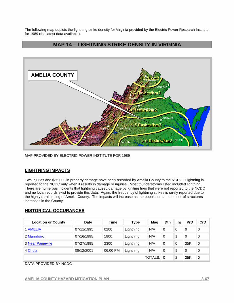
AMELIA COUNTY HAZARD MITIGATION PLAN 3-67
The following map depicts the lightning strike density for Virginia provided by the Electric Power Research Institute for 1989 (the latest data available).
MAP 14 – LIGHTNING STRIKE DENSITY IN VIRGINIA
MAP PROVIDED BY ELECTRIC POWER INSTITUTE FOR 1989 LIGHTNING IMPACTS Two injuries and $35,000 in property damage have been recorded by Amelia County to the NCDC. Lightning is reported to the NCDC only when it results in damage or injuries. Most thunderstorms listed included lightning. There are numerous incidents that lightning caused damage by igniting fires that were not reported to the NCDC and no local records exist to provide this data. Again, the frequency of lightning strikes is rarely reported due to the highly rural setting of Amelia County. The impacts will increase as the population and number of structures increases in the County. HISTORICAL OCCURANCES
Location or County Date Time Type Mag Dth Inj PrD CrD
1 AMELIA 07/11/1995 0200 Lightning N/A 0 0 0 0
2 Mannboro 07/16/1995 1800 Lightning N/A 0 1 0 0
3 Near Paineville 07/27/1995 2300 Lightning N/A 0 0 35K 0
4 Chula 08/12/2001 06:00 PM Lightning N/A 0 1 0 0
TOTALS: 0 2 35K 0
DATA PROVIDED BY NCDC
AMELIA COUNTY

AMELIA COUNTY HAZARD MITIGATION PLAN 3-68
Lightning Event Record Details DATE INJURIES DAMAGE AMOUNT
07/11/1995 0 Power lines struck by lightning. Tool/yard shed set ablaze. Two story garage completely destroyed by lightning ignited fire. Three dirt roads
washed out by heavy rain.
ESTIMATE NOT
PROVIDED
07/16/1995 1 Man was injured when struck by lightning near his home. Several electrical transformers in the area were blown out by the storm. $0
07/27/1995 0
A lightning induced fire heavily damaged a home.
$35,000
08/12/2001 1 A man had a storm door open and lightning hit the rail and jumped to the door he had been holding. He was knocked out briefly and had a
burn mark on his hand.
$0
DATA PROVIDED BY THE NCDC 3-3.6 HAIL STORMS DESCRIPTION Hail is precipitation that is formed when updrafts in thunderstorms carry raindrops upward into extremely cold areas of the atmosphere. Hail can damage aircraft, homes and cars, and can be deadly to livestock and people. One of the people killed during the March 28, 2000 tornado in Fort Worth was killed when struck by grapefruit-size hail. While Florida has the most thunderstorms, New Mexico, Colorado, and Wyoming usually have the most hail storms. Why? The freezing level in the Florida thunderstorms is so high the hail often melts before reaching the ground. Hailstones grow by collision with supercooled water drops. (Supercooled drops are liquid drops surrounded by air that is below freezing which is a common occurrence in thunderstorms.) There are two methods by which the hailstone grows, wet growth and dry growth, and which produce the "layered look" of hail. In wet growth, the hailstone nucleus (a tiny piece of ice) is in a region where the air temperature is below freezing, but not super cold. Upon colliding with a supercooled drop the water does not immediately freeze around the nucleus. Instead liquid water spreads across tumbling hailstones and slowly freezes. Since the process is slow, air bubbles can escape resulting in a layer of clear ice. With dry growth, the air temperature is well below freezing and the water droplet immediately freezes as it collides with the nucleus. The air bubbles are "frozen" in place, leaving cloudy ice. Multi-cell thunderstorms produce many hail storms but usually not the larges hailstones. The reason is that the mature stage in the life cycle of the multi-cell is relatively short which decreases the time for growth. However, the sustained updraft in supercell thunderstorms support large hail formation by repeatedly lifting the hailstones into the very cold air at the top of the thunderstorm cloud. In all cases, the hail falls when the thunderstorm's updraft can no longer support the weight of the ice. The stronger the updraft the larger the hailstone can grow. (SOURCE: NATIONAL WEATHER SERVICE) HAIL STORM IMPACTS Hail storms have rarely been reported but do occasionally occur. Reported storms have included hail up to 1.75 inches in diameter resulting in $12,000 in property damage with no loss of life or injuries as reported by the NCDC. The amount of damage to crops is not reported since this data is not obtained or reported by Amelia County and most are insured.

AMELIA COUNTY HAZARD MITIGATION PLAN 3-69
HISTORICAL OCCURANCES
Location or County Date Time Type Mag Dth Inj PrD CrD
1 AMELIA 07/24/1978 1530 Hail 1.50 in. 0 0 0 0
2 AMELIA 04/02/1990 1524 Hail 0.75 in. 0 0 0 0
3 Amelia 06/30/1994 1529 Hail 0.75 in. 0 0 0 0
4 Amelia 05/08/1998 12:20 PM Hail 0.75 in. 0 0 0 0
5 Chula 09/28/1998 05:31 PM Hail 0.88 in. 0 0 0 0
6 Chula 04/23/1999 04:29 PM Hail 1.00 in. 0 0 0 0
7 Amelia 07/07/1999 03:20 PM Hail 0.75 in. 0 0 0 0
8 Amelia 05/19/2000 05:55 PM Hail 1.25 in. 0 0 2K 0
9 Amelia 05/20/2000 02:45 PM Tstm Wind/hail 0 kts. 0 0 10K 0
10 Morven 06/06/2002 02:30 PM Hail 1.75 in. 0 0 0 0
11 Earls 08/02/2002 01:30 PM Hail 0.88 in. 0 0 0 0
12 Amelia 05/02/2003 07:00 PM Hail 0.75 in. 0 0 0 0
13 Amelia 05/09/2003 02:40 PM Hail 1.00 in. 0 0 0 0
14 Amelia 05/31/2003 01:45 PM Hail 0.88 in. 0 0 0 0
15 Chula 07/07/2004 11:40 AM Hail 0.75 in. 0 0 0 0
16 Morven 04/23/2005 01:40 PM Hail 0.75 in. 0 0 0 0
TOTALS: 0 0 12K 0
DATA PROVIDED BY THE NCDC
Lightning Event 8 Record Details Creating Property Damage Event: Hail
Begin Date: 19 May 2000, 05:55:00 PM EST Begin Location: Amelia
Begin LAT/LON: 37°20'N / 77°59'W End Date: 19 May 2000, 05:55:00 PM EST
End Location: Amelia End LAT/LON: 37°20'N / 77°59'W
Magnitude: 1.25 inches Fatalities: 0
Injuries: 0 Property Damage: $ 2.0K
Crop Damage: $ 0.0
DESCRITION: NONE REPORTED

AMELIA COUNTY HAZARD MITIGATION PLAN 3-70
Lightning Event 9 Record Details Creating Property Damage Event: Tstm Wind/hail
Begin Date: 20 May 2000, 02:45:00 PM EST Begin Location: Amelia
End Date: 20 May 2000, 02:52:00 PM EST End Location: 5 Miles West North West of Earls
Magnitude: 0 Fatalities: 0
Injuries: 0 Property Damage: $ 10.0K
Crop Damage: $ 0.0
DESCRIPTION: 0.88 to 1.75 inch hail reported across southern Amelia county. Several extremely large trees were also downed by thunderstorm winds. One tree was reportedly over 200 years old.
DATA PROVIDED BY THE NCDC 3-3.7 SNOW AND ICE STORMS DESCRIPTION Winter storms are caused by: COLD AIR: below freezing temperatures in the clouds and near the ground are necessary to make snow and/or ice. MOISTURE: to form clouds and precipitation. Air blowing across a body of water, such as a large lake or the ocean, is an excellent source of moisture. LIFT: something to raise the moist air to form the clouds and cause precipitation. An example of lift is warm air colliding with cold air and being forced to rise over the cold dome. The boundary between the warm and cold air masses is called a front. Another example of lift is air flowing up a mountain side. Sometimes winter storms are accompanied by strong winds creating blizzard conditions with blinding wind-driven snow, severe drifting, and dangerous wind chill. Strong winds with these intense storms and cold fronts can knock down trees, utility poles, and power lines. Storms near the coast can cause coastal flooding and beach erosion as well as sink ships at sea. In the West and Alaska, winds descending off the mountains can gust to 100 mph or more damaging roofs and other structures. Heavy accumulations of ice can bring down trees, electrical wires, telephone poles and lines, and communication towers. Communications and power can be disrupted for days while utility companies work to repair the extensive damage. Even small accumulations of ice may cause extreme hazards to motorists and pedestrians. Heavy snow can immobilize a region and paralyze a city, stranding commuters, stopping the flow of supplies, and disrupting emergency and medical services. Accumulations of snow can collapse buildings and knock down trees and power lines. In rural areas, homes and farms may be isolated for days, and unprotected livestock may be lost. In the mountains, heavy snow can lead to avalanches. The cost of snow removal, repairing damages, and loss of business can have large economic impacts on cities and towns. Sleet: Rain drops that freeze into ice pellets before reaching the ground. Sleet usually bounces when hitting a surface and does not stick to objects. However, it can accumulate like snow and cause a hazard to motorists. Freezing Rain: Freezing rain is rain that falls onto a surface with a temperature below freezing. This causes it to freeze to surfaces, such as trees, cars, and roads, forming a coating or glaze of ice. Even small accumulations of ice can cause a significant hazard.

AMELIA COUNTY HAZARD MITIGATION PLAN 3-71
From the Mid-Atlantic Coast to New England...The classic storm is called a Nor'easter. A low pressure area off the Carolina coast strengthens and moves north. Wind-driven waves batter the coast from Virginia to Maine, causing flooding and severe beach erosion. The storm taps the Atlantic's moisture-supply and dumps heavy snow over a densely populated region. The snow and wind may combine into blizzard conditions and form deep drifts paralyzing the region. Ice storms are also a problem. Mountains, such as the Appalachians, act as a barrier to cold air trapping it in the valleys and adjacent low elevations. Warm air and moisture moves over the cold, trapped air. Rain falls from the warm layer onto a cold surface below becoming ice. (SOURCE: NATIONAL WEATHER SERVICE)
MAP 15 - WINTER STORM SEVERITY IN VIRGINIA
WINTER STORM RELATIVE SEVERITY BASED ON ANNUAL SNOWFALL STATISTICS MAP OBTAINED FROM THE GENERAL VIRGINIA MITIGATION PLAN HIRA WINTER STORM IMPACTS (37) Thirty-seven snow and ice storms have been reported to the NCDC that affected Amelia County. There were no deaths or injuries reported as a result of these storms. Property and crop damage reports reflect a regional estimate due to all areas impacted by the storms and not limited to Amelia County. The Planning Committee has reported that there is no know property or crop damage figures available. Total property damage resulting from three of these storms totaled $20,300,000 for the region and damage to crops was reported at $15,000. Damage in Amelia County is normally created when freezing rain accumulates on trees and power lines. The reported storms resulted in damage with ice accumulations ranged from .25 inches to 1 inch creating long-term power outages and fallen trees onto roadways. Both, snow and ice accumulations create hazardous driving conditions resulting in multiple motor vehicle accidents and with the rural setting of Amelia, some areas of the County may become inaccessible due to road conditions. Some residential structures may require long response times for Emergency Services because of the road infrastructure and driving conditions.
AMELIA COUNTY

AMELIA COUNTY HAZARD MITIGATION PLAN 3-72
HISTORICAL OCCURANCES
Location or County Date Time Type Mag Dth Inj PrD CrD
1 AMELIA 12/28/1993 0900 Winter Weather N/A 0 0 0 0
2 VAZ068 01/30/1995 1430 Heavy Snow N/A 0 0 0 0
3 VAZ048>049 - 061>062 - 068>069 01/06/1996 12:00 PM Winter Storm N/A 0 0 100K 15K
4 VAZ048>049 - 060>064 - 067>068 - 070>076
01/11/1996 11:00 PM Heavy Snow N/A 0 0 0 0
5 VAZ060 - 067>069 - 071>072 - 076 - 078 - 083
02/02/1996 02:00 AM Winter Storm N/A 0 0 0 0
6 VAZ048>049 - 060>064 - 067>076 02/16/1996 03:00 AM Winter Storm N/A 0 0 0 0
7 VAZ048>049 - 060>064 - 066>078 - 085
03/01/1996 09:00 PM Winter Storm N/A 0 0 0 0
8 VAZ048>049 - 060>064 - 066>078 - 080>086 - 088>090 - 092>094
03/07/1996 11:00 PM Winter Storm N/A 0 0 0 0
9 VAZ048>049 - 060>094 - 096 - 099>100
12/23/1998 02:00 PM Ice Storm N/A 0 0 20.0M 0
10 VAZ048>049 - 060>062 - 065 - 067>070 - 079>080 - 087>088
01/19/2000 11:00 PM Winter Storm N/A 0 0 0 0
11 VAZ048>049 - 060>062 - 068 01/25/2000 01:00 AM Winter Storm N/A 0 0 0 0
12 VAZ062 - 067>069 01/30/2000 05:00 AM Ice Storm N/A 0 0 200K 0
13 VAZ060>061 - 065>071 - 078>094 - 099
02/22/2001 10:00 AM Winter Storm N/A 0 0 0 0
14 VAZ061>064 - 068>078 - 082>086 - 090 - 099>100
01/02/2002 11:30 PM Winter Storm N/A 0 0 0 0
15 VAZ048>049 - 060>064 - 066>069 - 071
01/19/2002 09:00 AM Winter Storm N/A 0 0 0 0
16 VAZ048>049 - 060>064 - 067>069 - 072>075
12/04/2002 10:00 PM Winter Storm N/A 0 0 0 0
17 VAZ048>049 - 060>100 01/06/2003 06:00 PM Winter Weather/mix
N/A 0 0 0 0
18 VAZ064 - 068 - 070>078 - 080>086 - 088>094 - 099>100
01/16/2003 09:00 PM Winter Storm N/A 0 0 0 0
19 VAZ048>049 - 060>064 - 067>069
01/30/2003 12:00 PM Winter Storm N/A 0 0 0 0
20 VAZ066>068 - 070 - 076>078 - 080
02/06/2003 07:00 PM Winter Storm N/A 0 0 0 0
21 VAZ048>049 - 060>064 - 068>071 - 074>076
02/10/2003 07:00 AM Winter Weather/mix
N/A 0 0 0 0
22 VAZ048>049 - 060>064 - 067>078 - 099
02/15/2003 04:00 PM Winter Storm N/A 0 0 0 0
23 VAZ048>049 - 060>077 - 080 - 02/26/2003 12:00 PM Winter Storm N/A 0 0 0 0
AMELIA COUNTY HAZARD MITIGATION PLAN 3-73
099
24 VAZ048>049 - 060>062 - 065>070 - 079>081 - 087>089 - 092>098
01/09/2004 12:00 AM Winter Storm N/A 0 0 0 0
25 VAZ048>049 - 060>064 - 067>069 - 071 - 074
01/25/2004 02:00 PM Winter Storm N/A 0 0 0 0
26 VAZ060 - 065>068 - 070 - 079>082 - 087>098
02/15/2004 06:00 PM Winter Storm N/A 0 0 0 0
27 VAZ048>049 - 060>100 12/19/2004 09:00 PM Winter Weather/mix
N/A 0 0 0 0
28 VAZ048>049 - 060>100 01/19/2005 12:00 PM Winter Weather/mix
N/A 0 0 0 0
29 VAZ048>049 - 060>098 01/20/2005 06:00 PM Winter Weather/mix
N/A 0 0 0 0
30 VAZ048>049 - 060 - 067>068 - 079 - 082>083 - 085 - 099
01/22/2005 11:00 AM Winter Weather/mix
N/A 0 0 0 0
31 VAZ048>049 - 060>064 - 067>071
01/29/2005 09:00 PM Winter Storm N/A 0 0 0 0
32 VAZ048>049 - 060>073 - 079>098
02/03/2005 01:30 PM Winter Weather/mix
N/A 0 0 0 0
33 VAZ061 - 068>071 - 078 - 083 - 099
02/24/2005 07:00 AM Winter Weather/mix
N/A 0 0 0 0
34 VAZ048>049 - 060>062 - 068>069
02/28/2005 04:00 AM Winter Storm N/A 0 0 0 0
35 VAZ049 - 061>064 - 068>069 - 071>078
12/05/2005 07:00 AM Winter Storm N/A 0 0 0 0
36 VAZ048 - 060>064 - 068>071 - 074>075
12/09/2005 04:00 AM Winter Weather N/A 0 0 0 0
37 VAZ048 - 060>064 - 066>071 - 074>075
12/15/2005 08:00 AM Winter Weather N/A 0 0 0 0
TOTALS: 0 0 20.300M 15K
DATA PROVIDED BY THE NCDC

AMELIA COUNTY HAZARD MITIGATION PLAN 3-74
3-3.8 DROUGHT DESCRIPTION A drought is defined as "a period of abnormally dry weather sufficiently prolonged for the lack of water to cause serious hydrologic imbalance in the affected area." Glossary of Meteorology (1959). In easier to understand terms, a drought is a period of unusually persistent dry weather that persists long enough to cause serious problems such as crop damage and/or water supply shortages. The severity of the drought depends upon the degree of moisture deficiency, the duration, and the size of the affected area. There are actually four different ways that drought can be defined. Meteorological - a measure of departure of precipitation from normal. Due to climatic differences, what might be considered a drought in one location of the country may not be a drought in another location. Agricultural - refers to a situation where the amount of moisture in the soil no longer meets the needs of a particular crop. Hydrological - occurs when surface and subsurface water supplies are below normal. Socioeconomic - refers to the situation that occurs when physical water shortages begin to affect people. Lack of rainfall for an extended period of time can bring farmers and metropolitan areas to their knees. It does not take very long; in some locations of the country, a few rain-free weeks can spread panic and affect crops. Before long, we are told to stop washing our cars, cease watering the grass, and take other water conservation steps. In this situation, sunny weather is not always the best weather. Most locations have sufficient water reservoirs to make it through one dry winter. The real problem becomes back to back dry winter seasons similar to what is occurring during the 1998-2000 period of time. With two significantly below-normal precipitation winter seasons, reservoirs are becoming low and the fire danger rises as the forests dry out. However, summer rains can alleviate the situation, as the monsoon season typically develops by July. The worst drought in 50 years affected at least 35 states during the long hot summer of 1988. In some areas the lack of rainfall dated back to 1984. In 1988, rainfall totals over the Midwest, Northern Plains, and the Rockies were 50-85% below normal. Crops and livestock died and some areas became desert. Forest fires began over the Northwest and by autumn, 4,100,000 acres had been burned. A government policy called "Let Burn" was in effect for Yellowstone National Park. The result? Half of the park--2,100,000 acres were charred when a huge forest fire developed. (SOURCE: NATIONAL WEATHER SERVICE) DROUGHT IMPACTS Amelia County has been included in (3) droughts that have affected multiple jurisdictions in the Commonwealth of Virginia that resulted in $38,000,000 in crop damage across the region. The primary impact in Amelia County is agricultural losses that are normally covered by private insurance and therefore, damage data was not available to the Planning Committee. More than 60% of the land mass of the County is farmland of over 99 acres each. There is no data available differentiating between active crop producing acreage and other uses. The potential for crop loss due to drought can not be predicted. The secondary impact of prolonged drought is the affect on forest land and the increase in potential for forest and wildland fires.

AMELIA COUNTY HAZARD MITIGATION PLAN 3-75
HISTORICAL OCCURANCE
Location or County Date Time Type Mag Dth Inj PrD CrD
1 VAZ060>061 - 063 - 067>069 - 072>074 - 078>083 - 090 - 093 - 096 - 099>100
09/01/1997 12:00 AM Drought N/A 0 0 0 63.8M
2 VAZ048>049 - 060>064 - 067>069 - 071>073 - 075>080 - 085
10/01/1998 12:00 AM Drought N/A 0 0 0 38.8M
3 VAZ048>049 - 060>064 - 067>069 - 071>073 - 075>080 - 085
11/01/1998 12:00 AM Drought N/A 0 0 0 20.0M
TOTALS: 0 0 0 122.570M
3-3.9 EARTHQUAKE DESCRIPTION One of the most frightening and destructive phenomena of nature is a severe earthquake and its terrible aftereffects. An earthquake is a sudden movement of the Earth, caused by the abrupt release of strain that has accumulated over a long time. For hundreds of millions of years, the forces of plate tectonics have shaped the Earth as the huge plates that form the Earth's surface slowly move over, under, and past each other. Sometimes the movement is gradual. At other times, the plates are locked together, unable to release the accumulating energy. When the accumulated energy grows strong enough, the plates break free. If the earthquake occurs in a populated area, it may cause many deaths and injuries and extensive property damage. Today we are challenging the assumption that earthquakes must present an uncontrollable and unpredictable hazard to life and property. Scientists have begun to estimate the locations and likelihoods of future damaging earthquakes. Sites of greatest hazard are being identified, and definite progress is being made in designing structures that will withstand the effects of earthquakes. The Earth is formed of several layers that have very different physical and chemical properties. The outer layer, which averages about 70 kilometers in thickness, consists of about a dozen large, irregularly shaped plates that slide over, under and past each other on top of the partly molten inner layer. Most earthquakes occur at the boundaries where the plates meet. In fact, the locations of earthquakes and the kinds of ruptures they produce help scientists define the plate boundaries. There are three types of plate boundaries: spreading zones, transform faults, and subduction zones. At spreading zones, molten rock rises, pushing two plates apart and adding new material at their edges. Most spreading zones are found in oceans; for example, the North American and Eurasian plates are spreading apart along the mid-Atlantic ridge. Spreading zones usually have earthquakes at shallow depths (within 30 kilometers of the surface). Transform faults are found where plates slide past one another. An example of a transform-fault plate boundary is the San Andreas Fault, along the coast of California and northwestern Mexico. Earthquakes at transform faults tend to occur at shallow depths and form fairly straight linear patterns. Earthquakes are measured by using the Richter Scale and range from 0 to 8 or greater than 8 with 8 being the most sever. The following table describes the meaning of each rating and the amount of damage that should be expected.

AMELIA COUNTY HAZARD MITIGATION PLAN 3-76
THE RICHTER SCALE
RICHTER SCALE EARTHQUAKE EFFECTS Less than 3.5 Generally not felt, but recorded. 3.5 – 5.4 Often felt, but rarely causes damage.
Under 6.0
At most, slight damage to well designed buildings. Can cause major damage to poorly constructed building over small regions.
6.1 – 6.9 Can be destructive in areas up to about 100 kilometers across where people live.
7.0 – 7.9 Major earthquake. Can cause serious damage over large areas.
8.0 or greater Great earthquake. Can cause serious damage in areas several hundred kilometers across.
SOURCE: U.S. GEOLOGICAL SURVEY MAP 16 - EARTHQUAKE PROBABILITIES IN VIRGINIA
STATISTICAL DATA PROVIDED BY THE USGS MAP OBTAINED FROM THE GENERAL VIRGINIA MITIGATION PLAN HIRA
AMELIA COUNTY

AMELIA COUNTY HAZARD MITIGATION PLAN 3-77
EARTHQUAKE IMPACTS There are no reported earthquakes affecting Amelia County by either creating property damage or causing loss of life or injury. The expectation of occurrence is low and the magnitude would not be expected to be severe. The impact of more sever earthquakes would be to structures and critical infrastructure that could result in serious injuries and deaths. HISTORICAL OCCURANCES The most recent occurrence of an earthquake in the region was located 15 miles Southeast of Columbia, Virginia on December 9, 2003 at 15:59 hours and had a magnitude of 4.5. This was felt in Amelia County even though there was no damage reported. The epicenter in Columbia is located approximately 30 miles Northwest of Amelia Courthouse. MAP 17 - USGS MAP OF DECEMBER 9, 2003 EARTHQUAKE NEAR COLUMBIA, VIRGINIA
SOURCE: USGS, A LARGER VIEW IS AVAILABLE IN APPENDIX A

AMELIA COUNTY HAZARD MITIGATION PLAN 3-78
3-3.10 WILDLAND AND FOREST FIRES MAP 18 - FIRE RANK IN VIRGINIA
FIRE RANK IN VIRGINIA ACQUIRED FROM THE GENERAL VIRGINIA MITIGATION PLAN HIRA MAP AVAILABLE IN LARGER VIEW IN APPENDIX A Amelia County is ranked by the Virginia Department of Forestry as a Medium to High Risk for wildland and forest fires. The following information is provided by the Department of Forestry. DESCRIPTION Wildfire is a unique hazard in that it can be significantly altered based on efforts to control its course during the event. Spring (March and April) and fall (October and November) are the two seasons for wildfires. The Virginia Department of Forestry (VDOF) indicates that there are three principle factors that can lead to the formation of wildfire hazards: topography, fuel, and weather. The environmental conditions that exist during these seasons exacerbate the hazard. When relative humidity is low and high winds are coupled with a dry forest floor (brush, grasses, leaf litter), wildfires may easily ignite. Years of drought can lead to environmental conditions that promote wildfires. In Virginia, accidental or intentional setting of fires by Humans is the largest contributor to wildfires. Residential areas that expand into wildland areas also increase the risk of wildfire threats.
AMELIA COUNTY

AMELIA COUNTY HAZARD MITIGATION PLAN 3-79
MAP 19 - VA. DEPT. OF FORESTRY POPULATION DENSITY MAP OF AMELIA COUNTY
MAP PROVIDED BY THE
VIRGINIA DEPARTMENT OF FORESTRY
RED INDICATES THE HIGH
POPULATION DENSITY
GREEN INDICATES THE MEDIUM POPULATION
DENSITY
YELLOW INDICATES THE LOW POPULATION DENSITY
Virginia's population continues to increase. Population expansion, viewed positively as a sign of economic growth, creates challenges to the environment. First, natural resources and green infrastructure can be used improperly or threatened. Second, roads, utilities, and other "gray" infrastructure, overloaded by the pace of expansion, strain to provide adequate levels of service. Lastly, the conversion of forestland to non-forest use by home or commercial building can result in the loss of "quality of life. The traditional development pattern of Amelia County has generally been one of single family dwellings on rural lots, sparsely scattered among forests and farms, as well as small clusters of structures in compact settlements. Small country stores and churches serve as community focal points, with the courthouse area the central focus for the County. New residential development has tended to occur as either incremental, single lot development or small, rural subdivisions in a somewhat scattered, “strip” pattern, based upon the opportunities provided by road frontage, permeable soils and ownership intentions to develop. During recent years, the relatively low cost of rural residential lots, combined with the access to jobs in the Richmond and Petersburg areas have increased the demand for rural housing development in Amelia. With improved transportation and communication technologies, households and employment centers tend to become more dispersed, as home buyers seek the lowest land prices and more comfortable rural lifestyles. The local forester for Amelia County has identified the method of residential growth in the County creates access issues when attempting to protect structures from forest fires. As forest fires develop and move toward dwellings, firefighting resources have to relocate and access each individual structure by rural roads and long driveways. The larger commercial and industrial establishments have tended to concentrate along the Route 360 corridor, north of Route 360 and along Route 153. Commercial uses have also concentrated in the Courthouse area, along with most of the public buildings. The Courthouse area has declined somewhat, however, as a commercial center for the County, likely due in part to the construction of the nearby shopping center on Route 360 and by the increased accessibility of residents to commercial centers in neighboring jurisdictions. (Data provided by the Virginia Department of Forestry)

AMELIA COUNTY HAZARD MITIGATION PLAN 3-80
WILDLAND FIRE IMPACTS MAP 20 - POPULATION DENSITY IN YEAR 1990 FOR AMELIA COUNTY
This map is provided by the Virginia Department of Forestry and shows a medium population density primarily located on the Route 360 corridor and the Amelia Courthouse area of the County. A larger view of this map is available in Appendix A.
MAP 21 - POPULATION DENSITY IN YEAR 2000 FOR AMELIA COUNTY This map is provided by the Virginia Department of Forestry and shows a medium population density that has grown in the year 2000 beyond the Route 360 corridor and the Amelia Courthouse area of the County. These areas are rural areas that are heavily wooded and difficult to access. A larger view of this map is available in Appendix A.

AMELIA COUNTY HAZARD MITIGATION PLAN 3-81
The wildland-urban interface is the contact zone between undeveloped forested areas and urban areas. These two land uses, wilderness and urban, are fixed; the rural land in between is in a state of flux. Increasing rural populations, urban sprawl, recreational use of wildland, and increasing forest fuel loads all pose a threat to the interface. This transitional environment is most susceptible to fire. As people and wildlands come into contact, conflict arises from the threat of wildfire or from an inadequate emergency services to protect rural populations. Many "new" rural homeowners, accustomed to fire protection resources found in cities, are unaware of the potential wildfire risk to their life and property. The wildland-urban interface has the potential to become a major fire problem that will continue to escalate in Virginia. Fire protection personnel in Amelia County have experienced the same decline in available volunteer personnel that other rural areas have experienced. This situation is at a critical point during daytime hours when most personnel are at their jobs and unavailable to respond to fires. This shortage in resources is of particular importance when evaluating the ability of a locality to control wildland fires and preventing the loss of structures. Wildland fires require large numbers of personnel as well as multiple units to provide control tactics in all directions the fire spreads. (Data provided by the Virginia Department of Forestry)
MAP 22 - WILDLAND INTERFACE MAP OF AMELIA COUNTY
MAP PROVIDED BY THE VIRGINIA DEPARTMENT OF FORESTRY

AMELIA COUNTY HAZARD MITIGATION PLAN 3-82
MAP 23 - VIRGINIA DEPARTMENT OF FORESTRY 2003 RISK ASSESSMENT
MAP PROVIDED BY THE VIRGINIA DEPARTMENT OF FORESTRY. The Virginia Department of Forestry conducted a Risk Assessment of Amelia County in 2003 that indicates the high risk areas in the color red in the map above. The green areas indicate the moderate risk areas. In 2002 and 2003, Virginia Department of Forestry examined which factors influence the occurrence and advancement of wildfires and how these factors could be represented in a GIS model. VDOF determined that historical fire incidents, land cover (fuels surrogate), topographic characteristics, population density, and distance to roads were critical variables in a wildfire risk analysis. The resulting high, medium, and low risk category reflect the results of this analysis.
AMELIA COUNTY
LEGEND
HIGH RISK
MODERATE RISK
LOW RISK

AMELIA COUNTY HAZARD MITIGATION PLAN 3-83
HISTORICAL OCCURANCES MAP 24 - HISTORICAL FIRE DATA PROVIDED BY VIRGINIA DEPARTMENT OF FORESTRY SINCE 1985 MAP PROVIDED BY THE VIRGINIA DEPARTMENT OF FORESTRY The Virginia Department of Forestry has verified that the data points in the above map represent reported forest fires from 1985 to 2003 that were reported by the local forester. This map does not include all fires that occurred in the time period and the areas noted on the map by red notations represent the general area the fires occurred. There are no records available that provide a more accurate or up-to-date record of forest related fires for the County. (Information Provided by the Virginia Department of Forestry) The impact of wildland fires on the County is primarily the hazard to residential structures. The County has implemented zoning and building requirements that limit the distance a dwelling can be constructed from a paved road by restricting the length of driveways. They have also implemented recommendations for creating a green space or clear buffer between the forest land and dwellings. As in all rural communities, all residential structures located in forest land are threatened by wildland fires. Future growth and development is planned for clustering homes in the Amelia Courthouse Village which is not threatened due to the lack for forest land in the village.

AMELIA COUNTY HAZARD MITIGATION PLAN 3-84
3-4 Vulnerability and Risk Assessment 3-4.1 Critical Facilities and Areas of Concern It is important to determine which critical facilities are the most vulnerable and to estimate their potential loss. The first step is to identify the facilities most likely to be damaged in a hazard event. To do this, the location of critical facilities illustrated on Map 29A, 29B, and 29C in Appendix A are compared to the location of various topographical elements, floodplains, roads, and water bodies. Vulnerable facilities were identified by comparing their location to possible hazard events. For example, all of the facilities within the 100-year and 500-year floodplain were identified and used in conducting the potential loss analysis. Similarly, facilities near slopes, vulnerable to severe winter weather, hazardous materials incidents and high traffic congestion, etc. were identified and included in the analysis. Map 30 displays the facilities that were identified during this analysis.
TABLE #9 – CRITICAL FACILITIES IN AMELIA COUNTY
Facility Number
Critical Facility Name Address Type
Facility
Stor
ies
Emergency Power
Building Value*
IN 100 YEAR
FLOOD PLAIN
IN 500 YEAR
FLOOD PLAIN
1 Amelia County Administration Building
16360 Dunn Street Brick Office Building 2 Yes $601,800 NO NO
Amelia County Courthouse 16441 Court Street Brick Office
Building 2 Yes $2,272,700 NO NO 2 (3)
Amelia County Sheriff Office 16441 Court Street Brick Office
Building 1 Yes Included in above figure NO NO
4 Public Safety Communications Tower Rt. 627 – Cheatham Road
Public Safety Communications Tower
Not owned by Amelia NO NO
5 Amelia Sewage Treatment Plant
10105 Pridesville Road Amelia, VA
Brick Office/Lab Building 1 Yes
Not accessed as
of yet NO NO
6 Water Tank Rt. 360 at Business Rt. 360 Water Tank 167’ Yes Not Avail. NO NO
7 Fire Station #1 8950 Otterburn Road Engineered Metal Building 2 Yes $406,700 NO NO
8 Fire Station #2 8641 Namozine Road Engineered Metal Building 1 Yes $137,100 NO NO
9 Fire Station # 3 21575 Jetersville Road Engineered Metal Building 1 Yes $157,900 NO NO
10 Fire Station # 4 12201 Genito Road Masonry Building 1 Yes $90,200 NO NO

AMELIA COUNTY HAZARD MITIGATION PLAN 3-85
TABLE #9 – CRITICAL FACILITIES IN AMELIA COUNTY
Facility Number
Critical Facility Name Address Type
Facility
Stor
ies
Emergency Power
Building Value*
IN 100 YEAR
FLOOD PLAIN
IN 500 YEAR
FLOOD PLAIN
11 Fire Station # 5 12151 Fowlkes Bridge Road Engineered Metal Building 1 Yes $111,600 NO NO
12 Amelia Rescue Squad 8930 Otterburn Road Brick Bldg. 1 $30,000 NO NO
13 Amelia Nursing Center 8830 Virginia Street Wood Frame Building 1 Yes $3,438,600 NO NO
14 Amelia High School 8500 Otterburn Road Masonry Building 1 Yes $8,048,200. NO NO
15 Amelia Middle School 8740 Otterburn Road Masonry Building 1 Yes $5,203,700 NO NO
16 Amelia Elementary School 8533 N. Five Forks Road Masonry Building 1 Yes $6,990,800 NO NO
17 Amelia Academy 8741 N. Five Forks Road Masonry Building 1 $1,593,600 NO NO
18 Love Covenant School 16410 Dunn Street Masonry Building
1 & Basement
$601,800 NO NO
19 Ingleside (Cedar Grove) 10920 Rodophil Road Dwelling 2 $385,400 NO NO
20 Grubb Hill Church Grubb Hill Church Road, 3.8 miles north of Rt. 360
Brick Historic Church 1 Unknown NO NO
21 Father John Bannister Tabb’s Monument
Rt. 609, 2 miles North of St. John’s Church
Marble Monument Unknown NO NO
22 Egglesetton Plantation 16520 Egglestetton Road Dwelling 2 $355,800 NO NO
23 The Wigwam Home of Governor William B. Giles
17110 Giles Road Dwelling 2 $499,300 NO NO
24 Haw Branch North of Amelia off Rt. 667 Dwelling 2 $364,500 NO NO 25 Dykeland 13001 Dykeland Road Dwelling 2 $377,100 NO NO 26 Winterham 11440 Grub Hill Church Road Dwelling 2 $1,007,200 NO NO

AMELIA COUNTY HAZARD MITIGATION PLAN 3-86
TABLE #10 – AREAS OF CONCERN IN AMELIA COUNTY
Facility Number Areas of Concern Address Type
Facility
Stor
ies
Emergency Power
Building Value
In 100 Year Flood Plain
In 500 Year Flood Plain
27 Amelia Medical Center Otterburn Road 1 $666.900 NO NO
28 Gambro Health Care Center Rt. 360 in Village Square Shopping Center 1
Assessed w/Shopping
Center NO NO
29 Hope Chapel Day Care Center Wayside Drive 1 Not Available NO NO
30 Day Care at Amelia Baptist Church 1 Not Available NO NO
31 James L. Hamner Public Library
16351 Dunn Street Amelia, VA Library 1 Yes $581,300 NO NO
32 Virginia Veteran’s Cemetery
10300 Pridesville Road Amelia, VA 23002
Masonry Office Building 1 $444,400 NO NO
33 Saylers Creek Battlefield State Park
Rt. 618, Southwest end of County State Park Not Available NO NO
34 Route of Lee’s Retreat Throughout County Route Not Available NO NO
35 Amelia County Park Rt. 38 at Rt. 614 Recreational Facilities 2 $476,100 NO NO
36 Apartment Complex 8710 Virginia Street Multi Family Dwelling 2 $602,300 NO NO
37 Apartment Complex 16330 Court Street Multi Family Dwelling 2 $602,300 NO NO
38 Mannboro Medical Center 8631 Namozine Road Amelia, VA
Masonry Medical Facility 1 $292,200 NO NO
39 Industrial Park Off 15300 Patrick Henry Highway
Several Facilities $9,369,600 NO NO
40 A,B,C Landfills
A) End of Crowder St. B) End of Epps Ln. C) Maplewood Rd. off Rt. 360
A) Closed Landfill B) Closed Landfill C) Active Private Landfill
Not Available NO NO
41 Railway Parallel Rt. 360 Not Available
* BUILDING VALUES OBTAINED FROM THE AMELIA COUNTY COMMISSIONER OF REVENUE THROUGH THE COUNTY ADMINISTRATOR’S OFFICE

AMELIA COUNTY HAZARD MITIGATION PLAN 4-87
3-4.2 Hazards to Critical Facilities and Areas of Concern After past events have been identified, the next step in the planning process is to determine where the past hazards and future hazards could potentially occur and what structures or areas could be affected. This requires determining which facilities and areas in the community are considered to be exposed to hazards and to what extent damage would occur. Each critical facility and area was mapped and included on a large scale map in Appendix A. Table 8 presents the critical facilities and areas of concern identified by the County of Amelia.
TABLE #11 - HAZARD RATINGS FOR CRITICAL FACILITIES and AREAS OF CONCERN
Name
Floo
d
Hur
rican
es a
nd
Trop
ical
Sto
rms
Torn
ados
Thun
ders
torm
s an
d H
igh
Win
ds
Ligh
tnin
g
Hai
l
Win
ter S
torm
s
Dro
ught
Eart
hqua
ke
Wild
Fire
Amelia County Administration Building L L M M M L L L L L Amelia County Courthouse L L M M M L L L L L Amelia County Sheriff Office L L M M L L L L L L Public Safety Communications Tower L M M M M L L L L L Amelia Sewage Treatment Plant M M M L L L L L L L Water Tank L M M M L L L L L L Fire Station #1 L M M M M L L L L L Fire Station #2 L M M M M L L L L L Fire Station # 3 L M M M M L L L L L Fire Station # 4 L M M M M L L L L L Fire Station # 5 L M M M M L L L L L Amelia Rescue Squad L M M M M L L L L L Amelia Nursing Center L M M M M L L L L L Amelia High School L M M M M L L L L L Amelia Middle School L M M M M L L L L L Amelia Elementary School L M M M M L L L L L Amelia Academy L M M M M L L L L L Love Covenant School L M M M M L L L L L Ingleside (Cedar Grove) L M M M M L L L L L Grubb Hill Church L M M M M L L L L L Father John Bannister Tabb’s Monument L L L L L L L L L L
Egglesetton Plantation L M M M M L L L L L The Wigwam, Home of Governor William B. Giles L M M M M L L L L L
Winterham L M M M M L L L L L
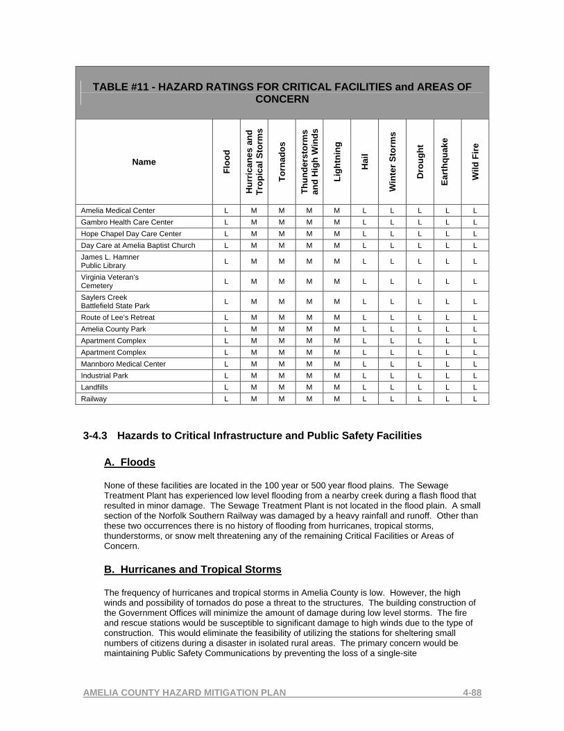
AMELIA COUNTY HAZARD MITIGATION PLAN 4-88
TABLE #11 - HAZARD RATINGS FOR CRITICAL FACILITIES and AREAS OF CONCERN
Name
Floo
d
Hur
rican
es a
nd
Trop
ical
Sto
rms
Torn
ados
Thun
ders
torm
s an
d H
igh
Win
ds
Ligh
tnin
g
Hai
l
Win
ter S
torm
s
Dro
ught
Eart
hqua
ke
Wild
Fire
Amelia Medical Center L M M M M L L L L L Gambro Health Care Center L M M M M L L L L L Hope Chapel Day Care Center L M M M M L L L L L Day Care at Amelia Baptist Church L M M M M L L L L L James L. Hamner Public Library L M M M M L L L L L
Virginia Veteran’s Cemetery L M M M M L L L L L
Saylers Creek Battlefield State Park L M M M M L L L L L
Route of Lee’s Retreat L M M M M L L L L L Amelia County Park L M M M M L L L L L Apartment Complex L M M M M L L L L L Apartment Complex L M M M M L L L L L Mannboro Medical Center L M M M M L L L L L Industrial Park L M M M M L L L L L Landfills L M M M M L L L L L Railway L M M M M L L L L L
3-4.3 Hazards to Critical Infrastructure and Public Safety Facilities A. Floods
None of these facilities are located in the 100 year or 500 year flood plains. The Sewage Treatment Plant has experienced low level flooding from a nearby creek during a flash flood that resulted in minor damage. The Sewage Treatment Plant is not located in the flood plain. A small section of the Norfolk Southern Railway was damaged by a heavy rainfall and runoff. Other than these two occurrences there is no history of flooding from hurricanes, tropical storms, thunderstorms, or snow melt threatening any of the remaining Critical Facilities or Areas of Concern.
B. Hurricanes and Tropical Storms
The frequency of hurricanes and tropical storms in Amelia County is low. However, the high winds and possibility of tornados do pose a threat to the structures. The building construction of the Government Offices will minimize the amount of damage during low level storms. The fire and rescue stations would be susceptible to significant damage to high winds due to the type of construction. This would eliminate the feasibility of utilizing the stations for sheltering small numbers of citizens during a disaster in isolated rural areas. The primary concern would be maintaining Public Safety Communications by preventing the loss of a single-site
AMELIA COUNTY HAZARD MITIGATION PLAN 4-89
communications tower that provides all the communications capabilities for the County. High winds would threaten the tower since it is constructed to support cellular equipment along with the County’s public safety equipment.
C. Tornados, Thunderstorms, Lightning, High Winds, Hail
Tornados pose the potential of causing catastrophic damage to all facilities even though the frequency of powerful tornados in Amelia County is low. The frequency of tornados in relationship to the entire region is moderate and the potential for a tornado or high winds causing damage to any structure exists. High winds can be the result of not only tornados, but during frequent thunderstorms experienced by the County. These storms result in frequent cloud to ground lightning that has the potential for damaging these structures as well as igniting fires. Lightning poses a potential loss to Public Safety Communications at the radio tower even though there is lightning protection in place. The highest potential for hail damage is to crops since Amelia County has a large geographic area dedicated to agriculture. Most of these crops however are covered by crop damage insurance. D. Winter Storms Including Heavy Snow and Ice Storms Heavy snow and ice poses little to no potential for measurable damage to structures in the County. Based on the construction types of most buildings, they will withstand even heavier than expected snowfall. The communications tower again is of concern if a large accumulation of ice increases the weight of the tower and the storm is accompanied by high winds that occur in this region. Some winter storms are produced by a storm caused by a Nor’easter that frequently is accompanied by high winds. E. Drought The biggest threat to the County by significant drought conditions is limited to crops and water supply. The primary water supply for small geographic areas of the County is wells. These wells provide water supply to the Amelia County Courthouse are and are utilized for both domestic use and firefighting. An extreme drought for a long term would have to occur to affect the water table and ultimately affect the water supply. F. Earthquake The effect of a significant earthquake with an epicenter near the Amelia County Courthouse area could be catastrophic to the building supporting the government infrastructure and Public Safety. However, the potential for this magnitude of earthquake is extremely low. G. Wildfire Even though the wild fire potential in Amelia County in general is high, the critical infrastructure for the County is located in the village of Amelia Courthouse that is well protected by natural barriers. The Virginia Department of Forestry, Amelia County Forest Warden has ranked the wildfire threat to all critical facilities and areas of concern as low.
3-4.4 Hazards to High Occupancy and Historical Facilities A. Floods
None of these facilities are located in the 100 year or 500 year flood plains. There is no history of flash flooding from hurricanes, tropical storms, thunderstorms, or snow melt threatening any of these facilities.
B. Hurricanes and Tropical Storms

AMELIA COUNTY HAZARD MITIGATION PLAN 4-90
The frequency of hurricanes and tropical storms in Amelia County is low. However, the high winds and possibility of tornados do pose a threat to the structures. The building construction of some of the historical sites or those that are open spaces will increase the potential amount of damage during significant storms. Many of the historical sites are either structures or open spaces related to the Civil War area and would be susceptible to significant damage to high winds.
C. Tornados, Thunderstorms, Lightning, High Winds, Hail
Tornados pose the potential of causing catastrophic damage to all facilities even though the frequency of powerful tornados in Amelia County is low. The frequency of tornados in relationship to the entire region is moderate and the potential for a tornado or high winds causing damage to any structure exists. High winds can be the result of not only tornados, but during frequent thunderstorms experienced by the County. These storms result in frequent cloud to ground lightning that has the potential for damaging these structures as well as igniting fires. D. Winter Storms Including Heavy Snow and Ice Storms Heavy snow and ice poses little to no potential for measurable damage to structures in the County. Based on the construction types of most buildings, they will withstand even heavier than expected snowfall. Some winter storms are produced by a storm caused by a Nor’easter that frequently is accompanied by high winds. E. Drought The only threat to these facilities is to the water supply to the historical sites still being utilized as single family dwellings. A long term drought that reduces the ground water table will affect the wells being utilized for domestic water within the facility. F. Earthquake The effect of a significant earthquake with an epicenter near the Amelia County Courthouse area could be catastrophic to all structures. However, the potential for this magnitude of earthquake is extremely low. G. WildfIre The wild fire potential in Amelia County in general is high. The Virginia Department of Forestry, Amelia County Forest Warden has ranked the wildfire threat to all high occupancy facilities and historical sites low.
3-4.5 Hazards to Transportation A. Floods
The railway that transverses Amelia County is generally located along a parallel path next to State Route 360. This route does not cross any areas identified in the 100 year or 500 year flood plain. There has been one occurrence that damage was experienced at a crossing where water from a flash flood undermined the track. Roadways are frequently closed due to high water form flash floods however the damage to the roadways, bridges, or culverts is not frequent.
B. Hurricanes and Tropical Storms

AMELIA COUNTY HAZARD MITIGATION PLAN 4-91
The frequency of hurricanes and tropical storms in Amelia County is low. However, the high winds and possibility of tornados do pose a threat to the transportation routes. Other than high water, downed trees and power lines frequently close roads during high wind events.

AMELIA COUNTY HAZARD MITIGATION PLAN 4-92
C. Tornados, Thunderstorms, Lightning, High Winds, Hail
The frequency of tornados in relationship to the entire region is moderate and the potential for a tornado or high winds causing damage to any road or railway exists. High winds can be the result of not only tornados, but during frequent thunderstorms experienced by the County. These storms result in frequent cloud to ground lightning that has the potential for downing trees and power lines that may block roadways. D. Winter Storms Including Heavy Snow and Ice Storms Heavy snow and ice often causes traffic accidents with some resulting in personal injury. The rural roads in Amelia County are often impassable when there is a measurable snowfall that compacts on the roadway or when there is an accumulation of ice. This situation often creates a situation where Public Safety first response agencies have extreme difficulty reaching rural areas of the County due to road conditions. E. Drought There are no threats to transportation routes created by drought. F. Earthquake The effect of a significant earthquake with an epicenter near the Amelia County Courthouse area could be catastrophic to any transportation route. However, the potential for this magnitude of earthquake is extremely low. G. WildFire The wild fire potential in Amelia County in general is high. The only threat to transportation routes due to wild fire would be closing of road and railways die to smoke and fire conditions. Transportation routes may also be closed to allow access for firefighting resources.
3-4.6 Power Outages
Many of the hazards addressed in this plan have the potential for either short-term or long-term power outages. All of the Government buildings, Public Safety facilities, and schools utilized as emergency shelters are equipped with emergency generators. The primary impact of long-term power outages will be on singe and multi-family residential structures. Some are equipment with generators. Those that are not that the occupants require services will be assisted by locating those individuals to buildings with emergency power such as local fire and rescue stations or by opening shelters. The only special needs facility located in the County is the Nursing Home and it is equipped with an emergency generator.

AMELIA COUNTY HAZARD MITIGATION PLAN 4-93
3-4.7 Future Growth
A. Floods
Amelia County has prohibited construction in the flood plain by implementing a zoning ordinance. There are no expected issues in the future that would be created by flooding that do not already exist today.
B. Hurricanes, Tropical Storms, Tornados, Thunderstorms, Lightning, High Winds, Hail, Winter Storms, Ice Storms, and Power Outages
The obvious result of future growth with all hazards in this plan is the increase in structures and population. The current plan expects the population to double in the next eight years. Therefore, there will be more citizens and structures exposure to the weather related hazards. The increase in traffic magnifies need to keep roadways open and electrical power service. As the population and number of residential structures increases, so will the increase on demand for Public Safety Services and their ability to access the population. This expected growth will also increase commercial growth that is affected as stated above. The County will have to modify its’ sheltering and recovery plans to handle the increase in population expected. This is magnified by the change in population type. The current population rarely requires services from the County to provide sheltering or recovery assistance after a major weather event. The influx of people moving into the area from other regions is expected to change this concept and the added population will require assistance when major events occur. C. Wildfire The wild fire potential in Amelia County in general is high. The expected growth in rural areas will increase the number of structures being built in forested areas. The potential for structure fires resulting from forest fires increases. The interface between structures and forests will continue to provide a stress on response resources for protection. Another factor provided by the local Forester in Amelia County is the lack of access for proposed developments. The typical subdivision development process is not normally proposed in the expect growth. Residential development is normally proposed to provide large lots on rural roads that developers will build structures. These lots are normally heavily wooded and the interface issue will continue to exist. The other affect of this type of development also includes and access issue since resources have to travel rural roads and locate in driveways to protect structures. It is obvious that the locating firefighting apparatus at individual homes will stretch the current resource capabilities. Also, the time required to relocate apparatus from one structure to another is critical to protecting structures and will be difficult at best.

AMELIA COUNTY HAZARD MITIGATION PLAN 4-94
3-4.8 VULNERABILITY RISK TO STRUCTURES BY HIGHEST RANKING HAZARDS AND FLOODS A. Potential Structures The Amelia County Commissioner of Revenue Office does not separate records by structure types. The Amelia County Comprehensive Plan first developed in 1991 and updated in 2000 recorded 1,490 permits issued from 1983 to 2000 for single-wide mobile homes. To avoid using calculations based on County property tax revenue that would include farm barns and sheds, the following data was utilized to determine hazard impact potential as provided by The U.S. Census Bureau.
Residential Housing Units – Year 2000 Total housing units 4,609 100.0 100.0%
Occupied housing units 4,240 92.0 91.0% Owner-occupied housing units 3,474 81.9 66.2% Renter-occupied housing units 766 18.1 33.8%
Vacant housing units 369 8.0 9.0% Since many of the following types of businesses may be and are operated from home offices, the following totals do not represent an actual structure and are not reported as structures by the U.S. Census Bureau or the Amelia County Commissioner of Revenue Office. This data only represents the types and numbers of business located in the County and can be utilized to estimate actual numbers of structures. Commercial and Industrial building values are $19,066,000 as recorded in the Amelia County Comprehensive Plan from the year 1989 to year 2000. Commercial and Non-Profit Businesses with Employees reported by the U.S. Census Bureau in
Year 2002 Professional, scientific, & technical services 8Educational services 3Health care & social assistance 18Arts, entertainment, & recreation 2Other services (except public administration) 26TOTAL 57
Sole Proprietorships, Partnerships, and Individual Corporations reported by the U.S. Census
Bureau in Year 2003 Utilities D*
Construction 177Manufacturing D*Wholesale trade D*Retail trade 72Transportation & warehousing 30Information D*Finance & insurance 14Real estate & rental & leasing 57Professional, scientific, & technical services 49Administrative & support & waste management & remediation service 75Educational services D*Health care & social assistance 37Arts, entertainment, & recreation 15Accommodation & food services 13Other services (except public administration) 131TOTAL 670

AMELIA COUNTY HAZARD MITIGATION PLAN 4-95
* D indicates the information was not provided to the U.S. Census Bureau

AMELIA COUNTY HAZARD MITIGATION PLAN 4-96
B. Flood Impact Potential Flooding potential in Amelia County is normally limited to flash floods that cover roadways and historical damage to roadways has been minimal. The only reported damage was as a result of over 15 inches of rain that accompanied Tropical Storm Isabel and damaged one road. Research was conducted on the Virginia Department of Emergency Managements hisory of floods in Virginia to confirm all flood related data provided in this plan. River flooding has occurred on the Appomatox River as a result of major rainfall associated with tropical storms and hurricanes along with snowmelt from significant, repetitive snow storms affecting the region. Data provided by the Virginia Department of Recreation and Conservation has confirmed eight occurances of structural damage due to flooding of the Appomatox River. A County Ordinance prohibits construction in the 100 and 500 year floodplains resulting in very limited impacts from high river levels. There are two residential structures that are located in the floodplain and have been determined to be the only two structures that would be impacted by Appomatox River flooding. Refer to Table 7 in this chapter for the details of previous flood damage the structures provided by the Virginia Department of Recreation and Conservation. Structure #1 listed in Table 7 is a single story, masonary, single family residence that is valued by the Amelia County Commissioner of Revenue Office at $85,500 with a land value of $27,000 for a total of $112,500. Structure #2 listed in Table 7 is a two story, wood frame, single family residence with an eleveated masonary foundation providing a basement above ground. This property is valued by the Amelia County Commissioner of Revenue Office at $67,800 with a land value of $19,600 for a total of $87,400. TOTAL FLOOD IMPACT POTENTIAL TO STRUCTUES IS $199,900 C. Tornado Impact Potential Amelia County’s threat hazard ranking from tornadoes is medium. The path, magnitude, damage path width or length of a tornado strike can not be predicted. It has been confirmed by the Amelia Hazard Mitigation Planning Committee that all Critical Facilities and Areas of Concerns are potential location for damage from tornadoes. Each are listed in Table 9 and Table 10 of this chapter which contain those available property values provided by the Ameila County Commissioner of Revenue Office. All commercial and residential structures in the County are also potential targets for tornadoes. Commercial and Industrial building values are $19,066,000 as recorded in the Amelia County Comprehensive Plan from the year 1989 to year 2000 and are potential targets for this type of event. Commercial and Industrial buildings are constructed of either wood frame, brick and wood frame, block and frame, and steel pre-engineered buildings. All residential structures have the potential for damage from tornadoes and the median value in year 2000 provided by the U.S. Census Bureau is $92,400. The majority of the residential structures in the County are 1 and 2 story, wood frame constructed homes with the remaining construction types listed as brick and frame or block and frame. The Virginia Department of Forestry, Amelia County Forest Warden has provided data that estimates the number of modular, pre-manufactured, double-wide homes at approximately 200 located in 8 subdivisions. The Amelia County Comprehensive Plan first developed in 1991 and updated in 2000 recorded 1,490 permits issued from 1983 to 2000 for single-wide mobile homes. The U.S. Census Report “2000” states there were 4,609 residential structures in Amelia County that had a median value of $92,400. The total residential value based on the multiplier of the median value is $425,871,600.

AMELIA COUNTY HAZARD MITIGATION PLAN 4-97
D. Wildfire Impact Potential Amelia County’s threat hazard ranking from wildfire is medium. The Virginia Department of Forestry, Amelia County Forest Warden has determined that none of the Critical Facilities or Areas of Concern are all located in areas of the County where the threat from wildfire would be very low. The highest threat potential from wildfire is subdivisons built in or very near wooded areas. Most subdivisions have one road providing access by firefighting equipment that could possibly be blocked by the fire. Firefighting resources must be deployed to these structures to provide protection. NUMBER OF SUBDIVISIONS 135SUBDIVISION RANGE OF LOTS WITH RESIDENTIAL STRUCTURES BUILT OR AVAILABLE
1-80
NUMBER OF LOTS IN SUBDIVISIONS WITH RESIDENTIAL STRUCTURES BUILT OR AVAILABLE
1,520
DATA PROVIDED BY THE AMELIA COMMISSIONER OF REVENUE OFFICE NUMBER OF HOMES IMPACTED BY WILDFIRE POTENTIAL 951NUMBER OF HOMES NOT IMPACTED BY WILDFIRE POTENTIAL 569NUMBER OF MODULAR, PRE-MANUFACTURED HOMES IN SUBDIVISIONS 200*NUMBER OF MODULAR. PRE-MANUFACTURED HOMES IMPACTED BY WILDFIRE POTENTIAL
90*
DATA PROVIDED BY THE VIRGINIA DEPARTMENT OF FORESTRY, AMELIA FOREST WARDEN Utilizing the largest subdivison that contains 80 homes, the highest potential for structural losses would be $7,392,000 when utilizing the median residential structure value provided by the U.S. Census Report 2000. Using ¼ of the median residential structure value to estimate home contents value, property contents values could be estimated at $1.848,000. The total potential loss due to wildfire for the largest subdivision totals $9,240,000.
CHAPTER 4 – CAPABILITY ASSESSMENT 4-1 Capability Assessment Process Once the hazards for Amelia County were identified and the risks assessed, the next step in the process was to gather information from the Mitigation Planning Committee that would be considered mitigation strategies already developed by the County and evaluate their effectiveness in minimizing or eliminating risk. This information was gathered during each meeting held with the committee. An additional meeting with County Administrative staff was held to obtain and review the details of each of the plans. This meeting served to provide specific ordinances that directly related to mitigation and determine how effective they have been to reduce losses over time. As individual specific hazards were discussed, County Officials and committee members were asked what existing plans adopted by the County would contain regulations that would mitigate the hazards.

AMELIA COUNTY HAZARD MITIGATION PLAN 4-98
All information included in the Capabilities Assessment was provided by the committee and other County Officials. A detailed review of the following plans was conducted to obtain existing, adopted, and enforced regulations:
1. Comprehensive Plan 2. Land Use Plan 3. Subdivision Ordinance 4. Zoning Ordinance 5. NFIP/FPM Ordinance 6. Building Code 7. Local Emergency Operations Plan
This list of Plans will serve as the references for the remaining sections of this chapter along with the specific inputs from the Hazard Mitigation Committee and Amelia County Administrative Staff. 4-2 Plan Review Matrix Table 12 is a detail plan review matrix that provides the data collected during the review of each plan. The frequency that each plan is updated is noted in the table to indicate the pro-active approach that County Officials have taken to ensure the plans change to meet their needs for the future of the county. County Officials ranked their level of enforcement capabilities in each area of the plans and provided who is responsible for that enforcement.

AMELIA COUNTY HAZARD MITIGATION PLAN 4-1-3
Table 12: Plan Review Matrix
Existing Mitigation Strategy/Process
Plan Adoption and Update Plan
Area of County
Covered Enforcement Authority Enforecment
Effectiveness Improvement or Changes Needed
Comprehensive Plan 2000-2025 Updated Every 5 Years All Board of Supervisors /
County Administrator Highly
Effective Modified to Meet Future Growth
Land Use Plan In Place in Comprehensive Plan All Board of Supervisors /
County Administrator Highly
Effective Modified to Meet Future Growth
Subdivision Ordinance Revised 2005 All Board of Supervisors / County Administrator
Highly Effective
Modified to Meet Future Growth
Zoning Ordinance Revised Regularly, Last Amendment 2005 All Board of Supervisors /
County Administrator Highly
Effective Modified to Meet Future Growth
NFIP/FPM Ordinance In Place in Zoning Ordinance All Board of Supervisors /
County Administrator Highly
Effective None
Building Code Statewide Building Code / Full-Time
Building Inspector All County Administrator /
Building Inspector Highly
Effective None
Hazard Mitigation Plan Awaiting Approval All County Administrator / Director of Emergency
Management
Waiting to Implement To be Adopted
Local Emergency Operations Plan 2004 All
County Administrator / Director of Emergency
Management
Highly Effective
Needs Revision to National
Response Plan

4-3 Existing Plan Strategies 4-3.1 Amelia County Comprehensive Plan Year 2000-2025 The Amelia County Board of Supervisors adopted a completely new Comprehensive Plan on February 15, 1995 to replace the former Plan that was adopted in 1991. The 1995 Plan was a result of more than a year of work by the County Planning Commission, citizens and Board. The Plan received an award from the Virginia Chapter of the American Planning Association in 1996, and has served the County well as a guide for planning and zoning decisions since its adoption. However, significant changes have occurred in and around Amelia County since adoption of that Plan, and therefore, the County has updated its Plan in order to better address the growth pressures it now faces. This new Comprehensive Plan is an update to the 1995 Plan, and is the result of several months of work by the Planning Commission and the consulting team. The first draft was held for public hearing by the Planning Commission on February 26, 2001 and after making minor refinements, the Planning Commission certified the draft to the Board of Supervisors on that date. The Board of Supervisors held a public hearing in March and the Plan was adopted May 16, 2001. The new plan replaces the (1995) Plan. Since its adopting, it was updated with an amendment on December 17, 2003 and Amelia County plans to update the Plan every five years. The purpose of the Amelia County Comprehensive Plan includes:
• To forecast and prepare for future changes in the community. These may include changes such as population size, employment base, environmental quality, and the demand for public services and facilities.
• To identify the concerns, needs and aspirations of local citizens for the quality of life in the community and use these to set clear goals for the future.
• To establish policies, or courses of action, needed to achieve those goals and protect the pubic health, safety, and welfare.
• In Virginia and many other States, to conform to State requirements that every local government adopt and maintain a Comprehensive Plan.
In summary, the intent of the Comprehensive Plan is to:
• Improve the public health, safety, convenience and welfare of the citizens • Plan for future development with adequate highway, health, recreational and
other facilities. • Recognize the needs of agriculture, industry and business in future growth. • Preserve agricultural and forestall land. • Provide a healthy surrounding for family life in residential areas.

• Provide that community growth be consonant with the efficient use of public funds.
• Designate the general or approximate location and character of features shown on the plan, including where existing lands or facilities are proposed to be extended, removed or changed.
• Show the long-range recommendations for the general development of the territory and may include such items as the designation of areas for different kinds of public and private land use, a system of transportation facilities, a system of community service facilities, historical areas, and areas for the implementation of groundwater protection measures.
Comprehensive Plan Specific Mitigation Strategies
1. Land Use and Development Patterns
Amelia County has an extensive land base of mostly undeveloped land in agricultural and forestal uses with only 3,439 total residential units in 1990 and an estimated 4,850 units in 2000. Those units are generally dispersed, indicating that less than 7% of the County is developed with non-agricultural related uses. Much of the undeveloped agricultural and forestall land has development potential, although a variety of significant, general constraints to development do exist including:
• Although it is increasing as a reaction to regional growth pressures, the market demand for development is finite, both Countywide and in specific areas
• Site-specific environmental constraints such as floodplains, wetlands and percolation limitations
• Infrastructure availability and cost, particularly roads, water and sewer • Owner intentions and financing capability • County policies and regulations regarding permitted land uses and
density
2. Floodplains
The Federal Emergency Management Agency has completed a comprehensive study for all water courses draining more than one square mile within Amelia County. In some places, site-specific studies may have been performed as part of development plans. Any of these sources can be used to determine if a property is subject to flooding. Floodplains are critical environmental resources due to their function as a natural and economical stormwater management system, as well as their value as wildlife habitats and recreational areas. Construction in floodplains is subject to damage by floodwaters, but substantial changes to existing terrain can also affect the conveyance or storage of the natural channel to the

detriment of upstream or downstream landowners. As such, local government has an obligation to manage land uses within these areas to protect these areas to protect the landowners’ properties and the public health and safety. The only uses which should be permitted in floodplains are those which do not change the hydraulic characteristics of the river, would not be damaged by floodwater and would not convey pollutants downstream if flooded.
3. The Virginia Department of Forestry
Operating under the State’s Secretary of Economic Development, the State Forestry Department has an office in Amelia which serves the Amelia County area. The local state forester works with landowners to promote sound forest management and harvesting practices, through cost-sharing programs and planting supervision, and works in cooperation with other local, state and federal agencies on related matters such as forest fire prevention and fire fighting.
4. Public Resources
The Board of Supervisors employs a professional staff, headed by the County Administrator to carry out day to day operations of the County Government. In addition, a variety of appointed community Boards and Commissions assist in developing and implementing County government policy. These include the Planning Commission, School Board, Industrial Development Authority, Parks and Recreation Board, Library Board, Board of Social Services, and others.
5. Development Policies and Regulations
The Amelia County Comprehensive Plan includes the requirement of a Zoning Ordinance and a Subdivision Ordinance.
6. Policies: Courses of Action to Achieve the Goals
The Comprehensive Plan establishes three basic strategies to protect the long term, general public health, safety and welfare. These basic strategies are:
• Establish Planning Policy Areas to achieve a compact development pattern
• Guide public investments to defined priority locations • Establish fair and effective land development regulation
This Comprehensive Plan establishes five major geographic Planning Policy Areas, four major priority areas for different kinds of land development and a

priority area for resource conservation which overlays the development areas: Priority Development Areas
• Village Development Areas • Corridor Development Areas • Agricultural and Residential Development Areas • Agricultural Areas
Priority Conservation Areas (Overlay)
• Floodplain, wetlands, groundwater recharge, etc.
7. Mobile Homes
While not encouraged due to the fiscal impact on the County, well designed mobile home developments may also help meet the housing needs of some local citizens. Mobile units will thus be encouraged to be placed in approved zoning districts such as Mobile Home Subdivisions and Parks, designed to keep impacts on adjacent properties to a minimum and to make the units as convenient and accessible to public services and facilities as practical. In Rural Residential Areas, these subdivisions and parks should be located adjacent to Village Development Areas, rather than in the more remote agricultural and forestry areas. Individual mobile units must meet all density and site development requirements as conventional dwellings.
8. Specific Policies for Natural Resource Protection
100 Year Floodplains – The County will review and refine its Floodplain Ordinance to ensure that the major 100 year floodplains are protected from degradation from construction activity. Land development activities should be strictly limited within the designated floodplain areas.
9. Table V-1, Amelia Residential Land Use Polices Adopted June 23, 2005
There are several areas included in the Amelia Residential Land Use Policy and those that directly relate to mitigation planning are listed below: • Firefighting Water Source: The installation of a dry hydrant(s) in an
existing or new pond can be critical to the success of firefighting efforts to save lives as well as a family’s home.
• Historic Sites/Structures & Cemeteries: Identify and protect the historic resources of the County.
• Natural Resources: Sensitive environmental features such as rivers, perennial streams, wetlands, floodplains, steep slopes need to be identified and protected from harm by preserving 50 to 100 foot wide undisturbed, natural vegetated buffer strips adjacent to and landward of these features.

• Maintenance of Ponds: To make sure ponds located on three or more lots are maintained over time (particularly the dam), the rezoning applicant will be expected to provide assurances that an agreement will be created establishing the property owners’ responsibilities in this regard.
• Interparcel Access: The County will encourage access to be provided between the proposed development and adjoining parcels in order to protect the public safety by providing efficient access for fire/rescue/law enforcement vehicles and to assure convenience of movement for school buses, mail carriers, and new residents.
4-3.2 Amelia County Zoning Ordinance Land in Amelia County is currently zoned as one of 13 conventional zoning district classifications. The Zoning Ordinance also provides for three overlay districts, Flood Plain, Route 360 and Cluster Development as well as a temporary Mobile Home District. The current Zoning Plan was originally adopted in 1971 which was updated in 1980 and 1991. The County adopted comprehensive rezoning plan in 1995 based upon the new Comprehensive Plan adopted earlier that year. This plan has been amended (20) times since 1995 with the most recent being in June, 2005 showing the County is consistently modifying and amending their zoning ordinances to meet the needs of rapid controlled growth as outlined in the Comprehensive Plan. Zoning Plan Specific Mitigation Strategies
1. Article XVI – Mobile Home Regulations
16.9 – Skirting Fire resistant skirting material approved by the Building Inspector shall be required on all mobile homes. 16.11 – Tie Downs Tie-downs shall be required for all mobile homes in accordance with the BOCA Code. 16.12 – Footing Pier footings for mobile homes shall be provided by mounting each pier on a 16”x16”x4” solid foundation pad. Pier footings shall be placed below the frost line but in no case less than eighteen inches into stable soil.
2. Article XXII – FP Flood Plain District 22.2 – Purpose
The purpose of these provisions is to prevent the loss of life and property, the creation of health and safety hazards, the disruption of commerce and governmental services, the extraordinary and unnecessary expenditure of public funds for flood protection and relief, and the impairment of the tax base by:

A. Regulating uses, activities, and development which, acting alone or in combination with other existing or future uses, activities, and development, will cause unacceptable increases in flood height, velocities and frequencies. B. Restricting or prohibiting certain uses, activities, and development from locating within areas subject to flooding. C. Requiring all those uses, activities, and developments that do occur in flood-prone areas to be protected and/or flood-proofed against flooding and flood damage. D. Protecting individuals from buying lands and structures which are unsuitable for intended purposes because of flood hazards. 22.3 – Applicability These provisions shall apply to all lands within the jurisdiction of Amelia County and identified as being in the one hundred (100)-year floodplain by the Federal Insurance Administration. 22.9 – Description of District A Basic District, the Floodplain District shall include areas subject to inundation by waters of the one hundred (100) year flood. The basis for the delineation of the district shall be Flood Insurance Rate Maps prepared by the Federal Emergency Management Administration for Amelia County, dated October 23, 1981. 22.10 – Official Floodplain Map The boundaries of the Floodplain District are established as shown on the Flood Insurance Rate Map which is declared to be a part of the Ordinance and which shall be kept on file in the office of the Zoning Administrator of Amelia County. 22.11 – District Boundary Changes The delineation of the Flood Plain District may be revised by the Board of Supervisors of Amelia County where natural or man-made changes have occurred and/or more detailed studies conducted or undertaken by the U.S. Army Corps of Engineers or other qualified agency, or an individual documents the need for such change. However, prior to any such change, approval must be obtained from the Federal Insurance Administration. 22.14 – Approximated Floodplain District Within the floodway area delineated by the applicant, no development shall be permitted that will cause any increase in the one hundred (100)-year flood elevation. 22.18 – Statement of Policy It is the policy of the County of Amelia that in enforcing the provisions and regulation of the Floodplain District in this Ordinance, that it is the intent of the

Board of Supervisors to comply with all applicable requirements of the National Flood Insurance Program and the Federal Emergency Management Agency, allowing the citizens of Amelia County to become eligible for flood insurance. As a matter of clarification, it is the policy of the Amelia County Board of Supervisors to require a permit for all permitted development (including but not limited to, the subdivision of land, construction of buildings and structures, fill or any combination of these) in the Floodplain District. Such permit shall be granted only after necessary permits from the Commonwealth of Virginia State Water Control Board and all other applicable State and Federal agencies have been obtained.
3. Article XXVI – Planned Community District 26.9 – Procedures
A summary report is required that includes reporting the amount of land within the 100-year floodplain.
4-3.3 Amelia County Subdivision Ordinance Amelia County’s Subdivision Ordinance serves to control the process and basic requirements for subdividing land into new, buildable parcels and providing the necessary public utilities. The Subdivision Ordinance was originally adopted in 1980 and has been revised or amended (16) times since adoption with the most recent being in December of 2005. The current rate of updating the plan is normally more than once a year showing the County is modifying the plan frequently to manage and control growth within the boundaries set by the Comprehensive and Zoning Plans. There are several areas of the Subdivision Ordinance that apply to mitigation. The Subdivision Plan provides the County with the authority to regulate the subdivision of property into lots, and other public areas, to provide for making and recording of plats of such subdivision and the certification of same and provide for the approval of plans. Subdivision Plan Specific Mitigation Strategies
1.1 – Authority Section J gives the County the authority to require the subdivider or developer of land to provide reasonable and necessary drainage facilities located outside the property limits of the land owned or controlled by him but necessitated or required, at least in part, by the construction or improvements of his subdivision or development. 1.2 – Purpose The purpose of this ordinance is to establish certain subdivision standards and procedures for Amelia County, Virginia, and such of its environs as come under the jurisdiction of the governing body as provided by the Code of Virginia, 1950, as amended. These are part of a long-range plan to guide and facilitate the

orderly beneficial growth of the County, and to promote the public health, safety, convenience, comfort, prosperity and general welfare. More specifically, the purposes of these standards and procedures are to provide a guide for the change that occurs when lands and acreage become urban in character as a result of development for residential, business, or industrial purposes, to provide assurance that the purchasers of lots are buying a commodity that is suitable for development and use; and to make possible the provision of public services in a safe, adequate and efficient manner. Subdivided land sooner or later becomes a public responsibility in that roads and streets must be maintained and numerous public services customary to developed areas must be provided. This ordinance assists the County in meeting these responsibilities. 4.1 – Flooding Land subjected to flooding and land deemed to be topographically unsuitable shall not be platted for residential occupancy, nor for such other uses as may increase danger of health, life or property, or aggravate erosion or flood hazard. Such land within the subdivision shall be se aside on the plat for such uses as shall not be endangered by periodic or occasional inundation or shall not produce conditions contrary to public welfare. 4.4.1.8 - Driveways Driveways shall be a minimum of 10 feet wide with at least a 2-foot clearance on each side to provide adequate access for fire protection equipment. 4.4.8 – Storm Drainage Facilities The subdivider shall provide all necessary information needed to determine what improvements are necessary to properly develop the subject property, including contour intervals, drainage plans and flood control devices. 4.4.9 – Buffers from Waterways A 50-foot buffer between any stream or waterway which has a designated FEMA 100-year floodplain and any primary structure or use shall be established. 4.4.10 – Fire Protection Adequate fire hydrants in a subdivision, at locations approved by the agent, shall be required, provided necessary public water is available. The location of the fire hydrants shall meet the National Board of Fire Underwriters specifications. 5.3.8 – Floodplain and Drainage Course When any stream or substantial surface drainage course is located in the area being subdivided, provisions shall be made for an adequate easement along the stream or drainage course for the purpose of widening, deepening, relocating, improving, or protecting the streams or drainage courses for drainage purposes. Such easements shall not be considered part of required street widths. No plat of a subdivision shall be approved without provision for adequate drainage. To insure development of lots containing sufficient land

upon which to place structures without impeding natural drainage, the subdivider shall provide elevation and flood profiles as may be required. When properly lies within the 100-year floodplain (Zone A), the extent of the floodplain shall be shown on the plat. 4.7 – Flag Lots (Amended 11/15/01) The maximum length of the flag lot right-of-way shall not exceed one thousand (1,000) feet. (This requirement prevents roadways leading into a group of privately owned residential lots exceeding 1,000 feet. The intent is to provide Fire Protection Resources the ability to reach buildings during either structure fires or exposure protection during wildland fires.)
4-3.4 NFIP/FPM Ordinance
Amelia County has implemented the NFIP/FPM Ordinance by establishing a Floodplain Zone in their Zoning Plan and the Subdivision Plan. All of the applicable mitigation sections of these plans have been detailed in previous sections of this chapter with the specific restrictions and regulations that prevent a threat to the public and properties by flooding. It is the policy of the County of Amelia that in enforcing the provisions and regulation of the Floodplain District in these plans, that it is the intent of the Board of Supervisors to comply with all applicable requirements of the National Flood Insurance Program and the Federal Emergency Management Agency, allowing the citizens of Amelia County to become eligible for flood insurance. As a matter of clarification, it is the policy of the Amelia County Board of Supervisors to require a permit for all permitted development (including but not limited to, the subdivision of land, construction of buildings and structures, fill or any combination of these) in the Floodplain District. Such permit shall be granted only after necessary permits from the Commonwealth of Virginia State Water Control Board and all other applicable State and Federal agencies have been obtained. It is the intent of Amelia County to continue its participation in the NFIP/FPM program and strictly enforce the ordinances along with updating the plans regularly to plan for future development.
4-3.5 Amelia County Building Code Amelia County has adopted the Virginia Statewide Building Code for managing the construction of building in their jurisdiction. The County has a full-time building official on staff that is responsible for permits, inspections, and approvals of all construction within the County. This responsibility also includes preventing any building permits from being issued for the construction of a structure within the 100-year floodplain. Uniform Statewide Building Code Specific Mitigation Strategies

102.1 - Purpose
In accordance with Section 36-99 of the Code of Virginia, the purpose of the USBC is to protect the health, safety, and welfare of the residents of the Commonwealth of Virginia, provided that buildings and structures should be permitted to be constructed at the least possible cost consistent with recognized standards of health, safety, energy conservation and water conservation, including provisions necessary to prevent overcrowding, rodent or insect infestation, and garbage accumulation; and barrier-free provisions for the physically handicapped and aged.
It can be generally stated that the application of the USBC as the code utilized to regulate construction in the County of Amelia provides the Building Official with full authority to provide for the health, safety, and welfare of all citizens in the County. 4-3.6 Amelia County Emergency Operations Plan The Amelia County Emergency Operations Plan was last revised in August, 2004. This revision was designed to update the local plan to meet requirements of the revised Commonwealth of Virginia Emergency Operations Plan and the National Response Plan. Emergency Operations Plan Specific Mitigation Strategies EOP Functional Annex X – Hazard Mitigation
PURPOSE
The purpose of this functional annex is to describe the Hazard Mitigation element of Amelia County Emergency Management team. This annex will build upon elements and responsibilities previously set forth in the Basic Plan. The purpose of this annex is to identify the hazards which pose a threat to its citizens and develop, implement, and enforce mitigation management measures which will prevent a disaster or reduce its effects.
ORGANIZATION The organization for developing and implementing effective hazard mitigation measures in Amelia County is much the same as the organization for disaster preparedness and response. However, the regulatory agencies and governing bodies play a more important role as they must pass and implement the rules, regulations, codes, and ordinances which would reduce the impact of a disaster. The Coordinator of Emergency Services is charged with the overall responsibility of coordinating the development and implementation of hazard mitigation plans. The chiefs of regulatory agencies are responsible for enforcing compliance with rules, codes, regulations, and ordinances.

Departments and agencies of county government and volunteer emergency response organizations assigned disaster response duties are responsible for maintaining plans and procedures and the capability to perform their function in response to an emergency or disaster. They are also responsible for bringing to the attention of the County Administrator and the County Board of Supervisors, in coordination with the local Emergency Services Coordinator, any areas where codes, regulations, and ordinances may mitigate a particular hazard.
Private businesses are responsible for: A. Adhering to codes, ordinances, and accepted procedures as may apply to them. B. Applying technical expertise to develop and use new technologies that further hazard mitigation. C. Keeping public officials informed of self-generated technological hazards and methods of mitigating emergencies emanating from them. D. Providing technical expertise in drafting regulations and standards to design monitoring systems and monitor compliance with such standards.
The public responsibilities in hazard mitigation are to: A. Support mitigation measures and initiatives, provide alternative proposals, and bring pressure on those who do not comply with codes, ordinances, and regulations. B. Be aware of the hazards to which they are vulnerable and knowledgeable of personal mitigation measures. CONCEPT OF OPERATIONS The government of Amelia County has the responsibility for developing specific mitigation measures to reduce the effects of each natural or man-made hazard identified in Tab 1 and to identify and develop mitigation measures for other hazards that may develop. These measures include, but are not limited to, the development of zoning laws and land use ordinances, building codes, regulations, and licensing for handling and storage of hazardous materials, and the inspection and enforcement of such ordinances, codes, and regulations.
The Director of Emergency and the Coordinator of Emergency Services have overall responsibility for emergency management which involves hazard mitigation and disaster preparedness, response, and recovery. They must work closely with state and local government offices, local businesses, civic leaders, volunteer groups, and the County Board of Supervisors to develop codes, ordinances, regulations, and plans to carry out an effective mitigation

and disaster response program. This program encompasses far more than natural hazards. It includes industrial and transportation accidents involving hazardous materials, building collapses, nuclear attack, acts of terrorism, civil disorder, etc.
Local Emergency Services officials should be aware of the hazards which have the greatest potential for a local disaster and which are most likely to occur. They will insure that the jurisdiction has developed programs and allocated resources, within its capabilities, to mitigate these hazards; that is, for the avoidance, reduction, prevention, or elimination of hazards over the long term, where feasible, and preparedness and response capabilities for hazards that cannot realistically be avoided. A public information program should be initiated to increase the citizens' awareness of local hazards, what is being done to mitigate their effects, and what is expected of the citizens. It should provide them with mitigation measures they can take as individuals to protect themselves and their property from the effects of identified hazards. The recovery period in the aftermath of an emergency response or a disaster is frequently an excellent time to implement certain kinds of mitigation efforts, such as increasing the size of road culverts or implementing land use ordinances. The Director of Emergency Services will direct an assessment of the disaster emergency incident to determine what actions can be taken to mitigate future disaster effects. He will direct the implementation of those actions that can be accomplished through repairs or reconstruction during the recovery phase. He will present to the County Board of Supervisors for their consideration those actions which require the passage of an ordinance or regulation. Advantage will be taken of each opportunity to mitigate the effects of any future disaster. AUTHORITIES AND REFERENCES In addition to those listed in the Basic Plan: A. Authorities Public Law 90-448, National Flood Insurance Act of 1968, as amended. B. References "A Mitigation Strategy for Integrated Emergency Management System," FEMA, CPG 1-104 (Draft), February 1984.

DEFINITIONS A. Mitigation - Any action taken to eliminate or reduce the degree of long-term risk to human life and property from natural and man-made hazards. B. Hazard Mitigation Manager - The local government department/activity head, given the authority and resources, charged with the responsibility to establish and carry out an effective hazard mitigation program. HAZARD MITIGATION TASK ASSIGNMENTS 1. Board of Supervisors (Local Governing Body) As in all emergency-related activities, the ultimate responsibility to the public for effective hazard mitigation rests with the elected officials. They must promulgate the codes, regulations, ordinances, and provide the funds required to implement and enforce an effective mitigation program. 2. Office of Emergency Services The Director, Deputy Director, Coordinator, and the Deputy Coordinator of Emergency Services have overall management responsibility of the hazard mitigation program and are responsible for administering an effective hazard mitigation program through the appropriate department or agency heads. Their responsibilities include, but are not limited to, the following:
a. Hazards analysis. b. Development, maintenance, and implementation of a Hazard Mitigation Plan. c. Development, maintenance, and exercise of the Emergency Operations Plan. d. Preparation, in coordination with the departments and agencies, of mitigating codes, ordinances, and regulations for action by the Board of Supervisors. e. Develop public information materials which describe the risks associated with each primary hazard, the appropriate self-help or first-aid actions, and other mitigation measures.
3. Department of Health
a. Enforce existing codes, ordinances, and regulations for the treatment of water and sewage and the handling and storage of food.

b. Develop plans for the prevention or spread of disease during a disaster. c. Develop procedures for crisis monitoring of water sources and food supplies during a disaster.
4. Engineering and Inspections/Planning and Zoning
a. Administer and enforce existing building codes and zoning ordinances. b. Make recommendations for mitigating codes or ordinances, where applicable. c. Advise the public of private actions that could mitigate individual loss.
5. Law Enforcement
a. Enforce hazardous materials transportation regulations. b. Develop, maintain, and exercise disaster response SOPs required by other appendices of this plan.
6. Fire Department(s) and Rescue Squad(s)
a. Develop, maintain, and exercise disaster response standing operating procedures required by other appendices of this plan. b. Develop, maintain, and exercise specific response plans for hazardous materials. c. Obtain training and special equipment that may be required for hazardous materials sites located in the jurisdiction.
7. Superintendent of Schools Insure school administrators have a plan to cope with natural hazards to mitigate losses. Procedures should be developed for evacuation or seeking shelter within school buildings (areas). 8. Public Information Center
a. Develop and maintain an official working agreement between the county and local EAS stations and newspapers for the release of information in time of emergency.

b. Develop public information materials which describe the risks associated with each primary hazard, the appropriate self-help or first-aid actions, and other mitigation measures.
All sections of the Emergency Operations Plan were reviewed and other sections that relate to hazard mitigation or preparation for specific hazards are:
1. The Basic Plan 2. Functional Annex C – Warning, Evacuation, and Transportation 3. Functional Annex D – Public Emergency Information 4. Functional Annex F – Health and Medical Services 5. Functional Annex Y – Special Needs 6. Functional Annex ZA – Terrorism 7. Functional Annex ZC – Public Records Preservation 8. Hazard Specific Appendix 1 – Oil and Hazardous Materials Response Plan 9. Hazard Specific Appendix 2 – Flooding Response 10. Hazard Specific Appendix 3 – Hurricane Response 11. Hazard Specific Appendix 4 – Water Contamination 12. Hazard Specific Appendix 6 – Nuclear Attack 13. Hazard Specific Appendix 8 – Winter Storm Response
4-3.7 Amelia County Risks vs. Capabilities Discussion of the mitigation strategies already a part of these plans included how effective the existing strategies have been in either eliminating or reducing the affects of hazards to the County and its citizens. This rating is included in Table 13.
TABLE 13 – RISK vs. CAPABILITY MATRIX HAZARD RISK
LOW MEDIUM HIGH
HIGH FLOODING
MODERATE HURRICANES
LIMITED TORNADOES
MODERATE THUNDERSTORMS AND HIGH WINDS
MODERATE SNOW AND ICE STORMS
MODERATE DROUGHT
MODERATE EARTHQUAKES OVE
RA
LL C
APA
BIL
ITY
MODERATE WILDFIRES

To summarize the result of this exercise, there are several conclusions. Amelia County has no reported “High” risks. There are several hazards that are frequent however; injuries, loss of life, and damage reports have been minimal. Much of this is due largely to the origins of development being mainly farmland with the central government locating in the Village of Amelia Courthouse. The county government established a “Controlled Growth” concept early in the development of land use ordinances that resulted in commercial establishment in the village along with community use facilities and government offices. The early farm facilities were built outside of the 100-year floodplains as were the commercial and government facilities in the village. Amelia County adopted a local ordinance early in the “Controlled Growth” concept that prevented the construction of any building in the floodplain. Subdivision Zoning requirements include establishing appropriate access to newly constructed dwellings from a main roadway and limited the length of a roadway leading to residential structures. This improves the response capabilities of firefighting resources to protect these structures from the risk of exposure to wildfire. 4-4 Identify Areas for Improvement and Setting Goals
After reviewing the mitigation strategies currently in place, the Mitigation Team identified areas where improvements are needed, gaps exist or enhancement of existing strategies is desired. After completing the review, the Mitigation Team developed the goals for proposed mitigation strategies that are provided in Chapter 5.
CHAPTER 5 - PROPOSED HAZARD MITIGATION STRATEGIES 5.1 Development of Future Mitigation Strategies Having completed the Hazard Identification and Risk Assessment (HIRA) process and reviewing the current mitigation strategies, the Team began discussions on how to identify and define potential new mitigation strategies. The Team decided to use a three step process to accomplish this task. The process and draft data about the process was sent to all committee members two weeks in advance of the next scheduled meeting. This was to provide the opportunity for all team members to develop their inputs to the process and bring them to the next meeting for discussion. Step 1: At the meeting of February 21, 2006, the Team identified potential future mitigation strategies. In order to achieve the maximum potential ideas, each member agreed to take the list of potential strategies and develop their own recommendations based on their knowledge of the County, the resources available, and the STAPLE criteria. Step 2: At the meeting of February 21, 2006, the Team exchanged ideas and thoughts about their individual potential future mitigation strategies. After a lengthy

discussion of the advantages and disadvantages of a number of ideas, the Team developed a mutually agreed upon list. Each member was then tasked to prioritize that list based on their individual thoughts. They would then finalize that list at the next meeting. Step 3: At the meeting of February 21, 2006, the team discussed their thoughts regarding the prioritization of the agreed upon future mitigation strategies. Next, five categories were identified to assist them in developing the process to be used in how to best accomplish each strategy. The five categories are identified in the next section. 5-2 Proposed Mitigation Strategies
The Hazard Mitigation strategies were developed by analyzing the existing County Plans and the proposed improvements and changes to these Plans. Additional programs were also identified as potential mitigation strategies. These potential mitigation strategies were ranked in five categories according to how they accomplished each item:
• Prevention
• Property Protection
• Structural Protection
• Emergency Services
• Public Information and Involvement Prevention: measures include: planning, zoning, open space preservation, floodplain and wetland development regulations, storm water management, best management practices. Property Protection includes: utility relocation/burying or flood proofing, lightning protection for elevated structures, identifying all water sources in recreational facilities, sewer backup protection and insurance and minimization actions.
Structural Protection includes: placement of anemometers, evacuation plans for each building, enclosing hazardous facilities, detention/retention basins, larger culverts and higher flood standards for construction projects. Emergency Services include: regional mutual aid agreements, protection of critical facilities, health and safety maintenance, inventory of all assets in the County.
Public Information and Involvement measures include: providing map information, informational mailings or workshops, real estate disclosure of flood hazards, environmental education and public announcements which provides instantaneous updates on emergency situations in the County.

5-3 Prioritization of Proposed Mitigation Strategies The goal of each strategy is reduction or prevention of damage from a hazard event. In order to determine their effectiveness in accomplishing this goal, a set of criteria was applied to each proposed strategy. The STAPLE method analyzes the Social, Technical, Administrative, Political, Legal, Economic and Environmental aspects of a project and is commonly used by public administration officials and planners for making planning decisions. The following questions were asked in the February 21, 2006 meeting about the proposed mitigation strategies and discussed: Social: Is the proposed strategy socially acceptable to the community? Are there equity issues involved that would mean one segment of the community is treated unfairly? Technical: Will the proposed strategy work? Will it create more problems than it solves? Administrative: Can the community implement the strategy? Is there someone to coordinate and lead the effort? Political: Is the strategy politically acceptable? Is there public support both to implement and to maintain the project? Legal: Is the community authorized to implement the proposed strategy? Is there a clear legal basis or precedent for this activity? Economic: What are the costs and benefits of this strategy? Does the cost seem reasonable for the size of the problem and the likely benefits? Environmental: How will the strategy impact the environment? Will the strategy need environmental regulatory approvals?

Each proposed mitigation strategy was evaluated and assigned a score (Good = 3, Average = 2, Poor = 1) based on the above criteria. An evaluation chart with total scores for each strategy can be found in the following tables: GOAL 1: Reduce the impacts and losses from identified hazards Objective 1.A: Address the following specific hazards by developing a set of mitigation actions: a. Flooding b. Severe Weather to include tornadoes, winter storms, thunderstorms, and hurricanes c. Wildfires Objective 1.B: Protect critical facilities and infrastructure
Criteria Evaluation Score
Is it Socially acceptable? YES 3
Is it Technically feasible and potentially successful? YES 3
Is it Administratively workable? YES 3
Is it Politically acceptable? YES 2
Is there Legal authority to implement? YES 3
Is it Economically beneficial? YES 3
Is it Environmentally beneficial? YES 3
FINAL SCORE 21

GOAL 2: Strengthen mitigation goal implementation role and effectiveness of Emergency Management and improve Emergency Management’s capabilities Objective 2.A: Improve mitigation capabilities on a local level Objective 2.B: Improve mitigation capabilities on a regional level
Criteria Evaluation Score
Is it Socially acceptable? YES 3
Is it Technically feasible and potentially successful? YES 3
Is it Administratively workable? YES 1
Is it Politically acceptable? YES 1
Is there Legal authority to implement? YES 3
Is it Economically beneficial? YES 2
Is it Environmentally beneficial? YES 3
FINAL SCORE 16
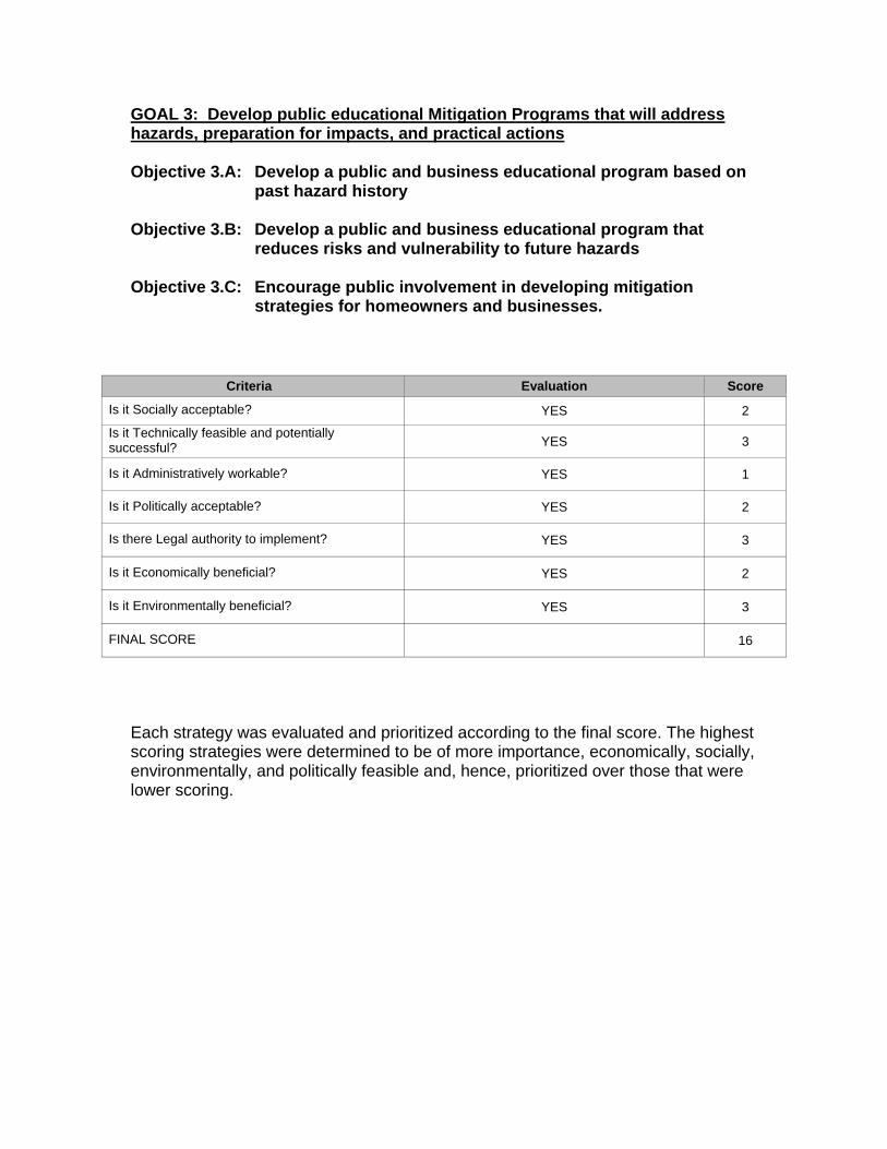
GOAL 3: Develop public educational Mitigation Programs that will address hazards, preparation for impacts, and practical actions Objective 3.A: Develop a public and business educational program based on
past hazard history Objective 3.B: Develop a public and business educational program that
reduces risks and vulnerability to future hazards Objective 3.C: Encourage public involvement in developing mitigation
strategies for homeowners and businesses.
Criteria Evaluation Score
Is it Socially acceptable? YES 2
Is it Technically feasible and potentially successful? YES 3
Is it Administratively workable? YES 1
Is it Politically acceptable? YES 2
Is there Legal authority to implement? YES 3
Is it Economically beneficial? YES 2
Is it Environmentally beneficial? YES 3
FINAL SCORE 16
Each strategy was evaluated and prioritized according to the final score. The highest scoring strategies were determined to be of more importance, economically, socially, environmentally, and politically feasible and, hence, prioritized over those that were lower scoring.

5-4 MITIGATION ACTIONS GOAL 1: Reduce the impacts and losses from identified hazards Objective 1.A: Address the following specific hazards by developing a set of mitigation actions: a. Flooding b. Severe Weather to include tornadoes, winter storms, thunderstorms, and hurricanes c. Wildfires Objective 1.B: Protect critical facilities and infrastructure MITIGATION ACTION 1: Amelia County has recognized that allowing new development in the floodplain is not acceptable and has already implemented a Zoning Ordinance prohibiting construction. There are properties along the Appomattox River that are prone to river flooding. If funding is received, Amelia would like to elevate and relocate homes or critical infrastructures out of the locality’s flood zones. Amelia County will meet every year to revise and implement zoning ordinances, regulations, etc. The County’s Wastewater Treatment Plant is not located in the floodplain however it is near a creek that during significant rainfall periods is prone to flooding. Amelia County has developed a plan to construct a new Wastewater Treatment Plant at another location to increase its capabilities and eliminate the potential of flooding. This plan is included in the County’s Capital Improvement Plan. The County would like to construct waterproof barriers at this facility to prevent future flood damages if the future relocation plan does not eliminate the hazard soon enough. MITIGATION ACTION 2: The Hazard Mitigation Planning Committee recognizes severe weather as a critical hazard. Amelia County would like to reduce the affects of severe weather on mobile homes by securing them beyond standard tie-downs to reduce their vulnerability to high winds. The County would like to install window clips for mounting plywood or install hurricane shutters to protect windows of critical facilities. Safe rooms and severe weather shelters in residential areas and large businesses have been accepted by the County as a method of providing safer locations for the public during rapid developing weather events. MITIGATION ACTION 3: Often during a disaster, the ability to maintain effective communications is threatened or destroyed. Amelia County needs to build redundant communications system components to back-up primary communications. A stand-by repeater is being considered with emergency power for public-safety communications systems.

This repeater should be remotely located from the existing tower to reduce the probability of the hazard that eliminated the primary site also eliminating the back-up site. The county water tower in the village is being considered as an appropriate site. MITIGATION ACTION 4: Since many of the residential homes in Amelia are located in rural areas of the County, they are potential exposed to wildland fires and will require protection. When new homes are constructed, information will be provided to encourage clearing trees, brush, and other flammable natural materials a safe distance from the home creating a “Green Zone” between the forest and the structures. The Virginia Department of Forestry will be contacted to provide wildland interface material that will assist in this action. GOAL 2: Strengthen mitigation goal implementation role and effectiveness of Emergency Management and improve Emergency Management’s capabilities Objective 2.A: Improve mitigation capabilities on a local level Objective 2.B: Improve mitigation capabilities on a regional level MITIGATION ACTION 1: Maintaining enough trained staff to manage mitigation strategies as well as emergencies on the local level is critical to successful implementation of mitigation goals and emergency operations. Current staffing levels must be evaluated. Amelia County recognizes the need to respond to the communities needs as the County continues to experience future growth in order to insure new mitigation goals are developed and implemented as this growth occurs. MITIGATION ACTION 2: Many of the mitigation goals and strategies are either the responsibility of Emergency Management personnel to implement or to monitor the progress of other personnel assigned to implementation. The current Emergency Operations Center does not provide the Emergency Management personnel with the appropriate abilities to properly track, document, and record the effects of disaster events so that mitigation strategies can be modified or added to the existing mitigation plan. This is essential for “growing” the plan based on future events and making necessary improvements to mitigate future events as the county experiences rapid growth in population and structures. The County would like to relocate their Emergency Operations Center to the County Administration Building. The expected growth and expansion of County services and staffing resources will require a larger facility. Hurricane shutters or window clips will be required to protect the new facility. The result of this relocation will require computer and communications capabilities along with additional personnel to provide the ability to track, record, and document the affects of events on the County to modify and update the mitigation plan.

MITIGATION ACTION 3: Mitigation strategies and goals for the county in many cases involve hazard risks that involve the entire region. Emergency Management personnel will coordinate and plan with other jurisdictions in the region. Mitigation strategies will be compared regionally and modified to make local improvements. GOAL 3: Develop public educational Mitigation Programs that will address hazards, preparation for impacts, and practical actions Objective 3.A: Develop a public and business educational program based on
past hazard history Objective 3.B: Develop a public and business educational program that
reduces risks and vulnerability to future hazards Objective 3.C: Encourage public involvement in developing mitigation
strategies for homeowners and businesses. MITIGATION ACTION 1: Information from this plan will be provided to residents and businesses through the local newspaper, inserted in tax bills or regular mailings to all addresses, and in public meetings. The public can develop an expectation of future events and the impact on the County by providing historical information about specific event types. MITIGATION ACTION 2: Developing recommended actions to take during hazardous events will be distributed. The County will provide recommended methods of reducing risk and vulnerability on the County’s website. Educational brochures will be developed and distributed to all school children to be taken home to parents. MITIGATION ACTION 3: The County will contact civic organizations, church organizations, and business groups to develop a Safe Community Committee. The County will facilitate the committee to develop recommendations for improving safety in the community and providing recommendations to provide educational information on a County-wide basis. This committee will be guided to develop recommendations that will plan for the future growth planned for the County. CHAPTER 6 - PLAN IMPLEMENTATION AND MAINTENANCE
Recognizing that many mitigation projects are ongoing, and that while in the implementation stage communities may suffer budget cuts, experience staff

turnover, or projects may fail all together, a good plan needs to provide for periodic monitoring and evaluation of its successes and failures and allow for updates of the Mitigation Plan where necessary.
6-1 Maintenance and Update of the Amelia County Hazard Mitigation Plan
In order to track progress and update the Mitigation Strategies identified in the Action Plan (Chapter 4), it is recommended that the County revisit the Hazard Mitigation Plan after a major event to assess its effectiveness. The Plan needs to be updated at least once every five years. The Emergency Management Director is responsible for initiating this review and needs to consult with members of the Hazard Mitigation Team and as needed with the Local Emergency Planning Committee and the community.
Changes should be made to the Mitigation Plan to accommodate for projects that have failed or are not considered feasible after a review for their consistency with STAPLEE, the timeframe, the community’s priorities, and funding resources. Priorities that were not ranked high, but identified as potential mitigation strategies, should be reviewed as well during the monitoring and update of this plan to determine feasibility of future implementation.
6-2 Continued Public Involvement
In keeping with the process of adopting the 2004 County of Amelia Hazard Mitigation Plan, the Emergency Management Director will be responsible for ensuring that the County Departments and the public have adequate opportunity to participate in the maintenance and update of the Hazard Mitigation Plan. A public hearing will be held to receive public comments during the annual review period.
During the maintenance and update process of the Hazard Mitigation Plan, the following techniques may be used to ensure continued public involvement:
Provide personal invitations to the Board of Supervisors
Provide personal invitations to personnel involved in the Budget and CIP Process
Provide personal invitations to the County Department heads
Post notices of meetings at the Courthouse, Library, and the County website
Conduct surveys to gather information and concerns from residents
Conduct surveys to gather information and concerns from residents
Submit public service announcements and community event announcements to
the “Amelia Bulletin” (local newspaper)
The Emergency Management Director and the Hazard Mitigation Team reserve the right to determine which of the above mentioned techniques and/or additional

outreach and public involvement methods will be used to maintain and update the Hazard Mitigation Plan.
6-3 Mitigation Plan Incorporation to Existing County Plans Amelia County Administration will review each of the recommendations and as a function of the implementation plan determine which recommended strategies can be incorporated into the County’s Comprehensive Plan, Zoning Plan, and Subdivision Plan. Each individual strategy can be added to the existing plans in the form of amendments and this process will provide for long-term and consistent implementation of the strategies. Amelia County plans to update the current Comprehensive Plan this year. This will give them the opportunity to incorporate the Mitigation Strategies into the Comprehensive Plan, Zoning Plan, and Subdivision Plan once adopted by the Board of Supervisors. Amelia County’s Comprehensive Plan is scheduled to be updated every five years which provides the opportunity to include new or revised mitigation strategies when updated. Public Hearings will be scheduled for the review and adoption of the Comprehensive Plan by the County Board of Supervisors. The Hazard Mitigation Annex X of the Emergency Operations Plan will be revised to include the hazard ratings and strategies as well as any other sections of the Mitigation Plan that applies to the EOP. In addition, this Hazard Mitigation Plan will be adopted as an Appendix to the existing Emergency Operations Plan. This action ensures the Hazard Mitigation Plan will be reviewed annually. The annual review includes a citizen comment and recommendation period, review by the Local Emergency Planning Committee (LEPC), and County Staff. CHAPTER 7 - IMPLEMENTATION PLAN
This step involves developing an action plan that outlines who is responsible for implementing each of the prioritized strategies determined in the previous step, as well as when and how the actions will be implemented. The following questions were asked to develop an implementation schedule for the identified priority mitigation strategies: WHO? Who will lead the implementation efforts? Who will put together funding requests and applications to include possible grants? WHEN? When will these actions be implemented, and in what order? HOW? How will the community fund these projects?
How will the community implement these projects? What resources will be needed to implement these projects?
The FEMA/VDEM Recommended Mitigation Action format was utilized to present recommendations to the mitigation committee for input and comments. This validation process was utilized to optimize productivity by providing the committee a guide that allowed them to make changes where necessary. The results of the committee involvement are included below in each action item. The categories added to the Goals and Action Items include:
• Responsible Office / Person • Priority (Based on High, Medium, Low) • Cost Estimate • Community Benefit • Potential Funding • Schedule

GOAL 1: Reduce the impacts and losses from identified hazards Objective 1.A: Address the following specific hazards by developing a set of mitigation actions: a. Flooding b. Severe Weather to include tornadoes, winter storms, thunderstorms, and hurricanes c. Wildfires Objective 1.B: Protect critical facilities and infrastructure MITIGATION ACTION 1: Amelia County has recognized that allowing new development in the floodplain is not acceptable and has already implemented a Zoning Ordinance prohibiting construction. There are properties along the Appomattox River that are prone to river flooding. If funding is received, Amelia would like to elevate and/or relocate homes or critical infrastructures out of the locality’s flood zones. Amelia County will meet every year to revise and implement zoning ordinances, regulations, etc. The County’s Wastewater Treatment Plant is not located in the floodplain however it is near a creek that during significant rainfall periods is prone to flooding. Amelia County has developed a plan to construct a new Wastewater Treatment Plant at another location to increase its capabilities and eliminate the potential of flooding. This plan is included in the County’s Capital Improvement Plan. The County would like to construct waterproof barriers at this facility to prevent future flood damages if the future relocation plan does not eliminate the hazard soon enough. Responsibility County Building Inspector; County Wastewater Plant Manager Priority Medium Cost Estimate $200,000 Community Benefit Prevention of Repetitive Losses, Maintaining Wastewater
System Potential Funding PDM and HMGP Funding, County Capital Budget Schedule Within 5 years MITIGATION ACTION 2: The Hazard Mitigation Planning Committee recognizes severe weather as a critical hazard. Amelia County would like to reduce the affects of severe weather on mobile homes by securing them beyond standard tie-downs to reduce their vulnerability to high winds. The County would like to install window clips for mounting plywood or install hurricane shutters to protect windows of critical facilities. Safe rooms and severe weather shelters in residential areas and large businesses have been accepted by the County as a method of providing safer locations for the public during rapid developing weather events.

Responsibility Emergency Management Officials, Building Officials, Private Citizens, Local Industry and Businesses
Priority Medium Cost Estimate $750,000 Community Benefit Life Safety, Loss Reduction, Public Education Potential Funding County Budget, Local Business Funding Schedule Within 3 years MITIGATION ACTION 3: Often during a disaster, the ability to maintain effective communications is threatened or destroyed. Amelia County needs to build redundant communications system components to back-up primary communications. A stand-by repeater is being considered with emergency power for public-safety communications systems. This repeater should be remotely located from the existing tower to reduce the probability of the hazard that eliminated the primary site also eliminating the back-up site. The county water tower in the village is being considered as an appropriate site. Responsibility Emergency Management Officials, County Staff Priority High Cost Estimate $50,000 Community Benefit Life Safety, Maintained ability to provide services to the public Potential Funding Homeland Security Grants, Radio Interoperability Grants Schedule Within 3 years MITIGATION ACTION 4: Since many of the residential homes in Amelia are located in rural areas of the County, they are potential exposed to wildland fires and will require protection. When new homes are constructed, information will be provided to encourage clearing trees, brush, and other flammable natural materials a safe distance from the home creating a “Green Zone” between the forest and the structures. The Virginia Department of Forestry will be contacted to provide wildland interface material that will assist in this action. Responsibility Emergency Management Officials, Building Official, Virginia
Department of Forestry Priority High Cost Estimate $0, Brochures are already available from the Va. Dept. of
Forestry Community Benefit Reduced losses Potential Funding Existing budget Schedule Within 3 years

GOAL 2: Strengthen mitigation goal implementation role and effectiveness of Emergency Management and improve Emergency Management’s capabilities Objective 2.A: Improve mitigation capabilities on a local level Objective 2.B: Improve mitigation capabilities on a regional level MITIGATION ACTION 1: Maintaining enough trained staff to manage mitigation strategies as well as emergencies on the local level is critical to successful implementation of mitigation goals and emergency operations. Current staffing levels must be evaluated. Amelia County recognizes the need to respond to the communities needs as the County continues to experience future growth in order to insure new mitigation goals are developed and implemented as this growth occurs. Responsibility Emergency Management Officials Priority Medium Cost Estimate Use existing staff ($0) or add staff - $30,000 per year Community Benefit Life Safety Potential Funding County Budget, VDEM Schedule Within 2 years MITIGATION ACTION 2: Many of the mitigation goals and strategies are either the responsibility of Emergency Management personnel to implement or to monitor the progress of other personnel assigned to implementation. The current Emergency Operations Center does not provide the Emergency Management personnel with the appropriate abilities to properly track, document, and record the effects of disaster events so that mitigation strategies can be modified or added to the existing mitigation plan. This is essential for “growing” the plan based on future events and making necessary improvements to mitigate future events as the county experiences rapid growth in population and structures. The County would like to relocate their Emergency Operations Center to the County Administration Building. The expected growth and expansion of County services and staffing resources will require a larger facility. Hurricane shutters or window clips will be required to protect the new facility. The result of this relocation will require computer and communications capabilities along with additional personnel to provide the ability to track, record, and document the affects of events on the County to modify and update the mitigation plan. Responsibility Emergency Management Officials Priority High Cost Estimate $10,000 Community Benefit Life Safety Potential Funding County Budget, Homeland Security Grants Schedule Within 3 years

MITIGATION ACTION 3: Mitigation strategies and goals for the county in many cases involve hazard risks that involve the entire region. Emergency Management personnel will coordinate and plan with other jurisdictions in the region. Mitigation strategies will be compared regionally and modified to make local improvements. Responsibility Emergency Management Officials Priority High Cost Estimate Staff Time Only ($0) Community Benefit Life Safety Potential Funding None Expected Schedule Within 2 years GOAL 3: Develop public educational Mitigation Programs that will address hazards, preparation for impacts, and practical actions Objective 3.A: Develop a public and business educational program based on
past hazard history Objective 3.B: Develop a public and business educational program that
reduces risks and vulnerability to future hazards Objective 3.C: Encourage public involvement in developing mitigation
strategies for homeowners and businesses. MITIGATION ACTION 1: Information from this plan will be provided to residents and businesses through the local newspaper, inserted in tax bills or regular mailings to all addresses, and in public meetings. The public can develop an expectation of future events and the impact on the County by providing historical information about specific event types. Responsibility Emergency Management Officials and County Staff Priority Medium Cost Estimate $500 per year Community Benefit Life Safety and Reduced Losses Potential Funding County Budget, Homeland Security Grants, VDEM Grants Schedule Within 3 years MITIGATION ACTION 2: Developing recommended actions to take during hazardous events will be distributed. The County will provide recommended methods of reducing risk and vulnerability on the County’s website. Educational brochures will be developed and distributed to all school children to be taken home to parents.

Responsibility Emergency Management Officials and County Staff Priority Medium Cost Estimate Web costs included with current contract, brochures $1,000 Community Benefit Life Safety and Reduced Losses Potential Funding County Budget, Homeland Security Grants, VDEM Grants Schedule Within 3 years MITIGATION ACTION 3: The County will contact civic organizations, church organizations, and business groups to develop a Safe Community Committee. The County will facilitate the committee to develop recommendations for improving safety in the community and providing recommendations to provide educational information on a County-wide basis. This committee will be guided to develop recommendations that will plan for the future growth planned for the County. Responsibility Emergency Management Officials and County Staff Priority Medium Cost Estimate Staff Time Only ($0), Public Notice Publication costs $100.00 Community Benefit Medium Potential Funding County Budget Schedule Within 3 years CHAPTER 8 – IMPLEMENTATION SCHEDULE
The following recommendations have been provided to assist the County of Amelia in adopting mitigation strategies in the community. Additions, deletions, changing the order of importance (ranking) are examples of Plan maintenance activities. (Update at least annually)
RECOMMENDATIONS TO BE ACCOMPLISHED IN 2 YEAR IMPLEMENTATION PLAN
GOAL OBJECTIVE MITIGATION ACTION PRIORITY ACTION
Goal 2 2.A 1 Medium
Maintaining enough trained staff to manage mitigation strategies as well as emergencies on the local level is critical to successful implementation of mitigation goals and emergency operations. Current staffing levels must be evaluated. Amelia County recognizes the need to respond to the communities needs as the County continues to experience future growth in order to insure new mitigation goals are developed and implemented as this growth occurs.

Goal 2 2.B 2 High
Many of the mitigation goals and strategies are either the responsibility of Emergency Management personnel to implement or to monitor the progress of other personnel assigned to implementation. The current Emergency Operations Center does not provide the Emergency Management personnel with the appropriate abilities to properly track, document, and record the effects of disaster events so that mitigation strategies can be modified or added to the existing mitigation plan. This is essential for “growing” the plan based on future events and making necessary improvements to mitigate future events as the county experiences rapid growth in population and structures. The County would like to relocate their Emergency Operations Center to the County Administration Building. The expected growth and expansion of County services and staffing resources will require a larger facility. Hurricane shutters or window clips will be required to protect the new facility. The result of this relocation will require computer and communications capabilities along with additional personnel to provide the ability to track, record, and document the affects of events on the County to modify and update the mitigation plan.
Goal 2 2.B 3 HIGH
Mitigation strategies and goals for the county in many cases involve hazard risks that involve the entire region. Emergency Management personnel will coordinate and plan with other jurisdictions in the region. Mitigation strategies will be compared regionally and modified to make local improvements.
RECOMMENDATIONS TO BE ACCOMPLISHED IN 3 YEAR IMPLEMENTATION PLAN
GOAL OBJECTIVE MITIGATION ACTION PRIORITY ACTION
Goal 1 1.A 2 Medium
The Hazard Mitigation Planning Committee recognizes severe weather as a critical hazard. Amelia County would like to reduce the affects of severe weather on mobile homes by securing them beyond standard tie-downs to reduce their vulnerability to high winds. The County would like to install window clips for mounting plywood or install hurricane shutters to protect windows of critical facilities. Safe rooms and severe weather shelters in residential areas and large businesses have been accepted by the County as a method of providing safer

locations for the public during rapid developing weather events.
Goal 1 1.A 4 High
Since many of the residential homes in Amelia are located in rural areas of the County, they are potential exposed to wildland fires and will require protection. When new homes are constructed, information will be provided to encourage clearing trees, brush, and other flammable natural materials a safe distance from the home creating a “Green Zone” between the forest and the structures. The Virginia Department of Forestry will be contacted to provide wildland interface material that will assist in this action.
Goal 1 1.B 3 High
Often during a disaster, the ability to maintain effective communications is threatened or destroyed. Amelia County needs to build redundant communications system components to back-up primary communications. A stand-by repeater is being considered with emergency power for public-safety communications systems. This repeater should be remotely located from the existing tower to reduce the probability of the hazard that eliminated the primary site also eliminating the back-up site. The county water tower in the village is being considered as an appropriate site.
Goal 3 3.A 1 Medium
Information from this plan will be provided to residents and businesses through the local newspaper, inserted in tax bills or regular mailings to all addresses, and in public meetings. The public can develop an expectation of future events and the impact on the County by providing historical information about specific event types.
Goal 3 3.B 2 Medium
Developing recommended actions to take during hazardous events will be distributed. The County will provide recommended methods of reducing risk and vulnerability on the County’s website. Educational brochures will be developed and distributed to all school children to be taken home to parents.
Goal 3 3.C 3 Medium
The County will contact civic organizations, church organizations, and business groups to develop a Safe Community Committee. The County will facilitate the committee to develop recommendations for improving safety in the community and providing recommendations to provide educational information on a County-wide basis. This committee will be guided to develop recommendations that will plan for the future growth planned for the County.

RECOMMENDATIONS TO BE ACCOMPLISHED IN 5 YEAR IMPLEMENTATION PLAN
GOAL OBJECTIVE MITIGATION ACTION PRIORITY ACTION
Goal 1 1.A 1 Medium
Amelia County has recognized that allowing new development in the floodplain is not acceptable and has already implemented a Zoning Ordinance prohibiting construction. There are properties along the Appomattox River that are prone to river flooding. If funding is received, Amelia would like to elevate and relocate homes or critical infrastructures out of the locality’s flood zones. Amelia County will meet every year to revise and implement zoning ordinances, regulations, etc. The County’s Wastewater Treatment Plant is not located in the floodplain however it is near a creek that during significant rainfall periods is prone to flooding. Amelia County has developed a plan to construct a new Wastewater Treatment Plant at another location to increase its capabilities and eliminate the potential of flooding. This plan is included in the County’s Capital Improvement Plan. The County would like to construct waterproof barriers at this facility to prevent future flood damages if the future relocation plan does not eliminate the hazard soon enough.
APPENDIX A - MAPS

MAP 1 - Location Map of Amelia County, Virginia and Surrounding Jurisdictions
MAP PROVIDED BY NOAA COASTAL SERVICES CENTER
AMELIA

MAP 2 - VIRGINIA DEPARTMENT OF TRANSPORTATION ROAD MAP OFAMELIA COUNTY MAP PROVIDED BY THE VIRGINIA DEPARTMENT OF TRANSPORTATION MAP AVAILABLE IN LARGER, FOLDING VERSION AT THE END OF THIS APPENDIX

MAP 3 - NORFOLK SOUTHERN RAILWAY MAP
MAP PROVIDED BY THE NATIONAL ATLAS OF THE UNITED STATES
AMELIA COUNTY
NORFOLK SOUTHERN RAILWAY

MAP 4 - PLANTATION PIPELINE LOCATION IN AMELIA COUNTY
MAP PROVIDED BY THE VIRGINIA DEPARTMENT OF TRANSPORTATION LOCATION OF PIPELINE PROVIDED BY PLANTATION PIPELINE REGIONAL SUPERVISOR
PLANTATION PIPELINE

MAP 8 – MAP OF DAMS IN AMELIA COUNTY AND SURROUNDING JURISDICTIONS
MAP PROVIDE BY THE NATIONAL INVENTORY OF DAMS THROUGH THE ARMY CORPS OF ENGINEERS
DAM HAZARD CLASSIFICATIONS
HIGH HAZARD
SIGNIFICANT HAZARD
LOW HAZARD
ALL AMELIA COUNTY DAMS ARE LOW HAZARD DAMS AND ALL SHOWN
ON THIS MAP ARE LOCATED ON CREEKS.
AMELIA COUNTY
DAMS IN SURROUNDING
JURISDICTIONS ARE INCLUDED TO SHOW
THEY DO NOT POSE A THREAT TO AMELIA
COUNTY

MAP 9 - HURRICANE AND TROPICAL STORM TRACKS IN VIRGINIA
MAP MADE AVAILABLE FROM THE GENERAL VIRGINIA MITIGATION PLAN HIRA
AMELIA COUNTY

MAP 10 - HURRICANE HAZEL 10/15/1954 MAP 11 - HURRICANE CAMILLE 08/17/1969
MAP 12 - TROPICAL STORM ISABEL 09/18/2003
MAPS PROVIDED BY
NOAA COASTAL SERVICES CENTER
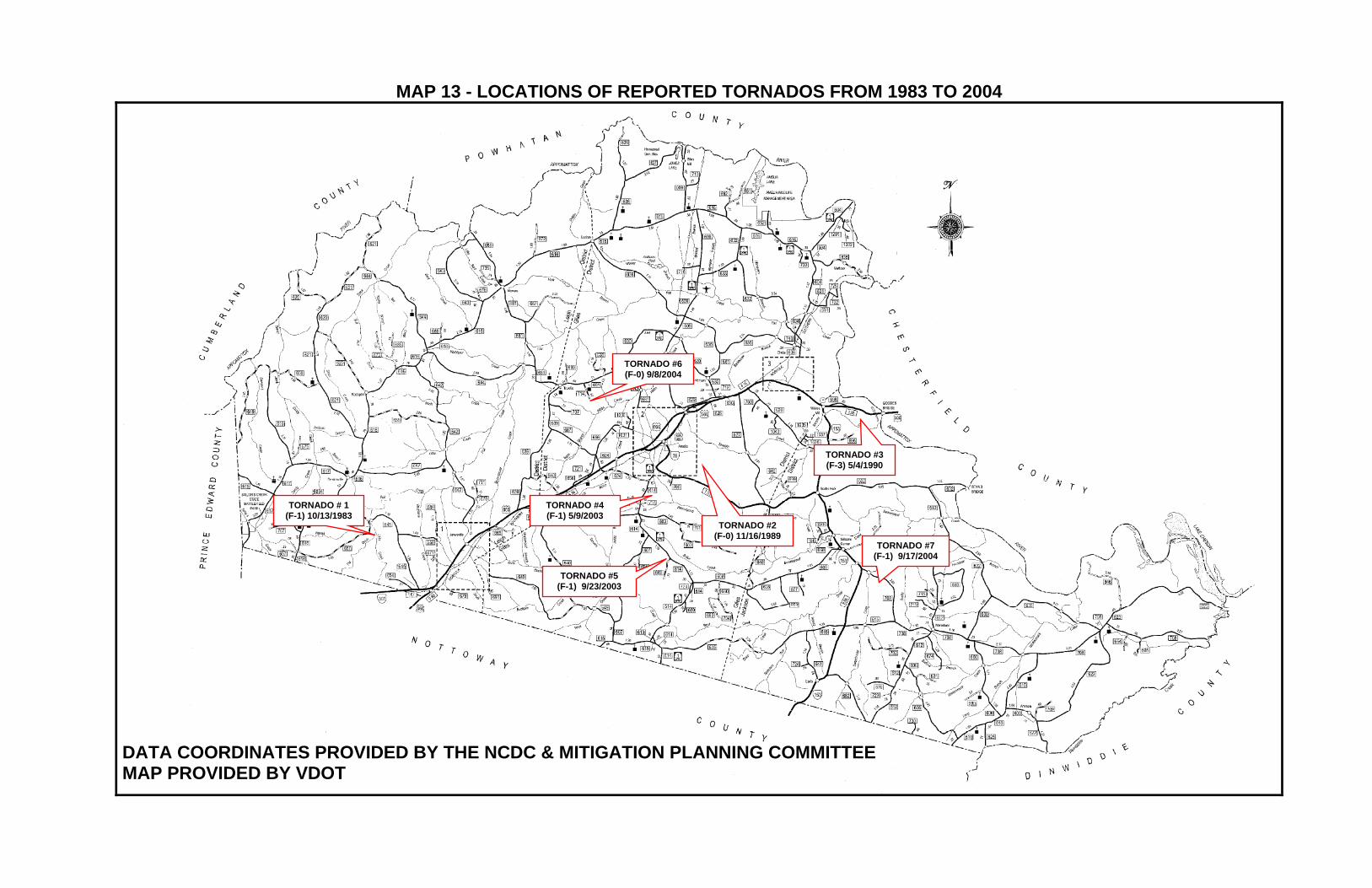
MAP 13 - LOCATIONS OF REPORTED TORNADOS FROM 1983 TO 2004
TORNADO # 1 (F-1) 10/13/1983
TORNADO #2 (F-0) 11/16/1989
TORNADO #3 (F-3) 5/4/1990
TORNADO #4 (F-1) 5/9/2003
TORNADO #5 (F-1) 9/23/2003
TORNADO #6 (F-0) 9/8/2004
TORNADO #7 (F-1) 9/17/2004
DATA COORDINATES PROVIDED BY THE NCDC & MITIGATION PLANNING COMMITTEE MAP PROVIDED BY VDOT

MAP 17 - USGS MAP OF DECEMBER 9, 2003 EARTHQUAKE NEAR COLUMBIA, VA
SOURCE: USGS
AMELIA COUNTY

MAP 18 – FIRE RANK IN VIRGINIA
FIRE RANK IN VIRGINIA ACQUIRED FROM THE VIRGINIA MITIGATION PLAN HIRA
AMELIA COUNTY

MAP 20 – POPULATION DENSITY IN 1990 MAP 21 - POPULATION DENSITY IN 2000
This map is provided by the Virginia Department of Forestry and shows a medium population density primarily located on the Route 360 corridor and the Amelia Courthouse area of the County.
This map is provided by the Virginia Department of Forestry and shows a medium population density that has grown in the year 2000 beyond the Route 360 corridor and the Amelia Courthouse area of the County. These areas are rural areas that are heavily wooded and difficult to access.

MAP 22 – WILDLAND INTERFACE MAP OF AMELIA COUNTY
GRAYED AREAS SHOW PRIMARY POPULATION AREAS, SOURCE: VA. DEPT. OF FORESTRY
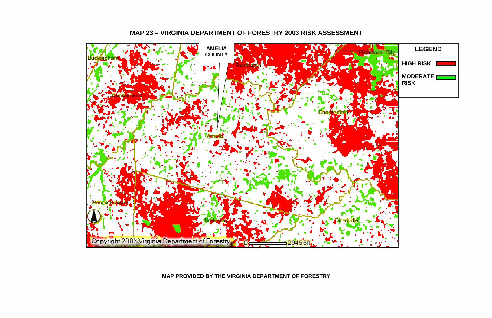
MAP 23 – VIRGINIA DEPARTMENT OF FORESTRY 2003 RISK ASSESSMENT
MAP PROVIDED BY THE VIRGINIA DEPARTMENT OF FORESTRY
AMELIA COUNTY
LEGEND
HIGH RISK MODERATE RISK

MAP 24 – HISTORICAL FIRE DATA PROVIDED BY VIRGINIA DEPARTMENT OF FORESTRY SINCE 1985
MAP PROVIDED BY THE VIRGINIA DEPARTMENT OF FORESTRY The Virginia Department of Forestry has verified that the data points in the above map represent reported forest fires from 1985 to 2003 that were reported by the local forester. This map does not include all fires that occurred in the time period and the areas noted on the map by red notations represent the general area the fires occurred. There are no records available that provide a more accurate or up-to-date record of forest related fires for the County.

MAP 25 – AMELIA COUNTY CRITICAL FACILITIES AND AREAS OF CONCERN (NOT INCLUDING THE VILLAGE OF AMELIA COURTHOUSE)
4
8 38
9
10
11
19
20
2621
22
23
33
25
32
39
40
41
528
LEGEND 4 – Public Safety Communications Tower 5 – County Sewage Treatment Plant 8 – Fire Station #2 9 – Fire Station #3 10 – Fire Station #4 11 – Fire Station #5 19 – Ingleside (Cedar Grove) 20 – Grubb Hill Church 21 – Father John Tabb’s Monument 22 – Egglesetton Plantation 23 – The Wigwam (Governor Giles Home) 24 – Haw Branch 25 – Dykeland 26 – Winterham 28 – Gambro Health Care Center 32 – Virginia Veteran’s Cemetery 33 – Saylers Creek Battlefield State Park 38 – Mannboro Medical Center 39 – Industrial Park 40 A, B, C – Landfills 41 - Railway * 34- Route of Lee’s Retreat follows roadways through the county and has historic value but no structures that could result in monetary loss, therefore it is not show on this map.

MAP 26 – AMELIA COUNTY CRITICAL FACILITIES AND AREAS OF CONCERN IN THE VILLAGE OF AMELIA COURTHOUSE
6
29
7
12 27
1614
35
15 36
13
18 1
31
37
302
17
PATRICK HENRY HIGHWAY
CHURCH ST.
DUNN ST.
WAYSIDE AVE.
GOODES BRIDGE ROAD
VIRGINIA ST.
N. FIVE FORKS RD.
WASHINGTON ST
COURT ST.
EGGLESTON ST. OTTERBURN RD.
ZION HILL LN.
LEIDIG ST.
CROWDER ST.
AMELIA ST. PRIDESVILLE RD.
LEGEND
1 – County Administration Building 2/3 – County Courthouse and Sheriff’s Office 6 – Water Tank 7 – Fire Station #1 12 – Amelia Rescue Squad 13 – Amelia Nursing Home 14 – Amelia High School 15 – Amelia Middle School 16 – Amelia Elementary School 17 – Amelia Academy 18 – Love Covenant School 27 – Amelia Medical Center 29 – Hope Chapel Day Care Center 30 – Amelia Baptist Church Day Care 31 – James L. Hamner Public Library 35 – Amelia County Park 36 – Apartment Complex 37 – Apartment Complex * Box 2 indicates the location of facility #2 and #3 which or in the same building. The County Sheriff’s Office is located in the County Courthouse along with the Emergency Communications Center and shown on this map as #2.

MAP 27 – AMELIA COUNTY CRITICAL FACILITIES AND AREAS OF CONCERN IN THE VILLAGE OF AMELIA COURTHOUSE
LEGEND
1 – County Administration Building 2 – County Courthouse and Sheriff’s Office 18 – Love Covenant School 30 – Amelia Baptist Church Day Care 31 – James L. Hamner Public Library 37 – Apartment Complex * #2 indicates the location of facility #2 and #3 which or in the same building. The County Sheriff’s Office is located in the County Courthouse along with the Emergency Communications Center and shown on this map as #2.

THIS PAGE LEFT BLANK INTENTIONALLY APPENDIX B
Public and Mitigation Committee Meeting Minutes
MEETING 1 MINUTES
MEETING 2 MINUTES
MEETING 3 MINUTES
MEETING 4 MINUTES
MEETING 5 MINUTES
MEETING 6 MINUTES
MEETING 7 MINUTES
MEETING 8 MINUTES


Amelia County Hazard Mitigation Plan Public and Committee Meeting 1 April 4, 2005 1900 Hours Location: Amelia Administration Conference Room In Attendance: William Howlett, Ken Cochran, Don Bowman of Howlett and Associates, Inc., Philip T. Vannoorbeeck, County Administrator, Jay Flippin, Fire Department, Steve Binford, Fire Department, Kent Emerson, Health Department, Bonita Archer, VDOT • Mr. Howlett opened the meeting with an introduction of everyone in attendance. • A discussion was held explaining the reason the plan was needed and what the plan was
along with an expected completion date of September 1st. • A handout was provided to all in attendance with the proposed Plan Format for the attendants
review. • A brief review of what information is included in Amelia County’s Risk Assessment for the
County’s EOP was conducted which included a discussion of the moderate to high risk evaluation list.
• It was agreed by the committee that this list and levels of risk have not been validated. • The following is a summary of the committee’s suggestions of the biggest threats to Amelia
County: o Tornado – occurred in May of 2003 and spring of 2004 o Flooding – Mannboro area is more prone to flooding near Chesdin o Flooding – The Appomattox River would not be a factor except in low lying areas
near the banks. o Crop Damage – due to long durations of rain, drought, hail
• Jay Flippin suggested that we contact his dad for weather data history in Amelia. • It was determined that Kent Emerson would be the person to contact to convene a meeting of
the LEPC for Amelia to validate the background information provided in the Risk Assessment of the EOP.
• Once validated it would require a State approval • A discussion was held to determine the buildings that would be priorities for protection:
o The new addition to the Courthouse including the Communications Center o Saylor’s Creek Battlefield o Namozine Church o Grubb Hill Church o Haw Branch Plantation o Eggleston
• Sources of information for these buildings would be the Library and Historical Society. • Additional discussion was held to consider the following concerns:
o Wildland Fires – Use the Department of Forestry maps to determine areas of concern
o New Subdivisions – would need to be identified including a planned, 2100 home subdivision planned near the Courthouse with the County Administrator being the contact for this information
o Identifying New Growth – to determine the risks involved that have not yet been identified.
o Ice Storms – long-term residents are prepared to deal with the effects but with planned growth in the County, new residents would be as prepared.
• Ricky Gravely and Doug Augley are the local foresters. • Amelia is about 370 sq. miles • The Industrial Park should be included in the risk assessment since it contains a wood
processing plant (cabinet making).

• Agricultural concerns centered around the number of acres dedicated to crops that could be damaged by weather and Larry duty is the Agricultural Agent that could provide information and concerns.
• There are dairy farms to be considered also. • Hazardous Materials Concerns
o Pipeline o Railroad o Routes 360, 307, 153, 604
• Landfills o To include gas management systems o Flaring and generating electricity o There are three landfills o The main landfill o Eppes Lane that sparks automatically on Rt. 703, lined o Behind Scott Lumber, unmonitored and capped, unlined, Waste Management
helps with maintaining the cap • Bonita Archer of VDOT agreed to research grant availability through their agency for
mitigation. • Dams
o The impact a dam erosions was discussed o It was recommended that the Old Mill be considered o Steve Davis’s pond could contaminate a nearby well used as a local water
source. • The meeting was concluded with
o We can began developing the HIRA o We need to continue gathering the necessary information o Willie Howlett will gather the Sara Title III submittals from the County
Administrator o The HIRA will need to be reviewed by the LEPC o Then it would be submitted to the State for review and approval
The next planned meeting will be held during the first week of April inviting all the personnel involved in providing information for the HIRA.

Amelia County Hazard Mitigation Plan Mitigation LEPC Planning Team Meeting 2 May 24, 2005 1500 Hours Location: Amelia Administration Conference Room In Attendance:
William Howlett Howlett and Associates, Inc. Ken Cochran Howlett and Associates, Inc. Don Bowman Howlett and Associates, Inc. Kent Emerson Va. Department of Health Ray York Amelia County Jamie Surface Amelia County Planning Daray Howarth American Red Cross
• Mr. Howlett opened the meeting with an introduction of everyone in attendance. • Draft copies of the Mitigation Plan Document were distributed that showed attendees the
general layout of the topics that will be included and the sections that were being completed for the HIRA.
• Mr. Howlett reviewed the sections of the HIRA and requested input from the committee for information or contacts for each section:
o Page 9 – Department and Agencies to be included: Amelia Public Works All Amelia County Departments Waste Management from the Maplewood Landfill
o Page 11 - Natural and Manmade Hazards None added
o Page 17 – Maps Kent Emerson has ArcView capabilities on his computer but no access to
Amelia GIS maps. It was recommended that we contact Deputy Bruce Almerode with the
Amelia County Sheriff’s Office who does have access to Amelia County GIS.
o Page 30, 31, & 32 – Development Trends Jamie Surface with the Planning Department will provide the information
necessary to complete the sections on General Land Use Types and Land Use Classifications
o Page 36 – Past Hazard Events It was recommended that we research previous road closures due to
past hazard events and include them in the document. It was recommended that we contact VDOT District Supervisor Lisa
Asycue at 524-6000 for any information that they may have. Mr. Flippin has been identified as the contact for past weather related
incidents since he was the local data collector for the National Weather Service for several years.
Carol and Tim Smallwood of Smallwood’s Nursery on Chula Road may be contacted since they have taken over the responsibilities of collecting local weather data for the National Weather Service.
o Page 39 & 45 – Critical Facilities Other than the primary facilities to necessary to operate Government
Services and Public Safety Services, two apartment complexes were added to the list. One is located at Virginia Street across from the Post Office in the village.
o There were no additions to the Potential Resources and Risk Calculation Sections
There being no further business the meeting was adjourned.

Amelia County Hazard Mitigation Plan Public and Mitigation Planning Team Meeting 3 May 24, 2005 1900 Hours Location: Amelia Administration Conference Room In Attendance:
William Howlett Howlett and Associates, Inc. Ken Cochran Howlett and Associates, Inc. Don Bowman Howlett and Associates, Inc. Philip T. Vannoorbeeck Amelia County Administrator Kent Emerson Va. Department of Health Hibak Hersi VDEM
• Mr. Howlett opened the meeting with an introduction of everyone in attendance. • Draft copies of the Mitigation Plan Document were distributed that showed attendees the
general layout of the topics that will be included and the sections that were being completed for the HIRA.
• Mr. Howlett reviewed the input on each of the sections for the HIRA from the previous meeting with the LEPC and asked for agreement and additions. The following list includes the original recommendations that were accepted by the Committee and some additions:
o Page 9 – Department and Agencies to be included: Amelia Public Works All Amelia County Departments Waste Management from the Maplewood Landfill Citizen’s Corps LEPC Educational Facility Managers Non-Profit Organizations
o Page 11 - Natural and Manmade Hazards Civil Unrests
o Page 17 – Maps Kent Emerson has ArcView capabilities on his computer but no access to
Amelia GIS maps. It was recommended that we contact Deputy Bruce Almerode with the
Amelia County Sheriff’s Office who does have access to Amelia County GIS.
o Page 30 & 31 – Development Trends Jamie Surface with the Planning Department will provide the information
necessary to complete the sections on General Land Use Types and Land Use Classifications
o Page 36 – Past Hazard Events It was recommended that we research previous road closures due to
past hazard events and include them in the document. It was recommended that we contact VDOT District Supervisor Lisa
Asycue at 524-6000 for any information that they may have. Mr. Flippin has been identified as the contact for past weather related
incidents since he was the local data collector for the National Weather Service for several years.
Carol and Tim Smallwood of Smallwood’s Nursery on Chula Road may be contacted since they have taken over the responsibilities of collecting local weather data for the National Weather Service.
Look for the potential of road closure and damage at the Old Mill Pond on Route 153.

Research previous damage to a railway at Courthouse Branch and Old Rt. 360 due to high water.
o Page 39 – Critical Facilities Other than the primary facilities to necessary to operate Government
Services and Public Safety Services, two apartment complexes were added to the list. One is located at Virginia Street across from the Post Office in the village.
The Pediatrician’s Office in the Food Lion Shopping Center Mannboro Clinic The Nursing Home in the Village The Industrial Park There are several wells that provide water supply to the Village
o There were no additions to the Potential Resources and Risk Calculation Sections
There being no further business the meeting was adjourned.

Amelia County Hazard Mitigation Plan Public and Mitigation Planning Team Meeting 4 October 11, 2005 1900 Hours Location: Amelia Administration Conference Room In Attendance:
William Howlett Howlett and Associates, Inc. Ken Cochran Howlett and Associates, Inc. Philip T. Vannoorbeeck Amelia County Administrator Kent Emerson Va. Department of Health
• The initial Critical Facilities list was reviewed and modified • The initial Areas of Concern list was reviewed and modified • Both list were left for Amelia County Administration to research building values • The Critical Facilities Hazard Rating Matrix was developed and initial ratings discussed • There being no further questions, comments, or business – the meeting was adjourned. • The next meeting is scheduled for December 13, 2005 at 1900 hours in the County
Administration Conference Room of Amelia County.

Amelia County Hazard Mitigation Plan Public and Mitigation Planning Team Meeting 5 November 8, 2005 1900 Hours Location: Amelia Administration Conference Room In Attendance:
William Howlett Howlett and Associates, Inc. Don Bowman Howlett and Associates, Inc. Philip T. Vannoorbeeck Amelia County Administrator Kent Emerson Va. Department of Health Jay Flippin County Fire Services Billy Smith VDOT Tamara Caldwell VDEM
• An emailed document was provided to members that did not have one and most had copies of their own. This document contained all the sections for past hazard histories and would be the agenda for the meeting. The purpose was to review for accuracy and provide input.
• Mr. Howlett asked for the members in attendance to introduce themselves • Mr. Bowman discussed a list of meeting participants that were personally invited to
attend to discuss specific sections of the mitigation plan that required their input. • Those that did not attend were the Historical Society and the Virginia Department of
Forestry. • Jay Flippin explained that his father did not attend since the document that was
emailed as the topics for discussion had been reviewed and the section that applied to weather events history had been reviewed by him and were more accurate that his records or recall.
• (Mr. Flippin had been the Amelia County weather data collector for the National Weather Service for many years and since retired.)
• Jay Flippin recommended contacting the local State Forester for the information required for the Wildfire section of the Plan.
• Billy Smith of VDOT provided a map of Amelia County and discussed the effects of flooding and other weather hazards on the roadways in Amelia County.
• Mr. Vannoorbeeck and Kent Emerson provided input and verification along with Jay Flippin on all other sections of the document.
• This included some changes to the Critical Facilities and Areas of Concern Matrix. Some Critical Facilities were moved to the Areas of Concern Section.
• Tamara Caldwell provided input on the process and recommendations for completion of the HIRA.
There being no further business, the meeting was adjourned. The next meeting is scheduled for December 13, 2005.

Amelia County Hazard Mitigation Plan Public and Mitigation Planning Team Meeting 6 December 13, 2005 1900 Hours Location: Amelia Administration Conference Room In Attendance:
William Howlett Howlett and Associates, Inc. Ken Cochran Howlett and Associates, Inc. Don Bowman Howlett and Associates, Inc. Philip T. Vannoorbeeck Amelia County Administrator Kent Emerson Va. Department of Health Jay Flippin County Fire Services Steve Binford Fire Department Tamara Caldwell VDEM
• Don Bowman opening the meeting with a brief review of where we are in the process • A detailed review of Development Trends was conducted
o A review of the Comprehensive Plan section that describes current growth potential in the Village of Amelia was conducted since a rezoning request has been filed that a developer has proposed a significant project to provide 2,000 residential lots in the village. This has the potential of doubling the population of the County over the next 8 years. All the details will be included in the Development Trends section of the Mitigation Plan.
o This information will also be included in the Development Potential section of the Plan which will include the issues of providing utilities to support the growth.
• Table 6- Natural Hazards Addressed in the Amelia County Mitigation Plan was reviewed and adopted as read. The discussion included how to develop the rating for the Relative Risk Category section. The committee agreed with the ratings.
• The Future Growth section of the Vulnerability Assessment section was reviewed and several additions were made to include Winter Storms, Hurricanes, Power Outages, and the increase potential for sheltering larger numbers of citizens based on the expected future growth.
• It was determined that the locations of the tornado occurrences listed with the NCDC were incorrect. A map from the Plan was utilized by the committee to place the exact locations of each tornado. This will be corrected in the document.
• All hazard occurrences were discussed and VDEM requested information on repetitive damages to locations as a result. It was determined that there are no hazards that have created repetitive damages in any case. It was also determined that damages that occurred in all hazards have been minimal.
• A detailed discussion was conducted with VDEM concerning the continuing issue of limited citizen involvement. A strategy was approved that will include a questionnaire being posted on the Amelia County website that allows responses from anyone accessing the website to the Committee by email. Questionnaires will be distributed to businesses and placed at public locations.
• It was determined that the Plan, Chapter 1-4 including the HIRA was complete and should be submitted to VDEM for review.
There being no further business, the meeting was adjourned with the next meeting being planned at a latter date to begin developing the mitigation strategies.

Amelia County Hazard Mitigation Plan Mitigation Planning Team Meeting 7 February 21, 2006 1900 Hours Location: Amelia Administration Conference Room In Attendance:
Ken Cochran Howlett and Associates, Inc. Don Bowman Howlett and Associates, Inc. Philip T. Vannoorbeeck Amelia County Administrator Ray York Amelia County Jay Flippin Amelia County Fire Services
• The meeting began with a review of the tasks to be accomplished: o Listing and evaluating current plans and ordinances o Brainstorming mitigation strategies and recommendations o Ranking the priority of the recommendations o Determining responsible personnel for implementation o Establishing timeframes for completion o Developing final implementation plan
• All the current County plans and ordinances were listed and discussed to determine those that related to mitigating damage from natural disasters
• Once identified, they were evaluated for their effectiveness and any areas were
identified where improvement was required • Mitigation strategies were discussed and developed • Those strategies were ranked and personnel were identified for implementation • Timeframes for completion of the recommendations were determined and approved • The final implementation plan was developed and approved
At this point, the committee approved all the sections of the Amelia County Hazard Mitigation Plan and approved the final document submittal to VDEM and FEMA. It was determined that any recommendations for changes in the document by VDEM or FEMA would be accomplished by Howlett and Associates with the approval of the County Administrator. There being no further business, the meeting was adjourned.

Amelia County Hazard Mitigation Plan Meeting with County Administration and Departments Meeting 8 June 22, 2006 1300 Hours Location: Amelia County Administration Office In Attendance:
Don Bowman Howlett and Associates, Inc. Philip T. Vannoorbeeck Amelia County Administrator Norma Duty Amelia County Assistant Administrator
• Copies of the Comprehensive Plan, Zoning Plan, and Subdivision Plan were
provided for a detailed review. • Mitigation strategies were identified with the assistance of the County
Administrator and reviewed to determine all had been located. • Previous discussions in earlier meetings were re-discussed to confirm the
effectiveness of the Plans. • The Planning Director and the Financial Director were also present but not
needed for any details for the Plan review. APPENDIX C
BUSINESS AND PUBLIC INPUT METHODS UTILIZED
PUBLIC MEETING NOTICES & INVITATIONS TO ADJOINING JURISDICTIONS
QUESTIONAIRE DISTRIBUTION
LETTER AND QUESTIONNAIRE
QUESTIONNAIRE RESULTS

1) Initial notice of public meeting to the public and businesses of Amelia County was accomplished by posting Legal Notices in The Amelia Bulletin Monitor, the local paper of Amelia County.
This notice was published in three additions of the paper prior to the April meeting.

2) Notification was made to all Amelia County Local Emergency Planning Committee members as well as all County Departments requesting their attendance and participation on the committee. 3) Letters were sent from the County Administrators Office to all adjoining jurisdictions inviting them to attend meetings or send comments that were relative to the mitigation efforts underway. 4) Notices were posted in local newspapers in all adjoining jurisdictions listing public meeting schedules for September, October, and November inviting all citizens and businesses wishing to provide input to attend the meetings. 5) A questionnaire was developed and distributed with a cover letter of explanation from the County Administrator. 1,000 questionnaires were distributed to all Amelia businesses licensed to conduct business in the County. The remaining questionnaires were placed at public locations for citizens to access such as the local Post Office, Library, County Administration Building, etc. This letter and questionnaire are included in the next two pages. 6) The questionnaire developed for distribution was added to the County’s website so that anyone wishing to provide comment could either fill out the questionnaire and submit it or send an email with their comments.

LETTER AND QUESTIONNAIRE January 5, 2006
Dear Amelia County Business: The County of Amelia is developing a hazard mitigation plan. Part of the process involves asking for feedback and input from business, industry, citizens, and surrounding jurisdictions. In order for the County, as well as public and private individuals and businesses to remain eligible for disaster funds, completion of this plan is a requirement of the Federal Government. Several meetings have been conducted to generate baseline data. That information is contained in the attached questionnaire. The Planning Team is requesting your assistance by completing this questionnaire and returning it in the postage paid envelope. If you would prefer, the questionnaire is available on-line and can be accessed at the Amelia County website. Any questionnaires and comments can be emailed to:
[email protected] By taking a few minutes of your valuable time you will help us validate information already gathered as well as making sure no important data is omitted. Thank you for your assistance. Philip Vannoorbeeck County Administrator Amelia County
Hazard Mitigation Survey
Amelia County is seeking input from citizens and businesses on the Amelia County Hazard Mitigation Plan. This plan is a requirement of the federal government to remain eligible for grants to help prepare for and recover from natural disasters. Your input is critical in capturing historical data as well as planning for the future. Please take time to respond to this survey. Thank you for your valuable input.
1. The Planning Team ranked the natural disasters listed below in the order they feel are most likely to impact Amelia County.
Do you: Agree ______ Disagree_______
Comments:
2. The Planning Team identified the following as critical facilities and areas of concern. Are there any you would add or delete?
You may write in additions you wish to add and strike through any you think should be deleted.
Critical Facilities Areas of Concern
Amelia County Administration Building
Amelia Medical Center
Amelia County Courthouse Gambro Health Care Center
Amelia County Sheriff Office Hope Chapel Day Care Center
Public Safety Communications Tower Ameri-Kids Day Care at Amelia Baptist Church
Amelia Sewage Treatment Plant James L. Hamner Public Library
Water Tank Virginia Veteran’s Cemetery
Fire Station #1 Saylers Creek Battlefield State Park
Fire Station #2 Route of Lee’s Retreat Fire Station # 3 Amelia County Park Fire Station # 4 Apartment Complex Fire Station # 5 Apartment Complex Amelia Rescue Squad Mannboro Medical Center
Type Hazard Degree of Threat High Medium Low Tornadoes X Wild Fires X Flooding X Hurricanes X Thunderstorms X Winter Storms X Drought X Earthquake X

Amelia Nursing Center Industrial Park Critical Facilities Areas of Concern
Amelia High School Landfills Amelia Middle School Railway Amelia Elementary School Amelia Academy Love Covenant School Ingleside (Cedar Grove) Grubb Hill Church Father John Bannister Tabb’s Monument
Egglesetton Plantation The Wigwam Home of Governor William B. Giles
Haw Branch Dykeland Winterham
3. How would you like to receive additional information about the development and revision of this Hazard Mitigation Plan?
Newspaper Direct Mail Internet E-mail Other (Please list)
4. Would you like additional information about how to make your home or business safer from disasters? Yes______ No_______ Comments:
5. Do you currently have a home or business disaster supply kit?
Yes______ No______
6. Would you be willing to attend meetings to assist in developing and revising the Hazard Mitigation Plan? Yes______ No______
7. Do you own or rent?
Own______ Rent_____
8. How long have you been in Amelia County? 1-5 Years 6-10 Years 11-15 Years 16-20 Years More then 20 years
Please provide any additional comments you think would be helpful in developing a comprehensive Hazard Mitigation Plan.

AMELIA MITIGATION PLAN SURVEY RESULTS
131 QUESTIONNAIRES RETURNED
QUESTION 1: HAZARD RANKING AND IMPACT AGREE: 65 DISAGREE: 2 BUT SHOW NO CHANGES TO BE MADE MOVE HURRICANES TO MEDIUM: 15 MOVE WINTER STORMS HIGHER: 13 MOVE DROUGHT HIGHER: 8 MOVE THUNDERSTORMS TO HIGH: 4 MOVE THUNDERSTORMS TO MEDIUM: 14 MOVE WILDFIRES TO HIGH: 1 MOVE WILDFIRES TO LOW: 2 MOVE TORNADOES TO HIGH: 3 MOVE TORNADOES TO MEDIUM: 1 MOVE FLOODING HIGHER: 2 MOVE EARTHQUAKES TO MEDIUM: 2 QUESTION 2: CRITICAL FACILITIES AND AREAS OF CONCERN LISTS AGREE: 88 THE FOLLOWING RECOMMENDATIONS WERE MADE:
Add transportation to shelter to area of concern
Routes 360, 604 and 609 at Appomattox River to areas of concern
19 say that parks, retreats, churches, monuments, plantations and historical structures
are not critical facilities
7 requests that all medical centers be moved to critical list
Request that Communications be #1; Police #2 and government #3 on the critical list
3 requests that all day cares and Amelia Head start/Preschool Complex be moved to
critical
Request that Fire Stations and Rescue squads be 1st on critical list
Historical Society be moved to critical due to documentation it contains

2 requests that parks, retreats, churches, monuments, plantations and historical
structures be moved to areas of concern
Add veterinarian clinics and Amelia Animal Shelter to critical
Add Namozine Church to list
Hope Chapel and AmeriKids mover to critical since no transportation
2 requests that railway, Post Office, VDOT be moved to critical
2 requests that restaurants and service stations be added to areas of concern
Put bridges, low-lying areas, homes of elderly/disabled as areas of concern
Add telephone and electric remote sites
Add Glenwood Farms and Southern States due to chemical factor
Remove Hope Chapel Day Care
Add Amelia Elder Homes as areas of concern
Add airport to areas of concern
Add handicapped, elder and trapped citizens to areas of concern
What are areas of concern?
Correction to list: ABC preschool of Amelia Baptist Church AmeriKids Day Care I & II QUESTION 3: How would you like to receive additional information about the development and revision of this Hazard Mitigation Plan? Newspapers – 53
Direct Mail – 24 with addresses attached
57 with no addresses
Internet – 8
E-Mail – 7 (3 with e-mail addresses)
E-mail addresses:
QUESTION 4: Would you like additional information about how to make your home or business safer from disasters? Yes – 79
No – 49

No response – 2
Need info on Bio-Terrorism
Interested in what to do after a disaster
QUESTION 5: Do you currently have a home or business disaster supply kit?
Yes – 41
No – 88
No response – 1
Please give information on what is needed for disaster kits (home and business)
1 person feels that the county should supply disaster kits to all homes
QUESTION 6: Would you be willing to attend meetings to assist in developing and revising the Hazard Mitigation Plan?
Yes – 51
No – 70
No response – 6
Question as to what committee does – 3
Would like to be involved:
Amelia Nursing and Rehabilitation Center, 8830 Virginia Street, Amelia 23002
Village Vet Service Inc., P. O. Box 167, Amelia 23002
Jim Glass, 12312 White Oak Lane, Amelia 23002 – military related experience in such
planning
QUESTION 7: Do you own or rent?
Own – 121
Rent – 1
Rent business location – 1
QUESTION 8: How long have you been in Amelia County? 1 – 5 years – 20
6 – 10 years – 15
11 – 15 years – 17
16 – 20 years – 13
More than 20 – 68

ADDITIONAL COMMENTS 1. Communication is key
2. Obtain expertise of a survey writer - # of flaws and your results could be challenged
3. More safe places to go closer to home
4. Underground stocked facility centrally located in county or in each district
5. Compare Amelia plan with other locals
6. What are criteria for adding and/or deleting critical facilities or areas of concern
7. Back up stores of fuel for vehicles and equipment
8. Small generators available for people on oxygen, etc. in case of long term power failure
9. When we had hurricanes no response to elderly people
10. When lights and electricity go out does the county have a list of people who need
oxygen, electricity or a tie line to EMT
11. Make a phone number available for all disasters to shut-ins and older people who
do not have help or readily available assistance, add $5.00 a year to all people in
county who can and make it an emergency fund – response would be good
12. Have rail cars sprinkled with lime to keep down sting and prevent flies and air born
diseases, from mold born bacteria being spread through wind and heavy traffic
13. Remove dead trees, repair potholes and broken road edges – VDOT is almost unseen
14. Stores should have generator backup for gas and food supplies
15. Generators for people and animal care centers
16. Have disaster supply kits available for purchase
17. Town meetings designed to educate and inform residents
18. Form committees to check on people who are shut-ins, elderly, disabled, etc.