
Amby Development, Inc.
56
Amby Development, Inc. 102 Enlglish Manor Phone: 912-748-8363 Guyton, GA 31312 Fax: 912-748-8386 TO: All Purchasers of Property in Stonegate Subdivision FROM: Amby Development, Inc. The development plan of Stonegate Subdivision incorporates three different sections; Pebblestone,Cobblestone and Ballastone. These are three different areas of the same development, all sharing the same Amenities and Common Areas and abiding by the same Declaration of Covenants and Restrictions. Basically, the only difference between the three sections is the lot sizes and the square footage requirements for the houses to be built in each section. One of the advantages of Stonegate Subdivision is the number of amenities that exist, both on Common Areas of the development and on adjacent lands which are made available to the Homeowners Association. Your ownership will make you a member of Stonegate Amenities, Inc., the Association which will hold title to all of the common areas within the subdivision as well as the items of property set forth in the Declaration of Covenants and Restrictions. The adjacent lands which are being made available to the Association contains a Lake and adjacent properties which can be used for camping and recreation. Also, there is an area adjacent to the Club House which is to be used for Recreation.. The Homeowners Association has use of this property for the purposes and under the conditions which are stated within the leases attached to the Declaration of Covenants and Restrictions. Special care should be taken of these areas so that the Association and its Members do not lose the use of these properties. Stonegate Subdivision is serviced by private water and sewer systems that are presently owned by Amby Development, Inc.. Additional utilities available will include Savannah Electric, Bell South and Comcast Cable. Stonegate will be serviced at the present time by mail delivery from the Bloomingdale, Georgia post office. A post office is also available for P0 Box delivery in the nearby community of Eden, Georgia. School age children from Stonegate Subdivision will attend the Sandhill Elementary School, South Effingham Middle School or South Effingham High School according to the present school districts, depending on their grade in school. All purchasers of any Lot within Stonegate Subdivision should obtain a copy of the Declaration of Covenants for this development for further information and understand all the terms and conditions contained in that document before purchasing. Receipt acknowledged this day of , 20 Purchaser
Transcript of Amby Development, Inc.

Amby Development, Inc. 102 Enlglish Manor Phone: 912-748-8363 Guyton, GA 31312 Fax: 912-748-8386
TO: All Purchasers of Property in Stonegate Subdivision
FROM: Amby Development, Inc.
The development plan of Stonegate Subdivision incorporates three different sections; Pebblestone,Cobblestone and Ballastone. These are three different areas of the same development, all sharing the same Amenities and Common Areas and abiding by the same Declaration of Covenants and Restrictions. Basically, the only difference between the three sections is the lot sizes and the square footage requirements for the houses to be built in each section.
One of the advantages of Stonegate Subdivision is the number of amenities that exist, both on Common Areas of the development and on adjacent lands which are made available to the Homeowners Association. Your ownership will make you a member of Stonegate Amenities, Inc., the Association which will hold title to all of the common areas within the subdivision as well as the items of property set forth in the Declaration of Covenants and Restrictions.
The adjacent lands which are being made available to the Association contains a Lake and adjacent properties which can be used for camping and recreation. Also, there is an area adjacent to the Club House which is to be used for Recreation.. The Homeowners Association has use of this property for the purposes and under the conditions which are stated within the leases attached to the Declaration of Covenants and Restrictions. Special care should be taken of these areas so that the Association and its Members do not lose the use of these properties.
Stonegate Subdivision is serviced by private water and sewer systems that are presently owned by Amby Development, Inc.. Additional utilities available will include Savannah Electric, Bell South and Comcast Cable.
Stonegate will be serviced at the present time by mail delivery from the Bloomingdale, Georgia post office. A post office is also available for P0 Box delivery in the nearby community of Eden, Georgia.
School age children from Stonegate Subdivision will attend the Sandhill Elementary School, South Effingham Middle School or South Effingham High School according to the present school districts, depending on their grade in school.
All purchasers of any Lot within Stonegate Subdivision should obtain a copy of the Declaration of Covenants for this development for further information and understand all the terms and conditions contained in that document before purchasing.
Receipt acknowledged this day of , 20
Purchaser

A STATE OF GEORGIA )
)
QOL. COUNTY OF EFFINGHAM)
-
OF
THIS GENERAL DECLARATION OF COVENANTS AND RESTRICTIONS
made and published this Z/$,L day of 2005 by AMBY
DEVELOPMENT COMPANY, INC., a Georgia Corporation, hereinafter referred to as
"Declarant," having its principal office in Effingham County, Georgia.
WITNESSETH
WHEREAS, Araby Development Company, Inc., a Georgia Corporation, is the
owner of that certain tract or parcel of land known as: All that certain tract or parcel of
land situate, lying and being in the 1559th G.M. District of Effingham County, Georgia,
containing Eighty-Six and SixtyFive Hundredths (86.65) acres, more or less, and more
particularly described in Exhibit "A" attached hereto, being the warranty deed recorded
in deed book 864, page 403 and by reference made a part hereof; and further being
known and designated as Parcel 1 as shown on the plat of said lands made by Warren E.
Poythress, R.L.S. # 1953, dated August 14, 2002 and recorded in the Office of the Clerk
of the Superior Court of Effingham County, Georgia, in Plat Cabinet B, Slide 182C and
more particularly described in Exhibit "B" attached hereto and by reference made a part
hereof; and
WHEREAS, a portion of the aforesaid tract has been subdivided into Stonegate
Subdivision, according to maps recorded in Subdivision Plat Cabinet C, pages 77C-1,
77D-1, 77E- 1 and 77F- 1 in the office of the Clerk of Superior Court of Effingham
County, Georgia and shown on Exhibits "C", "D", "E" and "F" attached hereto and by
reference made a part hereof; and
WHEREAS, it is to the interest, benefit and advantage of Declarant and to each and
every person who shall hereafter purchase any Lot in said Subdivision that the property
above described be subject to certain covenants, restrictions, reservations, servitudes and
easements in order to ensure the best use and the most appropriate development and
improvement of each Lot therein; and
WHEREAS, the Declarant has deemed it desirable for the efficient preservation of
the values and amenities in said Subdivision to create an agency to which will be
delegated and assigned the powers of maintaining and administering the common
properties and facilities, and administering and enforcing the covenants and restrictions,
and collecting and disbursing the assessments and charges hereinafter created. For that
purpose, the Declarant has caused to be created a non-profit Georgia corporation,
Stonegate Amenities, Inc.
NOW, THEREFORE, for and in consideration of the premises and of the benefits
to be derived by Declarant and each and every subsequent owner of the Lots in said

'002
Subdivision, said Declarant hereby sets up, establishes, promulgates and declares the
following restrictive covenants to apply to all of the above Lots, and persons owning said
Lots or any of them hereafter; these covenants shall become effective immediately and
run with the land and shall be binding on all persons claiming under and through
Declarant for a period of twenty (20) years from the Date this Declaration is recorded, at
which time said covenants may be extended or terminated, in whole or in part, as
hereinafter provided.
PARAGRAPH I
DEFINITION OF TERMS USED HEREIN
1.1 DECLARANT. The word "Declarant" wherever used in this Declaration
means and refers to AMBY DEVELOPMENT, INC., a Georgia Corporation.
1.2 DECLARATION. The word "Declaration" wherever used in this document
shall mean the covenants, conditions, restrictions and easements and all other provisions
herein set forth in this entire document, as may from time to time be amended.
1.3 DWELLING HOUSE. The word "Dwelling House" wherever used in this
Declaration shall be deemed and construed to include both the main portion of such
structure and all projections therefrom, such as bay, bow, or oriel windows, exterior
chimneys, covered porches or porticos, and the like, including any garages incorporated
in or forming a part thereof, but shall not include the eaves of such structures nor any
open pergola, nor any uncovered porch, stoop or steps, or balustrades, the sides of which
do not extend more than three (3) feet above the level of the ground floor of said
building.
1.4 STRUCTURE. The word "Structure" wherever used in this Declaration
means and refers to :(i) any thing or object, the placement of which upon any Lot may
affect the appearance of such Lot, including by way of illustration and not limitation, any
building or part thereof, garage, porch, gazebo, shed, greenhouse or bathhouse, coop or
cage, covered or uncovered patio, swimming pool, tennis court, fence, curbing, paving,
wall, tree, shrub, sign, signboard, mailbox, driveway, temporary or permanent living
quarters (including any house trailer) or any other temporary or permanent improvement
to such Lot; or (ii) any excavation, grading, fill ditch, diversion dam or other thing, object
or device which affects or alters the natural flow on surface waters from, upon or across
any Lot, or which affects or alters the flow of any waters in any natural or artificial creek,
stream, wash or drainage channel from, upon or across any Lot; and (iii) any change in
grade at any point on a Lot of more than six (6) inches, whether or not subsection (ii) of
this Section 1.4 applies to such change.
1.5 LOT. The word "Lot" wherever used in this Declaration means and refers to
any lot shown on a subdivision map of any section of Stonegate Subdivision of record in
the Office of the Clerk of the Superior Court of Effingham County, Georgia. The number
following the word "lot" refers to the particular lot so numbered on any subdivision map
of a section of Stonegate Subdivision.
1.6 SAID PLAT/SAID SUBDIVISION MAP. The words "said Plat" or "Said
2

003
Subdivision Map" wherever used in this Declaration meaning and referrd to the Plats
which are recorded in Subdivision Plat Cabinet C, pages 77C-1, 77D-1, 77E-1 and 77F-1
of the records in the Office of the Clerk of the Superior Court of Effingham County,
Georgia.
1.7 ASSOCIATION. The word "Association" wherever used in this Declaration
means and refers to Stonegate Amenities, Inc., a non-profit corporation organized and
existing under the laws of the State of Georgia, its successors and assigns.
1.8 BOARD. The word "Board" wherever used in this Declaration means and
refers to the Board of Directors of the Association.
1.9 PERSON. The word "Person" wherever used in this Declaration means and
refers to a natural person, corporation, partnership, association, trust or other legal entity,
or any combination thereof.
1.10 SAID PROPERTY. The words "Said Property" wherever used in this
Declaration mean and refer to the property described in the aforesaid descriptive
paragraph above which defines the land covered by this Declaration.
1. 11 SETBACK. The word "Setback" wherever used in this Declaration means
and refers to the distance between dwelling houses and other structures referred to and
the street or side or rear lines of the particular lot.
1.12 COMMON PROPERTIES. The words "Common Properties" wherever
used in this Declaration mean and refer to any real property and improvements or
portions of improvements thereon, and any person property or equipment, with respect to
which the Developer grants, assigns, or conveys to the Association, title interest in, or
rights of use, or with respect to which the Developer permits use by the Association or
some or all owners, and any replacement of or for any of the foregoing. Any area
designated as "common area" on any subdivision map of any section of Stonegate
Subdivision shall be considered Common Property. Additionally, any area surrounding a
lagoon and lying between the water edge and the rear lot lines of surrounding Lots shall
be considered Common Property. -
1.13 OWNER. The word "Owner" wherever used in this Declaration means and
refers to the record owner, whether one or more persons or entities, of the fee simple title,
or that estate or interest which is most nearly equivalent to a fee simple title, to any Lot
and dwelling house situated upon said property, but, notwithstanding any applicable
theory of the Deed to Secure Debt, shall not mean or refer to any holder thereof unless
and until such holder has acquired title pursuant to foreclosure or any proceeding in lieu
of foreclosure.
1.14 MEMBER. The word "member" wherever used in this Declaration means
and refers to all those owners who are members of the Association as hereinafter
provided.
1.15 STREET. The word "Street" wherever used in this Declaration means and
refers to any street, highway, or other thoroughfare shown on said plat or contiguous to
the real property as designated on said plat, whether designated thereon as street, avenue,
boulevard, parkway, drive, place, court, road, terrace, way, circle, or row.

004 1. 16 ARCHITECTURAL REVIEW COMMITTEE (ARC). The words
"Architectural Review Committee" or "ARC" wherever used in this Declaration mean
and refer to the Architectural Committee described hereafter in this Declaration.
1. 17 SINGLE FAMILY. The words "Single Family" wherever used in this
Declaration mean and refer to one or more persons, each related to the other by.blood,
marriage, or adoption, or a group of not more than three persons not all so related,
maintaining a common household in a dwelling house.
1.18 SUBDIVISION. The word "Subdivision" wherever used in this
Declaration means and refers to Stonegate Subdivision.
1.19 STONEGATE. The word "Stonegate" wherever used in this Declaration
means and refers to Stonegate Subdivision in its' entirety, including the Pebblestone,
Cobblestone and Ballastone Sections.
1.20 PEBBLESTONE. The word "Pebblestone" wherever used in this
Declaration refers to that section of Stonegate Subdivision containing lots 1 through 64,
inclusive.
1.21 COBBLESTONE. The word "Cobblestone" wherever used in this
Declaration refers to that section of Stonegate Subdivision containing lots 65 through
101, inclusive.
1.22 BALLASTONE. The word "Baflastone" wherever used in this Declaration
refers to that section of Stonegate Subdivision containing lots 102 through 134, inclusive.
1.23 LAKE AGREEMENT. The words "Lake Agreement" wherever used in
this Declaration refers to that declaration of protective covenants published August 25,
2002, and more particularly described in Exhibit "G" attached hereto and by reference
made a part hereof, created to preserve the beauty and integrity of Lake Jean, located on
the part of the 86.65 acres herein described which is not a part of Stonegate Subdivision
and is not a part of the common areas or lands dedicated herein to the Association.
1.24 ADDITIONAL PROPERTY. The words "Additional Property" wherever
used in this Declaration refers to land which will continued to be owned by Declarant
which includes but is not limited to (a) well site and all water pipes and parts of the
water system, (b) Sewer treatment Plant and all collection pipes, (c) Sewer treatment
plant, (d) drain field area and lands adjacent to it not marked on plat as "common area",
and (e) lands located north of service road shown on plat which contains Lake Jean and
lands surrounding it.
1.25 AMENITIES AREA. The words "Amenities Area" wherever used in this
Declaration will refer to the Club House area which contains pool, tennis court,
basketball court, playground equipment, club house and parking lot, and also may refer to
property that may be leased from Declarant for the purpose of recreation.
PARAGRAPH II
USES PROHIBITED AND PERMITTED
2.1 All lots shall be restricted exclusively to a single-family residential use. No
2

005
Lot, or any portion thereof, shall at any time be used for any commercial, business or
professional purpose; provided, however, that nothing herein shall be construed to
prohibit or prevent Declarant or any builder of residences within the Property from using
any Lot owned by Declarant or such builder for the purpose of carrying on business
related to the development, improvement and sale of lots in the Property. Declarant
specifically reserves the right to establish a model home to be used by Declarant and/or
real estate agent employed by Declarant or his agent.
2.2 No building, other than a detached single family dwelling house and an
accessory outbuilding that is approved by the Architectural Review Committee shall be
erected, constructed, or maintained on said property, nor shall any building constructed or
erected on said property be used for any purpose other than a private dwelling house and
an accessory outbuilding. A detached private garage for the use of the owners or
occupants of the Lot may be erected subject to approval by the ARC. Accessory
outbuildings and detached garages may not be built or constructed any earlier than the
time the dwelling house on said lot is erected.
2.3 It is the intention and purpose of these covenants to ensure that all dwellings,
outbuildings, garages, structures and enclosures shall be of a quality of design,
workmanship and materials which are compatible and harmonious with the natural
setting of the area. All dwellings, garages, structures and outbuildings shall be
constructed in accordance with applicable government building codes and with more
restrictive standards that may be required by the Architectural Review Committee. It is
required that the ARC approves all plans before they are submitted to the County
Building and Zoning office for approval.
2.4 When the construction of any building or any Lot is once begun, work
thereon must be prosecuted diligently and it must be completed within a reasonable
period of time. For purposes of this section 2.4, twelve (12) months or less will be
considered a reasonable period of time. No building shall be occupied during
construction and shall further not be occupied until made to comply with all requirements
of said Declaration, as well as applicable ordinances of Effingham County, Georgia.
2.5 The location of each dwelling and other structures on a Lot shall be subject
to approval in writing by the Architectural Review Committee in accordance with the
procedures hereinafter established, provided that each owner shall be given reasonable
opportunity to recommend the suggested construction site within the bounds of setback
lines shown on the Subdivision Map or as set forth herein.
2.6 No outbuilding, garage, shed, tent, trailer, or temporary building of any kind
shall be erected, constructed, permitted, or maintained on any Lot prior to
commencement of the erection of such dwelling house as is permitted hereby and no
outbuilding, garage, shed, tent, trailer, basement, or temporary building shall be used for
permanent or temporary residence purposes; provided, however, that this paragraph shall
not be deemed or construed to prevent the use of a temporary construction shed or trailer
during the period of actual construction of any structure on said property nor the use of
adequate sanitary toilet facilities for workers which shall be provided during such
5
006
construction.
2.7 No business of any kind whatsoever shall be erected, maintained, operated,
carried on, permitted, or conducted on said property, or any part thereof, and without
limiting the generality of the foregoing, no store, market, shop, mercantile establishment,
trading or amusement establishment, quarry, pit, undertaking establishment, crematory,
cemetery, radio tower, auto camp, trailer camp or haven, hospital, public bath, school,
kindergarten or nursery school, sanitarium, beauty shop, barber shop, asylum or
institution, and no noxious, dangerous or offensive thing, activity, or nuisance shall be
erected, maintained, operated, carried on, permitted or conducted on said property, or any
part hereof, nor shall anything be done thereon which may be, or become, an annoyance
or nuisance to the properties in the Subdivision. This prohibition also includes single
person businesses that are normally permitted under Effingham County zoning laws in
areas zoned for exclusive single family residential purposes.
2.8 Except as otherwise set forth herein, no animals, birds or fowl, including but
not limited to, hogs, cattle, roosters, guinea hens, cows, goats, sheep, rabbits, hares, dogs,
cats, pigeons, pheasants, game birds, game fowl, poultry, or other noisy fowl shall be
kept or maintained on any part of said property for any purpose.
2.9 Except as otherwise set forth herein, domesticated animals limited to a dog
and/or a cat may be kept as pets for the pleasure of the occupants of said property. Such
domesticated animals may not be used for any commercial use or purpose, nor shall they
create any nuisance. Such domesticated animals shall be housed and maintained within
the dwelling at all times except for times taken outside for periods of exercise and for the
purpose of allowing the domesticated animal to perform bodily waste functions. The
domesticated animal shall at all times when outdoors for these purposes be within a
fenced yard or on a lease. The domesticated animal shall at all times be restrained from
barking or other noise nuisances by whatever means necessary to include the use of a
bark collar, if necessary. Any waste material generated by the domesticated animal
should be treated and immediately scooped and disposed of in an acceptable container
within the owner's dwelling or trash receptacle. No dumping or disposal of this waste
material shall be allowed within public trash receptacles. The prevailing Effingham
County leash Ordinance shall apply to such domesticated animals in addition to the
provisions made herein.
2.10 No stable, livery stable, or riding academy shall be erected, conducted,
carried on, kept, permitted, or maintained, nor shall any horses, ponies, donkeys, or
burros be kept upon any part of said real property.
2.11 The following vehicles must be located on a Lot in either a driveway or
garage: cars, pickup trucks, jeeps and vans. There shall be no parking on the streets.
2.12 Lawn mowers, lawn equipment, tractors, tractor equipment, boat trailers,
utility trailers, campers, motorcycles, motor homes, and all recreational vehicles shall be
stored in an approved storage facility. The storage facility may be off site, within the
garage of the dwelling house, or be situated behind the dwelling house where the
vehicle/trailer/item cannot be seen from the street in front of the house. Provided,
on

rn7U ,- -
however, that if such a Lot is a corner Lot and the vehicle/trailer/item is to be situated
behind the dwelling house, then the Owner must also screen the vehicle/trailer/item from
view from the street to the side of the subject Lot. The storage facility or method of
screening must be approved by the Architectural Review Committee. In the sole
discretion of the ARC, fencing may be an approved method of screening.
2.13 No vehicle or trailer of any type may be kept or stored in the street right of
way.
2.14 No 4-wheelers, golf carts, lawn mowers, or any other such type motorized
conveyance that cannot be licensed with a tag by a government authority shall be placed
upon the streets, sidewalks, parking lots, or other areas of the subdivision except for the
purpose of lawn care and landscaping.
2.15 Except for shallow wells installed for landscape irrigation, no well shall be
constructed or maintained on any Lot whenever water connections and facilities are
available to the Lot and such system is in accordance with the requirements, standards
and regulations of Effingham County, Georgia and/or the State Health Department of
Georgia.
2.16 No septic sewage disposal system shall be constructed or maintained on any
Lot whenever sewer connections and facilities are available to the Lot and such system is
in accordance with the requirements, standards and regulations of Effingham County,
Georgia and/or The State Health Department of Georgia. It is agreed and understood that
there are to be no garbage disposals installed into any dwelling house of Stonegate.
2.17 No plants or seeds or other things or conditions harboring or breeding
infectious plant diseases or noxious insects shall be introduced or maintained upon any
part of a Lot.
2.18 No fences or wall of any kind shall be erected, maintained, or altered on
any Lot without the prior written approval of the ARC of plans and specifications for
such fences and wails. Fencing of any Common Property by an adjacent Owner is
prohibited. For purpose of clarification of submittals to the ARC, a wood fence, 6 foot in
height, of a "shadow box" pattern, being finished on both sides equally, with a minimum
of three stringer supports, one being at the top, one at the bottom and one in the middle,
with all wood being pressure treated is the type and style that will generally be allowed.
Due to other materials becoming available which may or may not be available at this time
but may become available at a later date, the ARC will consider other submittals for
review and consideration. Based on the information provided with that submittal, the
ARC may or may not, at their sole discretion, approve other materials and styles than that
outlined herein. At the time of submittal, a lot plan showing the dwelling and any other
structures on that lot and the location of the proposed fence should be shown. In no case
will a fence be allowed further forward on a lot than the front corner of the house on the
side the fence is located. In any case where two Lots share a common property line, it is
required that any fences which may be placed along that common property line be placed
on the property line of the lot, notwithstanding if the adjacent property owner is willing to
share in the cost of said fence. It is hereby agreed to by all parties by the receiving of the
7

008
title to any lot that fences shall be placed along the property line as determined by plat
and survey, and that each property owner is responsible for the care, maintenance and
upkeep of the fence on their side of the property line, regardless of which property owner
erected the fence. It is further agreed and understood and granted by all property owners
by the receiving of title in any Lot that the adjacent property owner shall have the right to
enter onto their Lot for the purpose of constructing a fence along a common property line.
In the case of the conveyance of title of any property on which a fence is located along
the property line, it is understood that one-half ( '/2) interest in that fence shall be
conveyed along with the title to said property, along with the responsibility for it's care,
maintenance and upkeep.
2.19 No antenna, satellite dish or other device for the transmission or reception
of television signals, radio signals or other form of electromagnetic wave or radiation
shall be erected, used or maintained on the exterior of any Structure without the prior
written approval of the ARC. It is hereby specifically understood that the ARC will
approve the small dish such as that used by dish network or like company as long as said
dish is not visible from the road, but shall still be submitted to the ARC for written
approval. In no event shall freestanding transmission or receiving towers be permitted
on any Lot.
2.20 No outside clotheslines shall be placed on any Lot.
2.21 No unlawful, noxious or offensive activities shall be carried on in any Lot,
or upon the Common Area, nor shall anything be done therein or thereon which, in the
judgment of the Board, constitutes a nuisance, causes unreasonable noise or disturbance
of others or unreasonably interferes with other Owners' use of their Lots and/or the
Common Area.
2.22 No Nuisance shall be permitted to exist upon any portion of the Property.
Without limiting the generality of any of the foregoing, no exterior speakers, horns,
whistles, bells or other sound devices, except security devices used exclusively for
security purposes, shall be located, used or placed on the Property or any portion thereof.
2.23 No rubbish or debris of any kind shall be dumped, placed or permitted to
accumulate upon any portion of any Lot so as to render the same unsanitary, unsightly or
offensive. Trash, garbage, or other waste shall be kept in sanitary containers and shall be
situated behind the dwelling house, where the container cannot be seen from the street in
front of the subject Lot or from the side street in the case of a corner Lot. Such
containers shall also be screened from view from the rear of the Lot and from view from
any adjacent Lot. The method of screening from view shall be established by the
Architectural Review Committee. 2.24 No dwelling house in Stonegate Subdivision may exceed two stories in
height.
2.25 No window air conditioning unit may be located in any part of any
Dwelling or Accessory Structure in any section of the subdivision which is visible from
any street, and all exterior compressor units shall be ground mounted and screened by
fencing or planting of a density and height to hide the unit effectively, which fencing or

009
planting shall first be approved by the Architectural Review Committee. In addition, in
the Pebblestone Section of the subdivision, all exterior compressor units must be located
in the rear of the dwelling.
2.26 Any screen porch which is part of any Dwelling or Accessory Structure
must have a dark color screen, and no bright silver finish screens may be used.
2.27 Silver-finish aluminum doors (including sliding doors) and windows shall
not be approved. Factory-painted or anodized finish aluminum may be used, the color of
which shall be specified in the plans submitted to the Architectural Review Committee
for approval.
2.28 Driveways shall be constructed with concrete. However, other material may
be approved by the Architectural Review Committee if any exception is requested when
plans are submitted to the ARC for approval. Existing trees, topography and landscape
planning should be taken into consideration and where possible driveways should bypass
these, leaving them undisturbed.
2.29 No plumbing vent or heating vent shall be placed on the front side of any
roof or any Dwelling or Accessory Structure, and any such vent shall be painted the same
color as the roof on which it is placed.
2.30 A mailbox shall be provided to each Lot to the Builder by the Declarant at
the time of construction and shall be placed in the location shown by the Declarant. This
mailbox is an additional cost and not included in the sales price of the Lot. This is the
only mailbox that shall be located on any Lot. The mailbox becomes the property of the
Owner and is his responsibility to keep it maintained and in proper condition. If said
mailbox shall become damaged, stolen, or otherwise non-functioning, it is the
responsibility of owner to repair and/or replace it with like kind and quality.
2.31 A light will be furnished to each Lot to the Builder by the Declarant at the
time of construction and shall be placed in the location shown by the Declarant. This
light is an additional cost and is not included in the sales price of the Lot. This light may
be incorporated into the mailbox stated in section 2.30 above at the sole discretion of the
Declarant. The light becomes the property of the Owner and is his responsibility to keep
it maintained, operating and in proper condition and to furnish electricity to light at all
times. If said light shall become damaged, stolen, or otherwise non-functioning, it is the
responsibility of owner to repair and/or replace it with like kind and quality.
2.32 No lumber, bricks, stones, concrete blocks, scaffolding, mechanical
devices, or any other materials or devices used for building purposes shall be stored on
any Lot except for purposes of construction of a Dwelling or Accessory Structure on such
Lot, nor shall any such building materials or devices be stored on any Lot for longer that
the length of time reasonably necessary for the construction of the improvements for
which the materials or devices are to be used.
2.33 All roofs of any structure on any Lot of Stonegate Subdivision will be a
minimum pitch of 7/12 and be covered with an Architectural Style of Shingle, similar to
but not limited to the Timberline Style as manufactured by GAF Materials Corporation.
The colors to be approved will be limited to the colors of Charcoal, Weathered Wood or

010
Heather as manufactured by GAF Materials Corporation or a color to be determined
equal to these in a shingle manufactured by another manufacturer, at the sole judgment of
the ARC.
2.34 All soffits, gables, cornices, friezes, facia, porch ceilings and overhangs
shall be covered with aluminum and! or vinyl materials.
2.35 Exterior wall finishes of any dwelling in any section of Stonegate may be
brick, stucco or vinyl siding or a combination of any of those materials. All colors of all
materials must be approved by the Architectural Review Committee and will be limited
to earth tones and neutrals. Types of materials may also be limited by the ARC in its'
sole discretion as to quality and design and must be approved by the ARC.
2.36 All Garage doors are to be raised or recessed panel and shall be metal or
fiberglass construction. No wood or Masonite doors will be a11owed. Specific type
should be submitted to the ARC at the time of plan submittal.
2.37 All exterior doors should be solid wood, metal or fiberglass. Hollow core
and flush doors will not be allowed on the exterior. All door details should be submitted
to the ARC at the time of plan submittal.
2.38 Windows may be vinyl, aluminum, or wood clad in vinyl or metal. All
glass must be set in a frame and mounted within a jamb. No roll-out or louvered
windows will be allowed. No mill finish windows will be allowed. All window details
and color should be submitted to the ARC at the time of plan submittal.
2.39 No exposed, above-ground tanks for the storage of fuel or water or any
other substance shall be located on any Lot other than apparatus relating to solar energy,
the location and design of which must first be approved by the Architectural Review
Committee.
2.40 All swing sets, play equipment, athletic equipment, trampolines, play
houses and any other such item must be situated behind the dwelling house where the
item cannot be seen from the street in front of the subject Lot, and also in the case of a
corner Lot, be screened from view from the street to the side of the subject Lot. The
method of screening must be approved by the Architectural Committee. In the sole
discretion of the Architectural Committee, fencing may be an approved method of
screening. It is hereby expressly understood that this provision does not apply to
playground equipment which may be located in the Amenitiesarea of the subdivision.
2.41 Any construction on a Lot shall be at the risk of the Owner of such Lot and
the Owner of such Lot shall be responsible for any damage to any curbing or street
resulting from construction on such Lot; repairs of such damage must be made within
thirty (30) days after completion of such construction on the Lot to which the damaged
curbing or street is contiguous or adjacent.
2.42 No Lot may be split, divided, or subdivided for sale, resale, gift, transfer, or
otherwise, without the prior written approval of the ARC of plans and specifications for
such split, division or subdivision. Developer specifically reserves the right to split,
subdivide, reconfigure or recombine its Lots. 2.43 No activity which may create erosion or siltation problems shall be
10
011
undertaken on any Lot without the prior written approval of the ARC of plans and
specifications for the prevention and control of such erosion or siltation. The ARC may,
as a condition of approval of such plans and specifications, require the use of certain
means of preventing and controlling such erosion or siltation. Such means may include
(by way of example and not of limitation) physical devices for controlling the run-off and
drainage of water, special precautions in grading and otherwise changing the natural
landscape and require landscaping as provided for in section XIX.
PARAGRAPH III
ARCHITECTURAL COMMITTEE
3.1 Declarant's objectives are to carry out the general purposes expressed in the
Declaration; to prohibit any improvement or change in the properties which would be
unsafe or hazardous to any person or property; to minimize obstruction or diminution of
the view of others; to preserve as much as practicable the visual continuity of the area;
to assure that any improvements or changes in the property will be of good and attractive
design and in harmony with the natural setting of the area and will serve to preserve and
enhance existing features of natural beauty; and to assure that materials and workmanship
for all improvements are of high quality.
3.2 To achieve Declarant's objectives, the Board of Directors of the Association
shall create an Architectural Review Committee which will be given the power to
administer this Declaration with regard to approving or disapproving those matters which
are expressed herein to be within the jurisdiction of such ARC. Notwithstanding such
fact, until such ARC has been created and is functioning, and whenever such ARC is not
functioning, the Declarant reserves the right to perform all of the functions and give the
approvals and disapprovals which otherwise are within the jurisdiction of the ARC.
3.3 Prior written approval shall be obtained from the Architectural Review
Committee with respect to all matters stated in this Declaration as requiring such
approval. In addition thereto, no building, fence, service yard, screening, wall, or other
structure shall be commenced, erected, or maintained upon the property, nor shall any
exterior addition to or change or alteration therein be made, nor shall any clearing of trees
or change of property grade be made until the plans and specifications showing the
nature, kind, shape, height, materials, location and grade of the same shall have been
submitted to and approved in writing as to the harmony of exterior design and location in
relation to surrounding structures and topography by the ARC. The term "structure" as
used within this paragraph shall de deemed to include by definition satellite receiving
dishes. 3.4 Whenever approval is required of the Architectural Review Committee, or
Declarant, appropriate plans and specifications shall be submitted to the ARC or
Declarant, and no such submission shall be deemed to have been made unless and until
all required information has been received. Such ARC, or the Declarant, shall either
approve or disapprove such design and location and proposed construction and clearing
11
012
activities within thirty (30) days after said plans and specifications have been submitted
to it, except that if such plans and specifications are disapproved in any respect, the
applicant shall be notified wherein such plans and specifications are deficient. If such
plans and specifications are not approved or disapproved within thirty (30) days after
submission, approval will not be required and this article will be deemed to have been
fully complied with unless a suit to enjoin the proposed construction or changes has been
commenced prior to the commencement of construction. At the discretion of the ARC, or
Declarant, a filing fee not exceeding $100.00 shall accompany the submission of such
plans to defray expenses. No additional fee shall be required of resubmission of plans
revised in accordance with recommendations made upon disapproval. A copy of each
approved set of plans and specifications shall be kept on file with the Committee, or the
Declarant.
3.5 The approval of the Architectural Review Committee of any plans or
specifications submitted for approval, as herein specified, shall not be deemed to be a
waiver by the ARC of the right to object to any of the features or elements embodied in
such plans or any subsequent plans and specifications submitted for approval for use on
other Lots in said Subdivision.
3.6 The Architectural Review Committee shall consist of five (5) members.
Upon its initial formation, the Architectural Committee shall consist of the following
members: (a) David Howard; (b) Wendall Kessler; (c) Jack Robertson; (d )Richard
Yaun; (e) Floyd Zettler. Said committee members, or their replacements as elected by
the Declarant, shall continue to serve until such time as the Declarant files a notice that it
is relinquishing its right to designate the members of the committee by filing such
notification in the Office of the Clerk of Superior Court of Effingham County, Georgia,
or April 19, 2025, whichever comes first. At such time, Declarant shall cease to select •
the members of the ARC and such responsibility shall be assumed by the Association.
The Association shall then appoint replacement members who shall serve through the end
of that calendar year. Prior to the end of that calendar year, the Owners' Association
shall select a registered architect or professional home designer and a landscape architect
or professional landscape designer to be members of the ARC. Such architects and/or
designers shall serve at the pleasure of the Association but may be terminated upon sixty
(60) days written notice. The association may compensate said architects and/or
designers for their time. The Association shall at the same time select three (3)
representatives to be members of the Architectural Review Committee. The ARC shall
continue to consist of five (5) members. The term of these five (5) members shall begin
on January 1St of the year immediately following when the Owners' Association assumes
the responsibility of the ARC. The term of an Association representative shall normally
be two (2) years with no restriction on the number of years a representative may serve.
At the first selection of representatives, two (2) representatives shall be selected to serve
one (1) year each and the third representative shall be selected for a two (2) year term.
Thereafter, all terms will be for a two (2) year period.
12

013
3.7 After the expiration of one (1) year from the date of completion of any
structure or alteration, such structure or alteration shall be deemed to comply with all of
these provisions unless notice to the contrary shall have been recorded in the Office of
the Clerk of the Superior Court of Effingham County, Georgia, or legal proceedings shall
have instituted to enforce such compliance.
3.8 Any agent or member of the Architectural Review Committee may at any
reasonable time enter and inspect any building or property subject to the jurisdiction of
the ARC under construction or on or in which such agent or member may believe that a
violation of the covenants, restrictions, reservations, servitudes, or easements is occurring
or has occurred.
3.9 No owner/member of the ARC shall be entitled to any compensation for
services performed pursuant to this covenant. Architects and/or professional designers
may be compensated as set forth above.
3.10 Neither the Architectural Review Committee nor any member thereof shall
be liable to the Association or to any Owner for any damage, loss or prejudice suffered or
claimed on account of:
(a)The approval or disapproval of any plans, drawings and specifications,
whether or not defective;
(b)The construction or performance of any work, whether or not pursuant to
approved plans, drawings and specifications;
(c)The development of any property within the Property, provided that such
member has acted in good faith on the basis of such information as may be possessed by
him or her; or
(d)Any negligence or breach of contract by any builder carrying out
construction within the Property.
PARAGRAPH IV
AREA IMPROVEMENTS
4.0 Following the date that the Declarant relinquishes its right to select the
members of the Architectural Review Committee, the Declarant may still own
undeveloped Lots in the subdivision. The Declarant is required to submit plans and
specifications of construction for approval by the ARC. Provided, however, that the
standards of approval that shall apply shall be those that were in effect during the time the
Declarant selected the members of the Architectural Review Committee. Any
modifications or changes, which the ARC seeks to place on the Declarant, shall be of no
force or effect. As to other undeveloped Lots, the ARC can continue the standards set by
13

014
the Declarant or may make any alterations it deems appropriate.
4.1 Dwellings built upon each lot shall have a minimum square footage of heated
livable space (exclusive of open porches, terraces, porticoes, patios, garages and
carports). In no case shall bonus room area be considered as square footage in the
equation to meet these guidelines. The following guidelines are given for approval
submittals in each section of Stonegate. These guidelines will be strictly adhered to;
except in the case of a dwelling with more than one story, it shall be proved that the
shape of the house and the outward appearance of the house that is desired by Declarant
can be achieved by a re-arrangement of the square footage. In such case, it may be
approved to re-distribute the number of square feet located on each of the two floors. In
no case, shall less than the total minimum square footage required for that section be
approved. The Architectural Committee has the discretion to permit square footage in
excess of the minimum set forth herein. Lots will have building setback line, tree
easements and drainage easements as are applicable to each Lot as shown on the
subdivision map.
(a)In the Pebblestone Section, Lots 1 to 64, both inclusive, a single story
dwelling house shall have a minimum square foot area of 1,300 square feet. In the case
of a dwelling house having more than one story, a minimum of 1050 square feet shall be
located on the ground floor plus a minimum of 400 additional square feet on a second
story.
(b)In the Cobblestone section, lots 65 to 101 both inclusive, a single story
dwelling house shall have a minimum square foot area of 1550 square feet. In the case of
a dwelling house having more than one story, a minimum of1200 square feet shall be
located on the ground floor plus a minimum of 500 additional square feet on a second
story.
(c) In the Ballastone Section, Lots 102 to 134, both inclusive, a single story
dwelling house shall have a minimum square foot area of 1800 square feet. In the case of
a dwelling house having more than one story, a minimum of 1450 square feet shall be
located on the ground floor plus a minimum of 500 additional square feet on a second
story.
(d)In Pebblestone, Cobblestone and Ballastone sections, each dwelling must
have in addition to the square footages herein shown, an enclosed garage designed to
house a minimum of two (2) vehicles and be attached to the dwelling. Minimum square
footages of these enclosed garages shall be 375 square feet in the Pebblestone Section,
400 square feet in the Cobblestone Section and 400 square feet in the Ballastone Section.
The ARC has the discretion to permit square footage in excess of the minimum set forth
herein.
4.2 The desired location of the garage and the driveway of each house located in
14

615
the subdivision shall be determined by looking at the front of the Dwelling from the
street.
(a) On the following lots, the desired location of the garage and driveway will
be the left side of the dwelling: Lots numbers 1, 2, 3, 4, 5, 6, 15, 16, 17, 18, 19, 20, 39,40
,41 ,42 , 43, 44, 45, 46, 47, 48, 49, 50, 51, 52, 53, 59, 60, 61, 62, 63, 64, 65, 66, 67, 68,
69, 70, 71, 72, 73, 74, 75, 76, 77, 94, 95, 96, 97, 98, 99, 100, 101, 102, 103, 104, 105,
106, 107, 108; 109, 110, 111, 112, 125, 126, 127, 128, 129, 130, 131, 132, 133, and 134.
(b) On the following lots, the desired location of the garage and driveway
will be the right side of the dwelling: Lots numbers 7,8 ,9, 10, 11, 12, 13, 14 ,21, 22, 23,
24, 25, 26 ,27, 28 ,29 ,30, 31, 32, 33, 34, 35, 36, 37, 38, 54, 55, 56, 57, 58, 78, 79, 80, 81
X,83 ,84, 85, 86, 87, 88, 89, 90, 91, 92, 93, 113, 114, 115 ,116, 117, 118, 119, 120, 121,
122, 123, and 124
It is hereby expressly understood that the ARC may allow different garage locations than
those shown based on tree location, view of ponds, location of house on lot, shape of
house on lot shape of lot and any other circumstances that the builder on that lot shall
submit to the ARC for consideration in this matter. The decision of the ARC will
become final when it renders a decision to deviate from these suggested garage locations.
PARAGRAPH V
ASSOCIATION AND COMMON PROPERTY
5.1 In accordance with the non-profit corporation laws of the State of Georgia,
Declarant shall form Stonegate Amenities, Inc. to administer the common property and to
carry out those responsibilities as set forth herein as well as the Articles of Incorporation
and By-Laws of the corporation. Each owner of a Lot in the Subdivision shall be a
member of the Association. During the period in which the Declarant names the
directors of the Board of Directors of the Association, the members shall not have a vote
of the operation of the Association. At such time the Declarant files its notice in the
Office of the Clerk of the Superior Court of Chatham County, Georgia that it is
relinquishing its right to name the directors of the Board of Directors of the Association,
or April 19, 2025, whichever comes first, each Lot shall then constitute one (1) vote on
all Association matters without regard to the number of individuals and/or entities who
hold an undivided percentage interest in any Lot.
5.2 Upon its initial formation, the Declarant selected two members of the Board
of Directors of the Association. Said Directors, or their replacements as selected by the
Declarant, shall continue in office until such time that the Declarant files a notice that
Declarant is relinquishing its right to name the members of the Board of Directors by
filing such notification in the Office of the Clerk of the Superior Court of Effingham
County, Georgia, or April 19, 2025, whichever comes first. At such time, the
15

016
responsibility to select the Board of Directors of the Association shall be assumed by the
members. The members shall then elect a Board of Directors to operate the Association
in accordance with its By-Laws.
5.3 Prior to the time that the Declarant relinquishes its right to name members of
the Board of Directors of the Association, the Declarant shall establish an Advisory
Committee of Owners for the limited purpose of consulting with the Declarant and
carrying out specific functions of the Association. The Declarant shall name the
members of the Advisory Committee, which shall not exceed five (5) Owners. The
Declarant will delegate certain functions of the Association to the Advisory Committee.
Any recommendations or decisions of the Advisory Committee shall be subject to
approval by the Declarant. The Advisory Committee will have at least two (2) meetings
per year with the Owners and other meetings as it determines are necessary. At such time
as the responsibility of selecting the Board of Directors of the Association is assumed by
the members, the Advisory Committee will cease to exist.
5.4 The Declarant, for itself, its successors and assigns, hereby covenants to
convey to the Association as common property legal title to the following common
properties, with said properties being subject to a mortgage:
(a) masonry and metal fence constructed at the entrance to the
subdivision, other masonry signs located at entrances to each section of subdivision, and
gate house located within road right of way at entrance to subdivision;
(b) Any shallow well pumps used for irrigation;
(c) Landscaping;
(d) Irrigation and lighting;
(e) Lagoons and retention ponds;
(f) All medians with landscaping and irrigation located within each median;
(g) Common area pathways/walking trails;
(h) Decorative street signs;
(i) traffic control sign posts
(j) Playground area and equipment, except as herein provided;
(k) Swimming pool;
(1) Tennis court and fences;
(m) Fence and backstop fence for softball area;
(n) Gazebos;
(o) Park benches;
(p) Grills;
(ci) Basketball court, goals and fences;
16

017
(r) Improvements that may be located in an area designated as common area
on the subdivision map, except as herein provided;
(s) All amenity locations designated as common area on the subdivision
map, except as herein provided;
(t) Area designated as common area on the subdivision map, except as herein provided;
5.5 Every member shall have the right and easement of enjoyment in and to the
common properties in common with other owners and such easements shall be
appurtenant to and shall pass with the title to every Lot.
5.6 The Association, for itself, its successors and assigns, hereby covenants with
the Declarant as follows:
(a) The Association will accept conveyance of the common properties which
the Declarant is obligated to or may convey to the Association, subject to a mortgage.
(b) The Association will preserve and maintain for the common benefit of
its members all the common properties which it hereafter shall own.
(c) The Association shall be responsible for all painting to common
property, common property maintenance, repairs to common property, replacement of all
electrical and common equipment, and in each and every way maintain the common
property for the full use and enjoyment of the members.
5.7 The Association has the right to enter into a mortgage with Declarant or
other lender for the purpose of assuming the mortgage that may exist on the Club House
and Amenities only at the time they are transferred to the Association. Any other
mortgage or loans will require the approval of two-thirds of the membership as outlined
in section 5.10 herein.
5.8 The Association has the right to enter into lease agreements with Declarant
for the purpose of acquiring recreation space which is not included as common area on
said subdivision map. Any other lease agreements will require the approval of two-
thirds of the membership as outlined in Paragraph VII herein.
5.9 The Association has the right to adopt and publish rules and regulations
governing the use of the Common area and amenities area and to take any other steps it
deems as reasonable and necessary to protect the common properties against damage.
5.10 The Association, as provided in its Articles and By-Laws, may make
reasonable rules and regulations with respect to the use of the common properties and to
suspend enjoyment rights of any member for any period during which any assessment
against such member remains unpaid, and for any period not to exceed thirty (30) days
for any infraction of its published rules and regulations.
17

018
5.11 The Association has the right to dedicate or transfer all or part of the
common properties to any public agency, authority, or utility, subject to such conditions
as may be agreed to by the members, provided that no dedication or transfer shall be
effective unless approved by a vote of two-thirds of the votes of the membership who
agree to such dedication and transfer. Prior to such vote being taken, written notice of the
proposed agreement and the furnishing of a copy thereof must be sent by certified mail,
return receipt requested, or delivered personally, to each member, at least ninety (90)
days in advance of the vote.
5.12 The Association has the right to allow usage of common areas and
amenities to persons who own land adjacent to the Subdivision or has any interest in any
agreement noted herein, such as but not limited to the Lake Agreement. Those
individuals would have no vote in any matters relating to the Association but would be
required to pay the same fees as a Member of the Association for use of the Amenities.
PARAGRAPH VI
LAKE AND RECREATION AREA
6.1 Declarant shall continue to own additional property in Stonegate which is not
to be conveyed in the form of Lots, Common Property, or Amenities. For the common
good of all Lot Owners, Declarant has entered into Leases on two properties, to be used
for Recreation Purposes. Express reference is made to Exhibits "H", and "I" attached
hereto and by reference made a part of this Declaration.
6.2 It is hereby expressly understood that if the terms and conditions of those
leases are not kept, the Association and all Members thereof may lose the rights to use
those areas.
6.3 It is hereby expressly understood that the Association may vote to cancel
either or both of those leases in accordance with the terms contained therein, by a vote of
two-thirds (2/3) of the owners, in the same manner as an assessment as outlined in
Paragraph VII herein.
PARAGRAPH VII
COVENANT FOR MAINTENANCE AND
CAPITAL IMPROVEMENT ASSESSMENTS
7.1 Each Owner of a Lot, by acceptance of a deed therefore, whether or not it
shall be so expressed in such deed, is deemed to covenant and agree to pay the
Association: (1) annual assessments which may or shall be levied by the Association, and
(2) special assessments, such assessments to be established and collected as hereinafter
provided. The annual and special assessments, together with interest thereon, and costs
of collection thereof, as hereinafter provided, including reasonable attorney's fees, shall
be a charge and a continuing lien upon the Lot against which each such assessment is

019
made. Each such assessment, together with interest thereof and costs of collection
thereof, including reasonable attorney's fee, shall also be the personal obligation of the
person who was the Owner of such Lot at the time when the assessment fell due. The
personal obligation for delinquent assessments shall not pass to his successors-in-title
unless expressly assumed by them. The Declarant shall not be subject to any of the
assessments set forth in this Article.
7.2 The assessments levied by the Association shall be used exclusively for
promoting the health, safety, pleasure and welfare of the Owners of the Lots and the
costs and expenses incident to the operation of the Association, including, without
limitation, the maintenance and repair of the Common Area and improvements thereof, if
any, the maintenance of services furnished by the Association the purchase of insurance
by the Association, the repair and replacement of improvements on the Common Area,
payment of all taxes, mortgage payments, insurance premiums and all costs and expenses
incidental in the Operation and Administration of the Association, and establishment arid
maintenance of a reasonable reserve fund or funds.
7.3 If the Association incurs ongoing Common Expenses, it shall be the duty of
the Board at least thirty (30) days prior to the Association's annual meeting to prepare a
budget covering the estimated Common Expenses of operating the Association for the
coming year, such budget to include a capital contribution of reserve account in
accordance with the capital needs of the Association. The budget and the proposed annual
assessments to be levied against each Lot shall be delivered to each Owner no later than
ten (10) days prior to such annual meeting. The annual assessment shall be equally
divided among the Lots so that the annual assessments shall be the same for each Lot.
Lots owned by the Developer, who is not subject to assessments, shall not be considered
when determining the assessment for each Lot. The budget and the annual assessment
shall become effective unless disapproved at the annual meeting by either (i) Declarant,
until such time as Declarant relinquishes the right to name the members of the Board or,
(ii) after such time that Declarant relinquishes the right to name the members of the
Board, a vote with a majority of the Owners voting in person or by proxy at such
meeting. In the event the proposed budget is not approved or the Board fails for any
reason to determine the budget for the succeeding year, then until a budget has been
determined as provided herein, the budget and annual assessments in effect for the then
current year shall continue for the succeeding year. If any budget at any time proves
inadequate for any reason, the Board may call a meeting of the Association for the
approval of a special assessment.
7.4. In addition to the annual assessments authorized above, the Association may
levy, in any assessment year, special assessments applicable to that year only for the
purpose of defraying, in whole or in part, the cost of any construction, reconstruction,
repair or replacement of a capital improvement upon the Common Area, including
fixtures and personal property related thereof, provided that any such assessment shall
have the assent of at least two thirds (2/3) of the Association Members. Special
assessments may also be levied by the Association if for any reason the annual
19

020
assessments prove inadequate to defray the expenses of the Association in fulfilling its
duties and obligations hereunder, subject to the consent of the members as set forth
above. Declarant shall not be subject to Special Assessments.
7.5 Written notice of any meeting called for the purpose of taking any action
authorized under Section 7.3 or 7.4 above shall be sent to all members not less than ten
(10) days or more than thirty (3 0) days in advance of the meeting. At the first such
meeting called, the presence of members or of proxies entitled to cast fifty percent (50%)
of all the votes of each class of membership shall constitute a quorum. If the required
quorum is not present, another meeting may be called, subject to the same notice
requirement, and the required quorum at the subsequent meeting shall be one-half (1/2) of
the required quorum at the preceding meeting. No such subsequent meeting shall be held
more than sixty (60) days following the day set for the preceding meeting.
7.6 Annual and special assessments must be fixed at a uniform rate for all Lots
and may be collected on a monthly basis. Until January 1, 2006, the annual assessment
shall be fixed at $420.00 per year. The assessment accrues at the time an owner receives
title to a Lot from Declarant and, at closing, the owner shall be charged for a pro-rata
share of the present month remaining plus a month to be paid in advance. The maximum
annual assessment for the fiscal year beginning January 1, 2006, and for each fiscal year
thereafter, shall be established by the Board of Directors, and may be increased by the
Board of Directors without approval by the Members of the Association by an amount
not to exceed ten (10%) percent of the maximum annual assessment of the previous year.
7.7 The annual assessments provided for herein shall be paid in such manner and
on such dates as may be fixed by the Board. The Association shall, upon demand, and for
a reasonable charge, furnish a certificate signed by an officer of the Association setting
forth whether the assessments on a specified Lot have been paid. A properly executed
certificate of the Association as to the status of assessments on a specified Lot is binding
upon the Association as of the date of its issuance.
7.8 Any assessments which are not paid when due shall be delinquent. If the
assessment is not paid within thirty (30) days after the due date, the assessment shall bear
interest from the date of delinquency at the maximum legal rate per annum. In such case,
the Association may accelerate, at its option, the entire unpaid balance of the assessment
and may bring an action at law against the Owner personally obligated to pay the same,
or foreclose the lien against such Owner's Lot, and interest, costs, and reasonable
attorney's fees if any such action, shall be added to the amount of such assessment. Each
such Owner, by his acceptance of a deed to a Lot, hereby expressly vests in the
Association, or its agents, the right and power to bring all actions against such Owner
personally for the collection of such charges as a debt and to enforce the aforesaid lien by
all methods available for the enforcement of liens against real property, including
foreclosure by an action brought in the name of the Association in a like manner as a
mortgage foreclosure on real property, and such Owner hereby expressly grants to the
Association a power of sale in connection with the foreclosure sale and to acquire and
hold, lease, mortgage and convey the same. No Owner may waive or otherwise escape
20

021
liability for the assessments provided for herein by non-use of the Common Area,
abandonment of his Lot or by renunciation of membership in the Association. An Owner
may give to the Association, nevertheless, subject to acceptance thereof by the
Association, a deed in lieu of foreclosure.
7.9 The lien of the assessments provided for herein shall be subordinate to the lien
of any first mortgage, first purchase money security deed, or security deed representing a
first lien on said property. Sale or transfer of any Lot shall not affect the assessment lien.
However, the sale or transfer of any Lot pursuant to foreclosure or any proceeding in lieu
thereof shall extinguish the lien of such assessments as to payments which become due
prior to such sale or transfer. No sale or transfer shall relieve such Lot from liability for
any assessment thereafter becoming due or from the lien thereof.
7.10 The following property subject to this Declaration shall be exempted from
the assessments, charges and liens created herein: (a) all properties to the extent of any
easement or other interest therein dedicated and accepted by the local public authority
and devoted to public use; (b) all Common Area; (c) all properties exempted from
taxation by state or local governments upon the terms and to the extent of such legal
exemption; and (d) all properties owned by Declarant.
PARAGRAPH VIII
STREETS, EASEMENTS, RESERVATIONS, RIGHTS OF WAY AND SIDEWALKS
8.1 No title in land in any street is intended to be conveyed, or shall be conveyed
to the grantee under any deed or to the purchaser under any contract of purchase, unless
expressly so provided in such deed or contract of purchase.
8.2 Easements for installation and maintenance of utilities and drainage facilities
are reserved as shown on the recorded plats.
8.3 Declarant may include in any contract or deed hereafter made additional
protective covenants and restrictions not inconsistent with those contained herein.
8.4 No dwelling house or other structure of any kind shall be built, erected, or
maintained upon any such easements, and said easements shall, at all times, be open and
accessible to public and quasi-public utility corporations, and other persons erecting,
constructing, or servicing such utilities and quasi-public utilities, and to Declarant, its
successors and assigns, all of whom shall have the right to ingress and egress thereto and
therefrom, and the right and privilege of doing whatever may be necessary in, under and
upon said location for the carrying out of any of the purposes for which said easements,
reservations and rights of way are reserved, or may hereafter be reserved.
8.5 No signs, or other advertising device of any character shall be erected,
posted, pasted, displayed, or permitted upon or about any part of said property except a
sign of not more than five (5) square feet in area, advertising the property for sale or rent;
21

022 signs showing the lot numbers and/or owner of that lot, and signs used by builders to
advertise the property during the construction and sales period; provided however, that
any such builders' signs shall be subject to approval by the Architectural Review
Committee. It is specifically noted that this does not apply to the subdivision entrance
signs and the monuments which denote the sections of Stonegate, signs which may be
required by legal proceedings, or directional signs for vehicular or pedestrian safety in
accordance with plans and specifications approved by the ARC..
8.6 All lots are subject to a requirement that a sidewalk shall be situated across
the front of each lot. In the case of a corner lot with more than one street side, a sidewalk
shall be installed on all street sides. All sidewalks shall be four (4) feet in width with its
width beginning a distance of 42 inches from back of curb. Each sidewalk must be made
of concrete, a minimum thickness of four (4) inches, and be of a design approved by the
Architectural Committee. The owner of each lot is obligated to install a sidewalk within
twenty-four months of acquisition of the lot unless construction has commenced upon the
dwelling house, under which circumstances the sidewalk must be completed at the same
time that the dwelling house construction is completed. Each owner is responsible for
maintenance and repair of the sidewalk located by the owner's lot. In the event that the
Association determines that an owner is not maintaining and/or repairing the sidewalk,
then the Association shall provide to the owner written notice of the necessity of repair
by certified mail, return receipt requested. If the maintenance and/or repair has not
commenced within thirty days from receipt of notification, then owner grants to the
Association a nonexclusive access and repair easement for purposes of coming on to the
lot to complete the maintenance and/or repair of the sidewalk. It is agreed by all owners
subject to this covenant that the maintenance and repair of all sidewalks is to the benefit
of all owners in terms of visual uniformity and appeal of the subdivision and the
enjoyment of all owners of the sidewalks as a walking and recreational area. It is further
understood by each owner that the Association does not provide liability coverage for any
injury which may be caused by a defect in the sidewalk. In the event that the Association
does complete maintenance and/or repairs to the sidewalk, then the cost of such repairs
shall become a lien against the real estate and shall be subject to enforceability in the
same manner as association assessments under Section 7.4 and 7.5 herein.
PARAGRAPH XIX
LANDSCAPE AND YARD MAINTENANCE
9.1 All Lots are subject to the requirement that a landscape plan be submitted to
the Architectural Review Committee under the provisions of Paragraph Ill of this
Declaration. Specifically, the ARC requires that the front yard of the Lot be planted with
sod all the way down to the sidewalk and in the area between the sidewalk and the street
curb. In the case of a side Lot, the yard area facing the side street shall be planted with
22
023
sod from that side of the house all the way down to the sidewalk and in the area between
the sidewalk and the street curb on that side in addition to the front of the house. Further,
the design and installation of foundation plants will consist of the planting of not less
than thirty (30) shrubs and two (2) ornamental trees. No home shall be occupied for
living purposes until foundation landscaping has been completed according to plans and
specifications approved by the ARC.
9.2 In order to have a uniform maintenance and mowing of all yards and grass
which can be seen from the street, and to provide for edging of the sidewalks and street
curb, all Lot owners agree by their purchase of that Lot and acceptance of the title thereof
to participate in the following program;
(a) To allow a person or company who is contracted by the Declarant or the
Association to mow the front yards, edge the sidewalks and street curb in front of and in
the case of a corner lot on the side street as well, and to pay to this person or company
through Association the fee for this service; and
(b). Understand that the established fee for the service in 9.2(a) above is
$15.00 per month for a single front lot and $25.00 per month for a corner lot. For
clarification, it is understood that lots 15,20,21,23,29,30,39,41,42,54,78, 93,113, 118,119
and 124 shall be considered as. corner lots. It is specifically understood that on lot 118,
depending on which road the houses faces, will have one front yard and the other street
side will be mowed back to the setback line on the other street. These fees will be fixed
until January 1, 2006. After January 1, 2006 these fees may increase a maximum of 10%
per year.
(c)Understand that the Lot Owner may contract with this person or
company for an additional fee which would be paid directly to that person or company
for any additional services such as flower bed maintenance or mowing and maintenance
of rear yards; and
(d)Agree to hold the Declarant and! or the Association harmless for any
damage or negligence which may be caused by this person or company; and
(e)Agree that this will be subject to all the terms and conditions of an
annual assessment as specified in section VI of this declaration.
(f)This service will continue until cancelled by Declarant or by two thirds
(2!3) vote of the Association as provided for in section 7.4 of this Declaration, just as any
other assessment.
23

024 PARAGRAPH X
MAINTENANCE
10.1 Except as otherwise provided for herein, the Association shall maintain and
keep in good repair all portions of the Common Area and improvements thereon, if any.
The Association's responsibility with respect to the Common Area shall be deemed to
include the maintenance, repair and replacement of (i) all roads, driveways, walks,
parking areas and building and other improvements, if any, situated within the Common
Area; (ii) such utility lines, pipes, plumbing, wire, conduits and systems which are a part
of the Common Area; and (iii) all lawns, trees, shrubs, hedges, grass and other
landscaping situated within or upon the Common Area.
10.2. Each Owner of a Lot, whether vacant or occupied, shall keep and maintain
his Lot and the exterior of any and all improvements located thereon in a neat, attractive
and safe condition. Such maintenance shall include, but shall not be limited to, painting,
repairing, replacing and care for roofs, gutters, downspouts, building surfaces, trees,
shrubs, grass, walks and other exterior improvements. Should any Owner of a Lot fail to
maintain his Lot or the improvements thereon as set forth hereinabove, the ARC, its
agents and representatives, may, after thirty (30) days written notice to the Owner of such
Lot, enter upon his Lot for the purpose of mowing, removing, clearing, cutting, or
pruning underbrush, weeds, or other unsightly growth, for removing garbage or trash, or
for performing such exterior maintenance as the ARC, in the exercise of its sole
discretion, deems necessary or advisable. Such Owner shall be personally liable to the
ARC for the direct and indirect cost of such maintenance, which costs shall be added to
and become part of the assessment to which such Owner and his Lot are subject.
Although notice given as herein provided shall be sufficient to give the ARC, its agents
and representatives, the right to enter upon such Lot and perform such maintenance, entry
for such purpose shall be only between the hours of 9:00 A.M. and 5:00 P.M. on any day
except Sunday. The provisions hereof shall not be construed, however, as an obligation
on the part of the ARC to mow, clear, cut or prune any Lot, to provide garbage or trash
removal service, or to perform such exterior maintenance.
PARAGRAPH XI
11.1 Each owner must provide as part of its submission of plans to the
Architectural Committee sufficient off street parking to service vehicles titled in the
owner and his/her immediate family. Parking in the street right of way is not allowed.
All owners and their guests should park within their garage and/or driveway area in order
to keep the streets clear. In case of large gatherings, club house parking area may be
utilized. Parking shall be subject to enforcement by the Association as well as all
Effingham County rules and ordinances regarding the blocking of streets rights of way, as
24

025
well as abandoned vehicles. Therefore, any vehicle that remains in the street right of way
for a period of time as deemed excessive in the sole discretion of the Association shall be
subject to removal.
PARAGRAPH XII
WATER AND SEWER
12.1 This section is to inform Lot owners of the fact that the water system and
sewer system in the subdivision is private and owned by the Declarant or his assigns.
These systems are operated under permits from the State of Georgia. No title in the water
or sewer system will pass to the purchasers of any Lot. Declarant or his assigns will at all
times keep the rates for these services within those allowed by the State of Georgia, but at
no time shall be higher than the published rates for these services by Effingham County,
Georgia. The builder or purchaser of any Lot will pay to Declarant or his assigns the
applicable fees for tapping into these services and for the receiving of a water meter.
Deposits and fees shall be paid to the Declarant or his assigns according to their
published policy.
12.2 It is hereby understood that the Association may use the billing service of
these utilities to collect the Association Fees and Mowing Fees which are specified
elsewhere in this Declaration. It is understood that failure to pay any Association Fees or
Mowing Fees that may be included on the utility bill may subject Owner to disconnection
of services in accordance with utilities printed policy, just as though it were a charge for
the utility.
PARAGRAPH XIII
SCOPE, DURATION OF COVENANTS, RESTRICTIONS,
RESERVATIONS, SERVITUDES AND EASEMENTS
13.1 All of the covenants, restrictions, reservations and easements set forth in this
Declaration are imposed upon said property for the direct benefit thereof and of the
owners thereof as a part of the general plan of development, improvement, building,
equipment and maintenance of said property. Each grantee or purchaser under a contract
of sale or agreement of purchase, by accepting a deed or contract of sale or agreement of
purchase accepts the same subject to the covenants, restrictions, reservations, servitudes
and easements set forth in this Declaration, and agree to be bound by each such covenant,
restriction, reservation, servitude and easement. Said covenants, restrictions,
reservations, servitudes and easements shall run with the land and continue to be in full
force and effect as herein provided.
Said covenants, restrictions, reservations, servitudes and easements of this
Declaration shall run with and bind the land for a period of twenty (20) years from the
25

Date this Declaration is recorded, at the end of which period such covenants, restrictions,
reservations, servitudes and easements shall be automatically extended for successive
periods often (10) years each, unless at least two thirds (2/3) of the Owners at the time of
the expiration of the initial period, or any extension period, shall sign an instrument in
which said covenants and restrictions are modified in whole or in part, which instrument
shall be filed on record in the Clerk of Superior Court for Effingham County, Georgia.
13.2. Damages are hereby declared not to be adequate compensation for any
breach of the covenants, restrictions, reservations, servitudes, or easements of this
Declaration, but such breach and the continuance thereof may be enjoined, abated and
remedied by appropriate proceedings by the Declarant, the Architectural Committee, the
Association, or by an owner of any Lot in said property.
SUBORDINATION OF COVENANTS, RESTRICTIONS, RESERVATIONS, SERVITUDES AND EASEMENTS
14.1 All of the covenants, restrictions, reservations, servitudes and easements set
forth in this Declaration shall be subject to and subordinate to any recorded security deed
or deed to secure debt in good faith and for value at any time heretofore and hereafter
executed covering any part of said property, and the breach of any such covenants,
restrictions, reservations, servitudes and easements shall not defeat any lien or
encumbrance of any such security deed or deed to secure debt; provided, however, the
purchaser of any foreclosure sale under any such security deed or deed to secure debt, his
or its successors and assigns, shall take and thereafter hold the title subject to all of the
covenants, restrictions, reservations, servitudes and easements set forth in this
Declaration.
PARAGRAPH XV
VIOLATIONS OF COVENANTS, RESTRICTIONS, RESERVATIONS, SERVITUDES AND EASEMENTS
15.1 A breach or violation of any of the covenants, restrictions, reservations,
servitudes and easements shall give to the Declarant and to the Architectural Committee,
and to the Association, jointly and severally, the right to immediate entry upon the
property upon which such violation exists, and summarily to abate and remove, at the
expense of the owner thereof, any erection, structure, building, thing, or condition that
may be or exists thereon contrary to this Declaration, and to the true intent and meaning
of the provisions hereof, and the Declarant or the Architectural Committee or the
Association shall not thereby be deemed guilty of any manner of trespass for such entry,
abatement, or removal, nor shall the Declarant or the Architectural Committee or the
Association be liable for any damages occasioned thereby. The result of every act of
omission or commission, or the violation of any covenant, restriction, reservation,
26

027
servitude and easement is violated, in whole or in part, is hereby declared to be and to
constitute a nuisance, and every remedy allowed by law or equity against a nuisance,
either public or private, shall be applicable against any such owner of any Lot, and may
be prohibited and enjoined by injunction. Such remedy shall be deemed cumulative and
not exclusive.
15.2 Where an action, suit, or other judicial proceeding is instituted or brought
for the enforcement of these covenants, restrictions, reservations, servitudes and
easements, the losing party in such litigation shall pay all expenses, including a
reasonable attorney's fee, incurred by the other party in such legal proceeding.
PARAGRAPH XVI
RIGHT TO ENFORCE
16.1 The provisions contained in this Declaration shall bind the Architectural
Committee and the Association, or the owner or owners of any Lot in said Subdivision,
their legal representatives, heirs, successors and assigns, and failure by Declarant, the
Architectural Committee, the Association, or the owner or owners of any Lot in said
Subdivision, their legal representatives, heirs, successors, or assigns, to enforce any such
covenants, restrictions, reservations, servitudes and easements herein contained shall, in
no event, be deemed a waiver of the right to do so thereafter, unless otherwise herein
provided.
PARAGRAPH XVII
ASSIGNMENT OF POWERS
17.1 Any and all rights and powers and reservations of the Declarant herein
contained may be deeded, conveyed, or assigned to another corporation, co-partnership,
or individual and upon such corporation, co-partnership, or individual evidencing its
consent in writing to accept such assignment and to assume such duties and powers, it
shall, to the extent of such deed, conveyance, or assignment, have the same rights and
powers, and be subject to the same obligations and duties as are given to and assumed by
Declarant herein and thereupon Declarant shall be relieved of the performance of any
further, duty or obligation hereunder to the extent of such deed, conveyance, or
assignment.
17.2 In the event Declarant shall convey all of its right, title and interest in and to
the real property described in said plats and shall assign all of its rights, powers and
privileges under this Declaration to another corporation, co-partnership, or individual and
such assignee should, by instrument in writing duly executed, acknowledged and
recorded in the Office of the Clerk of the Superior Court of Chatham County, Georgia,
accept such conveyance and assume and agree to be bound by each and all of the
obligations and duties hereby imposed upon the Declarant, then and in that event
27

628.
Declarant shall be relieved of the performance of any further duty or obligation hereunder
and such other corporation, co-partnership, or individual shall succeed to all of the rights,
powers, reservations, obligations and duties as though such other party has originally
been named as Declarant instead of Declarant.
PARAGRAPH XVIII
MARGINAL NOTES AND HEADINGS OF PARAGRAPHS
18.1 The marginal notes and headings as to the contents of particular
paragraphs are inserted only as a matter of convenience and for reference, and in no way
are, or they intended to be, a part of this declaration, or in any way define, limit, or
describe the scope of intent of that particular section or paragraph to which they refer.
PARAGRAPH XIX
THE VARIOUS PARTS OF THIS DECLARATION ARE SEVERABLE
19.1 In the event any clause, term, provision, or part of this Declaration should
be adjudicated by final judgment of any court of competent jurisdiction to be invalid or
unenforceable, then disregarding the paragraph, term, provision, or part of this
Declaration as adjudicated to be invalid or unenforceable, the remainder of this
Declaration, and. each and all of its terms and provisions not so adjudicated to be invalid
or unenforceable, shall remain in full force and effect, and each and all of the paragraphs,
terms, provisions, or parts of this Declaration are hereby declared to be severable and
independent of each other.
rVEIVIZITNT-PAMIJI9 WWI
AMENDMENTS
20.1 Until such time as Declarant relinquishes its right to name members of the
Board of Directors of the Association, Declarant may amend these covenants unilaterally
at any time and from time to time;
(a) if such amendment is necessary to bring any provision hereof into
compliance with any applicable governmental statute, rule or regulation or judicial
determination which shall be in conflict therewith:
(b) If such amendment is necessary to enable any reputable title insurance
company to issue title insurance coverage with respect to the Lots subject to this
Declaration;
(c) if such amendment is required to obtain the approval of this Declaration
by an institutional lender, such as a bank, savings and loan association or life insurance
company, or by a governmental lender or purchaser of mortgage loans, such as the
Federal National Mortgage Association or Federal Home Loan Mortgage Corporation, to
enable such lender or purchaser to make or purchase mortgage loans on the Lots subject
to this Declaration; or

029
(d) if such amendment is necessary to enable any governmental agency, such
as the Veterans Administration, or reputable private insurance company to insure
mortgage loans on the Lots subject to this Declaration; provided, however, any such
amendment shall not make any substantial changes in any of the provisions of this
Declaration.
20.2 When Declarant relinquishes selection of the members of the Board of
Directors of the Association, thereafter any amendment of these covenants for any
reason must receive the affirmative vote of at least seventy five (75%) percent of the
Owners of Lots. It is understood that a Lot with more than one owner shall only have one
vote per Lot. Any such amendment shall not become effective until the instrument
evidencing such change has been filed or recorded. Every purchaser or grantee of any
interest in any real property made subject to this Declaration, by acceptance of a deed or
other conveyance therefore, thereby agrees that this Declaration may be amended as
provided in this section.
PARAGRAPH XXI
LIABILITY
21.1 Declarants have used their best efforts and acted with due diligence in
connection with the drafting, preparation, and recording of this Declaration to ensure that
each Owner has the right and power to enforce the terms and provisions hereof against
every other Owner. In the event this Declaration is unenforceable by an Owner or any
other person for any reason whatsoever, Declarants shall have no liability of any kind as a
result of such unenforceability, and each Owner, by acceptance of a deed conveying a
Lot, acknowledges and agrees that Declarants shall have no liability.
IN WITNESS WHEREOF, Declarant has caused these presents to be executed by
and through their duly authorized corporate officers on the day and year first above
written as the date hereof.
Signed, sealed and delivered as to AMBY DEVELOPMENT, INC.
Declarant in the presence of:
By:
Witness Wendall A. Kessler, President
Notary Public Attest:
Secretary
29

FiLED çjqiJf
00 BY FAE
02 AUG 28 H 8 52
ELI7JBEH Z. 1iUSEY CLERK E.C,C,S.C,
RETURN TO: Effingham County, Georgia Real Estate Transfer Tax REDDICK & EXLEY Palm-
ATTORNEYS AT LAW P. 0. BOX 385 SPRINGFIELD, GA 31329
STATE OF GEORGIA COUNTY OF EFFINGHAM Clerk of Superior Court
THIS INDENTURE, Made the 26th day of August, 2002, between LESTER R. SHEAROUSE of the FIRST PART, and AMBY DEVELOPMENT, INC. of the SECOND PART,
WITNESSETH: FIRST PARTY, for and in consideration of the sum of Ten and no! 100 ($10.00) Dollars and other valuable considerations, receipt whereof is hereby acknowledged, does hereby grant, bargain, sell and convey unto SECOND PARTY, its successors and assigns, the following described property, to-wit:
ALL that certain tract or parcel of land situate, lying and being in the 1559th G.M. District of Effingham County, Georgia, containing Eighty-Six and Sixty-Five Hundredths (86.65) acres, more or less, and being known and designated as Parcel 1 as shown on the plat thereof hereinafter referred to. Said parcel of land being bounded on the North by lands of W.C. (Billy) Atkins; on the Northeast by Little Ogeechee River; on the East and Southeast by lands of Sustainable Forest Products; on the South by lands of Wayne C. Dasher; on the Southwest by Central Avenue, and on the West by Old River Road, by lands of Cleta H. Burnsed, by lands of Robert Cronin and by lands of Jim Sellers.
ALSO: ALL that certain tract or parcel of land situate, lying and being in the 1559th G.M. District of Effingham County, Georgia, containing Thirteen and Thirty-Two Hundredths (13.32) acres, more or less, and being known and designated as Parcel 2 as shown on the plat thereof hereinafter referred to. Said parcel of land being bounded on the Northeast by U.S. Highway 80; on the East by Little Ogeechee River and by lands of Fred Blitch; on the South-Southwest by lands of W. C. (Billy) Atkins; on the West-Southwest by Old River Road, and on the West and Northwest by lands formerly of Shearouse and U.S. Highway 80.
Express reference is hereby made to the plat of said lands made by Warren E. Poythress, R.L.S. #1953, dated August 14, 2002 and recorded in the Office of the Clerk of the Superior Court of Effingham County, Georgia, in Flat Cabinet B, Slide /42C. , for better determining the metes and bounds of said lands herein conveyed.
Said plat showing Lake Jean being on a portion of the said lands above described.
Said plat showing the Savannah Electric & Power Company running across said lands.
There shall be no mobile homes located on said property as permanent dwellings.
SUBJECT to restrictive covenants and easements of record,.5
TO HAVE AND TO HOLD said property, together with all and singular the rights, members, hereditaments, improvements, easements, and appurtenances thereunto belonging or in any wise appertaining unto SECOND PARTY, its successors and assigns, FOREVER IN FEE SIMPLE with full WARRANTY OF TITLE to said property against the claims of all persons whomsoever.
IN WITNESS WHEREOF, FIRST PARTY has hereunto set his hand and affixed his seal and delivered these presents, the day and year first above written.
Signed, gealed and delivered R. S}1
'\tOtW Pi." .$. b' •'
Ak PUB10 Mi co Date notarized: o--u
030
4113
/1

031
CALLS LI17ZE 06f CHEE RIVER
COURSE
BEARING DISTANCE
31 05414E 101.11' 53059'03E 58.23' I 7°5729E 49.40' 350 18'08"E 49.54' 66°12'55E 44.27' 440 15'1 YE 99.52' 65°22'36"E 144.24' 24°30'41'E 31.60' 24030'41"E 52.75' 440 II'18'W 146.48' 220 17'31"W 76.12' 22040'42'E 17.82' 50048'10"E 103.22' 13048'05"E 118.85'
64047'01"W 84.67' 30044'46'W 85.43' 20°0I'32"W 117.10' 18055 100"W 105.61' 150 16'07"W 56.59' I4° 19'02W 146.18' 1000921 W 40.28' 54035'02"W 153.94' 15008'13"W 106.14' 0I 030'23W 113.94' 10* 12'00"E 64.44'
07049'33'W 63.26' 36049'22'E 122.63' 55°41'I TE 59.57' 85°03'37E 44.56' 740 15'47"E 140.40' 3800 1'58"E 121.23' 820 19'41"E 88.56' 74°34'24'E 130.03' 220 16'1 4"E 62.85' 70030'59'E 59.00' I 2047'06"E 44.09' 60037'46'E 109.02'
:32°33'II'E 62.10' 41 027'0I'E 201.02' 73025'58'E 77.32' 44055'53E 167.84' 08°58'56W 58.60' 28°08'06E 80.55'
EY''IT
FI
DATE: AUGUST 14, 200 BY: WARREN E. P0
ra N
N75046 , N /
N
OZO05 0
0
\
\ <' e!9-
\ t I ç? 408. Q,
Ts \ , ' 4 •0
0 •'
Coc.Mfr. (F)/6.07 OS
cv
\
7 ... -,
I
/, c) I o!
14 kill
I I
I ía)
0) /7
I •G° /8
I ?
• 't.
2o N 13°56'55'E I
686.8' 2,
185.42'
23 I •
N 38°00'36'E 24
145.00' 25
26
ELLERS / . ,0 -
RT CRON/N
H 19°59'41 160.91' 8URNSEO____fI
03°22'20E • 144.79' N I I °37'24'FJ 17.65' Co!9 •
.07 /
Ig, I •%_,_ I C',
"I: CA II.S!2 9
aji a)
Iw I0) PARCEL / I-
I/ 86.65 ACRES 'a)
€ II
I ,WWMfrr.(F)
IL Cen./.r. (F)
to
0)
314 p
I g
Ii;.;;4 \;• 4-
I
\1' Cooc•Mfrr.(F)
2." -
II8 '
f
\c=.
•0.,•

I P,46E / OF 4
N I
: SJ2 I 'D .Oj
71.50 5F I..
a/SAC. Nj'R'OR'OI'W 110.00' S6080 I 'N 110.00'
' .:s 7150 SF 81l:,, 6) Si
I si 0./SAC. _6008OIW 110.00
U' I
a S"6'O'OIE 110.00' A
71,50 SF 8
I
0.ISAO. L: Nj5'OIW IIO'
• ' S 76 08 ' 01 'E 110,00' 0<
7150 SF
a/SAC.
L_L.J'6'o8o1.w 11
IIO.00_ S 76OR'OI'E 0.00'
I
7150 5F
0./SAC'.
-------------- - 8001 5F AOl 0 100.00 aI8AC.
• - <0 1 u N 76OR'0I'WI25.6d
9 76060IE I25.6qff
8/6457
a/SAc. I
N 76'OB'OI'A 125Aa
; r--S7TOE-IEA.6—r1 8164 SF I
sl I 4OOO4
T's 76'080I'E"l1 aI9AC.
'O I N 76'OR'OI'W I25.R0 I
lD5.6 jIA I
8250 SF
. 8164 SF i (J
0./SAC. a/SAC. OF OrW HO
N 768 B 560
I
7,50 5F i 8164 5F 40 sj I
a/sAC'. I a/SAc. 'I OI MO
N 7W 56d
8250 SF 8792 SF
a/SAC. , I
IS I I8 020.40.
P. -==------- a
ORAVEL IMY
El:
5,.
-4
H w H
'p
CONCRETE MARKERS ON ALL CORNERS PCS AND P15 0 50 /00 150
I LIflEASEMENT ONOUTF PIPES TOBE
GRAPH/C $CE - FEET
1 5 ,CENTERED ON CENTER LINE ACTUAL PIPOCATIOR.
COMMON AREA ENDS NORTHERN BOUNDARY WER LINE EASEMENT --
OF SERVICE ROAD / / SAVAN ETRIC PO
WETLANDS SHOW ON THIS PL T AN JURISDEIC ]ON OF THE US ARbIY 66RI' ~j'EF .
ENO NE RS. LOT OWNERS MA)
BE SUB CT p
To P NALTY BY LAW FOR DISTURSANCE ,70
AUTHEOR ZATlON. - --- ------- t
50EH° ______
I I 59' sI
/ 5 1fl c0MMN AREA
/7 7697 SF
- _'oj.2;_OO. t 0
rl T lI00'
6078 5F I i S7R.OR'OI.Tt rj
0 7/50 SF 1
0. 19 ACRES i 8 ®
a 164 I J S TG'ONOI'E .._--_..-...,_ I S76'OR'OI'ET :
71S0 57 1 :
I 0.I6AC. I II I ®
' a AC. r 76.090 PIO.00L.
71,50 SF '1' '
I 8250 SF I - 7150 IF
I' 0/6 A0. I8I s8 ® 9 8 8 ® I
11000' I • a /SAC'. -
- I I 11500'
0. /SAC.
' !. flT I aI6Ac. 7150 SF
0. 16,4C. I; I
110.00' 1 : I a/sAc. I
7150 SF i U 7R'08'OIE 10 S 7GON'OI'E
I 7150SF 70SFl 8:
• — - H 0.00'
'
a is AC. I a 16 AC. I
S7GV)ROI 'Ti . ,.
I. S 76'OA'Of'E S 76'UN0I E
7/50 SF
O'
I -- __________1O5.0 I
a/SAc.
c 7/50 SF J
• a/s AC. I aisc.
In
S 76'08Or
7/50 SF
0. 194C. E I I
I U I 'E S 7 Th NOS'E
7140 SF 3
S
I a/SAC L '1 Q) 7150 5F
• 10.00 a/s Ac.
R-------- — J . I 110.00, 1 S76'58'OI'E
STONE64TE SUBDMS/ON SETBACKS:
PEBBLESTONE SECT/ON F
510 SF I
S 76'08 7N'GS'OI'E I
I I
0./SAC.
N 76°O8'OI 'W 110.00'
LOCATED IN THE 1559TH G. M. D. VILLAGE OF EDEN, EFFINGHAM COUNTY, GEORGIA
Es
CERTIFICATE OF 011/4'ERSNIP S 050/CA
~.ORG/ IT IS HEREBY CERTIFIES THAT I AM THE OWNER
OFTHE PROPERTY SHOWN ADESCRIBED HEREON
AND THAT I HEREBY DEDICATE ALL ALLEYS, IC ......STREETS ANDEASERSNTS TS PUBL OR PRIVATE
USE AS NOTED . 0 DATE KE5$lEhS'JILS011*r600
RONT 2 SIDE 7.5
5 '
REAR 25 SIDE FRONT 12,5' ZONING P50 C)
'l z
----U------ 'I9 F/HAL PLATAPPROVAL. 0<100 7150 SF - THE SUBDIVISION KNOWN AS 1 7/50 SF ST0l4EGATEPEBBLESTONE HAS BEEN FOUND
5 soEo1f8'sNrEFFINSHAM IR COUNTY SUBDIVISION REGULATION AND
a/oAc.I:
WAS APPROVED BY THE ZONING a/6Ala A ADMINISTRATOR AND THE PUBLIC WORKS
• DIRECTOR OP EFFINSHAM COUNTY FOR RECORDING IN THE OFFICE OF THE CLERK OF SUPER IOR COURT OF I
EFF INGHAM COUNTY, AE005 IA, 65.00 , 65.00'
N 7R'O8'Ol W 130.00' I
DATE: MARCH SE, 2005 Z UAI'E ,,oNA <_
BY WARREN E. POYTHREGS PUBLIC WORKS DIREC DATE RRR. Lon d SUIRNYOT D 953 SRI Hunters Rood SylAsnia, Ga. 30467 Tel,. - (912) 857-3289 EOUIPT: TOPCON 303 TOTAL STATION THE FIELD DATA UPON WHICH THIS MAP OR FLAT IS BASED HAS A CLOSURE PRECISION OF ONE FOOT IN
26732 FEET, A AN ANGULAR ERROR OF 06' PER ANGLE POINT S WAS ADJUSTED USING COMPASS RULE . THIS MAP OF PLAT HAS BEEN CALCU- LUTES FOR CLOSURE S IS FOUND TO BE ACCURATE WITHIN ONE FOOT IN
' FEE T.

PAOE 2 OF 4
fil
-4 —J
-d
(D
IT -1 1)
-1
•c
ENTIG4NC(
. 1
/ ,0.. •'"\
0_
"H
5
/ GI4
D
PE88L ES TONE DRIVE so' ,q','
N 13- 1' 13'5
V
___________ __________ 77 77-65_OQ
I 3'5 I '59'E 585.00 __________ 65.03' 6I S03j
/N
oil 7150SF,- 71,501 715057'( 7/5OSFI 7/5OSFAI_ 7150 9F., 7150S7'I S6L 7I5OS1l
® 0 68
® Ii. ® ® ®
1 a/SAcI aI6Ac.I a/oAc.v01 o.I6Ac. o.I6Ac.nI aI6Ac.1 . 0.164cI a/oAc.j,
65.00' 65.00'_ B5.QO'_ 65,00' - I 85.G0'_ 65,00'_ 65.00'_ 85.03' —
Ilk S 13'DI'SRW 583.00
STONE24 iF SUbDIVISION FINAL PLA 7 APPROVAL: DATE MARCH 00, 2003 THE SUBDIVISION 060551 AS ----------BY: WARREN E. POYTHRESS
PEBBLES TONE SECT/ON STO5PAT'IQQLIS1O_81AS BEER P0065 ReQ. Lend Surveyor U 1903 To COMPLY WITH TIlE 600185858 991 Hunters Road COUNTY SURDIVISIOR REGULATION AND Sylvonlo, Go. 30467
— WAS APPROVED BY THE 2081168 Tel e. - (912> 857-3088
— LOCATED IN THE VILLAGE OF EDEN ADMINISTRATOR AND THE PUBLIC WORKS EQUIPT: TOPCON 303 TOTAL STATION DIRECTOR OF OFF INSHAM CORIETY FOR
—
1559TH G M. D., EFFINGHAM COUNTY RECORDIRD IN THE OFFICE OF THE THE FIELD DATA UPON WHICH THIS
— CLERK OF SUPERIOR COURT OF MAP OR PLAT IS BASED HAS A GEORGIA CERTIFICATE OF OIi'IVEPSIIIP 8 DED/C/4TI0N:EFyHAM EOH0IA,/, CLOSURE PRECISION OF ONE FOOT IN 4/
06732 FEET, N AN ANGULAR IT IS HEREBY CERTIFIED THAT I AM THE SHEER bATE ERROR OF O6PER ANGLE POINT 8 OF THE PROPERTY SHOWN B DOSRIRED HEREON 9'_7-of WAS ADJUSTED USING COMPASS RULE. AND THAT I HEREBY DEDICATE ALL ALLEYS,
STREETO AND EASEMENTS To
PURL IC OR PR , VATI PU& IC WORKS 'IRECTR DATE THIS MAP OF PLAT HAD BEEN CALCU- USE AS NSTED LATED FOR CLOSURE 81S FOUND TO
BE ACCURATE WITHIN ONE FOOT IN
44/pg6u, o~ /Nf FEET.
CHEER DATE
70
IL, .0055 65.00 N I35l'59"E N I3"5I'59'E I' 85.03' /0
62.03' N I3°5I'59E 0, /0 II
AC
/ 1 1gi SF - !
SEIRACKS 1= FRONT - 25 SIDE - 7.5 10, REAR 25 SIDE FRONT 12.5
7/50
ZONING PUS 19 N®
0.16
I 'S- --- -. pgA
COMMON
,00-(321 9.80,1
COMMON AREA
65.00
SI 7/50 S/k 7/505 7/50 s g 7/50 Si 71505,
© ® © © © Ac 0./6Ac.k 0./6ACr.: a16Ac. 0.l6,4 a/6A-
P c P lo 010 88i N iST
P P PIP P P P 0
63,00 -t 85.00' /0' oro/r/ense#awrL
65.00' 65(9' -
65.00' -
85.03'
S
SANDSTONE DRIVE
04 I3'5I'59E 215.00 ,
/0 /C'//TL7YVI/0640. JIv
6 8250 SF' 6 I 8250 5F 6 7/50 SFS
0. 194C. a/6A j!.
N I35I'D9E 455.00'
/JZ
65.00' 65.03' J 65.00' 65.03 65.00' 65.00,
N I3'5I'59E 140.00
63.03 — I 72.00
r /0 =
8250 SF9. cs I : @
,aIaAc. 0 p I
S I35I'59"W 3I'w,8,9 65.00' 1"S 75.00' I
I Ip 0
I 825OSFc'g I.
_____ ,o'uro,ryeovlj,ENr __T__ _5c0L
S I35I'59W 140.00'
65.00'
C-
C) Co
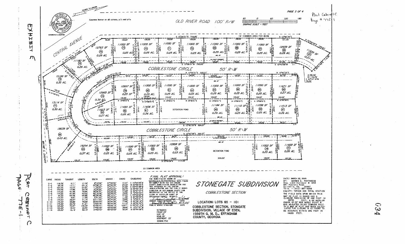
S TONECA 2E SUBDIVISION
CO399Z ES TONE SECT/ON
LOCATION: LOTS 65 - 101
COBBLESTONE SECTION, STONGATE SUBDIVISION, VILLAGE OF EDEN, 1559TH G. M. D., EFFINGHAM COUNTY, GEORGIA
DATE MARCH SS, 0005 BY: WARREN E. POYTHRESS Roe. Lend Surveyor 8 1953 991 HURTer; Rood 55108018, 00. 30467 To I;. - (9I2) 857-3088 EOUIPT: TOPCON 303 TOTAL STATION
THE FIELD DATA UPON WHICH THIS MAP OR PLAT IS BASED HAS U
LOSURE PRECISION OF ONE FOOT IN • 26735 FEET, 6 AN ANGULAR
ERROR OF OS' PER ANGLE POINT B WAS ADJUSTED USING COMPASS RULE. THIS MAP OF PLAT HAD BEEN CALCU -LATED FOR CLOSURE 8 IS FOUND TO BE ACCURATE WITHIN ONE FOOT IN
44035 FEET.
(ZJ
ORG / -
/ -. Concrelo Marker on all corners. Pc's and pro. CL L7 ,?/i/LER P0.4/7 100
PAGE 3 OF 4
.39 P1, Iu...un.. Iu...fl...
Q \c 4 Cpc.'s'e C
i '1'k
00050000SJCt%00000000 .'' _- N 13-06-01 - E 74993' 6 COMMON AREA FOR BERM N I2°46'34"E
' - r- r'' , p//000 5F 'I/ISP I //GX /000 SF p /COO //SFt10W 5F
/2763Sr 0 12459 SF
® I -. cE254C'S8 O.2SAL'. , 0.25 AC. oI - 0.28 AC. a25.4c. 1 a25A.' a25A'. a2sAc. a294c
111805F0\9 - ItI --------
$ Iw_ _S a s COBBLESTONE CIRCLE 50' P \ IV
N 13'06'0IE 668.21 N I2M0'36'E
"
SF /<
0.3540.
/0957SFj //cCOSF0 . 111300SF I. 11000SF 4. //000 SF //000 5F 00] 11671 SF%
/2985 SF : 0 • ® €) 001 8
. 0.25 SF ' 025 AC. ' 0.25 AC. 0.25 AC. 0.25 AC. 4 - 0.25 AC. I I 0.25 AC. EI 0.27 AC.
III . I II 100.00' 103.00' 00,00' 100,00' 109,09' I 100.00' 0'171 FMW
/3/14 SF / 1./ / a38Jc Ni3000I .ETO,UBI ] 6 13'ONOVE N I305'0IE ]N l3O6'OI'E I3'06'OVE
146'0 5F /l4O6SFi: L
11184 SF ////0SF,- 1038 _9F :: 11513SF 030.4C '1 r -- /I63SF
0 DETENTION POND
Al 0
'III U 0.2640. '0; 0.26AC. 0.26AC. O25AC. 0.25.40. 02640.
I
H -1
A. 80.46 9.79'
40'14'1 8"W'
\ I S I2M0'3BW 864.57' ------.-
/8639 SF\ COBBLESTONE C/RCLE 50' P \ M/
43 AC
N 12°40'38E 864.37"
--u- -- ----T--- 69
16254SF j. 10998 5F iioocsr :I //469SF
0 0.25 AC.
@ E'I .. 0 i a25A. 0.254C
T i DETENTION POND 0
_ / _ O_L
0.25 AC
_r L. I 50 C0kV,ION AREA
0
4' ti ' 2
()
FINAL RI .47 APPROVAL: CURVE 800125 TANGENT LENGTH DELTA DEGREE CHORD CH.BEARINS THE SUBDISION KNOWN AG
2Y9MAAETEIV
GELEO0HA$ FOUND C-I 119.79' 8.71' 17.39' 8° 19'04' 4749'55 17.37' 0 I6°30'05W To Dow#LN i6W'7i6 6FF INOHAM
C-2 69.79' 10.7 1' 03.14' 20038 I3 8206'O9 25.00' N 22'59'45"E COUNTY 50901015 ION REGULATION AND
C-3 20.75' 12.23' 24.37' 1103357 0 4702701 • 24.33' S 06'53'39W WAS APPROVED BY THE ZONING
C-4 170.75 17.96' 35,79' 12 00'40' 33°33'20 30.73' N 06'40'1 8E ADMINISTRATOR AND THE PUBLIC NOOKS
C-S 114.22' 41.06' 79,84' 38°52'57 5000943 77.29' N 3027'07"E DIRECTOR OF EFF I 606AM COUNTY FOR THE RECORDING IN THE OFFICE 01'
C-6 114.20' 41,09' 80.30' 401 1 6'4B 5009'43 78.66' N 72-22100'-E
C-7 64.22' 09,38' 95,85' 85°30'48 8912'67 87,20' 0 05°26'02W CLERK OF SUPERIOR COURT OF
C-B 114,22' 0.67' 11.33' 5'4I'03 50'09'43 11.33' $ 8439'O0E
C-B 175.00' 36.07' 71.14' 23° I7'25 32°44'28 70.66' S 10'09'5I'E L. C-b 75.00' 39.96' 78.58' 25°43'40 30°44'26 77.92' 5 4D'39'I8E ZOM O YE
C-Il C-IS
175.00' 120.00'
30.70' TSR?'
41,21' 136.38'
I3°29'36 620304 1
32°44'26 45Th0' I 2
41.12' 129.71'
S 26'OO'4OE N 50'33'13'W PUBLIC WORKS DIRE DATE
C-13 20.00' 9.43' 38,55' 17°40'09 45°50'09 38.40' N I0'27'47'W
C-14 105.00' 16.16' 32.13' 14M3'43 45'50'09 32.04' N O5'44'09"E SETBACKS: FRONT 25' RIDE IS' REAR 25' SIDEFRONT 25' ZONING POD

1
'-4 -1
01
p
10'-0ov'ln)rilrEF I NGHAM COUNTY SUBDIVISION REGULATION AND
/ 5IAT ' WAS APPROVED 01 'THE 208190
. -'' ADMINISTRATOR AND THE PUBLIC WORKS DIRECTOR OF EFFINSHAM COUNTY FOR RECORDING IN THE OFFICE OF THE
l CLERK OF SUPERIOR COURT OF
PO OEHM}RAUN1. GEORGIA.
OTUNINS " SATE
PUBLIC WORKS DIRECTOR DATE
-- - - - - -
--60 - 20 180 at_i
I I I C041/IONAREA GRAPHIC SCALE - FEET
N 12'40'38E 990.78'
L,11r ; r0&0 '°°°
'°
'°° 100.10 /
//C00 5F ,,ws,c i/ocsFi
3ç e ® + 2595/ SF 030 sr
a25Ac. a25A. 0.25 Ac. 0.25 C.
0.25Ac. 0.25 AC. ° S 0.294C.
o
oos 7 /'
SALLAS7sTCNE c/RaE 50' R' W
, ,
_-q-ro:T rw.m rc.~ -: rr- g
'E /688 7 5F j 7 /78/
I- _I- 4 SF " 11' ' I -I,, " - /3264 SF /
"-1 4 1 0 r1IoIi /5/39 SF o,I /4/0/ SFL.
a39AC. /5239SF4Is /5/44SF11 1'm ' 0.41 AC /
I , e "-" "i
;0 O3OAC I 20463 SP /
•1/T'W I3L L\ 0.35 AC O.J4AC 0.3SAC. 0.32 AC. ,/
lOVE til l 0.4FAL'. // '/ /
I l 00.01 4 902
) /340057
oTE" _ N1025O3.T :'1 N
/808057 -'V- \s. 0.3/ AC. 1I\
/65/8 SF
-
/8662 SF 042 AC ' - ,/_ VL 0I I
809" 27 I tS 2/377 SF ' "V - ,. c' - ,' /8220 SF IA ' k~q
I 043AC H1-' Q
3,, 4 0.44AC '"' O.49AC. '°I 0.42AC. / DATE: MARCEI22,2s I BY: WARREN K.: P0 I /8/49 SF
- 'YTHRESS
'I. . 1 T.s'P i is. 5 953
Sy Ivan la ~ 'Go. 30467 a42 AC.19902 5F
'
Ol 51510 d 'THE FIELD DATA UPON WHICH THIS
2 00 a46 AC.
\'R PLAT IS RE PRECISION OF ONE F007 IN
c- 13
\' BASED HAS A
- ERROR OF OG PER ANGLE POINT 8 ..F-Ie WAS ADJUSTED USING COMPASS RULE .
Al 46' C - - asa Ac. " )' os6üTs
28437SF - , W /6930SF-% \,".. BE ACCURATE WITHIN ONE FOOT IN27473 FEET.
------- --4---_---\ --- L 0.65 AC. -ft -' 0.39 AC. '
22/77 SF SI 19631 57 A'\_ , CURVE RADIUS TANGENT LENGTH DELTA DEGREE
,.,I /7889 5F 15.00' 23,56' 90'00'I0' 361-58:1 98:
0.5/ AL f' 2403/ SF ' " cc g 70'
6 :: 0.45 AC. s H
c--4 112.17 40.85' 78.53' 40'06'43' 51'04'39"
0.4/ AC. CS 08.22' 25.77' 30.80' 26'47'2I' 52'36'46' I I ,.., 'ç C-S 108.21' 39.41 73.82' 39'00'O9 5256'46'
C-7 08.22' 07.60' 54.04' 28'36'42' 32'56'46' C-H 5821' 60.96' 98,00' 84'29'I I' 98'25'18'
89,35' ., g - . , LD C-H 88.55' 70.25' 118.96' 76'36'U3' 64'24'59' C10 138.95' 28.94' 53.02' 2I'09'40' 41'14'09'
- 58.77. C-Il 39.95' 42.93' 83.28' 34'2O'24' 41'14'S9" S - C-ID 138,95' 24,50' 49.28 O0'I9'2 ' 0' 4II4'09
W
04-R8' C-IS 267.35' 50.06' 08.39' 23'16'24' 2I'25'S3' C - 14 267.35' 54,00' 67.93' I4'29'SR' 2I'2553'
FINAL PLAT APPROVAL: .81 36 . d CERTIFICATE OF ACCl/RAC)' C- IS 317.35' 43.84' 87,32 I5'45'54' I8°03'IT'
THE SUSGIVIUION KNOWN AS 5'IST.4'/,v48 - A....,, IP' C-IS 517.35' 51,37' 101.87' 18'23'29' I903'IY'
.-"".'.. STOEJEGATE RALLASTGTONE #85 SEEN FOUND LEUo,c,EsT I HERESY CERTIFY THAT THIS FLAT C IT $1735 500 1000 14620 180317 IS A IRUL, CORRECT, 861) ACCURATE SURVEY AS REOU I RED ST THE EFF I NGHAM
"' C'IR
'.'.'iI GAUl 513.76' SH,20' 99.30' 5TONLG.4 7" S1h2/V/S/ON COUNTY SUBDIVISION REGULATIONS CVEO 593.76' 42.40' 04.80'
9ALLASTSTO/VE' SECT/OAf AND WAS PREPARED FROM AR ACTUAL C -21 583.76' 61.38' 12229' SURVEY OP THE PROPERTT MADE UNDER MY C22 317.35' 3.00' IO.w
LOCATION: LOTS 102 134 SUPERVISION, AND THAT MONUMENTS SHOWN HAVE SEEN SETBACKS: LOCATED AND PLACED TO THE SPECIFICATIONS
BALLASTSTONE SECTION, VILLAGE SET FORTH IN SAID REGULATIONS. FRONT OS'
OF EDEN, 1559TH G. M. D., SIDE IS' REAR 25'
EFFINGHAM COUNTY, GEORGIA SIDE FRONT 25'
WARREN E. POT'DIfTEDS RLS 1953 ZONING - PUS
WETLANDS SHOWN ON THIS PLAN ARE UNDER THE JURISDICTION OF THE AS ARMYCORPS OF ENGINEERS. LOT OWNERS MAY RE SUBJECT To PENALTY BY LAW FOR DISTURBANCE TO THESE WETLAND AREAS WITHOUT PROPER AUTHORIZAT ION.
137OI' II'0908' 836' to, I0094
122539' 0'094 140zO' 18,05 , 17.
CHORD CH.OEARIHG
21.21' S 07'47'16'W 2121' S 82'I2'44'E 42.64 8 32'44'03'E 76.84' 6 32'44'00'W 50.14' S 00'43'02"E 72.40' S 33'59'I7'E 53.48' 67'OO'ID'E 05,49' N 34'35'S8'W
110.29' SR5D'ID'W
50.89' 87'13'07'E
82,04' 59'04'35'E 49,02' N 31'44'43'E 57.02' S 09'36 15I'W 67,45' S 08'56'I0'E 97.04 N 11-53'46'E
101.43' N E5'IO'DD'W 10.00' N ID'I6'50W 20,00' .5 3O'SO'SD'E
S 19159 ,30, E 88.57' N 20'E9'05'W 02.04' N 3059'59'W 10.00' N 20'40'53'E
A)
CA
coaFLESrONE
P4054 074

LAKE r'T 036
EX }jiJi r c
STATE OF GEORGIA
COUNTY OF EFFINGHAM
This declaration of protective covenants for the property hereinafter described made and published this .S day of August, 2002 by the undersigned.
W1TNESSESSETH, WHEREAS THE UNDERSIGNED ARE OWNERS OR ADJOINING OWNERS OF A LAKE LOCATED OFF Old River Road near the Eden Community in Effingham County, Georgia, presently known as Lake Jean according to a plat of survey of Mandalay Subdivision made by Vincent Heimly, Ga. Registered Land Surveyor No. 1882, dated June 29, 1975, and recorded in the Office of the Clerk of Superior Court of Effingham County, Georgia, in Map Book 5, pages 226-227, and
WHEREAS, there exists at the present time owners of property whose property lines either reaches the high water mark of Lake Jean or whose property lines extend into Lake Jean, and
WHEREAS, it is understood that certain lands that include Lake Jean are to be developed into a subdivision in which a homeowner's association will be formed, and
WHEREAS, all parties to this instrument wish to preserve the beauty and integrity of Lake Jean,
Therefore, we agree to the following;
1.) All parties agree to enter and/or exit Lake Jean only from or onto the property that they own, unless they have written permission from another property owner, and
2.) All parties agree that only property owners who are party to this agreement and future grantees of their property may be allowed to put boats into the lake. This does not apply to the Homeowners association or it's members, and
3.) All parties agree not to use gasoline powered motors on boats or jet skis or similar type devices, and
4.) Homeowners association covenants are to forbid the use of any flotation device within the lake, and
5.) Homeowners association covenants are to forbid swimming within the lake, and 6.) All parties agree to fish only from their property when fishing from the bank, (
this is to keep persons from entering the backyards of property owners and inhibiting their privacy.), and
7.) Homeowner's association covenants will state that all fishing done from Lake Jean will be strictly for recreation and not as a food source. For this reason, all fishing should be done on a "catch and release" program, and
8.) It is un4erstood that all owners of property which lie adjacent to Lake Jean will be given the opportunity to join this association with all rights, privileges and obligations as though a homeowner in the subdivision to be formed, understanding that if they become a member they will not give up any rights previously granted above.
This agreement shall be binding upon the property owners of record of this date as well as all future property grantees and homeowner's association which is to be formed to include portions of Lake Jean. This instrument shall be made a part of public record and shall follow the land from this date forward, as evidence by our signatures below.
((')

037
Enforcement shall be by proceedings at law or in equity against any person or persons violating or attempting to violate any of the above covenants, agreements to restrain violation and to recover damages.
In witness whereof the undersigned have hereunto set their hands, affixed their • seals and delivered these presents as of the date and year first a vyritten.
Signed sealed and delivered in the presence o F ()A
Unofficial Witness
)4ry Public J01414 B. OF10MIN 7 / Wcvterj Public, Chatham County GA
• My Comnision Expire. QctQber , 2Qi.
• Signed sealed and delivered the presence o
Unofficial Witness y
________
'roperty Owner 'roperty Owner's Address:. 102 ewe, 1,7;?4N0/e
6i JJ"2
E,cS46e, 7'e
4'm6'' 7JEVEo,4',,ciyr 12vc .
Property Owner Property Owner's Address: A02 E4zlV
67 ,4wZ,0 31312-
Property Owner Property Owner's
io64i6,~A 3'/3 —.
Na,jr Public
7 / rnuLsor gxre Qtober 7, 2OQ
Signed sealed and delivered the presence o:
Unofficial Witness
Public J'iotary I Crnty GA y.nioa xpire October 1, 2tl
Signed sealed and delivered in the presence of:
Unofficial Witness lij
Public •
JOHN B. CROflN
• iolaty Public, Chatharo County, GA My Cornmiaaion Expires October 7, 2005t
Signed sealed and delivered in the presence oft
I . _D U
~_A C', 45,
U~ I,-
LQ Property Owner
çoperty Owner's Addre ss: '\ b\ ç2
Property Owner Property Owner's Address:
f2A , c 8Q-7
Unofficial Witnej- L/ /
bTfry Public B.
Notary Pubij, Chat ha cc Couniy, GA M Conm,j Expitu. 0Ctobt 7, 2OO (z)

Signed sealed and delivered in the presence of:
E . Unofficial Witness
No.tØry Public JOHN B. CRONLNi
// N)lry Public, Chalhan rounf G/ // anon Lpre
Signed sealed and delivered in the presence of:
038
Signed sealed and delivered in the presence of:
't Unofficial Witness
Property Owner Property Owner's Addres:I'/ ?
7
Public JOHN Ci1UN Wary Public, Chatham, Coup GA
My Crmrnisioft Lxpir Qcibt 7g(
Property Owner ç 3 Pr9prty Owner's Address:
' / 2
.ii1cLL4 Property Owner Propty wner s Mdress:___-
cLQ )
5
Public JOHN B, CRONlN Ncthry Public, Chatham Coumbf, GA
My Cmunision E,cpi Ocoh 7 2G
Signed sealed and delivered in the presence of:
& &L
U cialWitne '
J 2,L)WQ-' Owner
Adress: O /
Public . lc
. Count GA Expixjo.Nr 7,
Signed sealed and' delivered in the presence of: Property Owner
Property Owner's Address:_____________
Unofficial Witness
Notary Public

039
EXHIBIT H LEASE
This agreement, made this 20th day of April, 2005 between AMBY
DEVELOPMENT, INC., a Georgia Corporation, having its principal office in Effingham
County, Georgia (hereinafter "Lessor") and STONEGATE AMENITIES, INC., a
Georgia Non-Profit Corporation having its principal office in Effingham County, Georgia
(hereinafter "Lessee")
Lessor does hereby grant, demise and let, and Lessee does hereby take that parcel of
land that is located adjacent to and to the East of Lots 43 through 51, inclusive, and to the
South of Lots 52, 53 and 64, and extends up to and behind lots 60 to 64, inclusive, and is
located to the North of the Club House and Amenities Area, all of the Pebblestone
Section of Stonegate Subdivision. Such property is also known as that tract which now
or will have or is reserved for the drain field area of the Land Application Sewage System
which will service Stonegate Subdivision and has specifically been excluded from the
Common Area which has been or is to be conveyed to the Lessor in any other manner
than this Lease, from the 201h day of April, at the rent or sum of One Dollar ($1.00) per
month, plus other consideration outlined herein.
It is further agreed by and between the parties that the Lessee shall be able to use the
property for Recreation purposes, inclusive of Soft Ball field and soccer field, but not
limited thereto. It is understood that no clay shall be used and that all areas must be
maintained in grass for the purpose of the drain field. All mowing and maintenance costs
shall be paid by the Lessee. Softball backstops and similar fencing may be installed at
the expense of the Lessee and after consultation with the Lessor to determine any location
of underground piping. No other digging or construction of any kind will be permitted
upon the property.
It is further agreed by and between the parties that the Lessee shall maintain proper
insurance to cover all appurtenances located above the ground level of this property and
to maintain proper liability insurance to cover any and all activities conducted thereon.
It is further agreed by and between the parties that the Lessee and its Members shall at
all times hold the Lessor harmless for any and all matters, circumstances, accidents,
situations or damages of any kind which may arise on this property.
It is further agreed by and between the parties that the Lessee shall take all steps
necessary to protect the underground piping, inclusive but not limited to the tubing,
valves, wiring, and controls that shall now or hereafter exists.
It is further agreed by and between the parties that the Lessor shall at all times have
access to this property and be able to use it for the purpose of the drain field for the Land
Application Sewer System and any expansion thereof.
It is further agreed by and between the parties that the lease herein provided has been
executed this 201h day of April, 2005, and shall run with the land on a month to month
basis for a 20 year period and shall be extended or terminated under the same terms and

G40 conditions of the General Declaration of Covenants and Restrictions for Stonegate
Subdivision for that Declaration as contained therein, with the following exceptions:
(a) It is agreed that if in the sole opinion of the Lessor or his assigns that the
property is not being maintained, used for the purpose of, or cared for as outlined in this
Lease, the Lease shall terminate and the Lessee shall lose all rights to the use of the land
and shall abandon all appurtenances and structures thereon; or
(b) At any time during the lease it is determined by a two-thirds (2/3) vote of the
Association Members that they wish to cancel this lease, for any reason, that cancellation
will be granted by Lessor and that Lessee shall lose all rights to the use of the land and
shall abandon all appurtenances and structures thereon
IN WITNESS WHEREOF, the parties hereto do set their hands and seals.
Witness Wendall A. Kessler, President
AMBY DEVELOPMENT, INC.
Witness Wendall A. Kessler, Registered Agent
STONEGATE AMENITIES, INC.
H

041
EXHIBIT I LEASE
This agreement, made this 201h day of April, 2005 between AMBY DEVELOPMENT,
INC., a Georgia Corporation, having its principal office in Effingham County, Georgia
(hereinafter "Lessor") and STONEGATE AMENITIES, INC., a Georgia Non-Profit
Corporation having its principal office in Effingham County, Georgia (hereinafter
"Lessee")
Lessor does hereby grant, demise and let, and Lessee does hereby take that parcel of
land which lies to the North of the Service Road shown on the Subdivision Plat for
Stonegate Subdivision and recorded and recorded in the Office of the Clerk of the
Superior Court of Effingham County, Georgia in Plat Cabinet C, Page 77C-1, and being
the part of the Eighty-Six and Sixty Five Hundredths (86.65) acres, more or less, from
which the Subdivision was created, with such (86.65) acres tract being more particularly
described in Exhibit "A" attached to the General Declaration of Covenants and
Restrictions for Stonegate Subdivision and as Parcel 1 on a plat of said lands as more
particularly described in Exhibit "B" of said Declaration. Said property has specifically
been excluded from the Common Area which has been or is to be conveyed to the Lessor
in any other manner than this Lease, from the 20 1h day of April, at the rent or sum of One
Dollar ($1.00) per month, plus other consideration outlined herein.
It is further agreed by and between the parties that the Lessee shall be able to use the
property for Recreation purposes, inclusive of walking trails, picnics, fishing, camping,
and other general recreation. All mowing and maintenance costs shall be paid by the
Lessee. No construction of any kind will be permitted upon the property without the
permission of the Lessor.
It is further agreed by and between the parties that the Lessee shall maintain proper
insurance to cover all structures and appurtenances that it may own, if they wish it to be
insured, and to maintain proper liability insurance to cover any and all activities
conducted thereon by Lessee.
It is further agreed by and between the parties that the Lessee and its Members shall at
all times hold the Lessor harmless for any and all matters, circumstances, accidents,
situations or damages of any kind which may arise on this property.
It is further agreed by and between the parties that the Lessor shall at all times have
access to this property and be able to use it for his pleasure at any time, and that Lessor
may allow groups or individuals of his choosing to use this property at any time. It is
specifically noted that Lessee shall not have access to any structure which may exist now
or later that is or was erected by the Lessor, without the written consent of the Lessor.
It is further agreed by and between the parties that the terms and conditions of the
Lake Agreement which is more particularly described in Exhibit "G" which is attached to
and by reference made a part of the General Declaration of Covenants and Restrictions
for Stonegate Subdivision must be abided to at all times while using this area.

042
It is further agreed by and between the parties that the lease herein provided has been
executed this 20th day of April, 2005, and shall run with the land on a month to month
basis for a 20 year period and shall be extended or terminated under the same terms and
conditions of the General Declaration of Covenants and Restrictions for Stonegate
Subdivision for that Declaration as contained therein, with the following exceptions:
(a)It is agreed that if in the sole opinion of the Lessor or his assigns that the
property is not being maintained, used for the purpose of, or cared for as outlined in this
Lease, the Lease shall terminate and the Lessee shall lose all rights to the use of the land
and shall abandon all appurtenances and structures thereon; or
(b)At any time during the lease it is determined by a two-thirds (2/3) vote of the
Association Members that they wish to cancel this lease, for any reason, that cancellation
will be granted by Lessor and that Lessee shall lose all rights to the use of the land and
shall abandon all appurtenances and structures thereon
IN WITNESS WHEREOF, the parties hereto do set their hands and seals.
Witness Wendall A. Kessler, President
AMBY DEVELOPMENT, INC.
Witness I) Wendall A. Kessler, Registered Agent
STONEGATE AMENITIES, INC.
Hr L (2

2 ..
%OTAF\
1J131 , j
II
Signed, sealed and delivered in , 5ce
Offl'ial Witness - Not ry Date notarized: 8-26-02
043
FACE NC::
02 AU 28 1 8: 52
ELILBEH •iUREY CLERK EC.CS.C,
4113
ESt1LET
RETURN TO: Ethngharn County Georgia
REDDICK & EXLEY Real Estate Transter Tax
ATTORNEYS AT LAW P. 0. BOX 385 SPRINGFIELD, GA 31329
COUNTY OF EFFINGHAM STATE OF GEORGIA Clerk of Superior Court
THIS INDENTURE, Made the 26th day of August, 2002, between LESTER R. SHEAROUSE of the FIRST PART, and AMBY DEVELOPMENT, INC. of the SECOND PART,
WITNESSETH: FIRST PARTY, for and in consideration of the sum of Ten and no/ 100 ($10.00) Dollars and other valuable considerations, receipt whereof is hereby acknowledged, does hereby grant, bargain, sell and convey unto SECOND PARTY, its successors and assigns, the following described property, to-wit:
ALL that certain tract or parcel of land situate, lying and being in the 1559th G.M. District of Effingham County, Georgia, containing Eighty-Six and Sixty-Five Hundredths (86.65) acres, more or less, and being known and designated as Parcel 1 as shown on the plat thereof hereinafter referred to. Said parcel of land being bounded on the North by lands of W.C. (Billy) Atkins; on the Northeast by Little Ogeechee River; on the East and Southeast by lands of Sustainable Forest Products; on the South by lands of Wayne C. Dasher; on the Southwest by Central Avenue, and on the West by Old River Road, by lands of Cleta H. Burnsed, by lands of Robert Cronin and by lands of Jim Sellers.
ALSO: ALL that certain tract or parcel of land situate, lying and being in the 1559th G.M. District of Effingham County, Georgia, containing Thirteen and Thirty-Two Hundredths (13.32) acres, more or less, and being known and designated as 'Parcel 2 as shown on the plat thereof hereinafter referred to. Said parcel of land being bounded on the Northeast by U.S. Highway 80; on the East by Little Ogeechee River and by lands of Fred Blitch; on the South-Southwest by lands of W. C. (Billy) Atkins; on the West-Southwest by Old River Road, and on the West and Northwest by lands formerly of Shearouse and U.S. Highway 80.
Express reference is hereby made to the plat of said lands made by Warren E. Poythress, R.L.S. #1953, dated August 14, 2002 and recorded in the Office of the Clerk of the Superior Court of Effingham County, Georgia, in Flat Cabinet B, Slide iXL , for better determining the metes and bounds of said lands herein conveyed.
Said plat showing Lake Jean being on a portion of the said lands above described.
Said plat showing the Savannah Electric & Power Company running across said lands.
There shall be no mobile homes located on said property as permanent dwellings.
SUBJECT to restrictive covenants and easements of record. '
TO HAVE AND TO HOLD said property, together with all and singular the rights, members, hereditaments, improvements, easements, and appurtenances thereunto belonging or in any wise appertaining unto SECOND PARTY, its successors and assigns, FOREVER IN FEE SIMPLE with full WARRANTY OF TITLE to said property against the claims of all persons whomsoever.
IN WITNESS WHEREOF, FIRST PARTY has hereunto set his hand and affixed his seal and delivered these presents, the day and year first above written.

0'. " \ N
IV 69. E
NO2o, \ 8o <
6565
\ \\ \ 4 7
\ \'; çt, op
' Conc.MAr.(F)f6.0705
ob
I 'i., . \O CD
oifo Ii
I K dJ
i I K 8 1 JJ .j)r 16 ç
I? -4
I C. /8
'I d
N 305655E " s 86 - - 2 / 185.42 686.85 I t.
8 r- 23 I "°8
N 38°0036E ':: 24
45.00 9' 25
Ii WSELLERS
sr. lb
I I
OBERT CRON/N 'Q°9:'33 :i Conc. 4ilb
19059'4 1 TA H.
17.65 . co At
'
I
V. 110 CV q,
III' ii i4?
C PARCEL / 86.65 ACRES
11 Po
/ J R/WM
I \ \+
M
\ ' t çA
I f R'i
jr
! ' V
'.
co pc .4)
..111.819, -
Al R
co •1 I 114)VE cZ D4s/,-R 7
044
CALLS LITTLE OGEEC//EE RIVER
COURSE BEARING DISTANCE
I S 3I°54'I4E 101.1 2 S 53°59'03E 58.2 3 S I7057'29'E 49.4( 4 S 350 18'08"E 49.5' S S 660 I2'55E 44.2 6 S 440 15'I3'E 99.51 7 $ 65022'36'E 144.2' 8 S 24°30'41E 31.6( 9 S 24°30'4IE 52.7! 0 S 440 I I'I8W t46.41
II S 220 17'31'W 76.11 2 S 22°4042"E 17.81 3 S 50048'IO'E 03.21
14 S 13°48'05E 118.8! IS S 64047'0I'W 84.6 6 S 3004446"W 85.4:
17 S 2000 1'32"W 117.11 8 S I.8 055 100"W 105.6
19 S I5°16'07"W 56.5' 20 S 14° 19'02"W 146.11 21 S 10009 , 2 1 W 40.24 22 S 5403502'W 153.9' 23 5 15 008'1 3"W 106.1 , 24 SOI°30'23'W 113.9' 25 S I0°12'OO"E 64.41 26 S 0704933"W 63.2' 27 S 36049'22"E 122.6: 28 S 55041'I7E 59.5 29 N 85003'37"E 44.54 30 S 74° 15'47'E 140.41 31 S 3800 1'58'E 121.2: 32 S 82° 19'41'E 86.54 33 S 74°3424'E 130.a 34 $ 220 16'I4E 62.8 35 S 70030'59"E 59.0 36 S I2047'06E 44.0 37 S 60°37'46"E 109.0 38 S 32°33'I I'E 62.1' 39 S 41°27'01"E 201.0 40 S 73°25'58"E 77.3; 41 S 44°55'53E 167. 42 S 08058'56"W 58.6 43 5 2800806'E 80.5
EtT
F1'
DATE: AUGUST 14, 20 BY: WARREN E. P

r1
H w H
•2
PAGE / 074
YIC- - I
\
) F
(IA
0 / -.
7150 5F
alsAC. NJNb08'0IW 10.00 I
• 'N'ON'oIE 110.00' 'OS
.I
7150 SF 8,
- 0./SAC. 1 10-01 --4 ,
3. 71,50 5F
a 0./6A0.
N'OIw 0.00' zi 76ON'DIE 110.00' ('1
7150 SF
0./SAC. NJ'NO8'OIW 110.00' I
• : S 7B 108'SVE 110.00'
I
7150 SF 1
0./SAC.
s .rar_HI
1 - '1 '8i - 850SF I FINAL PL4TAPPR0VAL. I aloAc.
L jii ai.
'° 0./5Ac. I
I 7I50SF 7150 SF
SIQkrsjHAs BEEN FOUND
------- —. I - 110,00 1 115.00 _J_ I J, I p I . ("s p 53J . TO COMPLY WITH THE EFFINSHAM
• . . I I p — ..j - 0.19 AC. W' COUNTY SUBDIVISION REGULATION AND 0700801 E • I s 7608'01"E ,,, S T6'OB'OI"E I I 01 0 I 110.00' — - WAS APPROVED BY THE ZONINO
71,50 SF I - - I I. '- 0./SAC- a ADMINISTRATOR AND THE PUBLIC WORKS I 7/ 0 SF , I 0,, - I 7ND8'OIE I'
- 8 DIRECTOR OF EFFINSHAM COUNTY FOR
S © 181 I 0 I I 7150 SF I CLERK SF5 ERRU OF THE
AT Of I
I&" L '
a,' 1
I Q 8 N76ON'OISD/DO EFFIRAHAMY.EORDIA.
,,// H----;— --W 0./S AC. DATE: MARCH SD, 2005
Z0_AD TJ 'DAT'E
BY: WARREN E. POYIHRESS PUBLIC WORKS DIREC*H DATE N 76°08'0IW 110.00 RUg. LOTA SUrVeYOr 5 1953
001 hunterS ROSS Sylvoolo, Go. 30487
- Tele. - (RIS) 657-3288 EOUIPT: TOPCON 303 TOTAL STATION
SETBACKS: THE FIELD DATA UPON WHICH THIS FRONT OS' MAP OR PLAT IS BASED HAS A SIDE 75' CLOSURE PRECISION OF ONE FOOT. IN REAR 25' 26732 FEET, 8 AN ANGULAR SIDE FRONT 2.5' ERROR OF D6 PER ANGLE POINT & ZONING PAD WAS ADJUSTED USING COMPASS ROLE.
THIS MAP OF PLAY HAS BEEN CALCU- LATED FOR CLOSURE 8 IS FOUND TO BE ACCURATE WITHIN ORE POST IN
- 4SF FEET.
ORO
No, 953 Eop DO
o F. po'I
CEPTIF/CATE OF 00///ERS/IIP S 250/CA T/0N. IT IS HEREBY CERTIFIED THAT I AR THE OWNER OF THE PROPERTY SHOWN B DESCRIBED HEREON AND THAT I HEREBY DEDICATE ALL ALLEYS,
_-STREETS AND EASEMENTS TO PUBLIC OR PRIVATE USE AS NOTED.
a
STONEGATE SS89101S/ON PEBBLES TONE SECT/ON
LOCATED IN THE 1559TH G. M. D. 8 VILLAGE OF EDEN, EFFINGHAM COUNTY, GEORGIA
- 50 0 50 /00
CONCRETE MARKERS ON ALL CORNERS PCS AND P10 150
SilLilY EASEMENT ON OUTFALL PIPES TO BE
\\\
p—' - ._-- 11111111111 I I I IS CENTERED ON CENTER LINE ACTUAL PIPE/iOCATION. _---' n5MENT 0 \ GRAPHIC SCALE - FEET -
COMMON AREA ENDS NORTHERN BOUNDARY ,.__-$ ELECTRIC "WEe LINE - -- \\ - - -
- - -- po WETLANDS SAO ON THIS PLAN ARE UNDER JURISDICTION OF THE US ARMY CORPS OF ENGINEERS LOT OWNERS MAY BE SUBJECT TO PENALTY BYLAWFOR DI TURBAN E
THE I /
OF SERVICE ROAD I, / SAVANn __-- \ ..,J 0' I
_._ / // "i -' -
THESE WETLAND NREASWITHOUTPROPE_- ' AUTHORIZATION. / ___'__ I" 8/
VEDST IA---- ----
BAAII5E_
OI7°b8'OIE 120.00' 0.18 AC.
- / S •_--
p i 0 N 7NO8'OIW DON
I 75.97SF CCIMMOIV AREA
S 76'08'01"E 120 00' ,K Al 8164 SF op I ,I- p
I t__ b0l h! / /I iI - 08 N 78
0 TN 0801 E ,.0 o 01 W I25,N 8078 5F
7/50 SF' S 76O8'OVED.6
° 0./9ACRES
8 0 I - 8164 5F 0'
I 0 a/sAc.
I t----F--f L1I0051j r76oaoLE o4_NTNN'256
I , 7150 SF I p 7/50 SF
r'- 055 S 7N'O8'OI:-125 t
0 I I.: 9250 SF 8164 5F
0 a/SAC I o00.f 0/SAC
8 '
S7GOEOIE PIO.OG I O.00' p 0.1940. 1 0.194C 'ai I S 76-0a'01 *E I I .. 712.5. S 76 0801 E J AT , N , NO _.2.20_.._, N 76'08'01"W 125.60'0
I ' 7150 SF I 8250 SF 7150 SF , S NO8'OI E 110.00'
7,L50 SF & I. S .9164 9F
I , 0./6, .4c. ,0 ''8, a/9A. O ,54C :j :
4 0. 164C, I I 7150 SF 0.l5.4C. I '8 8 I L._L I UOS0' 0./9
S 4c. - 02040.
I W08'0I E I L__L5'/WO'040' I - - - - — - -
STNO8'0I E 10 S 7SS80rE -----2560 '8
7150 SF II 71.60 SF , 7150 5F .-
- 0/SAC 8ii ç ' a/64C. I3RAVEL WAY I , 110CC)' I I
— — -- — - -I . - -- - —. — - _L °— -I- -i--s S 76'08'01'E 240.00' S 7608'0IE I S 7608'0IE S 7ND8'0IE I I
I .
7150 5F I'I c 71-60 5F , 7150 SF I r ----- I I ng• 'U II (\ IQ 132
(t
....J r1 '1

O 65.00 65.00
sJ g 7/505 7150 4 7150 S, 7150 S, 7150 Si
© " © © © 4: 0./6A: 0. ,4C.= = 0./64: O./64&
PP Pp 8 pp PP 87M51 PP
r8. r
- aI6AACI= -
- 10' 010/77 04SF/lEN - -
00.03 65.00' 65.00' 65.00' 85.107
P46E20F4
455.00'
60,03' 65.00' 65.00' BROS I'l ---- (N-
C- H
IN
65.00
-dd
1 ()
-J
OT I-i
/ /
GTE
IS
SETBACKS: FRONT - 25 SIDE - 7.5
I : -
REAR OS SIDE FRONT 0.5
5 7150 AdS 100 7/S.
ZONING PUS I
EA
N I3'5I'59"E 215.00 ai
2 .__TDNC.__. _s.00.__ _J ,, 5QO_
al 8. 8250 SF -d 7/50 SFc5 6 8250 SF
.00001 M,ME.IO,EI S
CO,SIMON AREA
/ N 13'51 '59" E 185.00'
O.194C.P I 8.
.0001
P 0./SAC 0 8.
65.00
0.I9 AC.I 8
75.00
/ 0009 65.00 N I3'5I'59E N I3'5I'59"E 1 65.00 NO.00 N 13'5759"E/l Z
7I5OS/ 7I50S/ 3 715o S, 70S,00
7, OS1 8250SF
a a a a © a/SAC. 0./S .4C.A 0.16 4C. r; 0.1540.
85,00' f0'U1/uI1I'045&4l&V
65.00' -
''
- - I
ENTRANCE
>& I
cn
1 -3'
O-* \
S 15S100W
SANDSTONE DRIVE
r n
fl IO, I .SS .W 70.6 I'
50' R\H'
N I3'5I'59E 1000 ' -
75.00' -.
60.00 - S Z
525OSF. 2.
81® ® O.I9AC.83
S 13'5I109"W -
I 75.00 S13'SI'5S'WJ,9
65.00' T' I S'
P I P 8 825OSF8E 8
®
5'
S I3'5I'S9'W 40.00
PESSLES TONE DRIkE DO ROIl'
n~L/6o. C.'T
3'5I ' S9E ________ ___________ 7--65 00' 4 585.00'
-
j - H 7150 SF1 7/50 SF,'I 7150 SFI 7/50 SF2(I_ 7150 SFI - 7/50 S/S I 7150
® ® _l= ® ®
A a/6AC. O./64C." a,'o,c. 0./SAC.' 0./6AC 0./SAC.oA 0/6Ac0T. 8
_ 65.00' 65.QO'_ 05,00' - 65,50'
05.00',, 65,00'_
S I3'5I'59W 585.00
STONEOA iF SUBDIVISION FINAL PL AT APPROVAL: DATE MARCH 00, 2005 THE SUBDIVISION KNOWN AS BY: WARREN E. POYTHRESS
PEBBL ES TONE SECTION ST0NSAJQNLE_Q0Jj6AS BEEN FOUND Re?, LOON Our veyor 5 853 TOCO65LY WITH THE EFP 1630DM 99 Hunter, Road COUNTY SUBDIVISION REGULATION AND Sylvoslo, Go. 30497 WAS APPROVED BY THE ZONING Tel,, - (912) 857-3288
LOCATED IN THE VILLAGE OF EDEN ADMINISTRATOR AND THE PUBLIC WOWS TORCON 303 TOTAL STATION
EQUIPT:DIRECTOR OF EFFINSHAM COUNTY FOR
1559TH G. M. D., EFFINGHAM COUNTY RECORDING IN THE OFFICE OF THE THE FIELD DATA UPON WI-I ICH THIS CLERK OF SUPERIOR COURT OF MAP OR FLAT IS BASED HAS A
GEORGIA :E:~~~E .OROIA. CLOSURE PRECISION OF ONE FOOT IN T0~ IT IS HEREBY CERTIFIED THAT I AM THE OWNER 26732 FEET, 8 AN ANGULAR
OF THE PROPERTY SHOWN 8 DESCRIBED HEREON 2/
'
'DATE ERROR OF 06" PER ANGLE POINT 8 -=0'- 4---oS WAS ADJUSTED USING COMPASS RULE
UB . AND 'THAT I HEREBY DEDICATE ALL ALLEYS,
IC WORKS DIRECTR DATE THIS MAP OF FLAT HAS BEEN CALCU- STREETS AND EASEMENTS To P LI C O R PRIVATE FL) USE AS AND LATED FOR CLOSURE B IS FOUND TO
BE ACCURATE WITHIN ONE FOOT IN IA/P FEET.
06508 SATE

1
'-I
H
I
- MGE3OFI
-- -
Concrete Marker on all cornero, P06 and pro. 50 0 50 120 180 3 OLD RIVER RO4D /00'R71/1/ IIIIHIIII I
Al
2006 2, - CR4PMC SCALE - FEET
N 13'06'01'E 749.83' 16' COMMON AREA FOR BERM N 12 -46'34"E
12459 SF 12763 SF
c 02940 0.25 AG 0.2540. , 225 AC. A 1 - a254c'. 0.25 14 0- • a29 AC.
- -- i:S 13-06 10["W 700
, 0.26 40. C0891-E57 ONE C/RCLE 50' R\W/
-- p.32.12 N 13'06'01'E 669.21 N IDMO38E
' S 40
L 'V ---
10957 SF: I/0C0SFL18 11000SF ii000s,°- //000 S." //000 SF _ 11000SF 11671 SF
42955SF 0 0
/ / / ,, I 0.25 SF ni
0.25 AC. 0.554C. 0.2540. A 0.2540. A 0.2540. 0I I 0.2540. 8 0.2740. I
13114 SF
__00D.'_ 10000' 10000' . I I
100.00,
/ / /
038
-]
4
r 4o f 69U" -. /14805F 1 - //4055F - i 11184t 1i1,'o5,o- 11038SF I/535
t.rk 0 DETENTION POND ;ji2 0 0 1l 0 II'III 2- 0.2640. I 0.2640. - 0.2640. 0.2540. .L I 0.254C. A 0.2640.
L.Jl .. (.02 III '
\.\ .oE8L_L_E.c___1__ICo,c5'-----, --son--------I I __
\Tn 'o..,,, I69TH9 12140'38'W
85.27' C-3
I'
1863957" 1 COBOL ES TONE CIRCLE 50 R \ W
N I2°40'38E 864.57' -
'- 0.43 AC. - F - I
I 16254 SF '_ 11000SF _ /(o00sFI' /10(X) SF 10998 5F 11000SF : 1469 5F
0 k 0 8 0 I8 0 0 _L DETENTION POND 0 L 0.37 AC. 0.25 AC. 031 0.25,4C. 0.2540. s 0.2540. 0.2540. i 0.2640. Its
iI I I I
°°°' .
50 COMMON AREA
FINAL PLAT APPROVAL:
Roa C-
TCURVE RADIUS TANGENT LONGS-I DELTA DEGREE CHORD CI-I.8EARING THE 01 VIP ION (60*71 AS 008 DATE: MARCH 22, 2005 BEEN FOUND BY WARNERS E POYTHRESS
AND 56 77A/L',4Tf S/19L7/1'?S' ?Hr03O4:71953: 24.37: 47*27 01
.24.33 06'53'39'W WAS APPROVED BY THE ZONING
6 09 5.00
COUNTY SU V1 ION REGULATION
C4 10:;7 05 17. 96 35.79 1O0040 333300 35.73 N 0640180 ADMINISTRATOR AND THE PUBLIC HONKS - Toe - 19101 807-3088
C-S 14.20 41.06 78.84 38°3057 50°09'43 77.29 N 30'07'07E DIRECTOR OF EFF INGRAM COUNTY FOR . -
C-N I 4.00 41.89 80.30 400 I848 5U0843' 78.66 N 7222OO"E RE CORDING IN THE OFFICE OF THE COSELESTONE SECT/Oil! E0uIPT- TOPCON 303 TOTAL STATION
C-? 64.22 59.39 85,65 80°3048 890 1257 87.00 8 552602W CLERK OF SUPERIOR COURT OF THE FIELD DATA UPON WHICH THIS
C-B 14.22 5.67 I 1.33 5°4I '03 50°O943 II .33 S 8439OD '" ''' EFF.SI1SH)M CQIJN. SEO49 IS. / / MAP OR PLAT 10 BASED HAS A
C-9 175.00' 36.07 71.14' 03' I7'25 32°44'26 70.62 S 7000851 EE / - -...-.-- I ' V/Z'?2t75 CLOSURE PRECISION OF ONE FOOT IN
00 26735 FE, 8 ANANGUILAR ZOhOPIUITRç LOCATION: LOTS 6 - 101 ERROR OF 05' PER
ET ANGLEPOINT 6
0-12 25.00' 75.87' 136.38' 620304 I' 45'5O'I2 129.71 N 00'33' 13I4 PUBLIC WORKS DIREC.T DATE WAS ADJUSTED US I NO COMPASS RULE.
C-13 25.00 9.43 38.55' l7°4O'ON 45°DU'ON' 38.40 N I0°27'47 0 W COBBLESTONE SECTION, STONGATE THIS MAP OF FLAT HAS BEEN CALCU-
C-14 125.00' 16.16 32.13 I4'43'43 45'5O'09 32.04' 0S'44'05"E SETBACKS: SUBDIVISION, LATED FOR CLOSURE 8 IS FOUND TO
FRONT 25' IIJPIJ VILLM'.3 U EDEN, BE ACCURATE WITHIN ONE FOOT IN
SIDE IS' I59TH G. M. D., EFFINGHAM 44035 FEET.
REAR 25' SDEFRONT 25' COUNTY, GEORGIA
- ZONING PUS - - -
1c.
rn
() -J •2
17 1
()
C)

V\c\ Th'r-
ti
coBBLesroNE SECT/ON P46E 4 OF 4
60 0 __ 120 1 80
I I I I I I I I I COMMON 4REA ot 3t9V*
GRAPHIC SCALE - FEET N I24038E _99O.7O
100.00 '
_________
t---
-107-
, -To -oo c J= 1 . -4 I - -I-4
I/COSF I 000SFii2 //OOOSi' //000SFI I 1/SF /IOOSP' 12427SF ' ~ e 25951 SF 23OSF -
aNEA C. a2-1 AC, 0.25 4C 0.2,54C, O.25 AC. O.254C a29 4c.
\ \ 060 SF J f /,, tt 6 /',;-_ aLAsrsroNEc/RcLE 50'R\W I
' A3i;;w ,/ N I2M038E 636.$2 rcr- 447r :-:-%
:: 16887 5F ,+ .../
I%I! I 17814 SF
15139 5f I0. 14101 SFl /3864 S %
0.39 4C. 1 /5239S10r
15144 5F t-' (I B17
I '' o; 0.30AC'. 204635F. 0.4/AC'.
/
SON 112716 ONS- I ,o 035AC& OJ4AC I' 035 AC 032 Al '1610~
c3,c'
\ 0,4740 A_
oe I 4XSF N ID4M
A6
tAz & - I () I
I
N
S0N'I'16 IN
•
19662 SF iE % 0.42AC.
- N,CO I
/65/B SFo1 19031 SF V - _,/' NOB I
\ 038AC4 a 21377SF 0434C
% /8/49 SF 0.44 AC
" 0.49 AC:
0' p- ".5' - 0.42 AC / DATE MARCH 22 2005
9 I - -- - \- ' B BY: WARREN E,POYTHRESS
Reg. Land or 1953 I
)' L
i 0.424C. \ , L
,s EV5U -
/9902 SF '3ç, ,' TNIB.- - (RID) 8573288
S 3Eoo- ___----i 2 Q UPON WHICH THIS
Ø- - -
046 AC U0UNEEC ION OF OE FOOT IN
/6500 S - 08732 FEET. & AN ANGULAR ERROR OF 05' PER ANGLE POINT 8
\ WAS
27473 FEE T
ADJUSTED USING COMPASS RULE,
ID '\ \ THIS MAP OF PLAT HAS BEEN CALCU 0.38 AC
DI 48' C - - 9, . LATED FOR CLOSURE 8 IS FOUND TO
2843757 - I 4 BE ACCURATE WITHIN ONE FOOT IN
- - 0,65,40.
22/77 SF /963/ SF "\ 0.3.9 AC. CURVE RADIUS TANGENT LENGTH DELTA DEGREE CHORD CH.BEARISS
/7889 SF 'I4 190 C-I 15,00' IS.00 23,56' 90'00'IO 3BI'SB'IB 01.21' 5 07'47'I NW
NJ' 0.51 At' 'l" AN 2403/ SF - '0. , C-S I5.UO' 15.00' 70,69' 275'OO'IO' 3NI'NB'I9 21.21' $ 82'ID'44E
C-S 62.17 22,70 43.53' HS'06'43' N2'09'14' 42,64' N 32'44'03"E
' 0 _IE. ION 0. 6' C-4 10812.17
55 40. 25.77
95' 76.53' 40'06'43' DI'04'39' 78.94' 0 3D'44'00W 45 4C. 'Oj,O 0.41 A - N C-S 1.' ' 50.80' 26'47'2I 52'56'46 50.14' S CO'HS'OO'E
I 055 ACo'
C N 58.21 62.98 96.00 9429- 11 BR 25 - 18 WN.49 34'33 NB W
N L C-S 88.95' 70.25' 118.82' 76'3H'D3 64'04'58" 11 0.29 D9'D2' IS III
28 . C-IS 138.95 28,94' 53.20' 2I'OU'4O 4I'I4'09 52,9W B713O7'E
- U5 C- Il 139.95' 42.93' 83,29' 54'20'24' 41'14'09' 92.04' 579 37 021 3'°3'w S C-ID 38,95 24,90' 49.28' 20'IR'DO" 4I'14'09" 49,02' 3I'44'43"E
- .j24.Sa' C-ID 067.33' 35.08' 109.59' 23'16'24" 2I25'53 107.85' S O956'5I'W SOS NI'
, C-14 587,35' 34,00' 67.83' 14'2W'39 2I'2B'93 67.45' 08'56'10"E FINAL PLAT APPR0P'AL. . CERT/FICAIF OF ACCuRACY C-IS 317351 43.94 87.321 15,45:54: I8'O3'I7 67.24' II'53'4RE
THE SUBDIVISION KNOWN AN .._,,,,_,_ C-I6 517,35 51,37 101,87 IB'2359 IB03 17 101.43 N 05'I0'55W
ST0j2553Oj_E,,AAJ.,Lj55j$_T_OJALHAS BEEN FOUND 0''S7 I HEREBY CERTIFY THAT THIS FLAT C-IT 517.33' 5,00' 10.00' I'48'20' I8'03'I7 10,00' I5'IN'5SW
1 TO COI,PLY WITH THE EFF
FIN IS A TRUE, CORRECT, AND ACCURATE C-IN 513.76' 60.41' 00.27' 13'24'4B' I I'ON'OB" 120.00' 30'30'25E
5912 COUNTY SUBDIVISION REGULATION AND I I / SURVEY AS REQUIRED I RED BY THE EFF INSHAM C-ID 513,76' 34.20 ' ' '
89.30' 7'37'UI' I IU9'SB" 66,25' 19'59'30'E
<P .855 APPROyED BY THE ZONING F F F COUNTY SUBO IV IS ION REGULATIONS C-OS DN3.7W 42.40' UH.BS B36 IO 1S09'47 94.57' S0'28'O3W
No 9D- ADNINIBTRATSR AND THE PUBLIC WORKS 8.4LLAS73'TOAE' SECT/C/V AND WAG PREPARED FROM AN ACTUAL C-SI SB0.7 61DB 120.28' 12'2N'59' I0'OB'HT' 122.54' 3O'59'SBW
I' E8P7D DIRECTOR OF EPF INOHAM COUNTY FOR SURVEY OF THE PROPERTT MADE SNEER MY C-GD 317,30 SOS' 10.00' I'4B'EO' IB'O3'I7 10.00' N 20'4S'B3E
/ Uo& RECORDING IN THE OFF ICE OF THE LOCAT I ON : I ('BTQ reD - I i SUPERVISION, AND THAT MONUMENTS 5601619 HAVE BEEN SETBACKS: WETLANDS SHOWN ON THIS PLAN ARE UNR THE
A" ADDlE 4 CLERK OF SUPERIOR COURT OF ' LOCATED AND PLACES TO THE SPECIFICATIONS FRONT 25' JURISDICTION OF THE US ARMY Q6p5
N EEUyRAM NESR>A4, p4.. /-N I I UI'f SECTION V LL#4 SET FORTH IN SAID REGULATIONS. SIDE ID' ENGINEERS. LOT OWNERS CRY BE SUBJECT
REAR
p0 - OF EDEN 559TH G M D 25 TO PENALTY BY LAW FOR DISTURSARCE TO
-'---"-'- EFFINGH4EM COUNTY, GEORIA , SlOE FRONT DO' WITHOUT PROPER
PUBLIC WORKS DIRE OR DATE WARREN E POYD48ESS RLS 1953 ZONING PUS -
1
'-I -1
-fl
'1-0

LAKE 049
STATE OF GEORGIA
COUNTY OF EFFINGHAM
This declaration of protective covenants for the property hereinafter described made and published this S day of August, 2002 by the undersigned.
WITNESSESSETH, WHEREAS THE UNDERSIGNED ARE OWNERS OR ADJOINING OWNERS OF A LAKE LOCATED OFF Old River Road near the Eden Community in Effingham County, Georgia, presently known as Lake Jean according to a plat of survey of Mandalay Subdivision made by Vincent Helmly, Ga. Registered Land Surveyor No. 1882, dated June 29, 1975, and recorded in the Office of the Clerk of Superior Court of Effingham County, Georgia, in Map Book 5, pages 226-227, and
WHEREAS, there exists at the present time owners of property whose property lines either reaches the high water mark of Lake Jean or whose property lines extend into Lake Jean, and
WHEREAS, it is understood that certain lands that include Lake Jean are to be developed into a subdivision in which a homeowner's association will be formed, and
WHEREAS, all parties to this instrument wish to preserve the beauty and integrity of Lake Jean,
Therefore, we agree to the following;
1.) All parties agree to enter and/or exit Lake Jean only from or onto the property that they own, unless they have written permission from another property owner, and
2.) All parties agree that only property owners who are party to this agreement and future grantees of their property may be allowed to put boats into the lake. This does not apply to the Homeowners association or it's members, and
3.) All parties agree not to use gasoline powered motors on boats or jet skis or similar type devices, and
4.) Homeowners association covenants are to forbid the use of any flotation device within the lake, and
5.) Homeowners association covenants are to forbid swimming within the lake, and 6.) All parties agree to fish only from their property when fishing from the bank, (
this is to keep persons from entering the backyards of property owners and inhibiting their privacy.), and
7.) Homeowner's association covenants will state that all fishing done from Lake Jean will be strictly for recreation and not as a food source. For this reason, all fishing should be done on a "catch and release" program, and
8.) It is understood that all owners of property which lie adjacent to Lake Jean will be given the opportunity to join this association with all rights, privileges and obligations as though a homeowner in the subdivision to be formed, understanding that if they become a member they will not give up any rights previously granted above.
This agreement shall be binding upon the property owners of record of this date as well as all future property grantees and homeowner's association which is to be formed to include portions of Lake Jean. This instrument shall be made a part of public record and shall follow the land from this date forward, as evidence by our signatures below.
(Fl)

• Signed sealed and delivered the presence o f.
In witness whereof the undersigned have hereunto set their hands, affixed their seals and delivered these presents as of the date and year first a ove ritten.
Signed sealed and delivered ____________________________ in the presen1
,~
Unofficial Witness
)4)hry Public JOHN B. `'RONVM ot 7 / ry uuo, Chatham County, GA
iy c mstian Ex pir Qctohr 7 2Q(J
Wwnij Property Owner Property Owner's Address: _1'2 FNip 9A/o/t
Property Owner Property Owner's Address: A0.2 E4 j,i4
31311
4Tf
4 EC4&4
7,c'- vEI.o/iitciyr Z?Vc•
050
Enforcement shall be by proceedings at law or in equity against any person or persons violating or attempting to violate any of the above covenants, agreements to restrain violation and to recover damages.
Unofficial Witness
No rr Public County, GA i)i t ion Expira Qtober 7 200
Signed sealed and delivered the presence 0:
VC
Property Owner Property Owner's Address:
Signed sealed and delivered in the presence of-
Unofficial W itness
Public JOHN El. CRONU
Notary Public, Chatham County, GA My Commission Expires Otobsr 7, 40
Signed sealed and delivered in the presence oft
Unofficial Witn- 'J
6ry Public G CRo1iN
Noty PubIi0, Ciiatharç Cun 4 My Commissjo Expiro. October
~ -0 , JYtJLl J2 c1
Property Owner J?operty Owner's Address: "Vol bL \j
(z)
onuty, GA )b i tEi
Property Owner Property Owner's Address:'1L t
t7

051
Signed sealed and delivered in the presence of:
Unofficial Witness
./ ./
Public JQMg.clNU. Notary Public, Chatham Counly; Gi
My Cornrnior1 Expie. Qctob 7
Signed sealed and delivered in the presence of:
Unofficial Witness
N, ry Public jOHt p
Not&y, PubliC, Chthani Cou G& /2 mn1iion EpLre Otab
Signed sealed and delivered in the presence of:
L-LLQ
Unofficial W
Property Owner Property Owner's Addres:J-/ ?
Jz1 t Property Owner Pr9ptty Owner's Address:
12
.flTLLL (Zth Property Owner Propty owner's Mdress:9'/ 7
3o7
Public JflN B. CRONIW Botry Public, Chatharn Ccwty, G.
My Ccnmiison Eq iVallz Octolx 7, 2O(N
Im Owner P Omer' Adress: ôid çj t- C
A,_,Jct • (' f
Signed sealed and delivered in the presence of:
UFoMcial Withe "i
Public P -.
ouni; GA ';nssicn Ex Ockbr 7 2J(I
Signed sealed and' delivered in the presence of:
Property OwnerOwner Property Owner's Address:,
Unofficial Witness
Notary Public

652
EXHIBIT H. LEASE
This agreement, made this 20 1h day of April, 2005 between AIvIBY
DEVELOPMENT, INC., a Georgia Corporation, having its principal office in Effingham
County, Georgia (hereinafter "Lessor") and STONEGATE AMENITIES, INC., a
Georgia Non-Profit Corporation having its principal office in Effingham County, Georgia
(hereinafter "Lessee")
Lessor does hereby grant, demise and let, and Lessee does hereby take that parcel of
land that is located adjacent to and to the East of Lots 43 through 51, inclusive, and to the
South of Lots 52, 53 and 64, and extends up to and behind lots 60 to 64, inclusive, and is
located to the North of the Club House and Amenities Area, all of the Pebblestone
Section of Stonegate Subdivision. Such property is also known as that tract which now
or will have or is reserved for the drain field area of the Land Application Sewage System
which will service Stonegate Subdivision and has specifically been excluded from the
Common Area which has been or is to be conveyed to the Lessor in any other manner
than this Lease, from the 20th day of April, at the rent or sum of One Dollar ($1.00) per
month, plus other consideration outlined herein.
It is further agreed by and between the parties that the Lessee shall be able to use the
property for RecreatiOn purposes, inclusive of Soft Ball field and soccer field, but not
limited thereto. It is understood that no clay shall be used and that all areas must be
maintained in grass for the purpose of the drain field. All mowing and maintenance costs
shall be paid by the Lessee. Softball backstops and similar fencing may be installed at
the expense of the Lessee and after consultation with the Lessor to determine any location
of underground piping. No other digging or construction of any kind will be permitted
upon the property.
It is further agreed by and between the parties that the Lessee shall maintain proper
insurance to cover all appurtenances located above the ground level of this property and
to maintain proper liability insurance to cover any and all activities conducted thereon.
It is further agreed by and between the parties that the Lessee and its Members shall at
all times hold the Lessor harmless for any and all matters, circumstances, accidents,
situations or damages of any kind which may arise on this property.
It is further agreed by and between the parties that the Lessee shall take all steps
necessary to protect the underground piping, inclusive but not limited to the tubing,
valves, wiring, and controls that shall now or hereafter exists.
It is further agreed by and between the parties that the Lessor shall at all times have
access to this property and be able to use it for the purpose of the drain field for the Land
Application Sewer System and any expansion thereof.
It is further agreed by and between the parties that the lease herein provided has been
executed this 20th day of April, 2005, and shall run with the land on a month to month
basis for a 20 year period and shall be extended or terminated under the same terms and

653
conditions of the General Declaration of Covenants and Restrictions for Stonegate
Subdivision for that Declaration as contained therein, with the following exceptions:
(a) It is agreed that if in the sole opinion of the Lessor or his assigns that the
property is not being maintained, used for the purpose of, or cared for as outlined in this
Lease, the Lease shall terminate and the Lessee shall lose all rights to the use of the land
and shall abandon all appurtenances and structures thereon; or
(b) At any time during the lease it is determined by a two-thirds (2/3) vote of the
Association Members that they wish to cancel this lease, for any reason, that cancellation
will be granted by Lessor and that Lessee shall lose all rights to the use of the land and
shall abandon all appurtenances and structures thereon
IN WITNESS WHEREOF, the parties hereto do set their hands and seals.
Witness Wendall A. Kessler, President
AMBY DEVELOPMENT, INC.
2
Witness Wendall A. Kessler, Registered Agent
STONEGATE AMENITIES, INC.

054
EXHIBIT I LEASE
This agreement, made this 20th day of April, 2005 between AMBY DEVELOPMENT,
INC., a Georgia Corporation, having its principal office in Effingham County, Georgia
(hereinafter "Lessor") and STONEGATE AMENITIES, INC., a Georgia Non-Profit
Corporation having its principal office in Effingham County, Georgia (hereinafter
"Lessee")
Lessor does hereby grant, demise and let, and Lessee does hereby take that parcel of
land which lies to the North of the Service Road shown on the Subdivision Plat for
Stonegate Subdivision and recorded and recorded in the Office of the Clerk of the
Superior Court of Effingham County, Georgia in Plat Cabinet C, Page 77C-1, and being
the part of the Eighty-Six and Sixty Five Hundredths (86.65) acres, more or less, from
which the Subdivision was created, with such (86.65) acres tract being more particularly
described in Exhibit "A" attached to the General Declaration of Covenants and
Restrictions for Stonegate Subdivision and as Parcel 1 on a plat of said lands as more
particularly described in Exhibit "B" of said Declaration. Said property has specifically
been excluded from the Common Area which has been or is to be conveyed to the Lessor
in any other manner than this Lease, from the day of April, at the rent or sum of One
Dollar ($1.00) per month, plus other consideration outlined herein.
It is further agreed by and between the parties that the Lessee shall be able to use the
property for Recreation purposes, inclusive of walking trails, picnics, fishing, camping,
and other general recreation. All mowing and maintenance costs shall be paid by the
Lessee. No construction of any kind will be permitted upon the property without the
permission of the Lessor.
It is further agreed by and between the parties that the Lessee shall maintain proper
insurance to cover all structures and appurtenances that it may own, if they wish it to be
insured, and to maintain proper liability insurance to cover any and all activities
conducted thereon by Lessee.
It is further agreed by and between the parties that the Lessee and its Members shall at
all times hold the Lessor harmless for any and all matters, circumstances, accidents,
situations or damages of any kind which may arise on this property.
It is further agreed by and between the parties that the Lessor shall at all times have
access to this property and be able to use it for his pleasure at any time, and that Lessor
may allow groups or individuals of his choosing to use this property at any time. It is
specifically noted that Lessee shall not have access to any structure which may exist now
or later that is or was erected by the Lessor, without the written consent of the Lessor.
It is further agreed by and between the parties that the terms and conditions of the
Lake Agreement which is more particularly described in Exhibit "G" which is attached to
and by reference made a part of the General Declaration of Covenants and Restrictions
for Stonegate Subdivision must be abided to at all times while using this area.

655' It is further agreed by and between the parties that the lease herein provided has been
executed this 20th day of April, 2005, and shall run with the land on a month to month
basis for a 20 year period and shall be extended or terminated under the same terms and
conditions of the General Declaration of Covenants and Restrictions for Stonegate
Subdivision for that Declaration as contained therein, with the following exceptions:
(a)It is agreed that if in the sole opinion of the Lessor or his assigns that the
property is not being maintained, used for the purpose of, or cared for as outlined in this
Lease, the Lease shall terminate and the Lessee shall lose all rights to the use of the land
and shall abandon all appurtenances and structures thereon; or
(b)At any time during the lease it is determined by a two-thirds (2/3) vote of the
Association Members that they wish to cancel this lease, for any reason, that cancellation
will be granted by Lessor and that Lessee shall lose all rights to the use of the land and
shall abandon all appurtenances and structures thereon
IN WITNESS WHEREOF, the parties hereto do set their hands and seals.
Lc~~O' Witness Wendall A. Kessler, President
AMBY DEVELOPMENT, INC.
C Witness I) Wendall A. Kessler, Registered Agent
STONEGATE AMENITIES, INC.
HcI3zr L (2'


