Alsace Potash Mines - SOLDATA Geophysic · Detection of an abandonned borehole in a salt mine using...
1
Legends 1. Carrying out GPR measurements in the wall 2. Potash deposit 3. Radargram - detection of borehole sought Key figures – Depth of galeries: 500m – Depth of ground to survey: 10m behind the walls of the galery – GPR antenna 400MHz www. soldatagroup.com Alsace Potash Mines Detection of an abandonned borehole in a salt mine using GPR - Wittelsheim, France Started in 2011, 1 months 1 2 3 The Alsace potash mines, or MDPA, formerly Crown Alsace potash mines, is the entity that during the twentieth century exploited the mines of the potash basin north of Mulhouse in order to extract potash for commercial purposes. The operation of the mine at Wittelsheim began in 1912 and ended in 1966. As part of preparations to close the mine in satisfactory conditions of safety, the objective of the study was to locate a former reconnaissance survey borehole drilled around 1905. The latter, with a diameter of 100mm and located around 500m depth, had the distinctive characteristic of being filled with brine. Before undertaking the works to secure the study zone for the detection and treatment of this borehole, and in order to develop a methodology capable of responding to the problem, it was decided to undertake a series of radar tests for the geometries and characteristics of known boreholes. As these first tests by SOLDATA Geophysic proved very successful, it was decided to secure the study area for the detection of the borehole.
Transcript of Alsace Potash Mines - SOLDATA Geophysic · Detection of an abandonned borehole in a salt mine using...
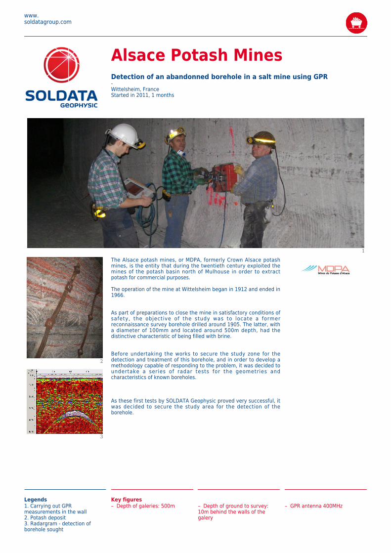
Legends1. Carrying out GPRmeasurements in the wall2. Potash deposit3. Radargram - detection ofborehole sought
Key figures– Depth of galeries: 500m
– Depth of ground to survey:10m behind the walls of thegalery
– GPR antenna 400MHz
www.soldatagroup.com
Alsace Potash MinesDetection of an abandonned borehole in a salt mine using GPR-Wittelsheim, FranceStarted in 2011, 1 months
1
2
3
The Alsace potash mines, or MDPA, formerly Crown Alsace potashmines, is the entity that during the twentieth century exploited themines of the potash basin north of Mulhouse in order to extractpotash for commercial purposes.
The operation of the mine at Wittelsheim began in 1912 and ended in1966.
As part of preparations to close the mine in satisfactory conditions ofsafety, the objective of the study was to locate a formerreconnaissance survey borehole drilled around 1905. The latter, witha diameter of 100mm and located around 500m depth, had thedistinctive characteristic of being filled with brine.
Before undertaking the works to secure the study zone for thedetection and treatment of this borehole, and in order to develop amethodology capable of responding to the problem, it was decided toundertake a series of radar tests for the geometries andcharacteristics of known boreholes.
As these first tests by SOLDATA Geophysic proved very successful, itwas decided to secure the study area for the detection of theborehole.