All KC events will be approved for public using NASA Form ...€¦ · JSC/EC5 Spacesuit Knowledge...
48
JSC/EC5 Spacesuit Knowledge Capture (KC) Series Synopsis All KC events will be approved for public using NASA Form 1676. This synopsis provides information about the Knowledge Capture event below. Topic: Exploration of Mars with the ChemCam LIBS Instrument and the Curiosity Rover Date: October 25, 2016 Time: 1:00 p.m. – 2:00 p.m. Location: JSC/B29/CR 118 DAA 1676 Form #: 37620 This is a link to the recording of the lecture material \\js-ea-fs-03\pd01\EC\Knowledge-Capture\FY17 Knowledge Capture\20161025 SIPI_Newsom_MSL\1676 - Charts Assessment of Export Control Applicability: This presentation has been reviewed by the EC5 Spacesuit Knowledge Capture Manager in collaboration with the author and is assessed to not contain any technical content that is export controlled. It is requested to be publicly released to the JSC Engineering Academy, as well as to the NASA Technical Library and Scientific and Technical Information (STI) Program for distribution through NASA’s Technical Report Server (NTRS) (public or non-public) and YouTube viewing. Presenter: Dr. Horton E. Newsom Synopsis: The Mars Science Laboratory (MSL) Curiosity rover landed on Mars in August 2012, and has been exploring the planet ever since. Dr. Horton E. Newsom will discuss the MSL’s design and main goal, which is to characterize past environments that may have been conducive to the evolution and sustainability of life. He will also discuss Curiosity’s science payload, and remote sensing, analytical capabilities, and direct discoveries of the Chemistry & Camera (ChemCam) instrument, which is the first Laser Induced Breakdown Spectrometer (LIBS) to operate on another planetary surface and determine the chemistry of the rocks and soils. Biography: Dr. Horton E. Newsom earned his undergraduate degree at the University of California Berkeley, and his doctorate at the University of Arizona, and is currently a senior research scientist and research professor within the Institute of Meteoritics and Department of Earth and Planetary Sciences at the University of New Mexico. He is a geologist and geochemist with more than 40 years of experience with planetary science, including the origin and composition of the Earth and Moon, and the study of terrestrial impact craters around the world and their hydrothermal systems. He has extensively studied surface processes on Mars including impact craters, sedimentary deposits, and phyllosilicate (clay) bearing terrains. He has also studied the origin and chemistry of Martian surficial materials using data from the Mars Odyssey Gamma Ray spectrometer experiment. Dr. Newsom has been involved with landing site selection for several Mars missions, including the Mars Exploration Rover (MER), Mars Science Laboratory (MSL), and future human landing sites. He is a co-investigator and science team member on the ChemCam Laser Induced Breakdown Spectroscopy (LIBS) instrument on the MSL “Curiosity,” currently investigating habitable terrains on Mars. Dr. Newsom is actively involved with the daily operations of Curiosity, including planning science observations, and publication of the results. Dr. https://ntrs.nasa.gov/search.jsp?R=20160012384 2020-05-22T01:25:58+00:00Z
Transcript of All KC events will be approved for public using NASA Form ...€¦ · JSC/EC5 Spacesuit Knowledge...

JSC/EC5 Spacesuit Knowledge Capture (KC) Series Synopsis
All KC events will be approved for public using NASA Form 1676.
This synopsis provides information about the Knowledge Capture event below.
Topic: Exploration of Mars with the ChemCam LIBS Instrument and the Curiosity Rover
Date: October 25, 2016 Time: 1:00 p.m. – 2:00 p.m. Location: JSC/B29/CR 118
DAA 1676 Form #: 37620
This is a link to the recording of the lecture material \\js-ea-fs-03\pd01\EC\Knowledge-Capture\FY17 Knowledge Capture\20161025 SIPI_Newsom_MSL\1676 - Charts
Assessment of Export Control Applicability:
This presentation has been reviewed by the EC5 Spacesuit Knowledge Capture Manager in collaboration with the author and is assessed to not contain any technical content that is export controlled. It is requested to be publicly released to the JSC Engineering Academy, as well as to the NASA Technical Library and Scientific and Technical Information (STI) Program for distribution through NASA’s Technical Report Server (NTRS) (public or non-public) and YouTube viewing.
Presenter: Dr. Horton E. Newsom
Synopsis: The Mars Science Laboratory (MSL) Curiosity rover landed on Mars in August 2012, and has been exploring the planet ever since. Dr. Horton E. Newsom will discuss the MSL’s design and main goal, which is to characterize past environments that may have been conducive to the evolution and sustainability of life. He will also discuss Curiosity’s science payload, and remote sensing, analytical capabilities, and direct discoveries of the Chemistry & Camera (ChemCam) instrument, which is the first Laser Induced Breakdown Spectrometer (LIBS) to operate on another planetary surface and determine the chemistry of the rocks and soils.
Biography: Dr. Horton E. Newsom earned his undergraduate degree at the University of California Berkeley, and his doctorate at the University of Arizona, and is currently a senior research scientist and research professor within the Institute of Meteoritics and Department of Earth and Planetary Sciences at the University of New Mexico. He is a geologist and geochemist with more than 40 years of experience with planetary science, including the origin and composition of the Earth and Moon, and the study of terrestrial impact craters around the world and their hydrothermal systems. He has extensively studied surface processes on Mars including impact craters, sedimentary deposits, and phyllosilicate (clay) bearing terrains. He has also studied the origin and chemistry of Martian surficial materials using data from the Mars Odyssey Gamma Ray spectrometer experiment. Dr. Newsom has been involved with landing site selection for several Mars missions, including the Mars Exploration Rover (MER), Mars Science Laboratory (MSL), and future human landing sites. He is a co-investigator and science team member on the ChemCam Laser Induced Breakdown Spectroscopy (LIBS) instrument on the MSL “Curiosity,” currently investigating habitable terrains on Mars. Dr. Newsom is actively involved with the daily operations of Curiosity, including planning science observations, and publication of the results. Dr.
https://ntrs.nasa.gov/search.jsp?R=20160012384 2020-05-22T01:25:58+00:00Z

Newsom is also responsible for advisement of undergraduate, graduate, and postdoctoral student research, and has been extensively involved in NASA-funded educational outreach to K-12 teachers, and to local middle school and high school students, and Native American colleges.
EC5 Spacesuit Knowledge Capture POCs: Cinda Chullen, Manager [email protected] (281) 483-8384 Vladenka Oliva, Technical Editor (Jacobs) [email protected] (281) 461-5681

Horton Newsom, Univ. of New Mexico,MSL Science Team, 10/25/2016
NASA/JPL-Caltech/MSSS
The Exploration of Mars With the ChemCam LIBS Instrument and the Curiosity Rover
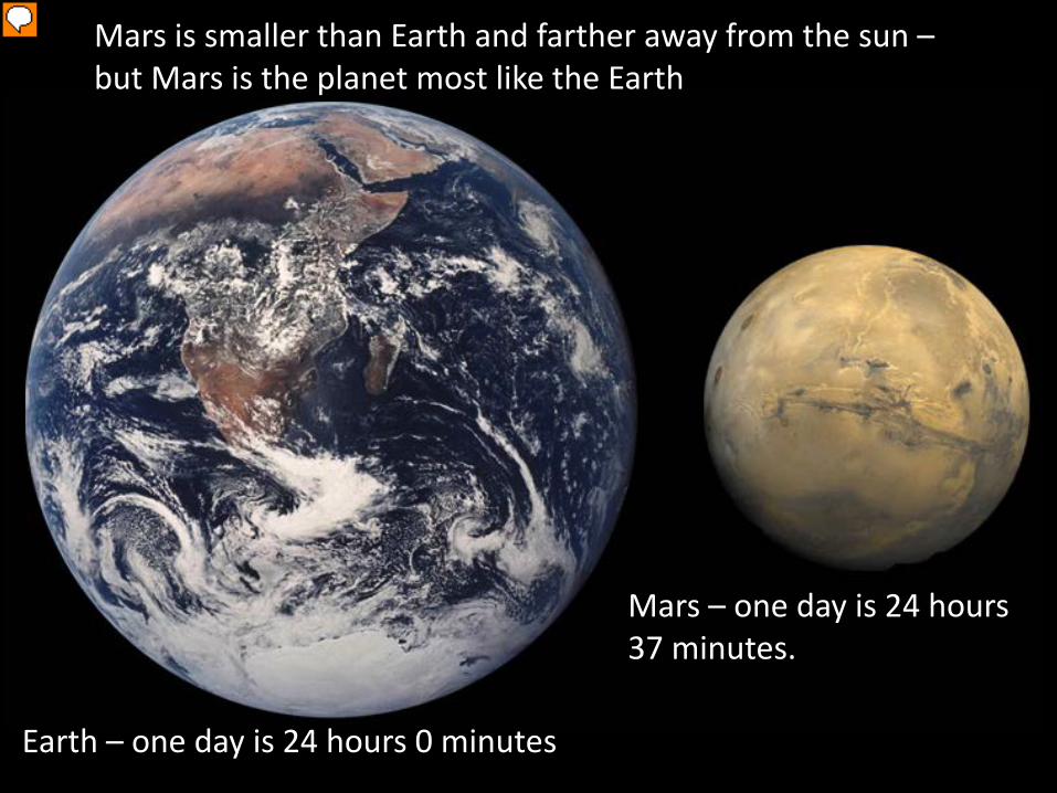
Mars is smaller than Earth and farther away from the sun –but Mars is the planet most like the Earth
Earth – one day is 24 hours 0 minutes
Mars – one day is 24 hours 37 minutes.
Presenter
Presentation Notes
Scale images of Earth and Mars. Mars is 1/10th the mass of Earth; over time it has lost nearly all of its atmosphere and much of its water due to the lower gravity. We’re interested in the time period when Mars was more habitable.

MRO
ESA Mars Express
Odyssey
MER (1 still going)
20132011Operational
Mars Science Laboratory
2001-2007
MAVEN Aeronomy Orbiter
2009 2016 2018 2020ESA—RussiaExoMarsTraceGas Orbiter
ESA-Russia Rover: ExoMars
ESA—EDLDemonstrator
2022 &beyond
Mars 2020 –sample caching
InSIGHT geohysicallander
India -Mangalyaanorbiter
Mars samplereturn
UAE-Hope Orbiter
Space-X -Red Dragon?
China -orbiter/rover?
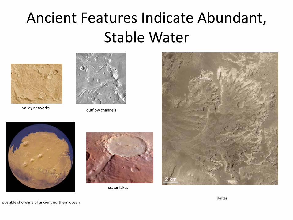
Ancient Features Indicate Abundant, Stable Water
valley networks outflow channels
crater lakes
deltaspossible shoreline of ancient northern ocean

Curiosity’s Science Objectives
NASA/JPL-Caltech
Curiosity’s primary scientific goal is to explore a local region on Mars’ surface as a potential habitat for life, past or present
• Could life have existed there?
• Geological history and role of water
• Surface radiation (important for future human exploration)

How to get to Mars?
6 years of construction, launch November 26, 2011,
8 months travel to Mars, landing August 6, 2012
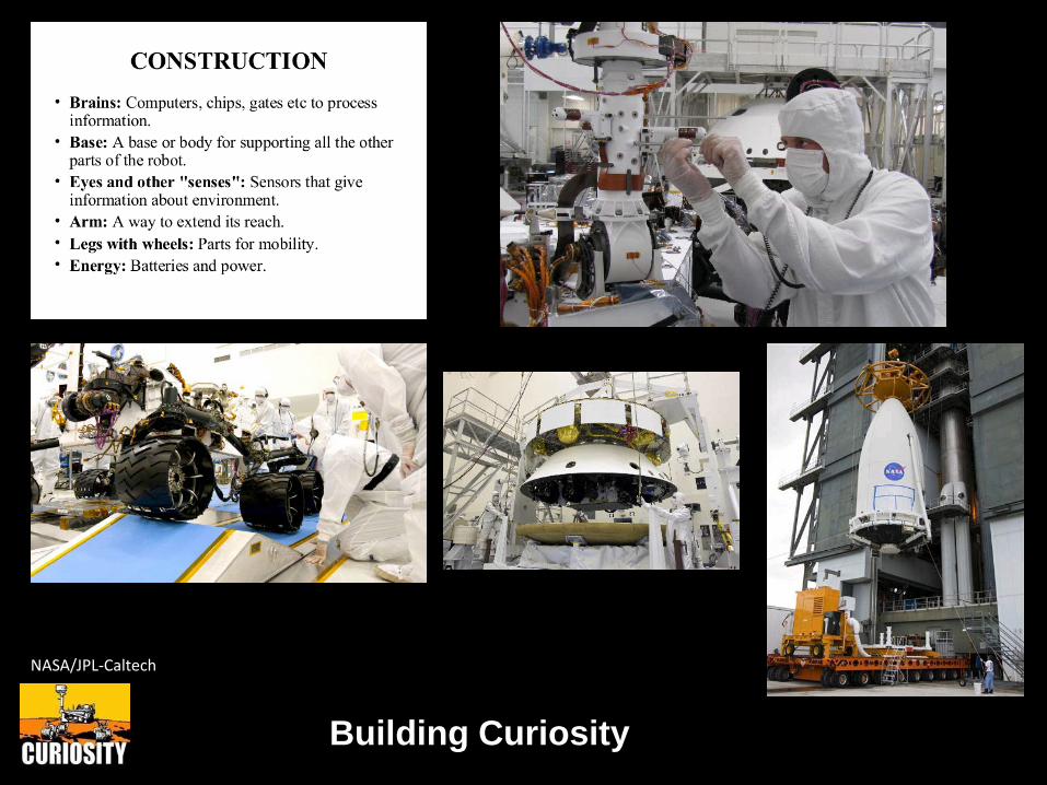
Building Curiosity
NASA/JPL-Caltech
Deep crater with evidence for sedimentary deposits from rivers and lakes

At the test-bed rover during Operational Readiness Test in March 2012
Curiosity is big!
This is the twin of Curiosity (called the test-bed) used on Earth to test how to use Curiosity
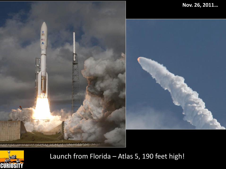
Launch from Florida – Atlas 5, 190 feet high!
Nov. 26, 2011…

Curiosity during landing on parachute, imaged byHiRISE on the Mars Reconnaissance Orbiter satellite
NASA/JPL-Caltech/Univ. of Arizona
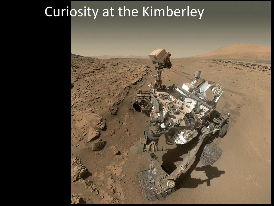
Curiosity at the Kimberley

Curiosity at the Kimberley
What ChemCam does!


ChemCam Block Diagram

15
ChemCam Mast Unit: Optical Box
GALILEAN
LIBS laser beam expansion
LIBS LASER
Nd:KGW 1067 nm
30-50 5 ns pulses, 1-10 Hz,
each ≤ 35 mJ
OPTICAL FIBER connector
To Body UnitTELESCOPE
LIBS laser beam focus and plasma
collection
Target from 2 to 7 m
(1.56 m for cal targets)
CAMERA
(Remote Micro-Imager)
~20 µrad/pixel
SCHMIDT PLATE
Image correction
AUTOFOCUS
Continuous Wave Laser diode
(no longer working)

ChemCam Spectra
~0.049 nm/pixel ~0.042 nm/pixel ~0.21 nm/pixel
can also be used in passive mode

17
LIBS Sensitivities, ChemCam Configuration
B C N O F Ne
Na Mg
Li Be
H He
Al Si P S Cl Ar
Ga Ge As Se Br Kr
In Sn Sb Te I Xe
Tl Pb Bi
Mn Fe Co Ni Cu Zn
Ru Rh Pd Ag Cd
Re Os Ir Pt Au Hg
K Ca Sc Ti V Cr
Rb Sr Y Zr Nb Mo
Cs Ba La Hf Ta W
5-100 ppm
100-1000 ppm
0.1-5%
Difficult
Approximate detection limitsat Mars atmospheric pressure
Observed on Mars so far

Pointing: Accuracy is ±2 mrad (4-14 mm), but precision (between points) is much finer
PointsSize is ~0.3-0.6 mmEach consist of 30-50 shots
- depth profile, ~100 µm in rock, a few mm in soil
Commonly separated by 2 mrad
Baseline RastersLine (horizontal, vertical, diagonal): 1x5, 5x1, 1x10, 10x1 Grid: 3x3, 5x5Single point: 1x1 (generally calibration targets only)

Gale Crater
• Geologic potpourri for Mars• Stratigraphic succession of sedimentary
layers 5.5 km thick• Geomorphology: Dried alluvial fans,channels, and deltas; sand dunes; yardangs

Le Mouélic et al. [2014]
Long Distance RMI Imaging
With a pixel scale nearly 4x finer than Mastcam, ChemCam’s Remote Micro-Imager can discern ~ 5cmobjects 1 km away. It is very useful in assessing distantoutcrops, dunes, and other features.

Current Location
Major Science Results
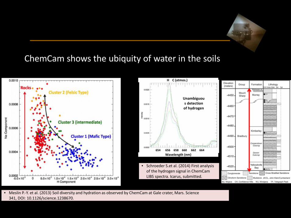
Hydrated soil and dust
ChemCam shows the ubiquity of water in the soils
• Meslin P.-Y. et al. (2013) Soil diversity and hydration as observed by ChemCam at Gale crater, Mars. Science341, DOI: 10.1126/science.1238670.
654 656 658 660 662 664666Wavelength (nm)
H C (atmos.)
Unambiguous detectionof hydrogen
• Schroeder S.et al. (2014) First analysisof the hydrogen signal in ChemCamLIBS spectra. Icarus, submitted.
Stimson ss

Ca-sulfate veins, variable hydrationCalcium sulfate veins, of variable hydration, are in all the sedimentary rocks along MSL’s traverse so far
Unambiguousdetectionof Ca and S
• Nachon M. et al. (2013) Calcium sulfate veinscharacterized by the ChemCam instrument atGale crater, Mars. J. Geophys. Res., accepted.
Chemostratigraphy with ChemCam laser
Stimson ss

Fe-rich cements in sedimentsAnalysis of conglomerates shows strong evidence for iron-bearing cement.
• Williams R. et al. (2013) Martian fluvial conglomerates at GaleCrater. Science 340, 1068-1072, DOI: 10.1126/science.1237317.
• Blaney D. et al. (2013) Chemistry and texture of the rocks at“Rocknest”, Gale crater: Evidence for iron-rich cements. J. Geophys.Res., submitted.
Stimson ss
D
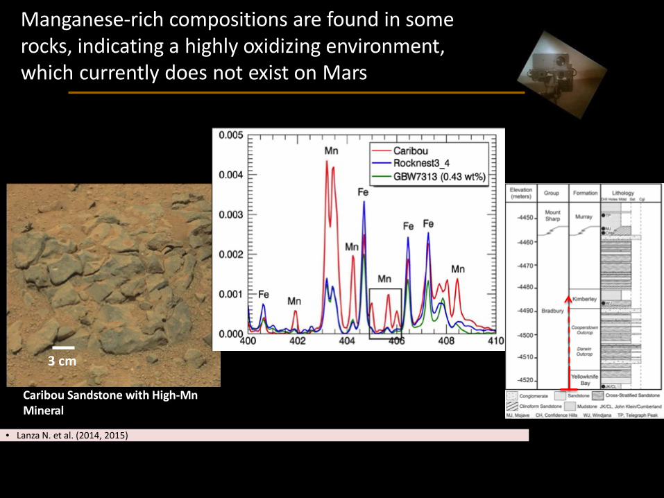
First manganese-rich minerals
Manganese-rich compositions are found in some rocks, indicating a highly oxidizing environment,which currently does not exist on Mars
3 cm
Caribou Sandstone with High-MnMineral
• Lanza N. et al. (2014, 2015)

Potassic-rich sandstones, probably from a detrital source (low CAI index), are found into increase upward within the Bradbury formation (strata below Mt. Sharp) [Le Deit et al., 2015]
Stimson ss

Curiosity discovered south-tilted sandstone beds on Gale Crater’s plains that indicate water-driven transport of sediment, building lower Mount Sharp from lake deposits
NASA/JPL-Caltech/GSFC
Possible lake deposits at the base of Mount Sharp
Mount Sharp

Mineral veins of varying composition fill fractures within the lake-formed mudstone, indicating multiple generations of interaction with liquid water. ChemCam has been critical in the vein analyses.

At Marias Pass, Curiosity discovered significant enrichments of silica in the mudstone. The Buckskin drill sample contained amorphous silica as well as the mineral tridymite that likely originated from a silica-rich volcanic source.
Center-Dipping Beds Deposited as Gale Lake Filled with Sediment
NASA/JPL-Caltech/MSSS
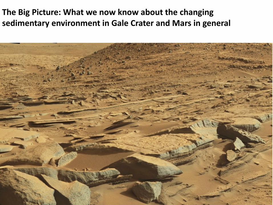
The Big Picture: What we now know about the changing sedimentary environment in Gale Crater and Mars in general

Grotzinger et al. (2015), Sci. #350
~3.8 billion years
Central peak
North rim
clays
Basement rocks
conglomeratessandstone

~3.3 billion years
Central peak
North rim
Sloping rock beds
Clays
Basement rocks
conglomeratessandstones
Grotzinger et al. (2015), Sci. #350
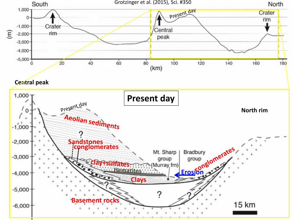
Present day
Central peak
North rim
ErosionClays
Basement rocks
conglomeratesSandstones
Grotzinger et al. (2015), Sci. #350

Present day
Central peak
nördlicheKraterwand
Grotzinger et al. (2015), Sci. #350
Erosion
clays (~5 mm) clays (~10 mm)
Fluvial sandstones(transport rt to left)
conglomerates
clays
Basement rocks
conglomeratesSandstones

Sampling sand
dunes
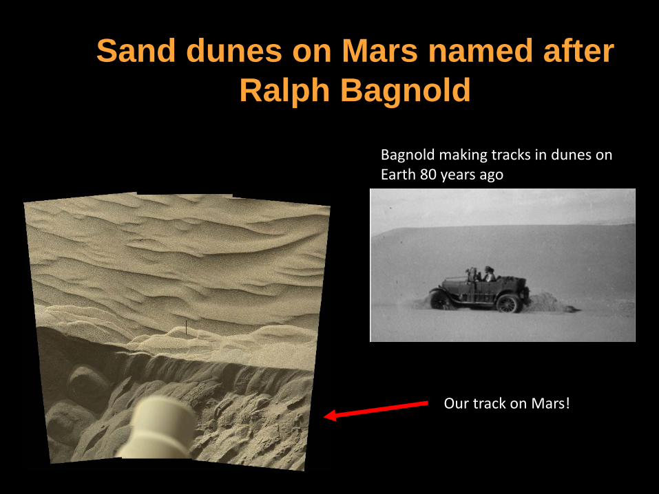
Sand dunes on Mars named after Ralph Bagnold
Bagnold making tracks in dunes on Earth 80 years ago
Our track on Mars!
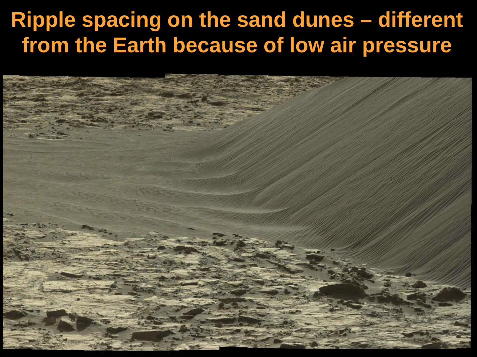
Ripple spacing on the sand dunes – different from the Earth because of low air pressure

The future - we are driving up an 18,000-foot high mountain (Mt. Sharp)

Future Targets on Lower Mount Sharp
NASA/JPL-Caltech/Univ. of Arizona
(Murray Buttes)
Stream Channel
NASA/JPL-Caltech/MSSS
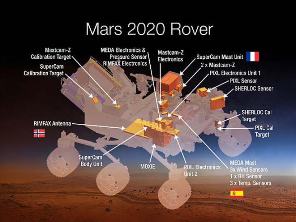

2020 Rover Plans:
• Collect samples for future return to Earth
• Demonstrate production of oxygen for future astronauts
• Explore a new area of Mars

Thank You For Your Attention!

JSC/EC5 Spacesuit Knowledge Capture (KC) Series Synopsis
All KC events will be approved for public using NASA Form 1676.
This synopsis provides information about the Knowledge Capture event below.
Topic: Exploration of Mars with the ChemCam LIBS Instrument and the Curiosity Rover
Date: October 25, 2016 Time: 1:00 p.m. – 2:00 p.m. Location: NESC Academy Online
DAA 1676 Form #: 38006
This is a link to the recording of the lecture material and questions and answers that resulted from that event \\js-ea-fs-03\pd01\EC\Knowledge-Capture\FY17 Knowledge Capture\20161025 SIPI_Newsom_MSL\1676 - Video
Assessment of Export Control Applicability:
This video of the presentation, along with the questions and answers, have been reviewed by the EC5 Spacesuit Knowledge Capture manager in collaboration with the author and are assessed to not contain any technical content that is export controlled. It is requested to be publicly released to the NASA Engineering and Safety Center (NESC) Academy Online, the JSC Engineering Academy, and NASA Technical Library and Scientific and Technical Information (STI) Program for distribution through NASA’s Technical Report Server (NTRS) (public or non-public) and YouTube viewing.
Presenter: Dr. Horton E. Newsom
Synopsis: The Mars Science Laboratory (MSL) Curiosity rover landed on Mars in August 2012, and has been exploring the planet ever since. Dr. Horton E. Newsom will discuss the MSL’s design and main goal, which is to characterize past environments that may have been conducive to the evolution and sustainability of life. He will also discuss Curiosity’s science payload, and remote sensing, analytical capabilities, and direct discoveries of the Chemistry & Camera (ChemCam) instrument, which is the first Laser Induced Breakdown Spectrometer (LIBS) to operate on another planetary surface and determine the chemistry of the rocks and soils.
Biography: Dr. Horton E. Newsom earned his undergraduate degree at the University of California Berkeley, and his doctorate at the University of Arizona, and is currently a senior research scientist and research professor within the Institute of Meteoritics and Department of Earth and Planetary Sciences at the University of New Mexico. He is a geologist and geochemist with more than 40 years of experience with planetary science, including the origin and composition of the Earth and Moon, and the study of terrestrial impact craters around the world and their hydrothermal systems. He has extensively studied surface processes on Mars including impact craters, sedimentary deposits, and phyllosilicate (clay) bearing terrains. He has also studied the origin and chemistry of Martian surficial materials using data from the Mars Odyssey Gamma Ray spectrometer experiment. Dr. Newsom has been involved with landing site selection for several Mars missions, including the Mars Exploration Rover (MER), Mars Science Laboratory (MSL), and future human landing sites. He is a co-investigator and science team member on the ChemCam Laser Induced Breakdown Spectroscopy (LIBS) instrument on the MSL
“Curiosity,” currently investigating habitable terrains on Mars. Dr. Newsom is actively involved with the daily operations of Curiosity, including planning science observations, and publication of the results. Dr. Newsom is also responsible for advisement of undergraduate, graduate, and postdoctoral student research, and has been extensively involved in NASA-funded educational outreach to K-12 teachers, and to local middle school and high school students, and Native American colleges.
EC5 Spacesuit Knowledge Capture POCs: Cinda Chullen, Manager [email protected] (281) 483-8384 Vladenka Oliva, Technical Editor (Jacobs) [email protected] (281) 461-5681

“Exploration of Mars with the ChemCam LIBS Instrument and the Curiosity Rover”
Questions Asked Outside the Knowledge Capture Event Real-Time Broadcast
No. Question Answer 1. How is the baseline raster of known minerals protected from
getting a layer of dust on it and thereafter having the data obtained (presumably for calibration) be altered by the reaction from the baseline raster plus the dust?
We discard the data from the first 5 Laser Induced Breakdown Spectrometer (LIBS) laser shots. The early shots often show evidence of dust. We have documented that the early shots also blow away the surface dust from around the LIBS pits. We have no evidence of any residual dust on calibration targets or most rocks after 5 shots. Shots on soils are different, as some soil grains from the surface can fall into the hole during the sequence.
2. Lunar dust has characteristics that result from the bombardment processes that create multifaceted sharp surfaces and shapes. Those have proved to be a problem in lunar exploration. Those dust grains stay in those shapes because there is no process that moves the dust on the Moon. Has the prevalent shape of sand and dust on Mars been established via detailed photography? Is erosion or grinding due to motion changing the shape of Mars dust to be more circular (and thus less of a problem)?
The highest resolution imager on Mars Science Laboratory (MSL) is the Mars Hand Lens Imager (MAHLI) camera, but it cannot see very fine particles. For larger particles, we see both rounded particles and angular particles. This probably depends on how far they have been transported by water or wind. The surface regolith is much more Earth like than Moon like.
3. Is it possible to predict inner parts of Mars using volcanic ash? I know on Earth we can find the core and mantle parts of Earth using earthquake waves (Seismic waves).
The relevant data are analyses of igneous rocks on Mars by the rovers, Martian meteorites, and the chemistry of the surface of Mars from the Odyssey Gamma Ray Spectrometer experiment. The Insight mission planned for 2018 will do the kind of seismometer measurements done on the Earth as well. Viking had seismometers that failed to record Martian Earthquakes. The available data have been used to infer that Mars has differentiated into a core, mantle, and crust.

No. Question Answer 4. Based on the magnificent volcanoes on Mars; I would
anticipate that layers of material are deposited due to volcanic eruptions. How are volcanic eruption layers discriminated from water flow based deposits? The same question related to layers deposited by dust storms.
There are meter-thick deposits on the volcanoes like Tharsis that are likely to be volcanic ash, which do not have the features of lava flows or fluvial deposits. Their chemistry from the Odyssey Gamma Ray instrument (GRS) is different from other areas and consistent with other volcanic deposits. These are not dust that has a distinctive composition measured by the Mars Exploration Rovers (MER) rovers and Curiosity. The rovers suggest that the deposits from airborne dust are extremely thin in the areas studied, millimeters at best. This finding is consistent with the GRS data that senses much more deeply, showing that the Mars regolith, down to one half meter depth, is not homogenized across the planet, while the dust probably is homogenized. The dust is stirred up by dust devils and rare dust storms.
5. Due to Mars' lower gravity, the forces that act to create layers are different than on Earth. What are some of the results of deposits forming on Mars versus how similar deposits would form on Earth?
The effect of the gravity difference on layering is extremely small. For example the angle of repose of sand (e.g., sand dunes) is virtually the same on Earth and Mars, as frictional forces are so important. However, the low density of the atmosphere can affect the nature of ripples on dunes for example. Also, my research group is actively investigating the alluvial fans in Gale crater, which might have some subtle differences from terrestrial fans, with possibly thinner more sheet flood deposits, but we do not yet have an explanation. Most likely, it has to do with the sources of water when the fan formed before 3.2 billion years ago.