Alderbourne Dossier MASTER 30 Jan 17 · Each dossier includes the following for the ... 1950s‐70s...
16
Understanding Historic Parks and Gardens in Buckinghamshire The Buckinghamshire Gardens Trust Research & Recording Project ALDERBOURNE MANOR May 2017 Bucks Gardens Trust The Stanley Smith (UK) Horticultural Trust
Transcript of Alderbourne Dossier MASTER 30 Jan 17 · Each dossier includes the following for the ... 1950s‐70s...

Understanding Historic Parks and Gardens
in Buckinghamshire
The Buckinghamshire Gardens Trust Research & Recording Project
ALDERBOURNE MANOR
May 2017
Bucks Gardens Trust
The Stanley Smith (UK)
Horticultural Trust
Bucks Gardens Trust, Site Dossier: Alderbourne Manor, Fulmer, South Bucks DC May 2017
1
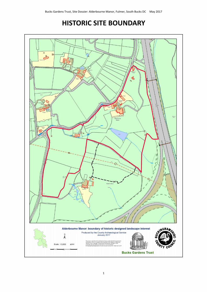
HISTORIC SITE BOUNDARY

Bucks Gardens Trust, Site Dossier: Alderbourne Manor, Fulmer, South Bucks DC May 2017
2
Bucks Gardens Trust, Site Dossier: Alderbourne Manor, Fulmer, South Bucks DC May 2017
3
INTRODUCTION
Background to the Project
This site dossier has been prepared as part of The Buckinghamshire Gardens Trust (BGT) Research
and Recording Project, begun in 2014. This site is one of several hundred designed landscapes
county‐wide identified by Bucks County Council (BCC) in 1998 (including Milton Keynes District) as
potentially retaining evidence of historic interest, as part of the Historic Parks and Gardens Register
Review project carried out for English Heritage (now Historic England) (BCC Report No. 508). The list is not definitive
and further parks and gardens may be identified as research continues or further information comes to light.
Content
BGT has taken the Register Review list as a sound basis from which to select sites for appraisal as
part of its Research and Recording Project for designed landscapes in the historic county of Bucks
(pre‐1974 boundaries). For each site a dossier is prepared by volunteers trained on behalf of BGT by experts in
appraising designed landscapes who have worked extensively for English Heritage/Historic England on its Register
Upgrade Project.
Each dossier includes the following for the site:
A site boundary mapped on the current Ordnance Survey to indicate the extent of the main part of the
surviving designed landscape, also a current aerial photograph.
A statement of historic significance based on the four Interests outlined in the National
Policy Planning Framework and including an overview.
A written description, derived from documentary research and a site visit, based on the
format of the English Heritage (now Historic England) Register of Parks & Gardens of special
historic interest 2nd edn.
A map showing principal views and features.
The area within the site boundary represents the significant coherent remains of the designed
landscape. It does not necessarily include all surviving elements of the historical landscape design,
which may be fragmented. It takes no account of current ownership.
NOTE: Sites are not open to the public unless advertised elsewhere.
Supporters and Acknowledgements
The project was supported by The Gardens Trust (formerly the Association of Gardens Trusts and the Garden History
Society) and funded by BGT with significant grants from the Stanley Smith Horticultural Trust and the Finnis Scott
Foundation. BCC generously provided current and historic mapping and access to the Historic Environment Record.
The Trust would like to thank the volunteers and owners who have participated in this project and
given so much time and effort to complete this challenging and rewarding task.
Further information is available from: www.bucksgardenstrust.org.uk

Bucks Gardens Trust, Site Dossier: Alderbourne Manor, Fulmer, South Bucks DC May 2017
4
COUNTY: BUCKINGHAMSHIRE ALDERBOURNE MANOR (FORMERLY LODGE)
DISTRICT: SOUTH BUCKS
PARISH: Langley Marish, Denham,
Iver
BCC HER 0524600000
OS REF.: TO 015 865
STATEMENT OF SIGNIFICANCE
Overview
A typical mid‐C19 Chiltern villa ensemble, with lawns and pleasure grounds, parkland and associated lodge in the
form of a cottage orné and main drive set in woodland. The lake in the park and much of the garden and pleasure
ground layout and planting established by the early C20 remain. However, they are diminished by the impact of the
motorway constructed through the park and other more recent changes. These include the loss of the kitchen
gardens, and new developments and car parking along the north‐west boundary.
Archaeological interest
There is considerable archaeological potential as several C11 kiln sites are recorded here. There may also be
evidence of former structures demolished after 1845 to make way for the present buildings and layout. Evidence
may survive for lost C19 and C20 garden features, including in the former kitchen gardens. These may include paths,
walls, terracing, glasshouses, and other pleasure ground and park features such as summerhouses and masonry
seats.
Architectural Interest
A typical mid‐C19 country villa ensemble. The villa has an ornamental iron veranda overlooking the gardens, and
adjacent contemporary service buildings, and a more distant lodge in the form of a cottage orné (listed Grade II).
The villa is possibly partly modelled on Henbury Vicarage near Bristol, previous home of Rev. Henry Hugh Way;
members of the Way family were the vicars there from 1830 until 1928.
Artistic Interest
A typical mid‐C19 country villa grounds, including woodland, park and garden. The layout enjoys elevated views over
characteristic rolling Chiltern landscape, including a boating lake in the park; a winding woodland drive approaches
the house. The grounds largely survive, although the former kitchen gardens have gone and some changes have
been made on the north‐west boundary in the late C20/early C21, including in the woodland. Many mature trees
forming part of the ornamental scheme from the mid‐C19 onwards survive.
Historic Interest
The property was associated with the Way family of nearby Denham Place and with Ngiao Marsh. The important
1950s‐70s collection of works of art of the Kahnweilers, now in the Tate Gallery, was housed here, with pieces
placed in the gardens.

Bucks Gardens Trust, Site Dossier: Alderbourne Manor, Fulmer, South Bucks DC May 2017
5
HISTORIC DEVELOPMENT
The manor of Alderbourne belonged to Ankerwycke Priory at the south tip of Bucks until the Dissolution of the
Monasteries (c.mid‐C16) and in the C17 became the property of the Windsor family. By 1769 it had passed into the
ownership of the Way family of nearby Denham Place (VCH).
In 1809 a house, yard and yard buildings stood adjacent to the east of Fulmer Lane with a ‘home field’ to the south‐
east and alongside the lane and Hawks Wood to the south; a wood known as Nutters Grove lay to the north‐
east (Inclosure Map, OSD). This wooded area to the north‐east was called Nutting Grove in 1845, whilst a group of
buildings remained next to the road (estate map, CBS D/TR/9/22c).
One of the first references to the site as Alderbourne Manor is in 1862; ‘Alderbourne Manor, formerly called Nutley
Grove (near to Gerrard’s Cross), now the seat of Rev. Henry Hugh Way’ (Sheahan); it is also called Alderbourne
Manor on maps after 1875 (OS). However, the house is still referred to as Nutting Grove in 1881 (census) and 1883
(Kelly’s Directory).
The Alderbourne estate may have been in the possession of Rev. Henry Hugh Way from about 1852 as documents
exist for the transfer of land in Denham and Iver from Benjamin Way to Rev. Henry Hugh Way (CBS D/W/33‐16).
Certainly, he owned it from 1861 until his death in 1890. Between 1845 (estate map, CBS D/TR/9/22c) and 1875 a
new house and drive with a roadside lodge were built, a building was erected where The Barn now stands and an
extensive network of paths was created, leading through planted areas and woodland (estate map CBS D/TR/9/22c
and OS). The new service yard included the site of the former house, yard and yard buildings (Inclosure map). In the
1870s an area of gardens with glasshouses lay north of the house, between it and the service buildings, with a
further area of what may have been kitchen garden west of this, bordering the road (OS) The lake also appears to
have been created at this time as it does not appear on earlier maps. (estate map, CBS D/TR/9/22c; OS 1875),
probably by damming a stream. A boating house was added subsequently (OS, 1897) but was apparently removed
some time between 1923 and 1941, although it is still shown on a map c1950 and traces of it may remain (OS;
Alderbourne Memories). At some time a ha‐ha was built but had been filled in by 1941 (Memories).
In 1895 Alderbourne Manor was the residence of Viscount Coke (Kelly’s). By 1907 it was the residence of John Bell
White, later High Sheriff of Buckinghamshire, who made alterations to both the manor house and Alderbourne
Manor Farm (Eton RDC plans; census). He was still there in 1919 (Bucks Herald). Between 1900 and 1926 the
network of paths to the west of the manor, around Hawk’s Wood to the south‐west and through the woods adjacent
to the drive to the north‐east was also apparently extended (OS 2nd and 3rd ed).
From about 1927 Alderbourne Manor was the home of Captain Tahu Rhodes and his wife Hon Helen Plunket (The
Tatler Magazine and Gerrards Cross and Chalfont St Peter Road Directory, 1929). The author Dame Ngiao Marsh was
a regular visitor and apparently the Rhodes family appear as the Lampreys in A surfeit of Lampreys (1941)
(Dictionary of New Zealand Biography).
Between 1931 and 1935 it was the home of Murray Adams‐Acton (Gerrards Cross and Chalfont St Peter Road
Directories), a furniture designer and inventor, who designed the dining room to Shirenewton Hall in 1910 and some
of the interiors of Swan & Edgar's shop in Piccadilly in 1927. He was also the author of many books about design and
a keen gardener, noted in particular for his rhododendron cultivation in Scotland in the 1940s.
Alderbourne Manor was then occupied by Major Arthur W. M. Burton and then the de Courcy family
(Gloucestershire Echo 1940 and 1950). The estate was split during the 1950s and between 1958 and 1974 Gustav
Kahnweiler CBE and his wife Elizabeth owned one of the apartments within the manor house. Their collection of
works of art of, now in the Tate Gallery, was housed here (Planning Inspectorate references
APP/NO410/C/15/3078099, 3078100 and 3129769 Ref. No: 16/50001/ENFC).

Bucks Gardens Trust, Site Dossier: Alderbourne Manor, Fulmer, South Bucks DC May 2017
6
Parts of the former wider estate were destroyed or detached by the building of the M25 to the east, between 1971‐
74, and by the construction of the M40 to the south. Electricity pylons installed by 1975 (OS) cut through the woods
and park to the south‐west.
The site remains (2016) in split private ownership. The Manor house and service buildings have been divided (8
flats/maisonettes, Alderbourne House and The North Stables), other buildings are linked houses known as The Barn
and Coach House.
SITE DESCRIPTION
LOCATION, AREA, BOUNDARIES, LANDFORM SETTING
Alderbourne Manor lies chiefly in the parish of Langley Marish, but extends also into the neighbouring parishes of
Denham and Iver. The 16 ha. site lies 1 mile north‐east of Fulmer village in the wooded and agricultural Chilterns on
undulating hilly ground that falls from c.75m AOD southwards to Broadspring Wood and beyond this to the Alder
Bourne. It is bounded by Fulmer Lane to the north‐west, Hawks Wood Lane to the west, and by the M25 to the east
although this cuts across part of the historic estate. The irregular south boundary abuts Hawks Wood and
agricultural land with the M40/M25 junction beyond this.
ENTRANCES AND APPROACHES
The ‘Long Drive’ enters off Fulmer Lane at the lodge, Alderbourne Cottage (listed Grade II), and a spur leads to
parking spaces in front of, and to the side of the cottage. It is an early‐mid C19 cottage orné with a thatched roof
overhanging an open veranda with rustic posts and leaded lights. The drive facade has a central concavity which,
with the welling out of the roof, forms a circular floor area beneath. The roadside elevation has a porch with timber‐
framed gable. It has a central chimney and leaded lights. It is first mapped in 1875 (OS).
The cottage and its 0.25 ha. garden are surrounded by woodland, with a mature holly hedge alongside part of the
boundary with Fulmer Lane. The grounds feature formal gardens with a summer house, workshop and polytunnel.
South of the cottage is a paved terrace with pergola and a further terrace with lawns to the south west. To the north
the mature woodland includes oak ash and beech with wild rhododendrons. This woodland setting is in keeping with
the fashions of the time at which it was built and forms part of the historic setting.
From here the Long Drive winds its way 300m south through Ancient Woodland (believed to date from before 1600),
before turning west for 80m between the woodland and a lawn, to end in a gravelled area bordering the veranda,
below the east, entrance front of Alderbourne Manor. This drive appears by 1875 (OS).
A recently‐created entrance lies south‐west of the lodge, with brick gate piers and gates 60m south‐west of the
entrance to the Long Drive.
A service drive leads from 80m further south west along Fulmer Lane north of the house. This was present by 1845
(CBS D/TR/9/22c). This gives access The Barn and Coach House (private dwellings). This is ungated and flanked by
two low brick walls. It leads to a large area for car parking.
Another former service gateway enters 60m south‐west along Fulmer Lane , north‐north‐west of the house between
brick pillars. This entrance leads to a gravelled area and a row of garages (possibly formerly stables) one block of
which is surmounted by a clock tower. This apparently served the service buildings abutting Fulmer Lane (estate
map, CBS D/TR/9/22c). This area gives access to The North Stables via an electric gate set in a brick wall which leads
to a gravelled parking area.

Bucks Gardens Trust, Site Dossier: Alderbourne Manor, Fulmer, South Bucks DC May 2017
7
A further modern entrance 50m along Fulmer Lane north‐west of the house gives access to a large, gravelled car
park.
PRINCIPAL BUILDING
The manor house and its service buildings are grouped next to the north‐west boundary with Fulmer Lane. They
consist of The Barn and Coach House, Alderbourne House and The North Stables, all now residential. The service
buildings abut Fulmer Lane roughly at the mid‐point of the north‐west edge of the site and the manor stands nearby
to the south‐east. The entrance to the manor faces east, and it overlooks gardens and parkland to the south, east
and west.
The manor house dates from c.1860 (Memories; maps 1845 and OS 1875). The entrance front is to the east, the
garden fronts to the west and south, and the service front to the north. The two‐storey rendered building has a
prominent veranda with ornamental iron pillars set on a low stone terrace wrapping round the south and east sides.
The south front features two full height bay windows overlooking the garden terrace and paddock and boating lake
beyond. It appeared in the television programme ‘The Persuaders!’ in 1970.
(http://avengerland.theavengers.tv/spotting/TotheDeath001.jpg)
The Barn and Coach House is a large thatched house with annexe and 0.5 ha. grounds. This group of buildings did not
appear until 1875 (OS), although a group of buildings near the location described in 1809 (Enclosure) was noted as
‘house, yard and buildings’ which remained in 1845 (CBS D/TR/9/22c). The North Stables is a house created from the
converted stable block which lies off a courtyard north of the manor house.
GARDENS AND PLEASURE GROUNDS
The gardens are enclosed by woodland to the north, east and south. Fulmer Lane forms the boundary to the north‐
west and is marked by a group of shrubs and trees. The Manor lies to the south of the former service buildings
behind a belt of trees and a wall.
The manor garden largely encloses the house, with lawns to the east, south and west. The west lawn leads to a belt
of mature trees and then a lawn dotted with shrubs, bounded by Fulmer Lane to the west and by mature trees on
the remaining sides. East of the Manor and gravel sweep is a further large area of lawn and scattered trees. South of
the Manor steps lead down from the veranda on the south front to a lawn, with steps leading down to a wide gravel
terrace. The terrace run west to east along the southern edge and has three large yew topiaries along it and a
mature cedar near the west end. The terrace was present in the late C19 (OS) and forms a key element of the
garden. Formerly it connected with a path running south to north along the west edge of the lawn to the adjacent
former kitchen garden, now a lawn and car park (OS 1875). Beyond the south lawn is a park paddock overlooked by
the south front and lawn. Formerly the grounds featured a ha‐ha, filled up by 1941, and a garden path from the
manor past an arbour containing a huge natural club [sic] (Memories).
‘Draped Reclining Woman’ by Henry Moore, 1957‐58, was displayed by the Kahnweilers as part of their sculpture
collection on the lawn between the house and the lake (planning appeal 2016) (Planning Inspectorate references
APP/NO410/C/15/3078099, 3078100 and 3129769 Ref. No: 16/50001/ENFC).
PARK
The park comprises areas of grassland to the south of the Manor (the paddock) and to the south‐west. The south‐
sloping paddock is open grassland to the north and to the south contains some mature trees. By the early C20 (OS) it
contained scattered specimen trees, mostly in the south half, including a small group of conifers to the south. It

Bucks Gardens Trust, Site Dossier: Alderbourne Manor, Fulmer, South Bucks DC May 2017
8
adjoined a larger area of parkland to the south‐east leading to Broadspring Wood. This is now largely lost to
motorways with what survives as woodland.
South and west of the paddock lies a 0.25 ha. lake, which has apparently been recently renovated. It is bounded by
early C20 woodland to the west and south (OS) and overlooks the house, south lawns and paddock to the north and
east. It was formerly a boating lake (Memories), with a boathouse in the east corner next to the paddock in the late
C19 and early C20 (OS 1897 and 1926; Memories), traces of which may remain. In the late C19 it was set in open
parkland overlooked by the house and south terrace in the gardens to the north (OS 1875).
The area of former park west of Hawk’s Wood is bounded by Fulmer Lane to the north, by Hawks Wood Lane to the
west, and by Hawks Wood to the east and south. Now open, it formerly contained a fenced roundel of trees in the
north half, close to the present electricity pylon.
Hawks Wood encloses the paddock and lake to the south‐west. It may still contain the graves of horses and dogs
owned by former residents (Memories). East of the paddock is part of Gladwin’s Wood.
A network of paths formerly connected the woodlands, linked across the paddock (OS). This may have been used for
shooting activities in the C19/early C20.
KITCHEN GARDEN
The gardens of Alderbourne House at the north end of the park field adjacent to Fulmer Lane may include the
remains of the kitchen garden (OS, late C19). Part of this area is paved whilst the rest is laid to lawn containing a
variety of specimen trees.
REFERENCES
Books and Articles
Bucks Herald (22 November 1919).
Chewton Rose, Gerrards Cross, Sale particulars (2015).
Dept. for Communities and Local Government Planning, APPLICATION REF: 12/00153/FUL (June 2014).
Eton Rural District Council, plans 1896‐1947, http://www.gx2006.co.uk/planning%20applications/d‐
base%20erdc%20%20by%20plan%20number%20and%20date.pdf.
Gerrards Cross and Chalfont St Peter Road Directory (1929), 88.
Gerrards Cross and Chalfont St Peter Road Directory (1931), 82.
Gerrards Cross and Chalfont St Peter Road Directory (1935), 93.
Gloucestershire Echo (8 February 1940, 11 April 1950).
Harrison and Sons, History of the Way Family (1914), 72 ‐76.
Kelly’s Directory of Buckinghamshire (1883), 348.
Kelly’s Directory of Berkshire, Buckinghamshire and Oxon (1895), 106.
Roberts Newby, Gerrards Cross, Sale particulars (April 2014)
Winkworth & Co. Chalfont St. Peter, Sale particulars (2015).
Sheahan, J.J., History and Topography of Buckinghamshire (1862), 864.
Stafford, J., ‘Dame Ngiao Marsh’, Dictionary of New Zealand Biography, Vol. 4, (1998).
The Tatler Magazine (November 1928).
Trevor Kent and Co. Sale particulars (Sept 2014).
Victoria County History, Buckinghamshire
Page, W., (ed.), Victoria County History, Buckinghamshire, Vol. 3 (1925), 294‐301.
Way, Charles P., Alderbourne Memories, (1941) (CBS D192/25/10).

Bucks Gardens Trust, Site Dossier: Alderbourne Manor, Fulmer, South Bucks DC May 2017
9
MAPS
Centre for Bucks Studies
1660 (DX/1139).
1809, Inclosure Map of the Parish of Langley Marish, surveyed by John Woodcock (IR55).
1845, Map of Alderbourne Manor (D/TR/9/22c).
Ordnance Survey
1810 2” draft Ordnance Surveyor’s Drawing (BL)
1st edition 6” surveyed 1875, pub. 1883
2nd edition 6” surveyed 1897, pub. 1900
3rd edition 6” rev 1923, pub. 1926
1st edition 25” surveyed 1875, pub. 1877
2nd edition 25” surveyed 1897, pub. 1899
3rd edition 25” surveyed 1923, pub. 1925
6” 1950s National Grid Provisional Ed.
1:10,000 1975 National Grid
IMAGES
Black and white aerial photographs 1945, 1947, 1951, 1955, 1974, 1979 and 1985 and colour aerial photographs
1989, 1995, 1999, 2003 and 2012 (BCC HER).
http://www.zoopla.co.uk/property‐history/the‐barn/fulmer‐lane/gerrards‐cross/sl9‐7bl/29540719
http://www.henburybrentrycommunity.org.uk/wordpress/wp‐content/uploads/2011/04/Old‐Vicarage.pdf
http://www.rightmove.co.uk/house‐prices/detailMatching.html?prop=51716977&sale=1901929&country=england
http://www.zoopla.co.uk/property‐history/alderbourne‐house/fulmer‐lane/gerrards‐cross/sl9‐7bl/36219098
http://www.zoopla.co.uk/property‐history/flat‐4/alderbourne‐manor/fulmer‐lane/gerrards‐cross/sl9‐7bl/28211096
http://avengerland.theavengers.tv/spotting/TotheDeath001.jpg
Archival Items
Centre for Bucks Studies
D/W/91
D/W/33‐16 Agreement for Exchange Benjamin Way and Rev Henry Hugh Way, land in Denham and Iver.
Gill Grocott November 2016 SR edited May 2017

Bucks Gardens Trust, Site Dossier: Alderbourne Manor, Fulmer, South Bucks DC May 2017
10
KEY HISTORIC VIEWS AND FEATURES
1
3
2
4 5
6
7
8
3
6
9
10
13
14
10
11
12
Bucks Gardens Trust, Site Dossier: Alderbourne Manor, Fulmer, South Bucks DC May 2017
11
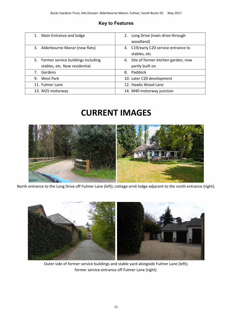
Key to Features
1. Main Entrance and lodge 2. Long Drive (main drive through
woodland)
3. Alderbourne Manor (now flats) 4. C19/early C20 service entrance to
stables, etc
5. Former service buildings including
stables, etc. Now residential.
6. Site of former kitchen garden, now
partly built on
7. Gardens 8. Paddock
9. West Park 10. Later C20 development
11. Fulmer Lane 12. Hawks Wood Lane
13. M25 motorway 14. M40 motorway junction
CURRENT IMAGES
North entrance to the Long Drive off Fulmer Lane (left); cottage orné lodge adjacent to the north entrance (right).
Outer side of former service buildings and stable yard alongside Fulmer Lane (left);
former service entrance off Fulmer Lane (right).
Bucks Gardens Trust, Site Dossier: Alderbourne Manor, Fulmer, South Bucks DC May 2017
12
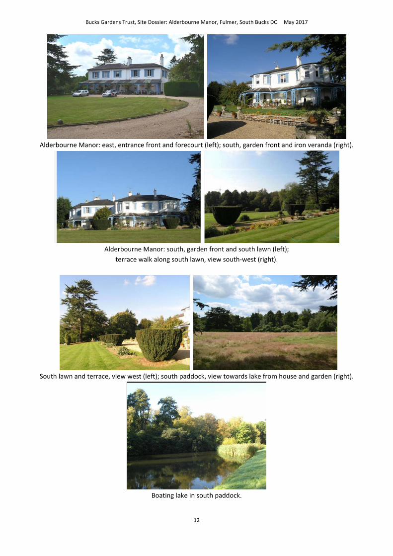
Alderbourne Manor: east, entrance front and forecourt (left); south, garden front and iron veranda (right).
Alderbourne Manor: south, garden front and south lawn (left);
terrace walk along south lawn, view south‐west (right).
South lawn and terrace, view west (left); south paddock, view towards lake from house and garden (right).
Boating lake in south paddock.

Bucks Gardens Trust, Site Dossier: Alderbourne Manor, Fulmer, South Bucks DC May 2017
13
Historic Documents
The garden ‘Under one of the Great Oak Trees’, c.1885 (?Memories) (left);
‘Draped Reclining Woman’, Henry Moore, possibly the piece formerly displayed at Alderbourne by the Kahnweilers,
now in the Tate Gallery (Right).
1809 Inclosure Map (CBS IR55); the previous group of buildings are at top right.

Bucks Gardens Trust, Site Dossier: Alderbourne Manor, Fulmer, South Bucks DC May 2017
14
1845 Sale plan before the present house built and landscape laid out by the Revd Way (CBS D/TR/9/22c).
Ordnance Survey 25” surveyed 1875.

Bucks Gardens Trust, Site Dossier: Alderbourne Manor, Fulmer, South Bucks DC May 2017
15
Ordnance Survey 25” surveyed early C20