ALABAMA DEPARTMENT OF ENVIRONMENTAL … DEPARTMENT OF ENVIRONMENTAL MANAGEMENT COASTAL AREA...
44
ALABAMA DEPARTMENT OF ENVIRONMENTAL MANAGEMENT COASTAL AREA MANAGEMENT PROGRAM DIVISION 335-8 1400 Coliseum Montgomery, Alabama 36110-2059 (334) 271-7700 CITE AS ADEM Admin. Code R. 335-8-x-.xx REVISED EFFECTIVE: MAY 28, 2013
-
Upload
duongkhanh -
Category
Documents
-
view
223 -
download
4
Transcript of ALABAMA DEPARTMENT OF ENVIRONMENTAL … DEPARTMENT OF ENVIRONMENTAL MANAGEMENT COASTAL AREA...
ALABAMA DEPARTMENT OF ENVIRONMENTAL MANAGEMENT
COASTAL AREA MANAGEMENT PROGRAM
DIVISION 335-8
1400 Coliseum Montgomery, Alabama 36110-2059
(334) 271-7700
CITE AS
ADEM Admin. Code R. 335-8-x-.xx
REVISED EFFECTIVE: MAY 28, 2013

i
ALABAMA DEPARTMENT OF ENVIRONMENTAL MANAGEMENT
COASTAL AREA MANAGEMENT PROGRAM CHAPTER 335-8
TABLE OF CONTENTS
Chapter 335-8-1 General Provisions and Review Process Page No.
335-8-1-.01 Purpose ................................................................... 1-1 335-8-1-.02 Definitions ............................................................... 1-1 335-8-1-.03 Review Process Generally ......................................... 1-11 335-8-1-.04 Special Management Areas ....................................... 1-12 335-8-1-.05 Permissible Uses ...................................................... 1-13 335-8-1-.06 (Reserved) ................................................................ 1-15 335-8-1-.07 General Conditions .................................................. 1-15 335-8-1-.08 Review Process for State Agency Permits ................... 1-16 335-8-1-.09 Review Process for Federally Regulated Activities ...... 1-17 335-8-1-.10 Review Process for Federal Projects, Activities and
Assistance ................................................................ 1-21 335-8-1-.11 Review Process for Non-Regulated Uses .................... 1-22 335-8-1-.12 Review Process for Local Program Delegation ............ 1-23 335-8-1-.13 Variances ................................................................. 1-24 335-8-1-.14 Public Notice and Hearings ....................................... 1-25
Chapter 335-8-2 Provisions Related to Coastal Activities
335-8-2-.01 General Rules Applicable to All Uses Subject to the ACAMP .................................................................... 2-1
335-8-2-.02 Dredging and/or Filling ............................................ 2-2 335-8-2-.03 Mitigation ............................................................... 2-3 335-8-2-.04 Marinas ................................................................... 2-4 335-8-2-.05 Piers, Docks, Boathouses, and Other Pile
Supported Structures ............................................... 2-5 335-8-2-.06 Shoreline Stabilization and Erosion Mitigation .......... 2-5 335-8-2-.07 Canals, Ditches, and Boatslips ................................. 2-6 335-8-2-.08 Construction and Other Activities on Gulf Beaches
and Dunes ............................................................... 2-6 335-8-2-.09 Groundwater Extraction ........................................... 2-9 335-8-2-.10 Siting, Construction and Operation of Energy
Facilities .................................................................. 2-11 335-8-2-.11 Commercial and Residential Development ................ 2-12 335-8-2-.12 Discharges to Coastal Waters ................................... 2-13

1-1
ALABAMA DEPARTMENT OF ENVIRONMENTAL MANAGEMENT COASTAL AREA MANAGEMENT PROGRAM
CHAPTER 335-8-1
GENERAL PROVISIONS AND REVIEW PROCESS
TABLE OF CONTENTS 335-8-1-.01 Purpose 335-8-1-.02 Definitions 335-8-1-.03 Review Process Generally 335-8-1-.04 Special Management Areas 335-8-1-.05 Permissible Uses 335-8-1-.06 (Reserved) 335-8-1-.07 General Conditions 335-8-1-.08 Review Process for State Agency Permits 335-8-1-.09 Review Process for Federally Regulated Activities 335-8-1-.10 Review Process for Federal Projects, Activities and Assistance 335-8-1-.11 Review Process for Non-Regulated Uses 335-8-1-.12 Review Process for Local Program Delegation 335-8-1-.13 Variances 335-8-1-.14 Public Notice and Hearings
335-8-1-.01 Purpose.
(1) This Division is promulgated for the purpose of establishing rules and procedures to administer the permitting, regulatory and enforcement functions of the Alabama Coastal Area Management Program (ACAMP) consistent with Legislative requirements and intent. (2) In an effort to avoid duplication of permitting or review efforts of state and federal resource agencies, the Department may rely on the findings and conclusions of such agencies relative to a proposed use's impact on coastal resources. Author: John C. Carlton. Statutory Authority: Code of Alabama 1975, §§ 9-7-16, 22-22A-5, 22-22A-6, 22-22A-8. History: (effective date) June 30, 1994.
335-8-1-.02 Definitions. For the purposes of this Division, the following words and phrases, unless a different meaning is plainly required by the context, shall have the following meanings: (a) "Adjacent Wetlands" means those wetland areas bordering, contiguous, neighboring, or hydrologically contiguous to state waters and/or wetland ecosystems.
335-8-1-.02
1-2
(b) "Agency" means any unit, department, or office of federal, state or local government, including subdivisions thereof. (c) "Alabama Coastal Area Management Program" or "ACAMP" (see definition of "management program") (d) "Alternative Site" means a physical geographic location, either on the same parcel of property or another parcel of property in the same vicinity, which could result in a use having fewer adverse impacts on coastal resources. (e) "Areas of Preservation and Restoration" means a special group of Geographic Areas of Particular Concern singled out because of their conservation, recreational, ecological, or aesthetic values. (f) "Beach" means a sandy shoreline area characterized by low relief, generally of gentle slope, and some vegetation. The beach extends from the waterline to a change in physiographic form such as a dune or bluff, a change in sediment type, such as clay from sand, and/or a change in vegetation type. Gulf beaches are those sand beaches of the mainland and islands in Alabama which are subjected to the direct wave action of the Gulf of Mexico. The upper limit of Gulf beaches is usually a transition from halophytic, succulent, prostrate plant forms such as Hydrocotyle bonariensis (pennywort), Cakile edentula (sea rocket), Iva imbricata (marsh or seashore elder), and Ipomoea stolonifera (seaside morning glory) to a zone occupied by grasses, shrubs, and the same prostrate forms mentioned above. (g) "Boathouse" means a structure, constructed over water, designed or intended to be used for the purpose of docking, storing and protecting one or more watercraft. (h) "Boatslip" means an excavated basin whose length is no greater than twice its width and which is used for the dockage of watercraft. (i) "Canal" means an excavated waterway for the purpose of navigation whose bottom elevation is below mean low water. (j) "Certificate of Compliance" means a document sent to a state agency certifying that the Department has determined the proposed use is in compliance with the Coastal Area Management Program. (k) "Coastal Area" means the waters (including the lands therein and thereunder) and the adjacent shorelands (including the waters therein and thereunder) lying seaward of the continuous 10 foot contour (as defined below) extending seaward to the outer limit of the United States territorial sea. The inland boundaries of the coastal area are described as follows: begin at the southernmost point of the Mississippi-Alabama state line where the land surface elevation reaches 10 feet above mean sea level and continue in a general easterly direction along the 10-foot contour to the proximity of Mobile Bay; continue in a northerly direction on the 10-foot contour along the western shore of Mobile Bay and the Mobile River delta to the north line of Mobile County; thence southeastward along the north line of Mobile County to the intersection with the Baldwin County line in the Mobile River; thence along the west and north lines of Baldwin County in the Mobile and Alabama Rivers to the intersection of the westernmost point of Baldwin County where the land
335-8-1-.02
1-3
surface altitude reaches 10 feet above mean sea level; thence along the 10-foot contour in a southwesterly and southern direction along the Alabama River, the Mobile River delta and the east shore of Mobile Bay to the proximity of Bon Secour; thence continue along the 10-foot contour in an easterly and northeasterly direction to the Alabama-Florida state line. (l) "Coastal Resources" means valuable human, natural, cultural or historical assets within the coastal area, such as water quality, air quality, wetlands and submersed grassbeds, beaches and dunes, wildlife habitats, biological resources, and water resources. (m) "Coastal Waters" means those waters, adjacent to the shoreline, which contain a measurable quantity or percentage of sea water, including but not limited to, sounds, bays, lagoons, bayous, ponds and estuaries. (n) "Consistency Certification" means a document submitted by an applicant for a federal license, federal permit or activity described in an Outer Continental Shelf Lands Plan stating that a use proposed to be undertaken is consistent with the management program and complies with all relevant rules and regulations. (o) "Consistency Determination" means a document sent to the Department by any federal agency stating that a use proposed to be undertaken by that federal agency is consistent with the management program and complies with all relevant rules and regulations. (p) "Construction Control Line" or "CCL" means 1. between plane coordinates (x = 396,624.613 feet; y = 83,299.904 feet) in the vicinity of BC-19 and (x = 445,081.633 feet; y = 90,661.100 feet) in the vicinity of BC-20, a line running parallel to the shoreline at a point 40 linear feet inland of the most inland point of the crestline; except in the BTL (business, tourist and lodging) and BCR (business, central resort) zones of the City of Gulf Shores as defined on July 16, 1984 by the zoning maps of the City of Gulf Shores, wherein the construction control line means a line running parallel to the crestline at a point five linear feet inland of the most inland point of the crestline; 2. the northern property line of an area known as West Surf Beach of Dauphin Island, Mobile County, Alabama, according to the 1953 subdivision of Dauphin Island, map book 7, pp. 1-21, otherwise known as the southern property line of Block WS Fractional Lot A, and Blocks 101, 103, 105, 107 and 109, as well as the northern property line of the western most part of the area known as West Surf Beach, according to the 1953 Subdivision of Dauphin Island, map book 8, p. 227, otherwise known as the southern property line of Blocks A through T, inclusive. 3. in Mobile County the straight line segments formed by connecting plane coordinates (x = 298,624.45 feet; y = 91,478.75 feet) to (x = 298,624.34 feet; y = 91,452.87 feet) to (x = 299,539.45 feet; y = 91,249.84 feet) in the vicinity of monument DI-16 to (x = 301,494.85 feet; y = 90,976.43 feet) in the vicinity of monument DI-17 to (x = 302,259.79 feet; y = 90,816.16 feet) in the vicinity of monument DI-18 to (x = 303,414.28 feet; y = 90,588.99 feet) in the vicinity of monument DI-19 to (x = 303,989.36 feet; y = 90,393.36 feet) in the
335-8-1-.02
1-4
vicinity of monument DI-20 to (x = 305,101.01 feet; y = 89,869.47 feet) in the vicinity of monument DI-21 to (x = 307,398.80 feet; y = 88,862.42 feet) in the vicinity of monument DI-22 to (x = 307,945.91 feet; y = 88,885.98 feet) in the vicinity of monument DI-23 to (x = 308,855.90 feet; y = 89,139.20 feet) in the vicinity of monument DI-24 to (x = 309,122.13 feet; y = 89,137.43 feet) in the vicinity of monument DI-25 to (x = 309,863.39 feet; y = 88,948.32 feet) in the vicinity of monument DI-26 to (x = 311,275.88 feet; y = 88,837.93 feet) in the vicinity of monument DI-27 to (x = 313,495.41 feet; y = 89,113.09 feet) in the vicinity of monument DI-28 to (x = 315,123.09 feet; y = 89,633.15 feet) in the vicinity of monument DI-29 to (x = 316,487.91 feet; y = 89,930.34 feet) in the vicinity of monument DI-30 to (x = 316,939.88 feet; y = 89,969.09 feet) in the vicinity of monument DI-31 to (x = 317,386.03 feet; y = 89,909.02 feet) in the vicinity of monument DI-32 to (x = 317,947.61 feet; y = 89,915.33 feet) in the vicinity of monument DI-33. 4. in Baldwin County the straight line segments formed by connecting plane coordinates (x = 339,869.380 feet; y = 82,413.826 feet) in the vicinity of monument BC-0 to (x = 343,833.777 feet; y = 82,946.329 feet) in the vicinity of monument BC-1 to (x = 344,439.935 feet; y = 83,027.749 feet) in the vicinity of monument BC-2 to (x = 345,229.900 feet; y = 83,267.806 feet) in the vicinity of monument BC-3 to (x = 346,070.573 feet; y = 83,318.732 feet) in the vicinity of monument BC-4 to (x = 347,947.400 feet; y = 83,542.163 feet) in the vicinity of monument BC-5 to (x = 353,678.481 feet; y = 84,097.590 feet) in the vicinity of monument BC-6 to (x = 358,262.949 feet; y = 84,424.908 feet) in the vicinity of monument BC-7 to (x = 361,952.301 feet; y = 84,532.314 feet) in the vicinity of monument BC-7A to (x = 367,652.468 feet; y = 84,352.329 feet) in the vicinity of monument BC-8 to (x = 370,294.079 feet; y = 84,232.401 feet) in the vicinity of monument BC-9 to (x = 370,337.309 feet; y = 84,095.345 feet) in the vicinity of monument BC-10 to (x = 372,723.136 feet; y = 84,013.940 feet) in the vicinity of monument BC-11 to (x = 374,515.213 feet; y = 84,209.778 feet) in the vicinity of monument BC-12 to (x = 381,454.710 feet; y = 83,545.945 feet) in the vicinity of monument BC-13 to (x = 382,099.449 feet; y = 83,460.299 feet) in the vicinity of monument BC-14 to (x = 384,804.496 feet; y = 83,494.181 feet) in the vicinity of monument BC-15 to (x = 388,949.030 feet; y = 83,361.769 feet) in the vicinity of monument BC-16 to (x = 394,023.606 feet; y = 83,282.288 feet) in the vicinity of monument BC-17 to (x = 394,115.430 feet; y = 83,209.569 feet) in the vicinity of monument BC-18 to (x = 396,624.613 feet; y = 83,299.904 feet) in the vicinity of monument BC-19; and 5. the straight line segments formed by connecting plane coordinates (x = 445,081.633 feet; y = 90,661.100 feet) in the vicinity of monument BC-20 to (x = 445,413.290 feet; y = 90,747.174 feet) in the vicinity of monument BC-21 to (x = 446,891.053; y = 90,727.783 feet) in the vicinity of monument BC-22 to (x = 447,623.180 feet; y = 90,791.160 feet) in the vicinity of monument BC-23 to (x = 448,325.619 feet; y = 90,757.219 feet) in the vicinity of monument BC-24 to (x = 449,391.117 feet; y = 90,946.878 feet) in the vicinity of monument BC-25 to (x = 449,929.915 feet; y = 91,035.782 feet) in the vicinity of monument BC-26 to (x = 451,612.654 feet; y = 91,469.061 feet) in the vicinity of monument BC-27 to (x = 452,665.982 feet; y = 91,901.813 feet) in the vicinity of monument BC-28 to (x = 454,188.522 feet; y = 92,349.654 feet) in the vicinity of monument BC-29 to (x = 455,478.358 feet; y = 92,701.191 feet) in the vicinity of monument BC-30 to (x = 456,856.032 feet; y = 92,874.036 feet) in the vicinity of monument BC-31 to (x = 461,865.947 feet; y = 94,391.131 feet) in the vicinity of monument BC-32 to (x = 463,992.195 feet; y
335-8-1-.02
1-5
= 94,935.555 feet) in the vicinity of monument BC-33 to (x = 466,038.578 feet; y = 95,534.410 feet) in the vicinity of monument BC-34 to (x = 466,816.191 feet; y = 95,695.196 feet) in the vicinity of monument BC-35 to (x = 467,195.619 feet; y = 95,898.951 feet) in the vicinity of monument BC-36 to (x = 469,282.178 feet; y = 96,648.946 feet) in the vicinity of monument BC-37 to (x = 475,472.539 feet; y = 98,380.947 feet) in the vicinity of monument BC-38 to (x = 476,304.695 feet; y = 98,579.846 feet) in the vicinity of monument BC-39 to (x = 476,948.092 feet; y = 98,722.141 feet) in the vicinity of monument BC-40 to (x = 479,249.115 feet; y = 99,050.021 feet) in the vicinity of monument BC-41 to (x = 479,434.293 feet; y = 99,057.019 feet) in the vicinity of monument BC-42 to (x = 479,907.870 feet; y = 99,097.293 feet) in the vicinity of monument BC-43 to (x = 480,904.364 feet; y = 99,236.552 feet) in the vicinity of monument BC-44 to (x = 488,825.140 feet; y = 100,844.567 feet) in the vicinity of monument BC-45 to (x = 489,712.334 feet; y = 101,001.701 feet) in the vicinity of monument BC-45A to (x = 491,026.916 feet; y = 101,322.132 feet) in the vicinity of monument BC-46 to (x = 492,439.303 feet: y = 101,623.576 feet) in the vicinity of monument BC-47 to (x = 494,213.397 feet; y = 101,981.671 feet) in the vicinity of monument BC-48. 6. all references to monument numbers in Paragraphs 1-5 above are noted for convenience only. All official submissions to the Department regarding the "construction control line" must be based upon official state plane coordinates as determined by a registered surveyor. (q) "Crestline" means a line running more or less parallel with the shoreline interconnecting the peaks of the primary dune system. (r) "Cultural Resource" means any district, building, site, object, or other material in American history, architecture, archaeology, or culture which is of national, state, or local significance. (s) "Department" means the Alabama Department of Environmental Management, established by the Alabama Environmental Management Act, Code of Alabama 1975, §§ 22-22A-1 to 22-22A-13 et seq. (t) "Department Approval" means the approval of any local permitting program or the issuance of any Department permit. (u) "Department Review" means the procedure by which the Department reviews uses subject to management for the purpose of determining whether or not to do any of the following: issue or deny a certificate of compliance; concur with or object to any person or agency's consistency certification; agree or disagree with an agency's consistency determination; issue a consistency approval or objection; issue or deny a Department permit; or approve or disapprove a local permitting program. (v) "Discharge" means the addition, introduction, leakage, spilling or emitting of any sewer, industrial wastes, pollutant or other wastes into waters of the state. (w) "Ditch" means an excavation designed for the purpose of stormwater drainage whose bottom elevation is at or above zero National Geodetic Vertical Datum.
335-8-1-.02
1-6
(x) "Dredging" means excavation of any materials from lands underlying coastal waters or wetlands. (y) "Dune" (see definition of primary dune system). (z) "Dune Walkover" means a raised walkway constructed for the purpose of protecting the beach and dune system between mean high tide and the construction control line from damage that may result from anticipated pedestrian traffic to the beach and which is no more than six feet in width, constructed without roof or walls, elevated at least one foot above the dune, and extends seaward of the seaward vegetation line. (aa) "Endangered Species" means any species, including subspecies and varieties, that are in danger of extinction throughout all or a significant portion of their range in Alabama. Endangered species are those whose prospects for survival are in immediate jeopardy and which must have help or extinction or extirpation from Alabama will probably follow. These species are defined by Code of Federal Regulations 50 CFR 17.11 and 17.12, January 1, 1989, as amended and Alabama Act No. 82-424. (bb) "Energy Facility" means any equipment or facility which will be used in the exploration for, or the development, production, conversion, storage, transfer, processing, or transportation of, any energy resource. (cc) "Estuary" means that part of a river or stream or other body of water having unimpaired connection with the open sea, where the sea water is measurably diluted with fresh water derived from land drainage. (dd) "Estuarine Sanctuary" or "estuarine research reserve" means a research area which may include any part or all of an estuary, adjoining transitional areas and adjacent uplands, constituting to the extent feasible a natural unit, set aside to provide scientists and students the opportunity to examine, over a period of time, the ecological relationships within the area. (ee) "Existing Structure" means a structure the construction of which was initiated prior to October 9, 1985, and for which all required state, local and federal authorizations were obtained prior to October 9, 1985. (ff) "Federal Consistency" means the provisions as described in 15 CFR Part 930. (gg) "Federal Development Project" means federal activity involving the planning, construction, modification or removal of public works, facilities, or other structures, and the acquisition, utilization or disposal of land or water resources. (hh) "Federal Permit or License" means any authorization, certification, approval, or other form of permission, and any renewal thereof, which any federal agency is empowered to issue to an applicant. The term also includes the following types of renewals and major amendments which affect the coastal area: 1. Renewals and major amendments of federal license and permit activities not previously reviewed by the Department;
335-8-1-.02
1-7
2. Renewals and major amendments of federal license and permit activities previously reviewed by the Department which are filed after and are subject to management program amendments not in existence at the time of original Department review; and 3. Renewals and major amendments of federal license and permit activities previously reviewed by the Department which will cause coastal area effects substantially different than those originally reviewed by the Department. (ii) "Fill" means any solids, dredged material, sludge, or other material the placement of which has the effect or purpose of raising the elevation of wetlands or lands underlying coastal waters. Fill does not normally include the vertical placement of pilings or pile supported structures unless the Department determines such placement has or would have the effect of fill, e.g. the pilings are so closely spaced that sedimentation rates would be significantly increased; the pilings themselves effectively replace the bottom of the water body or wetland; the pilings would significantly impact the flow or circulation of coastal waters; the pilings would otherwise result in a significant impact to the functional value of a wetland. (jj) "Footprint" means the ground area covered by a structure when viewed from the top or plan view. (kk) "Functional Value" means a wetland's ability or potential to provide one or more of the following: 1. Stormwater retention and storage
2. Nutrient export and primary productivity
3. Purification and filtration of water
4. Shoreline protection and erosion control
5. Wildlife or fisheries habitat
6. Groundwater recharge (ll) Reserved (mm) "Habitable Structure" means any structure which, by virtue of its design, size or appurtenances, is suitable for occupation as a residence on a temporary or permanent basis, or any similar structure used for commercial purposes. (nn) "Hydrologically Contiguous" means continuously or recurrently connected to state waters by other surface water or drainage as evidenced by water marks on land or vegetation, channels, or water eroded paths, including areas separated from state surface waters by a berm, causeway, or similar feature and which have a surface elevation at or below the normal high water line of the adjacent water body. (oo) "Interagency Coordination" means consultation, both formal and informal, between the Department and any federal, state or local agency proposing to issue a license or permit for any use in the coastal area.
335-8-1-.02
1-8
(pp) "Interagency Review Process" means review of a proposed project between the agency staff and the Department staff to identify information gaps and other relevant aspects of the project. (qq) "Local Agency" means any duly authorized county or municipal government or agency of a county or municipal government, or any of their agencies. (rr) "Local Code" means any regulations, rules, plans, maps, ordinances, codes, or other related documents as well as any subsequent changes thereto which regard uses subject to management and which are the basis for a local agency permitting program. (ss) "Management Program" includes, but is not limited to, a comprehensive statement in words, maps, illustrations, or other media of communication, prepared and adopted by the State in accordance with the provisions of Chapter 7 of Title 9, Code of Alabama 1975, as amended, setting forth objectives, policies and standards to guide public and private users of lands and waters in the coastal area. (tt) "Marina" means any commercial facility which is capable of offering permanent or transient docking or mooring space for 10 or more boats and is capable of providing one or more of the following services: dry boat storage, boat fueling facilities, haul-out facilities, repair services, nautical supplies; or any facility which is capable of providing mooring space for 20 or more boats ancillary to developments such as apartments, condominiums, hotels, or other planned unit developments. (uu) "Minor Structure" means that subset of structures including, but not limited to, a deck, porch, platform, ramp, non-asphaltic parking area, sun shelter, gazebo, or other like object which is not habitable, including sand fences or dune walkovers constructed for the purpose of dune protection. (vv) "New Structure" means any structure which is not an existing structure. (ww) "Non-regulated Use" means a use which is subject to the management program and which does not require a state permit or which is not required by federal law to be consistent with the management program and may have a significant impact on coastal resources. Non-regulated uses may include, but are not limited to, construction on beaches and dunes, developments greater than 5 acres in size, extraction of groundwater, and other uses determined by the department. (xx) "Outer Continental Shelf (OCS) Plan" means any plan for exploration or development of, or production from, any area which has been leased under the Outer Continental Shelf Lands Act (43 U.S.C. Section 1331 et seq.), or the regulations under that Act, which is submitted to the Secretary of the Interior following management program approval by OCRM and which describes in detail federal license or permit activities. (yy) "Person" means any and all persons, natural or artificial, including but not limited to, any individual, partnership, association, society, joint stock
335-8-1-.02
1-9
company, firm, company, corporation, institution, trust, estate, or other legal entity or business organization or any state or local governmental entity and any successor of the foregoing. (zz) "Primary Dune System" means a ridge or series of ridges of unconsolidated and usually mobile sands lying landward of the upper limit of Gulf beaches which serves as the principal defense against storm wave attack. Vegetatively, this primary protective dune can be characterized by Uniola paniculata (sea oats), Spartina patens (saltmeadow cordgrass), Panicum amarulum (dune panicgrass), Distichlis spicata (saltgrass), Solidago pauciflosculosa (seaside goldenrod), Hydrocotyle bonariensis (pennywort), and Ipomoea stolonifera (seaside morning glory). (aaa) "Regulated Use" means a use which is subject to the management program and which requires a state permit or which is required by federal law to be consistent with the management program. (bbb) "Significant Impact" means the result of any activity carried out by a person which is known to have more than a negligible adverse effect on the coastal area. (ccc) "Sludge" means any solid, semi-solid, or viscous material or other residue resulting from treatment of wastewater or produced as a result of wastewater management. (ddd) "Solid Waste" means all putrescible and nonputrescible discarded materials, except household sewage and livestock and poultry wastes, including but not limited to, garbage, rubbish, ashes, street and highway cleanings, dead animals including offal, abandoned automobiles and such industrial wastes and medical wastes as are not controlled by other agencies, including medical wastes as defined by ADEM Administrative Code R. 335-13-1-.03. (eee) "Special Management Areas" means those specific areas within coastal Alabama that may require special management and regulatory emphasis due to their unique or special values, characteristics or significance. (fff) "State Permit" means any license or permit issued by a duly authorized agency of the State of Alabama for a use which is subject to the management program. (ggg) "State Waters" means all waters of any river, stream, watercourse, pond, lake, coastal, ground or surface water, wholly or partially within the state, natural or artificial. This does not include waters which are entirely confined and retained completely upon the property of a single individual, partnership or corporation unless such waters are used in interstate commerce. (hhh) "Structure" includes but is not limited to a motel, condominium, house, building, bulkhead, deck, pool, parking lot, gazebo or other object the whole or parts of which are arranged by human action including any substantial improvement to an existing structure. This does not include water, oil, gas, electricity, or sewage pipelines or conduits located beneath the surface of lands.
335-8-1-.02
1-10
(iii) "Submersed Grassbeds" means areas within the coastal area which support rooted vegetation that are not normally emerged even at low tide but remain covered within coastal waters. (jjj) "Substantial Improvement" means 1. Any extension, enlargement, additions or expansion to any structure which increases the height or footprint of the structure and is subject to local building ordinances; or 2. Any repair, reconstruction or improvement of a structure, the cost of which equals or exceeds 50 percent of the fair market value of the structure, either: (i) before the repair, reconstruction or improvement is started; or (ii) if the structure has been damaged and is being restored, before the damage occurred. (kkk) "Toxic Pollutants" means those pollutants, or combinations of pollutants, including disease-causing agents, which after discharge and upon exposure, ingestion, inhalation or assimilation into any organisms, either directly from the environment or indirectly through food chains, will, on the basis of the information available to the Department, cause death, disease, behavioral abnormalities, cancer, genetic mutations, physiological malfunctions, including malfunctions in reproduction, or physical deformations, in such organisms or their offspring. (lll) "Use" means any human or corporate activity or result therefrom. (mmm) "Use of Regional Benefit" means a use which is other than local in nature and produces benefits to citizens of more than one unit of local government or which is in the National interest. The Department recognizes the following uses and others of a similar nature to be of regional benefit:
1. Regional or statewide public recreational facilities;
2. Major transportation facilities such as state and federal highways, commercial ports, Federal Navigation projects and airports;
3. Major energy facilities;
4. Regional water and wastewater treatment facilities;
5. Facilities relating to the national security.
(nnn) "Wetlands" means those areas delineated pursuant to the technical criteria described in the Federal Wetland Delineation Manual that is currently being used by the Corps of Engineers and/or any updated manual that may be used in the future. Wetlands do not include those areas which exist solely due to man-induced conditions such as roadside ditches or man-made impoundments excepting those areas created as mitigation sites.
335-8-1-.03
1-11
(ooo) "Water Dependent Use" means those uses which must, under normal operating conditions, be located on or in or immediately adjacent to coastal waters in order to be physically and economically practicable. Author: John C. Carlton. Statutory Authority: Code of Alabama 1975, §§ 9-7-16, 22-22A-5, 22-22A-6, 22-22A-8. History: October 10, 1984; amended October 9, 1985, October 7, 1988, (effective date) June 30, 1994; (amended effective date) November 1, 1994; (amended effective date) April 26, 1995.
335-8-1-.03 Review Process Generally.
(1) Persons desiring to conduct a use within the coastal area requiring a state agency permit as described in ADEM Admin. Code R. 335-8-1-.08; a consistency determination for federally regulated activities as described in ADEM Admin. Code R. 335-8-1-.09; a consistency determination for federal projects, activities and assistance as described in ADEM Admin. Code R. 335-8-1-.10; or non-regulated uses as described in ADEM Admin. Code R. 335-8-1-.11; shall obtain, as appropriate, a permit or consistency determination from the Department that assesses whether or not the use is consistent with the applicable provisions of this Administrative Code. Certain uses proposed within the Coastal Area may deserve special consideration in determining the use's ability to comply with the provisions of this Administrative Code. (2)(a) The Department shall consider the following factors prior to making a final determination on permitting or certification matters: 1. whether or not the use is considered a Use of Regional Benefit or is necessary to maintain or protect an existing Use of Regional Benefit. 2. whether or not the use is within a designated Special Management Area (SMA) and whether or not the use is consistent with the use priorities established for the applicable SMA; and 3. in dredge and fill activities impacting adjacent wetlands, whether or not the use is water dependent. (b) The burden of proof that these factors are relevant and should be considered by the Department shall be on the applicant requesting the permit or certification. (c) Applicants requesting that the Department consider the aforementioned factors for specific uses are expected to consider alternative sites and/or project designs which would eliminate or reduce the impacts to coastal resources and the Department shall evaluate the possibility of an applicant utilizing an alternative site or project design prior to determining whether one of the factors that are noted in paragraph (2)(a), above, is applicable. (d) Persons receiving a permit or certification due to a factor stated in paragraph (2)(a), above, are expected to mitigate for unavoidable impacts to

335-8-1-.04
1-12
coastal resources pursuant to criteria established in this administrative code and/or, in the absence of specific criteria, to the satisfaction of the Department. (3) The Department is not required to issue a permit to an applicant simply because the use has received special consideration as detailed in paragraph (2)(a), above. Since many projects that are proposed in the coastal area are inappropriate activities due to their overall scope, location, size, and other similar factors, the Department may deny issuance of a permit or certification. (4) A project or activity that is determined by the Department, based on its nature or scope, not to have a significant impact on coastal resources may be categorically certified to be consistent with the management program (via a Corps of Engineers Nationwide permit or a general permit) or individually determined not to be subject to the requirements of the management program. (5) On projects or activities which require more than one state and/or federal permit, the Department may, at its discretion, defer individual reviews and certifications pending a future review and decision relative to certification. (6) The Department may, on its own initiative or in response to information given to it, investigate an on-going or proposed use in order to determine whether such use is subject to this Administrative Code. Author: John C. Carlton. Statutory Authority: Code of Alabama 1975, §§ 9-7-16, 22-22A-5, 22-22A-6, 22-22A-8. History: (effective date) June 30, 1994.
335-8-1-.04 Special Management Areas.
The following special management areas are hereby recognized and defined, with use priorities established for each area: (1) Geographical Areas of Particular Concern (GAPC): (a) Port of Mobile - the existing urbanized waterfront extending from the Brookley Industrial area northward up the Mobile River to its confluence with Chickasaw Creek including Pinto Island, McDuffie Island, Blakeley Island (excepting the undeveloped wetlands located north and east of the existing approved disposal sites), Three Mile Creek east of Telegraph Road, Chickasaw Creek up to the northern extent of the Port of Chickasaw, and the existing urbanized shorefront of the Theodore Industrial Complex. (1) Within the Port of Mobile GAPC, uses which are water dependent or water related and improve or promote port operations and development shall be permissible; (2) Within the Port of Mobile GAPC, uses, other than those Uses of Regional Benefit, which are determined by the Department to significantly interfere with port operations may be denied.
335-8-1-.05
1-13
(b) Mobile-Tensaw River Delta - the lands and waters extending from the confluence of the Tombigbee and Alabama Rivers to the delta front deposits along the northern end of Mobile Bay, westward to the left descending bank of the Mobile River and eastward along the inland extent of the Coastal Zone. (1) Within the Mobile-Tensaw River Delta GAPC, uses that preserve, enhance, or protect the natural function of wetlands located in the delta shall be permissible; (2) Within the Mobile-Tensaw River Delta GAPC, uses, other than those Uses of Regional Benefit, which are determined by the Department to degrade the integrity and natural functions of the wetlands in the delta may be denied. (2) Uses which alter the existing natural state of the following designated Areas of Preservation and Restoration may not be permissible: (a) Point aux Pines Wetland System - the lands, and waters located between Grand Bay and Portersville Bay owned by the Board of Trustees of the University of Alabama. (b) Dauphin Island Audubon Sanctuary - the lands and waters located on the eastern portion of Dauphin Island owned by Mobile County and leased to the Friends of the Dauphin Island Audubon Sanctuary, Inc. (3) Uses proposed within the boundaries of a federally designated National Estuarine Research Reserve which are determined by the Department to alter the existing natural state within the designated National Estuarine Research Reserve may not be permissible. Author: John C. Carlton. Statutory Authority: Code of Alabama 1975, §§ 9-7-16, 22-22A-5, 22-22A-6, 22-22A-8. History: (effective date) June 30, 1994.
335-8-1-.05 Permissible Uses.
(1) Pursuant to Code of Alabama 1975, §§ 9-7-13, as amended, the following uses and activities shall be permissible to the extent that they are consistent with the provisions of this Administrative Code: (a) the accomplishment of emergency decrees of any duly appointed health officer of a county or municipality or of the State acting to protect the public health and safety; (b) the conservation, repletion and research activities of the Marine Environmental Sciences Consortium, the Marine Resources Division of the Department of Conservation and Natural Resources and the Mississippi-Alabama Sea Grant Consortium; (c) the exercise of riparian rights by the owner of the riparian rights; provided, that the construction and maintenance of piers, boathouses and

335-8-1-.05
1-14
similar structures shall be on pilings that permit a reasonable unobstructed ebb and flow of the tide; (d) the normal maintenance and repair of bulkheads, piers, roads and highways existing on August 14, 1979; (e) the use of any structure or land devoted to dwelling uses for any purpose customarily incidental to enjoyment of the dwelling; (f) normal maintenance and repair activities of railroads and of utilities or other persons engaged in transportation or in telephone communication service or in the distribution or transmission of gas, electricity or water or the collection of sewage, including inspecting, maintaining, repairing or renewing on private or public rights-of-way any sewers, mains, conduits, pipes, cables, utility tunnels, power lines, towers, poles, tracks, bridges, trestles and drainage facilities or the like or making service connections thereto or inspecting, maintaining, repairing or renewing any substation, pumping or lifting facility; (g) activities of any mosquito control commission which is a political subdivision or agency of the State of Alabama; (h) the use of any land for the purpose of planting, growing or harvesting plants, crops, trees or other agricultural or forestry products, including normal private road construction, raising livestock or poultry or for other agricultural purposes; (i) completion of any development, not otherwise in violation of law, for which a valid building or zoning permit was issued prior to August 14, 1979 and which development was initiated prior to such date; (j) construction of minor structures, and repairs or additions which will not constitute a substantial improvement and which will not obstruct public access; (k) the conservation, repletion, research and management activities associated with a designated Estuarine Research Reserve, state or federal park or wildlife refuge, the marine mammal stranding network, the U.S. Fish and Wildlife Service, or the Department; and (l) activities of aquatic weed control programs authorized by the Alabama Department of Conservation and Natural Resources. (2) Permissible uses shall not result in the conversion of lands to other uses which are subject to, and inconsistent with, the ACAMP. (3) Any person wishing to conduct a permissible activity or use within the coastal area shall notify the Department and request a review to determine if the use is subject to the permitting procedures of this Administrative Code.
335-8-1-.07
1-15
Author: John C. Carlton. Statutory Authority: Code of Alabama 1975, §§ 9-7-16, 22-22A-5, 22-22A-6, 22-22A-8. History: (effective date) June 30, 1994.
335-8-1-.06 Reserved.
335-8-1-.07 General Conditions.
(1) In no case shall the provisions set forth in this Administrative Code or any action taken pursuant to this Administrative Code relieve any person of the obligation to comply with the requirements of the federal consistency regulations, any state or federal statute or the requirements of any local ordinance. (2) Any permit, variance or certification issued by the Department pursuant to this Administrative Code shall not be construed as granting or vesting of any property rights or exclusive privileges in any properties nor shall it authorize any injury to the property or rights of others. (3) The Department may re-evaluate, re-open, modify, suspend or revoke any permit or certification during the effective life of the permit or certification for any just cause, including, but not limited to, the following: (a) violation of any special condition or provision of a permit or certification; (b) supporting information filed with an application proves to be false, incomplete or inaccurate; (c) newly discovered information, previously not considered by the Department which reasonably could have been known by the applicant and relates to the ability of the use or activity to comply with any of the provisions of this administrative code. (4) The issuance of any permit or certification pursuant to these regulations is conditional upon continued compliance with the ACAMP. In addition, the Department may impose such relevant conditions that it deems appropriate to assure compliance with the ACAMP. (5) If the Department finds that an imminent peril to the public health, safety or welfare requires immediate action without adherence to the procedures herein set forth, the Department may proceed to approve such emergency actions without prior notice or hearing. Such emergency approvals shall be effective for a period not to exceed 120 days.
335-8-1-.08
1-16
Author: John C. Carlton. Statutory Authority: Code of Alabama 1975, §§ 9-7-16, 22-22A-5, 22-22A-6, 22-22A-8. History: (effective date) June 30, 1994.
335-8-1-.08 Review Process for State Agency Permits.
(1) No other state agency shall issue a permit for a use which is subject to the management program unless, in accordance with the procedure set out in this Chapter, the Department issues a certificate of compliance, or the Department determines that the use is not subject to the management program. (2) Upon receipt of a permit application for a use subject to the management program, the state agency shall send to the Department an informational copy of the complete application along with any supporting documents submitted by the applicant. Upon receipt, the Department shall begin its review process and shall initiate appropriate interagency coordination. (a) If at any time during the review process the Department determines that the use is not subject to the management program, the applicant and the state agency will be notified as soon as practicable, and the Department will discontinue review of the application. (b) As early as possible in the review process the Department will attempt to make known to the state agency additional information needed to complete the review. The agency should facilitate this process by making known to the Department as early as possible the results of its own investigations of the potential or actual impact of the use on the coastal area. (3) Following the receipt of a request for certification and receipt of the completed permit application and necessary additional information the Department will do one of the following: (a) issue a certificate of compliance with or without conditions, or (b) deny a certificate of compliance. (4) If the Department denies a certificate of compliance, the reasons and supporting details for the denial will be provided to the applicant and to the state agency, along with any alternative means to conduct the use in compliance with the management program. The Department may deny certification on the grounds that the agency has not furnished it with sufficient information to make an adequately informed decision, in which case the agency will be notified of the specific information needed. But in no event shall lack of information be a ground for denial unless the Department requested the information prior to the request for certification.
335-8-1-.09
1-17
Author: John C. Carlton. Statutory Authority: Code of Alabama 1975, §§ 9-7-16, 22-22A-5, 22-22A-6, 22-22A-8. History: (effective date) June 30, 1994.
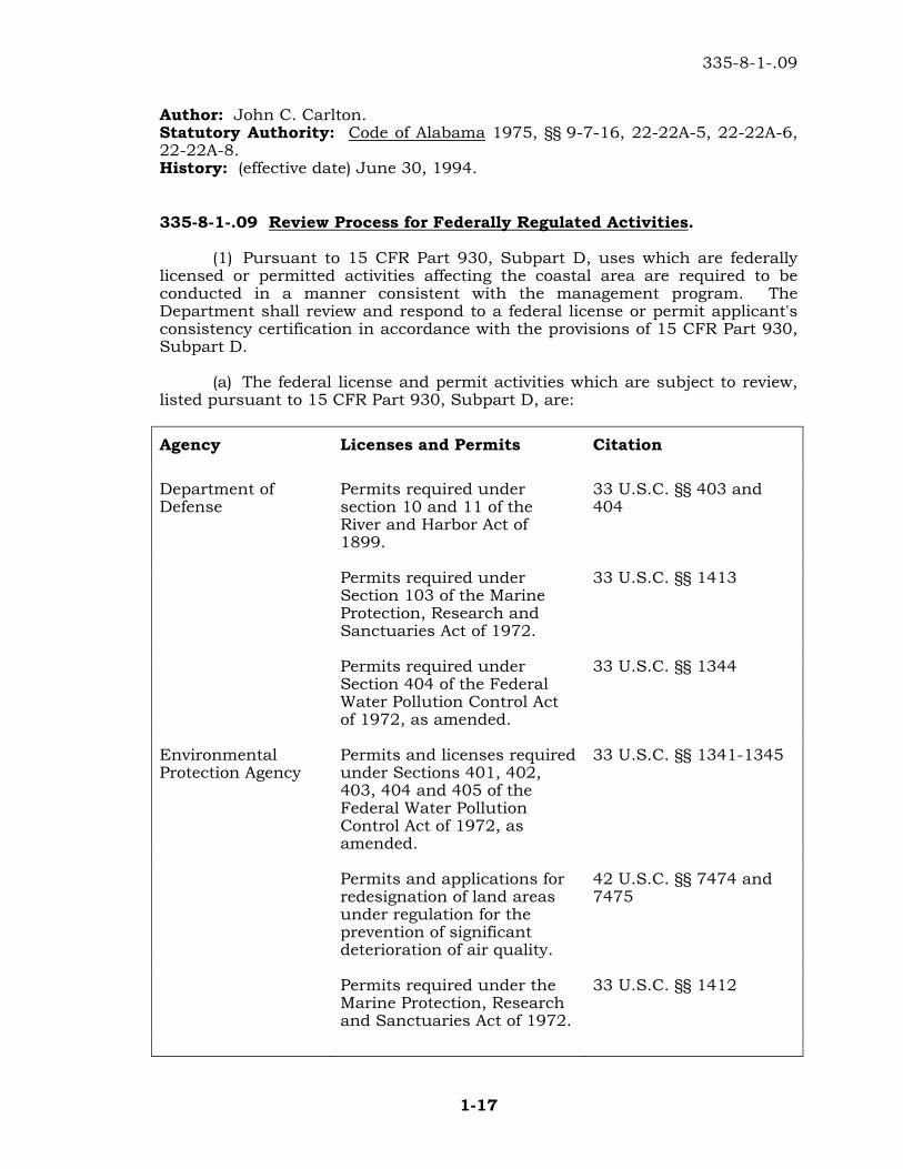
335-8-1-.09 Review Process for Federally Regulated Activities.
(1) Pursuant to 15 CFR Part 930, Subpart D, uses which are federally licensed or permitted activities affecting the coastal area are required to be conducted in a manner consistent with the management program. The Department shall review and respond to a federal license or permit applicant's consistency certification in accordance with the provisions of 15 CFR Part 930, Subpart D. (a) The federal license and permit activities which are subject to review, listed pursuant to 15 CFR Part 930, Subpart D, are:
Agency Licenses and Permits Citation Department of Defense
Permits required under section 10 and 11 of the River and Harbor Act of 1899.
33 U.S.C. §§ 403 and 404
Permits required under
Section 103 of the Marine Protection, Research and Sanctuaries Act of 1972.
33 U.S.C. §§ 1413
Permits required under
Section 404 of the Federal Water Pollution Control Act of 1972, as amended.
33 U.S.C. §§ 1344
Environmental Protection Agency
Permits and licenses required under Sections 401, 402, 403, 404 and 405 of the Federal Water Pollution Control Act of 1972, as amended.
33 U.S.C. §§ 1341-1345
Permits and applications for
redesignation of land areas under regulation for the prevention of significant deterioration of air quality.
42 U.S.C. §§ 7474 and 7475
Permits required under the
Marine Protection, Research and Sanctuaries Act of 1972.
33 U.S.C. §§ 1412
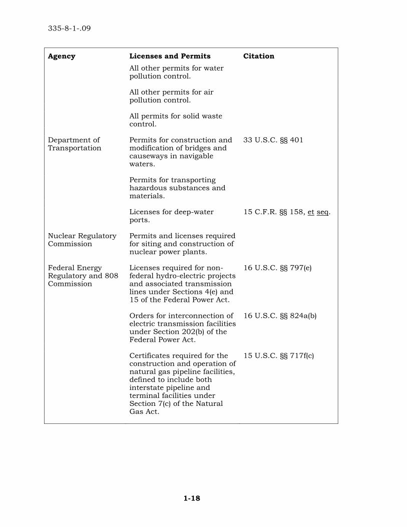
335-8-1-.09
1-18
Agency Licenses and Permits Citation All other permits for water
pollution control.
All other permits for air
pollution control.
All permits for solid waste
control.
Department of Transportation
Permits for construction and modification of bridges and causeways in navigable waters.
33 U.S.C. §§ 401
Permits for transporting hazardous substances and materials.
Licenses for deep-water
ports. 15 C.F.R. §§ 158, et seq.
Nuclear Regulatory Commission
Permits and licenses required for siting and construction of nuclear power plants.
Federal Energy Regulatory and 808 Commission
Licenses required for non-federal hydro-electric projects and associated transmission lines under Sections 4(e) and 15 of the Federal Power Act.
16 U.S.C. §§ 797(e)
Orders for interconnection of
electric transmission facilities under Section 202(b) of the Federal Power Act.
16 U.S.C. §§ 824a(b)
Certificates required for the
construction and operation of natural gas pipeline facilities, defined to include both interstate pipeline and terminal facilities under Section 7(c) of the Natural Gas Act.
15 U.S.C. §§ 717f(c)

335-8-1-.09
1-19
Agency Licenses and Permits Citation Permission and approval
required for the abandonment of natural gas pipeline facilities under Section 7(b) of the Natural Gas Act.
15 U.S.C. §§ 717f(b)
Department of the Interior
Permits and licenses required for all offshore activities related to mining and oil and gas operations.
33 U.S.C. §§ 181, et seq.
Permits for the taking of an
endangered species Endangered Species Act 16 U.S.C. §§ 1531-1543
Permits and licenses required for geothermal operations.
Geothermal Steam Act of 1970.
Department of Agriculture
Permits for water easements and timbering activities on National U.S. Forest Service land.
43 U.S.C. §§ 1716.
Permits and licenses for use
and occupancy of lands for hotels, resorts, summer homes, stores and facilities for industrial, commercial, educational or public use.
16 U.S.C. §§ 497
Department of Energy
Permits for the construction, operation, siting of energy facilities.
Department of Commerce
Permits for research involving taking endangered species or marine mammals or for taking of marine mammals for public; display or incidental to commercial fishing.
Endangered Species Act of 1973; 16 U.S.C. §§ 1531-1543 Marine Mammal Protection Act16 U.S.C. §§ 1361-1407.
(b) In addition to the data and information required to be furnished to the Department with the consistency certification pursuant to 15 C.F.R. §§ 930.58, the following data and information must be provided: 1. An informational copy of the application for the license or permit; 2. A copy of the federal agency's written determination that the license or permit application is complete;
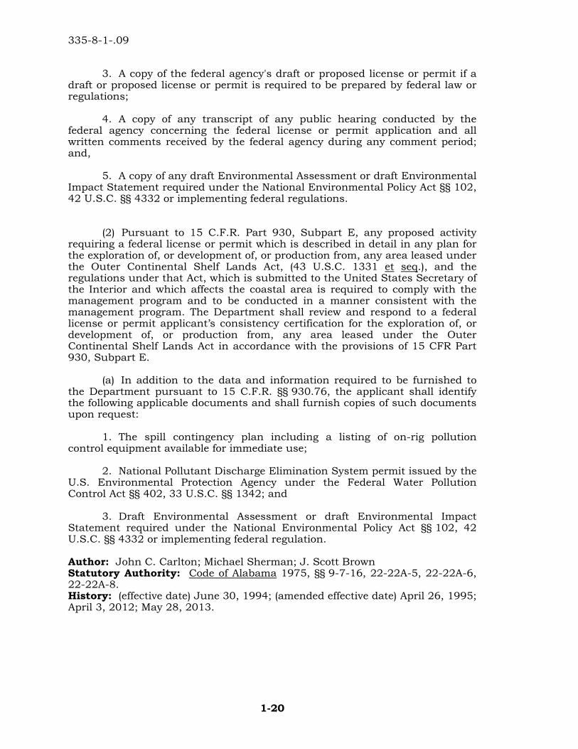
335-8-1-.09
1-20
3. A copy of the federal agency's draft or proposed license or permit if a draft or proposed license or permit is required to be prepared by federal law or regulations; 4. A copy of any transcript of any public hearing conducted by the federal agency concerning the federal license or permit application and all written comments received by the federal agency during any comment period; and, 5. A copy of any draft Environmental Assessment or draft Environmental Impact Statement required under the National Environmental Policy Act §§ 102, 42 U.S.C. §§ 4332 or implementing federal regulations. (2) Pursuant to 15 C.F.R. Part 930, Subpart E, any proposed activity requiring a federal license or permit which is described in detail in any plan for the exploration of, or development of, or production from, any area leased under the Outer Continental Shelf Lands Act, (43 U.S.C. 1331 et seq.), and the regulations under that Act, which is submitted to the United States Secretary of the Interior and which affects the coastal area is required to comply with the management program and to be conducted in a manner consistent with the management program. The Department shall review and respond to a federal license or permit applicant’s consistency certification for the exploration of, or development of, or production from, any area leased under the Outer Continental Shelf Lands Act in accordance with the provisions of 15 CFR Part 930, Subpart E. (a) In addition to the data and information required to be furnished to the Department pursuant to 15 C.F.R. §§ 930.76, the applicant shall identify the following applicable documents and shall furnish copies of such documents upon request: 1. The spill contingency plan including a listing of on-rig pollution control equipment available for immediate use; 2. National Pollutant Discharge Elimination System permit issued by the U.S. Environmental Protection Agency under the Federal Water Pollution Control Act §§ 402, 33 U.S.C. §§ 1342; and 3. Draft Environmental Assessment or draft Environmental Impact Statement required under the National Environmental Policy Act §§ 102, 42 U.S.C. §§ 4332 or implementing federal regulation.
Author: John C. Carlton; Michael Sherman; J. Scott Brown Statutory Authority: Code of Alabama 1975, §§ 9-7-16, 22-22A-5, 22-22A-6, 22-22A-8. History: (effective date) June 30, 1994; (amended effective date) April 26, 1995; April 3, 2012; May 28, 2013.
335-8-1-.10
1-21
335-8-1-.10 Review Process for Federal Projects, Activities and Assistance.
(1) Pursuant to 15 C.F.R. Part 930, Subpart C, functions performed by or on behalf of a federal agency in the exercise of its statutory responsibilities and development projects undertaken by or on behalf of the federal agency involving the planning, construction, modification, or removal of public works, facilities, or other structures, in the acquisition, utilization, or disposal of land or water resources which affect the coastal area are required to be undertaken in a manner consistent, to the maximum extent practicable, with the management program. The Department shall review and respond to federal agency consistency determinations in accordance with the provisions of 15 C.F.R. Part 930, Subpart C. (a) Federal activities which are subject to review, and are listed pursuant to 15 C.F.R. Part 930, Subpart C, include, but are not limited to, the following: 1. Property acquisition or disposal within the coastal area; 2. Discharge of wastes into the air or waters of the coastal area; 3. Road construction within the coastal area; 4. Disposition, design, construction, alteration or maintenance of any facilities on lands located within the coastal area; 5. Programs related to management of coastal resources; 6. Activities affecting water quality or quantity; 7. Transport of hazardous substances; and 8. Other activities that could affect coastal resources due to their size, location, or manner of construction. (2) Pursuant to 15 C.F.R. Part 930, Subpart F, assistance provided under a federal program to any unit of state or local government, or any related public entity such as a special purpose district, through grant or contractual arrangements, loans, subsidies, guarantees, insurance, or other form of financial aid for activities affecting the coastal area, are required to be consistent with the management program. The Department shall review and respond to applications from applicant agencies for federal assistance in accordance with the provisions of 15 C.F.R. Part 930, Subpart F. (a) The types of federal assistance programs subject to review, and listed pursuant to 15 C.F.R. §§ 930.95 include, but are not limited to, the following: 1. Grants or loans by the U.S. Department of Agriculture, Farmers Home Administration; 2. Housing development grants by the U.S. Department of Housing and Urban Development;
335-8-1-.11
1-22
3. Grants by the U.S. Department of Transportation, Federal Aviation Administration; 4. Grants or loans from the Land and Water Construction Fund by the U.S. Department of the Interior; 5. Grants or loans by the U.S. Department of Commerce for public works and development; 6. Community development block grants by the U.S. Department of Housing and Urban Development; 7. Sewage treatment construction grants or loans made directly by capitalization grants from the U.S. Environmental Protection Agency; and 8. Urban development actions grants by the U.S. Department of Housing and Urban Development. Author: John C. Carlton; Michael Sherman. Statutory Authority: Code of Alabama 1975, §§ 9-7-16, 22-22A-5, 22-22A-6, 22-22A-8. History: (effective date) June 30, 1994; April 3, 2012.
335-8-1-.11 Review Process for Non-Regulated Uses.
(1) Any person wishing to conduct a non-regulated use in the coastal area must make an application to the Department for a Department permit. (2) The review procedure is initiated by submission of a completed application form supplied by the Department. Upon receipt of the application, the Department will begin its review process, will inform the permit applicant of any additional information and studies which will be required, and will give notice to the applicant of the availability of a public hearing upon request. (3) If the Department finds during the course of its review that the use is not subject to the management program, it will so notify the applicant, and the review process will be terminated. (4) Following receipt of the complete application and any additional information requested and upon completion of the Department's review, the Department shall do one of the following: (a) Issue a permit for the use with or without conditions; or (b) Deny the permit.
Author: John C. Carlton. Statutory Authority: Code of Alabama 1975, §§ 9-7-16, 22-22A-5, 22-22A-6, 22-22A-8. History: (effective date) June 30, 1994; (amended effective date) April 26, 1995.
335-8-1-.12
1-23
335-8-1-.12 Review Process for Local Program Delegation.
(1) Any local government issuing licenses or permits for uses which are subject to the management program may apply to the Department for local program delegation. (2) Application for delegation shall be in the form of a written request by the chief executive officer of the local government and include: (a) an indication of the specific regulation(s) of this Administrative Code for which delegation is sought; (b) a copy of all existing or draft proposed local codes and a description of the local permitting procedures for uses subject to the regulations for which delegation is sought; and (c) other such information as the Department may require. (3) Upon receipt of a properly filed and complete request for local program delegation, the Department will begin its review process and initiate interagency coordination with the local government. (4) In order for program delegation to be effected, the applicant shall demonstrate to the satisfaction of the Department that: (a) the local codes are adequate to ensure that uses permitted and undertaken pursuant to the local program will be in compliance with the management program and consistent with the requirements of this Administrative Code; (b) the local codes provide a right of appeal for a person aggrieved by a local government permit decision; (c) the local codes contain provisions for granting a variance from requirements of the local permitting program in cases where the application of the requirement(s) would be unduly restrictive or constitute a taking of property without payment of full compensation in accordance with the Constitution of the State of Alabama or of the United States; and (d) the local codes will be enforced and the local permitting program will be implemented as approved. (5) If a determination is made not to approve a local permitting program the Department will so notify the applicant of the decision and provide the reasons and supporting details for the disapproval. (6) Department approval of a local permitting program remains valid for a period of five years or until any one of the following occurs: (a) the Department determines that the local codes are not enforced as approved;
335-8-1-.13
1-24
(b) the Department determines that the local permitting program is not being implemented as approved; (c) the Department determines that the local code or the local permitting program is no longer in compliance with the management program. (7) To remain valid, approved local codes and local permitting programs shall be resubmitted for Departmental approval five years after the last date of approval. (a) Resubmittals shall follow, and be subject to, the provisions set forth in ADEM Administrative Code 335-8-1-.12(2). (b) Unless otherwise notified by the Department, the local government may continue to enforce the local codes and implement the local permitting program during the Department's review of the resubmission. (8) The chief executive officer of the local government having local program delegation shall submit to the Department any proposed amendment to an approved local code or local permitting program or any proposed expansion of the local government jurisdictional boundaries for review and approval by the Department prior to adoption. (9) Upon approval of local program delegation, the local government is authorized to issue a license or permit to conduct those uses specified in the Department's approval of the local codes and local permitting program, said uses not being subject to further permitting requirements of the Department except as may be set forth in this Administrative Code. Author: John C. Carlton. Statutory Authority: Code of Alabama 1975, §§ 9-7-16, 22-22A-5, 22-22A-6, 22-22A-8. History: (effective date) June 30, 1994; (amended effective date) April 26, 1995.
335-8-1-.13 Variances.
(1) The Department may grant a variance from any requirement of this Administrative Code where the applicant therefore has demonstrated to the satisfaction of the Department that application of the requirement would be unduly restrictive or constitute a taking of property without payment of full compensation in accordance with the Constitution of the State of Alabama or of the United States. Any variance granted pursuant to this Rule may impose conditions and requirements to effectuate to the maximum extent the object of the rule for which a variance is sought without being unduly restrictive or constituting a taking of property without payment of full compensation in accordance with the Constitution of the State of Alabama or of the United States. (2) An application for a variance pursuant to this rule shall contain, at a minimum, the following information:
335-8-1-.14
1-25
(a) a completed application form and any information required for the type of use for which the variance is being sought; (b) a certified letter indicating specifically from which regulation(s) a variance is sought; (c) a legal argument and documentation which demonstrates that failure by the Department to grant a variance would constitute a taking of property without just compensation; (d) a certified copy of the deed or other instrument under which the applicant claims title or possession of the property upon which the project will be carried out; (e) a demonstration that the project has been planned so as to minimize impacts on the coastal area for which the regulation, from which a variance is sought, was adopted and a demonstration that no alternative sites or means to accomplish the desired activity are available; and (f) other information as the Department may require. Author: John C. Carlton. Statutory Authority: Code of Alabama 1975, §§ 9-7-16, 22-22A-5, 22-22A-6, 22-22A-8. History: October 9, 1985, amended (effective date) June 30, 1994.
335-8-1-.14 Public Notice and Hearings.
(1) Prior to the Department issuing a decision on the issuance, modification, or denial of any permit or variance under this administrative code, or on the concurrence with or objection to a certificate of consistency for a use requiring a federal permit or license (including any use described in a plan for the exploration or development of, or production from any area leased under the Outer Continental Shelf Lands Act) or on the approval or disapproval of a local permitting program, or on the issuance, modification, or denial of a certificate of compliance for a use requiring a state permit, the Department or its agents (including other state or federal agencies) shall issue a public notice of the proposed activity for the purpose of soliciting public comment thereon or shall require the applicant for the Department permit or variance or federal permit or license to provide such notice in a manner prescribed by the Department. Said notice shall be issued at least fifteen (15) days prior to issuance of the Department's decision. (2) The Department may provide an opportunity for a public hearing on the proposed activity if any person has satisfactorily demonstrated that a relevant and significant issue cannot be effectively or fully communicated to the Department in writing or a significant public interest would be served thereby. Any public hearing provided shall be announced at least thirty days prior to the hearing date.
335-8-1-.14
1-26
(3) The Department will provide post notice of final determinations made on permit or variance applications to those individuals who properly request such notice in writing to the Department during the public comment period. (4) Public notice may not be required for modifications, and permit extensions or renewals in which the impact is expected to be equal to or less than that originally permitted. All editorial changes and permit name changes shall not be subject to the public notice requirements of this rule. Author: John C. Carlton. Statutory Authority: Code of Alabama 1975, §§ 9-7-16, 22-22A-5, 22-22A-6, 22-22A-8. History: (effective date) June 30, 1994.
2-1
ALABAMA DEPARTMENT OF ENVIRONMENTAL MANAGEMENT COASTAL AREA MANAGEMENT PROGRAM
CHAPTER 335-8-2
PROVISIONS RELATED TO COASTAL ACTIVITIES
TABLE OF CONTENTS
335-8-2-.01 General Rules Applicable to All Uses Subject to the ACAMP 335-8-2-.02 Dredging and/or Filling 335-8-2-.03 Mitigation 335-8-2-.04 Marinas 335-8-2-.05 Piers, Docks, and Boathouses 335-8-2-.06 Shoreline Stabilization and Erosion Mitigation 335-8-2-.07 Canals, Ditches, and Boatslips 335-8-2-.08 Construction and Other Activities on Gulf Beaches and Dunes 335-8-2-.09 Groundwater Extraction 335-8-2-.10 Siting, Construction and Operation of Energy Facilities 335-8-2-.11 Commercial and Residential Development 335-8-2-.12 Discharges to Coastal Waters
335-8-2-.01 General Rules Applicable to All Uses Subject to the Alabama Coastal Area Management Plan (ACAMP).
(1) Uses that are determined by the Department to be in violation of applicable air or water quality standards or associated regulations shall not be permitted or certified to be in compliance with the ACAMP. (2) In determining a uses ability to comply with this Administrative Code, the Department shall consider the extent to which the use adversely impacts the following coastal resources: (a) Historical, architectural or archaeological sites designated pursuant to 16 U.S.C. §§ 470-470W; (b) Wildlife and fishery habitat especially the designated Critical Habitats of endangered species listed pursuant to 16 U.S.C. §§1531-1543; (c) Public access to tidal and submerged lands, navigable waters and beaches or other public recreational resources. (3) Any person shall notify the Department and the State Historical Officer of any historical, cultural or archaeological resources that are discovered in the course of conducting an authorized activity. (4) Uses that are determined by the Department to be inconsistent with a designated special management area shall not be permitted or certified to be in compliance with the ACAMP.
335-8-2-.02
2-2
(5) All projects must comply with all applicable provisions of this Administrative Code. Author: John C. Carlton. Statutory Authority: Code of Alabama 1975, §§ 9-7-16, 22-22A-5, 22-22A-6, 22-22A-8. History: (effective date) June 30, 1994; (amended effective date) April 26, 1995.
335-8-2-.02 Dredging and/or Filling.
(1) Dredging and/or filling of State waterbottoms or adjacent wetlands may be permitted or certified to be in compliance with the ACAMP provided that: (a) the activity is related to an existing or approved water dependent use, or use of regional benefit or related to an approved beach nourishment, shoreline stabilization or marsh creation, restoration or enhancement project, elimination of dead-end canals or boatslips exhibiting poor water quality or other similar beneficial use; (b) there will be no dredging or filling in close proximity to existing natural oyster reefs, as defined pursuant to Code of Alabama 1975, §§ 9-12-21, except in association with the approved creation or enhancement of oyster reefs or artificial fish attracting structures; (c) there will be no dredging or filling in close proximity to existing submersed grassbeds; (d) dredging, filling or trenching methods and techniques are such that reasonable assurance is provided that applicable water quality standards will be met; and no alternative project site or design is feasible and the adverse impacts to coastal resources have been reduced to the greatest extent practicable. (2) Dredging, filling, or trenching resulting in a temporary disturbance may be permitted or certified to be in compliance with the ACAMP provided that all areas are returned to preproject elevations and all wetland areas are revegetated and the requirements set forth in §335-8-2-.02(1)(b) thru (d) are met. (3) Dredging or filling of non-adjacent wetlands may be permitted or certified to be in compliance with the ACAMP provided that: (a) no alternative project sites or designs which avoid the dredging or filling are feasible and the adverse impacts have been reduced to the greatest extent possible; and
(b) the Department determines, on a site specific basis, that the non-adjacent wetlands to be dredged or filled have a limited functional value. (4) For projects impacting wetlands, the applicant mitigates for wetland impacts in accordance with the provisions of 335-8-2-.03, unless the Department determines that, due to the scope and nature of the project,
335-8-2-.03
2-3
mitigation is unnecessary or the project is subject to the provisions of 335-8-1-.03(4). (5) Any fill material placed on State water bottoms or in wetlands shall be free of toxic pollutants in toxic amounts and shall be devoid of sludge and/or solid waste. (6) Dredge material shall not be placed in wetlands unless specifically permitted or authorized by the Department. (7) The disposal of dredge material into open state waters may be permitted or certified to be in compliance with the ACAMP, provided that it complies with the relevant provisions of this Administrative Code. (8) The salinity of return waters from dredge disposal sites shall be similar to that of the receiving waters and reasonable assurance provided that applicable water quality standards will be met. Author: John C. Carlton. Statutory Authority: Code of Alabama 1975, §§ 9-7-16, 22-22A-5, 22-22A-6, 22-22A-8. History: (effective date) June 30, 1994; (amended effective date) November 1, 1994; (amended effective date) April 26, 1995.
335-8-2-.03 Mitigation.
(1) Mitigation for wetland impacts resulting from an approved project shall involve the creation of wetlands or the restoration and enhancement of existing degraded wetlands. (2) Prior to permitting or certification of a use for which mitigation is required, the applicant shall submit to the Department for review and approval a mitigation plan which shall include but not be limited to the following: (a) a survey of the proposed mitigation site which shall include a delineation of existing vegetative cover, the location of all drainage ways and water courses, and property location, size and description; (b) an indication of site preparation techniques which shall include initial and final elevations, planting and fertilization schedules, plant spacing, and source and vegetative species to be planted; (c) documentation that, by instrument of law, the mitigation site will be set aside and protected; and (d) a monitoring, maintenance and reporting schedule which covers the first five years of mitigation.
335-8-2-.04
2-4
Author: John C. Carlton. Statutory Authority: Code of Alabama 1975, §§ 9-7-16, 22-22A-5, 22-22A-6, 22-22A-8. History: (effective date) June 30, 1994.
335-8-2-.04 Marinas.
(1) Applicants desiring to construct and operate a new or expand an existing marina within the coastal area must provide: (a) a comprehensive site plan showing location, size, and number of all upland and water-dependent facilities including boatslips, parking, storage facilities, maintenance and repair facilities, and pile-supported structures; (b) an "Operation and Maintenance Plan" describing the manner in which the facility will be operated, to include the use of best management practices and a demonstration that: 1. applicable water quality standards will be maintained; 2. applicable measures relating to proper disposal of solid waste, litter, fish carcasses and offal, and other refuse are provided; and 3. adequate sewage pump out and disposal facilities will be provided for vessels and adequate restrooms for patrons will be provided; (c) if applicable, a spill prevention control and countermeasure plan meeting the requirement of 40 CFR Part 112; (d) if applicable, an application for a stormwater permit, or if such permit has already been obtained, a copy of the same; and (e) a submerged lands lease or waiver from the Alabama Department of Conservation and Natural Resources. (2) Marinas shall not be located within, or in close proximity to, submersed grassbeds or existing public oyster reefs. (3) Open water marinas constructed in the coastal area shall not have breakwaters, groins, or jetties which significantly interfere with the normal ebb and flow of coastal waters. (4) Proposals involving excavated marinas shall include appropriate analyses and demonstrations that the facility will not result in contravention of water quality standards in the adjoining waters. (5) Entrance channels and boat basins shall be constructed to a depth no greater than that of the receiving water.
335-8-2-.06
2-5
Author: John C. Carlton. Statutory Authority: Code of Alabama 1975, §§ 9-7-16, 22-22A-5, 22-22A-6, 22-22A-8. History: (effective date) June 30, 1994.
335-8-2-.05 Piers, Docks, Boathouses, and Other Pile Supported Structures.
(1) Piers, docks, boathouses, and other pile supported structures shall be constructed on pilings that permit a reasonable unobstructed ebb and flow of the tide. (2) Platforms, decks, "T's", "L's", boathouses, and other similar minor structures associated with residential piers and docks should be located at the waterward end of the pier or dock and shall not be constructed over wetlands or submersed grassbeds nor shall they be habitable. (3) Piers and docks shall be of sufficient length to reach navigational depths adequate for the proposed use of the pier or dock, to the extent that a hazard to navigation will not be created as determined by the U.S. Coast Guard. (4) Piers, docks, boathouses, and other pile supported structures shall be designed and constructed such that impacts to wetlands and submersed grassbeds are minimized. Author: John C. Carlton. Statutory Authority: Code of Alabama 1975, §§ 9-7-16, 22-22A-5, 22-22A-6, 22-22A-8. History: (effective date) June 30, 1994; (amended effective date) April 26, 1995.
335-8-2-.06 Shoreline Stabilization and Erosion Mitigation.
(1) Bulkheads, the placement of rip-rap, and other structural shoreline armament shall not be permitted or certified to be in compliance with the ACAMP unless it is demonstrated to the satisfaction of the Department that: (a) no fill material will be placed in wetlands or submersed grassbeds unless specifically authorized pursuant to 335-8-2-.02; (b) the structure will be placed at or above mean high tide and landward of any wetlands; (c) the structure will be designed so as to allow the normal hydrologic regime to be maintained in wetland areas; and (d) there are no feasible non-structural alternatives available including, but not limited to, preservation and restoration of dunes, beaches, wetlands, submersed grassbeds, and shoreline restoration and nourishment and retreat or abandonment.
335-8-2-.08
2-6
(2) Jetties, groins, breakwaters and like structures may be permitted or certified to be in compliance with the ACAMP provided it is demonstrated to the satisfaction of the Department that: (a) they are necessary to protect an existing navigational channel or a use of regional benefit; (b) there are no other feasible non-structural alternatives; and (c) there are no significant impacts to adjacent shorelines. Author: John C. Carlton. Statutory Authority: Code of Alabama 1975, §§ 9-7-16, 22-22A-5, 22-22A-6, 22-22A-8. History: (effective date) June 30, 1994; (amended effective date) April 26, 1995.
335-8-2-.07 Canals, Ditches, and Boatslips.
(1) Canals constructed for the purposes of providing navigable access to an existing or approved water dependent facility or Use of Regional Benefit may be permitted or certified to be in compliance with the ACAMP. (2) Construction of new canals or expansions of existing canals through wetlands or uplands with the purpose or effect of creating new waterfront property, shall not be permitted or certified to be in compliance with the ACAMP. (3) Stormwater drainage ditches may be permitted or certified to be in compliance with the ACAMP provided that the applicant demonstrates to the satisfaction of the Department that they are hydrologically designed and constructed such that a positive stormwater flow results, and standing water is minimized. (4) Excavated boatslips may be permitted or certified to be in compliance with the ACAMP only in areas where it is demonstrated that the construction of a pier and dock will obstruct navigation. Author: John C. Carlton. Statutory Authority: Code of Alabama 1975, §§ 9-7-16, 22-22A-5, 22-22A-6, 22-22A-8. History: (effective date) June 30, 1994.
335-8-2-.08 Construction and Other Activities on Gulf Front Beaches and Dunes.
(1) No person shall remove primary dune or beach sands and/or vegetation or otherwise alter the primary dune system, construct any new structure, or make any substantial improvement to any existing structure, on, beneath or above the surface of any land located between mean high tide and the construction control line.
335-8-2-.08
2-7
(2) No person shall construct any new structure on, beneath or above the surface of any state owned lands located in the following areas: (a) between mean high tide and a line originating at plane coordinate (x = 339,562.58 feet; y = 83,758.99 feet) and extending South 77° 59' 16" West in Baldwin County; (b) between mean high tide and Alabama Highway 180 between plane abscissas (x = 339,562.58 feet) and (x = 343,833.777 feet); (c) in Sections 2 and 3 of Township 4 South, Range 33 West (Tallahassee Meridian) in Baldwin County. No person shall construct any new structure on, beneath or above any lands located between the westernmost end of Dauphin Island and a north-south plane represented by the abscissa (x = 281,573.2 feet) in Mobile County.
(3)(a) No person shall construct any new structure or make any substantial improvement to an existing structure, on, beneath or above the surface of any parcel of land owned by a person if any portion of such parcel is intersected by the construction control line without first having obtained a permit therefor from the Department except as maybe provided for by 335-8-1-.05. (b) A permit for construction of a new structure may be issued if the Department is satisfied that the proposed structure is not on, beneath or above the surface of any lands located between mean high tide and the construction control line. (c) An application for a permit to construct a single family dwelling or duplex pursuant to this rule shall contain: 1. a legal description of the property on which the structure is proposed, as well as the street address;
2. an area map showing the location of the property and proposed structure in relation to roads and other recognized landmarks; 3. a survey of the property and site plan prepared by a duly licensed land surveyor of the State of Alabama showing the location of the construction control line, as determined from the state plane coordinates, the distance from the nearest construction control line monument to the lot, and the location and dimensions of all proposed structures; 4. a certified copy of the deed, lease or other instrument under which the applicant claims title, possession or permission from the owner of the property to carry out the project; 5. an identification of the water supply source and wastewater disposal system; 6. such other information as the Department may reasonably require to assure compliance with the Department's rules and regulations.
335-8-2-.08
2-8
(d) An application for a permit to construct a motel, hotel, condominium, or planned multi-unit development shall contain: 1. all information required by 335-8-2-.08(3)(c); 2. an "Environmental Impact and Natural Hazards Study" which will include, at a minimum, the following: (i) wave height study addressing the flood hazard and erosion potential at the project site using eroded beach profiles for pre and post developed conditions; (ii) location and delineation of velocity zone; and (iii) analysis of the project's potential to significantly increase the likelihood that damage will occur from floods, hurricanes, or storms. 3. a "Beach and Dune Enhancement Plan" which includes, at a minimum, the following: (i) fence placed along the CCL prior to and during construction activities to prevent material and equipment seaward of the line; (ii) dune walkovers designed to accommodate the anticipated pedestrian traffic from the completed project; (iii) the placement of sand fences; (iv) planting of suitable natural vegetation in areas devoid of vegetation; and (v) a maintenance program for the sand fences and plantings. (4) Bulkheads, retaining walls, or similar structures shall not be permissible on Gulf beaches or primary dunes unless it can be demonstrated that: (a) the bulkhead or retaining wall is landward of the CCL and it is necessary to protect and insure the structural integrity of an existing or previously permitted structure; and (b) there are no other feasible non-structural alternatives, including retreat. (5) No person shall operate a motorized vehicle on the beach or primary dune system, except as may be provided by the provisions of this Administrative Code. (6) Beach cleaning equipment and safety and law enforcement vehicles operating on flat beach sand may be permissible, provided it is demonstrated to the satisfaction of the Department that: (a) the equipment will not be operated within the primary dune system;
335-8-2-.09
2-9
(b) a route of ingress and egress has been designated and approved by the Department or its Contractor; (c) beach and dune vegetation will not be impacted or destroyed; and (d) the equipment will be operated only in areas specified by the Department or its contractor. (7) Septic tanks and other on-site sewage disposal systems shall not be permitted on a lot intersected by the construction control line, unless no wastewater disposal system is available for the site and the system has been approved by the Department of Public Health. (8) The Department has determined that the following activities conducted seaward of the construction control line are not subject to the ACAMP: the placement of items associated with daily recreational use that are of a temporary and removable nature, including but not limited to, chairs, umbrellas, volleyball and similar equipment, provided the posts are not permanently installed in the ground, and provided these items are removed from the beach prior to major storm events. Author: John C. Carlton. Statutory Authority: Code of Alabama 1975, §§ 9-7-16, 22-22A-5, 22-22A-6, 22-22A-8. History: August 14, 1979; amended October 10, 1984, October 9, 1985, October 7, 1988, (effective date) June 30, 1994; (amended effective date) April 26, 1995.
335-8-2-.09 Groundwater Extraction.
(1) Installation of a new well, or alteration of an existing well, for the purposes of extracting groundwater at a rate of 50 gallons per minute or greater requires a permit from the Department. This provision is applicable to a well whose surface location is in the coastal area and one whose surface location is not in the coastal area but whose 50 year capture zone extends into the coastal area. (a) An application for a permit to construct and operate a well which is subject to these provisions shall include: 1. a detailed plan for drilling, sampling, and testing the well; 2. results of analyses which provide the predicted 50 year capture zone of the proposed well at maximum designed pumping capacity; 3. the identification of existing wells, which are capable of pumping 50 gallons per minute or more, and their respective 50 year capture zones, which are located within one mile of the proposed well's 50 year capture zone; and 4. reasonable assurance by the applicant that the proposed activity will not impact groundwater.
335-8-2-.09
2-10
(b) The applicant may proceed to install and test the well unless the Department objects in writing within 30 days after receipt of a complete application; however, the lack of an objection by the Department should not be construed as obligating the Department to issue a permit to operate. (2) Wells shall be drilled and sampled using specialized techniques designed to determine if saltwater zones overlie the target production zone, and shall be logged by a qualified geologist in sufficient detail to establish permeable and impermeable zones and their associated quality. (a) After the well is constructed, it shall be pump tested to establish aquifer characteristics of transmissivity and storage coefficient using an observation well which is located an appropriate distance from the pumping well and screened in the production zone of the pumping well. 1. The distance from the observation well to the production well shall be equal to or greater than the value derived by the following equation: 1.5M (PH/PV)0.5 Where M = aquifer thickness in feet PH = aquifer horizontal conductivity in gallons per day per sq. ft. PV = aquifer vertical conductivity in gallons per day per sq. ft. 2. The pump test shall be of sufficient duration to establish aquifer characteristics and groundwater quality. The duration shall be sufficient for the water level to stabilize at design capacity of the well, but in no case shall the duration be less than 12 hours. An evaluation of the pump test data and water quality analysis shall be submitted to the Department for review. (3) Water samples taken for analysis shall be obtained in accordance with the ADEM Field Operations Standard Operating Procedures or other methods approved by the Department. Parameter coverage shall be specified by the Department. (4) If the Department determines that saltwater intrusion should be evaluated, a monitoring well may be required to be placed at the 50 year capture zone perimeter in the direction of the most likely source of vertical or horizontal saltwater intrusion into the production aquifer. (5) Based upon all available information, if it is demonstrated to the satisfaction of the Department that the normal operation of the well will not adversely impact the existing quality of groundwater, a permit to operate the well may be issued. (6) The Department may deny a permit if the operation of a new or altered well would adversely impact existing drinking water wells.
335-8-2-.10
2-11
Author: John C. Carlton. Statutory Authority: Code of Alabama 1975, §§ 9-7-16, 22-22A-5, 22-22A-6, 22-22A-8. History: (effective date) June 30, 1994; (amended effective date) April 26, 1995.
335-8-2-.10 Siting, Construction and Operation of Energy Facilities.
(1) All new energy facilities located wholly or partially within the coastal area and which require a federal license or permit or a state agency permit must also receive coastal consistency from the Department prior to any land clearing or construction. In addition to the information provided to the federal and state permitting agencies, the following supplemental information shall be provided to the Department: (a) a survey of the property, encompassing the entire project, prepared by a duly licensed land surveyor of the State of Alabama which shows all property boundaries, existing topographic features, all existing water courses, any and all areas which have been delineated as wetlands, and the proposed location(s) of all improvements and facilities; (b) identification of all environmental permits which may be required for construction; discharges to water; air emissions; hazardous waste generation, transportation, storage and disposal; solid waste disposal; groundwater extraction; etc; and (c) an indication of the potential impacts to the following coastal resources, as applicable:
Water Quality Groundwater Resources Air Quality Cultural Resources Wetlands and Submersed Grassbeds Wildlife Habitat Beaches and Dunes
(2) The siting, construction and operation of energy facilities shall be conducted in a manner which minimizes significant impacts to coastal resources. (3) Discharge of untreated produced waters resulting from energy exploration or production activities to the coastal waters of Alabama shall not be permissible. (4) Discharge of untreated drill muds and/or cuttings to coastal waters shall be permissible only in the Gulf of Mexico, and provided that: (a) the discharge complies fully with the requirements of ADEM Admin. Code R. 335-8-2-.12 even though the discharge may not be continuous; (b) discharges shall not occur within two nautical miles of the shores of gulf beaches; and (c) discharges shall not occur within 3000 meters of another active permitted mud or cuttings discharge.
335-8-2-.11
2-12
(5) Routing of pipelines, cables, and other such energy facility related appurtenances which are buried under or placed upon state waterbottoms shall comply with the provisions of 335-8-2-.02. (6) To the maximum extent possible, pipelines, cables and other such energy facility related appurtenances which are buried under or placed upon state waterbottoms shall be routed through existing pipeline corridors to make landfall. Author: John C. Carlton. Statutory Authority: Code of Alabama 1975, §§ 9-7-16, 22-22A-5, 22-22A-6, 22-22A-8. History: (effective date) June 30, 1994; (amended effective date) April 26, 1995.
335-8-2-.11 Commercial and Residential Development.
(1) All new commercial and residential developments located wholly or partially within the coastal area which are or will be greater than five (5) acres in size and have areas which are or could be delineated as wetlands or are adjacent to coastal waters or are intercepted by the coastal control line shall apply for a permit pursuant to §335-8-1-.11 unless the project requires a federal license or permit pursuant to §335-8-1-.09. In either case, applications shall contain: (a) a survey of the property, encompassing the entire project, prepared by a duly licensed land surveyor of the State of Alabama which shows all property boundaries, existing topographic features, all existing water courses, any and all areas which have been delineated as wetlands, the proposed location of all paved and unpaved roads and other improvements, and proposed platting of individual sub-parcels and lots; (b) identification of the source or supplier of potable water to the development; (c) type of wastewater collection and treatment system(s); (d) an application for a stormwater permit, or if such permit has already been obtained, a copy of the same; and (e) such other information as may be required by the Department. (2) Developments resulting in the platting or subdividing of lots or subparcels on which construction or other reasonable use would not be consistent with the ACAMP shall not be permitted or certified to be in compliance with the ACAMP.
335-8-2-.12
2-13
Author: John C. Carlton. Statutory Authority: Code of Alabama 1975, §§ 9-7-16, 22-22A-5, 22-22A-6, 22-22A-8. History: (effective date) June 30, 1994; (amended effective date) April 26, 1995.
335-8-2-.12 Discharges to Coastal Waters.
(1) Permit applicants for new continuous or frequent discharges to coastal waters which are greater than 1 million gallons per day, or otherwise classified as a major discharge by the Department or EPA Regional Administrator, shall: (a) characterize the sediments and benthic macroinvertebrate community present along the circumferences of two concentric circles, one with a radius of 400 feet and the other with a radius of 800 feet, both having their origin at the proposed discharge point; (b) such characterization shall be completed prior to the initiation of a discharge and shall be repeated if the discharger fails accelerated toxicity testing and is required to initiate a Toxicity Reduction Evaluation (TRE) pursuant to the applicable NPDES permit. 1. Upon notification by the Department the discharger shall repeat the characterization of the sediments and benthic community employing the same sampling locations used in the initial characterization. 2. The Department shall be provided an analysis of the toxicity test and characterization results, to include plans for any necessary corrective action. (2) Existing permitted NPDES dischargers to coastal waters with a continuous or frequent discharge of greater than 1 million gallons per day, or otherwise classified as a major discharge by the Department, shall, upon request for a permit renewal perform a sediment and benthic community characterization as described in paragraph (a) above prior to applying for permit renewal. If a sediment and benthic characterization has been performed in the past then the renewal characterization shall use the same sampling locations as the original characterization and be conducted during the same season. An analysis of the results shall be provided to the Department with the application for renewal. Such characterization shall be repeated if the discharger fails accelerated toxicity testing and is required to initiate a Toxicity Reduction Evaluation (TRE) pursuant to the applicable NPDES permit. (3) If the Department determines that the discharge is resulting in significant adverse impact to the benthic community or sediment quality in an area beyond the boundaries of the original characterization or 400 feet if an original characterization was not performed, the discharger shall be required to submit plans to identify corrective actions which will be taken. (4) The Department may suspend or otherwise modify the monitoring requirements of this rule if:
335-8-2-.12
2-14
(a) the Department determines, through review of discharger information and/or its own monitoring efforts, that the discharge is having no significant impact to coastal resources beyond 400 feet of the discharge point; or (b) the Department determines, through review of discharger information and/or its own monitoring efforts, that the discharge monitoring is inadequate to detect significant impacts to coastal resources beyond 400 feet of the discharge point; or (c) the Department determines, based on available biological and chemical data that, due to the nature of the discharge, no significant impacts to coastal resources will occur beyond 400 feet of the discharge point; or (d) deemed necessary by the Department to ensure the protection of coastal resources. Author: John C. Carlton. Statutory Authority: Code of Alabama 1975, §§ 9-7-16, 22-22A-5, 22-22A-6, 22-22A-8. History: (effective date) June 30, 1994; (amended effective date) April 26, 1995.