Airways New Zealand submission to the Civil Aviation ... · Airways New Zealand submission to the...
22
25 March 2017 CAA 2017 Taranaki Airspace Review - Submission Version 4 Page 1 of 22 Airways New Zealand Airways New Zealand submission to the Civil Aviation Authority's 2017 Taranaki Airspace Review Prepared by: John Wagtendonk Policy, Standards and Safety Improvement Updated version 4 25 March 2017 Below is the Airways submission to the CAA 2017 Taranaki Airspace Review updated to version 3. This submission requests a reduction in the size of the New Plymouth control zone (NP CTR) and significant changes to the New Plymouth control area (NP CTA). Associated with the NP CTA change, the Auckland CTA/D 6500 ft to 9500 ft (NZA438) and the Christchurch CTA/D 6500 ft to 9500 ft (NZA349) would need to be expanded to the west to match the requested expansion of the NP CTA and provide containment of instrument flight procedures. Other AA CTAs above would also need boundary changes to match the expanded NP CTA. The primary driver for the CTR and CTA changes is to contain the planned new PBN IFR arrival, approach and departure procedures at New Plymouth. Those procedures are at an advanced state of design however, some changes may still be needed. Consequently, the submitted draft CTR and CTA may need some alteration due to possible PBN procedure changes. Updated version 2 included addition of CTA step 5500 ft to 6500 ft to the south of New Plymouth. This additional CTA step is required to contain departure procedures to the south that will need to include a requirement to maintain 6000 ft until new waypoint EGMON. Updated version 3 incorporates the following changes; 1. The middle potion of the 6500 ft to 9500 ft CTA to the south of Mt Taranaki has been deleted. The RWY 05 departure track that passed to the south of Mt Taranaki has been moved south to avoid the need for this 6500 ft airspace. 2. Taking into account feedback, the previous draft 4500 ft to 6500 ft CTA to the south east of New Plymouth has been split with the outer portion being raised to 5500 ft lower limit. 3. The outer ring of the previous draft CTA to the north and east has been raised to 5500 ft to be consistent with the raised CTA to the south east. HOWEVER, this raised CTA is only possible if the KYLIE holding pattern is limited to MAX IAS 190 kts and the 2500 ft CTA to the north (over the sea) is extended further north slightly. Updated version 4 incorporates changes to the requested lowering of the CTA above 6500 ft. Request is to lower a portion of NZA149 from 13500 ft to 9500 ft. The draft CTR and CTA are yet to undergo confirmation from Aeropath (the IFR flight procedures designers) that the new PBN procedures will be contained by the draft airspace.
-
Upload
phungkhuong -
Category
Documents
-
view
219 -
download
0
Transcript of Airways New Zealand submission to the Civil Aviation ... · Airways New Zealand submission to the...

25 March 2017 CAA 2017 Taranaki Airspace Review - Submission Version 4 Page 1 of 22 Airways New Zealand
Airways New Zealand submission to the Civil Aviation Authority's
2017 Taranaki Airspace Review
Prepared by: John Wagtendonk Policy, Standards and Safety Improvement
Updated version 4 25 March 2017
Below is the Airways submission to the CAA 2017 Taranaki Airspace Review updated to version 3. This submission requests a reduction in the size of the New Plymouth control zone (NP CTR) and significant changes to the New Plymouth control area (NP CTA). Associated with the NP CTA change, the Auckland CTA/D 6500 ft to 9500 ft (NZA438) and the Christchurch CTA/D 6500 ft to 9500 ft (NZA349) would need to be expanded to the west to match the requested expansion of the NP CTA and provide containment of instrument flight procedures. Other AA CTAs above would also need boundary changes to match the expanded NP CTA. The primary driver for the CTR and CTA changes is to contain the planned new PBN IFR arrival, approach and departure procedures at New Plymouth. Those procedures are at an advanced state of design however, some changes may still be needed. Consequently, the submitted draft CTR and CTA may need some alteration due to possible PBN procedure changes. Updated version 2 included addition of CTA step 5500 ft to 6500 ft to the south of New Plymouth. This additional CTA step is required to contain departure procedures to the south that will need to include a requirement to maintain 6000 ft until new waypoint EGMON.
Updated version 3 incorporates the following changes;
1. The middle potion of the 6500 ft to 9500 ft CTA to the south of Mt Taranaki has been deleted. The RWY 05 departure track that passed to the south of Mt Taranaki has been moved south to avoid the need for this 6500 ft airspace.
2. Taking into account feedback, the previous draft 4500 ft to 6500 ft CTA to the south east of New Plymouth has been split with the outer portion being raised to 5500 ft lower limit.
3. The outer ring of the previous draft CTA to the north and east has been raised to 5500 ft to be consistent with the raised CTA to the south east. HOWEVER, this raised CTA is only possible if the KYLIE holding pattern is limited to MAX IAS 190 kts and the 2500 ft CTA to the north (over the sea) is extended further north slightly.
Updated version 4 incorporates changes to the requested lowering of the CTA above 6500 ft. Request is to lower a portion of NZA149 from 13500 ft to 9500 ft.
The draft CTR and CTA are yet to undergo confirmation from Aeropath (the IFR flight procedures designers) that the new PBN procedures will be contained by the draft airspace.

25 March 2017 CAA 2017 Taranaki Airspace Review - Submission Version 4 Page 2 of 22 Airways New Zealand
DRAFT New Plymouth CTR Proposal
The DRAFT NP CTR proposal as at 3 February 2017 (unchanged with version 3) is depicted in the diagram below. Blue lines are the proposed CTR and the white lines are the existing airspace boundaries to be deleted. A primary reason for reducing the size of the NP CTR is to reclassify as Class G the airspace that is not currently needed for air traffic control purposes or for containment of instrument flight procedures.
Diagram 1 Draft NP CTR
Points to note: 1. The upper limit of the CTR is lowered from existing 2500 ft to 1500 ft. 2. The CTR boundaries are designed to contain the existing VOR/DME approaches based on the aircraft flying a continuous descent profile, including during the base turn, of not shallower than 300 ft per NM to runway threshold/elevation. This is based on AIPNZ ENR 1.5 – 2 para 1.3.3 3. The expanded northern boundary of the draft CTR contains the right-turning VOR/DME RWY 23 missed approach track based on a 300 ft per NM gradient from the VOR at 450 ft MDA. This is based on AIPNZ ENR 1.5 – 2 para 1.3.9. A 2.5 NM buffer from the nominal missed approach track is applied.

25 March 2017 CAA 2017 Taranaki Airspace Review - Submission Version 4 Page 3 of 22 Airways New Zealand
4. The CTR provides containment for Cat A and B circling. In accordance with airspace design policy, containment of Cat C circling is not necessary as straight-in approaches are available. However, for other design reasons, the Cat C circling area to the north of NP is contained (but not to the south). If this draft CTR does get designated then an appropriate notation should be made on approach charts regarding lack of Cat C circling protection to the south of New Plymouth. 5. As well as new PBN straight ahead SIDs, the draft CTR provides for containment of PBN SIDs that turn north/seaward by 30 degrees after take off. A 2 NM buffer is provided between the draft CTR boundary and the nominal track of the RNAV departures to the point where the departure passes 2,000 ft climbing at 300 ft per NM. 6. The draft CTR provides for containment of departures utilising the evaluated climb sector chart (AIPNZ NZNP AD 2 – 62.1) provided that the chart/departure is amended to specify “minimum turn altitude 1100 ft” (Current requirement is minimum turn altitude 500 ft) 7. Airspace containment for the NP VOR RWY 05 and NP VOR RWY 23 approaches (the non-DME approaches) is not assured. Most of the approach would be within the draft CTR and CTA but portions of the approach may not be depending on how far outbound the aircraft tracks. It is suggested that the approaches are annotated along the lines of “Airspace containment not assured for base turn.”

25 March 2017 CAA 2017 Taranaki Airspace Review - Submission Version 4 Page 4 of 22 Airways New Zealand
DRAFT New Plymouth CTA Proposal version 3 Below is the Airways proposed new NP CTA draft as at 17 March 2017. Red lines are the proposed CTA boundaries and the white lines are the existing airspace boundaries to be deleted.
Diagram 2 Draft NP CTA version 3
The above is still a draft and subject to change if there are any needed changes to the planned PBN procedures.

25 March 2017 CAA 2017 Taranaki Airspace Review - Submission Version 4 Page 5 of 22 Airways New Zealand
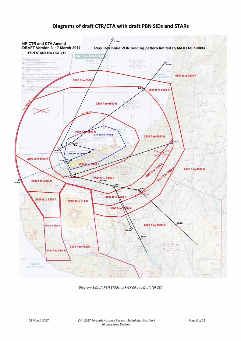
Points to note: 1. The CTA boundaries are designed to contain the planned new NP PBN SIDs and STARs that are being developed. A minimum of 2 NM buffer between the nominal track of the SID/STAR and the CTA boundary is applied. The CTA steps are based on a continuous 300 ft per NM climb/descent gradient from RWY threshold and elevation – except that the 5500 ft to 6500 ft CTA just north of Stratford is based on the 6000 ft altitude restriction in place on IFR departures through new waypoint EGMON. 2. The CTA is minimised as much as practical to fit around the PBN SIDs and STARs and this does lead to the ‘strange’ shapes of the various CTA portions. Where felt appropriate, the CTA boundaries have been moved out a little to nearby geographical features but in many places there is no obvious feature available unless significantly adding to the CTA. Airways welcomes any input from operators as to how the boundaries could be made more ‘user friendly’ whilst still providing the required containment of the IFR procedures. 3. Lowering the upper limit of the CTR to 1500 ft results in the need to add the new CTA portion around NZNP with LL 1500 ft. 4. The extensive CTA LL 2500 ft is needed to provide containment of the holding patterns down to 3000 ft at ILAND (new PBN waypoint), MIMIR (new PBN waypoint) and KYLIE (see note below) as well as the two holding patterns for the NP VOR. The SUGAR (new PBN waypoint) hold is contained down to 4000 ft. (It is intended that descent below 4000 ft would be permitted once established inbound to SUGAR to leave the holding pattern.) Note: For containment in this draft CTA the KYLIE holding pattern needs to be limited to MAX IAS 190 kts. 5. The CTA LL 2500 ft is expanded to the south of NZNP closer to the mountain to contain the PBN arrivals to RWY 05 and the departures from RWY 23. Refer diagrams 3 and 4. 6. The added CTA LL 3000 ft, LL 4500 ft and LL 6500 ft to the west of the mountain is needed to contain the PBN arrivals and departures that track around the west of the mountain. Refer diagrams 4 and 5. 7. As previously mentioned, the Auckland CTA LL 6500 ft and the Christchurch CTA LL 6500 ft both need to be expanded westward of NZNP to match the expanded CTA below. The CTAs above will also need boundary changes to match (NZA147 AA CTA/C 9500 ft to FL600 and NZA149 AA CTA/C 13500 ft to FL600) 8. The IFR arrival and departures via MANGA to the south of NZNP are not contained outside 16 NM at 5000 ft as these tracks are used by operators intending to go outside controlled airspace to Hawera.

25 March 2017 CAA 2017 Taranaki Airspace Review - Submission Version 4 Page 6 of 22 Airways New Zealand
9. The draft control zone will contain departures using the evaluated climb sectors chart (with minimum turn 1100 ft), however, the draft CTA is not designed to fully contain departures on all 360 radials. The draft CTA is designed to provide full containment of the VOR radials approximately 340 out to 30 NM clockwise to 150. Radials west of those may not be contained depending on distance and climb gradient. (Note: some further work would need to be done to determine exactly which radials would be contained.) The existing South Three departure will not be contained by the draft NP CTA therefore this departure either needs to be withdrawn or, if it is desired to be retained, annotated as not being contained by controlled airspace. 10. Airways does have some concern about the added complexity of the added 5500 ft CTA step but will leave it to CAA and interested parties to consider. If it is considered to be too complex or not practical, the 5500 ft CTA step could be lowered back to 4500 ft.

25 March 2017 CAA 2017 Taranaki Airspace Review - Submission Version 4 Page 7 of 22 Airways New Zealand
Additional 3500 ft CTA step Following some feedback, Airways investigated whether an additional 3500 ft CTA was possible. Our work so far indicates that such a step would be possible as shown on the diagram below. Please note that this 3500 ft step is not part of the airspace requested by Airways – it is mentioned here only to indicate that such a step should be possible if CAA and interested parties desired. This 3500 ft CTA step is only possible if the NP VOR holding patterns are limited to MAX IAS 190 kts. As well as the speed limitation for the VOR holding patterns, Airways has concerns about the additional complexity the 3500 ft step brings to the overall CTA.
25 March 2017 CAA 2017 Taranaki Airspace Review - Submission Version 4 Page 8 of 22 Airways New Zealand
Diagrams of draft CTR/CTA with draft PBN SIDs and STARs
Diagram 3 Draft PBN STARs to RWY 05 and Draft NP CTA

25 March 2017 CAA 2017 Taranaki Airspace Review - Submission Version 4 Page 9 of 22 Airways New Zealand
Diagram 4 Draft PBN SIDs from RWY 23 and Draft NP CTA

25 March 2017 CAA 2017 Taranaki Airspace Review - Submission Version 4 Page 10 of 22 Airways New Zealand
Diagram 5 Draft PBN STARs to RWY 23 and Draft NP CTA

25 March 2017 CAA 2017 Taranaki Airspace Review - Submission Version 4 Page 11 of 22 Airways New Zealand
Diagram 6 Draft PBN SIDs from RWY 05 and Draft NP CTA

25 March 2017 CAA 2017 Taranaki Airspace Review - Submission Version 4 Page 12 of 22 Airways New Zealand
Expanded AA and CH CTAs above 6500 ft
Expanding the NP CTA (up to 6500 ft) to the west and southwest requires that the overlying AA and CH CTAs are also expanded to match as depicted in the diagram below. Those CTAs are;
NZA438 AA CTA/D 6500 ft to 9500 ft; NZA349 CH CTA/D 6500 ft to 9500 ft;
NZA147 AA CTA/C 9500 ft to FL600; NZA149 AA CTA/C 13500 ft to FL600 Additionally, we request a portion of NZA149 is lowered from 13500 ft to 9500 ft. That lowered portion of CTA would be incorporated with NZA147 which has a lower limit of 9500 ft. Effectively, the NZA147 boundary is moved westward by around 15 NM. The new NZA147/NZA149 boundary matches the boundary of the Raglan ATC Sector. It also results in the CTA in the Raglan ATC Sector in that area being a consistent 9500 ft lower limit. NOTE: The Raglan ATC Sector, currently based in the Christchurch ATC Centre, is going to be relocated to the Auckland ATC Centre. Raglan Sector controls the airspace between New Plymouth and Auckland to the west of Hamilton. The relocation of Raglan Sector may require NZA438, NZA147 and NZA149 to be split into the portions controlled from Auckland and the portions controlled from Christchurch.

25 March 2017 CAA 2017 Taranaki Airspace Review - Submission Version 4 Page 13 of 22 Airways New Zealand
Visual Reporting Point changes
At this stage Airways is not requesting any changes regarding visual reporting points associated with our requested NP CTR and CTA changes.
Consequential airspace changes identified by Airways In the event that CAA does amend the NP CTR and CTA as requested, operators and CAA may wish to review the following consequentials; 1. Possible boundary change of Taranaki CFZ and/or Maui CFZ to match the amended NP CTR and CTA.

25 March 2017 CAA 2017 Taranaki Airspace Review - Submission Version 4 Page 14 of 22 Airways New Zealand
Draft CTR and CTA definitions Includes the 5500 ft CTA step but not the possible 3500 ft CTA step.
NZA350new NP CTR/D Existing NP CTR NZA350 deleted and replaced by NZA350new
All that airspace bounded by a straight line from;
S38° 59’ 29.34” E174° 21’ 35.28” to;
S39° 03’ 36.7” E174° 12’ 38.6” (Lepperton VRP) to;
S39° 05’ 46.46” E174° 02’ 32.37” to;
S39° 02’ 15.81” E174° 00’ 11.25” to;
S38° 57’ 36.83” E174° 01’ 19.13” to;
S38° 56’ 14.73” E174° 04’ 57.86” to;
S38° 53’ 58.37” E174° 13’ 49.54” to;
S38° 55’ 07.95” E174° 18’ 51.71” to;
S38° 59’ 29.34” E174° 21’ 35.28” Vertical limits: SFC to 1500 ft Classification: Class D ATC Authority: New Plymouth Tower 124.7
NZA34x NP CTA/D New LL 1500 ft CTA
All that airspace bounded by a straight line from;
S38° 57’ 49.65” E174° 26’ 09.62” (Mimi River Mouth) to;
S39° 01’ 23.04” E174° 23’ 49.66” to;
S39° 03’ 17.07” E174° 21’ 16.26” to;
S39° 07’ 51.78” E174° 06’ 00.53” to;
S39° 08’ 09.43” E174° 00’ 23.89” to;
S39° 05’ 44.63” E173° 56’ 20.68” to;
S39° 02’ 49.07” E173° 55’ 04.97” to;
S38° 56’ 43.22” E173° 59’ 05.81” then;
the arc of a circle of 10 NM radius centred on S39° 00’ 26” E174° 11’ 02” NP VOR/DME from;
S38° 56’ 43.22” E173° 59’ 05.81” clockwise to;
S38° 51’ 13.03” E174° 16’ 00.26” then straight lines from;
S38° 51’ 13.03” E174° 16’ 00.26” to;
S38° 54’ 44.49” E174° 24’ 48.89” to;
S38° 57’ 49.65” E174° 26’ 09.62” (Mimi River Mouth) Vertical limits: 1500 ft to 2500 ft Classification: Class D ATC Authority: New Plymouth Tower 124.7

25 March 2017 CAA 2017 Taranaki Airspace Review - Submission Version 4 Page 15 of 22 Airways New Zealand
NZA342mod NP CTA/D NZA342 2500 ft to 6500 ft is significantly modified.
All that airspace bounded by a straight line from;
S38° 57’ 26.23” E174° 37’ 40.25” (point on 21 NM arc from NP VOR/DME) to;
S39° 07’ 47.27” E174° 27’ 23.25” to;
S39° 09’ 58.88” E174° 23’ 39.23” to;
S39° 12’ 16.52” E174° 15’ 33.83” to;
S39° 11’ 06.93” E174° 09’ 42.23” to;
S39° 09’ 23.76” E174° 01’ 00.98” to;
S39° 06’ 11.48” E173° 52’ 31.82” to;
S39° 01’ 49.41” E173° 43’ 27.01” (point on 21.5 NM arc from NP VOR/DME) then;
the arc of a circle of 21.5 NM radius centred on S39° 00’ 26” E174° 11’ 02” NP VOR/DME from;
S39° 01’ 49.41” E173° 43’ 27.01” clockwise to;
S38° 47’ 00.10” E173° 49’ 27.84” then straight lines from;
S38° 47’ 00.10” E173° 49’ 27.84” to;
S38° 43’ 46.84” E174° 02’ 03.22” to;
S38° 43’ 08.90” E174° 26’ 24.25” then;
the arc of a circle of 21 NM radius centred on S39° 00’ 26” E174° 11’ 02” NP VOR/DME from;
S38° 43’ 08.90” E174° 26’ 24.25” clockwise to;
S38° 57’ 26.23” E174° 37’ 40.25”. Vertical limits: 2500 ft to 6500 ft Classification: Class D ATC Authority: New Plymouth Tower 124.7

25 March 2017 CAA 2017 Taranaki Airspace Review - Submission Version 4 Page 16 of 22 Airways New Zealand
NZA34y NP CTA/D New CTA LL 3000 ft southwest of NZNP
All that airspace bounded by a straight line from;
S39° 09’ 23.76” E174° 01’ 00.98” to;
S39° 12’ 07.04” E173° 58’ 39.37” to;
S39° 11’ 45.83” E173° 47’ 33.09” (point on 21.5 NM arc from NP VOR/DME) then;
the arc of a circle of 21.5 NM radius centred on S39° 00’ 26” E174° 11’ 02” NP VOR/DME from;
S39° 11’ 45.83” E173° 47’ 33.09” clockwise to;
S39° 01’ 49.41” E173° 43’ 27.01” then straight lines from;
S39° 01’ 49.41” E173° 43’ 27.01” to;
S39° 06’ 11.48” E173° 52’ 31.82” to;
S39° 09’ 23.76” E174° 01’ 00.98” Vertical limits: 3000 ft to 6500 ft Classification: Class D ATC Authority: New Plymouth Tower 124.7
NZA34z NP CTA/D New CTA LL 4500 ft southwest of NZNP
All that airspace bounded by a straight line from;
S39° 12’ 07.04” E173° 58’ 39.37” to;
S39° 18’ 38.51” E173° 58’ 57.89” to;
S39° 18’ 44.16” E173° 53’ 35.23” to;
S39° 11’ 45.83” E173° 47’ 33.09” (point on 21.5 NM arc from NP VOR/DME) then;
S39° 12’ 07.04” E173° 58’ 39.37” Vertical limits: 4500 ft to 6500 ft Classification: Class D ATC Authority: New Plymouth Tower 124.7

25 March 2017 CAA 2017 Taranaki Airspace Review - Submission Version 4 Page 17 of 22 Airways New Zealand
NZA343mod NP CTA/D NZA343 4500 ft to 6500 ft is significantly modified.
All that airspace bounded by a straight line from;
S38° 59’ 40.17” E174° 37’ 57.43” (point on 21 NM arc from NP VOR/DME) to;
S39° 09’ 09.78” E174° 31’ 17.36” (Purangi) to;
S39° 12’ 56.00” E174° 25’ 26.75” to;
S39° 15’ 32.94” E174° 16’ 31.19” to;
S39° 14’ 59.76” E174° 10’ 21.69” to;
S39° 11’ 06.93” E174° 09’ 42.23” to;
S39° 12’ 16.52” E174° 15’ 33.83” to;
S39° 09’ 58.88” E174° 23’ 39.23” to;
S39° 07’ 47.27” E174° 27’ 23.25” to;
S38° 57’ 26.23” E174° 37’ 40.25” (point on 21 NM arc from NP VOR/DME) then;
the arc of a circle of 21 NM radius centred on S39° 00’ 26” E174° 11’ 02” NP VOR/DME from;
S38° 57’ 26.23” E174° 37’ 40.25” clockwise to;
S38° 59’ 40.17” E174° 37’ 57.43”
Vertical limits: 4500 ft to 6500 ft Classification: Class D ATC Authority: New Plymouth Tower 124.7

25 March 2017 CAA 2017 Taranaki Airspace Review - Submission Version 4 Page 18 of 22 Airways New Zealand
NZA34w NP CTA/D New CTA LL 5500 ft ‘outer ring’ of NZNP
All that airspace bounded by a straight line from;
S38° 42’ 22.16” E174° 36’ 47.93” (Mokau River Mouth) to;
S39° 00’ 13.42” E174° 41’ 49.19” to;
S39° 12’ 24.36” E174° 33’ 28.38” to;
S39° 15’ 33.43” E174° 28’ 17.41” to;
S39° 18’ 34.28” E174° 19’ 57.97” to;
S39° 18’ 22.70” E174° 14’ 10.77” to;
S39° 17’ 48.02” E174° 10’ 50.46” to;
S39° 14’ 59.76” E174° 10’ 21.69” to;
S39° 15’ 32.94” E174° 16’ 31.19” to;
S39° 12’ 56.00” E174° 25’ 26.75” to;
S39° 09’ 09.78” E174° 31’ 17.36” (Purangi) to;
S38° 59’ 40.17” E174° 37’ 57.43” (point on 21 NM arec from NP VOR/DME) then;
the arc of a circle of 21 NM radius centred on S39° 00’ 26” E174° 11’ 02” NP VOR/DME from;
S38° 59’ 40.17” E174° 37’ 57.43” anticlockwise to;
S38° 43’ 08.90” E174° 26’ 24.25” then a straight line from;
S38° 43’ 08.90” E174° 26’ 24.25” to;
S38° 43’ 46.84” E174° 02’ 03.22” to;
S38° 47’ 00.10” E173° 49’ 27.84” then;
the arc of a circle of 21.5 NM radius centred on S39° 00’ 26” E174° 11’ 02” NP VOR/DME from;
S38° 47’ 00.10” E173° 49’ 27.84” clockwise to;
S38° 39’ 17.83” E174° 16’ 44.02” then a straight line from;
S38° 39’ 17.83” E174° 16’ 44.02” to;
S38° 42’ 22.16” E174° 36’ 47.93” (Mokau River Mouth) to;
Vertical limits: 5500 ft to 6500 ft Classification: Class D ATC Authority: New Plymouth Tower 124.7

25 March 2017 CAA 2017 Taranaki Airspace Review - Submission Version 4 Page 19 of 22 Airways New Zealand
NZA438mod AA CTA/D The AA CTA/D 6500 ft to 9500 ft (the Raglan/Bay Sector CTA) is expanded to the west to overlie the expanded NP CTA beneath. Only two points/corners of this CTA are amended – the current 13.5 NM arc based on NP VOR/DME is expanded to a 21.5 NM arc. (Note: This definition does not include the possible splitting of NZA438 due Raglan ATC Sector relocation to AA.)
NZA438 17 S39° 01’ 49.41” E173° 43’ 27.01” CWA S39° 00’ 26.07” E174° 11’ 02.16” 21.5 NM
NZA438 18 S38° 40’ 10.12” E174° 01’ 53.54” GRC
Vertical limits: 6500 ft to 9500 ft Classification: Class D ATC Authority: western portion - Auckland Control 126.0 120.5 (Raglan ATC sector based in Auckland)
eastern portion - Christchurch Control 119.5 123.8 (Bay ATC sector based in Christchurch)

25 March 2017 CAA 2017 Taranaki Airspace Review - Submission Version 4 Page 20 of 22 Airways New Zealand
NZA349mod CH CTA/D The CH CTA/D 6500 ft to 9500 ft (the CTA southeast of NZNP) is expanded to the west to contain new PBN procedures, to overly the expanded NP CTA beneath and to contain new PBN procedures west of the mountain.
All that airspace bounded by a straight line from;
S39° 13’ 49.1” E174° 54’ 55.6” existing NZA349 seq 1 point to;
S39° 41’ 28.3” E174° 55’ 05.0” existing NZA349 seq 2 point then;
the arc of a circle of 38 NM radius centred on S40° 12’ 34.5799” E175° 23’ 31.0495” OH VOR/DME from;
S39° 41’ 28.3” E174° 55’ 05.0” existing NZA349 seq 2 point anticlockwise to;
S39° 47’ 45.2” E174° 46’ 03.2” existing NZA349 seq 3 point then straight lines from;
S39° 47’ 45.2” E174° 46’ 03.2” existing NZA349 seq 3 point to;
S40° 37’ 53.8” E174° 52’ 31.6” existing NZA349 seq 4 point to;
S40° 54’ 17.4” E174° 18’ 20.9” existing NZA349 seq 5 point to;
S39° 43’ 49.3” E174° 31’ 46.4” existing NZA349 seq 6 point to;
S39° 31’ 51.37” E174° 24’ 42.41” new point on existing NZA349 boundary to;
S39° 28’ 16.95” E174° 12’ 38.33” new point to;
S39° 17’ 48.02” E174° 10’ 50.46” new point to;
S39° 14’ 59.76” E174° 10’ 21.69” new point to;
S39° 11’ 06.93” E174° 09’ 42.23” new point to;
S39° 09’ 23.76” E174° 01’ 00.98” new point to;
S39° 12’ 07.04” E173° 58’ 39.37” new point to;
S39° 18’ 38.51” E173° 58’ 57.89” new point to;
S39° 23’ 51.57” E173° 59’ 09.64” new point to;
S39° 30’ 14.07” E174° 02’ 39.94” new point to;
S39° 30’ 18.44” E173° 54’ 15.09” new point to;
S39° 18’ 44.16” E173° 53’ 35.23” new point to;
S39° 11’ 45.83” E173° 47’ 33.09” (point on 21.5 NM arc from NP VOR/DME) then;
the arc of a circle of 21.5 NM radius centred on S39° 00’ 26” E174° 11’ 02” NP VOR/DME from;
S39° 11’ 45.83” E173° 47’ 33.09” clockwise to;
S39° 01’ 49.41” E173° 43’ 27.01” then a straight line from;
S39° 01’ 49.41” E173° 43’ 27.01” to;
S39° 00’ 26.1” E174° 11’ 02.2” existing NZA349 seq 10 NP VOR/DME to;
S39° 13’ 49.1” E174° 54’ 55.6” existing NZA349 seq 1 point
Vertical limits: 6500 ft to 9500 ft Classification: Class D ATC Authority: Christchurch Control 123.7 121.1

25 March 2017 CAA 2017 Taranaki Airspace Review - Submission Version 4 Page 21 of 22 Airways New Zealand
NZA147mod AA CTA/C The AA CTA/C 9500 ft to FL600 (the CTA over NZAA with 100 NM arc and extending down over GS and NP) is expanded to the west to overlie the expanded NP CTA and AA CTA/D beneath. Only two points/corners of this CTA are amended – the current 13.5 NM arc based on NP VOR/DME is expanded to a 21.5 NM arc. (Note: This definition does not include the possible splitting of NZA147 due Raglan ATC Sector relocation to AA.)
NZA147 16 S39° 02’ 21.0” E173° 32’ 29.0” GRC
NZA147 17 S38° 27’ 11.52” E173° 46’ 28.48” CWA 370016.30S 1744849.40E 100 NM
Vertical limits: 9500 ft to FL600 Classification: Class C ATC Authority: Auckland Control 123.9 134.0, and Raglan Sector 126.0 120.5

25 March 2017 CAA 2017 Taranaki Airspace Review - Submission Version 4 Page 22 of 22 Airways New Zealand
NZA149mod AA CTA/C The AA CTA/C 13500 ft to FL600 (the CTA over NZAA between 100 NM and 200 NM arcs and extending down around GS and NP) is reduced slightly to the west of NZNP to match the expanded NZA147. Only two points/corners of this CTA are amended – the current 13.5 NM arc based on NP VOR/DME is expanded to a 21.5 NM arc. (Note: This definition does not include the possible splitting of NZA149 due Raglan ATC Sector relocation to AA.)
NZA149 9 S38° 27’ 11.52” E173° 46’ 28.48” GRC
NZA149 10 S39° 02’ 21.0” E173° 32’ 29.0” GRC
Vertical limits: 13500 ft to FL600 Classification: Class C ATC Authority: Auckland Control 123.9 134.0
11
12


![CANSO PBN Support Phil Rakena CANSO PBN SG co-Chair Regional PBN Champion [Airways New Zealand]](https://static.fdocuments.net/doc/165x107/56649eeb5503460f94bfce64/canso-pbn-support-phil-rakena-canso-pbn-sg-co-chair-regional-pbn-champion-airways.jpg)