Airspace Consultation Part F: Appendices · Airspace Consultation Contents ... Part F: Appendices...
18
Airspace Consultation Part F: Appendices
Transcript of Airspace Consultation Part F: Appendices · Airspace Consultation Contents ... Part F: Appendices...
Airspace Consultation
Part F: Appendices
Airspace Consultation Contents
Page F2 Part F: Appendices
Contents
Appendix A: References ............................................................................................. 3
Appendix B: Glossary ................................................................................................. 5
Appendix C: Stakeholder List ..................................................................................... 12
Appendix A: References Airspace Consultation
Part F: Appendices Page F3
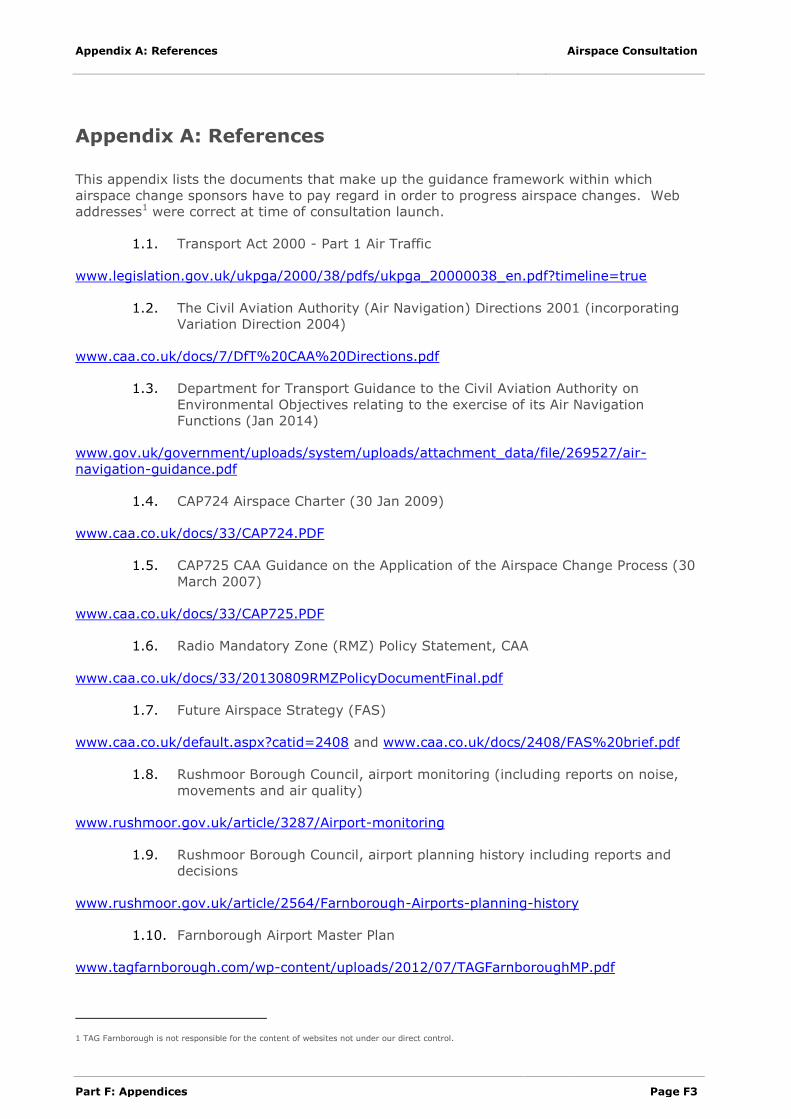
Appendix A: References
This appendix lists the documents that make up the guidance framework within which
airspace change sponsors have to pay regard in order to progress airspace changes. Web
addresses1 were correct at time of consultation launch.
1.1. Transport Act 2000 - Part 1 Air Traffic
www.legislation.gov.uk/ukpga/2000/38/pdfs/ukpga_20000038_en.pdf?timeline=true
1.2. The Civil Aviation Authority (Air Navigation) Directions 2001 (incorporating
Variation Direction 2004)
www.caa.co.uk/docs/7/DfT%20CAA%20Directions.pdf
1.3. Department for Transport Guidance to the Civil Aviation Authority on
Environmental Objectives relating to the exercise of its Air Navigation
Functions (Jan 2014)
www.gov.uk/government/uploads/system/uploads/attachment_data/file/269527/air-
navigation-guidance.pdf
1.4. CAP724 Airspace Charter (30 Jan 2009)
www.caa.co.uk/docs/33/CAP724.PDF
1.5. CAP725 CAA Guidance on the Application of the Airspace Change Process (30
March 2007)
www.caa.co.uk/docs/33/CAP725.PDF
1.6. Radio Mandatory Zone (RMZ) Policy Statement, CAA
www.caa.co.uk/docs/33/20130809RMZPolicyDocumentFinal.pdf
1.7. Future Airspace Strategy (FAS)
www.caa.co.uk/default.aspx?catid=2408 and www.caa.co.uk/docs/2408/FAS%20brief.pdf
1.8. Rushmoor Borough Council, airport monitoring (including reports on noise,
movements and air quality)
www.rushmoor.gov.uk/article/3287/Airport-monitoring
1.9. Rushmoor Borough Council, airport planning history including reports and
decisions
www.rushmoor.gov.uk/article/2564/Farnborough-Airports-planning-history
1.10. Farnborough Airport Master Plan
www.tagfarnborough.com/wp-content/uploads/2012/07/TAGFarnboroughMP.pdf
1 TAG Farnborough is not responsible for the content of websites not under our direct control.
Airspace Consultation Appendix A: References
Page F4 Part F: Appendices
1.11. US Army Public Health Command, Operational Noise for aircraft including
CH-47 Chinook helicopters
www.energy.gov/sites/prod/files/EA-1606-DEA-AppendixC-2011_1.pdf
Appendix B: Glossary Airspace Consultation
Part F: Appendices Page F5
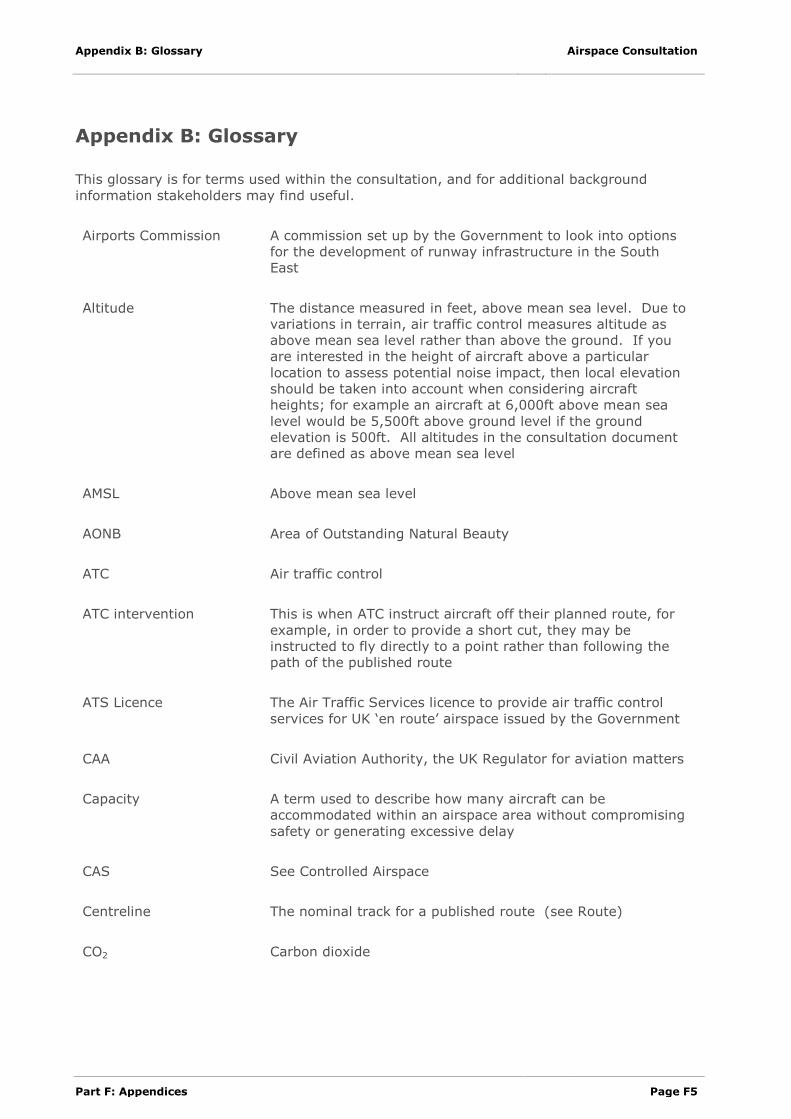
Appendix B: Glossary
This glossary is for terms used within the consultation, and for additional background
information stakeholders may find useful.
Airports Commission A commission set up by the Government to look into options
for the development of runway infrastructure in the South
East
Altitude The distance measured in feet, above mean sea level. Due to
variations in terrain, air traffic control measures altitude as
above mean sea level rather than above the ground. If you
are interested in the height of aircraft above a particular
location to assess potential noise impact, then local elevation
should be taken into account when considering aircraft
heights; for example an aircraft at 6,000ft above mean sea
level would be 5,500ft above ground level if the ground
elevation is 500ft. All altitudes in the consultation document
are defined as above mean sea level
AMSL Above mean sea level
AONB Area of Outstanding Natural Beauty
ATC Air traffic control
ATC intervention This is when ATC instruct aircraft off their planned route, for
example, in order to provide a short cut, they may be
instructed to fly directly to a point rather than following the
path of the published route
ATS Licence The Air Traffic Services licence to provide air traffic control
services for UK ‘en route’ airspace issued by the Government
CAA Civil Aviation Authority, the UK Regulator for aviation matters
Capacity A term used to describe how many aircraft can be
accommodated within an airspace area without compromising
safety or generating excessive delay
CAS See Controlled Airspace
Centreline The nominal track for a published route (see Route)
CO2 Carbon dioxide
Airspace Consultation Appendix B: Glossary
Page F6 Part F: Appendices
Concentration Refers to a density of aircraft flight paths over a given
location; generally refers to high density where tracks are not
spread out; this is the opposite of Dispersal
Consultation swathe This is the broad area within which we will need to position a
route
Continuous climb or
continuous descent
A climb or descent that is constant, without periods of level
flight – the latter is referred to as step climb or step descent
Controlled airspace (CAS) Generic term for the airspace in which an air traffic control
service is provided as standard; note that there are different
sub classifications of airspace that define the particular air
traffic services available in defined classes of controlled
airspace.
Abbreviated to CAS
Conventional navigation The historic navigation standard where aircraft fly with
reference to ground based navigation aids
Conventional routes Routes defined to the conventional navigation standard
Davies Commission See Airports Commission
Dispersal Refers to the density of aircraft flight paths over a given
location; generally refers to low density – tracks that are
spread out; this is the opposite of Concentration
Easterly operation When an runway is operating such that aircraft are taking off
and landing in an easterly direction; see Runway 06 for
Farnborough operations
FAS See Future Airspace Strategy
Final approach path The final part of a flight path that is lined up with the runway;
Farnborough aircraft usually join final approach between 6nm
and 10nm from the runway
Flight plan The flight path that an aircraft has to carry fuel for, which
covers the whole route, not including any changes to the
flight-path made tactically by air traffic control – which may
be either to shorten the flight-path when it is not busy or
lengthen the flight-path when there is a queue to land
Flight-path The track flown by aircraft when following a route, or when
being directed by air traffic control (see also Vector)
Appendix B: Glossary Airspace Consultation
Part F: Appendices Page F7
ft, feet The standard measure for vertical distances used in air traffic
control
Fuel uplift The amount of fuel that aircraft have to carry on a journey,
this includes the fuel for the flight plan, contingency fuel for
airborne delay and contingency for emergencies
Future Airspace Strategy The CAA’s blueprint for modernising the UK’s airspace.
GA See General Aviation
GAL Gatwick Airport Limited
General Aviation (GA) All civil aviation operations other than scheduled air services
and non-scheduled air transport operations for remuneration
or hire. Farnborough airport is predominantly used by
commercial corporate jet flights. These are not considered
general aviation flights in this consultation. The most
common type of GA activity is recreational flying by private
light aircraft and gliders, but it can range from paragliders and
parachutists to microlights and private corporate jet flights.
Holds/Holding Stacks An airspace structure where aircraft circle above one another
at 1,000ft intervals when queuing to land. At Farnborough
these are only used for contingency circumstances
Intermediate airspace Airspace with routes at altitudes between 4,000ft and 7,000ft
Airports and the national ‘en route’ ATC agency both have
requirements to use this airspace.
LAMP London Airspace Management Programme
Low altitude airspace Airspace in the vicinity of the airport containing arrival and
departure routes below 4,000ft. Airports have the primary
accountability for this airspace, as its design and operation is
largely dictated by local noise requirements, airport capacity
and efficiency
MOD Ministry of Defence
NATS The UK’s licenced air traffic service provider for the en route
airspace that connects our airports with each other, and with
the airspace of neighbouring states
Nautical Mile Aviation measures distances in nautical miles. One nautical
mile (nm) is 1,852 metres. One road mile (‘statute mile’) is
1,609 metres, making a nautical mile about 15% longer than
a statute mile.
Airspace Consultation Appendix B: Glossary
Page F8 Part F: Appendices
Network airspace En route airspace above 7,000ft in which NATS has
accountability for safe and efficient air traffic services for
aircraft travelling between the UK airports and the airspace of
neighbouring states
nm See Nautical Mile
OCAS Outside Controlled Airspace (see Uncontrolled Airspace).
p/a Per annum (per year)
PBN See Performance Based Navigation
Performance Based
Navigation (PBN)
Referred to as PBN; a generic term for modern standards for
aircraft navigation capabilities (as opposed to ‘conventional’
navigation standards).
Radar, radar blip, radar
target, radar return
Generic terms covering how ATC ‘sees’ the air traffic in the
vicinity. One type of radar (Primary) sends out radio pulses
that are reflected back to the receiver (the ‘return’), defining
the target’s position accurately and displaying a marker on
the controller’s screen (‘blip’ or ‘target’).
The other type (Secondary, often attached to the Primary and
rotating at the same speed) sends out a request for
information and receives coded numbers by return (see
Transponder). These numbers are decoded and displayed on
top of the Primary return, showing an accurate target with
callsign identity and altitude.
Many airports (such as Farnborough) have their own radars,
and also receive feeds from other local radars in order to
reduce the impact of any one failure.
Radio Mandatory Zone
(RMZ)
A region where all airspace users are required to communicate
with ATC even if outside CAS, maintaining their operational
freedom.
This is an airspace structure that is being considered as one
element of this proposal.
RNAV Short for aRea NAVigation. This is a generic term for a
particular specification of Performance Based Navigation
RNAV1 See RNAV. The suffix ‘1’ denotes a requirement that aircraft
can navigate to with 1nm of the centreline of the route 95%
or more of the time
Appendix B: Glossary Airspace Consultation
Part F: Appendices Page F9
RNAV1 Transition The part of an arrival route, defined to the RNAV1 standard,
between the last part of the hold and the final approach path
to the runway
RNP1 Required Navigation Performance 1. An advanced navigation
specification under the PBN umbrella. The suffix ‘1’ denotes a
requirement that aircraft can navigate to with 1nm of the
centreline 95% or more of the time, with additional self-
monitoring criteria
Route Published routes that aircraft plan to follow. These have a
nominal centreline that give an indication of where aircraft on
the route would be expected to fly; however, aircraft will fly
routes and route segments with varying degrees of accuracy
based on a range of operational factors such as the weather,
ATC intervention, and technical factors such as the PBN
specification
Route system or
route structure
The network of routes linking airports to one another and to
the airspace of neighbouring states.
Runway 06
(Farnborough)
The name given to the runway at Farnborough when
operating in an ‘easterly’ direction (i.e. taking off and landing
on the easterly heading of 060º)
Runway 24
(Farnborough)
The name given to the runway at Farnborough when
operating in a ‘westerly‘ direction (i.e. taking off and landing
on the westerly heading of 240º)
Separation Aircraft under Air Traffic Control are kept apart by standard
separation distances, as agreed by international safety
standards. Participating aircraft are kept apart by at least
3nm lateral separation or 1,000ft vertical separation. These
distances are different in certain airspace environments,
however the ones stated here are used at Farnborough.
Sequence The order of arrivals in a queue of airborne aircraft waiting to
land
SID See Standard Instrument Departure
Simulation modelling Computer based analysis where the air traffic is ‘flown’
through a virtual airspace system; used to assess the effects
of changing airspace and routes on the efficiency of air traffic
flows
Airspace Consultation Appendix B: Glossary
Page F10 Part F: Appendices
Standard Arrival Route The published routes for arriving traffic. In today’s system
these bring aircraft from the route network to the holds (some
distance from the airport), from where they follow ATC
instructions (see Vector) rather than a published route. Under
PBN the published arrival route would go most of the way to
the runway, reducing controller workload.
Standard Instrument
Departure
Usually abbreviated to SID; this is a route for departures to
follow straight after take-off
STAR See Standard Arrival Route
Statute mile A standard mile as used in normal day to day situations (e.g.
road signs) but not for air traffic where nautical miles are
used
Stepped climb A climb that is interrupted by periods of level flight required to
keep the aircraft separated from another route in the airspace
above
Stepped descent A descent that is interrupted by periods of level flight required
to keep the aircraft separated from another route in the
airspace below
Systemisation The process of reducing the need for human intervention in
the air traffic control system, primarily by utilising improved
navigation capabilities to develop a network of routes that are
safely separated from one another so that aircraft are
guaranteed to be kept apart without the need for air traffic
control to intervene so often
Tactical methods Air traffic control methods that involve controllers directing
aircraft for specific reasons at that particular moment (see
Vector)
Terminal airspace An aviation term to describe a designated area of controlled
airspace surrounding a major airport or cluster of airports
where there is a high volume of traffic; a large part of the
airspace above London and the South East is defined as
terminal airspace (or Terminal Manoeuvring Area – TMA).
This is the airspace that contains all the arrival and departure
routes for Heathrow, Gatwick, Stansted, Luton and London
City from around 2,000ft-3,000ft up to approximately
20,000ft. Farnborough is below the London TMA.
Tonne, t Metric Tonne (1,000kg)
Appendix B: Glossary Airspace Consultation
Part F: Appendices Page F11
Transponder An electronic device on board aircraft which sends out coded
information which is picked up by radar and other systems.
Most importantly the aircraft altitude, and identity code, by
which the aircraft can be identified on the radar screen.
Transponder Mandatory
Zone (TMZ)
A region where all airspace users are required to use a
functioning transponder even if outside CAS, maintaining their
operational freedom.
This is an airspace structure that has currently been
discounted from this proposal.
Uncontrolled Airspace Generic term for the airspace in which no air traffic control
service is provided as standard. The airspace surrounding
Farnborough airport is currently uncontrolled airspace. Any
aircraft can fly in this airspace without having to contact
Farnborough ATC. This means that Farnborough ATC do not
have control over all aircraft in the airspace, and do not have
information on many of the aircraft that may be present in the
airspace. Aircraft that are not participating in ATC services
are referred to as ‘unknown traffic’.
Unknown traffic Aircraft not participating in ATC services. They may show on
radar with altitude information (if they are operating with a
Transponder) or in the worst case they will only show as a blip
on the radar screen (a radar primary return) with no other
information. If ATC sees a primary return on radar, they have
to assume that it could be at the same altitude as any flight
they are controlling, and hence the flight has to be tactically
vectored to safely avoid it.
Vector, Vectoring,
Vectored
An air traffic control method that involves directing aircraft off
the established route structure or off their own navigation –
ATC instruct the pilot to fly on a compass heading and at a
specific altitude. In a busy tactical environment, these can
change quickly.
This is done for safety and for efficiency.
Westerly operation When a runway is operating such that aircraft are taking off
and landing in a westerly direction; e.g. when Runway 24 is in
use at Farnborough, the airport is said to be on westerly
operations.
Airspace Consultation Appendix C: Stakeholder List
Page F12 Part F: Appendices
Appendix C: Stakeholder List
This appendix lists the stakeholders who have been identified for inclusion in the initial
distribution of consultation material.
Whilst we have tried to predict all relevant stakeholders, it is impossible to identify everyone
who may have an interest.
Anyone who considers themselves a stakeholder may respond to this consultation.
Appendix C: Stakeholder List Airspace Consultation
Part F: Appendices Page F13
Parliamentary Constituencies
Aldershot
Arundel and South Downs
Basingstoke
Bognor Regis and Littlehampton
Bournemouth East
Bournemouth West
Bracknell
Brighton, Kemptown
Brighton, Pavilion
Chichester
Christchurch
Dorset County
East Hampshire
East Worthing and Shoreham
Eastleigh
Esher and Walton
Fareham
Gosport
Guildford
Hampshire County
Havant
Horsham
Hove
Isle of Wight
Meon Valley
Mid Dorset and North Poole
Mole Valley
New Forest East
Parliamentary Constituencies
(continued)
New Forest West
Newbury
North Dorset
North East Hampshire
North West Hampshire
Poole
Portsmouth North
Portsmouth South
Reading West
Romsey and Southampton North
Runnymede and Weybridge
South Dorset
South West Surrey
Southampton, Itchen
Southampton, Test
Surrey County
Surrey Heath
West Sussex County
Winchester
Windsor
Woking
Wokingham
Worthing West
County Councils
Dorset
Hampshire

Airspace Consultation Appendix C: Stakeholder List
Page F14 Part F: Appendices
County Councils (continued)
Surrey
West Sussex
Borough Councils & Unitary
Authorities
Adur
Arun
Basingstoke and Deane
Bournemouth
Bracknell Forest
Chichester
City of Brighton and Hove
City of Portsmouth
City of Southampton
East Dorset
East Hampshire
Eastleigh
Elmbridge
Fareham
Gosport
Guildford
Hart
Havant
Horsham
Isle of Wight
Mid Sussex
Mole Valley
New Forest
Borough Councils & Unitary
Authorities (continued)
Poole
Reading
Runnymede
Rushmoor
Surrey Heath
Test Valley
Waverley
West Berkshire
Winchester
Windsor and Maidenhead
Woking
Wokingham
Worthing
National Air Traffic Management
Advisory Committee (NATMAC)
Aircraft Owners and Pilots Association
(AOPA)
Aviation Environment Federation
BAE Systems
British Air Transport Association (BATA)
British Airline Pilots’ Association (BALPA)
British Airways
British Balloon & Airship Club (BBAC)
British Business & General Aviation
Association (BBGA)
British Gliding Association (BGA)
British Hang Gliding & Paragliding
Association (BHPA)
Appendix C: Stakeholder List Airspace Consultation
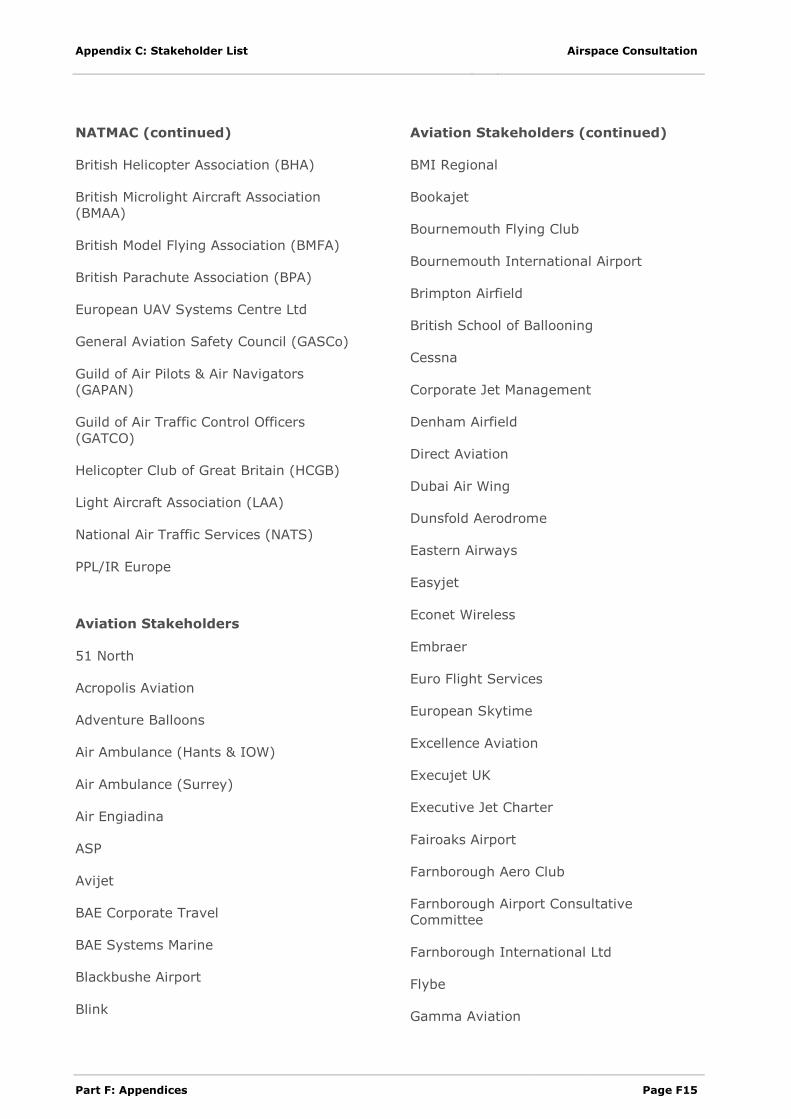
Part F: Appendices Page F15
NATMAC (continued)
British Helicopter Association (BHA)
British Microlight Aircraft Association
(BMAA)
British Model Flying Association (BMFA)
British Parachute Association (BPA)
European UAV Systems Centre Ltd
General Aviation Safety Council (GASCo)
Guild of Air Pilots & Air Navigators
(GAPAN)
Guild of Air Traffic Control Officers
(GATCO)
Helicopter Club of Great Britain (HCGB)
Light Aircraft Association (LAA)
National Air Traffic Services (NATS)
PPL/IR Europe
Aviation Stakeholders
51 North
Acropolis Aviation
Adventure Balloons
Air Ambulance (Hants & IOW)
Air Ambulance (Surrey)
Air Engiadina
ASP
Avijet
BAE Corporate Travel
BAE Systems Marine
Blackbushe Airport
Blink
Aviation Stakeholders (continued)
BMI Regional
Bookajet
Bournemouth Flying Club
Bournemouth International Airport
Brimpton Airfield
British School of Ballooning
Cessna
Corporate Jet Management
Denham Airfield
Direct Aviation
Dubai Air Wing
Dunsfold Aerodrome
Eastern Airways
Easyjet
Econet Wireless
Embraer
Euro Flight Services
European Skytime
Excellence Aviation
Execujet UK
Executive Jet Charter
Fairoaks Airport
Farnborough Aero Club
Farnborough Airport Consultative
Committee
Farnborough International Ltd
Flybe
Gamma Aviation
Airspace Consultation Appendix C: Stakeholder List
Page F16 Part F: Appendices
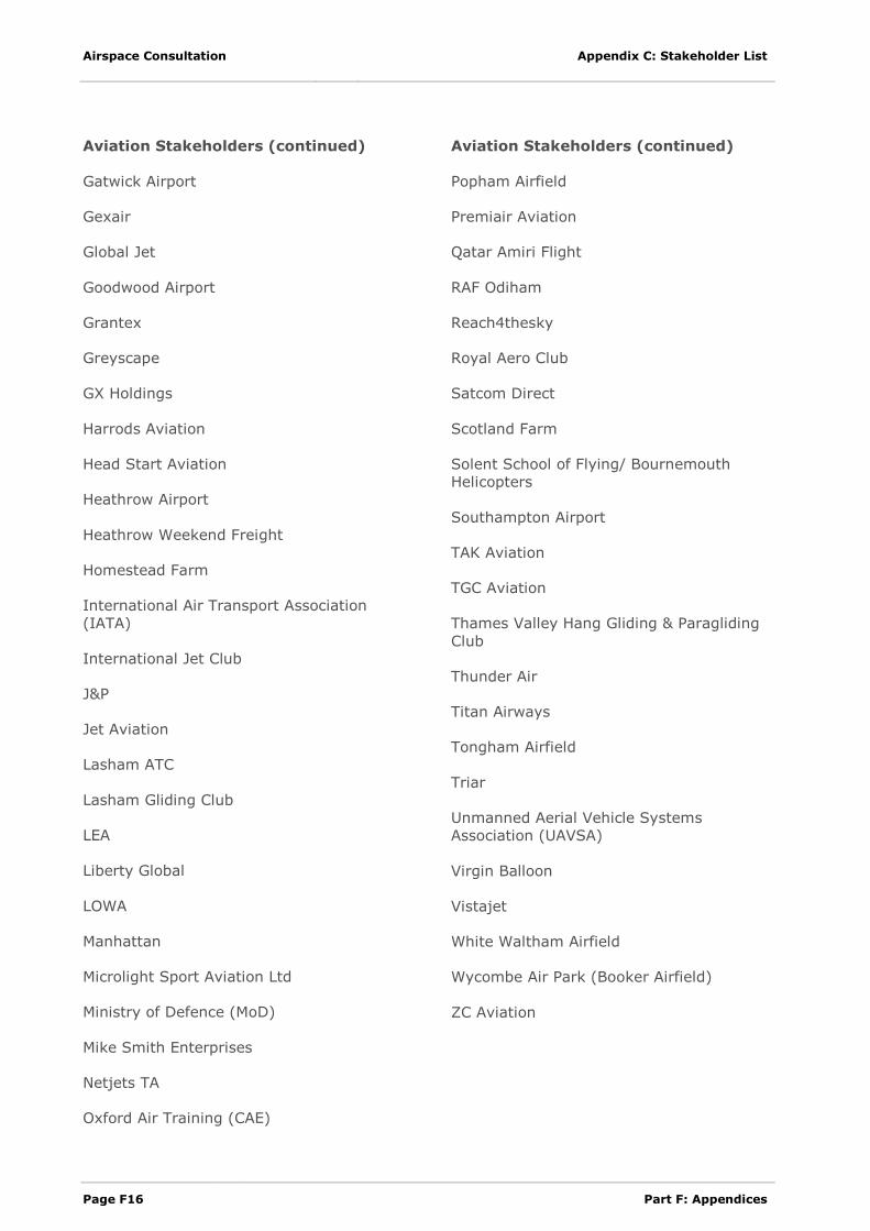
Aviation Stakeholders (continued)
Gatwick Airport
Gexair
Global Jet
Goodwood Airport
Grantex
Greyscape
GX Holdings
Harrods Aviation
Head Start Aviation
Heathrow Airport
Heathrow Weekend Freight
Homestead Farm
International Air Transport Association
(IATA)
International Jet Club
J&P
Jet Aviation
Lasham ATC
Lasham Gliding Club
LEA
Liberty Global
LOWA
Manhattan
Microlight Sport Aviation Ltd
Ministry of Defence (MoD)
Mike Smith Enterprises
Netjets TA
Oxford Air Training (CAE)
Aviation Stakeholders (continued)
Popham Airfield
Premiair Aviation
Qatar Amiri Flight
RAF Odiham
Reach4thesky
Royal Aero Club
Satcom Direct
Scotland Farm
Solent School of Flying/ Bournemouth
Helicopters
Southampton Airport
TAK Aviation
TGC Aviation
Thames Valley Hang Gliding & Paragliding
Club
Thunder Air
Titan Airways
Tongham Airfield
Triar
Unmanned Aerial Vehicle Systems
Association (UAVSA)
Virgin Balloon
Vistajet
White Waltham Airfield
Wycombe Air Park (Booker Airfield)
ZC Aviation
Appendix C: Stakeholder List Airspace Consultation
Part F: Appendices Page F17
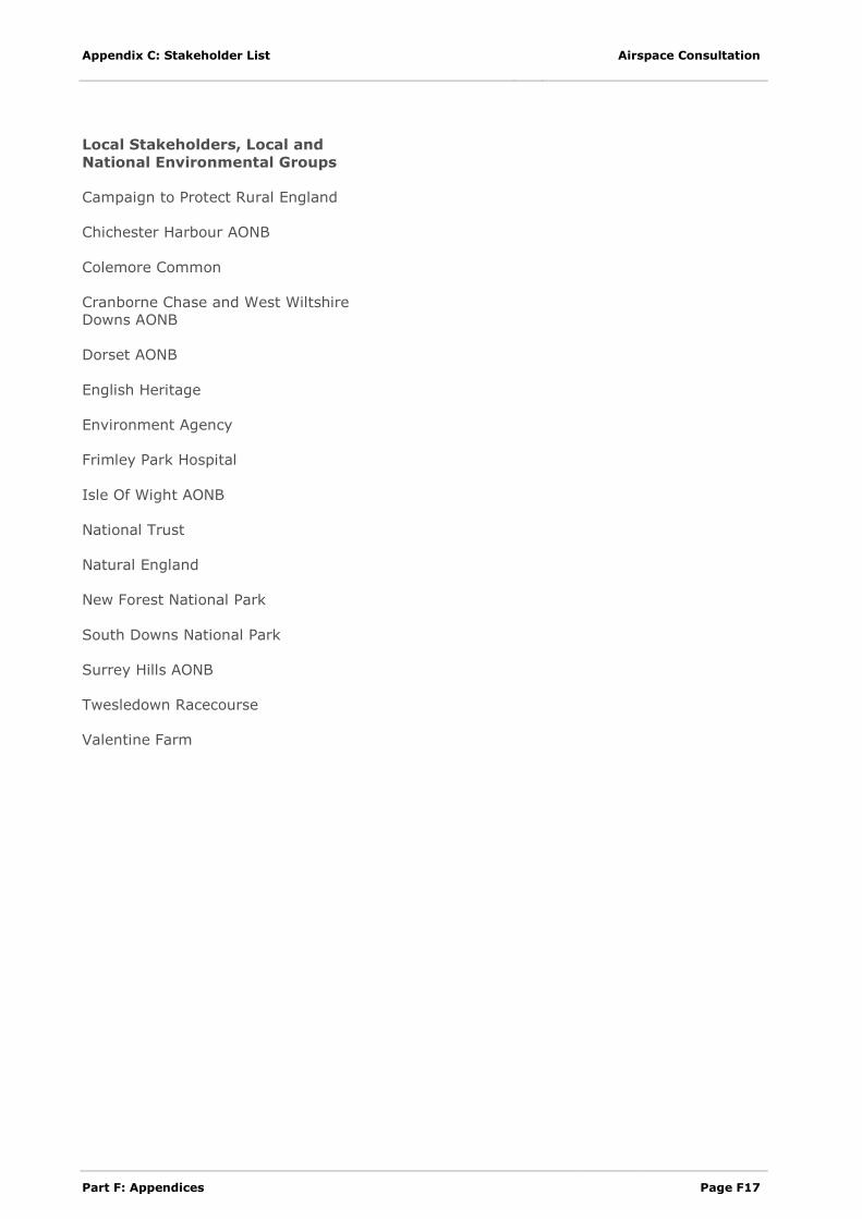
Local Stakeholders, Local and
National Environmental Groups
Campaign to Protect Rural England
Chichester Harbour AONB
Colemore Common
Cranborne Chase and West Wiltshire
Downs AONB
Dorset AONB
English Heritage
Environment Agency
Frimley Park Hospital
Isle Of Wight AONB
National Trust
Natural England
New Forest National Park
South Downs National Park
Surrey Hills AONB
Twesledown Racecourse
Valentine Farm
Airspace Consultation Appendix C: Stakeholder List
Page F18 Part F: Appendices
This page is intentionally blank