Air and Space Museum Features WAAS Experts - FAA: Home
6
VOLUME 49 Fall 2013 On September 25, 2013, the Time and Navigation exhibit at the National Air and Space Museum on the National Mall in Washington, DC featured experts on the Wide Area Augmentation System (WAAS) to answer questions about the benefits of WAAS and explain the workings of satellite navigation. WAAS, which increases the accuracy and Inside ... http://gps.faa.gov Federal Aviation Administration 800 Independence Avenue, SW Washington, DC 20591 The SatNav News is produced by the Navigation Programs AJM-32 branch of the Federal Aviation Administration (FAA). This newsletter provides informa- tion on the Global Positioning System (GPS), the Wide Area Augmentation System (WAAS) and the Ground Based Augmentation System (GBAS). 1 Air and Space Museum Features WAAS Experts 3 FAA Gathering Celebrates WAAS Tenth Anniversary 3 WAAS Finds Old Fishing Gear in Puget Sound in Washington State 4 GEO 5 Lease in Place 5 WAAS Has Potential to Aid Unmanned Aircraft Systems (UAS) in Arctic 5 Less Noise for Long Island Endangered Birds 6 What’s New on the Web 6 Satellite Navigation Approach Procedures Update We’re collecting testimonials about the benefits of Wide Area Augmentation System (WAAS) navigation from users. If you are a pilot, passenger, airport manager, airline employee, or are involved in aviation in any capacity - whether you fly fixed-wing or vertical flight aircraft - we want to hear from you! Please send your stories and contact information to Mary Ann Davis at [email protected] Tell Us Your WAAS Story The entrance to the Time and Navigation exhibit at the National Air and Space Museum Air and Space Museum Features WAAS Experts
Transcript of Air and Space Museum Features WAAS Experts - FAA: Home

VOLUME 49Fall 2013
On September 25 2013 the Time and Navigation exhibit at the National Air and Space Museum on the National Mall in Washington DC featured experts on the Wide Area
Augmentation System (WAAS) to answer questions about the benefits of WAAS and explain the workings of satel l ite nav igation WA AS which increases the accuracy and
Inside
httpgpsfaagov
Federal Aviation Administration 800 Independence Avenue SW Washington DC 20591
The SatNav News is produced by the Navigation Programs AJM-32 branch of the Federal Aviation Administration (FAA) This newsletter provides informa-tion on the Global Positioning System (GPS) the Wide Area Augmentation System (WAAS) and the Ground Based Augmentation System (GBAS)
1 Air and Space Museum Features WAAS Experts
3 FAA Gathering Celebrates WAAS Tenth Anniversary
3 WAAS Finds Old Fishing Gear in Puget Sound in Washington State
4 GEO 5 Lease in Place
5 WAAS Has Potential to Aid Unmanned Aircraft Systems (UAS) in Arctic
5 Less Noise for Long Island Endangered Birds
6 Whatrsquos New on the Web
6 Satellite Navigation Approach Procedures Update
Wersquore collecting testimonials about the benefits of Wide Area Augmentation System (WAAS) navigation from users If you are a pilot passenger airport manager airline employee or are involved in aviation in any capacity - whether you fly fixed-wing or vertical flight aircraft - we want to hear from you Please send your stories and contact information to Mary Ann Davis atmaryannctrdavisfaagov
Tell Us Your WAAS Story
The entrance to the Time and Navigation exhibit at the National Air and Space Museum
Air and Space Museum Features WAAS Experts
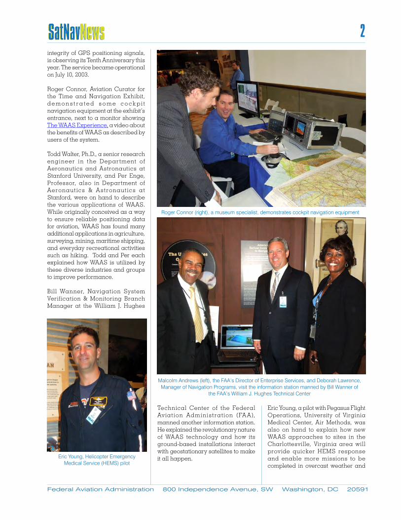
integrity of GPS positioning signals is observing its Tenth Anniversary this year The service became operational on July 10 2003
Roger Connor Aviation Curator for the Time and Navigation Exhibit d e m o n s t r a te d s o m e c o c k p i t navigation equipment at the exhibitrsquos entrance next to a monitor showing The WAAS Experience a video about the benefits of WAAS as described by users of the system
Todd Walter PhD a senior research engineer in the Department of Aeronautics and Astronautics at Stanford University and Per Enge Professor also in Department of Aeronaut ics amp Astronaut ics a t Stanford were on hand to describe the various applications of WAAS While originally conceived as a way to ensure reliable positioning data for aviation WAAS has found many additional applications in agriculture surveying mining maritime shipping and everyday recreational activities such as hiking Todd and Per each explained how WAAS is utilized by these diverse industries and groups to improve performance
Bil l Wanner Navigation System Verification amp Monitoring Branch Manager at the William J Hughes
Technical Center of the Federal Av iat ion Administrat ion (FA A) manned another information station He explained the revolutionary nature of WAAS technology and how its ground-based installations interact with geostationary satellites to make it all happen
Eric Young a pilot with Pegasus Flight Operations University of Virginia Medical Center Air Methods was also on hand to explain how new WAAS approaches to sites in the Charlottesville Virginia area will provide quicker HEMS response and enable more missions to be completed in overcast weather and
Federal Aviation Administration 800 Independence Avenue SW Washington DC 20591
2
Roger Connor (right) a museum specialist demonstrates cockpit navigation equipment
Malcolm Andrews (left) the FAArsquos Director of Enterprise Services and Deborah Lawrence Manager of Navigation Programs visit the information station manned by Bill Wanner of
the FAArsquos William J Hughes Technical Center
Eric Young Helicopter Emergency Medical Service (HEMS) pilot
mountainous terrain Pegasus is a hospital-based air and ground transport service providing care to critically ill or injured patients Mike Webb of the FAArsquos Flight Standards group working with Hel icopter Instrument Criteria was with Eric to talk about the nature of helicopter approaches and the FAArsquos plans to increase their number
Tom Kramer Manager of Airspace and Modernization for the Aircraft Owners and Pi lots Associat ion (AOPA) and Luz Beattie one of AOPArsquos corporate pilots talked about how WAAS has been enthusiastically embraced by General Aviation (GA) pilots who often utilize small airfields that do not have expensive Instrument Landing System (ILS) installations to guide approaching planes
Visitors included many FAA personnel who walked over to the museum during their lunch break to find out more about this highly beneficial and cost-effective service provided by their agency Further information about the Time and Space Exhibit can be found at the following web address httpstimeandnavigationsieduresearchwaas-meet-the-expert-educational-event
FAA Gathering Celebrates WAAS Tenth AnniversaryA gathering at the Washington DC headquarters of the Federal Aviation Administration (FAA) at 800 Independence Avenue was held Wednesday September 25 2013 to celebrate the tenth anniversary of the Wide Area Augmentation System (WAAS) which was commissioned into service on July 10 2003
FAA employees and contractors along with other key stakeholders and users of the WAAS service heard a rousing keynote address by FAA Navigation Programs Manager Deborah Lawrence Ms Lawrence talked about the development of WAAS the growth in the number of aircraft equipped with WAAS avionics the application of WAAS
service outside of aviation by those in agriculture mining and maritime occupations and the future plans for the system Ms Lawrence thanked all present for continuing to maintain and improve the WAAS program ldquofor the good of the countryrdquo
Other speakers included Malcolm A ndrews the FA A Director of Enterprise Services which oversees the WAAS program Jeff Christoffers a Program Manager for the Raytheon Company the primary contractor for WAAS Dan Hanlon the FAArsquos WA AS Program Manager when the system was commissioned in
2003 and Tom Kramer Manager of A irspace and Modernization for the Aircraft Owners and Pilots Association (AOPA)who emphasized his organizationrsquos long standing support for the WAAS program and how WAAS has benefited General Aviation pilots
WAAS Finds Old Fishing Gear in Puget Sound in Washington StateIn Washington State the Puget Sound Derel ict Fishing Gear Removal Project managed by the Northwest Straits Marine Conservation Initiative (NWSI) has been locating and
Federal Aviation Administration 800 Independence Avenue SW Washington DC 20591
3
Tom Kramer of the Aircraft Owners and Pilots Association (AOPA)
removing derelict fishing gear since 2002 Nets (gillnets and purse seines) mostly from previous decades of heavy salmon fishing and crab pots from both commercial and recreational Dungeness crab fisheries are what constitute the majority of gear types found to be derelict in the Puget Sound Derelict gear targets are identif ied through sidescan sonar surveys and dive surveys then are entered into the statewide derel ict f ishing gear database Using GPS receivers equipped with Wide Area Augmentation System
(WAAS) circuitry the dive team and biologist identify targets and load them into navigation software which is later used when returning to target locations Highly trained divers using surface supplied air descend to the seafloor and manually remove the derelict gear The gear is attached to a recovery line and retrieved by the dive removal vessel An onboard biologist records the characteristics of the removed derelict gear item as well as all live and dead organisms found entangled
As of August 31 2013 the NWSI with Natural Resources Consultants Inc (NRC) have removed 4500 derelict fishing nets and over 3000 crab pots restoring more than 640 acres of critical marine habitat Over 316000 animals representing more than 240 unique species were found entangled in this gear Species found include porpoise sea lions scoters grebes cormorants rockfish salmon and Dungeness crab
Precision is important in ensuring safe and effective dive operations for derelict fishing gear removals in the Puget Sound Several steps are included in the process from target identif ication to target removal Initial recording of accurate target coordinates by the survey team is essential in ensuring that the dive removal team will be able to locate the target in the future Equally as important is the ability of the dive team to navigate the vessel and eventually the diver to the derelict gear target for removal Variables in sea conditions underwater visibility tidal currents water depth and weather all play a factor in these operations and can affect the ease in which a target is found Using GPS augmented by WAAS provides a high level of precision in both target identification and retrieval at a low cost helping minimize the challenges posed by the variables encountered in the marine environment - Kyle Antonelis Project ManagerFishery Analyst Natural Resources Consultants Inc
GEO 5 Lease in PlaceBased on a proposal from the Raytheon Company of Fullerton California offering the SatMex 9 satellite as the Wide Area Augmentation System (WAAS) Geostationary Earth Orbit 5 (GEO 5) the WAAS Program Office has issued Raytheon the Authorization to Proceed with Phase 1 of the contract on July 11 2013 SatMex 9 has an anticipated in-orbit date of August 2016 with operational integration into WAAS to be completed in September 2017 The 10-year lease will begin once the satellite is integrated into WAAS
Federal Aviation Administration 800 Independence Avenue SW Washington DC 20591
4
5
Federal Aviation Administration 800 Independence Avenue SW Washington DC 20591
The Post Contract Award Meeting with Raytheon was conducted on August 6th and 7th of 2013 The first Technical Exchange Meeting and the Integrated Baseline Review will be conducted during the week of October 14 2013
The WAAS Program uses a hosted payload on a commercial satellite The FAA has conducted a study to compare the costs for leasing a hosted payload versus buying and operating an entire satellite and determined the use of a leased service was more cost-effective - Scott Speed FAA AJM-321NAVTAC
WAAS Has Potential to Aid Unmanned Aircraft Systems (UAS) in ArcticWhen Congress passed the FAA Modernization and Reform Act of 2012 it directed the FAA to ldquodevelop a plan and initiate a processrdquo to designate permanent areas in the Arctic where small unmanned aircraft systems (sUAS) may operate 24 hours per day for research and commercial purposes In August 2013 the FAA issued ldquorestricted category type certificatesrdquo to a pair of sUAS devices The action ldquowill lead to the first approved commercial UAS operationsrdquo the FAA said
The newly certified UAS include the ScanEagle X200 from Insitu Inc a Bingen Washington subsidiary of The Boeing Co and the Puma AE from AeroVironment Inc headquartered in Monrovia California
ldquoA major energy company plans to fly the ScanEagle off the Alaska coast in international waters starting in Augustrdquo the FAA said ldquoPlans for the initial ship-launched flights include surveys of ocean ice floes and migrating whales in Arctic oil exploration areas The Puma is expected to support emergency response crews for oil spill monitoring and wildlife surveillance over the Beaufort Seardquo
Issu ing the cer t i f ica tes is an important step toward the FAArsquos goal of integrating UAS into the nationrsquos airspace These flights will also meet requirements in the FAA Modernization and Reform Act of 2012 that define Arctic operational areas and include a mandate to increase Arctic UAS commercial operations
The FAA announcement takes the first steps in what is expected to be high utilization of UAS in the Arctic with benefits for bull Scientific researchbull Search and Rescue (SAR)bull Environmental analysisbull Fisheriesbull Marine mammal observersbull Oil and gas leaseholdersbull Maritime route plannersbull Other uses as technologies and
performance characteristics become better understood and integrated into UAS operations
The expansion in the use of unmanned aircraft is also expected to involve the utilization of a Space Based
Augmentation System (SBAS) The American SBAS is called the Wide Area Augmentation System (WAAS) In Alaska using WAAS for UAS has many performance enhancing benefits over GPS These benefits includebull Better accuracy and performance
which will greatly improve future Sense and Avoid applications for UAS
bull Provides greater service volume coverage over the Northern Hemisphere with WAAS and other SBAS such as EGNOS SDCM MSAS and GAGAN International cooperation will work out any interoperability issues
bull WAAS is required to fly all T routes whether inside or outside of surveillance radar coverage (May only operate on GNSS (GPS) Q routes with GPS TSO-C129 (as revised) or TSO C196 (as revised) equipment while the aircraft remains in Air Traffic Control (ATC) radar surveillance or w i th GPS WA AS wh ich does not require ATC radar surveillance)
- Scott Speed FAA AJM-321NAVTAC
Less Noise for Long Island Endangered Birds The Piping Plover (Charadrius melodus) is a small sand-colored sparrow -s ized shorebird that nests and feeds along coastal sand and gravel beaches in North America With a population that has dwindled to around 6000 the bird is an endangered species and the protection of its habitat is a top priority for federal state and local environmental agencies
A Localizer Performance with Vertical guidance (LPV) depiction voluntarily flown using Visual Flight Rules (VFR) only into the Southampton Heliport in Southampton New York enables pilots to avoid disturbing the Piping Plover nesting grounds off Shinnecock Bay along the south shore of Long Island The VFR LPV depiction curves over
The Puma AE small Unmanned Aircraft System (sUAS)
Federal Aviation Administration 800 Independence Avenue SW Washington DC 20591
6
the Bay rather than flying overland thus minimizing noise and turbulence The depiction also minimizes noise for local residents
The Eastern Region Helicopter Council an organization of helicopter operators in the area has advised its membership of the new depiction and many have voluntarily adopted it causing a much quieter summer for residents of the Hamptons whether human or avian - Scott Speed FAA AJM-321NAVTAC
Whatrsquos New on the WebWhere can you find FAA Satellite Navigation Program information in between editions of the SATNAV News Please visit our website - httpgpsfaagov Recently we have added a new WAAS status briefing under the Satellite Navigation Library section added the latest WAAS Quarterly Status Report and posted
updated numbers on WAAS approach procedure development Also on our website you can find information about how GPS WAAS and Ground Based Augmentation System (GBAS) work an archive of past SATNAV News editions and fact sheets We are always looking for ways to improve the website and love your suggestions so please feel free to send them to MaryAnnCTRDavisfaagov In the meantime we are working on major updates to many of the existing pages More on that in the next SATNAV News
More information is available at httpswwwfaagovair_trafficflight_infoaeronavproceduresifp_inven-tory_summary
Satellite Navigation Approach Procedures Update The Satel l i te-based Approach Procedures table ref lects the continuing growth of all types of satellite navigation approach procedures For comparison purposes we also include a table noting the recent inventory of Instrument Approach Procedures Based on Conventional NAVAIDs
More detailed information about satellite based instrument approach procedures p lease v i s i t our GPSWAAS Approach Procedures page at http wwwfaagovaboutoffice_org headquarters_officesatoservice_unitstechopsnavservicesgnss approachesindexcfm) - Mary Ann Davis FAA AJM-321NAVTAC