Air Accident Investigation Unit Ireland - static.rasset.ie · Air Accident Investigation Unit...
39
Air Accident Investigation Unit Ireland PRELIMINARY REPORT ACCIDENT Sikorsky S-92A, EI-ICR Black Rock, Co. Mayo, Ireland 14 March 2017
Transcript of Air Accident Investigation Unit Ireland - static.rasset.ie · Air Accident Investigation Unit...

Air Accident Investigation Unit
Ireland
PRELIMINARY REPORT
ACCIDENT Sikorsky S-92A, EI-ICR
Black Rock, Co. Mayo, Ireland
14 March 2017

Sikorsky S-92A, EI-ICR Black Rock, Co. Mayo, Ireland 14 March 2017
PRELIMINARY REPORT
Air Accident Investigation Unit Report 2017-006
1
1 Annex 13: International Civil Aviation Organization (ICAO), Annex 13, Aircraft Accident and Incident
Investigation. 2 Regulation (EU) No 996/2010 of the European Parliament and of the Council of 20 October 2010 on the
investigation and prevention of accidents and incidents in civil aviation. 3 Statutory Instrument (SI) No. 460 of 2009: Air Navigation (Notification and Investigation of Accidents,
Serious Incidents and Incidents) Regulations 2009.
Foreword
This safety investigation is exclusively of a technical nature and the Final Report reflects the determination of the AAIU regarding the circumstances of this occurrence and its probable causes. In accordance with the provisions of Annex 131 to the Convention on International Civil Aviation, Regulation (EU) No 996/20102 and Statutory Instrument No. 460 of 20093, safety investigations are in no case concerned with apportioning blame or liability. They are independent of, separate from and without prejudice to any judicial or administrative proceedings to apportion blame or liability. The sole objective of this safety investigation and Final Report is the prevention of accidents and incidents. Accordingly, it is inappropriate that AAIU Reports should be used to assign fault or blame or determine liability, since neither the safety investigation nor the reporting process has been undertaken for that purpose. Extracts from this Report may be published providing that the source is acknowledged, the material is accurately reproduced and that it is not used in a derogatory or misleading context.

2
1
2
AAIU Report No: 2017-006 State File No: IRL00917016
Report Format: Preliminary Report
Published: 13 April 2017
This Investigation is conducted in accordance with Annex 13 to the Convention on International Civil Aviation, Regulation (EU) No 996/2010 and the provisions of SI 460 of 2009. This Preliminary Report contains information, as known at this time, and does not contain analysis or conclusions. This information is therefore subject to change, and may contain errors; any errors in this Report will be corrected in the Final Report. The sole purpose of this Investigation is the prevention of aviation accidents and incidents. It is not the purpose of this Investigation to apportion blame or liability.
Aircraft Manufacturer: Sikorsky
Model: S-92A
Nationality:
United States of America (USA)
Registration: EI-ICR
State of Registry:
Ireland
Serial Number: 920051
Year of Manufacture:
2007
Type of Operation:
Top Cover for Search and Rescue (SAR)
Date / Time (UTC)4: 14 March 2017 @ 00.46 hrs approximately
Position: Black Rock , Co. Mayo
Persons on Board: Crew - 4
Injuries: Crew - 2 (Fatal) 2 (Missing)
Damage:
Helicopter destroyed
Investigator-In-Charge: Paul Farrell
4 UTC: Co-ordinated Universal Time. All timings in this report are quoted in UTC, which was the same as local time
on the date of the accident.

Sikorsky S-92A, EI-ICR Black Rock, Co. Mayo, Ireland 14 March 2017
PRELIMINARY REPORT
Air Accident Investigation Unit Report 2017-006
3
1 PREAMBLE
1.1 Operation
The Irish Coast Guard (IRCG) is a division of the Department of Transport, Tourism and Sport (DTTAS) and is responsible for Ireland’s national system of marine emergency management within Ireland’s EEZ5 and inland waterways and is designated as the SAR Authority6 in accordance with the provisions of the Irish National Maritime Search and Rescue (SAR) Framework published by the DTTAS. This authority is exercised through a number of regional centres. The helicopter service was provided to the IRCG by a private company7 operating helicopter bases at Dublin, Shannon, Waterford and Sligo. The agreed performance criteria were for the helicopter to achieve a launch time within 15 minutes of urgent calls between the hours of 07.30 hrs and 21.00 hrs and within 45 minutes outside of these times8
1.2 Black Rock
Black Rock is located in the North Atlantic Ocean, to the northwest of Achill Island, Co. Mayo, on the west coast of Ireland. It is the largest of a group of rocks lying approximately nine nm west of Blacksod Bay, Co. Mayo. A lighthouse painted white, 50 ft in height stands on Black Rock. The Irish Aviation Authority (IAA) Aeronautical Chart West shows an elevation of 282 ft for the lighthouse.
2 HISTORY OF THE MISSION At approximately 21.399 hrs on 13 March 2017, the captain of a fishing vessel (FV) contacted Malin Head Marine Rescue Sub Centre (MRSC) to notify them of a medical emergency on board due to an injury to a crewman. The position of the FV at the time of the call was N 54o 17.450’, W 014o 06.944’, which was 141 nm and bearing 270 degrees from Eagle Island, Co. Mayo. The nearest Irish Coast Guard SAR helicopter to the FV was located at Sligo Airport; its crew were on a 45-minute response time to launch. At approximately 21.42 hrs the MRSC Malin contacted the Sligo SAR Crew Duty Pilot. MRSC Malin provided the Duty Pilot with the details of the mission tasking, including the weather conditions and the nature of the medical emergency. The Sligo Duty Pilot accepted the tasking.
5 EEZ: Exclusive Economic Zone.
6 SAR Authority: The authority within a National Administration with overall responsibility for establishing
and providing SAR services and ensuring that planning for those services is properly coordinated. 7 Referred to in this report as ‘the Operator’.
8 As defined in the Operations Manual Part F; Search and Rescue, Section 2 SAR Readiness.
9 Timings used in this mission history are taken from MRSC/MRCC logs. These logs are contemporaneously
maintained but allowance must be made for the fact that timings are manually entered post-fact.

4
1
4
At 21.54 hrs, MRSC Malin contacted the Marine Rescue Coordination Centre (MRCC) Dublin with a request “Dublin helo for top cover”10. MRCC responded that they would advise if an Air Corps CASA was available. At 21.55 hrs, MRSC Malin established a 3-way call/phone-patch with the captain of the FV and a Doctor from the contracted medical service at Cork. After discussing the extent of the injuries, the Doctor asked MRSC Malin “is he [the injured seaman] going to be medevaced11?” MRSC Malin advised that he was. At 22.03 hrs MRSC Malin contacted the Air Corps to pass details of the mission request and the Air Corps undertook to review it and respond. At 22.06 hrs the Air Corps Duty Officer telephoned MRSC Malin to advise that they had no availability until 08.00 hrs. At approximately 22.10 hrs, MRCC called the Duty Pilot of R116 at Dublin for Top Cover for R118’s medevac tasking, and R116 accepted the mission. At approximately 22.20 hrs, a R118 crew member contacted MRSC Malin and received a detailed briefing on the location of the FV and the weather as reported by the captain of the FV. The crew member was informed that Top Cover had been requested. MRCC proceeded to task R116, the Dublin-based Coast Guard SAR Helicopter, to provide Top Cover. At approximately 22.28 hrs, R118 departed Sligo for Blacksod, to refuel prior to routing to the FV. R118 landed at Blacksod Lighthouse at 23.11 hrs and, following refuelling, it departed at 23.18 hrs. At 23.03 hrs, R116 departed Dublin Airport with a crew of four on board; two Flight Crew members, a Winch Operator and a Winchman. R116 departed for Sligo Airport, but they indicated to Dublin ATC that they were routing to either Sligo or Blacksod, and would decide which location to use while en route. At approximately 23.20 hrs, the R116 requested a routing to Blacksod from Dublin ATC, to refuel. R116 was in communication with Dublin MRCC at the start of its mission and subsequently with MRSC Malin for the rest of the flight. R116 was also in communication with Dublin Air Traffic Control (ATC) and Shannon ATC. The Crew of R116 made extensive attempts to establish two-way radio communications with R118. Two-way communications were briefly established on secure VHF radio, whilst R118 was in the vicinity of Blacksod for refuelling.
10
Top Cover: An aircraft dispatched in support of another (SAR) aircraft which is conducting an off-shore mission. 11
Medevac: The emergency evacuation of the sick or injured.

Sikorsky S-92A, EI-ICR Black Rock, Co. Mayo, Ireland 14 March 2017
PRELIMINARY REPORT
Air Accident Investigation Unit Report 2017-006
5
R116 continued at 4,000 ft, and when south abeam waypoint BKSDA12 the crew informed Shannon at 00.34 hrs (14 March 2017) that they were commencing descent to refuel at Blacksod. The helicopter descended to the west to a radio altitude of 2,400 ft. Thereafter, the descent was continued in a westerly direction. As the helicopter approached the waypoint BLKMO13 from the east, the helicopter then turned onto a north westerly heading (293 degrees magnetic) and continued descending to 200 ft radio altitude and 80 Knots Indicated Air Speed (KIAS). The helicopter then commenced a left turn onto a south easterly heading. During this time the helicopter speed was manually selected to 75 kts. The Commander then requested a “direct to BLKMO” selection on the helicopter’s Flight Management System (FMS). Flight Data Recorder (FDR) data indicates that the helicopter commenced a left turn towards BLKMO. Flight data recorded on the Health and Usage Monitoring System (HUMS) card and the FDR, showed that the helicopter was in stable level flight at 200 ft Radio Altitude, 75 kts Indicated Airspeed, helicopter heading 120 degrees magnetic (approximately) on a track towards waypoint BLKMO. In the final seconds, the helicopter pitched up rapidly, impacted with terrain at the western end of Black Rock and departed from controlled flight. The last Shannon ATC radar return for R116 was at 00.46 hrs. The first indication that R116 may be missing was at 01.06 hrs, when the helicopter crew did not answer radio calls to their call-sign. At 01.08 hrs, the Blacksod lighthouse advised that they had no contact with R116. At 01.13 hrs MRSC Malin broadcast (relayed) a MAYDAY on Marine Channel 16 to the Achill and Ballyglass Lifeboats, which were then tasked. At 02.13 hrs, R118 advised that they were on scene and commencing a search.
At 02.16 hrs, R118 advised that a casualty and debris were sighted in the water southeast of Black Rock. Shortly thereafter, the Commander was recovered from the water by the Achill all-weather lifeboat. The Co-pilot was subsequently located within the cockpit during Remotely Operated Vehicle (ROV) under water searches and was later recovered by divers from the Irish Naval Service. The two rear crew members remain missing, despite extensive surface and sea bed searches.
Wreckage/debris was identified on the rock following an aerial search. Examination of this wreckage revealed evidence of contact with terrain; this wreckage came mainly from the tail rotor and intermediate gear box areas.
12
BKSDA: An intermediate geographic point on the Operator’s Route Guide for arrival into Blacksod; it is south of the Duvillaun islands. 13
BLKMO: A geographic point on the Operator’s Route Guide at which the arrival into Blacksod was to commence; it is close to Black Rock.

6
1
6
3 HELICOPTER DESCRIPTION
3.1 General
EI-ICR (Photo No.1), a Sikorsky S-92A helicopter, was manufactured in 2007. It was first registered in Ireland in 2013. Its Certificate of Airworthiness was issued by the IAA on 14 June 2013. The associated Airworthiness Renewal Certificate (ARC) was issued on 8 November 2016 and was valid until 7 November 2017. It was one of a fleet of five S-92A helicopters in use by the Operator. The helicopter had operated for a total time of 4,851 hours approximately from the date of manufacture until the occurrence date.
Photo No. 1: EI-ICR, Sikorsky S-92A (Tom Moloney)
The helicopter type is fitted with two General Electric CT7-8A turboshaft engines, with Full Authority Digital Engine Control (FADEC). The engines power a fully articulated four bladed main rotor, with a disc diameter of 17.17 metres (m) and a four-bladed tail rotor system, with a disc diameter of 3.35 m (rotating). The main and tail rotor blades are manufactured from a composite material. The tail rotor is mounted on a tail rotor gear box installed in the upper section of the tail, which is driven by a shaft from an intermediate gear box fitted at the base of the tail. This is driven by a horizontal shaft from the main rotor gear box (Figure No.1) A composite horizontal stabiliser is mounted on the right hand side of the tail section. A retractable tricycle undercarriage is fitted, with the main landing gears mounted in the aft section of each sponson, which also contain the main fuel tanks. An auxiliary fuel tank is installed in the cabin on the left hand side at approximately the mid-way position. The helicopter’s maximum take-off weight is 12,020 kg.

Sikorsky S-92A, EI-ICR Black Rock, Co. Mayo, Ireland 14 March 2017
PRELIMINARY REPORT
Air Accident Investigation Unit Report 2017-006
7
Figure No. 1: S-92A Rotor Drivetrain
The cockpit is configured for dual pilot operation in a side by side layout; each pilot seat is fitted with a five-point restraint harness. The helicopter cabin is fitted with a forward-facing crew seat on the left hand side, which is normally used by the winch operator. Another forward-facing crew seat is located on the right hand side of the cabin, aft of the main sliding door. This seat is normally used by the winchman. The winch operator and winchman seats are fitted with four-point restraint harnesses. The principal dimensions of the helicopter are shown in Figure No.2.

8
1
8
Figure No. 2: The principal dimensions of the S-92A helicopter
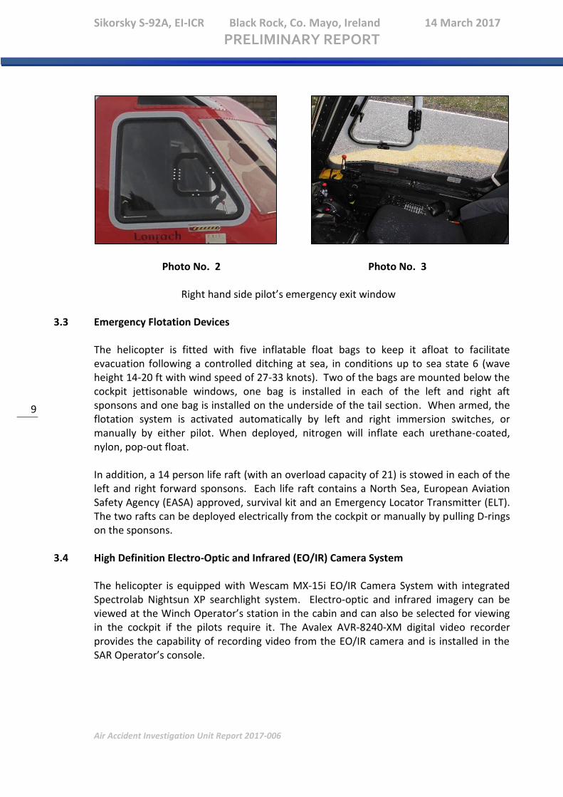
3.2 Emergency Exits In addition to the main sliding door on the right hand side of the cabin and the rear ramp door, three cabin emergency exits are fitted. The three cabin emergency exits can be jettisoned by rotating the interior or exterior release handle. The upper section of the air stair door can be opened by using the locking handle. Pushout cabin windows are also provided. These windows can be jettisoned by pushing on the window from inside the cabin. To facilitate emergency egress from the cockpit, the pilots’ windows can be jettisoned by rotating the interior emergency release handle aft or by pressing the red button and rotating the exterior release handle counter-clockwise (Photo No. 2 and 3).
Sikorsky S-92A, EI-ICR Black Rock, Co. Mayo, Ireland 14 March 2017
PRELIMINARY REPORT
Air Accident Investigation Unit Report 2017-006
9
Photo No. 2 Photo No. 3
Right hand side pilot’s emergency exit window
3.3 Emergency Flotation Devices
The helicopter is fitted with five inflatable float bags to keep it afloat to facilitate evacuation following a controlled ditching at sea, in conditions up to sea state 6 (wave height 14-20 ft with wind speed of 27-33 knots). Two of the bags are mounted below the cockpit jettisonable windows, one bag is installed in each of the left and right aft sponsons and one bag is installed on the underside of the tail section. When armed, the flotation system is activated automatically by left and right immersion switches, or manually by either pilot. When deployed, nitrogen will inflate each urethane-coated, nylon, pop-out float. In addition, a 14 person life raft (with an overload capacity of 21) is stowed in each of the left and right forward sponsons. Each life raft contains a North Sea, European Aviation Safety Agency (EASA) approved, survival kit and an Emergency Locator Transmitter (ELT). The two rafts can be deployed electrically from the cockpit or manually by pulling D-rings on the sponsons.
3.4 High Definition Electro-Optic and Infrared (EO/IR) Camera System The helicopter is equipped with Wescam MX-15i EO/IR Camera System with integrated Spectrolab Nightsun XP searchlight system. Electro-optic and infrared imagery can be viewed at the Winch Operator’s station in the cabin and can also be selected for viewing in the cockpit if the pilots require it. The Avalex AVR-8240-XM digital video recorder provides the capability of recording video from the EO/IR camera and is installed in the SAR Operator’s console.

10
1
10
3.5 Avionics
3.5.1 General
The avionics suite includes, amongst other components, the following systems: • A Universal Navigation UNS-1Esp Flight Management System (FMS) with GPS and
Multi-Missions Management Systems (MMMS) • Dual digital Automatic Flight Control Systems (AFCS) • Dual Attitude Heading Reference Systems (AHRS) • Two Honeywell AA-300 Radio Altimeters (Rad Alt) • Honeywell Primus 701A Airborne, Ground and Sea Mapping Weather Radar System • Honeywell MKXXII Enhanced Ground Proximity Warning System (EGPWS) with
modified software for SAR profiles • Honeywell KTA-970 Traffic Advisory System (TCAS 1) • Emergency Locator Transmitter (ELT) with GPS position broadcast • Automatic Deployable ELT (ADELT) System • Helicopter Emergency Egress Lighting (HEELS) • SAAB Airborne R4A Automatic Identification System (AIS) transponder • Euroavionics EuroNav 5 Moving map display system • Honeywell Primus HF-1050 High Frequency Radio System • ASKNES Aviation Polycon Wireless SAR intercom System • SkyTrac Systems ISAT-100 Flight Following System with CDU and Voice Capability The Rockwell Collins Avionics Management System (AMS) consists of five Multi-Function Displays (MFD), two Mode Select Panels (MSPs) and two Data Concentrator Units (DCUs) (Photo No. 4). DCUs collect and process signals from the Air Data Computer (ADC), the AHRS, the drive train sensors, and the FADEC. Each MFD provides the capability to select between various page formats using fixed function bezel keys located at the top of the display. The available page formats are: Primary Flight Display (PFD), Engine Instrument and Caution Advisory System (EICAS), Navigation (NAV), Health (HLTH), and Utility (UTIL). Sub-formats are selectable by means of buttons located along the bottom of the bezel with soft labels on the display. Sub-formats are as follows: PFD sub-formats – PFD FULL, PFD ARC, PFD CAT A, and PFD Composite; NAV sub-formats – NAV FULL, NAV ARC; HLTH sub-formats – EXBIT, HUMS, Checklists; and UTIL sub-formats – Aircraft Gross Weight, Engine Power Assurance and Configuration.

Sikorsky S-92A, EI-ICR Black Rock, Co. Mayo, Ireland 14 March 2017
PRELIMINARY REPORT
Air Accident Investigation Unit Report 2017-006
11
Photo No. 4: Cockpit Displays and Control Panels
3.5.2 Radio Altimeter Dual Honeywell AA-300 Radio Altimeters (Rad Alt) provide the radio altitude (RA) displayed on the PFDs. Each Rad Alt interfaces with two antennas which are fitted to the bottom of the helicopter and provides the height of the helicopter above the surface whenever it is within 2,500 ft of the surface. The RA is one of the inputs to the AFCS. An analogue Rad Alt is displayed in the upper right corner of the NAV page on the PFD. The analogue gauge disappears when RA is greater than 1,050 ft and reappears when RA is less than 1,000 ft. A digital readout of RA is shown inside the analogue gauge. The digital readout disappears when RA is greater than 2,500 ft and reappears when radio altitude is less than 2,450 ft.
The Display Control Panel (DCP) selected RA setting is shown via a green triangle on the analogue gauge and digitally in green below the gauge labelled RA. There is only one cockpit RA setting that is shown on all PFD and NAV pages. When descending through the RA setting, the “ALTITUDE ALTITUDE” aural alert will be generated once. The digital readout and analogue pointer are yellow when RA is less than the RA setting. The RA hold reference is shown via a magenta bug on the analogue gauge and digitally in magenta below the gauge labelled R ALT. This is only displayed when RA hold is selected.
MFD 1 MFD 2 MFD 5 MFD 3 MFD 4
MSP MSP

12
1
12
3.5.3 Search and Rescue (SAR) AFCS Modes
The AFCS also includes eight SAR modes, which are controlled from either MSP. There are four SAR approach modes, three hover modes and one departure mode. In each approach mode, the helicopter transitions from a high speed, high altitude condition to a low speed, low altitude condition. The approaches attempt to follow programmed deceleration and descent schedules, with decreasing airspeeds corresponding to decreasing radio altitudes. Descent from cruise flight is made with ‘ALT P’ mode, using barometric altitude. Below 2,400 ft, with the RAD ALT active, the SAR approach modes are available. One of these SAR modes, Approach 1 (APP1), automatically transitions the helicopter from flight below 2,400 ft to low level operations. Once initiated, the helicopter will intercept the altitude/airspeed line and continue down 200 ft Above Water Level (AWL) and 80 KIAS ( Figure No. 3). The commanded descent rate is 500 FPM when ‘above the line’ and 200 FPM when ‘on the line’ 14. The commanded deceleration rate is 1.2 knots per second. The helicopter will transition to Radio Altitude Hold (RALT) mode when it reaches 200 ft. The helicopter will transition to Indicated Airspeed Hold (IAS) mode when it reaches 80 KIAS. APP1 uses the pitch channel to decelerate and the collective channel to descend. During APP1, the pilot may also select a heading or Flight Management System (FMS) roll mode. If no roll mode is selected, the helicopter will maintain its current heading. The Cockpit Voice Recorder (CVR) indicates that the Flight Crew selected APP1 during the descent (see Section 5.5).
Figure No. 3: SAR Mode APP1 (APPROACH 1).
14
An ‘on the line’ approach is initiated when the current speed and altitude match the programmed rates.

Sikorsky S-92A, EI-ICR Black Rock, Co. Mayo, Ireland 14 March 2017
PRELIMINARY REPORT
Air Accident Investigation Unit Report 2017-006
13
3.5.4 Enhanced Ground Proximity Warning System (EGPWS)
The EGPWS is designed to decrease instances of Controlled Flight Into Terrain (CFIT) by increasing pilot situational awareness. The EGPWS uses two sets of modes to protect against CFIT. Both sets provide visual and aural alerts when terrain/obstacle clearance is not assured. The basic modes (Modes 2 through 6) are based on RA. The basic modes prevent descent into level or evenly sloping terrain. The enhanced or ‘look ahead’ modes are based on GPS position compared to terrain and obstacle databases. The look ahead modes are intended to prevent the aircraft from running into sharply rising terrain or man-made obstacles. The EGPWS also provides a digital terrain map that allows the pilot to view a representation of terrain and obstacles ahead, provided these are contained in the databases. In addition to the normal EGPWS functions, the S-92A uses the EGPWS as the aircraft aural warning generator. The Investigation notes that the manufacturer’s manual for the EGPWS states “The MK XXII is a Situational Awareness tool, and an alerting and warning device. It is not to be used for navigation of the aircraft.” GPS signals received by the helicopter are processed by the Honeywell MKXXII EGPWS computer to provide both horizontal (lateral) and vertical (altitude) position information. This position in space is then compared to the terrain and obstacle database information contained in the computer to produce a virtual picture which can then be displayed to aid a pilot’s situational awareness. The EGPWS also uses barometric pressure, radio altitude and a special GPS derived altitude called ‘geometric altitude’, using the same Mean Sea Level (MSL) reference as the terrain, obstacle and runway/helipad databases in the system. The EGPWS computer can provide terrain alerting using look-ahead algorithms specifically developed for helicopter operations. The EGPWS uses system inputs, including geographic position, attitude, heading, air-speed, glideslope, landing gear position, and engine parameters. These are used in conjunction with the internal terrain, obstacle, and airport databases to predict potential conflicts between the helicopter flight path and terrain or an obstacle. When a terrain or obstacle conflict is detected, the EGPWS provides a visual and audio alert. A graphic display of the surrounding terrain is displayed on the Electronic Flight Instrumentation System (EFIS) Electronic Horizontal Situation Indicator (EHSI) display. EGPWS modes include: Mode 1, Excessive Rate of Descent; Mode 2, Excessive Terrain Closure; Mode 3, Descent After Take-off; Mode 4A/B, Minimum Terrain Clearance (Approach)15; Mode 4C, Minimum Terrain Clearance, Take-off; Mode 5, Descent Below Glideslope; Mode 6, Altitude Advisories, and Low Altitude modes. Altitude callouts are provided at 500ft and 200ft Above Ground Level (AGL).
15
Mode 4B: When the landing gear is lowered, Mode 4B becomes active and the boundary decreases to 100 ft when above 120 kts. As airspeed decreases below 120 kts the warning boundary decreases to 10 ft at 80 kts. The landing gear was down at the time of the accident.

14
1
14
The EGPWS provides the flight crew (subject to the display selections made) with a display of the helicopter position relative to the databases of surrounding terrain and obstacles. If the EGPWS detects that the helicopter is, or will come into, conflict with database terrain or obstacle(s), it will provide a combination of annunciator lights, colour display(s) and aural alerts to the pilot. Table No. 1 sets out some examples of EGPWS aural alerts for various system modes.
Mode 1: Excessive Descent Rate “SINK RATE” “PULL UP”
Mode 2: Excessive Terrain Closure Rate “TERRAIN TERRAIN” “PULL UP”
Mode 3: Sink after Take-off “DON’T SINK”
Mode 4: Too Close to Terrain “TOO LOW TERRAIN” “TOO LOW GEAR”
Mode 5: Excessive Deviation Below Glideslope “GLIDESLOPE”
Mode 6: Autorotation Altitude Call-outs Bank Angle Tail Strike
“…ONE HUNDRED…” “BANK ANGLE” “TAIL TOO LOW”
Table No. 1 : Examples of EGPWS aural alerts for various modes
In relation to Black Rock and its Lighthouse the EGPWS manufacturer informed the
Investigation that “The lighthouse obstacle is not in the obstacle database and the terrain
of the island is not in our terrain database.” Honeywell explained to the Investigation
that:
“Honeywell’s DO-200A compliant processes include the integration and
validation of multiple data sources, both authoritative (Government and
Type 1 LOA suppliers) and non-authoritative (public and private data). Typical
terrain data sources include remote sensor data (e.g., SRTM, ASTER) as well as
topographical map digitized data. Obstacle data sources include Government
AIP data, supplied by our Type 1 LOA supplier, as well as non-authoritative
data furnished by customers, governments and private industry. Honeywell’s
selected terrain and obstacle source data do not include Black Rock.”
“Honeywell’s terrain data is sourced from our supplier [named supplier]. It is a
digitized topographic map derived data set. It does not include Black Rock. We
have looked at alternate sources, including SRTM and ASTER. While Black Rock
is present in these alternate data sets, the actual altitude of Black Rock is
considerably higher than what is indicated in these alternate data sets. Our
obstacle data for the Ireland region is sourced from our Type 1 LOA supplier,
[named supplier]. This data is originated by the [named source], and does not
include obstacles on Black Rock.”
The Investigation is continuing to engage with Honeywell and other parties/agencies to reach a full understanding of this issue.

Sikorsky S-92A, EI-ICR Black Rock, Co. Mayo, Ireland 14 March 2017
PRELIMINARY REPORT
Air Accident Investigation Unit Report 2017-006
15
3.5.5 Low Altitude Switch
To allow for helicopter operations that require low altitude flight, an EGPWS ‘Low Altitude’ function can be enabled with a switch. This function is designed for flight at low altitude in VFR conditions. When this function is engaged:
• Mode 1 is inhibited • Mode 2 warning boundaries are significantly reduced • Mode 3 warnings are inhibited above 100 ft AGL • Mode 4 warning boundaries are significantly reduced • Mode 6 “ALTITUDE, ALTITUDE” callout is enabled • Terrain Advisory look ahead distances are reduced
CVR data indicates that the Low Altitude Switch was engaged at the time of the accident.
3.5.6 Weather Radar The Honeywell Primus 701A is a high resolution, fully stabilized, high power, airborne, ground and sea mapping weather radar system. It is fully integrated into the cockpit Multi-Function Displays. Weather is presented on PFD ARC and Nav display format pages. Effective Antenna Output power is 10 KW nominal. Horizontal scan angle of 120 degrees or 60 degrees (pilot selectable). Tilt range is +/- 15 degrees, Stabilization is provided for +/- 30 degrees combined pitch, roll, and tilt. It incorporates variable gain. Range is integrated with crew selected on-side range and can be set in discrete steps.
The Primus 701 Weather Radar incorporates a GMAP2 Ground Mapping Mode; the system manufacturer’s manual indicates that this Mode provides the best sensitivity for ground mapping of targets; this Mode disables all ground clutter and sea clutter reduction modes (*CR1 and *CR2 modes).
3.5.7 Moving Map Display
The helicopter was equipped with a EuroAvionics EuroNav 5 moving map display which had a number of maps/charts available for selection. The exact information in relation to Black Rock and Lighthouse varied from none, to detailed, depending on the selected map/chart.
The EuroAvionics digital moving map provides the following functions: • Maps: The full colour EuroNav System features selectable map illustrations. Either
vector or scanned raster maps can be displayed. All map material can be displayed in North-Up or Track-Up modes with the aircraft position placed on the bottom or centre of the screen. The map range can be adjusted by means of the on-side range control. Map labels move with the map but remain upright to enable easy reading in Track-Up mode.
• Terrain Maps: Raster maps based on Digital Terrain Elevation Data (DTED) or other digital terrain data.

16
1
16
• Air Databases: The system also uses proprietary databases showing airspace
structures, topographical airport information like runways, available frequencies, NDB's VOR's and restricted airspace. For the continental US, the following items are displayed: VFR sectional charts, VFR terminal charts, VFR supplements, IFR low level charts, IFR supplements, approach plates for all airports and heliports, special use airways, SIDS and STARs, and IFR supplements.
• Flight Analysis by Flight Recording: Flight recording of flight track and altitude profile can be reviewed or analysed after landing. Events during flight are displayed as a flag in the map. A previous flight track can be used for guidance.
• User Database: Four user databases can be used to store other user defined map data.
3.5.8 Operator’s Route Guide Figure No.4 shows the Operator’s Route Guide for Blacksod (designated ‘APBSS16 (Blacksod South) Route’) which the Crew of R116 was using at the time of the accident. The Route Guide includes an associated separate page of text setting out, inter alia, waypoint designations and coordinates, hazards and obstacles and other general comments. This page identified a lighthouse at Black Rock with an associated height of 310’.
Figure No. 4: Operator’s Route Guide for APBSS
16
APBSS: The Operator informed the Investigation that APBSS stands for ‘Approach Blacksod South’
Sikorsky S-92A, EI-ICR Black Rock, Co. Mayo, Ireland 14 March 2017
PRELIMINARY REPORT
Air Accident Investigation Unit Report 2017-006
17
3.6 Maintenance History
3.6.1 General
Notwithstanding the Daily Check carried out on 13 March 2017, the most recent maintenance inspection was a Zone 4, 50 Hour Inspection, which was performed on 9 March 2017 at 4,848 hours.
3.6.2 Federal Aviation Administration (FAA) Airworthiness Directive 2017-02-51
Following two reports of operators losing tail rotor (TR) control, the FAA issued Airworthiness Directive (AD) 2016-24-51, on 18 November 2016, which was adopted by EASA on 21 November 2016. AD 2016-24-51, applied to S-92A helicopters with a TRPCS assemblies having less than 80 hours time-in-service (TIS), with bearings that were manufactured prior to 3 November 2016.
An Emergency Airworthiness Directive (AD), FAA AD 2017-02-51 was issued on 13 January 2017, and adopted by the European Aviation Safety Agency (EASA) on 16 January 2017. AD 2017-02-51 states that since Emergency AD 2016-24-51 was issued, a third instance of an S-92A helicopter losing TR control was reported, and that a preliminary investigation determined that the bearing failed despite having more than 80 hours TIS. The FAA determined that the unsafe condition could exist on a TRPCS bearing regardless of its TIS. Therefore, Emergency AD 2017-02-51 applied to all TRPCS assemblies. This Emergency AD required a one-time visual inspection and a repetitive borescope inspection of the TRPCS assembly bearing. Maintenance records indicate that the initial action required by the AD was performed on EI-ICR on 14 January 2017. The most recent repetitive inspection was performed on 9 March 2017. No defects were noted.
4 WEATHER
Met Éireann, the Irish Meteorological Service, provided an extract from the Sea Area Forecast Issued at 18.00 hrs on Monday 13 March 2017:
Forecast for Irish coastal waters from Valentia to Erris Head to Malin Head Wind: Southwest force 5 to 7 and gusty, veering southwest to west force 4 to 6 for a time overnight Weather for all Irish coastal waters and the Irish Sea:
Occasional light rain or drizzle. Patchy mist and fog.
Visibility for all Irish coastal waters and the Irish Sea: Moderate to poor in precipitation, mist and fog. Otherwise good.
Warning of heavy swell developing overnight and Tuesday on west and north coasts.

18
1
18
Met Éireann also provided the Investigation with the following aftercast for the Black Rock area:
Report Type Aftercast
Location Area centred at Black Rock, Co. Mayo (18 km west of Blacksod)
Date and Time 14 March 2017 @ 00.45 UTC
Meteorological Situation
Warm sector conditions across Ireland. A cold front orientated NE-SW, situated just to the northwest of the country was moving south-eastwards.
Wind (surface) Southwest 20 kts, gusting 30-35 kts
Wind (2,000 ft) West-southwest 35 kts
Wind (surface-300 ft)
The existing stable warm sector conditions and data received from the Castor Bay sounding suggest that there was a relatively uniform flow, in terms of direction and wind speed, in the vertical between the surface and 300 ft.
Visibility 2-3 km
Weather Mist and drizzle
Cloud Overcast with a cloud base of 300-400 ft
Surface Temp/Dew Pt
10/9 degrees C
MSL Pressure 1025 hPa
Freezing Level 8,000 ft
Sea Surface Temperature
8 to 11 degrees C (Irish coastal waters)
Sea State conditions were forecast to be “very rough becoming high” which equates to a Sea State of 6 to 7.
5 RECORDED DATA
5.1 Flight Recorders
5.1.1 General The helicopter was equipped with a Penny & Giles D-51615-102 Multi-Purpose Flight Recorder (MPFR), which served the dual purpose of CVR and FDR. The MPFR records the most recent 25 hours of flight data and just over two hours of audio data. It then overwrites itself. The MPFR consists of a solid state, crash-protected, non-volatile memory unit, into which is recorded flight data and cockpit audio. In the event of a crash or water landing, a 10 g impact switch or an immersion switch interrupts electrical power to the MPFR which stops it recording.

Sikorsky S-92A, EI-ICR Black Rock, Co. Mayo, Ireland 14 March 2017
PRELIMINARY REPORT
Air Accident Investigation Unit Report 2017-006
19
Attached to the MPFR was an Underwater Locator Beacon which was designed to activate upon immersion in water and transmit an acoustic signal on a frequency of 37.5 kHz for up to 30 days. The signal was first detected by a team from the Irish Marine Institute (see Section 6.3) on 15 March 2017. The signal was subsequently confirmed by an AAIU Inspector of Air Accidents using detection equipment provided by the UK AAIB17. The MPFR was recovered by Irish Naval Service divers on 24 March 2017, 10 days after its immersion.
5.1.2 Data Recovery The MPFR was transported in a bespoke container to the UK AAIB at Farnborough, England, under the escort of an AAIU Inspector of Air Accidents. The recovery process required the disassembly of the MPFR at the UK AAIB laboratory. During the disassembly, some minor external damage was noted on the chassis of the recorder. However, the crash protected memory board containing the CVR and FDR records did not show any signs of physical impact damage. It was noted that water had entered the inside of the crash protected enclosure. Photo No. 5 shows the CVR and FDR memory board following removal. Examination of the memory board showed evidence of corrosion on the contacts of several of the memory devices. Electrical testing revealed short circuits which necessitated additional measures to recover the CVR and FDR recordings. These measures included de-soldering individual memory devices and re-installing them on a functional memory board provided by the manufacturer of the MPFR. The process of validating the data is ongoing.
Photo No. 5: MPFR Memory Board showing water ingress
5.1.3 Cockpit Voice Recorder Information The CVR recorded a total of six audio files from four separate audio channels:
Three separate audio channels (the Commander, Co-Pilot and Rear Crew) from the helicopter intercommunication system for the previous 30 minutes. The Rear Crew channel records audio from both rear crew members on a single track.
17
AAIB: Air Accidents Investigation Branch.

20
1
20
A combined single audio track of the three intercommunication system channels for the previous 120 minutes.
Cockpit Area Microphone for the previous 30 minutes with a bandwidth of 150 Hz to 6 kHz.
Cockpit Area Microphone for the previous 120 minutes with a reduced bandwidth of 150 Hz to 3.5 kHz.
All six channels recorded audio for the flight.
5.1.4 Flight Data Recorder Information
The FDR component of the MPFR on the helicopter can record up to a total of 952 parameters over a period of 25 hours. The MPFR recorded two copies (FDR1 and FDR2) of data to the memory card. The Investigation noted that there was a discrepancy of approximately 20 minutes between FDR1 and FDR2 recording durations. The Investigation is continuing to analyse whether this anomaly resulted from corrosion during immersion in salt water or due to any pre-existing condition. However, initial review of data suggests that the data discrepancy occurred during an earlier recording period prior to the mission of 14 March 2017, and that the final minutes of the accident flight have been accurately recorded on both copies of the FDR data.
5.2 Health and Usage Monitoring System (HUMS)
The helicopter was equipped with a Goodrich HUMS. The HUMS was designed to record the status of critical systems and components on the helicopter so that early detection of progressive defects is possible through trend monitoring, thereby enabling rectification of defects before there is an effect on operational safety or efficiency. In addition the HUMS records a subset of the data which is collected by the FDR. The HUMS system consists of two parts: a HUMS airborne system and a Ground Support Station (GSS). The airborne system consists of a Main Processing Unit (MPU), a Data Transfer Unit (DTU) and a blade-tracking sensor. The airborne system interfaces with Manufacturer-provided sensors (such as accelerometers) and data buses. Display of HUMS prompts or condition information is an integral function of the cockpit multi-function displays. Data is transferred to the Ground Support Station via PCMCIA18 card and/or a serial digital interface The data for R116 was stored on a 256 Mb ATA19 PC Card, which is compatible with the PCMCIA format to facilitate rapid and convenient downloading of data. The HUMS PC Card was recovered by Irish Naval Service divers and subsequently brought to the UK AAIB under the escort of an Inspector of Air Accidents from the AAIU. The card was undamaged and the data, consisting of HUMS data in a format that is proprietary to the manufacturer, and a copy of the FDR data provided from the MPFR, was successfully downloaded. Specific HUMS functions include: 18
PCMCIA: Personal Computer Memory Card International Association. 19
ATA: Advanced Technology Attachment.

Sikorsky S-92A, EI-ICR Black Rock, Co. Mayo, Ireland 14 March 2017
PRELIMINARY REPORT
Air Accident Investigation Unit Report 2017-006
21
Exceedance Monitoring
Drive Shaft Monitoring
Gear box Vibration Monitoring
Gear box Oil Temperature Monitoring
Gear box Chips
Operational Usage, including number of take offs and landings, etc.
Rotor Track & Balance data
Air or Ground Regime Recognition
Component Usage Tracking
Power Assurance - engine power margin data calculated by the engine FADECs An analysis of the HUMS data found that there were no HUMS diagnostic alerts or Flight Manual exceedances recorded.
5.3 Automatic Identification System (AIS) AIS is a transponder system that is operated in Ireland by the IRCG on foot of ‘Directive 2002/59/EC of the European Parliament and of the Council of 27 June 2002 establishing a Community vessel traffic monitoring and information system’. AIS messages are transmitted on two channels in the VHF20 marine band (AIS1 [Channel 87B, 161.975 MHz] and AIS 2 [Channel 88B, 162.025 MHz]). In order to allow many types of AIS equipment to communicate together each unit can only transmit its message at a predetermined time, so that it is not transmitting at the same moment on the same channel as another unit. Each channel is divided into 2,250 equal time slots, that repeat every minute, and the AIS messages are designed to fit into between one and three slots depending on the type of information being sent. The system comprises AIS base stations located at sixteen radio sites around the coast on elevated ground. The data from these base stations feeds into a number of servers, which then deliver data to the IRCG control centres. Various agencies such as the Health Service Executive (HSE) are also provided with this data. Search and Rescue (SAR) helicopters fitted with AIS transponders transmit an AIS SAR message (Message Type 9) every 10 seconds. This message contains details of the helicopter’s unique identifier (MMSI), speed & course over ground, latitude, longitude and altitude (GPS). The IRCG provided the Investigation with a copy of the AIS recorded data from both R116 and R118 for the time of the occurrence. The last message received from R116 was at 00.46:06 hrs on 14 March 2017. AIS Aid to Navigation (AtoN21) messages (Message Type 21) fit into two slots, and are transmitted every 3 minutes. Black Rock AIS transmits on the first minute of the hour, and every three minutes thereafter in Slot numbers 244 and 245 on AIS channel 1, and in slots 827 and 828 on AIS channel 2. This equates to transmission times of 6.5 and 22 seconds past the start of the minute, every third minute on channels 1 and 2 respectively.
20
VHF: Very High Frequency. 21
Aid to Navigation AIS messages are not received by AIS-equipped helicopters.

22
1
22
The monitoring of the lighthouses on Eagle Island, Black Rock and Achillbeg is performed using the AIS. This system sends the status of the light to Central Monitoring System (CMS) at Dun Laoghaire every three minutes, using a VHF radio transmission. Therefore any failure of the light will be notified within a maximum of three minutes. The status of other equipment at the lighthouses is sent to the CMS every six minutes. Blacksod is fitted with a traditional monitoring system, which stores all events that happen and forwards them to the CMS twice daily, over a 3G link, at the scheduled poll time (07.31 hrs and 19.31 hrs). Manual polls of stations can be initiated at any time from Dun Laoghaire, and these manual polls will also transfer the event information to the CMS. If an event occurs at a lighthouse which indicates a failure of some equipment, or out of tolerance parameter, then communications will be immediately established from the lighthouse, and the alarm and any pending events transferred to the CMS. The Commissioners of Irish Lights conducted a review of all data for the light houses at Black Rock, Blacksod, Eagle Island and Achillbeg for the night of the accident. It concluded that the four lighthouses in the vicinity of the R116 accident location were operational over the period of interest; the lights remained on and functioned correctly throughout the period between “light on” on the evening of 13 March 2017 and “light off” on the morning of 14 March 2017. The results of that review are summarised as follows:
Lighthouse Light on Light off
Eagle Island 13/03/2017 18.32:06 14/03/2017 06.59:06
Blacksod 13/03/2017 18.11:47 14/03/2017 07.05:01
Black Rock Mayo 13/03/2017 18.39:22 14/03/2017 06.45:07
Achillbeg 13/03/2017 18.33:09 14/03/2017 07.06:09
All messages recorded on the CMS are time-stamped at source. The Remote telemetry units at the lighthouses synchronise their clocks with the CMS every time that they communicate. The CMS is synchronised to UTC as are the AIS receiving stations that timestamp the AIS messages. Relevant AIS data for R116 and R118 were provided to the Investigation by the IRCG. The Health Service Executive (HSE) National Ambulance Service (NAS) also provided the Investigation with a copy of the AIS recorded data from R116 for the time of the occurrence. The data provided positional information for the helicopter during the mission. The NAS receives the data transmission from the helicopter via the IRCG network of base stations. This allows the National Aeromedical Coordination Centre (NACC) to monitor the location and status of the helicopter during Helicopter Emergency Medical Service (HEMS) missions. During the flight of R116 on 14 March 2017, the NAS received AIS data from the helicopter but did not specifically follow the flight as the mission had not been tasked from the NAS. For the purposes of orientation in this Preliminary Report the Investigation overlaid the AIS track information on “Google Earth” to produce two images showing an overview of the helicopter track (Figure No. 5) in the general Blacksod area and a close up of the final seconds of the track (Figure No. 6) and the terrain of Black Rock.

Sikorsky S-92A, EI-ICR Black Rock, Co. Mayo, Ireland 14 March 2017
PRELIMINARY REPORT
Air Accident Investigation Unit Report 2017-006
23
The last position data from the HUMS card recording of FDR data was used to generate a placemark for what appears to be the last recorded position. However, during the seconds following initial impact the helicopter was subjected to complicated flight dynamics and a progressive deterioration of structural and systems integrity, which may have affected the accuracy of this last position.
Figure No. 5: Overview of helicopter track in the general Blacksod area
Figure No. 6: Final seconds of helicopter track and Black Rock
5.4 FADEC Data The helicopter was powered by two FADEC equipped, General Electric CT7-8A turbo shaft engines. The FADEC boxes which retain basic data on engine operation were recovered by the Investigation. However, the Investigation notes that the FADEC boxes were exposed to salt water and air for a number of days and, consequently, may have experienced an undetermined level of contamination or corrosion.

24
1
24
5.5 Initial Review of Available Data
An initial review of the available data from the CVR, FDR, HUMS, AIS, ATC and Marine Radio communications has established the following factual information:
The Commander for the mission was seated in the right hand side cockpit seat and was the pilot flying. The other pilot, seated in the left hand side cockpit seat, was also a qualified helicopter commander; he was the Co-pilot (Pilot Monitoring) for the flight.
The CVR indicates that crew communications were mission-focused and considered, with minimal extraneous conversation.
The helicopter initially routed towards Sligo on departure from Dublin. Following the completion of inflight fuel and time calculations, the destination was changed to Blacksod Lighthouse for an uplift of fuel prior to a planned routing towards the location of the SAR mission being conducted by R118.
The initial cruise altitude for the flight was 3,000 ft AMSL22. En route the helicopter climbed to 4,000 ft AMSL before crossing mountainous terrain in Co. Mayo.
The Crew made extensive attempts to establish two-way radio communications with R118. Two-way communications were briefly established on secure VHF radio, whilst R118 was in the vicinity of Blacksod for refuelling.
The Commander programmed the “APBSS (Blacksod South) Route” (See Figure No.4 above) into the FMS during the cruise and the Co-pilot confirmed that the route matched the Operator’s Route Guide.
The Commander briefed the Crew on the plan for arrival at Blacksod Lighthouse.
The CVR recorded the Commander commenting to the other Crew Members on a number of occasions that it had been a substantial period of time since she had previously landed in Blacksod. On one occasion the Commander asked the Co-pilot when he had last been into Blacksod and he indicated that he had not been there recently.
The helicopter commenced a descent from its cruising altitude (4,000 ft) when abeam the waypoint BKSDA en-route to the waypoint BLKMO.
The undercarriage was extended and three green lights were indicated during the descent.
22
AMSL: Above Mean Sea Level

Sikorsky S-92A, EI-ICR Black Rock, Co. Mayo, Ireland 14 March 2017
PRELIMINARY REPORT
Air Accident Investigation Unit Report 2017-006
25
The helicopter descended initially to 2,400 ft, whereupon the Commander selected the APP1 mode to establish the helicopter at 200 ft AMSL and 80 kts. Thereafter, the airspeed was manually adjusted to 75 kts due to the Commander’s stated expectation of tailwinds on the easterly leg of the arrival.
The Commander’s stated intent was to complete the APP1 procedure prior to turning east towards waypoint BLKMO to commence the arrival route to Blacksod Lighthouse.
The Commander set the Rad Alt to 180 ft and the auto-hover height to 150 ft.
The Primus 701 Weather Radar was set to the GMAP2 Ground Mapping Mode; the system manufacturer’s manual indicates that this mode provides the best sensitivity for ground mapping of targets. This mode disables all ground clutter and sea clutter reduction modes (*CR1 and *CR2 modes)
A weather radar range of 10 miles was requested by the Commander and the Co-pilot confirmed this selection.
The CVR recording contains no reference by the Crew to the presence of a lighthouse or terrain at Black Rock during their briefing for APBSS.
The LOW ALT switch on the EGPWS was confirmed as ON by the Commander and cross-checked by the Co-pilot.
The Commander had the moving map displayed on her MFD and the Co-pilot had weather radar displayed on his MFD.
The CVR recordings indicated that the Co-pilot was using the weather radar to identify terrain features.
The Rad Alt provided a callout of “ALTITUDE, ALTITUDE” 26 seconds prior to the initial impact. The Commander identified the reason for the aural alert as a small island below the helicopter which she said was “just a small little island… that’s B L M O itself”. At the time of the aural alert FDR data placed the Helicopter in the vicinity of an outcrop of two rocks, Carrickduff and Carrickad, which are located approximately 0.65 nm to the west of the Black Rock.
A rear crew member identified an island, probably through the use of the EO/IR camera, approximately 13 seconds prior to the initial impact with terrain. He said “looking at an island just in, directly ahead of us now guys, you want to come right [Commander’s Name]”.
In response to a query “OK, come right just confirm?” from the Commander, the rear crew member said “twenty degrees right yeah”, and a heading change was initiated using heading mode. The rear crew member then interjected, with increasing urgency, “Come right now come right COME RIGHT”.

26
1
26
The helicopter rapidly pitched nose up during the two seconds prior to the initial impact.
Following the initial impact, the data indicates that the helicopter climbed while experiencing large changes in pitch, roll and yaw angles.
Within two seconds after the initial impact, the three green lights indicating that the undercarriage was down and locked stopped illuminating and the ‘TOO LOW GEAR’ aural alert was triggered.
The Investigation is cognisant that the highly dynamic nature of the helicopter’s departure from controlled flight, the progressive disruption of the helicopter, the unusual attitudes adopted by the helicopter during this time and the limitations of digitally sampled data mean that the parameter values recorded at this time must be treated as indicative rather than definitive.
However, the recorded data indicates that the Flight Crew was using an Operator-specific route guide and the Investigation is of the opinion that a review of the Operator’s Route Guides is warranted. Consequently, a Safety Recommendation is made in that regard (See Section 8).
Appendix A contains an extract of one minute and forty seconds approximately of relevant data from the CVR, from the period immediately prior to the accident. Time values in Appendix A are elapsed times from the start of the recorded audio track. Appendix B shows a plot of a selection of relevant parameters, from the flight data which was recorded on the HUMS card, for the last 11 seconds of the flight. It shows that the helicopter was in stable level flight at 200 ft Radio Altitude, 75 kts Indicated Airspeed, helicopter heading 120 degrees magnetic (approximately) on a track towards waypoint BLKMO. Just as the CVR rear crew channel recorded “Come right now come right COME RIGHT”, the HUMS data showed significant inputs on the cyclic and collective data parameters.
6 WRECKAGE EXAMINATION
6.1 Introduction
Following the accident, debris from the helicopter was found on Black Rock, floating in the sea to the east of the rock and washed up on the shoreline of counties Mayo and Donegal. The main wreckage was found by locating the acoustic beacon attached to the MPFR; it was located in 40 m of water off the southeast side of Black Rock.
6.2 Debris found on Black Rock
The horizontal stabiliser was found on the rock, adjacent to an outhouse which was close to the lighthouse. Tiles on the roof of the outhouse exhibited damage, consistent with being struck by falling debris.

Sikorsky S-92A, EI-ICR Black Rock, Co. Mayo, Ireland 14 March 2017
PRELIMINARY REPORT
Air Accident Investigation Unit Report 2017-006
27
The horizontal stabiliser exhibited significant damage and distress, with damage to the graphite tip and leading edge; it separated from the tail rotor pylon at the root. The trailing edge of the root (approximately 20 inches in length) separated from the main structure. A piece of a leading edge erosion strip from one of the tail rotor blades, one and a half inches in length, which was recovered on the rock, was found to fit into a gouge in the horizontal stabilizer mounting structure. The underside of the mounting structure was scraped and distorted. Fractured sections of the Intermediate Gear Box (IGB) centre housing, including the oil level sensor and a portion of the chip detector, as well as the IGB fairing which was broken into four distinct pieces, were found on the rock. Also recovered from the rock were fractured sections of tail rotor blade; each section was less than two inches long. Two tail rotor control cable pulleys were also recovered, one of which was found on the platform at the top of the lighthouse. In addition, fractured pieces of a wheel rim were recovered close to the helipad.
6.3 Wreckage found on the Sea Bed The approximate position of the helicopter’s MPFR Underwater Locator Beacon (ULB) was identified on 15 March 2017 by the Marine Institute, utilising an Ultra-Short BaseLine (USBL) sub-surface locating device, operated from a boat on the sea’s surface. At the same time, sonar scans of the sea bed were carried out by the Irish Marine Institute supported by Geological Survey (Ireland) to facilitate searches using a Remotely Operated Vehicle (ROV). Subsequently, the signal was confirmed by the AAIU using a hand-held hydrophone. During the first search conducted by the ROV, the main part of the helicopter wreckage was found on the sea bed in approximately 40 m depth of water, off the south east coast of Black Rock. This underwater wreckage included the following:
The cockpit and upper fuselage section was lying on its left hand side/shoulder approximately 135o from vertical, and on a heading of approximately 140o magnetic. The cockpit area was reasonably intact. The nose landing gear was in the extended (down) position. The Electro-Optic and Infrared (EO/IR) ‘ball’ was present below the nose. Both avionics racks were still present and intact in the cockpit entrance area. The MPFR was visible in the left hand avionics rack through a broken access panel. The HUMS unit and its memory card slot were also visible. This section also included the cabin ceiling/upper fuselage, complete with the main transmission to the No. 3 driveshaft; the input modules; the two main engines and their FADEC units, and the Auxiliary Power Unit (APU).
All four main rotor blade roots were observed still attached to the main rotor hub. All the observed sections of main rotor blade exhibited damage. Two of the main rotor blades appeared to be notionally intact from the root to just inside the tip cap.

28
1
28
The cabin floor/lower fuselage had separated from the lower fuselage aft of the nose landing gear area and was lying forward of its normal location.
The right hand Main Landing Gear (MLG) and its sponson had separated from the fuselage. The assembly was found on the sea bed adjacent to the main wreckage.
The Winch Operator’s control console was lying close to the cabin floor section.
A litter structure, and several utility seats were observed in close proximity to the helicopter fuselage
The tail pylon was lying forward (approximately south) of the cockpit. The inner portions of the four tail rotor blades remained attached to the tail rotor gear box which was in situ in the tail pylon. There appeared to be substantial crushing damage to the base of the tail rotor pylon structure. The upper structure of the drive shaft tunnel was observed and was still connected to the tail rotor vertical pylon and tail rotor.
Two separate sections of tail rotor driveshaft were lying close to the main cockpit and upper fuselage/ section.
A section of the upper rear fuselage, where it transitions to the tail pylon, was lying forward (south) of the tail pylon. This section contained the aft float, which was observed to be uninflated. The float cover had detached.
The two cockpit side jettisonable window hatches were found in close proximity to the main wreckage.
The rescue hoist had separated from the helicopter, but was found in the vicinity of the main wreckage.
The fractured and separated base plate of the Automatic Deployable ELT (ADELT) System was located in the vicinity of the main wreckage (Photo No. 6).
Photo No. 6: Fractured and separated base plate from the ADELT

Sikorsky S-92A, EI-ICR Black Rock, Co. Mayo, Ireland 14 March 2017
PRELIMINARY REPORT
Air Accident Investigation Unit Report 2017-006
29
A detailed photographic and High Definition (HD) video survey was conducted by the ROV, before the commencement of recovery operations. The MPFR, the HUMS memory card and the upper section of the fuselage, including the engine FADEC units and the main rotor gear box were recovered from the sea bed. The tail rotor head and attached structure was also recovered.
6.4 Items found on the Sea Surface and on the Shoreline The forward cabin sliding door separated from the structure and was recovered floating in the water. The top sliders were still attached to structure. The door latch and pin exhibited bending. The right hand fuel tank sponson was found floating on the surface, intact, with the forward life raft section attached; the raft was not in its stowed location. When brought to land it was found to still contain a significant quantity of fuel. Various pieces of the left hand fuel tank sponson, which appeared to have shattered, were recovered from the surface; they smelled of fuel. The upper ramp door (cargo hatch) was recovered in the water, separated from the structure. The locking handle was broken and honeycomb structure was visible over the entire length of the left side. The ramp was recovered in the water, separated from the main structure. The left and right ramp pistons separated from the ramp. Approximately six inches of the entire length of the ramp on the left hand side fractured and separated. The right hand wooden skid plate was intact and the left hand skid plate was fractured and separated from the ramp. The APU access panel, whale tail and forward and aft portions of the top deck separated from the structure. The left and right emergency egress exit panels were recovered. The left egress panel buckled and fractured on the upper forward corner. A partially full auxiliary fuel tank was recovered intact with fractures at the lower attachment points. The tail rotor drive cowling (36 inches in length) separated from the drive shaft tunnel and was recovered in the water.
6.5 Observations
The recovered wreckage was laid out and examined at the AAIU’s wreckage examination facility at Gormanston Co. Meath. Based on damage patterns examined during the wreckage layout and observations carried out from the ROV surveys, it appears that the helicopter was in a nose high attitude when it impacted with Black Rock.

30
1
30
7 SURVIVAL EQUIPMENT ICAO Annex 13 requires that survival aspects of an aviation accident are considered as part of the Investigation. At this preliminary stage, the Investigation has not gathered all of the evidence and information required to deal with this matter comprehensively. However, the Investigation identified a matter of concern relating to the installation of the locator beacons in the lifejackets worn by the pilots. The installation appeared to be in accordance with a picture contained in a Service Bulletin issued by the lifejacket manufacturer showing the GPS antenna in the same pouch as the beacon. However, the beacon manufacturer’s publications recommend a minimum separation between beacon and GPS antenna of 30 centimetres (cm). In order to ensure that locator beacons in Mk 44 lifejackets function as expected a Safety Recommendation is issued to the manufacturer of the lifejackets.
8 INTERIM SAFETY RECOMMENDATIONS While the Investigation is still at a preliminary stage, two Interim Safety Recommendations are made. As the Flight Crew was using an Operator-specific route guide it is appropriate that the Operator should review all such route guides. Accordingly, the Investigation recommends that:
Safety Recommendation No. 1 CHC Ireland should review/re-evaluate all route guides in use by its SAR helicopters in Ireland, with a view to enhancing the information provided on obstacle heights and positions, terrain clearance, vertical profile, the positions of waypoints in relation to obstacles and EGPWS database terrain and obstacle limitations.
(IRLD2017005)
Due to the issues outlined in Section 7, the Investigation recommends that:
Safety Recommendation No. 2 RFD Beaufort Ltd should review the viability of the installation provisions and instructions for locator beacons on Mk 44 lifejackets and if necessary amend or update these provisions and instructions taking into consideration the beacon manufacturer’s recommendations for effective operation.
(IRLD2017006)

Sikorsky S-92A, EI-ICR Black Rock, Co. Mayo, Ireland 14 March 2017
PRELIMINARY REPORT
Air Accident Investigation Unit Report 2017-006
31
9 FURTHER INVESTIGATION The Investigation is ongoing and a formal, ICAO Annex 13, Final Report will be published in due course. The Investigation will consider a number of factors including organisation and management of the mission, the Operator’s procedures and guidance, helicopter systems, navigation, mapping & charting, human performance, aircraft performance, survival aspects, ergonomics, oversight, risk management and a deeper analysis of the recorded data and recovered wreckage.

Appendix A Extract of one minute and forty seconds approximately of relevant data from the CVR,
from the period immediately prior to the accident
Elapsed time Commander Co-pilot (PM) Rear Crew Channel Other Source Comment
2.01:27.694 2.01:31.544
Belmullet Coast Guard Radio from Rescue one one six, sixteen
2.01:33.789. 2.01:37.332
Rescue one one six This is Belmullet Coastguard Radio sixteen go ahead
Received transmission on Marine VHF Radio
2.01:38.964 2.01:39.032 2.01:41.622 2.01:41.847 2.01:46.998
[unintelligible] coming left yep slowly coming left
Roger
Roger Belmullet Coast Guard Radio from one one six eh yes we should be landing very shortly now at Blacksod and we’ll call again when airborne, over
2.01:47.291 2.01:48.650
Groundspeed’s gonna start increasing
2.01:49.834 2.01:53.085
That’s all copied, we’ll standby, thanks very much, standing by on sixteen
Received transmission on Marine VHF Radio
2.01:55.479 2.01:57.746
Eh the baro’s a little bit off but we’re on radalt only

Sikorsky S-92A, EI-ICR Black Rock, Co. Mayo, Ireland 14 March 2017
PRELIMINARY REPORT
Air Accident Investigation Unit Report 2017-006
33
Elapsed time Commander Co-pilot (PM) Rear Crew Channel Other Source Comment
2.01:57.935 2.01:58.301
Roger
2.02:13.597 2.02:16.632 2.02:16.857 2.02:19.575
Roger
One point three err miles to run to eh blackmo… and after that its bravo kilo sierra delta alpha
2.02:19.589 2.02:22.981 2.02:22.990
Copied and with you have eh indicated airspeed search and radalt confirmed
Roger

34
1
34
Elapsed time Commander Co-pilot (PM) Rear Crew Channel Other Source Comment
2.02:28.261 2.02:31.234 2.02:31.533 2.02:32.411 2.02:33.561 2.02:33.580 2.02:33.624 2.02:36.184
Roger Eh just a small little island… that’s B L M O itself
OK so small target at six miles eleven o’clock Large out to the right there ehm
ALTITUDE ALTITUDE
Radalt Automated callout
2.02:46.767 2.02:50.417
K…looking at an island just in, directly ahead of us now guys, you want to come right [Commander’s Name]
2.02:50.862 2.02:51.810
OK, come right just confirm?
About…
2.02:52.035 2.02:52.888
twenty degrees right yeah
2.02:53.404 2.02:54.416
OK Come Right…select heading

Sikorsky S-92A, EI-ICR Black Rock, Co. Mayo, Ireland 14 March 2017
PRELIMINARY REPORT
Air Accident Investigation Unit Report 2017-006
35
Elapsed time Commander Co-pilot (PM) Rear Crew Channel Other Source Comment
2.02:55.231 2.02:55.384 2.02:55.691 2.02:56.164 2.02:57.231
Select heading
Roger… Heading selected
2.02:57.691 2.02:59.005
Come right now come right COME RIGHT
2.02:59.097 2.02:59.893 2.03:00.730 2.03:01.198
[Expletive] OOOHHHH [Expletive]
ALTITUDE ALTITUDE
Automated callout Loud noise Automated callout
2.03:01.734 SMOKE IN BAGGAGE Automated callout
2.03:02.557 We’re gone
2.03:03.647 SMOKE IN BAGGAGE Automated callout
2.03:04.305 2.03:05.377
2 Pings Sound of ELT transmission
2.03:05.565
DECOUPLE Automated callout
2.03:06.605 2.03:06.707
Engine note variance
2.03:06.601 2.06:06.959
Unknown sound
2.03:07.109 TOO LOW GEAR Automated callout
2.03:08.526 2.03:08.990
[Short muffled sound]

36
1
36
Elapsed time Commander Co-pilot (PM) Rear Crew Channel Other Source Comment
2.03:09.026 2.03:09.676
TOO LOW GE.. Automated callout cut-off by static noise
2.03:09.676 2.03:09.868
Loud static noise
2.03:09.868 2.03:09.963
Silence
2.03:09.963 Sound similar to that of audio disconnection
2.03:10.168 End of Recording

Sikorsky S-92A, EI-ICR Black Rock, Co. Mayo, Ireland 14 March 2017
PRELIMINARY REPORT
Air Accident Investigation Unit Report 2017-006
37
Appendix B A selection of recorded data from the final seconds of FDR data
- END -

In accordance with Annex 13 to the Convention on International Civil Aviation, Regulation (EU) No. 996/2010, and Statutory Instrument No. 460 of 2009, Air Navigation (Notification and Investigation of Accidents, Serious Incidents and Incidents) Regulation, 2009, the sole purpose of this Investigation is to prevent aviation accidents and serious incidents. It is not the purpose of any such investigation and the associated investigation report to apportion blame or liability.
A safety recommendation shall in no case create a presumption of blame or liability for an
occurrence.
Produced by the Air Accident Investigation Unit
AAIU Reports are available on the Unit website at www.aaiu.ie
Air Accident Investigation Unit, Department of Transport Tourism and Sport, 2nd Floor, Leeson Lane, Dublin 2, Ireland. Telephone: +353 1 604 1293 (24x7): or
+353 1 241 1777 Fax: +353 1 604 1514 Email: [email protected] Web: www.aaiu.ie