Agua Caliente Proposed Solar Energy Zone
26
PREPARED FOR THE ARIZONA SOLAR WORKING GROUP Agua Caliente Proposed Solar Energy Zone Due Diligence Report Ian Dowdy, AICP, MBA A RIZONA W ILDERNESS C OALITION PO B OX 13524 | P HOENIX , AZ, 85003 | (602) 252-5530
Transcript of Agua Caliente Proposed Solar Energy Zone

Agua Caliente Proposed SEZ | FINAL DUE DILIGENCE REPORT | April 9, 2012
P a g e | 1
PREPARED FOR THE ARIZONA SOLAR WORKING GROUP
Agua Caliente Proposed
Solar Energy Zone
Due Diligence Report
Ian Dowdy, AICP, MBA
A R I Z O N A W I L D E R N E S S C O A L I T I O N P O B O X 1 3 5 2 4 | P H O E N I X , A Z , 8 5 0 0 3 | ( 6 0 2 ) 2 5 2 - 5 5 3 0

Agua Caliente Proposed SEZ | FINAL DUE DILIGENCE REPORT | April 9, 2012
P a g e | 2
Note about the Author
Ian Dowdy is a graduate of Arizona State University with a B.S. in Urban Planning and Masters in
Business Administration. His experience in urban planning includes work for the Town of Buckeye
as a planner during the housing boom of the 2000s and as a consultant on a variety of master-
planned communities throughout Maricopa County. Ian has also achieved the American Institute
of Certified Planners (AICP) title administered by the American Planning Association. Among
other principles, the AICP certification represents a commitment to a fair and transparent
planning process and an obligation to retain the public interest as first priority in any project or
action. To learn more about the AICP code of ethics please visit:
http://www.planning.org/ethics/ethicscode.htm.
About the Arizona Solar Working Group (ASWG)
The Arizona Solar Working Group (AZSWG) is composed of a variety of stakeholders representing
non-governmental organizations and the solar industry, including those from the conservation
arena, power utilities, solar developers, and renewable energy interest groups. The purpose of
the group is to work collaboratively toward identifying and resolving potential conflicts between
solar development and land conservation and to provide mutually agreeable comments to the
Restoration Design Energy Project (RDEP) EIS for the Bureau of Land Management.
About the Arizona Wilderness Coalition
The mission of the Arizona Wilderness Coalition (AWC) is to protect and restore wild lands and
waters throughout Arizona. A key component of this mission is to advocate for responsible and
sustainable policies toward a clean energy future without compromising key wildlife habitat and
opportunities for primitive and unconfined recreation. AWC also actively advocates for pragmatic
new conservation measures including appropriate designations for wilderness, National
Conservation Areas, and Wild & Scenic Rivers to ensure a sustainable future for coming
generations of Arizonans. The Arizona Wilderness Act of 1984, Arizona Desert Wilderness Act of
1990, and the Fossil Creek Wild & Scenic River designation of 2009 are among the Arizona
Wilderness Coalition’s many achievements. To learn more please visit www.azwild.org.
Agua Caliente Proposed SEZ | FINAL DUE DILIGENCE REPORT | April 9, 2012
P a g e | 3
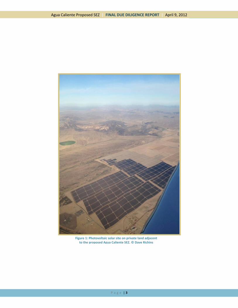
Figure 1: Photovoltaic solar site on private land adjacent to the proposed Agua Caliente SEZ. © Dave Richins

Agua Caliente Proposed SEZ | FINAL DUE DILIGENCE REPORT | April 9, 2012
P a g e | 4
Table of Contents Introduction ................................................................................................................................................................... 5
Background ............................................................................................................................................................... 5
Purpose and Intent .................................................................................................................................................... 5
Methodology ............................................................................................................................................................. 6
The Proposed Agua Caliente SEZ ............................................................................................................................... 6
The RDEP Alternatives: How They Connect to the Aqua Caliente SEZ .................................................................. 7
Summary of Alternatives .................................................................................................................................... 10
Evaluation .................................................................................................................................................................... 10
Site Conditions ........................................................................................................................................................ 10
Environmental ......................................................................................................................................................... 14
Wildlife Habitat ................................................................................................................................................... 14
Historic and Cultural ........................................................................................................................................... 19
Market and Viability ................................................................................................................................................ 19
Proximity to Transmission................................................................................................................................... 20
Proximity to Substation ...................................................................................................................................... 20
Market Potential ................................................................................................................................................. 20
Regulatory Framework ............................................................................................................................................ 20
Planning and Zoning ............................................................................................................................................ 20
Flood Control ...................................................................................................................................................... 23
Evaluation Factors and Recommendations ................................................................................................................. 23
Known Issues of Concern (KIC) ................................................................................................................................ 23
Disconnect Between the Alternatives in the RDEP EIS and the SEZ ................................................................... 24
Overlap with the Palomas Plain Wildlife Habitat Area (WHA) ............................................................................ 24
Conflict with Hunting Community ...................................................................................................................... 24
Citizens Proposed Wilderness (CPW) Issues ....................................................................................................... 24
Recommendations .................................................................................................................................................. 24
Recommendation 1: Conduct a Collective Alternatives Analysis Process within the AZSWG ............................ 24
Recommendation 2: Divorce the SEZ from the REDA Alternatives ................................................................. 25
Recommendation 3: Consideration of Mitigation Opportunities ....................................................................... 25
Conclusion ................................................................................................................................................................... 25
Bibliography ................................................................................................................................................................. 26

Agua Caliente Proposed SEZ | FINAL DUE DILIGENCE REPORT | April 9, 2012
P a g e | 5
Introduction
Background Alternative energy has long been considered a critical component of a sustainable future for the nation. Advocates
have articulated the advantages of having greater energy independence and the environmentally friendly benefits
that wind, solar, geothermal, and biofuels provide. In response to a growing number of applications for renewable
energy development on federal lands, the Bureau of Land Management (BLM) has initiated two processes that will
guide the future of solar energy on Arizona’s public lands. The first is the Programmatic Environmental Impact
Statement for Solar Energy Development in Six Southwestern States (Solar PEIS), which is designed to guide
primarily utility scale projects on BLM lands. The Solar PEIS identifies 3.4 million acres of AZ BLM lands that would
be available for solar development applications, including two Solar Energy Zones (SEZs) totaling 6,500 acres that
would be priority areas for development while “limiting the required scope and effort of additional project-specific
NEPA analyses.”1 The Supplement to the Draft Solar EIS also outlines procedures for identifying new SEZs, which in
Arizona is likely to occur due to their currently limited number and size. The Solar PEIS, aside from its
authorization and protocol for the identification of new SEZs, is outside the scope of this assessment. For more
information regarding the Solar PEIS, please visit www.solareis.anl.gov.
The second solar planning process is unique to Arizona and forms the basis of this assessment. The Restoration
Design Energy Project (RDEP) is intended “to conduct smart, statewide planning to foster environmentally
responsible production of renewable energy and to allow the permitting of future renewable energy development
projects to proceed in a more efficient and standardized manner. The RDEP would amend land use plans to
identify geographic areas best suited for renewable energy, establish land reuse goals, and identify design features
to protect resource values and uses.”2 The project utilizes a wide variety of environmental, archeological,
hydrological and other constraints to screen out areas inappropriate for renewable energy development. RDEP
identifies two major classifications of lands that will be available for development; Renewable Energy
Development Areas (REDAs) which will likely fulfill variance requirements for a subset of lands identified in the
Solar PEIS, and the Agua Caliente SEZ in eastern Yuma County, which is the focus of this assessment report. The
Draft EIS for RDEP provides six alternatives that identify up to 321,500 acres of BLM lands for potential renewable
energy development, including three action alternatives for the
designation of the Agua Caliente SEZ. A wide variety of
stakeholders around the state have looked on the RDEP process
with optimism, hoping that it can both encourage responsible
solar development while limiting most of the conflicts that have
hindered or prevented other projects from coming to fruition.
Purpose and Intent The intent of this report is to evaluate stakeholder perspectives,
opportunities, and constraints regarding the proposed Agua
Caliente Solar Energy Zone (SEZ) and to communicate these
findings to the Arizona Solar Working Group (AZSWG) and
member representatives. Research of the Agua Caliente SEZ was
accomplished by utilizing a diverse range of sources and
interviewing a variety of stakeholders to identify, quantify, and
analyze possible concerns; the goal is to provide a transparent
and thorough understanding of the site conditions and constraints. Information gathered is provided within this
1 Supplement to the Draft Solar PEIS, Chapter 2-20
2 Draft RDEP EIS, Chapter ES-2
Figure 2

Agua Caliente Proposed SEZ | FINAL DUE DILIGENCE REPORT | April 9, 2012
P a g e | 6
report and appendices for thorough examination. Ideally, the critical merits and concerns of the Agua Caliente SEZ
can be understood after reading this document, allowing the Arizona Solar Working Group (AZSWG) to reach a
defensible conclusion regarding the viability of responsible solar development on the subject property.
Methodology A list of important stakeholder groups was compiled with input from the AZSWG and each was approached to
discuss aspects of the proposed Agua Caliente SEZ. The following is a list of those that were solicited for input
although not all returned phone calls or had substantive information to provide. Detailed notes of these
conversations are included in Appendix II.
Stakeholders Contacted Regarding Agua Caliente SEZ Name
Arizona Game and Fish Department Ginger Ritter, Ron Barber, Bill Knowles
Yuma Rod and Gun Club George Reiners
Yuma BLM Field Office David Daniels and Vanessa Briceno
Yuma County Maggie Castro and Paul Melcher
NRG Solar Randy Hickok
APS Gregory Bernosky
Yuma Army Proving Ground Angelica Bharat
Arizona State Land Department Mark Edelman
Yuma Audubon Society Cary Meister
Archaeology Southwest Andy Laurenzi
Trust for Historic Preservation Rebecca Schandler
Air Force Rusty Mitchell
ADWR Scott Miller
Friends of Ironwood NF Chris McVie
Friends of Wildlife Matt Clark
Pacific Gas & Electric First Solar
The Proposed Agua Caliente SEZ The proposed Agua Caliente SEZ is located in eastern Yuma County, approximately 65 miles east-northeast of
Yuma and 45 miles west of Gila Bend. The agricultural area of Hyder is directly adjacent to the east, with the Gila
River located 3.5 miles south of the site (Figure 2). A 290 megawatt solar project owned by NRG Energy on private
lands is virtually surrounded by the proposed SEZ, slated for completion in 2014. This energy is expected to power
225,000 homes at full capacity and is being sold to Pacific Gas and Electric, which serves citizens primarily in
southern California. The proposed SEZ is adjacent to a major transmission corridor that houses the 500MW North
Gila 1 line, which includes a right-of-way for the planned 500MW North Gila 2 line. With a substation completed
to serve the NRG Energy development and the relatively flat nature of the area, the BLM has identified the area as
potentially suitable for additional solar energy development.
As defined by the Solar PEIS, a Solar Energy Zone (SEZ) “is an area with few impediments to utility-scale production
of solar energy where BLM would prioritize solar energy and associated transmission infrastructure development.”
(Bureau of Land Management, 2012, pp. 2-19) Under the criteria laid out in the PEIS, the lands considered for
designation as an SEZ:
Were located near existing transmission with capacity or designated corridors;
Were located near existing roads and other infrastructure;
Generally had a slope of 1 to 2 percent or less;

Agua Caliente Proposed SEZ | FINAL DUE DILIGENCE REPORT | April 9, 2012
P a g e | 7
Contained a large continuous tract of BLM-administered land with a minimum of 2,500 acres;
Had limited known environmental constraints; and
Were near an existing solar development on previously disturbed lands. (Bureau of Land Management, 2012, pp. 2-19)
Based on these criteria, the Agua Caliente area may meet the conditions set by the BLM to be considered as an
SEZ. However, the same strict screening evaluations that informed the Renewable Energy Development Areas
(REDAs) established by the RDEP have not informed the selection of the Agua Caliente SEZ. The EIS, on page 2-3
outlines how the SEZ was selected, and implies that the process was separate from Maximum REDA3 (Alternative
1). The SEZ clearly conflicts with at least one of the screening criteria that would have prevented portions of the
site, at a minimum, from being designated as REDA lands. For this reason, additional care must be taken to
consider potential environmental, social, and regulatory constraints that may screen similar sites under the RDEP.
It is important to know that projects in the SEZ will be “required to follow the requirements of the Solar Energy
Program from the Solar PEIS and management actions, design features, and BMPs (Best Management Practices)
noted in Section 2.3.2, Elements Common to All Action Alternatives.” (Bureau of Land Management, 2012, pp. 2-
20) Under these conditions, although the site may not be screened in the standardized manner that REDAs were,
it will have similar management prescriptions to other lands identified in this EIS.
There are a total of seven alternatives provided in the RDEP Draft EIS, two of which do not authorize the proposed
Agua Caliente SEZ; the No Action Alternative and Alternative 5. The Agua Caliente SEZ is under consideration in
the EIS in three configurations: Alternative 1 and 4 have the same footprint as does Alternative 2 and 6. The
smallest footprint is under consideration only in Alternative 3 (Figure 3). Concerns discovered during this
evaluation process may pertain only to certain portions of the total SEZ footprint, in which case alternatives may
distinguish themselves from others as a preferred footprint that achieves the goal of limiting real or perceived
impacts on critical resources.
The RDEP Alternatives: How They Connect to the Aqua Caliente SEZ
It is unclear how the specific constraints of the proposed Agua Caliente SEZ will factor into the selection of an
alternative under the EIS. Unfortunately, there seems to be no clear tie between the footprint of the SEZ
boundaries and the REDA alternative to which it is married. More discussion of this point will covered in the next
section. The way things stand in the EIS, the SEZ configuration will be selected based upon the merits of the RDEP
alternative it accompanies, requiring two separate analyses: that of the SEZ and consideration of the RDEP
alternative. What is unclear is whether significant concerns regarding any one of the configurations of the SEZ will
derail an EIS alternative that has high merits in other respects. As an example, the EIS alternative 6 may distinguish
itself as the best choice for REDA lands but it will also authorize the development of 6,770 acres of land in the SEZ
where the smaller footprint of 2,760 acres may be preferable. Unless separated, major concerns regarding the SEZ
may either derail the best REDA choice or go unresolved if a problematic alternative is ultimately selected.
A brief analysis of the SEZ footprints reveals that Alternatives 1 and 4 have the largest footprint, consisting of
20,600 acres—although it is unlikely that all of this acreage will be fully developed. The presence of braided
washes and mitigation for other site features will likely be accounted for in the site design, resulting in actual
ground disturbance of a subset of the property. Clearly however, if the entire 20,600 acres are subject to
development, its value for recreation, wildlife habitat, and other uses common to BLM lands will be vastly
changed. The exact nature and extent of this change is impossible to know at this time but Alternatives 1 and 4
clearly allow the largest potential impact to the site as a whole.
3 In conversations with Kathy Pedrick of the Arizona BLM office after the development of this report, she stated that the BLM
intended for the SEZ and REDA processes to be separate and that they tried to make that point clear in the EIS.

Agua Caliente Proposed SEZ | FINAL DUE DILIGENCE REPORT | April 9, 2012
P a g e | 8
Figure 3 (Bureau of Land Management, 2012, pp. 2-6)

Agua Caliente Proposed SEZ | FINAL DUE DILIGENCE REPORT | April 9, 2012
P a g e | 9
The footprint for Alternatives 2 and 6 is significantly smaller than that for 1 and 4; it encompasses only 6,770 acres,
including lesser impacts to resources on the ground. Although smaller in size, there are still significant impacts to
washes and other site features that are not avoided by the diminished boundaries. Similarly, Alternative 3, though
the smallest at only 2,760 acres, fails to avoid all washes and natural features, although it does focus development
adjacent to the NRG Energy project on private lands. Brief summaries of each alternative are provided below.
No Action Alternative
This alternative does not identify any land for designation as an SEZ. Under this alternative the BLM lands around
Agua Caliente will be subject to existing rules as established by the Solar PEIS and Yuma Resource Management
Plan. Under these terms, applications for development may be considered in this area even if a SEZ is not
administered. (Bureau of Land Management, 2012, pp. 2-7)
Alternative 1: Maximum REDA
Under this alternative, 20,600 acres will be withdrawn from multiple uses and made available for development.
There is no explanation of how the size and configuration of the Agua Caliente SEZ boundaries relate to other
aspects of the REDA lands except that they are described as the largest possible area for development. (Bureau of
Land Management, 2012, pp. 2-20)
Alternative 2: Transmission Line and Utility Corridor REDA
The boundaries of the SEZ have been scaled back to encompass 6,770 acres in this alternative to comply with the
theme of close proximity to existing utility and transmission infrastructure and other renewable projects. Both the
NRG Energy project and transmission lines are near the boundaries of this alternative. (Bureau of Land
Management, 2012, pp. 2-23)
Alternative 3: Load Offset REDA
With the stated purpose of limiting environmental impacts and disturbance, there is some logical connection
between the reduced footprint and other aspects of the alternative. The SEZ is further scaled back to 2,760 acres
to match other lands situated in similar proximity and orientation to load and transmission infrastructure. (Bureau
of Land Management, 2012, pp. 2-27)
Alternative 4: Water Conservation and Protection REDA
The lands included in the SEZ in this alternative do not clearly relate to other aspects of the RDEP alternative. In
fact, other lands proximate to the SEZ are screened out and are not included as potential REDA lands. For reasons
that are not entirely clear, the SEZ is proposed as the same size as Alternative 1: 20,600 acres. (Bureau of Land
Management, 2012, pp. 2-33)
Alternative 5: Land Tenure REDA
The Agua Caliente SEZ is not a part of this alternative as
it focuses on lands subject to disposal. (Bureau of Land
Management, 2012, pp. 2-36)
Alternative 6: Collaborative-Based REDA
(Preferred Alternative)
This alternative develops REDA based upon a blend of the other alternatives, including input from a variety of
stakeholders. As for the Agua Caliente SEZ, it is based upon the Alternative 2 size and configuration as it “would
meet all of the listed selection criteria noted previously under Alternative 1, but concentrates the development
into a smaller footprint.” (Bureau of Land Management, 2012, pp. 2-37) Again, like Alternative 4, all other BLM
lands in the vicinity of the proposed SEZ have been screened out, raising issues regarding why this footprint should
remain in this alternative.
Known Issue of Concern: Why is the SEZ
proposed in certain alternatives when
other proximate lands have been
screened out? Is this level of
disjointedness acceptable or should the
SEZ be segregated into its own
alternative?

Agua Caliente Proposed SEZ | FINAL DUE DILIGENCE REPORT | April 9, 2012
P a g e | 10
Summary of Alternatives
In short, there are three action alternatives for the proposed Agua Caliente SEZ: 2,760 acres, 6,770 acres, and
20,600 acres. Although some attempt has been made to make the decisions for this aspect of the RDEP
correspond to the REDA analysis, there seems to be a large disconnect primarily due to the fact that the SEZ is not
measured with the same exclusion criteria that apply to the REDA lands—including lands with wilderness character
that are not managed to protect these resources. It may be that a different combination of SEZ and REDA lands
than those listed in the EIS; could be assembled for the best possible alternative.4
Evaluation
Site Conditions The proposed Agua Caliente SEZ is composed of lands that fall within the Lower Colorado Subdivision of Sonoran
Desertscrub vegetation community.5 The site consists primarily of a creosote-bursage plant community with
frequent braided washes of denser xeroriparian vegetation including palo verde, mesquite, and ironwood trees.
Large arroyo complexes stream through the site from north to south as part of the Palomas Plain, draining a large
expanse of land reaching 40 miles northward to the Little Horn Mountains, the source of the majority of alluvium
that covers the site. Hoodoo and Baragan washes are the largest of these, separated by smaller drainages in
between. To the north rests Baragan Mountain, a rocky outcrop comprising the only significant topography north
of the site. To the west stand the Palomas Mountains, which are the first in a number of low mountains leading
into the Yuma Army Proving Ground. To the east lie a number of fallow agricultural fields, many of which have
been cultivated for jojoba beans before being vacated. To the south lies the Southern Pacific railroad right-of-way,
4 Kathy Pedrick of the Arizona BLM office suggests that this approach: to look at the SEZ as a separate process and develop a
different set of alternatives, would be appropriate. 5 Brown, D.E. & C.H. Lowe. 1981. Biotic Communities of the Southwest. Gen. Tech.
Rep. RM 78, U. S. D. A. Forest Service, Fort Collins, CO.
Figure 4: Aerial view of the Agua Caliente SEZ and surrounding lands. (Yuma County GIS, 2012)

Agua Caliente Proposed SEZ | FINAL DUE DILIGENCE REPORT | April 9, 2012
P a g e | 11
which is currently not in operation. Along the railroad are the North Gila 1 500kv transmission line and the
planned North Gila 2 500kv line, directly adjacent. (See Figure 4) Approximately five miles south of the SEZ lies the
Gila River, which receives intermittent flows from property north of the site through the washes that traverse the
proposed SEZ. Lands managed by the Arizona State Land department rest almost directly in the middle of the site,
creating a large swath from north to south from Baragan Mountain down to the railroad track. (See Figure 1)
A site visit was performed on March 1, 2012, to
understand the context of the land and the opportunities
and constraints that may be present. In general there are
several access points that consist of rough dirt roads
requiring a high clearance vehicle. The Palomas-
Harquahala Road is the most popular, connecting Hyder
Road to lands due north of the proposed SEZ.
Additionally there are other routes on the east, west, and
north of the site that provide access to hunters, wildlife
watchers, and other users of the property. The route
traveled for the site evaluation is shown in Figure 6.
The site visit began from the western edge of the site
along the Hoodoo Wash, which extends north and around
the eastern edge of the Palomas Mountains. East of the
wash, the development of the NRG Agua Caliente
development on private lands known as White Wing
Ranch was visible (See Figure 5). The proximity of this
project, though nearly surrounded by the BLM lands in
the SEZ, is not a significant visual impact because the
photovoltaic (PV) panels lie relatively low to the ground.
The view to the west of this point shows a much more striking view of the Palomas Mountains (Figure 7), which
demonstrates some of the scenic qualities the site contains.
Figure 5: Site Assessment Route
Figure 5: Photo 3, East
Figure 7: Photo 4, West
Figure 8: Photo 12, Road in Hoodoo Wash, Northeast
Figure 6: Site Assessment Route

Agua Caliente Proposed SEZ | FINAL DUE DILIGENCE REPORT | April 9, 2012
P a g e | 12
As is seen in the foreground of Figure 9, the surface of
the ground is made up of a unique volcanic alluvium that
supports little flora growth. Despite the lack of
vegetation, the assessment team did not document
previous blading or development on this site. However,
there is obvious and frequent use of off-highway vehicles
(OHVs) in the region. Figure 9 shows the usual character
of this rocky surface between washes.
The quality of the landscape in the Agua Caliente area is
fairly unique, containing a surface of dark volcanic gravel
and little vegetation, save for within frequent braided
washes. While vegetation in the rocky flats between
washes is sparse, the washes seem to be incredibly dense
with stands of palo verde, mesquite, and ironwood along with a wide variety of grasses and brush. (Figure 8)
Variation in topography is considerable over much of the site due to the size of Bargan and Hodoo arroyos and
their smaller tributaries. Major washes vary in depth from 4 to 10 feet below the grade of the surrounding land,
with tributaries to the major washes ranging from 4 to 6 feet of elevation difference. Because of the high density
of washes across the site, significant grading may be necessary to accommodate future solar development.
Figure 10: A view of Baragan wash showing the general character of the site. (Yuma County GIS, 2012)
Figure 9: Photo 60, South

Agua Caliente Proposed SEZ | FINAL DUE DILIGENCE REPORT | April 9, 2012
P a g e | 13
Members of the Yuma BLM office attended the site visit, including Dave Daniels and Vanessa Briceno, as well as
Lane Cowger from the state office. Daniels is a self-described hunter who frequents the area and pointed out signs
of frequent mule deer habitation, including antler scrapings, tracks, and trails that were often found in and around
the washes. He also led the group up on a rocky outcropping on the edge of the SEZ and pointed to what appears
to be signs of early human habitation, including a rock blind and a mortar hole. (Figures 11 and 12) The presence
of these artifacts may be due to the fact that the proposed SEZ is in close proximity to the Gila River, Sears Point,
and many known Native American cultural sites. These types of artifacts however, though interesting, do not
serve as an indicator of the type or quality of cultural value that may be present in the area, and a further
assessment will be needed before reaching any conclusions regarding the relative archaeological value of the site.
This issue is discussed further in the historic and cultural resources section of this report.
The site visit revealed that the Agua Caliente area has high values for mule deer habitat, unique surface geology,
frequent and highly vegetated desert washes, moderate scenic character, obvious signs of OHV use, relatively
complex topography and potential archaeological resources. While adjacent to an existing solar development
project, the lands contained within the Aqua Caliente SEZ remain in a natural condition with at least moderate
natural and cultural values. Specific aspects of the site visit are addressed in the following sections. A complete
catalog of photos from the site visit is attached in Appendix I.
Figure 12: Photo 14, Possible Rock Blind Figure 11: Photo 15, Possible Mortar Hole
Baragan Mountain from across the proposed Agua Caliente SEZ.

Agua Caliente Proposed SEZ | FINAL DUE DILIGENCE REPORT | April 9, 2012
P a g e | 14
Photo 66, View from Baragan Mountain Looking South
Environmental Although REDA lands in the Draft EIS have been screened for the presence of a variety of environmental and
ecological criteria, the proposed Agua Caliente SEZ has not been evaluated to the same extent. If the same criteria
for screening REDA lands were used for identification of the Aqua Caliente SEZ, a much smaller footprint would
presented; although the exact boundaries are difficult to determine at this time. At a minimum, lands with
wilderness character that are not being managed to protect these attributes would not be in the SEZ. (See Figure
16) In order to develop a thorough understanding of the potential environmental conflicts that may exist in the
area of the proposed SEZ, the following have been considered in this report: ecological values including vegetation,
wildlife habitat including big game and special status species, water availability, and potential for historic and
cultural significance.
Wildlife Habitat
Given that the vegetation community of the proposed
SEZ resembles the millions of acres of creosote flats
common to the Lower Colorado River Subdivision of the
Sonoran Desert, the significance of this area rests in its
unique location and character. As a major component of the lower Palomas Plain, the site is contained within an
area described to be “the largest unfragmented habitat in southwest Arizona for a myriad of wildlife, including
bighorn sheep and mule deer. It contains braided channel floodplains and mixed cacti-palo verde communities on
rocky slopes and bajadas”. (BLM Yuma Field Office, 2010) While the vegetation communities do not appear to be
Known Issue of Concern: Conflict with
the Palomas Plain Wildlife Habitat Area

Agua Caliente Proposed SEZ | FINAL DUE DILIGENCE REPORT | April 9, 2012
P a g e | 15
unique or particularly rare, the frequency and prominence of the braided desert washes that traverse the
landscape is somewhat more significant. (Figure 13)
Figure 13: Large Desert Washes and the Gila River
While the flat lands between the washes
contain limited vegetation for forage and
thermal cover, the washes themselves provide
these attributes as well as important
connections to the Gila River to the south (Pat
Barber, 2012). While there is evidence of
human activity in the area, it is generally
restricted to the flat and rocky areas around the
washes that have the least ecological value,
leaving intact the major components that are of
most importance. During the assessment
interview, the Arizona Game and Fish
Department suggested that solar development
in the SEZ may be mitigated if it did not disturb
major washes while retaining a wide corridor to
preserve wildlife movement. Some studies
indicate that this corridor may need to be as Figure 14: Priority Wildlife Corridors (Ritter, 2012)

Agua Caliente Proposed SEZ | FINAL DUE DILIGENCE REPORT | April 9, 2012
P a g e | 16
much as 1 km wide (3,280 ft), which may be a barrier to successful development. (Ritter, 2012) The AZGFD has
identified two major washes that they consider important for wildlife connectivity as shown in Figure 14. These
corridors follow the Baragan and Hoodoo ephemeral streams and are approximately 1 km wide. For these
reasons, the parcel on the east side of the SEZ, comprising about 8,000 acres, was the alternative proposed by
AZGFD in their agency comments prior to the release of the EIS.
Another issue of concern raised by a variety of sources, including the BLM Yuma Field Office (YFO) is that the
proposed SEZ is within the Palomas Plain Wildlife Habitat Area (WHA) which is a BLM management designation
intended to maintain important wildlife habitat, in this case primarily mule deer. As such, the location of the
proposed SEZ conflicts with the management scheme provided by the YFO RMP, which states a goal to
“concentrate developments such as utility facilities in areas already developed or disturbed in the Palomas Plain
WHA.” (BLM Yuma Field Office, 2010, pp. 2-70)
Game Species Habitat
The most prevelant concern voiced by the community in and around Gila Bend was the value of the area around
the proposed Agua Caliente SEZ for mule deer habitat. George Reiners of the Yuma Valley Rod and Gun Club
(YVRGC) was passionate about the value that hunters
place upon this area. In his mind, there is no better
place in the Yuma area to hunt for mule deer. (Reiners,
2012) That opinion was seconded by Dave Daniels of
the BLM YFO, who characterized the site as being the
“backyard of Yuma.” (Daniels, 2012) Additionally the Planning Director of Yuma County, Paul Melcher, attested to
his frequenting the area for bird hunting. (Maggie Castro P. M., 2012) When asked about the overall value of the
area for big game, Pat Barber of the Arizona Game and Fish Department (AZGFD) acknowledged the area’s
popularity, noting that the site was likely the most controversial area to place solar development in the Yuma
region.
An additional concern was raised by YVRGC regarding the overall health of the mule deer population in the Yuma
region. They believe the mule deer herd is in decline and that a significant factor is habitat fragmentation and loss
due to development. The AZGFD recognizes a decline in the mule deer population in the recent publication “Hunt
2011,” which is intended to provide information to the general public on popular game species:
Deer permit numbers gradually increased after 1972, leveling off at around 70,000 per year
between 1976 and 1982, when hunters took more than 12,000 mule deer, approximately 75
percent of the total deer harvest. Then, a series of wet winters resulted in an increase in fawn
survival rates, and hunter numbers and the numbers of deer bagged increased accordingly until
1986, when nearly 86,000 hunters took 25,566 deer, of which 77 percent were mule deer.
Since then, another series of droughts has occurred, and deer hunting opportunity is again being
curtailed. In 2009, 45,037 hunters (for draw hunts) reported taking fewer than 8,700 deer. Of the
total deer harvested that year only 60 percent were mule deer. Prospects in the near future are
even more discouraging, but mule deer are “boom and bust” animals. With the advent of better
than average winter rains, mule deer populations will once again improve. The only question is
when. (Arizona Game and Fish Department, 2011)
In a follow-up conversation with Bill Knowles of the AZGFD Yuma Field Office, he corroborated the position that
drought is the primary factor affecting the mule deer population. He cited a lack of historical evidence that habitat
loss, even to the extent of the proposed SEZ (20,600 acres), negatively impacts mule deer in the area. He noted
that should the SEZ go forward, it would be an important test case for how such large tracts of land, when
developed, may affect mule deer populations. (Knowles, 2012)
Known Issue of Concern: Important Area
for the Hunting Community

Agua Caliente Proposed SEZ | FINAL DUE DILIGENCE REPORT | April 9, 2012
P a g e | 17
Special Status Species
There are several special status species that have
current or historical ranges within the footprint
of the proposed SEZ. They include:
Sonoran desert tortoise (Candidate for ESA listing)
Sonoran pronghorn antelope (federally listed as Endangered)
Burrowing owl (listed as Sensitive by the BLM)
Yuman fringe-toed lizard (listed as Sensitive by BLM and a Wildlife of Special Concern by AZGFD) The only known concerns regarding habitat of these species and the proposed SEZ footprint include the following:
Sonoran Desert Tortoise
The Sonoran desert tortoise is currently listed as
a “candidate” under the Endangered Species Act.
According to the AZGFD, there is no significant
conflict with Sonoran desert tortoise habitat in
the vicinity of the Agua Caliente SEZ. Ginger
Ritter noted only one verified tortoise sighting
within five miles of the proposed SEZ which
occurred in 1979. According to the Yuma
Resource Management Plan, the tortoise may utilize areas near the site and BLM has categorized certain areas,
including the Palomas Mountains and Baragan Mountain, as Tortoise Category III habitat. (Figure 15) This level is a
lower protection zone than categories I and II and has few management actions listed in the RMP. It is unlikely
that the animals will be frequenting the flat areas of the site as they tend to prefer hillsides and bajadas. (Daniels,
2012)
Sonoran Pronghorn Antelope
The Sonoran pronghorn is federally listed as Endangered with a current range within and around the Kofa and
Cabeza Prieta National Wildlife Refuges. The Kofa National Wildlife Refuge experimental population has recently
been released into an enclosure, which is approximately 25 miles northwest of the proposed Agua Caliente SEZ.
(Daniels, 2012) The historical and potentially future range of the species will include the land in and around the
proposed SEZ. AZGFD notes that this site will likely not have any significant bearing on the success of the
introduction program as it is relatively small compared to the possible habitat area of this population, which could
extend from the Colorado River to MC-85 and from I-8 north to I-10. (Pat Barber, 2012)
In summary, species of environmental concern–Sonoran pronghorn and Sonoran desert tortoise—may be
impacted by development in the proposed Agua Caliente SEZ. However, although both species may utilize the
area for habitat, their reliance on the site for critical resources and survival is difficult to ascertain.
Citizens Proposed Wilderness
For decades, a variety of conservation groups have worked throughout the West to conserve wilderness quality
lands across the public domain. These areas are special due to their unique character, remoteness, opportunities
Figure 15: BLM Desert Tortoise Habitat

Agua Caliente Proposed SEZ | FINAL DUE DILIGENCE REPORT | April 9, 2012
P a g e | 18
for primitive or unconfined recreation, ecological value, and a variety of other criteria that may qualify them for
protection under the 1964 Wilderness Act. To date there are nearly 6 million acres of Citizens Proposed
Wilderness (CPW) lands identified across Arizona. Groups such as AWC, The Wilderness Society (TWS), the Sierra
Club, and others advocate for the designation of these areas by Congress as well as their protection through land
planning processes. The BLM is required to inventory and assess Lands with Wilderness Characteristics during the
revision of Resource Management Plans or in a timely manner that allows the agency to decide how those lands
will or will not be managed to retain their wilderness character.
Figure 16: Conflict between CPW Lands and the Proposed Agua Caliente SEZ

Agua Caliente Proposed SEZ | FINAL DUE DILIGENCE REPORT | April 9, 2012
P a g e | 19
When the Yuma RMP was under consideration in 2005, AWC, partner groups, and members of the public provided
the BLM with an inventory identifying lands with wilderness character, requesting that it manage the land to
protect the those characteristics.. Overall, AWC provided data that included 317,000 acres of wilderness quality
land in 22 separate units. The BLM included two areas covering 48,400 acres for protection of wilderness
character: lands just to the west of the Eagletail Mountains Wilderness and the Palomas Mountains just to the
west of the proposed Agua Caliente SEZ. (BLM Yuma Field Office, 2010, pp. 2-139) Nearly all of the other CPW
lands were recognized as having wilderness character but were not prescribed for management that would protect
those values by the BLM. Many conservation organizations believe these places are unique and increasingly
valuable in a quickly growing state like Arizona, and continue to advocate that these 22 areas in the Yuma district
be protected for their wilderness qualities.
Figure 16 shows the boundaries of the proposed Agua Caliente SEZ relative to CPW lands in the area. As is evident,
these areas will be severely impacted should they be developed, resulting in a total loss of the characteristics that
qualify them for wilderness protection. The Palomas Mountains CPW is partially being managed by the BLM to
protect wilderness character, although lands in and
around Hoodoo Wash are not. Lands being managed to
protect wilderness character are not in the proposed
SEZ, although there is significant overlap between other
CPW lands and the SEZ. Conservation groups
responded to the recent Quartzite solar project EIS, which also proposed development in a CPW. Although the
groups did not oppose the project, they requested that the Yuma BLM office manage additional lands in the
district to protect wilderness character as mitigation for the values lost by the development. In general however, it
is the position of many conservation groups that CPW lands be developed only as a last resort because they
contain qualities that are irreplaceable and increasingly rare.
Water Availability
Water availability is often a critical issue for successful solar projects, especially wet-cooled alternatives which may
use up to 90% more water than a comparable dry-cooled technology or photovoltaic generation. In this area,
ground water will need to be pumped to meet any water needs on development projects. In general, the Arizona
Department of Water Resources (ADWR) is tasked with managing water use and permitting in the state, especially
in areas that have been designated for active management (AMAs). Active Management Areas are identified
throughout the state and have strict rules for water use and permitting for projects. According to Scott Miller of
ADWR, the proposed Agua Caliente SEZ is outside of any AMA and is not subject to permitting and water use
regulation by ADWR. (Miller, 2012) It is likely however, that water use will still be a significant issue raised by the
Arizona Corporation Commission and Line Siting Committee in the approval process. (Miller, 2012)
Historic and Cultural
As outlined in the EIS, a Class III cultural resource survey has not been completed on this site and therefore, no
cultural resources have been documented in this area. Andy Laurenzi of Archaeology Southwest has inspected the
AZSITE records and has concluded that “nothing in the existing data suggests that the proposed areas should be
avoided.” (Laurenzi, 2012) The proposed Agua Caliente SEZ is proximate to significant cultural resources near the
Gila River, approximately five miles to the south, but development poses no known conflicts to these resources.
Market and Viability This evaluation of the Agua Caliente SEZ considers three aspects in a very general way: proximity of the site to
transmission, proximity to a substation, and market potential. The analysis provided barely scratches the surface
of a very complex and dynamic issue. Further consideration will be necessary before the true viability of solar
development on the proposed Agua Caliente SEZ can be known.
Known Issue of Concern: Overlap with
Citizens Proposed Wilderness (CPW)
Areas

Agua Caliente Proposed SEZ | FINAL DUE DILIGENCE REPORT | April 9, 2012
P a g e | 20
Proximity to Transmission
Based on conversations with Gregory Bernosky with Arizona Public Service (APS), the North Gila 1 line is in
operation just to the south of the proposed Agua Caliente SEZ but is fully subscribed for energy travelling west to
the Yuma area. The NRG and First Solar project currently under development on the private land adjacent to the
proposed SEZ, known as White Wing Ranch, is connecting to this existing 500kv line. A parallel line known as
North Gila 2, a planned 500kv transmission line, is approved and may come into operation in or around 2015.
North Gila 2 may have available capacity for solar projects attempting to sell power to California through the Yuma
area. There is likely available capacity for power to be delivered to the Phoenix market on both the North Gila 1
and North Gila 2 lines. (Bernosky, 2012)
Proximity to Substation
There is a substation currently serving the nearby NRG and First Solar project at White Wing Ranch that is
connecting to the North Gila 1 line. (Bureau of Land Management, 2012)
Market Potential
Market potential for solar energy is a difficult issue to quantify. It appears that the market in Arizona is not
demanding significant renewable energy development with the relatively low Renewable Portfolio Standard (RPS)
of just 15% by 2025; whereas California has a much more rigorous goal of 33% by 2020. Generally, most of those
interviewed about the issue, expect that unless Arizona increases its RPS significantly, the majority of demand for
electricity from utility-scale solar development will be from California. Tom Wray, of Southwestern Power and
project manager of the SunZia proposed power transmission line, believes that under current conditions, utility-
scale solar projects will only occur if the power is delivered to California. The largest utility in Arizona, APS, has
already contracted all of its renewable energy to meet the goal of doubling their RPS commitment of 5%
renewable power by 2015. They do not expect to purchase renewable energy from the Yuma region in the
foreseeable future. (Bernosky, 2012) Until there is adequate transmission infrastructure to move the power to
California, the most likely destination for electricity, large utility-scale solar projects in the Agua Caliente area
appears to be unlikely.
Regulatory Framework As with any development, there is significant oversight by a variety of governmental agencies including local, state,
and federal entities. In addition to business factors, solar projects on BLM lands must gain approval from the
federal government for a right-of-way, the Arizona Corporation Commission and Line Siting Committee, and local
agencies for development approval. While the federal and state processes are fairly consistent and predicable,
developers have found that local governments can present a fairly substantial barrier because their permitting
requirements vary significantly from place to place, even within the same jurisdiction. The following describes the
level of regulation that may be expected if a project is proposed in the Agua Caliente area.
Planning and Zoning
The proposed Agua Caliente SEZ is within the jurisdiction of Yuma County and is not currently being considered for
annexation or incorporation, nor is it within the planning area of any municipality. Even in the case where the land
is owned by the federal government, Yuma County would maintain jurisdiction over development and building
regulations and would not be preempted as long as the development actions were not for direct federal use.
(Maggie Castro P. M., 2012) Paul Melcher and Maggie Castro of the Yuma County Planning Department also
confirmed that the site is designated Rural Preservation in the Comprehensive Plan and is Zoned RA-40. (See
Figures 17 and 18) Although the land use district implies that development is limited and should be restricted, it is
not uncommon to have permissible zoning districts that may allow uses contradictory to the implied purpose of
the long-range planning instrument. In the case of Rural Agricultural (RA) zoning districts, some intensive land uses
are conditional uses and could be permitted after the submission and approval of a Conditional Use Permit (CUP).
A recent memo from Maggie Castro, the planning manager of Yuma County, outlined the basic parameters of
processing a CUP in Yuma County.

Agua Caliente Proposed SEZ | FINAL DUE DILIGENCE REPORT | April 9, 2012
P a g e | 21
The current Yuma County Zoning Ordinance requires approval of a Special Use Permit for a solar
power generating facility in the Rural Area (RA) zoning district. Special Use Permits can take as
long as six (6) months to be processed as regulated by Arizona Revised Statutes. Special Use
Permits for a solar generating facility also come with a fee of $1,500.00 to the applicant upon
application submittal. Under the provisions of Section 402.05(B)(1)(a) of the Zoning Ordinance, a
Special Use Permit expires two years after its approval date, unless a building permit relating to
the use authorized by the Special Use Permit has been issued. (Maggie Castro P. M., 2012, p. 4)
In interviews, the Yuma county planning staff was optimistic and open to additional solar development across the
county. In fact, recently they presented some recommended actions to county leadership, recommending actions
to make solar development more attractive in their jurisdiction. They recommended actions such as the
development of new solar development language in the zoning ordinance and the creation of solar incentive
districts in regions including the Agua Caliente area. The following is some draft language issued in the report. The
full text of the memo regarding solar development issues in Yuma County can be found in Appendix III.
A. 11-254.07. Renewable energy incentive districts; definition B. The board of supervisors may designate a renewable energy incentive district in any
unincorporated area of the county if all of the following apply: 1. The proposed district consists of a vacant or underused parcel or parcels of property, or
any other parcel or parcels of property the board of supervisors deems suitable for renewable energy equipment, that are appropriate sizes for the construction and operation of renewable energy equipment. The board of supervisors may designate large portions of unincorporated county land or noncontiguous portions of land as a renewable energy incentive district or districts.
2. The proposed district is located within an area of the county so that the construction and operation of renewable energy equipment would not be incompatible with other uses of property in the area considering factors relating to the construction and operation of renewable energy equipment including:
i. The ability to adequately buffer the district from surrounding incompatible uses.
ii. The noise level emanating from the district alone and in relation to ambient noise levels at the perimeter of the property falling within the proposed district and relative to other adjacent lands.
iii. The extent to which the district would be located in proximity to existing transportation and electrical transmission corridors.
iv. Compatibility with commercial and military air space requirements. 3. The board of supervisors has evaluated the extent to which the proposed district is
consistent with the existing county comprehensive plan and has determined that the proposed district does not conflict with the plan. The board of supervisors may determine that the district is not a major amendment to the county comprehensive plan pursuant to section 11-805.
C. Before establishing a renewable energy incentive district, the board of supervisors shall: 1. Identify the boundaries of the proposed district.
D. 16 2. Notify the owners of private property in the proposed district, property managers of federal and state land in the proposed district and adjacent property owners by first class mail sent to the addresses on the most recent tax roll. The notice shall be mailed at least fifteen days before the hearing held to adopt the energy incentive plan.
E. If the board of supervisors establishes a renewable energy incentive district, it shall adopt a renewable energy incentive plan to encourage the construction and operation of renewable energy equipment in the district. The plan may include:
1. Expedited zoning or rezoning procedures. 2. Expedited processing of plans, proposals and permits. 3. Waivers or abatement of county zoning fees, processing fees, and county improvement
district fees and assessments for development activities. 4. Waiver or abatement of development standards and procedural requirements.
F. For the purposes of this section, "renewable energy equipment" has the same meaning prescribed in section 42-14155. (Maggie Castro P. M., 2012, pp. 15-16)

Agua Caliente Proposed SEZ | FINAL DUE DILIGENCE REPORT | April 9, 2012
P a g e | 22
In the coming months, Yuma County is expecting to go through the process of considering new and potentially
friendlier approaches to accommodating solar development in their jurisdiction. Ultimately it will be the decision
of the Planning Commission and Board of Supervisors as to the final result of these efforts.
Figure 17: Yuma County Comprehensive Plan Land Use District Map showing the site designated as Agriculture/Rural Preservation (Yuma County GIS, 2012)
Figure 18: Yuma County Zoning District Map identifying the site as being zoned RA-40 (Yuma County GIS, 2012)

Agua Caliente Proposed SEZ | FINAL DUE DILIGENCE REPORT | April 9, 2012
P a g e | 23
Figure 19: Mapped Flood Hazard Zones (Yuma County GIS, 2012)
Flood Control
Flood hazard zones are often a good indicator of a variety of site constraints including riparian habitat zones,
floodways, highly vegetated areas, and potential jurisdictional washes. Figure 19 shows the extent of mapped
flood hazard zones in and around the proposed Agua Caliente SEZ. It is important to understand that these areas
are not necessarily accurate due to the general lack of mapping and reliable topography in rural areas of Arizona.
Often developers will be required to perform additional research to evaluate the presence of alluvial fans and
other hazards that are typical in braided wash systems. It also appears that much of the proposed SEZ has not
been mapped. Additional research should be performed with Yuma County Flood Control prior to development.
Evaluation Factors and Recommendations The proposed Agua Caliente SEZ presents a complex variety of factors that must be weighed and considered
carefully to determine its relative value for utility-scale solar development. There are certainly benefits to solar
development in Arizona including opportunities for jobs, tax revenue, cleaner energy, and greater energy
independence, but these factors must be weighed with potential negative impacts such as the conversion of
natural landscapes and the loss of areas for recreation, wildlife, and other environmental services. The purpose of
this report is not to recommend the approval of any particular alternative, but to inform the Arizona Solar Working
Group about the site and provide a working knowledge of the opportunities and constraints that may be present.
The following may be considered prior to taking a formal position on any action on the Agua Caliente SEZ:
Known Issues of Concern (KIC) In this evaluation a number of Known Issues of Concern (KIC) have been identified, which can focus the discussion
toward areas that stand out as critical to the consideration of this issue. There may be, however, a number of
other concerns that become critical factors as a result of this report or other information that comes to the fore at
a future date. In summary the following are Known Issues of Concern that need to be fully vetted before a
recommended action can be finalized:

Agua Caliente Proposed SEZ | FINAL DUE DILIGENCE REPORT | April 9, 2012
P a g e | 24
Disconnect Between the Alternatives in the RDEP EIS and the SEZ
As was discussed in the introduction of this report, there is no logical connection between some alternatives with
regard to aspects of the SEZ and the REDA lands. The RDEP process was described to the conservation community
in Arizona as an effort to focus on environmentally deficient and previously disturbed lands. Generally it seems
that the REDA lands identified in the EIS fit this description, while the proposed Agua Caliente SEZ does not. There
are a variety of concerns present on the SEZ lands that seem to be screened in the REDA areas, resulting in the
view that the SEZ is not a good fit for some, if not all, of the alternatives in the EIS.
Overlap with the Palomas Plain Wildlife Habitat Area (WHA)
The Palomas Plain WHA is a critical area for the conservation of a variety of species and is considered to be the
largest unfragmented section of Sonoran Desert habitat in the world. Some species that rely on this area are
endangered, threatened, or potentially listed including: Sonoran Desert tortoise, the Sonoran Desert population of
the bald eagle, cactus ferruginous pygmy-owl, and Sonoran Desert pronghorn, once released from the holding pen
in the Kofa Wildlife Refuge. Additionally, a number of game species are documented to utilize the area of the
proposed SEZ including dove, quail, mule deer, and mountain lion. Although the proposed SEZ is a small portion of
this WHA and there are no known instances of endangered, threatened, or potentially listed species in the area,
impacts on this WHA should be a factor in the implementation of the SEZ.
Conflict with Hunting Community
The greatest issue raised with regard to the Agua Caliente SEZ proposal by members of the public was the
popularity and reliance on this area by hunters originating from the Yuma area. There are numerous anecdotal
accounts relating to the unparalleled opportunities that the lands within and around the proposed SEZ offer to
hunters and outdoor recreationists. These accounts, the evidence of the animals on the ground, and data
accumulated by the Arizona Game and Fish Department (AZGFD) together demonstrate that there is justification
for the high public opposition to the conversion of this site to solar development. Even if environmental and other
values are inconclusive toward the conservation of the proposed SEZ site, it is clearly not a “low conflict” area and
brings into question its inclusion in the RDEP process.
Citizens Proposed Wilderness (CPW) Issues
In a state that has been growing astronomically over the last two decades, lands that retain wilderness quality are
increasingly rare. Citizens Proposed Wilderness (CPW) lands, though summing nearly 6 million acres statewide, are
steadily being compromised by development, fragmentation, and the degradation of a variety of irresponsible
uses. From time to time, the opportunity presents itself to actively protect the areas through a wilderness bill in
Congress, such as the burgeoning Sonoran Desert Heritage effort just to the northeast of the proposed SEZ. These
opportunities are both rare and unpredictable—a successful wilderness bill has not been approved in Arizona since
1990. In the absence of opportunity to formally designate these lands, conservation groups have taken vigorous
actions toward management policies that conserve the values of these places. The conflict between the CPW
lands and this SEZ is a critical KIC that needs a thorough evaluation before a position may be taken on any of the
proposed alternatives.
Recommendations The spirit of collaboration that is present in the Arizona Solar Working Group (AZSWG) will be instrumental toward
the analysis and ultimate development of a formal position on the proposed Agua Caliente SEZ. The following
recommendations should be considered in the analysis of the proposed Agua Caliente SEZ.
Recommendation 1: Conduct a Collective Alternatives Analysis Process within the AZSWG
An alternatives analysis process may result in an insightful and uniform recommendation on the proper
implementation of one of the SEZ options. This model will build upon collective goals and objectives and evaluate
each alternative through the same lens. With the successful implementation of the process, a common
recommendation should emerge.

Agua Caliente Proposed SEZ | FINAL DUE DILIGENCE REPORT | April 9, 2012
P a g e | 25
Recommendation 2: Divorce the SEZ from the REDA Alternatives
The format of the EIS poses a threat toward reaching the best solution for the solar industry and citizens of Arizona
in its current layout. The several alternatives for REDA evaluation and recommendations are tied with the
development of the potentially problematic SEZ, which would likely result in a lose-lose proposition: the best REDA
alternative may not result in the SEZ footprint that limits conflict with the public, environmental concerns, and a
variety of site conditions. To reach an optimal solution, the SEZ needs to be evaluated on its own merits and
divorced from the REDA alternatives.
Recommendation 3: Consideration of Mitigation Opportunities
There may be an opportunity for some of the Known Issues of Concern (KICs) regarding the proposed Agua
Caliente SEZ to be mitigated through a variety of methods. As an example, the Quartzite Solar project conflicts
with CPW lands and raised concerns from a variety of conservation groups. In that case, these groups chose to
request mitigation from the BLM rather than opposing the development. Although this may not be an optimal
solution, and is dependent on consideration of each individual group, it should be on the table for evaluation.
Similarly, mitigation with the AZGFD and the hunting community may be a viable, though unlikely, option due to
the widespread use of this area and the limited availability of other similar sites for big game hunting.
Conclusion Solar development on public lands is clearly one of the major issues that affect public lands in Arizona. Great care
and thorough evaluation should be central to any decisions that may result in irreparable harm and permanent
change to the landscape. In a state that recently witnessed private development at an acre an hour, the public
increasingly looked to federal lands as the last refuge for outdoor recreation and a disappearing wildlife habitat.
With the renewable energy boom came increasing concern that public lands once considered too remote for
rooftops may now be subject to development on an unfathomable scale and frequency. The RDEP process was a
welcome and fresh approach to help resolve these concerns. From the first meetings it was billed to the public as
an effort to focus development on lands with low conflict and prior disturbance, which many believe is critical for
the responsible implementation of a federal alternative energy program.
Given these beginnings, it seems reasonable to ask that the actual rollout of this program remain true to this
implied intent, even if it has not been formalized in the EIS. Unfortunately, however, the inclusion of the Agua
Caliente SEZ into the analysis has muddied the water, making it much more difficult to settle on an alternative that
has few, if any, real conflicts. All three of the SEZ action alternatives have potentially serious implications on
important issues of public concern that make the RDEP alternatives containing SEZ actions much less palatable.
Appropriate actions, however, may be sufficient to resolve these concerns, resulting in a successful conclusion to a
promising process. Clearly the RDEP program has widespread support and could be an unquestionable
achievement with a few modifications. The Arizona Solar Working Group has the opportunity to be that catalyst
that will refine the process—guiding a good idea into a great success.

Agua Caliente Proposed SEZ | FINAL DUE DILIGENCE REPORT | April 9, 2012
P a g e | 26
Bibliography
Arizona Game and Fish Department. (2011). Hunt AZ 2011. Phoenix, AZ: AZGFD.
Bernosky, G. (2012, March 2). Arizona Public Service. (A. Ian Dowdy, Interviewer)
BLM Yuma Field Office. (2010). Yuma Resource Management Plan. Yuma: Bureau of Land Management Yuma Field
Office.
Bureau of Land Management. (2012). Restoration Design Energy Project Draft EIS. Phoenix: Bureau of Land
Management Arizona State Office.
Daniels, D. (2012, March 1). Supervisor, BLM Yuma Field Office. (A. Ian Dowdy, Interviewer)
Knowles, B. (2012, March 9). AZGFD Habitat Branch Region IV. (I. D. AICP, Interviewer)
Laurenzi, A. (2012, March 7). Archaeology Southwest via email. (A. Ian Dowdy, Interviewer)
Maggie Castro, P. M. (2012). Discussion of Utility Scale Generating Facilities and Incentives. Yuma: Yuma County.
Maggie Castro, P. M. (2012, March 1). Planning Manager, Planning Director, Yuma County Planning Division. (A. Ian
Dowdy, Interviewer)
Miller, S. (2012, March 7). AZ Department of Water Resources. (A. Ian Dowdy, Interviewer)
Pat Barber, B. K. (2012, March 1). Field Manager, Region IV, AZGFD. (A. Ian Dowdy, Interviewer)
Reiners, G. (2012, March 1). Volunteer Legislative Advocate, Yuma Valley Rod and Gun Club. (A. Ian Dowdy,
Interviewer)
Ritter, G. (2012, February 15). Habitat Specialist, AZGFD. (A. Ian Dowdy, Interviewer)
Yuma County GIS. (2012). Yuma County GIS. Retrieved from Yuma County GIS:
http://gis.yumacountyaz.gov/SilverlightViewer_1_3/?Viewer=Yuma