AGTA Geography Fieldwork BUSHFIRES Geography Fieldwork BUSHFIRES "I think the immediate concerns...
29
AGTA Geography Fieldwork BUSHFIRES "I think the immediate concerns outweigh the longer term issues such as an increased incidence of fire days and their severity…. "Here in Australia fires are probably the thing that needs to be very high on our priorities list when we are concerned about possible effects of climate change. We are just facing a very dangerous decade or decades as our ecosystem recalibrates to the new climatic conditions." Professor Adams. http://www.smh.com.au/articles/2009/02/08/1234027855670.html?feed=fairfaxdigitalxml This fieldwork was prepared to meet the requirements of the new VCE based on the Australian Curriculum. Unit 1 studies Hazards; looking at their characteristics and the management of them. Whilst this “Black Saturday” situation will eventually fade into the history/ geography books; the lessons to be learned from it are more than current; they are imperative. The Primary Reference in this study is the text for Unit 1 Geography – “Hazards and Disasters” Adriana Abels et al Published GTAV 2016 Melbourne
Transcript of AGTA Geography Fieldwork BUSHFIRES Geography Fieldwork BUSHFIRES "I think the immediate concerns...

AGTA Geography Fieldwork BUSHFIRES
"I think the immediate concerns outweigh the longer term issues such as an increased incidence of fire days and their severity….
"Here in Australia fires are probably the thing that needs to be very high on our priorities list when we are concerned about possible effects of climate change. We are just facing a very dangerous decade or decades as our ecosystem recalibrates to the new climatic conditions."
Professor Adams. http://www.smh.com.au/articles/2009/02/08/1234027855670.html?feed=fairfaxdigitalxml
This fieldwork was prepared to meet the requirements of the new VCE based on the Australian Curriculum. Unit 1 studies Hazards; looking at their characteristics and the management of them.
Whilst this “Black Saturday” situation will eventually fade into the history/ geography books; the lessons to be learned from it are more than current; they are imperative.
The Primary Reference in this study is the text for Unit 1 Geography –
“Hazards and Disasters” Adriana Abels et al Published GTAV 2016 Melbourne

The fieldwork is based on this Chapter and was taught in 2016 with the Author with our group. Her husband was one of the Rangers at Kinglake National Park and so she speaks with great authority and sensitivity to the issues.
The fieldwork was designed to mirror the expected fieldwork at Unit 3/4 (Year 12) but with a less complex structure and fewer criteria to meet. These are included at the end of the Fieldwork materials.
The other most important resource used in this is The Royal Commission Report http://www.royalcommission.vic.gov.au/finaldocuments/summary/PF/VBRC_Summary_PF.pdf http://www.royalcommission.vic.gov.au/Commission-Reports/Final-Report.html The interactive nature of this makes this excellent us for some of the material. It needs to be used selectively for your specific purpose.
Research Question: The Short term Recovery is more significant than the long term.
Hypothesis : this is the statement you need to prove, disprove or partially prove in order to answer the Research Question. Bushfires create great changes in the physical environment and in the economic and social structures of communities.
Community: a group of people living in the same place or having a particular characteristic in common.
Area 1 Toorourrong Reservoir 10.00 a.m.
This is a service reservoir in the Melbourne System, capturing water from the Kinglake Ranges and designed to allow the water caught from the ranges to settle and clarify before being moved, via an aqueduct, to Yan Yean Reservoir. Text Page 117 describes the Wallaby Creek Catchment. Locate this on your map on Page 116.
This site is important as it was on the edge of the existing fire line in the NE-SW direction. As we approach you can see where the fire line was.

Here the students would be asked:
To identify evidence of the fire.
To describe the characteristics of this area
To photograph the dead stands of Mountain Ash in this catchment area.
To explain why mountain ash are vulnerable to fire
To evaluate the impact on water catchment from the mountains
Time Frame Water amount Water Quality Silt/Sediment Immediate
Shorter Term 1-3 years
Long term 3-40 years
The area around the Rotunda skipped the fire – a pocket of trees downslope survived. The noticeboards explain the fire behaviour.
How did the fire behaviour change in the late afternoon? Why?
Mark the path of the fire front into the region of the Kinglake Ranges. (Text P 53 Fig 4.12 and 4.13, P 57 Fig 4.21)
How did the type of fire change at this time? (Text P52)
What would have happened to its intensity and its nature?
Note the degree to which this area has been redeveloped – the cost of this has been substantial. Would this act as a safe haven in future?

Please consult the maps on the next page
Students would be asked to mark on this image, the area observed to be strongly affected by the fire.


Area 2 - Mount Sugarloaf Lookout Students would be asked to:
• Complete 2 Field sketches in this area; one to the North and one to the South.
• They would be asked to account for the severity of damage to this site and the slowness of revegetation regeneration
• Comment of the movement of the fire front into this area. (Use the terms aspect, slope and wind direction)
• Describe the changes which have taken place at the Mt Sugarloaf Area. (Use terms such as epicormic and canopy in this).
Area 3 - Masons Falls Picnic Ground Students would be asked to:
• Explain evidence of fire still visible here? (Text P 119) • Look at the graffiti on the trees and comment on the attitudes which have led
to this. • Describe the changes which have taken place at the Masons Falls Area. (Use
terms such as epicormic and canopy in this). Infrastructure : here has been totally rebuilt - opened last year after 6 years.
• Identify 3 features which show care for the forest environment in renewing this infrastructure.
• Look at the terms in Q 5 on P 118 –define any of which you are unsure. Transect activity Students would be asked to”
• Measure length of 10 m on transact of plants along the path .(but remain on the boardwalk) Identify and locate the plants along the transect. Use the attached transect sheet for this. Film this transect on your phones to later check this again. (Text P 119 No 1)
• Look up how much sky can you see. The definition of a forest varies with the canopy cover, usually over 50%. Do you define this as a forest? Very Sparse 1-9% Sparse 10-29% Low 30-49% Medium 50-69%
Dense 85-100% Very Dense 85-100%

• Estimate the height of old trees compared with new growth? • Estimate the growth per year of the new saplings • Predict changes in the future? • Collect evidence do you see to support your prediction? • Account for the gully erosion here.
The circuit track here is called the Lyrebird Track. These are called an indicator species - their numbers tell us how healthy the ecosystem is. The numbers of these are very healthy. In September 2015 175 birds were recorded. How these ground dwellers survived is a matter of conjecture. Students would: Walk along this circuit for some distance and locate a habitat tree. What is this tree and what would it shelter? What is its relationship with the middle layer of the forest?

Area 4 Pine Ridge Road (Text P 118) We felt it would be intrusive to walk down this road. This article and the Map (from Google maps) are indicative of the intensity of the fire in this location.
The Telegraph (UK) Australian bush fires' street of death: how fire consumed Pine Ridge Road, Kinglake Australia's bushfires claimed up to 20 lives in Kinglake's Pine Ridge Road, but other residents made extraordinary escapes.
By Richard Spencer in Pine Ridge Road, Kinglake West, Victoria
10:00PM GMT 14 Feb 2009
The street they are calling the Road of Death was destroyed by its beauty. It was the bush that drew to it pensioners
and families from the suburbs, and it was the bush that turned on them, driving them out, destroying their houses and
taking their lives. The animals lie blackened too, wildlife seared by the flames alongside chickens in their coops and
canaries kept as pets. This was country, one local said, where lyrebirds and wombats frolicked in your garden.
More than 200 people died in the fires that swept across the hills north-east of Melbourne on February 7, half or more
in the towns of Kinglake and Marysville.

http://www.telegraph.co.uk/news/worldnews/australiaandthepacific/australia/4624584/Australian-bush-fires-street-of-death-how-fire-consumed-Pine-Ridge-Road-Kinglake.html They were consumed inside a billowing fog of smoke, unable to see where they were sheltering or running or driving
as they crashed into each other or became lost in their own streets. Emergency headquarters staff described how
their officers and spotter planes lost sight of the unfolding disaster as the woods erupted like a volcano, hiding
everything beneath clouds that rose higher and wider than a thunderstorm.
But now that the flames have gone, the scorched metal of abandoned cars and the fallen brickwork tell all too clearly
the story of how Black Saturday unfolded, and nowhere more so than in Pine Ridge Road.
Nestled in Victoria's Great Dividing Range, the road forms a spur skirting the edge of Kinglake's wooded National
Park. As residents took refuge from the hottest day in Melbourne's history, the fire swept through and took every
house.
Unofficially, police say that more than 20 people perished here, one of the worst single tolls. Nine died as they took
shelter together, resisting neighbours' advice to leave.
"The house has got sprinklers on the roof and we'll be fine, and I'll call you soon," are the last recorded words of Tina
Wilson, from No 7, speaking by phone to her partner, still at work in Melbourne. Her three children died with her. She
had no idea what was coming. Survivors and fire crews agree that the speed was unprecedented, and faced families

with instantaneous, life-or-death decisions, strings of choices with unseen outcomes - stay or go, drive or run, left or
right.
Standard advice for bush fires is to leave early or stand and fight. Do not get trapped in your car. But the fire turned
and ran on Kinglake at 80 miles an hour, crossing 20 miles along the side of the valley in little over 15 minutes. There
was no "early".
All morning, the residents of Pine Ridge Road had seen the smoke, and some checked the website of the Country
Fire Authority, the largely volunteer fire brigade.
It was particularly worried about a blaze that had started near the town of Kilmore and hit a pine plantation. But to the
residents of Kinglake, Kilmore was far away.
By early afternoon the fire had spread to Wandong, but there it seemed to stick. In their gardens and pools, the
people of Kinglake went about their lives.
It was not until well after three o'clock that everything changed. As their intensity grew, the flames started spitting and
surging and racing away, and in Pine Ridge Road the phones started ringing.
Rob Richings, a maintenance fitter who lived at No 9, took a call at work from his wife Jen. He had calmed her down
after a previous conversation, saying the fire was nowhere near, but this time she was frightened.
She told him the smoke was getting nearer, and he went home, putting her in his four-wheel drive. His friend at No
19, Phil Shea, decided his wife, Vanessa, and daughters Rachel, 12, and Chantelle, 10, should go too, and they set
off together.
Mr Richings's uncle's farm was round the mountain and looked over open arable land, where flames cannot cross.
The journey there was safe, but the smoke starting to envelop the hill made their predicament clear.
The two men decided to return and fight, meeting up with their other pal, Craig Draper from No 15. It quickly became
clear that the evacuation, which had seemed cautious, had really been a last-gasp chance.
Sam Gents was at the coffee shop he had opened in Carlton, in Melbourne's inner suburbs. The burning scrub was
less than three quarter of an hour's drive away, yet the bush seems remote from the city's neat Victorian streets,
bookshops and Italian restaurants. When she called him, Tina Wilson was already trapped. She too had decided to
get the children out, and bundled Crystal, 15, Nathan 13, and Teagan, six, into her car, along with a friend who was
visiting.
She turned down National Park Road, but when she reached the bottom there was a roadblock. The firefront had
arrived and was shooting inexorably up the hill. Turning tail, she tried to go round the other way, but hit another
roadblock where once again police told her to turn back and take shelter.
At No 14, the Roland family were weighing their options. Paul, a fitter, and Karen Roland, a childminder, were a local
couple: Karen's parents live near Kinglake fire station.
Their daughters Caitlin, 14, and Nicola, 12, were growing up fast, friends said. Nicola was the "girlie one", into
jewellery and clothes and art, while Caitlin was quieter and sportier.
The fire volunteers shake their heads as they describe what they were watching as crisis enveloped the Rolands and
the Wilsons, the Sheas and the Richings. From Wandong, the fire had simply taken off.

One fire service leader said he was racing towards Kinglake when the flames overtook him. They then curled round
the bottom of the hill and as the wind changed leaped up either side, catching the villages between in a cruel pincer.
In Kinglake fire station, Captain Paul Hendrie too had an extraordinary decision to make. Mr Hendrie, normally a fuel
tanker driver, explained to The Telegraph how it was he was left with no engines as the fire hit his town. He has only
two, and he had already sent one down the mountain to deal with the embers hurled from the treeline, when a call for
help came in from St Andrews, 10 miles away. By now it was getting on for 4pm.
Mr Hendrie knew that if he answered, he and his whole community would be left with nothing except his station's
water tanks. But the rules are clear. "The decision you take is to fight the fire you have got and not the one that isn't
there," he said. The last engine disappeared down the hill.
Within half an hour, there were 400 people sheltering inside his station.
Back in Pine Ridge Road, Mr Richings made a last check of his home, a brick bungalow with views over the valley.
His sprinklers, he reckoned, were not enough. Flames were scouring the brush and leaping across the treetops with a
savagery no-one had ever seen before. It took two minutes for them to turn from a distant menace captured on his
mobile phone camera to being on his roof. He decided to leave. With panic rising, the Rolands and Tina Wilson
decided otherwise.
As burning branches landed on their houses and took hold, they thought No 9 was a better bet and made for his door.
"I was screaming to them to get out, get out," he said. "But they said it was safer in the house. I knew it wasn't."
Tina Wilson had made her final call to Mr Gents. "She rang me up and said, 'look, I'm going to go next door," he said.
"That was the last I heard of her."
Phil Shea and Craig Draper were making their own decisions. Mr Draper rushed from Mr Shea's living room with sets
of keys, hoping to find one of their cars would still start. Mr Shea just had time to reflect on the flames pouring up from
the paddock behind his garden - long wild grass that, he said, he had wanted cut as a fire hazard.
It was bush like this that had compelled Mr Shea to move from Melbourne nine years ago. Now, like Australia itself,
he was reassessing his deepest feelings about the countryside he loved.
Kinglake had been a magnet to generations of settlers as it changed from Victorian gold rush town to logging centre
to a fruit-growing rural idyll. Suddenly suburbia looked safer.
From outside came the sound of a car horn, and he ran through the gathering flames to Mr Draper's car. The two
looked for Mr Richings - they had said they would go together but the smoke meant they could hardly see the bonnet.
They shot down the road, and drove through the firelines, smelling the wheels burning. All over the mountain, cars
were joining a blind, chaotic exodus. Through a brief gap in the smoke, a police helicopter saw a convoy of four-
wheel drives pulling horse-boxes, hands stretched out holding the horses' reins to reassure them. It dropped an
officer to the ground who guided them to a clear road.
But pile-ups multiplied and, as embers hit fuel tanks, blew up killing all inside.
The Sheas were still at the farm but the trees that marked its boundaries were going up one after the other.

The Richings' collection of historic cars began to explode, leaving a line of vintage wrecks. It was excruciatingly close,
but the initial calculation proved correct: the fire moved down the tree line away from the fields, and the house just
survived.
Mr Riichings found the fire station and the National Park pub engulfed, but the fireball moved past leaving those
inside unharmed. The petrol station exploded dramatically, but killed nobody. And he noticed that as the fire licked
across the playing field, it fizzled out quickly on the short grass. He drove round to where it had already burned out,
and parked in the middle. He and his wife were now safe, and the Sheas and Drapers too. There are no witnesses
remaining, though, to the final moments of Pine Ridge Road, and no-one can say how the four adults and five
children in No 9 spent their last moments as they huddled together.
The Rolands, we know, had said a last good-bye. Mrs Roland spoke to her sister, Rebecca Tresize. The phone was
passed to the children but then Mrs Roland snatched it back. "It's too late," she shouted down the phone. "We're
trapped," and those are the last known words from the residents of the street.
It was over around 4.30. It had taken just half an hour.
This week, police came and went, trying to count the dead. Forensics officers will now apply science to the task.
But where survival routes were once invisible as the day turned dark, now light shines clearer through trees reduced
to soot pencils. In the concrete shadows of homes, the geography of escape and death is stark.
As he poked through the dim outlines of his bedrooms, Mr Richings could not bring himself to think of what happened
there, but he could speculate on what goes through people's minds as they confront the choices that will determine
whether they live or die. He had chosen his car - the one thing everyone is told to avoid.
"The windows of my house were exploding," he said. "You know when the windows are exploding the flames are
going inside. “They were there inside, and I'm sure the adrenalin was pumping, and when the adrenalin gets going,
you don't know what you are doing. "I thought if you are moving you have a chance. It's against the rules, but this
wasn't a normal bush fire. I made it."
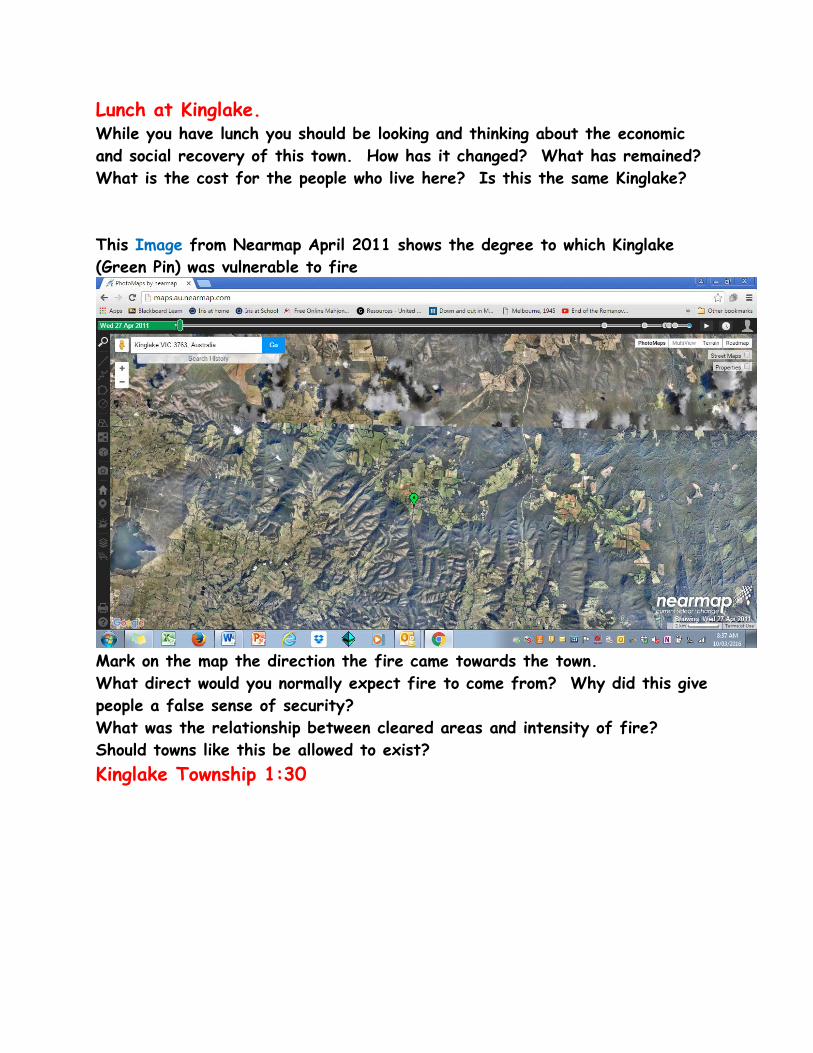
Lunch at Kinglake. While you have lunch you should be looking and thinking about the economic and social recovery of this town. How has it changed? What has remained? What is the cost for the people who live here? Is this the same Kinglake? This Image from Nearmap April 2011 shows the degree to which Kinglake (Green Pin) was vulnerable to fire
Mark on the map the direction the fire came towards the town. What direct would you normally expect fire to come from? Why did this give people a false sense of security? What was the relationship between cleared areas and intensity of fire? Should towns like this be allowed to exist? Kinglake Township 1:30

This image from Nearmap shows the town of Kinglake as it was in 2011.
As you walk around the town you should look for evidence of Economic and Community recovery Fill in the table below (remember some items may be both) Take photographs as you go but be discreet Economic Recovery Community Recovery
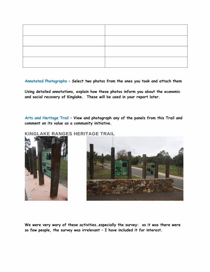
Annotated Photographs – Select two photos from the ones you took and attach them Using detailed annotations, explain how these photos inform you about the economic and social recovery of Kinglake. These will be used in your report later. Arts and Heritage Trail – View and photograph any of the panels from this Trail and comment on its value as a community initiative. KINGLAKE RANGES HERITAGE TRAIL
We were very wary of these activities…especially the survey: as it was there were so few people, the survey was irrelevant – I have included it for interest.

Survey questions
• Are you a resident of Kinglake? Yes / No
• If you are not a resident, do you live in the region? Where?
…………………………………………………………………………………………………………………………………………………
• If so how long have you lived here ……………………………………………………………….years
• Why did you choose to live here?
…………………………………………………………………………………………………………………………………………………
……………………………………………………………………………………………………………………………………………………
• What aspects living in Kinglake do you like?
……………………………………………………………………………………………………………………………………………………
……………………………………………………………………………………………………………………………………………………
……………………………………………………………………………………………………………………………………………………
• What aspects of Kinglake have not met your expectations?
……………………………………………………………………………………………………………………………………………………..
……………………………………………………………………………………………………………………………………………………..
• If you could make improvements to the current facilities and to the town, what would you
suggest or want to see done?
……………………………………………………………………………………………………………………………………………………
……………………………………………………………………………………………………………………………………………………
……………………………………………………………………………………………………………………………………………………
……………………………………………………………………………………………………………………………………………………
What do you love most about the area?
…………………………………………………………………………………………………………………………………………………
Is there anything else you would like to tell us about Kinglake?

The Research Element:
The focus of this was so huge that we had to make decisions about what we covered.
I chose to look at immediate, short term (defined as 5 years- which co-incided with the government definition) and long term.
For the short term we had the excellent discussion from Ann Maher, a volunteer from the community response organisation at Whittlesea and a local teacher from an affected school.
Her discussion covered both immediate and short term but she has now indicated that retelling the events has affected her recovery and will not speak publicly again. Several others approached were unwilling to talk during the summer, or were unavailable.
In the medium term we looked mainly at the Royal Commission into Black Saturday, at the court cases which were ongoing and at the revised Emergency Procedures and the revised Building Code. These were very big to deal with so I made selections and used executive summaries.
I decided to look at Strathewen as a case study of recovery. There are several excellent videos made of this small community and the responses to this. Their responses was to cling together very closely and this is now confirmed as the best method of recovery in a very recent University of Melbourne Study.
The references to much of this material are attached.
The long term recovery is largely environmental and social.
There has been an ‘outbreak” of delayed PTSD. Possibly the 10 year anniversary will put this to bed to some extent but some of those who rebuilt after the fires are now selling and moving and only 50% of the pre-fire population now lives in the area ( anecdotal from two residents in conversation). This appears to be a characteristic response and is echoed in the figures coming from Japan in the wake of the Tsunami.
Economically – most farming enterprises are up and running, but tourism is slow to recover. The reestablishment of walking trails has helped a great deal.
The Parks Victoria Staff also have much to offer in their discussion of the environmental recovery.

Structure of the report – please note – this largely echoes the Unit 3 structure….
1. Definition of topic – 200 words, 10 marks
Include: • A clear statement of the research question • An outline of the geographic context of the question
2. Sources of information -300 Words – 10marks Include: A clear statement of the methods you have used to gain your information The sources your have used to gain information Distinguish between Primary and Secondary Sources
3. Presentation of processed data and information – 10 marks
Include: • Appropriate maps, graphs and annotated photos, transects which are showing the meaning you want to communicate • Appropriate conventions on maps and graphs (e.g. BOLTSS) • Correct sourcing of the data and information
4. Analysis of processed data and information – 3 sections each about 500 words, 20 marks
• Identify the responses – environmental, sociological and economic • Describe how your processed data and information helps explain these responses • Draw relationships between key features and patterns in the processed data and information • Relate back to the research question and discuss whether or not the data and information has supported the hypothesis
5. Conclusion – 150-words, 10 marks

• Identify the extent to which the fieldwork helped you answer the research question Total marks: /70 Some References:
Kinglake and Lyre Birds
http://vnpa.org.au/page/nature-conservation/explore-our-parks/kinglake-national-park
https://www.youtube.com/watch?v=c7lTmIq4T7Q
https://www.facebook.com/ParksVictoria/photos/a.148227085237259.30269.121390137920954/892848614108432/?type=1&theater
Climate change and fires factsheet
http://www.climateinstitute.org.au/articles/publications/facts-and-myths-about-bushfires-and-climate-change.html?gclid=CjwKEAiAqJjDBRCG5KK6hq_juDwSJABRm03hj05qzPCe7BWnyF34JMeTtDBWLqsRn65t-n1Sk3PIkhoCgfDw_wcB
Recent Articles of Value that add to our understanding: http://www.abc.net.au/news/2016-11-29/black-saturday-bushfire-study-finds-mental-health-issues/8073514 http://www.news.com.au/technology/environment/researchers-devise-a-plan-that-could-have-helped-save-black-saturday-victims/news-story/7093b9442b44482e6bae57f434fb397d
http://www.weeklytimesnow.com.au/country-living/black-saturday-bushfires-trauma-of-a-black-day-lingers/news-story/238391e349591a7c42bfd64c6bbf78df https://theconversation.com/climate-councils-code-red-bushfire-warning-21257

https://theconversation.com/victorias-logged-landscapes-are-at-increased-risk-of-bushfire-30611
https://theconversation.com/au/topics/black-saturday-3290
http://www.abc.net.au/news/2016-03-17/victorian-helicopter-rescuer-awarded-for-black-saturday-bravery/7251042
http://www.abc.net.au/news/2016-11-29/black-saturday-bushfire-study-finds-mental-health-issues/8073514 (full report from University of Melbourne at this site)
https://australianrotaryhealth.org.au/the-impacts-of-the-black-saturday-bushfires/
http://www.dhs.vic.gov.au/__data/assets/pdf_file/0006/920346/Appendix-A-Vic-bushfire-appeal-fund-progress-report-Dec2014.pdf
Money allocated to specific recovery programs from the Bushfire Appeal Fund… gives a picture of the range of issues to be covered.
Resources – Video
https://www.youtube.com/watch?v=7klZ3_F6ekI
Channel 7 news – before the extent was understood
https://www.youtube.com/watch?v=QAp26V7bI_s
3 minutes – most powerful scenes
https://www.youtube.com/watch?v=tuYZRttpD9Y Inside the Firestorm
ABC Documentary – long, emotional, very powerful
https://www.youtube.com/watch?v=UMmGE5RNrR4 My Country – Australia Firestorm (Part 1)
BBC documentary in 4 parts - clear and less emotional – This is the one I have used
https://www.youtube.com/watch?v=VPyflU08hLg Part 2
https://www.youtube.com/watch?v=ZAighp8mWVQ Part 3
https://www.youtube.com/watch?v=CtwE-czjhEU Part 4

https://www.youtube.com/watch?v=F3dPlVvkIZ8
St Andrews – 4 minutes – watching the fires coming closer
https://www.youtube.com/watch?v=nXf-gBSAbXQ
Strathewen
https://www.youtube.com/watch?v=nXf-gBSAbXQ
Strathewen before, during, after 9 minutes – worth watching
https://www.youtube.com/watch?v=hu1QylTV7Ck
Strathewen environment recovery 5 min
https://www.youtube.com/watch?v=iLsNXXw4uvw
Strathewen recovery
https://www.youtube.com/watch?v=lb5Bbsq3kQ4
Strathewen Letterbox project
https://www.youtube.com/watch?v=8YxAUzRQgZo
Strathewen review of the recovery committee
https://www.youtube.com/watch?v=XbYI5dDlMeg When the Fires Come - about planning and preparation CFA sponsored video
https://www.youtube.com/watch?v=6_wJiHShUUs
Animal Welfare after the fires

Spatial Technologies requirement

The scale of the Kinglake fires superimposed on Melbourne Metropolitan Area

Reference Article 1 http://www.theage.com.au/victoria/bushfireproof-houses-burn-down-in-wye-river-and-separation-creek-as-experts-cast-serious-doubt-on-effectiveness-of-building-standards-20160225-gn3n9d.html Bushfire-proof houses burn down in Wye River and Separation Creek as experts cast serious doubt on effectiveness of building standards Date
February 25, 2016
Liam Mannix
The burnt out hills above Wye River. Photo: Jason South
Housing design standards implemented in the aftermath of Black Saturday are deeply flawed, experts say – with several bushfire-proofed homes already lost in bushfires this year.
In Christmas Day's Wye River and Separation Creek fire, at least five bushfire-rated homes were destroyed, Fairfax Media has learnt, despite local fire conditions not being nearly as intense as they were on Black Saturday in 2009.
That raises serious questions about Victoria's bushfire risk management policy, experts say.

Fire trucks snake along the Great Ocean Road near Wye River. Photo: Penny Stephens
Emergency Management Victoria, however, contests these claims and say the standards performed very well in an extremely intense fire.
Advertisement
A total of 116 houses were lost in the coastal hamlets of Wye River and Separation Creek after an out-of-control bushfire ripped through on Christmas Day. BAL, or "bushfire attack level", ratings were required for all new homes in fire-prone areas after a recommendation from the Bushfires Royal Commission in 2009. They prescribe a standard that new homes must be built to. The standard won't guarantee a building's survival, as fires are inherently unpredictable. But BAL40-rated homes, of the type built in Wye and Separation Creek, are designed for "increasing levels of ember attack and burning debris ... Together with increasing heat flux and and increased likelihood of exposure to flames". BAL40 is regarded as the general standard for homes facing significant fire threats.
The Bushfire Building Council of Australia, whose senior members include the former deputy chief officer of the CFA and a sitting member of the Australian Building Codes Board, says the standards are flawed.
"The type of fire and fire weather conditions [during the Christmas Day fire] were well within the design limitations of the building standards," Kate Cotter, the BBCA's chief executive, said.
Stephen Kip, a council member, fire safety engineer and board member of the Australian Building Codes Board, said: "There is half a dozen design flaws in them". The BBCA's critique of the standards includes
• No requirement to consider location of gas water heater • No requirements for gutter guards

• No ban on keeping a wood pile near the house • BAL-rated houses can be built right next to unrated houses • After the Wye River fires, new BAL-rated homes will be built right next to unrated
houses, which pose a serious fire risk. Getting BAL approval for a house is not cheap – in some cases, it can add as much as $50,000 to the cost of a build. For that sort of money, say experts, the fire defence should be more effective.
The CSIRO's lead bushfire infrastructure researcher wrote a report extensively critiquing the standards in 2009 and suggesting they were actually less effective than standards they replaced. Many of his recommendations remain unimplemented. Justin Leonard is the CSIRO researcher putting together the report on the Wye and Separation Creek fires.
His 2009 report to the Victorian Bushfires Royal Commission is extensively critical of the bushfire standards. Criticisms include:
• Combustible timbers are allowed to be used on doors and window-frames • No requirements verandas, decks or stairs be made from non-combustible material • No requirement to design for grassfires • No requirement to build sub-floor spaces that block the entrance of flammable material
like leaves. Mr Leonard says many of the flaws he identified have not been fixed.
"I cannot force the processes to adopt what the science says. At some point I have to decide to stick to what I do as an independent researcher."
Emergency Management Commissioner Craig Lapsley, who walked Wye River extensively after the blazes, believes fewer than 10 BAL-rated buildings burnt down and a number survived. He says the BAL standard no doubt served its purpose. "If anything, these buildings are stacking up to withstand the passage of fire.
"A fire in Wye River of that intensity or higher would have taken the whole town out. To lose 116 is a loss, but if they had of lost 334 houses that would have been a total loss. They lost a third of the building stock in the most difficult part of the town."
Peter Newland had a BAL-rated house in Wye River. It burnt to the ground – but he's not angry. Nothing could have survived the blaze, he says.
"The temperature of the fire near my house was hot enough to make glass melt into spiderweb filaments. To have temperatures that hot, nothing was going to survive."
For now, Wye River's community awaits the release of the CSIRO report.
The revelations came as the Inspector-General of Emergency Management reported that back-burning was an appropriate strategy to help fight and contain the Wye River.

IGEM Tony Pearce was charged with examining the Christmas Day fire.
Mr Pearce's report backed incident control view that the fire could not have been resourced more during the initial fire fight without an unacceptable escalation of risk.
"The back-burn strategy was successful in meeting its aim of reducing the fuel loads in the containment lines of the fire," the report said.
But Mr Pearce was critical of document and recording systems, saying that there were discrepancies between the incident control centre record of the number of firefighting resources being used and that of on scene logs.
"This situation has the potential to impact both firefighter safety and the effective utilisation of available resources."
The IGEM also found that the fire should have been escalated to a level 3 incident earlier, however he said the classification of the fire would not have changed the outcome.
Emergency Services Minister Jane Garrett said the government would accept all the recommendations as part of the continuous improvement of how agencies work together to respond to emergencies.
Reference Article 2 http://www.heraldsun.com.au/leader/north/wildlife-returning-to-kinglake-national-park-for-first-time-since-black-saturday/story-fnglenug-1226818644263
Wildlife returning to Kinglake National Park for
first time since Black Saturday
• MEGAN BAILEY DIAMOND VALLEY LEADER FEBRUARY 07, 2014 12:00AM
KOALAS, goannas and dunnarts have returned to Kinglake National Park for the first time since Black Saturday.
Parks Victoria ranger in charge Ion Maher said koalas had been seen near The Gums camping area and the Jehosaphat Gully picnic area.
>> INTERACTIVE: See how eight areas affected on Black Saturday have changed five years on

He said sightings of large goannas meant they probably survived the fires and were hiding in the park since.
"We haven't seen any (koalas) since the fires, but we have had reports of them over the past couple of weeks," he said.
"We have had reports of a one-metre long goanna in the last few weeks. At that size it would be more than five years old and a larger goanna would have survived the fires."
Mr Maher said rangers had placed tiles on the ground to serve as nesting areas for dunnarts and to monitor their numbers.
"We haven't seen much activity and it's been only recently that we have seen a lot of tiles that have had dunnarts under them," he said.
"We don't know if they are white-footed dunnarts or common ones; white-footed ones are rare.
"So if it is a white footed one, they are threatened and the common dunnarts are vulnerable, even though they are called common."
Mr Maher said lyrebird numbers were strong, but animals that were reliant on high tree canopies such as possums and pink and yellow robins still hadn't returned.
Reference Pages from Hazards and Disasters


![GEOGRAPHY - Fieldwork Enquiry: What might an exam ......State the title of your fieldwork enquiry in which human geography data were collected. [1 mark] Title of fieldwork enquiry:](https://static.fdocuments.net/doc/165x107/6020cc88ac72ad43286578c2/geography-fieldwork-enquiry-what-might-an-exam-state-the-title-of-your.jpg)