AGRICULTURAL SYSTEMS OF PAPUA NEW … Systems of Papua New Guinea ... Agricultural systems of Papua...
229
AUSTRALIAN AGENCY for INTERNATIONAL DEVELOPMENT AGRICULTURAL SYSTEMS OF PAPUA NEW GUINEA Working Paper No. 20 BOUGAINVILLE PROVINCE TEXT SUMMARIES, MAPS, CODE LISTS AND VILLAGE IDENTIFICATION RM. Bourke, M. Woruba, B.J. Allen, M. Allen, R. Grau and P. Hobsbawn REVISED and REPRINTED 2002 THE AUSTRALIAN NATIONAL UNIVERSITY PAPUA NEW GUINEA DEPARTMENT OF AGRICULTURE AND LIVESTOCK UNIVERSllY OF PAPUA NEW GUINEA
Transcript of AGRICULTURAL SYSTEMS OF PAPUA NEW … Systems of Papua New Guinea ... Agricultural systems of Papua...
AUSTRALIAN AGENCY for INTERNATIONAL DEVELOPMENT
AGRICULTURAL SYSTEMS OF PAPUA NEW GUINEA
Working Paper No. 20
BOUGAINVILLE PROVINCE
TEXT SUMMARIES, MAPS, CODE LISTS AND VILLAGE IDENTIFICATION
RM. Bourke, M. Woruba, B.J. Allen, M. Allen, R. Grau and P. Hobsbawn
REVISED and REPRINTED 2002
THE AUSTRALIAN NATIONAL UNIVERSITY
PAPUA NEW GUINEA DEPARTMENT OF AGRICULTURE AND LIVESTOCK
UNIVERSllY OF PAPUA NEW GUINEA

AGRICULTURAL SYSTEMS OF PAPUA NEW GUINEA
Working Paper No. 20
BOUGAINVILLE PROVINCE
TEXT SUMMARIES, MAPS, CODE LISTS AND VILLAGE IDENTIFICATION
R.M. Bourke, M. Woruba, B.J. Allen, M. Allen, R. Grau and P. Hobsbawn
Department of Human Geography, The Australian National University, ACT 0200, Australia
REVISED and REPRINTED 2002

ii
Correct Citation: Bourke, R.M., Woruba, M., Allen, B.J., Allen, M., Grau, R. and Hobsbawn, P. (2002). Bougainville Province: Text Summaries, Maps, Code Lists and Village Identification. Agricultural Systems of Papua New Guinea Working Paper No. 20. Land Management Group, Department of Human Geography, Research School of Pacific and Asian Studies, The Australian National University, Canberra. Revised edition. National Library of Australia Cataloguing-in-Publication Entry: Bougainville Province: text summaries, maps, code lists and village identification. Rev. ed. ISBN 0 9579381 1 X 1. Agricultural systems – Papua New Guinea – Bougainville Province. 2. Agricultural geography – Papua New Guinea – Bougainville Province. 3. Agricultural mapping – Papua New Guinea – Bougainville Province. I. Bourke, R.M. (Richard Michael). II. Australian National University. Land Management Group. (Series: Agricultural systems of Papua New Guinea working paper; no. 20). 630.99592 Cover Photograph: The late Gore Gabriel clearing undergrowth from a pandanus nut grove in the Sinasina area, Simbu Province (R.L. Hide).

iii
PREFACE Acknowledgements The following organisations have contributed financial support to this project: The Research School of Pacific and Asian Studies, The Australian National University; The Australian Agency for International Development; the Papua New Guinea-Australia Colloquium through the International Development Program of Australian Universities and Colleges and the Papua New Guinea National Research Institute; the Papua New Guinea Department of Agriculture and Livestock; the University of Papua New Guinea; and the National Geographic Society, Washington DC. Technical advice and encouragement have been provided throughout the project by John McAlpine, Gael Keig and Sue Cuddy, Australian Commonwealth Scientific and Industrial Research Organization. Support and advice have been received from Geoff Humphreys and Harold Brookfield of the Land Management Project, and Gerard Ward (formerly Director), Research School of Pacific and Asian Studies, The Australian National University. Brookfield's (1971) study of Melanesian agricultural systems has been particularly influential. The Papua New Guinea Agricultural Systems Project was developed from two previous studies. Michael Bourke began mapping Papua New Guinea agricultural systems in the 1970s while a Senior Horticulturalist with the PNG Department of Primary Industry (Bourke 1976). Robin Hide created an annotated bibliography of information on Papua New Guinea agricultural systems while working with the CSIRO PNGRIS group (Hide and Cuddy 1988). Participants The following persons participated in the production of this paper: Papua New Guinea Department of Agriculture and Livestock: Moses Woruba, Bill Humphrey (field mapping) Papua New Guinea National Research Institute: Tony Regan (information on Care Centres) North Solomons Province Administration: John Siau (formerly Provincial Secretary) Australian National University: Bryant Allen, Michael Bourke (conceptualisation, field mapping, data preparation, writing); Robin Grau (GIS management, ARC/INFO, map preparation); Matthew Allen, Patricia Hobsbawn (literature review); Janine Conway (research assistance). Field survey and interviews Only a small part of the information reported here was gathered during fieldwork. Because of the Bougainville crisis, it was not possible to conduct fieldwork in central and southern Bougainville and no fieldwork was done as part of the Mapping Agricultural Systems of Papua New Guinea project by the ANU team. Instead, 23 persons were interviewed. Some preliminary mapping was done briefly in the Kieta, Wakunai, Togarau and Panguna areas in December 1980. In September 1992, Moses Woruba and Bill Humphrey of LAES Keravat spent three days surveying agriculture on Nissan and Pinipel Islands. Moses Woruba briefly visited the
iv
Nuguria group of coral atolls at this time. He also conducted extensive interviews with islanders from all atoll groups when a group were at Keravat on a training course. Information for Buka and Bougainville came mainly from interviews conducted with 23 persons between June and December 1996. The persons interviewed described agriculture in their home areas or places where they had worked. Several people provided information on more than one location. The interviews were conducted in the Kokopo, East New Britain area (13); Keravat, East New Britain, area (5); Port Moresby (3) and Canberra (2). Thirteen men and ten women were interviewed. Their most recent visit ranged from eight years to three weeks prior to the interview. Sixteen of the interviewees had either resided or had had extended visits to the province in the early-mid 1990s (1992-1996). The other seven had been home for only short term visits or had not lived in the province since 1988. The occupations of the persons interviewed were agriculturalist (5), teacher (5), administration/clerical (4), villager (3), housewife (2), Aid Post Orderly (1), medical doctor (1), policeman (1) and post-graduate student (1). Each interview took one to three hours. All were conducted separately, except for two persons from Siwai who were interviewed together and the three informants from the Kanua area. Thus the information presented here comes from separate interviews of two to four persons for each agricultural system, except for the Kanua area where all three informants were together. The quality of the information obtained was remarkably good, although not as useful as fieldwork. Information was surprisingly consistent for each location. Several aspects of the database are likely to be less reliable than if fieldwork has been conducted. These are: 1. System boundaries. The system boundaries tend to coincide with cultural or administrative ones.
Fieldwork may have suggested different boundaries. For example, fieldwork may have indicated that locations on Bougainville above 300 m altitude should be classed as a single agricultural system with longer fallow periods, shorter cropping periods, taro an important crop and sweet potato not planted in mounds.
2. Fallow periods. These were determined from informants’ descriptions of fallow vegetation as well as the stated periods, as the latter are often underestimated in reality in Papua New Guinea.
3. Cropping periods. Information from informants was reasonably consistent, but not as accurate as would have been gained from numerous garden visits.
Nine agricultural systems have been identified for the province. Agriculture on Nissan and Pinipel Islands (System 2001), the smaller atolls (System 2002) and the small islands off the west coast of Buka Island (2004) is quite distinctive for each system. However, the systems for Buka Island (System 2003), the Tinputz-Wakunai area (System 2005), northwest Bougainville (System 2006) and southwest Bougainville (System 2008) are very similar. Only minor differences in sub-dominant staples, the number of plantings before fallow and cash cropping separate these four systems. Given the source of information, the differences may not be real (except for cash cropping where information appears reliable and consistent). The system in southeast Bougainville (System 2007) and south Bougainville (Buin area, System 2009) are similar to each other, but differ from the other four systems on Buka-Bougainville in that only one planting is made before land is fallowed in southeast and south Bougainville. The civil war (known as the Bougainville crisis in PNG) has caused considerable disruption to the villagers in parts of the province, especially in central, south and southwest Bougainville. In early 1997, PNG government sources indicate that some 45,000 people in Bougainville Province were

v
living in Care Centres. The largest concentration was in the Buin area where about 17,000 people were still in Care Centres. During the worst years of the crisis, in the early-mid 1990s, the PNG government was providing rice to many villagers in Care Centres throughout the province. The supply of rice was reported to be irregular and people still depended on food gardens to a greater or lesser degree. Most people who were still in Care Centres were growing most of their own food in their own gardens. However, some people were still mainly dependent on rice supplied by the government in early 1997. These people were located mainly in the Buin area (about 13,000 people) and in the Arawa area (about 4000 people). Much material relevant to agricultural development is summarised in the North Solomons Provincial Development Study, particularly Section A of Volume 2 (Economic Consultants 1982). While the information on cash supply is now dated, it still provides a useful overview for the province. Persons interviewed The following were interviewed at Kokopo, Keravat, Port Moresby and Canberra: Evelyn Boxall, Katherine Billy, Ben Hulo, Cyril Imako, Mary Jal, Lugakei Joe, Linda Kamang, Louise Kurika, Michael Lugabai, Eris Memora, Ambrose Mopei, Murray Nahiana, Rachael Rake, Sam Rangai, Salome Silovo, Jerry Sipana, Joyce Sipana, Ruth Spriggs, Samual Tapets, Heather Timate, Daniel Tokapip, Thomasina Umue and Moses Woruba. Their assistance is greatly appreciated. Revised and reprinted version The Mapping Agricultural Systems Project database was revised in late 1998 (see Introduction to Working Paper Number 1). This working paper was reprinted in 2002. Karen Lummis, Tess McCarthy, Natalie Stuckings, Laura Vallee, Amber Pares and Veerle Vlassak were responsible for the production of the revised paper.

vi

vii
CONTENTS
Preface iii
1. Introduction 1
2. Database Structure, Definitions and Codes 5
3. Agricultural Systems: Text Summaries 17
System 2001 19 System 2002 21 System 2003 25 System 2004 29 System 2005 31 System 2006 35 System 2007 39 System 2008 43 System 2009 49
4. Agricultural Systems: Maps 53
5. Agricultural Systems: Data Listing by Codes 73
6. Listings of Rural Villages (Census Units) Indexed to Agricultural Systems 85
6.1 Rural Villages with Agricultural System numbers in census order 87 6.2 Rural Villages with Agricultural System numbers in alphabetical order 93 6.3 Rural Villages listed by Agricultural System (with PNGRIS RMU numbers) 99
Appendix A.1 National Population Census Provincial Codes 105
Appendix A.2 National Population Census Codes for Districts and Census Divisions, Bougainville Province 106

viii
1
1. INTRODUCTION
The major purpose of the Papua New Guinea Agricultural Systems Project is to produce information
on small holder (subsistence) agriculture at provincial and national levels. Information is collected
by field observation, interviews with villagers and reference to published and unpublished
documents. The information is entered into a computer database (dBase IV), from where it is
transferred to a mapping program (ARC/INFO). Methods are described by Bourke et al. (1993).
This paper contains a written summary of the information on the Agricultural Systems in this
Province, maps of selected agricultural features, a complete listing of all information in the database
in coded form, and lists of villages with National Population Census codes, indexed by Agricultural
Systems. This information will eventually be available on disk as a map-linked database suitable
for use on a personal computer.
Identification of agricultural systems and subsystems
An Agricultural System is identified when a set of similar agricultural crops and practices occur
within a defined area. Six criteria are used to distinguish one system from another:
1. Fallow type (the vegetation which is cleared from a garden site before cultivation).
2. Fallow period (the length of time a garden site is left unused between cultivations).
3. Cultivation intensity (the number of consecutive crops planted before fallow).
4. The staple, or most important, crops.
5. Garden and crop segregation (the extent to which crops are planted in separate gardens; in
separate areas within a garden; or are planted sequentially).
6. Soil fertility maintenance techniques (other than natural regrowth fallows).
Where one or more of these factors differs significantly and the differences can be mapped, then a
separate system is distinguished.
Where variation occurs, but is not able to be mapped at 1:500 000 scale because the areas in which
the variation occurs are too small or are widely dispersed within the larger system, a subsystem is
identified. Subsystems within an Agricultural System are allocated a separate record in the
database, identified by the Agricultural System number and a subsystem number.
Sago is a widespread staple food in lowland Papua New Guinea. Sago is produced from palms
which are not grown in gardens. Most of the criteria above cannot be applied. In this case, systems
are differentiated on the basis of the staple crops only.

2
Relationship to PNGRIS
The Papua New Guinea Resource Information System (PNGRIS) contains information on the
natural resources of PNG (Bellamy 1986). However PNGRIS contains no information on
agricultural practices, other than an assessment of land use intensity based on air photograph
interpretation by Saunders (1993), and ECOPHYS which is concerned with predicted crop
performance in a specific environment (Hackett 1988). The Agricultural Systems Project is
designed to provide detailed information on agricultural practices and cropping patterns as part of an
upgraded PNGRIS geographical information system. For this reason the Agricultural Systems
database contains almost no information on the environmental settings of the systems, except for
altitude and slope. The layout of the text descriptions, the database code files and the village lists
are modelled on PNGRIS formats (Cuddy 1987).
The mapping of Agricultural Systems has been carried out on the same map base and scale as
PNGRIS (Tactical Pilotage Charts, 1:500 000). It is also done within the areas of agricultural land
use established by Saunders (1993) from aerial photography. Except where specifically noted,
Agricultural Systems boundaries have been mapped without reference to PNGRIS Resource
Mapping Unit (RMU) boundaries. Agricultural Systems are defined at the level of the Province
(following PNGRIS) but their wider distribution is recognised in the database by cross-referencing
systems which cross provincial borders.
A preliminary view of the relationships between RMUs and the Agricultural Systems in this
Province can be obtained from the listing of villages by Agricultural System, where RMU numbers
are appended (Section 6.3).
Note for reprinted edition
Most of the fieldwork for this project was conducted over a six year period (late 1990 to late 1996).
Over this period, a number of minor inconsistencies arose in data classification and presentation.
As well, some changes occurred in conventions for the text fields and in the definitions of data
fields, for example, for seasonality, fencing and burning. These changes were noted in the Preface
of the Provincial Working Papers (first editions) as they occurred. One of the more important
changes was that the cutoff points for the classification of cash earning activities were applied more
consistently. Because of these inconsistencies and changes in definitions, it was necessary to revise
the database so that it was consistent for all 19 provinces and to incorporate changes in agriculture
systems since the original papers were produced.
Most changes, as distinct from definitional changes, relate to cash income. The revisions were done
in late 1998. The largest number of changes occurred in the first four provincial working papers:
East Sepik, West Sepik, Western and Gulf Provinces. Papers for the five Island Region provinces
required the least number of changes. Agricultural systems that cross provincial boundaries have
been adjusted so that the information is identical on both sides of the boundary, apart from some
minor differences in some of the text fields. However the notes have not been updated to
incorporate new publications since the Working Papers were completed.
3
References Bellamy, J. (ed) 1986 Papua New Guinea Inventory of Natural Resources, Population Distribution and Land Use Handbook. CSIRO Division of Water and Land Resources, Natural Resources Series No. 6, Canberra. Bourke, R.M. 1976 Food crop farming systems used on the Gazelle Peninsula of New Britain. In K. Willson and R.M. Bourke (eds) Proceedings of the 1975 Papua New Guinea Food Crops Conference, Department of Primary Industry, Port Moresby, 81-100. Bourke, R.M., R.L. Hide, B.J. Allen, R. Grau, G.S. Humphreys and H.C. Brookfield 1993 Mapping agricultural systems in Papua New Guinea. In T. Taufa and C. Bass (eds) Population, Family Health and Development. Volume 1 of Papers from the 19th Waigani Seminar, Port Moresby, 16-22 June 1991. University of Papua New Guinea Press, Port Moresby, 205-224. Brookfield, H.C. with D. Hart 1971 Melanesia: a Geographical Interpretation of an Island World. Methuen, London. Cuddy, S.M. 1987 Papua New Guinea Inventory of Natural Resources, Population Distribution and Land Use: Code Files Parts I-VII. CSIRO Division of Water and Land Resources, Canberra. Economic Consultants 1982 North Solomons Provincial Development Study. Final Report. Economic Consultants Limited in assocation with Shankland Cox Partnership, Booker Agriculture International Limited and Sea Fish Industry Authority. Hackett, C. 1988 Matching Plants and Land: Development of a General Broadscale System from a Crop Project for Papua New Guinea. CSIRO Division of Water and Land Resources, Natural Resources Series No. 11, Canberra. Hide, R.L. and S.M. Cuddy 1988 Papua New Guinea Inventory of Natural Resources, Population Distribution and Land Use: Annotated and Selected Bibliography of Smallholder Farming Systems in PNG: Part I New Guinea Mainland, New Guinea Islands. CSIRO Division of Water and Land Resources, Canberra. National Nutrition Survey 1982/3. Provincial Tabulations. Papua New Guinea Institution of Medical Research and Nutrition Section, National Department of Health, Goroka. Ruthenberg, H. 1980 Farming Systems in the Tropics. Oxford University Press, London. Saunders, J.C. 1993 Agricultural Land Use of Papua New Guinea [map with explanatory notes]. Scale 1:1 000 000. PNGRIS Publication No. 1. CSIRO, Brisbane.
Smith, T., G. Keig, J. Marks and R. Grau 1992 Summary Results by Environmental Zone from the
1982-3 National Nutrition Survey of Papua New Guinea: Implications for Future Survey Design.
Papua New Guinea Institute of Medical Research, Goroka.

4

5
2. DATABASE STRUCTURE, DEFINITIONS AND CODES
Information on agricultural systems is stored in a database, one record per agricultural system (or
subsystem where identified) and 108 fields per record. This section lists the field names and their
database abbreviations [NAMES]. Summary descriptions, explanatory notes and variable codes are
given for each field.
LOCATION AND IDENTIFICATION
1. Provincial Identification [PROVINCE]: A two digit National Population Census code. Eg. code
14 = East Sepik Province. Provincial codes are listed in Appendix A.1.
2. System Identification [SYSTIDNO]: A two digit number identifying the agricultural system within
this province. Eg. code 01 = System 01. Numbers are not assigned to systems within a province in
any particular order.
3. Agricultural System [AGSYST]: Systems are also identified by a unique Papua New Guinea-wide
four digit number. The first two digits are the National Population Census provincial code and the
second two digits are the system identification number. Eg. 1401 = System 01 in the East Sepik
Province.
4. Agricultural Subsystem [SUSBSYSIDNO]: Subsystems are identified by a single digit. When
referred to in the text they are preceded by the agricultural system number and a hyphen. Eg. 1418-1
is Subsystem 1 of System 1418.
5. Number of Subsystems [NUMSUBSYS]: A single digit specifying the number of subsystems that
occur within this System.
6. District [DISTRICT]: The 1990 National Population Census code for the District within which the
System is located. More than one District may be listed. District codes are listed in Appendix A.2.
7. Census Divisions [CENSUSDIV]: The 1980 National Population Census code for the Census
Divisions that occur within the System. Census Division codes for this Province are listed in
Appendix A.2.
ENVIRONMENTAL
8. Lowest Altitude [ALTLOW]: The lowest altitude, in metres (rounded), to which the System
extends.
9. Highest Altitude [ALTHIGH]: The highest altitude, in metres (rounded), to which the System
extends.
10. Garden Slope [SLOPE]: The average slope of gardens in the System.
1 Flat (<2o)
2 Gentle (2-10o)
3 Steep (10-25o)
4 Very steep (>25o)
5 Multiple classes
6
11. Survey Description [SURVDESC]: A text description of the areas visited or not visited within the
system, the length of time spent in different areas, traverses undertaken, the mode of transport used,
the month and year of the survey, and the sources of any documentary information used.
12. Summary Description [SYSSUMM]: A concise text description of the agricultural system, and
subsystems (if any), focussed on the occurrence of the major distinguishing criteria.
13. System Boundary Definitions [BOUNDDEF]: A brief description of how the boundaries between
systems were identified and mapped. The boundaries between agricultural and non-agricultural land
use were taken from Saunders (1993).
14. Systems Crossing Provincial Borders [OTHPROV]: A logical field (yes/no) which indicates
whether the System crosses a provincial border.
15. Same System in Adjacent Province [PROVSYS]: A listing of AGSYST numbers (see Field 3
above) of up to two systems in adjacent provinces which are identical to this system, for systems
which cross provincial borders.
16. Subsystem Extent [SUBSYSEXT]: An estimate of the proportion of the area of the total system
occupied by a subsystem. In the case of there being no subsystems this field is listed as 100 per
cent.
1 25 per cent
2 50 per cent
3 75 per cent
4 100 per cent
17. Type of Fallow Vegetation Cleared [FALLTYPE]: The predominant type of vegetation cleared
from garden sites at the beginning of a new period of cultivation. Where short fallows are used (see
Field 18 below), fallow type refers to the vegetation cleared after a long fallow.
1 Short grass (eg. kunai < 1.5 m tall)
2 Tall grass (eg. Miscanthus or Saccharum > 1.5 m tall)
3 Grass and woody regrowth (dense short or tall grass and short woody
regrowth)
4 Short woody regrowth (shrubs/trees < 10 m tall)
5 Tall woody regrowth (trees > 10 m tall)
6 Forest (no indication of previous use)
7 No long fallow
8 Savanna (Scattered woody growth with grass ground cover)
18. Use of Short Fallows [SHORTFALL]: A presence and significance measure which indicates
whether short fallows are used. Short fallows are brief periods of less than 12 months between
plantings during which land is left fallow.
19. The Long Fallow Period [FALLPER]: An estimate of the length of time (greater than 12 months)
land is left to revert to regrowth, before it is cultivated again. Class 0 refers to situations where very
long cropping intervals (40 plantings or more) make long fallows not significant.
0 Not significant
1 1 to 4 years
2 5 to 15 years
3 Greater than 15 years
7
20. Cropping Intensity [CROPINT]: The number of times staple crops are planted in the main
gardens before those gardens are returned to a long fallow. Short fallows of less than 12 months (see
Field 18 above) are excluded for this purpose: they may occur between plantings without affecting
the classification. The class 'More than 40 plantings', refers to situations where land has been
planted continuously without a long fallow since the Pacific War (1942-45) or longer. In such cases
Field 19, Long Fallow Period, is classed as 'Long fallow period not significant'.
1 1 planting only
2 2 plantings
3 3 to 5 plantings
4 6 to 14 plantings
5 15 to 40 plantings
6 More than 40 plantings
CROP COMPONENTS
21. The Dominant Staple Crops [DOMSTAP]: The most important staple food crops grown in the
subsystem. A major staple is defined as a crop estimated to cover more than one-third of staple
garden area, and therefore no more than 3 dominant staples may be identified for a system. An
important exception occurs when sago is the staple. Sago is extracted from palms which are not
cultivated in gardens. In the text accounts (System Summaries and Notes), dominant staples are
described as the 'most important crops'.
22. The Subdominant Staple Crops [SUBSTAP]: Staple food crops of lesser importance grown in the
subsystem. A subdominant staple is defined as a crop estimated to cover more than 10 per cent of a
staple garden area; up to six crops may be listed. An important exception occurs when sago is the
staple. Sago is extracted from palms which are not cultivated in gardens. In the text accounts
(System Summaries and Notes), subdominant staples are described as 'important crops'.
23. All Staple Crops [ALLSTAP]: A list of up to 10 staple crops including crops classed as dominant
and subdominant, as well as other staple crops which occur commonly. In the text accounts (System
Summaries and Notes), staple crops which are classified as neither dominant nor subdominant are
described as 'other crops'.
01 Mixed staple (no dominant staple: a mix of some or all of: banana, taro, sweet potato
Chinese taro, yam, cassava and corn)
02 Banana (Musa cvs) 13 Taro (Colocasia esculenta)
03 Breadfruit (Artocarpus altilis) 14 Yam (Dioscorea alata)
04 Cassava (Manihot esculenta) 15 Yam (Dioscorea esculenta)
05 Chinese taro (Xanthosoma sagittifolium) 16 Yam (Dioscorea pentaphylla)
06 Coconut (Cocos nucifera) 17 Other
07 Corn (Zea mays) 18 Queensland arrowroot (Canna
08 Potato (Solanum tuberosum) edulis)
09 Sago (Metroxylon sagu) 19 Taro (Amorphophallus)
10 Swamp taro (Cyrtosperma (Amorphophallus paeoniifolius)
chamissonis) 20 Yam (Dioscorea bulbifera)
11 Sweet potato (Ipomoea batatas) 21 Yam (Dioscorea nummularia)
12 Taro (Alocasia macrorrhiza)

8
24. Other Vegetable Crops [VEG]: A list of up to 10 important vegetable crops:
01 Aibika (Abelmoschus manihot) 22 Rungia (Rungia klossii)
02 Amaranthus (Amaranthus spp.) 23 Tulip (Gnetum gnemon)
03 Bean, common (Phaseolus vulgaris) 24 Valangur (Polyscias spp.)
04 Bean, lablab (Lablab purpureus) 25 Balbal (Erythrina variegata)
05 Bean, winged (Psophocarpus 26 Bamboo shoots
tetragonolobus) 27 Bean, snake (Vigna unguiculata)
06 Cabbage (Brassica oleracea 28 Spring onion (Allium cepa var. cepa)
var. capitata) 29 Sweet potato leaves (Ipomoea batatas)
07 Chinese cabbage (Brassica chinensis) 30 Taro leaves (Colocasia esculenta)
08 Choko tips (Sechium edule) 31 Watercress (Nasturtium officinale)
09 Corn (Zea mays) 32 Other
10 Cucumber (Cucumis sativus) 33 Bean, lima (Phaseolus lunatus)
11 Ferns 34 Bottle gourd (Lagenaria siceraria)
12 Ginger (Zingiber officinale) 35 Dicliptera (Dicliptera papuana)
13 Highland pitpit (Setaria palmifolia) 36 Kalava (Ormocarpum orientale)
14 Kangkong (Ipomoea aquatica) 37 Karakap (Solanum nodiflorum)
15 Kumu musong (Ficus copiosa) 38 Basil (Ocimum basilicum)
16 Lowland pitpit (Saccharum edule) 39 Bean leaves (Phaseolus spp.)
17 Nasturtium (Nasturtium spp.) 40 Cassava leaves (Manihot esculenta)
18 Oenanthe (Oenanthe javanica) 41 Chilli leaves (Capsicum frutescens)
19 Peanuts (Arachis hypogaea) 42 Eggplant (Solanum melongena)
20 Pumpkin fruit (Cucurbita moschata) 43 Pigeon pea (Cajanus cajan)
21 Pumpkin tips (Cucurbita moschata) 44 Tomato (Lycopersicon esculentum)
25. Fruit Crops [FRUIT]: A list of up to 8 important fruits grown:
01 Avocado (Persea americana) 21 Granadilla (Passiflora
02 Banana (Musa cvs) quadrangularis)
03 Bukabuk (Burckella obovata) 22 Grapefruit (Citrus paradisi)
04 Coastal pandanus (Pandanus tectorius) 23 Guava (Psidium guajava)
05 Malay apple (Syzygium malaccense) 24 Lemon (Citrus limon)
06 Mandarin (Citrus reticulata) 25 Lime (Citrus aurantifolia)
07 Mango (Mangifera indica) 26 Parartocarpus (Parartocarpus
08 Marita pandanus (Pandanus conoideus) venenosa)
09 Orange (Citrus sinensis) 27 Pomelo (Citrus maxima)
10 Passionfruit, banana (Passiflora 28 Pouteria (Pouteria maclayana)
mollissima) 29 Raspberry (Rubus spp.)
11 Passionfruit, other (Passiflora spp.) 30 Soursop (Annona muricata)
12 Pawpaw (Carica papaya) 31 Tree tomato (Cyphomandra betacea)
13 Pineapple (Ananas comosus) 32 Watery rose apple (Syzygium
14 Rambutan (Nephelium lappaceum) aqueum)
15 Sugar (Saccharum officinarum) 33 Governor's plum (Flacourtia
16 Ton (Pometia pinnata) indica)
17 Watermelon (Citrullus lanatus) 34 Lovi-lovi (Flacourtia inermis)
18 Other 35 Mon (Dracontomelon dao)
19 Custard apple (Annona squamosa) 36 Rukam (Flacourtia rukam)
20 Golden apple (Spondias cytherea) 37 Ficus (Ficus spp.)

9
26. Nut Crops [NUT]: A list of up to 5 important nuts grown or collected:
01 Breadfruit (Artocarpus altilis) 09 Karuka, wild (Pandanus brosimos)
02 Candle nut (Aleurites moluccana) 10 Okari (T. kaernbachii/ T. impediens)
03 Castanopsis (Castanopsis 11 Sis (Pangium edule)
acuminatissima) 12 Pao (Barringtonia spp.)
04 Coconut (Cocos nucifera) 13 Tulip (Gnetum gnemon)
05 Finschia (Finschia chloroxantha) 14 Other
06 Galip (Canarium indicum) 15 Polynesian chestnut (Inocarpus
07 Java almond (Terminalia catappa) fagifer)
08 Karuka, planted (Pandanus 16 Cycad (Cycas spp.)
julianettii) 17 Entada (Entada scandens)
18 Dausia (Terminalia megalocarpa)
27. Narcotic Crops [NARC]: A list of up to 5 important narcotics grown:
1 Betel nut, highland (Areca macrocalyx)
2 Betel nut, lowland (Areca catechu)
3 Betel pepper, highland (Piper gibbilimbum)
4 Betel pepper, lowland (Piper betle)
5 Tobacco (Nicotiana tabacum)
6 Kava (Piper methysticum)
FORMS OF GARDEN AND CROP SEGREGATION
28. Garden Segregation [GARDSEG]: A presence and significance measure of whether individual
staple food crops are planted in different gardens. A garden is a contiguous area of land planted
with crops under the management of a social unit such as a family or a household. If some gardens
are sited in different vegetation zones, and have different fallow periods, cultivation periods or other
agronomic characteristics, then they are assigned to a separate subsystem.
All presence and significance measures are coded as follows:
0 None
1 Minor or insignificant
2 Significant
3 Very significant
29. Crop Segregation [CROPSEG]: A presence and significance measure of whether individual
staple food crops are planted separately in different parts of the same garden.
30. Crop Sequences [CROPSEQU]: A presence and significance measure of whether the harvesting
of one crop species is usually followed by the planting of another, eg. yams followed by sweet
potato, or sweet potato followed by peanuts followed by sweet potato (see also Field 33 below).
31. Mixed Vegetable Gardens [MIXGARD]: A presence and significance measure of whether mixed
gardens are used. A mixed garden is typically a garden which is subsidiary to that containing the
main staple(s). It is planted with a wide range of either subdominant staples and/or other vegetables.
It may or may not be distinguished from the main garden types by different fallow and agronomic
techniques.
32. Household Gardens [HOUSGARD]: A presence and significance measure of whether house
gardens are used. A house garden is typically a garden that is small relative to the main gardens, is
located near houses, and which contains a variety of crops. Also known as door yard or kitchen
gardens.

10
SOIL FERTILITY MAINTENANCE TECHNIQUES
33. Legume Rotation [LEGUMROT]: A presence and significance measure of whether a leguminous
crop (eg. peanuts or winged bean) is grown between plantings of main food crops.
34. Planted Tree Fallow [TREEFALL]: A presence and significance measure of whether tree species
(eg. Casuarina oligodon or Parasponia spp.) are planted into gardens or fallows for the stated
purpose of improving soil quality during subsequent cultivations. This measure excludes the
practice of planting fruit tree species into gardens and fallows, but does not exclude the planted trees
being used for timber or firewood.
35. The Use of Compost [COMPOST]: A presence and significance measure of whether organic
matter is placed beneath the surface of the soil.
36. The Use of Animal Manure [MANURE]: A presence and significance measure of whether
animal manure is placed on or in the soil. The measure does not include the deposition of manure by
the animals themselves, eg. pigs tethered in gardens.
37. The Use of Island Beds: [ISLBED]: A presence and significance measure of whether island beds
are used. Island beds are beds of soil on which crops are planted and which are raised above the
level of a surrounding area of standing or slowly moving water.
38. The Contribution of Silt from Flooding [SILT]: A presence and significance measure of
whether silt from floods is deposited either regularly or sporadically on the soil surface in gardens.
It is assumed the flooding is of natural causes, but the measure does not exclude deliberate
manipulation of stream channels in order to enhance the delivery of silt or for the partial control of
flood waters.
39. The Use of Inorganic Fertiliser [FERT]: A presence and significance measure of whether
inorganic fertiliser is applied to gardens. This measure excludes the use of inorganic fertiliser on
cash crops, such as coffee or vegetables.
OTHER AGRICULTURAL PRACTICES
40. The Placing of Pigs in Gardens [PIGSIN]: A presence and significance measure of whether pigs
are placed in gardens between plantings. Pigs may be placed in gardens between plantings for a
number of stated reasons, eg. to eat earthworms, to eat unharvested crops, or to till the soil. This
measure excludes the deliberate breaking of fences to allow pigs to forage after the cropping phase.
41. Burning [BURN]: A presence and significance measure of whether fallow vegetation cleared and
cut in a new garden site is burnt before the planting of the staple crops. The measure includes the
burning of material which has been heaped. Significance takes into account the frequency of burning
relative to the cropping intensity. So, for example, if the majority of the fallow material cleared from
the site is burnt at the initial clearing of a garden, and only one or two plantings are made before
fallowing, burning is Very Significant. If the same thing occurs at clearing, but a large number of
plantings are made before the next long fallow, with little or no burning between plantings, burning
is Minor.
11
42. Soil Tillage [TILL]: A presence and significance measure of whether soil in the staple food
gardens is tilled before planting. Tillage includes the breaking up, or turning over, of the whole or
the major part of the soil on the garden surface. The measure includes tillage in either the first
planting and/or subsequent plantings. The formation of soil mounds and beds (see Fields 53-58
below) involves working the soil into a tilth, but in order to distinguish clearly between these
processes, mounds and beds are not automatically classified as soil tillage.
43. The Use of Deep Holing [HOLE]: A presence and significance measure of whether deep holing
is used. Deep holing is sometimes used in yam cultivation in order to influence the dimensions and
shape of the tubers. Deep (> 50 cm) holes are dug, the soil is broken into a fine tilth and the hole re-
filled before planting. The use of this technique is usually restricted to the cultivation of Dioscorea
alata.
44. Cutting Fallow Vegetation Onto the Crops [FALLCUT]: A presence and significance measure of
whether crops are planted beneath standing fallow vegetation, and the vegetation is later cut down
onto the growing crops.
45. The Use of Fences [FENCE]: A presence and significance measure of whether gardens are
fenced. Fences are linear barriers made of wood, bamboo, cane grass or stones, and may incorporate
a ditch or a bank. The measure excludes low ridges which form between fields when stones are
thrown to the perimeter during cultivation. In the assessment of the significance of fences, the
occurrence of fences around every individual garden is given greater significance than one fence
around a large number of gardens.
46. The Use of Irrigation [IRRIG]: A presence and significance measure of whether water is applied
to crops by the use of channels or aqueducts.
47. The Use of Mulch [MULCH]: A presence and significance measure of whether a mulch is used
to cultivate the staple crops. A mulch is organic material which is applied to the soil surface. If the
material is placed beneath the soil surface it is defined as a compost (see Field 35 above).
48. The Seasonality of Main Crops [SEASMAJ]: A presence and significance measure of whether
the dominant staples (most important food crops) and the subdominant staples (important food
crops) are planted at about the same time each year.
49. The Seasonality of Other Crops [SEASMIN]: A presence and significance measure of whether
other staple crops and vegetable crops are planted at about the same time each year.
50. The Use of Drains [DRAIN]: A presence and significance measure of whether ditches are used in
and around gardens to remove surface water or to lower the groundwater table.
51. The Use of Soil Retention Barriers [SOILRET]: A presence and significance measure of whether
structures (pegged logs, fences or hurdles, stone walls) are constructed along the contour or below
individual plants, in order to prevent or reduce the down slope movement of soil.
52. The Use of Staking [STAKE]: A presence and significance measure of whether crops are trained
or tied up stakes, trellises or standing dead trees to lift them off the soil surface. The practice is
usually applied to yams (Dioscorea spp.), beans, sugarcane, and sometimes gourds, cucumber and
choko.

12
MOUNDING TECHNIQUES
In many parts of Papua New Guinea the soil is formed into circular mounds of varying dimensions
and crops are planted on them. Mounding should not be confused with composting (see Field 35
above). Mounds may or may not contain compost and composting may take place in the absence of
mounds. Mounds are usually re-formed at each new planting. Mound formation usually involves
extensive soil disturbance. The effect can be similar to complete soil tillage (see Field 42 above).
The following fields contain presence and significance measures of whether mounds of the specified
dimensions are used in the system.
53. Very Small Mounds [VSMMOUND]: Mounds up to 10 cm high.
54. Small Mounds [SMMOUND]: Mounds 10 to 40 cm high.
55. Medium Sized Mounds [MOUND]: Mounds 40-70 cm high and between 1 m and 2.5 m in
diameter.
56. Large Mounds [LRGEMOUND]: Mounds > 70 cm high and > 2.5 m in diameter.
GARDEN BED TECHNIQUES
In some locations the soil is also raised into beds and crops planted on them. Bed formation usually
involves extensive soil disturbance. The effect can be similar to complete soil tillage (see Field 42
above). Two shapes of beds are distinguishable:
57. Square Beds [BEDSQ]: Square beds are constructed by digging shallow ditches typically 2 to 4
metres apart on a grid layout, and throwing the soil removed onto the surface to form a bed. The
outcome is a characteristic chequerboard or gridiron pattern in gardens.
58. Long Beds [BEDLONG]: Long beds are constructed by digging shallow ditches down slope
typically 2 to 4 metres apart and over 10 metres in length, and throwing the soil removed to the
centre to form a bed.
59. Mechanical Soil Tillage [MECHAN]: The use of tractors or hand-held cultivators in the
preparation of a garden site for food crops. The measure includes the use of machinery in the
cultivation of crops for sale.
CASH EARNING ACTIVITIES
A presence and significance measure of the importance of the following common rural cash income
sources. The list includes sources related to agricultural or land based production from the farmers'
own resources.
60. Animal Products [ANSKIN]: The sale of animal skins, furs and bird plumes, but not fresh meat.
61. Betel Nut [BETEL]: The sale of betel nuts (Areca catechu or A. macrocalyx) and associated
items like pepper and lime.
62. Cardamom [CARDAM]: The sale of cardamom (Elettaria cardamomum).
63. Cattle [CATTLE]: The sale of cattle as live beasts or as fresh meat.

13
64. Chillies [CHILLIE]: The sale of dried chillies (Capsicum frutescens).
65. Cocoa [COCOA]: The sale of cocoa (Theobroma cacao) beans.
66. Copra [CNUT]: The sale of copra and nuts from coconut palms (Cocos nucifera).
67. Arabica Coffee [COFFARAB]: The sale of Arabica coffee (Coffea arabica).
68. Robusta Coffee [COFFROB]: The sale of Robusta coffee (Coffea canephora).
69. Crocodile Products [CROC]: The sale of freshwater and saltwater crocodile (Crocodylus spp.)
skins or meat, from managed and wild animals.
70. Firewood [FIREWOOD]: The sale of firewood.
71. Fish [FISH]: The sale of fresh or smoked freshwater or saltwater fish, shellfish or crustacea.
72. Fresh Food: [FOOD]: The sale of fresh vegetables, fruits, nuts and fresh or smoked meat from
domesticated or wild animals.
73. Oil Palm [OILPALM]: The sale of palm oil fruit (Elaeis guineensis).
74. Potato [POTATO]: The sale of Irish potatoes (Solanum tuberosum).
75. Pyrethrum [PYRETH]: The sale of dried pyrethrum flowers (Chrysanthemum cinerariaefolium).
76. Rice [RICE]: The sale of rice (Oryza sativa).
77. Rubber [RUBB]: The sale of latex from rubber trees (Hevea brasiliensis).
78. Sheep and Wool [SHEEP]: The sale of sheep as live animals, or meat and the sale of wool.
79. Tea [TEA]: The sale of unprocessed tea (Camellia sinensis).
80. Tobacco [TOBACCO]: The sale of the dried tobacco leaf (Nicotiana tabacum).
81-82. Other [OTHER1] [OTHER2]: Other unlisted sources of cash include the sale of copal gum
(Agathis sp.), massoi bark (Massoia aromatica), tigasso oil (Campnosperma sp.), salt extracted
from plants or natural springs and deposits, mineral oil, bêche-de-mer, insects and butterflies, live
birds, marsupials, pigs and horses, house building materials including thatching and sheets of woven
cane, canoe hulls, clothing, weapons, string bags, carvings and artefacts. This category excludes
other sources of cash income such as wages and salaries, logging or mining royalties, gold mining,
banditry, gambling and remittances. These are mentioned in Notes (Field 83) if they are important.
83. Further Notes [NOTES]: Additional notes on particularly outstanding features of the system and
further information drawn from published and unpublished documents.

14
SURVEY DETAILS
Fields 84-101 contain details of dates when observations were made of the system for the purposes
of this project and the names of the persons who made the observations. Up to three survey visits
can be accommodated. The field names are:
Month of a short visit [SVDATMON]: Eg. 01 = January.
Year of a short visit [SVDATYR]: Eg. 1992.
Period of a longer term study [SVPERYRA]: Eg. 1971-72.
Person making the visit [SURVNAME]: Initials of person(s). Full names are given in a Key on the
relevant page in Section 5.
The type of survey [SURVTYPE]
1 Very brief visit to one place (less than an hour), or interviews
2 Short visit to a few places ( less than 1 day)
3 Visits to several places (1 to 3 days)
4 Multiple visits to many places (4 to 15 days)
5 Multiple visits to many locations over several years ( more than 15 days)
102. Information From the National Nutrition Survey 1982-83 [NNS]: The National Nutrition
Survey 1982/83, selected families in villages across most of the country from a sampling frame
based on environments drawn from PNGRIS classifications. Amongst other questions, people were
asked what foods they had eaten during the previous day (NNS 1982/3). For systems in which more
than 10 families were interviewed, responses for particular foods are presented as percentages of the
total number of families interviewed. Results are presented only for staple foods, fresh fish and
purchased rice. The entry includes the number of families and number of villages surveyed, and the
month and year of survey.
This information is more than 10 years old and is independent of the information collected by the
Agricultural Systems Project. It should be used carefully (Smith et al. 1992). In some Systems the
sample size is small and villages sampled may be restricted to one part of the System. It is possible
that Chinese taro (Xanthosoma sagittifolium) has been included in the general term 'taro', increasing
the importance of taro (Colocasia esculenta) and decreasing the importance of Chinese taro. Where
diets change seasonally, the results may also be unrepresentative.
103. Main References [REF]: References to published and unpublished documents that contain
substantial information on agriculture in the System.
104. Other References [REF2]: References to published and unpublished documents that contain
additional information directly relevant to the Agricultural System.
105. The Area of the System [AREA]: The area, in square kilometres, occupied by the System. The
figure is calculated by the mapping program ARC/INFO.
106. Total Resident Population 1980 [TOTPOP]: The total population resident within the area
covered by the System at the time of the 1980 National Population Census. The 1990 National
Population Census figures are not used because of questions over their reliability, but the 1990
National Population Census maps are used to locate most Census Units.
15
107. The Number of People Living Outside the System [ABSPOPPER]: An estimate of the
proportion of the population absent from villages in the system in 1978-79, expressed as a
percentage of the total population. The figure is the difference between the 'total' population and the
'resident' population listed in the 1978-79 Provincial Data System (PDS) Rural Community Register
for the Province. The 'total' population is the total number of persons listed in the Village Book and
the 'resident' population the number living in the village, or who have been absent for less than 6
months at the time of the census. In some cases 'total' and 'resident' populations in the PDS are the
same.
108. The Population Density [POPDEN]: The number of persons per square kilometre in 1980,
calculated by dividing Field 106 (total population) by Field 105 (area). There are two situations
where adjusted figures are given (indicated by "*"). In some systems sago is the staple food and
there is little or no agriculture or subsistence is based completely on non-agricultural activities (eg.
fishing or trading) and no agricultural land use can be identified. For these systems the area has
been adjusted to include a 5 kilometre buffer strip around the system boundary, or centred on
settlements where no land use is identified. The 5 kilometre buffer zone is assumed to be the area of
non-agricultural land, usually forest, in which wild plants and animals are exploited. In the latter
case, settlements are identified with point symbols. The second kind of adjustment occurs where the
populations of two adjoining systems, both of which use both systems, are unequally distributed in
the two system areas due to the locations of the census units. In such cases, adjusted population
density figures are shown (for example, Milne Bay Province Systems 0501 and 0502), with
explanations in Notes (Field 83).
109. The Intensity of Land Use [RVALUE]: The R value (Ruthenberg 1980, 15) is an estimate of the
intensity of land use, derived from the ratio of the Cropping Period in years to the length of the
cultivation cycle in years. Cropping Period is estimated from the number of plantings of the staple
crops before a long fallow (see Field 20 above). The cultivation cycle is the sum of the Cropping
Period and the Long Fallow Period (see Field 19 above). The R value is thus:
Cropping Period x 100
Cropping Period + Long Fallow Period
Because in this survey both the cropping period and the long fallow period are described as classes,
conversion of the class ranges to single year values is necessary in order to calculate R values. The
following conversions are used for most crops:
Cropping period Years Long fallow period Years
1 planting only 1 Not used 0
2 plantings 2 1-4 years 3
3-5 plantings 4 5-15 years 10
6-14 plantings 10 >15 years 20
>14 plantings 20
Triploid banana or Chinese taro may produce for several years from a single planting. In systems in
which these crops are dominant staples or subdominant staples with significant land use, the
cropping period is adjusted upwards. The adjustment is based on estimates of how long these crops
produce from a single planting before a long fallow. Where there is evidence of a cropping period
without a long fallow of longer than 20 years, the cropping period is adjusted upwards, to a
maximum of 50 years.

16

17
3. AGRICULTURAL SYSTEMS: TEXT SUMMARIES
Text summaries take two forms: those for the first or only subsystem in an Agricultural System, and
those for subsequent subsystems.
1. The headers on text summaries for the first or only subsystem in an Agricultural System are as
follows:
PROVINCE 15 West Sepik AGRICULTURAL SYSTEM No. 1 Subsystem No 1 of 1
Districts 4 Telefomin Subsystem Extent 100% Area (sq km) 1259
Population 8,530 Population Density 7 persons/sq km Population absent 7%
This header contains information in the top right hand corner on the number of subsystems
descriptions which follow.
This header also contains information for the whole Agricultural System on Districts, area,
population, population density and absenteeism.
2. Headers on text summaries of subsequent subsystems are as follows:
PROVINCE 15 West Sepik AGRICULTURAL SYSTEM No. 3 Subsystem No 2 of 2
Districts 4 Telefomin Subsystem Extent 25 %
They contain information on Districts and subsystem extent only.
Headers on second and subsequent pages of summaries are as follows:
PROVINCE 15 West Sepik AGRICULTURAL SYSTEM No. 1 Subsystem No 1 of 1

BOUGAINVILLE PROVINCE Agricultural systems
Nissan Is Nuguria Is
Ins et 1
Buka I
•' .2 • 2
•'u •'
""
c::::J No agriculture !::::::::::) Ag ricultur a I system
identified by number
Bo uga in ville I
Kilometers
~
~ ~ Tulun Is ..
'2
Locality map
••
Takuu Is
Inset 2
~.
··""-·
Nukumanu Is
Inset 3
Map ping Agricultural Systems Project, Hum an Geo gr ap hy,
ANU; PNG DAL; Geography, UPNG, 1999
3

19
System Summary Located on Nissan and Pinipel Islands (Green Islands). The fallow vegetation is short woody regrowth, three years or younger for sweet potato and cassava gardens and a little older for other crops. Fallow vegetation is cut, dried and burnt. Sweet potato is the most important crop; taro, banana and coconut are important crops; other crops are Chinese taro, cassava, yam (D. alata and D. esculenta) and Alocasia taro. Mangrove seeds are an important food on Pinipel Island. Sweet potato is planted in separate gardens or sometimes in a separate section of a garden. Yams, interplanted with taro, are planted in separate sections. Usually only one planting is made before fallowing, but a second planting of sweet potato may be made. Household gardens are common.
Extends across provincial border to System(s) None
Altitude range (m) 0-20 Slope Gentle (2-10 degrees)
CROPS STAPLES DOMINANT Sweet potato STAPLES SUBDOMINANT Banana, Coconut, Taro (Colocasia) STAPLES PRESENT Banana, Cassava, Chinese taro, Coconut, Sweet potato, Taro (Alocasia), Taro
(Colocasia), Yam (D. alata), Yam (D. esculenta) OTHER VEGETABLES Aibika, Chinese cabbage, Corn, Kumu musong, Pumpkin tips, Valangur, Bean
(snake) FRUITS Bukabuk, Coastal pandanus, Mango, Pawpaw, Sugarcane, Ton, Guava, Mon NUTS Breadfruit, Galip, Java almond, Pao, Polynesian chestnut NARCOTICS Betel nut (lowland), Betel pepper (lowland), Tobacco FALLOW & CROPPING PERIOD FALLOW TYPE Short woody regrowth SHORT FALLOW None LONG FALLOW PERIOD 1-4 years CROPPING PERIOD 1 planting R VALUE 25 (low)
GARDEN SEGREGATION GARDEN SEGREGATION Significant CROP SEGREGATION Minor CROP SEQUENCES None MIXED VEGETABLE GARDENS None HOUSEHOLD GARDENS Significant
SOIL FERTILITY MAINTENANCE LEGUME ROTATION None PLANTED TREE FALLOW None COMPOST None ANIMAL MANURE None ISLAND BED None SILT FROM FLOOD None INORGANIC FERTILISER None
CASH EARNING ACTIVITIES 1 Fish Significant 2 Coconuts Minor
OTHER AGRONOMIC PRACTICES Water Management: DRAINAGE None IRRIGATION None Soil Management: PIGS PLACED IN GARDENS None BURN FALLOW VEGETATION Significant TILLAGE None MECHANIZATION None DEEP HOLING None MULCHING None SOIL RETENTION BARRIERS None Mounding Techniques: VERY SMALL MOUNDS Significant SMALL MOUNDS None MOUNDS None LARGE MOUNDS None Garden Bed Techniques: BEDS SQUARE None BEDS LONG None Other Features: FENCES Very significant STAKING OF CROPS Minor FALLOW CUT ONTO CROPS None SEASONAL MAIN CROPS Minor SEASONAL SEC'DARY CROPS Minor
PROVINCE 20 Bougainville AGRICULTURAL SYSTEM No. 1 Subsystem No. 1 of 1 Districts 1 Buka Subsystem Extent 100 % Area (sq km) 38 Population 2,991 Population density 79 persons/sq km Population absent 13 %

20
OTHER DOCUMENTATION Survey description In September 1992, agricultural systems on Nissan and Pinipel Islands were surveyed (3 days). Boundary definition Nissan and Pinipel Islands were allocated to a separate system after visits to these islands and to other atolls. Notes This system is distinguished from the atoll system (System 2002) where continuous cultivation of coconut, swamp taro and sweet potato is the main agricultural activity. Land is very limited on Pinipel Island and each family has only small gardens. Family plots are typically 5-10 m wide. Woruba and Humphrey (1993) noted that sweet potato growth appeared to be poor on Pinipel. In contrast, gardens on Nissan Island appeared to produce well and land availability was not a serious problem. Soils are shallow and overlie limestone, and hence food production is vulnerable to drought. Woruba and Humphrey (1993) reported that the farming systems on both atolls were characterised by the use of stone piles in the gardens which seperated pockets of deeper soil for planting. After the fallow period, vegetation was cut and removed from the site for burning. However there were some important differences between the farming systems of the two islands. On Nissan Island sweet potato was grown with other crops, on a mixed cropping basis, whilst on Pinipel crops were grown in separate sections of the garden. On Pinipel two consecutive sweet potato plantings were made before the garden was left to fallow, and whilst the first crop was usually successful, the second was unreliable. Gardeners on Pinipel felt that the current varieties of sweet potato were inferior to those used in the past. On Pinipel, stone fences are extensively used for keeping pigs out of gardens. The food crops grown also varied somewhat between the two atolls. Cassava, banana, aibika, sweet potato and taro were grown on both atolls, but corn, yam (both D. alata and D. esculenta), snake bean and pawpaw were grown only on Nissan. Moreover, on Pinipel, fruit trees, including breadfruit and mangroves, were planted near the gardens. Mangroves (Burguiera eriopetala) were eaten daily on Pinipel and were a major staple, together with sweet potato and banana. There are three stages of preparation of mangrove fruit prior to consumption. Fruit and nut trees are very important on both atolls, particularly galip and pao nuts. Some sago (M. salomense) is eaten. Golden apple is another fruit that is eaten. Yams are planted seasonally in July-August. Taro is planted between yam plants some months later at the beginning of the wet season. Sweet potato and vegetables tend to be planted at the start of the wetter months (October-December). Yams are grown on stakes. Sweet potato and yams are planted in very small mounds. Archaeological evidence from Nissan indicates that humans have been exploiting coconuts and galip nuts since the Takaroi phase (c. 4850 BP) (Spriggs 1991, 230). These nuts were found to still be important on Nissan (note that pao nut had also become important). However, on Pinipel, coconut trees were in short supply due to space limitations (Woruba and Humphrey 1993). Sale of fish and copra are the main income sources. Other income comes from the sale of betel nut, cocoa and fresh food. National Nutrition Survey 1982/83 In this province, the survey was conducted during 1980 and no dietary recall information was collected. Main References Woruba, M. and W. Humphrey 1993 A survey report of cropping practices on atolls in Papua New Guinea. Sustainable Agriculture Series Workshop Paper 1/93, Lowlands Agricultural Experiment Station, Department of Agriculture and Livestock, Keravat. Other References Spriggs, M. 1991 Nissan, the island in the middle. Summary report on excavations at the north end of the Solomons and the south end of the Bismarcks. In Allen, J. and C. Gosden (eds), Report of the Lapita Homeland Project. Canberra, Department of Prehistory, Research School of Pacific Studies, Australian National University, 222-243.
PROVINCE 20 Bougainville AGRICULTURAL SYSTEM No. 1 Subsystem No. 1 of 1

21
System Summary Located on the Tulun (Carteret), Takuu (Mortlock), Nukumanu (Tasman) and Nuguria (Fead) atolls. Food sources are purchased food, coconut, swamp taro, fish, fruit, nuts and some garden food. The most important garden food is swamp taro; sweet potato and cassava are important garden foods; other crops include banana, taro, Chinese taro and Alocasia taro. Cultivation of coconuts, swamp taro and banana is permanent. Sweet potato tends to be planted continuously. Other crops follow short woody regrowth fallows, and 2-3 plantings are made before land is fallowed for short periods. Occasionally, a cassava planting follows sweet potato. Swamp taro is planted in separate plots where soil fertility is maintained by mulching with coconut fronds. Within gardens, sweet potato and cassava are planted in separate sections. Sweet potato is planted in mounds about 20 cm high. Household gardens are common.
Extends across provincial border to System(s) None
Altitude range (m) 0-3 Slope Flat (<2 degrees)
CROPS STAPLES DOMINANT Coconut, Swamp taro STAPLES SUBDOMINANT Cassava, Sweet potato STAPLES PRESENT Banana, Cassava, Chinese taro, Coconut, Swamp taro, Sweet potato, Taro
(Alocasia), Taro (Colocasia) OTHER VEGETABLES Aibika, Pumpkin tips, Valangur, Bean (snake), Taro leaves, Other FRUITS Bukabuk, Coastal pandanus, Malay apple, Pawpaw, Sugarcane NUTS Breadfruit, Java almond, Pao, Polynesian chestnut NARCOTICS None FALLOW & CROPPING PERIOD FALLOW TYPE No long fallow SHORT FALLOW Minor LONG FALLOW PERIOD Not significant CROPPING PERIOD >40 plantings R VALUE 100 (high)
GARDEN SEGREGATION GARDEN SEGREGATION Very significant CROP SEGREGATION Minor CROP SEQUENCES Minor MIXED VEGETABLE GARDENS None HOUSEHOLD GARDENS Significant
SOIL FERTILITY MAINTENANCE LEGUME ROTATION None PLANTED TREE FALLOW None COMPOST None ANIMAL MANURE None ISLAND BED None SILT FROM FLOOD None INORGANIC FERTILISER None
CASH EARNING ACTIVITIES 1 Coconuts Minor 2 Fish Minor
OTHER AGRONOMIC PRACTICES Water Management: DRAINAGE None IRRIGATION None Soil Management: PIGS PLACED IN GARDENS None BURN FALLOW VEGETATION Minor TILLAGE None MECHANIZATION None DEEP HOLING None MULCHING Significant SOIL RETENTION BARRIERS None Mounding Techniques: VERY SMALL MOUNDS None SMALL MOUNDS Significant MOUNDS None LARGE MOUNDS None Garden Bed Techniques: BEDS SQUARE None BEDS LONG None Other Features: FENCES None STAKING OF CROPS None FALLOW CUT ONTO CROPS None SEASONAL MAIN CROPS None SEASONAL SEC'DARY CROPS None
PROVINCE 20 Bougainville AGRICULTURAL SYSTEM No. 2 Subsystem No. 1 of 1 Districts 1 Buka Subsystem Extent 100 % Area (sq km) 16 Population 1,607 Population density 100 persons/sq km Population absent 26 %

22
OTHER DOCUMENTATION Survey description In September 1992, a visit to the Nuguria group (1 day). In October 1992, extensive interviews of Takuu, Nukumanu and Tulun Islanders at Keravat, East New Britain, during training courses. Boundary definition The atolls were allocated to a separate system after visits to Nissan and Pinipel Islands, interviews with islanders and a literature review. Notes This system is distinguished from System 2001 where sweet potato is the most important crop and, together with other crops, follow short woody regrowth fallows about three years long. People eat a lot of purchased food, including rice, flour and biscuits. Fish are an important food on all island groups. There is considerable land pressure on these tiny atolls. There is no land available for making food gardens on some inhabited atolls, for example, in the Takuu group. Food production comes from permanent stands of coconut and swamp taro and mostly continuous plantings of sweet potato. Triploid banana stands are also permanent. Swamp taro is planted in pits that go down to the water lens in the centre of the atoll. It is mulched with coconut fronds and other vegetation. On Nukumanu Island, birds feed on fish and their droppings fertilise the soil. Food gardens are commonly made among coconut palms. In the Nuguria gardens, Woruba and Humphrey (1993) noted that sweet potato, cassava, pawpaw and pumpkin are grown under coconut. Where garden land is fallowed, the fallow vegetation is short woody regrowth. For crops other than sweet potato, two or three plantings are made before land is fallowed. Breadfruit is an important food seasonally and the flesh is eaten; bukabuk fruit is common and grows well. Polynesian chestnut is a common tree, especially in the Tulun Islands. On all islands, a coconut variety with a soft edible fibre is grown. The fibre is cooked in stone ovens before consumption. Household gardens containing aibika, Chinese taro, banana and other crops are common. The literature is somewhat divided with regard to the nature of the subsistence economies of these atolls prior to European contact. Bayliss-Smith (1974) argued that of the three main staples, taro, coconut and fish, the last named was the least important. Parkinson (1907), on the other hand, claimed that fishing was the main occupation of the islanders, but said little of the relative importance of fish as a dietary staple. The latter issue was, however, raised by Feinberg (1986), who argued that the subsistence sector of the economy of the Tasman Islands (Nukumanu) was, and always had been, dominated by fish and other marine products (such as trochus and bêche-de-mer). These provided the primary source of dietary protein. Wankowski (1979) described fishing methods on Nuguria, Nukumanu and Takuu atolls. The literature does, however, agree on the nature of the quite unique system of agriculture which is practised on these atolls. Parkinson (1907) provided the earliest description of this system, a description which was subsequently enriched by other authors including Boag and Curtis (1959), Bayliss-Smith (1974), Lefroy (1981), O’Collins (1990), and Woruba and Humphrey (1993). The most important crop which is cultivated in this system is the swamp taro. Pits are dug down to the fresh water lens in the centre of the larger islands. The pits are then filled with leaf litter which composts to produce a rich dark soil in the bottom of the pits. The main pit area is divided into three or four channels, each of which is two to three feet deep, and planting is carried out along the edges of these channels. When a new plant commences to grow, leaf mulch is regularly applied to its base, which has the dual function of protecting the young plant from the heat of the sun and fertilising the soil. (Note that Boag and Curtis (1959) reported that, in the Mortlock Islands (Takuu) the latter benefit of fertilisation was not apparently appreciated by farmers). The material which is removed in the construction of the pits is heaped-up to form protective banks (up to 3 m high) around each pit. These banks also serve as access tracks, as clan and family plot boundaries, and as areas upon which to cultivate coconut, breadfruit, pao nut and various other tree crops. Boag and Curtis (1959) reported that most of the swamp taro pits which were in use in the Mortlock (Takuu) Islands were in fact constructed by the ancestors of the islanders when the atoll group was first settled, and have been in constant use since that time. It is, however, important to note that it was still customary in some families to constuct a new pit to celebrate the birth of a boy.
PROVINCE 20 Bougainville AGRICULTURAL SYSTEM No. 2 Subsystem No. 1 of 1

23
PROVINCE 20 Bougainville AGRICULTURAL SYSTEM No. 2 Subsystem No. 1 of 1
Notes continued Feinberg (1986, 273) reported that, in the Tasman (Nakumanu) Islands, the islanders claimed that Colocasia taro ‘used to grow’ on their atoll, but has all died. Colocasia taro is, however, regarded as an important secondary crop in the Mortlock (Takuu) Islands where five varieties are cultivated (Lefroy 1981, 11). In the late 1950s, the Mortlock islanders came to the realisation that Colocasia taro is better suited to dry conditions (until then it had been grown in the swamp taro pits, with unsatisfactory results) and commenced cultivating Colocasia taro on the raised intervals between the swamp taro pits and channels (Boag and Curtis 1959, 24). They also observed that the islanders had commenced cultivating Colocasia taro in the dry soils of the coconut fringe. It is important to note that coconut is widely regarded as the most plentiful and important species on all the atolls (Lefroy 1981, 10; Feinberg 1986, 272). Coconuts are used as a source of food, fuel, constructon material, and perhaps most importantly, dietary liquid. Coconut was originally introduced to the islands in ancient times (Lefroy 1981, 10). However it seems that the German colonial administration was instrumental in encouraging the planting of coconut, resulting in the high concentrations of coconut trees which now characterise the islands (Boag and Curtis 1959, 25; Feinberg 1986, 274). Thus, the literature indicates that the most important subsistence staples are coconut, swamp taro and fish (and other marine products). Other crops of minor importance include: breadfruit, pao nut, banana, pandanus, sugarcane, giant (Alocasia) taro, pawpaw, pumpkin, cassava, Polynesian arrowroot, bukabuk [misidentified by Lefroy as Pouteria], Chinese taro, Amorphophallus taro, sago, mango, guava, oranges, valangur, golden apple, watery rose apple and Java almond (Terminalia). Yam (D. esculenta) was found to be an important standby crop in the Mortlock and Carteret Islands (Boag and Curtis 1959, 24; Lefroy 1981, 12). Moreover, kangkong (Ipomoea aquatica) which is ideally suited to the swamp taro pits, Polynesian chestnut and sago palm are minor crops in the Carteret Islands; and sweet potato, purslane, mangrove and Malay apple are minor crops in the Nuguria (Fead) Islands (Lefroy 1981, 12-13). With the developement of income generating activities and modern trade, imported food products are becoming increasingly important. Lefroy (1981, 10) pointed out that more rice was being eaten on some of the atolls. Indeed, in the Nukumanu (Tasman) Islands, Feinberg (1986, 275-6) claimed that, next to coconut, the atoll’s major staples had become wheat flour and rice. He also reported that cash generating activities in the Tasman Islands were, in descending order of importance: collecting and preparing bêche-de-mer; trochus shell; and copra production (Feinberg 1986, 276). O’Collins (1990, 250) observed that in the Carteret Islands cash income levels were extremely unreliable and inconsistent due to the fact that sales of copra, shells, bêche-de-mer and other fish products depended on regular sea transport to Kieta on Bougainville Island. The case of the Tulun (Carteret) Islands is particularly significant because the resources of the island have been widely regarded as being over-exploited (Kukang et al. 1987; O’Collins 1990). Indeed, the island has periodically experienced food shortages of varying severity since the 1960s. As a consequence an 'Atolls Resettlement Scheme' has been in operation since late 1984, and has seen the resettlement of Tulun Islanders in an area of Bougainville known as Kuveria, which is 30 km from Arawa, along the Kieta-Buka Highway (Kukang et al. 1987; O’Collins 1990). All of the settlers reportedly had left the scheme in the late 1980s, prior to the Bougainville crisis. Some copra is made in Tulun, Nukumanu and Nugaria groups. Small quantities of smoked fish are sold at Buka, Kokopo and Honiara markets. Other minor cash income sources include sale of bêche-de-mer and trochus shell. National Nutrition Survey 1982/83 In this province, the survey was conducted during 1980 and no dietary recall information was collected. Main References Boag, A.D. and R.E. Curtis 1959 Agriculture and population in the Mortlock Islands. Papua and New Guinea Agricultural Journal 12, 1, 20-27. Lefroy, E. 1981 Growing food on coral atolls. Harvest 7, 1, 7-13. Other References Bayliss-Smith, T. 1974 Constraints on population growth: the case of the Polynesian outlier atolls in the precontact period. Human Ecology 2, 4, 259-295. Feinberg, R. 1986 Market economy and changing sex roles on a Polynesian atoll. Ethnology 25, 271-282. Kukang, T., E. Tade, J. Selwyn, A. Siau and M. Wairiu 1987 The Atolls Resettlement Scheme: Kuveria, North Solomons Province. In O'Collins, M. (ed), Rapid Rural Appraisal: Case Studies of Small Farming Systems. Port Moresby, Department of Anthropology and Sociology, University of Papua New Guinea, 65-92.

24
PROVINCE 20 Bougainville AGRICULTURAL SYSTEM No. 2 Subsystem No. 1 of 1
Other References continued O'Collins, M. 1990 Carteret islanders at the Atolls Resettlement Scheme: a response to land loss and population growth. In Pernetta, J.C. and P.J. Hughes (eds), Implications of expected climate changes in the South Pacific region: an overview. UNEP Regional Seas Reports and Studies No. 128. Nairobi, United Nations Environment Program, 247-269. Parkinson, R. 1907 Dreissig Jahre in der Südsee. Land und Leute, Sitten und Gebräuche im Bismarckarchipel und auf den Deutschen Salomoinseln. (Thirty Years in the South Seas. The Bismarck Archipelago: Land, Natives and Customs - English translation by N.C. Barry). Stuttgart, Berlag von Strecker and Schröder. Wankowski, J.W.J. 1979 Subsistence fishing methods on Nuguria, Nukumanu and Takuu atolls. Harvest 5, 3, 179-185. Woruba, M. and W. Humphrey 1993 A survey report of cropping practices on atolls in Papua New Guinea. Sustainable Agriculture Series Workshop Paper 1/93, Lowlands Agricultural Experiment Station, Department of Agriculture and Livestock, Keravat.

25
System Summary Located on Buka Island and the northern tip of Bougainville Island. Fallow vegetation is tall woody regrowth, typically 5-6 years old, with a range of 2-10 years. Fallow vegetation is cut, dried and burnt. Sweet potato is the most important crop; banana, taro and coconut are important crops; other crops are cassava and Chinese taro. Sweet potato and taro are grown in separate gardens. Banana, cassava and Chinese taro are planted on the edge of gardens. Generally, two or three plantings are made before fallowing, but up to five plantings may be made. Sweet potato is planted in mounds about 30 cm high.
Extends across provincial border to System(s) None
Altitude range (m) 0-80 Slope Flat (<2 degrees)
CROPS STAPLES DOMINANT Sweet potato STAPLES SUBDOMINANT Banana, Coconut, Taro (Colocasia) STAPLES PRESENT Banana, Cassava, Chinese taro, Coconut, Sweet potato, Taro (Colocasia) OTHER VEGETABLES Aibika, Choko tips, Corn, Ferns, Kumu musong, Lowland pitpit, Pumpkin tips,
Tulip, Bean (snake), Other FRUITS Bukabuk, Malay apple, Mango, Pawpaw, Sugarcane, Watermelon, Guava NUTS Breadfruit, Galip, Pao NARCOTICS Betel nut (lowland), Betel pepper (lowland), Tobacco FALLOW & CROPPING PERIOD FALLOW TYPE Tall woody regrowth SHORT FALLOW None LONG FALLOW PERIOD 5-15 years CROPPING PERIOD 3-5 plantings R VALUE 29 (low)
GARDEN SEGREGATION GARDEN SEGREGATION Significant CROP SEGREGATION Minor CROP SEQUENCES None MIXED VEGETABLE GARDENS None HOUSEHOLD GARDENS None
SOIL FERTILITY MAINTENANCE LEGUME ROTATION None PLANTED TREE FALLOW None COMPOST None ANIMAL MANURE None ISLAND BED None SILT FROM FLOOD None INORGANIC FERTILISER None
CASH EARNING ACTIVITIES 1 Coconuts Very significant 2 Cocoa Significant 3 Fresh food Significant 4 Betel nut Minor
OTHER AGRONOMIC PRACTICES Water Management: DRAINAGE None IRRIGATION None Soil Management: PIGS PLACED IN GARDENS None BURN FALLOW VEGETATION Very significant TILLAGE None MECHANIZATION None DEEP HOLING None MULCHING None SOIL RETENTION BARRIERS None Mounding Techniques: VERY SMALL MOUNDS None SMALL MOUNDS Very significant MOUNDS None LARGE MOUNDS None Garden Bed Techniques: BEDS SQUARE None BEDS LONG None Other Features: FENCES Minor STAKING OF CROPS None FALLOW CUT ONTO CROPS None SEASONAL MAIN CROPS None SEASONAL SEC'DARY CROPS None
PROVINCE 20 Bougainville AGRICULTURAL SYSTEM No. 3 Subsystem No. 1 of 1 Districts 1 Buka Subsystem Extent 100 % Area (sq km) 678 Population 17,739 Population density 26 persons/sq km Population absent 18 %
26
OTHER DOCUMENTATION Survey description In June and October 1996, interviews with five people from north, east and south Buka Island. No field visits were made.
Boundary definition Buka Island was allocated to a separate system after interviewing five people from Buka Island; two people from small islands west of Buka (System 2004); and field visits and interviews with people from the atolls (Systems 2001 and 2002). The boundaries with Systems 2005 and 2006 between Baniu and Soraken Harbour on northern Bougainville are based on the extent of the flat raised coral reefs. This estimate is confirmed by interviews with people from Buka and the Tinputz area.
Notes This system is distinguished from Nissan and Pinipel atolls (System 2001) where fallows are short woody regrowth fallows about three years old. It is distinguished from the small atolls (System 2002) where coconut, swamp taro, fish, fruit, nuts and some sweet potato and cassava are the main foods. It is distinguished from System 2004 on the small islands west of Buka where land use is more intensive with fallow periods of only about one year. This system is almost identical to System 2005 to the south on Bougainville, but garden segregation is less important there and there is a weak tendency for more plantings to be made before land is fallowed in that system. The system is also very similar to System 2006 on the west coast of Bougainville, but in that system cassava is somewhat more important and taro less important than in this system.
Fallow vegetation is mostly tall woody regrowth, but some short woody regrowth is used where land pressure is most intensive on the east coast. Fallow periods on the east coast are estimated at about 5-6 years, but two of the five informants indicated that fallow periods were only 2-4 years. Two or three plantings are usually made before fallowing, with a range of 1-5 plantings.
Significant quantities of imported rice are eaten. Some fish is eaten in coastal villages. In south Buka, villagers obtain a lot of seafood, such as mud crabs and shell fish, from mangrove stands. The pith of a self-sown plant that is similar to a banana, but with thin stems, is commonly eaten as a vegetable. It is known as 'tsip' in south Buka. The mangos eaten come from wild trees, not the cultivated species. Nuts of Pangium edule ('sel') are eaten in inland Buka. Tobacco is more common in inland and north Buka. Some peanuts are grown in inland Buka.
An archaeological survey (Wickler 1990, 140) found evidence suggesting that Colocasia taro had been used in this region in the Pliestocene and Holocene eras. Evidence was also discovered suggesting the use of Canarium spp., particularly C. indicum and C. solomonese, from about 9000 BP.
Blackwood (1935, 271-312) conducted field work in the north of Bougainville in the late 1920s and observed that taro was the most important staple crop. Many different varieties of taro were known; one woman identified twelve varieties in her garden, and claimed that there were many more. Coconut was also identified as an important staple, and it was certainly the most important of the nut species.
Blackwood provided an exhaustive list of the other vegetables, nuts and fruits which were eaten, including: sweet potato, yam, breadfruit, pumpkin, squash, sugarcane, several varieties of mushrooms, leaves of taro and other plants, coconut, galip, Java almond, pao, banana, wild passion fruit, mango, pawpaw, orange and lime. In addition to these foodstuffs, various animals were hunted including wild pig, opossum, flying fox, bats, birds, lizards, frogs and insects. Taro was frequently traded for fish. Breadfruit was identified as particularly important when in season, during which time people reduced their consumption of taro. Moreover, people indicated that sago was eaten in times of scarcity, when the taro crop had failed. Importantly, Blackwood noted that, compared to other parts of Bougainville, sweet potato and yam were relatively unimportant in this region.
According to Blackwood, taro was predominantly cultivated on its own, although pumpkins, bananas, and other fruit and nut trees were sometimes planted in taro gardens. Taro was cultivated using a form of shifting agriculture. Plots of bush were cleared and burnt, and taro ‘stalks’ were planted in holes which had been made with the sharpened end of a pole. The gardens were fenced in order to prevent pigs from damaging the crops. Only one planting of taro was made before the garden returned to fallow (Blackwood 1935, 298).
With regard to narcotic crops, Blackwood (1935, 292-295) reported the cultivation of tobacco, betel nut and betel pepper, all of which were produced for local consumption.
PROVINCE 20 Bougainville AGRICULTURAL SYSTEM No. 3 Subsystem No. 1 of 1

27
PROVINCE 20 Bougainville AGRICULTURAL SYSTEM No. 3 Subsystem No. 1 of 1
Notes continued Rimoldi and Rimoldi (1992, 56-59) reported that food gardens on Buka were destroyed during the World War II, leading to a severe food shortage. During this period people survived by eating pigs, dogs, sago, banana, and especially pawpaw. Moreover, following on from the destruction of the gardens, the fungus Phytophthora colocasiae became established and wiped out taro, which never regained its former position as the most important staple on Buka. In 1948, the agricultural office noticed that people were planting more cassava and yams, and that village pig populations were starting to build up again. It was also noticed that sweet potato had become the new dominant staple.
Dearden and Freyne (n.d.) conducted field work in the region in 1980 and reported that sweet potato was by far the most important staple crop, whilst taro, banana and yam were the other important staples. Other food crops grown were: corn, coconut, beans, aibika, peanuts and pineapple. Crops were planted in the following sequence before the garden was left to fallow: firstly, sweet potato was interplanted with corn and other crops; then for the second planting, sweet potato was interplanted with other crops, but not corn; and finally, a third planting of sweet potato was made on its own. Moreover, it was found that sugarcane, banana and pawpaw were normally planted in newly cleared gardens, and continued growing until the abandonment of the garden. Dearden and Freyne (n.d.) found that pigs were not fenced in many villages on Buka, and subsequently caused crop damage. Furthermore, crop failure due to droughts was found to occur quite commonly, especially on north Buka.
With regard to cash cropping, Dearden and Freyne (n.d.) reported that the vast majority of families had at least a small area of cash crops, and due to the low price of copra at the time, it was discovered that more cocoa than coconut was being planted. It was common practice for crops of sweet potato to be interplanted with cocoa, so that the gardens would be transformed into cocoa blocks after the sweet potato cropping sequence had run it course. It was also reported that the large increase in cash cropping in the coastal areas of Buka and northern Bougainville had pushed gardens inland a long way from the villages.
Copra is now the main source of cash income for most villagers. Cocoa is less important, but is still a significant income source. Production has increased as copra prices have fallen. Using Cocoa Board figures, the main annual income from cocoa sales for 1991-95 is estimated as about K250 per household per year. Significant quantities of fresh food are sold in Buka Passage market, including sweet potato, coconuts, fruit and vegetables. Food is also sold or exchanged with people from the islands west of Buka at the Kessa barter market. Buka Island people sell sweet potato, taro, banana and other garden food. They receive fish and other seafood from the small island people (System 2004). Betel nut provides some cash income. Some tobacco is sold by people from north Buka and inland locations.
National Nutrition Survey 1982/83 In this province, the survey was conducted during 1980 and no dietary recall information was collected.
Main References Blackwood, B. 1935 Both Sides of Buka Passage: An Ethnographic Study of Social, Sexual, and Economic Questions in the North-western Solomon Islands. Oxford, Clarendon Press.
Other References Dearden, P.N. and D.F. Freyne n.d. Land use: a rapid rural appraisal, North Solomons Province. Unpublished paper, Land Use Section, Department of Primary Industry, Port Moresby. Packard, J.C. 1975 The Bougainville taro blight. Miscellaneous Working Papers 1975: 1, Pacific Islands Program, University of Hawaii. Rimoldi, M. and E. Rimoldi 1992 Hahalis and the Labour of Love: A Social Movement on Buka Island. Providence, Berg. Scott, R.M., P.B. Heyligers, J.R. McAlpine, J.C. Saunders and J.G. Speight 1967 Lands of Bougainville and Buka Islands, Territory of Papua and New Guinea. Land Research Series No. 20, Commonwealth Scientific and Industrial Research Organization, Melbourne. Wickler, S. 1990 Prehistoric Melanesian exchange and interaction: recent evidence from the northern Solomon Islands. Asian Perspectives 29, 2, 135-154.

28

29
System Summary Located on Matsungan, Petats, Yame, Pororan and Hitau Islands, off the west coast of Buka Island. Fallow vegetation is short regrowth, typically about one year old. Fallow vegetation is cut, dried and burnt. Three plantings of sweet potato and cassava are made before fallowing, but more plantings may be made. Sweet potato is the most important crop; cassava, banana and coconut are important crops; other crops are taro and Chinese taro. Cassava is planted on the edge of sweet potato plots, but it is sometimes planted after a number of sweet potato plantings. Sweet potato is planted in mounds about 30 cm high.
Extends across provincial border to System(s) None
Altitude range (m) 0-20 Slope Flat (<2 degrees)
CROPS STAPLES DOMINANT Sweet potato STAPLES SUBDOMINANT Banana, Cassava, Coconut STAPLES PRESENT Banana, Cassava, Chinese taro, Coconut, Sweet potato, Taro (Colocasia) OTHER VEGETABLES Aibika, Choko tips, Corn, Ferns, Kumu musong, Lowland pitpit, Peanuts,
Pumpkin tips, Other FRUITS Bukabuk, Malay apple, Mandarin, Mango, Pawpaw, Sugarcane, Watermelon NUTS Breadfruit, Galip, Java almond, Pao NARCOTICS Betel nut (lowland), Betel pepper (lowland) FALLOW & CROPPING PERIOD FALLOW TYPE Short woody regrowth SHORT FALLOW Minor LONG FALLOW PERIOD 1-4 years CROPPING PERIOD 3-5 plantings R VALUE 57 (medium)
GARDEN SEGREGATION GARDEN SEGREGATION None CROP SEGREGATION Minor CROP SEQUENCES Minor MIXED VEGETABLE GARDENS None HOUSEHOLD GARDENS Minor
SOIL FERTILITY MAINTENANCE LEGUME ROTATION None PLANTED TREE FALLOW None COMPOST None ANIMAL MANURE None ISLAND BED None SILT FROM FLOOD None INORGANIC FERTILISER None
CASH EARNING ACTIVITIES 1 Coconuts Very significant 2 Fish Significant
OTHER AGRONOMIC PRACTICES Water Management: DRAINAGE None IRRIGATION None Soil Management: PIGS PLACED IN GARDENS None BURN FALLOW VEGETATION Significant TILLAGE None MECHANIZATION None DEEP HOLING None MULCHING None SOIL RETENTION BARRIERS None Mounding Techniques: VERY SMALL MOUNDS None SMALL MOUNDS Very significant MOUNDS None LARGE MOUNDS None Garden Bed Techniques: BEDS SQUARE None BEDS LONG None Other Features: FENCES None STAKING OF CROPS None FALLOW CUT ONTO CROPS None SEASONAL MAIN CROPS None SEASONAL SEC'DARY CROPS None
PROVINCE 20 Bougainville AGRICULTURAL SYSTEM No. 4 Subsystem No. 1 of 1 Districts 1 Buka Subsystem Extent 100 % Area (sq km) 6 Population 1,423 Population density 237 persons/sq km Population absent 35 %

30
OTHER DOCUMENTATION Survey description In September and October 1996, interviews with two persons from Petats and Matsungan Islands respectively. No field visits were made. Boundary definition The islands off the west coast of Buka Island were assigned to a separate system after interviews with two people from the islands and five informants from Buka. Notes This system is distinguished from that on Buka Island (System 2003) where fallow periods are longer and fallow vegetation is tall woody regrowth. There is very high population pressure on these islands and much land is devoted to coconut plots. Fallow vegetation is short regrowth, probably consisting of a mix of herbaceous plants and a few woody plants. Soil fertility is reported to be poor because of the intensity of land use. Few green vegetables grow well apart from aibika and pumpkin. These two crops are sometimes planted in small household gardens. Informants indicated that several plantings of sweet potato may be followed by plantings of cassava. In some places, planting of sweet potato is more-or-less continuous with little fallowing. Plantings of peanuts are sometimes made between sweet potato plantings. Specht (1974, 229) reported that, because of population presure, there is insufficient land to support the islands' population. Considerable amounts of taro were imported from western Buka. This situation continues with people eating a lot of rice and other imported food, and garden food purchased from Buka people. Island people sell or barter seafood at the Kessa market and sell it at Buka Passage market. People from the northern islands (Pororan and Hitau) probably travel more to Kessa while those from the southern islands (Matsungan, Petats and Yame) go more to Buka Passage. There is little literature available on this agricultural system. Blackwood (1935, 273, 439-441) reported that Petats Island was unsuitable for taro growing, but was well situated with respect to fishing activities. Consequently, regular exchange meetings took place between people from Petats and people from the hill villages in the interior of Buka Island. Fish was exchanged for taro at these meetings. Copra is the main source of cash income. Sale of seafood including fresh fish, smoked fish, mudcrab and shellfish is also important. Some cocoa is grown on blocks on the west coast of Buka. National Nutrition Survey 1982/83 In this province, the survey was conducted during 1980 and no dietary recall information was collected. Main References None. Other References Blackwood, B. 1935 Both Sides of Buka Passage: An Ethnographic Study of Social, Sexual, and Economic Questions in the North-western Solomon Islands. Oxford, Clarendon Press. Scott, R.M., P.B. Heyligers, J.R. McAlpine, J.C. Saunders and J.G. Speight 1967 Lands of Bougainville and Buka Islands, Territory of Papua and New Guinea. Land Research Series No. 20, Commonwealth Scientific and Industrial Research Organization, Melbourne. Specht, J. 1974 Of Menak and men: trade and the distribution of resources on Buka Island, Papua New Guinea. Ethnology 13, 3, 225-237.
PROVINCE 20 Bougainville AGRICULTURAL SYSTEM No. 4 Subsystem No. 1 of 1

31
System Summary Located on the northeast coast and inland area of Bougainville Island in the Tinputz, Wakunai and Togarau areas. Fallow vegetation is tall woody regrowth, about 5-6 years old. Fallow vegetation is cut, dried and burnt. Sweet potato is the most important crop; banana, coconut and taro are important crops; other crops are cassava and Chinese taro. The number of plantings made before fallowing range from 1-5, with 2-4 the most comon range. Sweet potato is planted in mounds 30-50 cm high.
Extends across provincial border to System(s) None
Altitude range (m) 0-700 Slope Multiple classes
CROPS STAPLES DOMINANT Sweet potato STAPLES SUBDOMINANT Banana, Coconut, Taro (Colocasia) STAPLES PRESENT Banana, Cassava, Chinese taro, Coconut, Sweet potato, Taro (Colocasia) OTHER VEGETABLES Aibika, Corn, Cucumber, Ferns, Kumu musong, Lowland pitpit, Pumpkin tips,
Tulip, Taro leaves, Other FRUITS Malay apple, Mango, Orange, Pawpaw, Pineapple, Sugarcane, Watermelon, Guava NUTS Breadfruit, Galip, Pao NARCOTICS Betel nut (lowland), Betel pepper (lowland), Tobacco FALLOW & CROPPING PERIOD FALLOW TYPE Tall woody regrowth SHORT FALLOW None LONG FALLOW PERIOD 5-15 years CROPPING PERIOD 3-5 plantings R VALUE 29 (low)
GARDEN SEGREGATION GARDEN SEGREGATION Minor CROP SEGREGATION Minor CROP SEQUENCES Minor MIXED VEGETABLE GARDENS None HOUSEHOLD GARDENS None
SOIL FERTILITY MAINTENANCE LEGUME ROTATION None PLANTED TREE FALLOW None COMPOST None ANIMAL MANURE None ISLAND BED None SILT FROM FLOOD None INORGANIC FERTILISER None
CASH EARNING ACTIVITIES 1 Cocoa Very significant 2 Betel nut Minor 3 Coconuts Minor 4 Fish Minor 5 Fresh food Minor
OTHER AGRONOMIC PRACTICES Water Management: DRAINAGE None IRRIGATION None Soil Management: PIGS PLACED IN GARDENS None BURN FALLOW VEGETATION Very significant TILLAGE None MECHANIZATION None DEEP HOLING None MULCHING None SOIL RETENTION BARRIERS None Mounding Techniques: VERY SMALL MOUNDS None SMALL MOUNDS Very significant MOUNDS None LARGE MOUNDS None Garden Bed Techniques: BEDS SQUARE None BEDS LONG None Other Features: FENCES None STAKING OF CROPS None FALLOW CUT ONTO CROPS None SEASONAL MAIN CROPS None SEASONAL SEC'DARY CROPS Minor
PROVINCE 20 Bougainville AGRICULTURAL SYSTEM No. 5 Subsystem No. 1 of 1 Districts 1 Buka, 3 Kieta Subsystem Extent 100 % Area (sq km) 846 Population 12,500 Population density 15 persons/sq km Population absent 4 %

32
OTHER DOCUMENTATION Survey description In December 1980, a road traverse and garden visits from Kieta to Wakunai and Togarau (1 day). In August-October 1996, interviews with three informants from the Tinputz-Teop and Wakunai areas. Boundary definition The boundary with System 2003 near Baniu is based on the extent of flat raised coral reefs. This estimate was confirmed by interviews with people from Buka Island and the Tinputz area. The southern boundary with System 2007 was taken as the Pukarobi River and is an estimate only. This system was distinguished from System 2006 to the west after interviews with three people from the east coast and a group of people from the west coast. The boundary with System 2006 was taken as the 600 m contour and is an estimate only. Notes This system is almost identical to that used to the north and on Buka Island (System 2003), but garden segregation is more important there and there is a weak tendency for more plantings to be made in this system before fallowing. It is also very similar to the system on the west coast (System 2006) where cassava is an important food, but taro is less important. This system is distinguished from that to the south (System 2007) where generally only one planting is made before fallowing and Chinese taro is an important crop. Fallow vegetation is tall woody regrowth, about 10-15 m high. Fallow periods are probably 4-8 years, but this is uncertain. The number of plantings made before fallowing varies between locations. In the Teop area, two plantings are said to be the most common practice; two or three plantings are made in the Ruruvu area; and three or four plantings on the volcanic ash soil in the Baniu area. In the inland areas where population pressure is less, one or two plantings only are made before fallowing. Occasionally, a planting of taro will be followed with one or more sweet potato plantings. Sweet potato is the most important food. It had become dominant after taro was devastated by taro blight. There is some resurgence in taro planting and more is said to be eaten in the 1990s than during the 1970s and 1980s. The relative importance of the staple foods varies between locations. Taro and Chinese taro are more important in inland locations. A little rice was grown during the crisis years of the early 1990s, but production had ceased by 1996. Cassava is used to prepare puddings. A little sago is eaten. When food was scarce during the crisis period, some wild yam were gathered and eaten. Fish is a reasonably important food in coastal locations. Page et al. (1987) surveyed foods eaten in a number of different communities in North Solomons. On Bougainville, the areas chosen for the study were Nasioi, Nagovisi and Aita. Aita, located inland on the northern end of the island in this system and away from the money of the Bougainville Copper Mine stood out in the comparison. People in the Aita area ate substantially more taro and yam than did those living in Nagovisi and Nasioi. For example, 78 per cent claimed they ate 'plenty' of taro compared with 12 per cent in Nasioi and 4 per cent in Nagovisi. People in Nagovisi and Nasioi ate substantially more introduced (or purchased) foods. For example, 86 per cent of people in Nasioi and 90 per cent in Nagovisi claimed they ate 'plenty' of rice compared with only 21 per cent in Aita. Minor vegetable crops include amaranthus, Chinese cabbage, snake bean, karakap, peanuts, kangkong, Chinese taro leaves, sweet potato leaves, ginger, spring onion, watercress, winged bean, tomato, eggplant and capsicum. Choko tips are a more important vegetable in inland locations. Minor fruits include golden apple, mandarin, pomelo, soursop, custard apple, ton, avocado and rambutan. Galip and pao are common nut trees with Java almond eaten on the coast. Polynesian chestnut is a minor nut tree. Both the flesh and fruit of breadfruit are eaten. Tobacco is mainly grown by Sepik settlers. Fences are rarely made, except in the Tinputz area. Corn, cucumber and watermelon are planted in the middle of the year and harvested in October-December. Other crops are not planted seasonally. There is quite a lot of variation in agricultural practices employed in this system, and this variation is largely dependent on soil type and altitude. Monsen (1975, 12-13) reported that the mountain and hill peoples grew the best taro. Similarly, Dearden and Freyne (n.d.) found that the people of Iuan village only grew taro on higher ground, whilst sweet potato was grown on the lower slopes and in the low flat areas. Furthermore, Monsen (1975, 7) argued that the people of Tearaka have always traded with the inland people, exchanging fish for taro. This indicates that variation in agricultural practices may have existed in this agricultural system for quite some time. A fungal disease of taro (taro blight) arrived on Bougainville immediately prior to the Japanese invasion in 1942. The disease spread throughout all of Buka and Bougainville, and devastated taro production. Villagers switched to sweet potato as their staple food everywhere on Bougainville and Buka (Packard 1975).
PROVINCE 20 Bougainville AGRICULTURAL SYSTEM No. 5 Subsystem No. 1 of 1

33
PROVINCE 20 Bougainville AGRICULTURAL SYSTEM No. 5 Subsystem No. 1 of 1
Notes continued At Iaun, it was found that two crops of taro were generally grown before the taro gardens were left to fallow (Dearden and Freyne n.d.). In the low lying areas, three plantings of sweet potato were usually made before fallowing. Sweet potato was always interplanted with other crops including: taro, Chinese taro, yam, cassava, banana, corn, pitpit, coconut, pawpaw, sugarcane, watermelon, beans, peanuts, pumpkin, aibika, European cabbage, cucumber, onion, spring onion, tomato and tobacco (Dearden and Freyne n.d.; Monsen 1975, 11-12). Upon completion of the cropping sequence, the sweet potato gardens were often turned over to coconut or cocoa. At Tearaka, new gardens were made by cutting the bush, allowing it to dry, and then burning it (Monsen 1975, 11). Taro was planted in holes made with digging sticks, whilst sweet potato was planted in mounds constructed with hoes and spades. At Togarau village, Dearden and Freyne (n.d.) found that it was common practice to allow the cut bush to rot for up to six years before burning it and establishing a new garden. Moreover, it was also reported that some farmers in Togarau had established ‘permanent’ gardens (Dearden and Freyne n.d.). One such garden, from which six consecutive crops had successfully been cultivated, was examined, and the crops were found to be in good health. Importantly, Dearden and Freyne (n.d.) found that Iaun village was susceptible to periodic food shortages as a result of crop damage caused by pigs and heavy rainfall. Cash cropping has been carried out throughout this agricultural system since the 1950s (Rutherford 1977; Dearden and Freyne n.d.). Copra and cocoa have been the primary cash crops, although coffee and garden vegetables have also been important in some areas (Rutherford 1977). Dearden and Freyne (n.d.) and Monsen (1975, 13) reported that the sale of garden vegetables was an important secondary source of cash income in Togarau and Tearaka respectively. In some areas, most of the land close to villages has been put under coconut and cocoa, with the result that subsistence gardens have been pushed further away from the villages (Dearden and Freyne n.d.; Monsen 1975, 16-17, 27-29). This region was, and remains, the main cocoa producing area in North Solomons Province. Cocoa is the main source of cash income. Village production has continued throughout the crisis, although it collapsed in 1994-95 because of transport and marketing problems. Between 1991 and 1994, cocoa sales were worth about K800 per household per year (estimates derived from Cocoa Board figures). Some copra is produced and sold, but production has declined in recent years because of poor returns. There has been considerable damage to the plantations in this region and most infrastructure on them have been destroyed. Some harvesting is occurring by villagers, but all plantations have been abandoned by management. Some betel nut is sold at Buka Passage. A little is taken to Lae and Port Moresby for sale, and this continued even during the crisis period of the early 1990s. Some fresh food is sold locally. Prior to the crisis, potatoes and temperate fruit and vegetables, such as cabbage, carrot and strawberry, were grown in the Togarau area, but this production has probably ceased because of lack of demand. Fish also provides some cash income, especially for Teop Island people. The traditional exchange of fish and garden food between coastal and inland people was revived during the crisis years. A little tobacco provides some cash income, particularly for those few remaining people of Sepik origin. Cardamom was trialled in the mountainous areas and some sold prior to the crisis, but it is no longer being produced. National Nutrition Survey 1982/83 In this province, the survey was conducted during 1980 and no dietary recall information was collected. Main References None. Other References Dearden, P.N. and D.F. Freyne n.d. Land use: a rapid rural appraisal, North Solomons Province. Unpublished paper, Land Use Section, Department of Primary Industry, Port Moresby. Monsen, J. 1975 Tearaka - a case study of village change on Bougainville. Student Research Papers No. 2, Department of Geography, University of Papua New Guinea, Port Moresby. Packard, J.C. 1975 The Bougainville taro blight. Miscellaneous Working Papers 1975: 1, Pacific Islands Program, University of Hawaii. Page, L.B., J.G. Rhoads, J.S. Friedlaender, J.R. Page and K. Curtis 1987 Diet and nutrition. In Friedlaender, J.S. (ed), The Solomon Islands Project: A Long-term Study of Health, Human Biology, and Culture Change. Oxford, Clarendon Press, 65-88.

34
PROVINCE 20 Bougainville AGRICULTURAL SYSTEM No. 5 Subsystem No. 1 of 1
Other References continued Rutherford, J. 1977 'Zen' affluence in a subsistence economy of Bougainville, Solomon Islands. In Hirst, I.R.C. and W.D. Reekie (eds), The Consumer Society. London, Tavistock, 91-116. Scott, R.M., P.B. Heyligers, J.R. McAlpine, J.C. Saunders and J.G. Speight 1967 Lands of Bougainville and Buka Islands, Territory of Papua and New Guinea. Land Research Series No. 20, Commonwealth Scientific and Industrial Research Organization, Melbourne.

35
System Summary Located on the west coast of Bougainville Island between Soraken Harbour/Taiof Island and Empress Augusta Bay, and centred on Kunua station. Fallow vegetation is tall woody regrowth, probably about 4-6 years old. Fallow vegetation is cut, dried and burnt. Sweet potato is the most important crop; banana, cassava and coconut are important crops; other crops are Chinese taro, taro and yam (D. alata). Separate gardens are made for taro. A typical planting sequence is three plantings of sweet potato followed by a planting of cassava, Chinese taro and banana. Only one planting of taro is made before fallowing in taro gardens. Sweet potato is planted in mounds 30-40 cm high.
Extends across provincial border to System(s) None
Altitude range (m) 0-500 Slope Multiple classes
CROPS STAPLES DOMINANT Sweet potato STAPLES SUBDOMINANT Banana, Cassava, Coconut STAPLES PRESENT Banana, Cassava, Chinese taro, Coconut, Sweet potato, Taro (Colocasia), Yam (D.
alata) OTHER VEGETABLES Aibika, Choko tips, Corn, Cucumber, Ferns, Kumu musong, Lowland pitpit,
Pumpkin tips, Bean (snake), Other FRUITS Malay apple, Mandarin, Mango, Orange, Pawpaw, Sugarcane, Watermelon, Guava NUTS Breadfruit, Galip, Pao NARCOTICS Betel nut (lowland), Betel pepper (lowland), Tobacco FALLOW & CROPPING PERIOD FALLOW TYPE Tall woody regrowth SHORT FALLOW None LONG FALLOW PERIOD 5-15 years CROPPING PERIOD 3-5 plantings R VALUE 29 (low)
GARDEN SEGREGATION GARDEN SEGREGATION Minor CROP SEGREGATION Minor CROP SEQUENCES Minor MIXED VEGETABLE GARDENS None HOUSEHOLD GARDENS None
SOIL FERTILITY MAINTENANCE LEGUME ROTATION None PLANTED TREE FALLOW None COMPOST None ANIMAL MANURE None ISLAND BED None SILT FROM FLOOD None INORGANIC FERTILISER None
CASH EARNING ACTIVITIES 1 Cocoa Significant 2 Betel nut Minor 3 Coconuts Minor 4 Fish Minor 5 Fresh food Minor
OTHER AGRONOMIC PRACTICES Water Management: DRAINAGE None IRRIGATION None Soil Management: PIGS PLACED IN GARDENS None BURN FALLOW VEGETATION Very significant TILLAGE None MECHANIZATION None DEEP HOLING None MULCHING None SOIL RETENTION BARRIERS None Mounding Techniques: VERY SMALL MOUNDS None SMALL MOUNDS Very significant MOUNDS None LARGE MOUNDS None Garden Bed Techniques: BEDS SQUARE None BEDS LONG None Other Features: FENCES None STAKING OF CROPS None FALLOW CUT ONTO CROPS None SEASONAL MAIN CROPS None SEASONAL SEC'DARY CROPS None
PROVINCE 20 Bougainville AGRICULTURAL SYSTEM No. 6 Subsystem No. 1 of 1 Districts 1 Buka, 2 Buin Subsystem Extent 100 % Area (sq km) 849 Population 7,834 Population density 9 persons/sq km Population absent 8 %

36
OTHER DOCUMENTATION Survey description In October 1996, interviews with three informants as a group from the Kunua area. Information was provided on the region from Soraken Harbour and Taiof Island to Korepovi village (Cape Moltke). No information is available for the Soraken Harbour to Empress Augusta Bay area. No field visits were made. Boundary definition The boundary with System 2003 between Baniu and Soraken Harbour is based on the extent of the flat raised coral reefs of Buka Island and Buka Passage, and was confirmed by interviews. This system was distinguished from System 2005 to the east after interviews with three people from the east coast and a group of people from the west coast. The boundary was taken as the 600 m contour and is an estimate only. The boundary with System 2007 was taken as the Crown Prince Range. The southern boundary with System 2008 is an estimate only as agriculture in the Cape Moltke-Empress Augusta Bay area is presumed to be similar to that between Soraken Harbour and Cape Moltke. Notes This system is very similar to nearby ones on Buka and Bougainville. It is distinguished from Systems 2003, 2005 and 2008 where cassava is not an important crop. The system is very different from that used on the small islands west of Buka (System 2004) where land use is more intensive and fallow periods are only about one year long. This system is distinguished from those used in southeast and south Bougainville (Systems 2007 and 2009) where usually only one planting is made before land is fallowed. People are reported to shift village sites from time to time. Hence they clear land after very long fallows of several decades and then gardens are moved within this area for some years. Fallow periods are unknown but informants' descriptions of fallow vegetation suggest about 4-6 years. A typical sequence is said to be three plantings of sweet potato followed by a planting of cassava, banana and Chinese taro. Coconut cream is used to cook food daily, but they are reported to be used less in the southern part of the system. River fish, reef fish and prawns are commonly eaten. On Taiof Island, cassava is said to be a more important food than sweet potato. Not a lot of taro is grown in this system now. It was the most important staple prior to 1941, as it was for all Bougainville. Minor vegetables include the young shoots and leaves of Chinese taro, taro and sweet potato; and amaranthus, watercress, kangkong, karakap and mushrooms. Minor fruits and nuts include soursop, pomelo and Polynesian chestnut. Little literature exists on the agricultural activities in this system. Oliver (n.d., 7), after fieldwork on Bougainville Island in 1938-39, described the ‘Bougainville cultures’ as appearing ‘remarkably uniform’. Basically, they relied primarily on gardening for subsistence, with taro as the dominant staple and sweet potato next in importance in most areas; yams were grown and some sago was collected. Hunting, fishing, wild-plant collecting and pig raising were of secondary importance. When in season, galip (canarium) and breadfruit were eaten. Gardens were cleared, planted and fallowed on a rotation basis, with taro planting and harvesting a year-round activity. Three significant events since that time have seen this uniformity altered. These events were: taro blight during World War II, after which sweet potato replaced taro as the dominant staple crop in most places; the introduction of cash cropping; and the development of the Bougainville Copper Mine. Ward (1975, 26) gives a brief description of crops grown in the Buin subdistrict, part of which forms the southern half of this system. Sweet potato and yams replaced taro as the dominant staples after taro blight killed off taro during World War II; other crops grown were banana, sugarcane, pawpaw, pitpit, breadfruit, coconut, cassava, corn, tomato, pineapple, bean and tobacco. Sago was also eaten. Several attempts were made to introduce various crops for income purposes but were unsuccessful. By far the most successful introduction was that of cacao in about 1959 (Ward 1975, 27). Cocoa and, to a lesser degree, copra are now the main sources of cash income. Since the Bougainville crisis, less cocoa and copra has been produced because of transport constraints. The plantations in this region have been abandoned because of the crisis and are overgrown. Other sources of cash income are fresh food which is sold locally; fish and betel nut which are sold locally and in Buka Passage market; and bêche-de-mer. There is likely to be less cash cropping in the Cape Moltke-Empress Augusta Bay region because of transport constraints and lack of road access to Buka Passage.
PROVINCE 20 Bougainville AGRICULTURAL SYSTEM No. 6 Subsystem No. 1 of 1

37
PROVINCE 20 Bougainville AGRICULTURAL SYSTEM No. 6 Subsystem No. 1 of 1
National Nutrition Survey 1982/83 In this province, the survey was conducted during 1980 and no dietary recall information was collected. Main References None. Other References Oliver, D.L. n.d. Somatic Variability and Human Ecology on Bougainville, Solomon Islands. Cambridge, MA, Harvard University. Packard, J.C. 1975 The Bougainville taro blight. Miscellaneous Working Papers 1975: 1, Pacific Islands Program, University of Hawaii. Scott, R.M., P.B. Heyligers, J.R. McAlpine, J.C. Saunders and J.G. Speight 1967 Lands of Bougainville and Buka Islands, Territory of Papua and New Guinea. Land Research Series No. 20, Commonwealth Scientific and Industrial Research Organization, Melbourne. Ward, M.W. 1975 Road and development in southwest Bougainville. New Guinea Research Bulletin No. 62, New Guinea Research Unit, Australian National University, Port Moresby and Canberra.

38

39
System Summary Located on the east coast of Bougainville Island between the Pukarobi River and the Laluai River, inland to the Crown Prince Range, and centred on Arawa. Fallow vegetation is tall woody regrowth, probably 5-10 years old. Fallow vegetation is cut, dried and burnt. Sweet potato is the most important crop; banana, Chinese taro and coconut are important crops; other crops are taro and yam (D. alata). Taro is more important in inland locations at higher altitude. Generally, only one planting is made before fallowing, but up to three plantings may be made. Sweet potato is planted in very small mounds on steep land and in small mounds on flatter land.
Extends across provincial border to System(s) None
Altitude range (m) 0-1100 Slope Steep (10-25 degrees)
CROPS STAPLES DOMINANT Sweet potato STAPLES SUBDOMINANT Banana, Chinese taro, Coconut STAPLES PRESENT Banana, Chinese taro, Coconut, Sweet potato, Taro (Colocasia), Yam (D. alata) OTHER VEGETABLES Aibika, Choko tips, Corn, Cucumber, Ferns, Kumu musong, Lowland pitpit,
Pumpkin tips, Watercress FRUITS Malay apple, Mandarin, Mango, Orange, Pawpaw, Sugarcane, Watermelon, Guava NUTS Breadfruit, Galip, Pao NARCOTICS Betel nut (lowland), Betel pepper (lowland), Tobacco FALLOW & CROPPING PERIOD FALLOW TYPE Tall woody regrowth SHORT FALLOW None LONG FALLOW PERIOD 5-15 years CROPPING PERIOD 1 planting R VALUE 9 (very low)
GARDEN SEGREGATION GARDEN SEGREGATION Minor CROP SEGREGATION Minor CROP SEQUENCES None MIXED VEGETABLE GARDENS None HOUSEHOLD GARDENS None
SOIL FERTILITY MAINTENANCE LEGUME ROTATION None PLANTED TREE FALLOW None COMPOST None ANIMAL MANURE None ISLAND BED None SILT FROM FLOOD None INORGANIC FERTILISER None
CASH EARNING ACTIVITIES 1 Cocoa Significant 2 Fresh food Minor
OTHER AGRONOMIC PRACTICES Water Management: DRAINAGE None IRRIGATION None Soil Management: PIGS PLACED IN GARDENS None BURN FALLOW VEGETATION Very significant TILLAGE None MECHANIZATION None DEEP HOLING None MULCHING None SOIL RETENTION BARRIERS None Mounding Techniques: VERY SMALL MOUNDS Significant SMALL MOUNDS Minor MOUNDS None LARGE MOUNDS None Garden Bed Techniques: BEDS SQUARE None BEDS LONG None Other Features: FENCES Minor STAKING OF CROPS None FALLOW CUT ONTO CROPS None SEASONAL MAIN CROPS None SEASONAL SEC'DARY CROPS None
PROVINCE 20 Bougainville AGRICULTURAL SYSTEM No. 7 Subsystem No. 1 of 1 Districts 3 Kieta Subsystem Extent 100 % Area (sq km) 858 Population 16,557 Population density 19 persons/sq km Population absent 5 %
40
OTHER DOCUMENTATION Survey description In December 1980, a road traverse between Kieta and Panguna with garden visits (1 day). In August and October 1996, interviews with three people from the Kieta, Arawa ad Panguna areas. Boundary definition The northern boundary with System 2005 is taken as the Pukarobi River; that with System 2009 is near the Laluai River; that with Systems 2006 and 2008 is the Crown Prince Range. All boundaries are estimates based on interviews, not field traverses, and are not precise. Notes This system is distinguished from those to the north (System 2005) and to the west (Systems 2006 and 2008) where 2-4 plantings are made before fallowing and Chinese taro is not an important crop. It is similar to that used in South Bougainville (System 2009) except that fallow periods seem to be shorter there (2-5 years) and fallow vegetation is shorter. The Bougainville crisis has had a major impact on the economy in this system. The most important known effect on agriculture has been the collapse of cash cropping. Fallow periods were reported as 1-4 years, but from descriptions of vegetation are probably in the range of 5-10 years. Generally, only one planting is made before fallowing, but two or three plantings may be made. In inland areas, separate gardens may be made for taro and sweet potato. Elsewhere, Chinese taro, taro and sweet potato tend to be planted in separate sections of gardens. Taro is more common in the inland mountainous part of the system than near the coast. Some cassava and rice are also grown and occasionally sago is produced and eaten. Minor vegetables reported include tulip, taro leaves, snake bean, peanuts, Chinese cabbage, capsicum, spring onion and tomato. Minor fruits are pineapple, rambutan, granadilla and avocado. On steeper land, sweet potato is planted with a digging stick without mounding. Small mounds are made with spades on flat land. Sticks are laid around the contour to delineate plots within gardens, but they do not seem to serve a soil erosion control purpose. Some river fish and reef fish are eaten. Barter occurs between inland and coastal villagers. The coastal people provide coconuts while the inland people give taro and choko tips. Prior to the Bougainville crisis, coastal people provided store food and clothing. The main language group lying within this system is the Nasioi language group. A brief description of the agricultural practices of the Nasioi is given by Ogan (1972). He reported four main stages of garden establishment: heavy clearing of fallow vegetation, including felling of trees; clearing shrubs and vines and placing the cut material into heaps around the garden site; final clearing of the garden site and burning of the heaps; and, the final stage, planting. Fences were constructed around gardens to keep pigs out. Fence building took place before the burning stage in garden establishment (Ogan 1972, 24-26). In the 1990s, informants reported that gardens are not usually fenced as pigs are kept in areas separate from food gardens. Prior to World War II, taro was the dominant staple. Only one planting was made before fallowing land, deterioration of fencing played as big a role in garden abandonment as did the decline in soil fertility (Ogan 1972, 25-26). Bananas, which were planted in taro gardens, continued to be harvested for 1-2 years after garden abandonment (Ogan 1972, 25). At the time of Ogan’s fieldwork, the most important crops grown were sweet potato, yam and banana; other crops grown were tomato, pineapple, cucumber, scallions and other green vegetables (Ogan 1972, 118). The introduction of cash crops also involved changes in the subsistence gardening practices. Firstly, the size and distribution of gardens changed. A larger area of land was required for growing coconut and cacao trees than for a subsistence garden. Therefore, several subsistence gardens were made in a single area of cleared land, before the land was left to the cash crops. Secondly, the larger garden areas required also made fencing a more difficult task and the Nasioi chose to give up pigs until the trees were large enough, rather than fence the gardens (Ogan 1972, 118). Unlike the Nagovisi, the Nasioi did not choose to fence the pigs in (Ogan 1972, 119). One other change from traditional practices was the introduction of metal tools. As an example, women occasionally used iron rods instead of the traditional wooden digging stick (Ogan 1972, 116).
PROVINCE 20 Bougainville AGRICULTURAL SYSTEM No. 7 Subsystem No. 1 of 1

41
PROVINCE 20 Bougainville AGRICULTURAL SYSTEM No. 7 Subsystem No. 1 of 1
Notes continued Galip nut and betel nut are consumed by the Nasioi, however the plants were apparently not cultivated (Ogan 1972, 25). Fishing and hunting (for birds, possums and pigs) were carried out on a casual basis (Ogan 1972, 129). Foods purchased with money included rice, tinned fish, tinned meat, and sweet and salted biscuits (Ogan 1972, 148). Connell and Hamnett (1978) reviewed sago production on Bougainville. They reported that it was produced regularly as part of the normal diet in the Siwai (System 2008) and Eivo (this system) language areas and, to a lesser extent, in other parts of Bougainville. The average garden size over all of Bougainville was estimated as 2 acres per annum under cultivation (Moulik 1977, 29). However, garden sizes tended to be smaller in the Kieta District (this system) that in the Buin District (System 2009). In the Kieta area, gardens tended to be located on gentle upper slopes of hills, broad ridge tops and stream terraces (Moulik 1977, 29). Development of the Bougainville Copper Mine also brought about changes during the 1970s and 1980s. The mine had a policy that as much as possible of the fresh food requirements of the workforce be purchased from local sources (Moulik 1977, 28). This policy had a number of substantial impacts on agricultural activities in the Kieta District. Firstly, new crops were introduced to cater for the tastes of the mine’s workforce. These new crops included: tomato, onions, pumpkin, pineapple, maize, eggplant, beans, potato, cabbage, watermelon, mandarin and oranges (Moulik 1977, 29). Traditional gardening methods, however, continued to be used. Secondly, the loss of man-power as more men gained wage employment, meant that less attention was paid to cash crops and production decreased (Moulik 1977, 37). Pig raising also became less important, for a variety of reasons, and many households no longer kept pigs. Construction of the Bougainville Copper Mine resulted in the relocation of some villages. Applied Geology Associates (1989) undertook a study of these villages and their gardens. It was found that a greater incidence of disease and poor production of certain crops occurred in these relocated village when compared with villages located further away from the mine. Applied Geology Associates (1989, 5.36-5.37) suggested two main reasons for this: firstly, reduced access to land meant that gardens could not be moved as frequently; and secondly, with the increased flow of cash, less attention was paid to gardens. An Atolls Resettlement Scheme operated from 1984. Carteret Islanders resettled at Kuveria, 30 km from Arawa along the Kieta-Buka Highway (Kukang et al. 1987; O’Collins 1990). All the settlers reportedly had left the scheme in the late 1980s, prior to the Bougainville crisis. Page et al. (1987) conducted a study of foods eaten by a number of different communities in North Solomons. On Bougainville, the areas chosen for the study were Nasioi (this system), Nagovisi (System 2008) and Aita (System 2005). Aita, located inland on the northern end of the island and away from the money of the Bougainville Copper Mine certainly stood out in the comparison. People in the Aita area ate substantially more taro and yam than did those living in Nagovisi and Nasioi. For example, 78 per cent claimed they ate ‘plenty’ of taro compared with 12 per cent in Nasioi and 4 per cent in Nagovisi. People in Nagovisi and Nasioi ate substantially more introduced (or purchased) foods. For example, 86 per cent of people in Nasioi and 90 per cent in Nagovisi claimed they ate ‘plenty’ of rice compared with only 21 per cent in Aita. The main cash crop grown in the Nasioi area in the early 1970s was coconut, for the production of copra, though it was not cultivated until during the German administration (Ogan 1972, 25). There was some cacao grown in the area, but it was not so widely nor so uniformly distributed as coconut. This was mainly because of the greater care required to grow cacao trees, due to their need for shading, and because they produced for fewer years than coconut trees (Ogan 1972, 125). Lea (1970) conducted a study of activities in a number of villages in Papua New Guinea, including Pavaese near Kieta. He reported that it was the most cash-oriented village in the study and that considerable areas of the village were planted with cocoa and coconuts. Prior to the Bougainville crisis, cocoa, copra and marketed food provided signficant cash income. Some temperate climate vegetables were also grown for sale in Arawa. The cash economy largely collapsed as a result of the Bougainville crisis. In 1996, some fresh food, seafood and fish were being marketed in Arawa and in the nearby government controlled area. Pig meat, chickens and ducks also provided a little income. By late 1998, production and sale of cocoa had commenced again. Minor quantities of bêche-de-mer were sold occasionally. Villagers were bartering garden produce for manufactured household needs such as soap, sugar and kerocene.

42
PROVINCE 20 Bougainville AGRICULTURAL SYSTEM No. 7 Subsystem No. 1 of 1
National Nutrition Survey 1982/83 In this province, the survey was conducted during 1980 and no dietary recall information was collected. Main References None. Other References Applied Geology Associates 1989 Environmental, Socio-economic and Public Health Review of Bougainville Copper Mine, Panguna. Applied Geology Associates Limited, New Zealand. Connell, J. and M.P. Hamnett 1978 Famine or feast: sago production in Bougainville. Journal of the Polynesian Society 87, 3, 231-241. Kukang, T., E. Tade, J. Selwyn, A. Siau and M. Wairiu 1987 The Atolls Resettlement Scheme: Kuveria, North Solomons Province. In O'Collins, M. (ed), Rapid Rural Appraisal: Case Studies of Small Farming Systems. Port Moresby, Department of Anthropology and Sociology, University of Papua New Guinea, 65-92. Lea, D.A.M. 1969-70 Activities studies in New Guinea villages. Papua and New Guinea Agricultural Journal 21, 3-4, 118-126. Moulik, T.K. 1977 Bougainville in Transition. Canberra, Development Studies Centre, Australian National University. O'Collins, M. 1990 Carteret islanders at the Atolls Resettlement Scheme: a response to land loss and population growth. In Pernetta, J.C. and P.J. Hughes (eds), Implications of expected climate changes in the South Pacific region: an overview. UNEP Regional Seas Reports and Studies No. 128. Nairobi, United Nations Environment Program, 247-269. Ogan, E. 1972 Business and cargo: socio-economic change among the Nasioi of Bougainville. New Guinea Research Bulletin No. 44, New Guinea Research Unit, Australian National University, Port Moresby and Canberra. Ogan, E. 1996 Copra came before copper: the Nasioi of Bougainville and plantation colonialism, 1902-1964. Pacific Studies 91, 1, 31-51. Packard, J.C. 1975 The Bougainville taro blight. Miscellaneous Working Papers 1975: 1, Pacific Islands Program, University of Hawaii. Page, L.B., J.G. Rhoads, J.S. Friedlaender, J.R. Page and K. Curtis 1987 Diet and nutrition. In Friedlaender, J.S. (ed), The Solomon Islands Project: A Long-term Study of Health, Human Biology, and Culture Change. Oxford, Clarendon Press, 65-88. Scott, R.M., P.B. Heyligers, J.R. McAlpine, J.C. Saunders and J.G. Speight 1967 Lands of Bougainville and Buka Islands, Territory of Papua and New Guinea. Land Research Series No. 20, Commonwealth Scientific and Industrial Research Organization, Melbourne.

43
System Summary Located in southwest Bougainville, bounded by Empress Augusta Bay, the Crown Prince Range and the Mivo River, and centered on Boku station. Fallow vegetation is tall woody regrowth, typically 4-8 years old. Some previous unused forest has been cleared during the Bougainville crisis. Fallow vegetation is cut, dried and burnt. Sweet potato is the most important crop; banana and coconut are important crops; other crops are Chinese taro, cassava, sago, yam (D. alata), taro and rice. Two to four plantings are made before land is fallowed. Sweet potato is usually planted in mounds about 30-40 cm high.
Extends across provincial border to System(s) None
Altitude range (m) 0-950 Slope Gentle (2-10 degrees)
CROPS STAPLES DOMINANT Sweet potato STAPLES SUBDOMINANT Banana, Coconut STAPLES PRESENT Banana, Cassava, Chinese taro, Coconut, Sago, Sweet potato, Taro (Colocasia),
Yam (D. alata), Other OTHER VEGETABLES Aibika, Choko tips, Corn, Cucumber, Ferns, Kumu musong, Lowland pitpit,
Pumpkin tips, Tulip, Bean (snake) FRUITS Malay apple, Mango, Pawpaw, Pineapple, Sugarcane, Watermelon, Guava NUTS Breadfruit, Galip, Pao NARCOTICS Betel nut (lowland), Betel pepper (lowland), Tobacco FALLOW & CROPPING PERIOD FALLOW TYPE Tall woody regrowth SHORT FALLOW None LONG FALLOW PERIOD 5-15 years CROPPING PERIOD 3-5 plantings R VALUE 29 (low)
GARDEN SEGREGATION GARDEN SEGREGATION None CROP SEGREGATION Minor CROP SEQUENCES None MIXED VEGETABLE GARDENS None HOUSEHOLD GARDENS None
SOIL FERTILITY MAINTENANCE LEGUME ROTATION None PLANTED TREE FALLOW None COMPOST None ANIMAL MANURE None ISLAND BED None SILT FROM FLOOD None INORGANIC FERTILISER None
CASH EARNING ACTIVITIES 1 Cocoa Significant 2 Fresh food Minor 3 Pig meat Minor
OTHER AGRONOMIC PRACTICES Water Management: DRAINAGE None IRRIGATION None Soil Management: PIGS PLACED IN GARDENS None BURN FALLOW VEGETATION Very significant TILLAGE None MECHANIZATION None DEEP HOLING None MULCHING None SOIL RETENTION BARRIERS None Mounding Techniques: VERY SMALL MOUNDS Minor SMALL MOUNDS Very significant MOUNDS None LARGE MOUNDS None Garden Bed Techniques: BEDS SQUARE None BEDS LONG None Other Features: FENCES Minor STAKING OF CROPS None FALLOW CUT ONTO CROPS None SEASONAL MAIN CROPS Minor SEASONAL SEC'DARY CROPS Minor
PROVINCE 20 Bougainville AGRICULTURAL SYSTEM No. 8 Subsystem No. 1 of 1 Districts 2 Buin Subsystem Extent 100 % Area (sq km) 1179 Population 23,122 Population density 20 persons/sq km Population absent 4 %

44
OTHER DOCUMENTATION Survey description In June-October 1996, interviews with four people from the Nagovisi and Siwai areas. No field visits were made. Boundary definition The boundary with System 2006 is in the Empress Augusta Bay area; that with System 2007 is the Crown Prince Range; and that with System 2009 is the Mivo River. All boundaries are based on interviews and are not precise. Notes This system is very similar to System 2006 to the northwest but cassava is an important food there. It is distinguished from the systems to the east and southeast (Systems 2007 and 2009) where generally only one planting is made before fallowing and Chinese taro is an important crop. The Bougainville crisis (1989-1997) has had a major impact on southwest Bougainville. However, conditions were becoming more normal by late 1996. Many people in the Siwai language area had been living in national government controlled care centres and some were dependent on rice for food supplied by the government. By late 1996, it was reported that virtually all villages in this system were producing their own food. The crisis has resulted in the collapse of the cash economy, particularly cocoa production. Many villagers have moved into forested areas to avoid fighting. Food gardens are reported to be larger now because of the unavailablity of imported food. People were growing some rice for subsistence; growing more tobacco than pre-crisis; and eating more self sown foods, including ferns, ficus leaves, wild yams and the basal portion of a wild banana-type plant. Fallow periods are typically 4-8 years long. Because of the crisis situation, many people have moved further from villages and roads and are making food gardens in previously unused forest. It is not known what proportion of gardens are being cleared from previously unused forest. Fallow periods have become much shorter since the late 1960s-early 1970s when Mitchell (1976, 24-25) reported that some gardens followed fallows 20 or more years in length. Three persons interviewed reported that two or three plantings were made before fallowing and a fourth informant stated that three or four plantings were made. Hence the range is reported here as 2-4 plantings. Some river fish are eaten, but only people living on the coast eat sea fish. Sago is eaten when garden food is scarce, particularly in the wettest months of June and July. Connell (1978) reported that sago was produced regularly as part of the normal diet in the Siwai (this system) and Eivo (System 2007) language areas and, to a lesser extent, in other parts of Bougainville. A semi-permanent type of yam is planted in non-garden areas. The tubers are harvested and vines persist for up to three years. It is used as an emergency food. Pigs are generally kept in separate locations away from food gardens and they are fenced in. Hence gardens are rarely fenced. Sweet potato is usually planted in mounds 30-40 cm high, but the first planting after a fallow may not be grown in mounds. Taro is now only a minor food crop and and is planted in plots on the edge of sweet potato gardens. Very occasionally, a planting of sweet potato will be followed by a planting of Chinese taro. Occasionally, a crop of peanuts is planted as the first planting after a fallow. This is followed by a sweet potato crop. Minor vegetables eaten include Chinese cabbage, ginger, mushrooms, spring onion and tomato. Galip was a very important seasonal food previously and is still a significant seasonal food. Connell's (1977) review of hunting and gathering among the Siwai has an extensive review of galip (canarium) nut collection (p. 11-13), as well as sago production (p. 14-21), hunting and fishing. More tobacco has been planted since the crisis because people cannot purchase tobacco or cigarettes. There are three main language groups which fall within the boundaries of this system: the Nagovisi, the Siwai and the Banoni. Detailed accounts of the agricultural practices are given by Mitchell (1976) for the Nagovisi and by Oliver (n.d., 1955; 1973; 1991) for the Siwai. Oliver (1955) described the agricultural practices of the Siwai in 1938. Taro dominated as the most important crop with sweet potato, then a recent introduction, increasing in importance (Oliver 1955, 27). Progressive cultivation of gardens was used. This involved different plots within each garden containing taro at different stages of maturity. Using Mitchell’s (1976, 50) terminology, the ‘leading edge’ of the garden was cleared of fallow vegetation and then planted with taro as the ‘trailing edge’ was abandoned following a harvest. Only one planting of taro was made before fallowing, with planting and harvesting being continuous processes (Oliver 1955, 22-23). This procedure was followed, not only for plots within gardens, but also for rotation of gardens. The ‘ideal’ technique was to have three gardens used in a rotation with each garden containing different stages of the cropping/fallow cycle. This would ensure a garden was under fallow for the appropriate time required for restoration of soil fertility (Oliver 1955, 24).
PROVINCE 20 Bougainville AGRICULTURAL SYSTEM No. 8 Subsystem No. 1 of 1
45
PROVINCE 20 Bougainville AGRICULTURAL SYSTEM No. 8 Subsystem No. 1 of 1
Notes continued Gardens were almost always made in secondary forest after fallow periods of approximately 6 years, by which time trees were of an appropriate size for use in fence building (Oliver 1955, 23). All gardens were fenced to keep pigs out (Oliver 1955, 22). Mitchell (1976, 59-60) suggested that this had also been the case for the Nagovisi but that the fences had since been moved from around gardens to around the pigs. Taro and sweet potato were planted in separate gardens. Other crops grown in taro gardens included: tobacco, banana, yam, gourd; and occasionally maize, tomatoes and tiny red peppers (Oliver 1955, 26-27). Coconut palms were grown around dwellings and coconuts were consumed daily (Oliver 1955, 27). Breadfruit was eaten in early May-mid June. Galip nuts were eaten in July-August. Galip trees were not planted, however special care was taken not to damage these trees during the clearing of fallow for a new garden, and fences were erected around seedling to protect them. Sago was eaten as a substitute staple, often when gardens had been left unattended for long periods. Nuts, edible leaves, ferns, mushroom and fungi were collected from the forest; ‘wild’ sago, wild yam and wild taro were eaten during food shortages which very rarely occurred; hunting, mainly for pigs and possums, was important and fishing was an occasional activity (Oliver 1955, 30-31). During his 1938-39 fieldwork, Oliver (n.d., 42) observed some differences in the diets of ‘mountain tribes’ as compared with those of the ‘plainsmen’, and between ‘coast dwellers’ and ‘inlanders’. Mountain tribes tended to rely more heavily on yams and sweet potato than did the plainsmen; they ate less coconut flesh and oil because they had fewer stands; and they ate less pork because their pigs tended to be smaller. Coast dwellers ate substantially more fish than did inlanders. Sweet potato became dominant after taro blight devastated taro during World War II (Mitchell 1976, Nash 1974, 13). Mitchell (1976) described these sweet potato gardens. He gave a detailed description of what he referred to as ‘the ideal garden’ (Mitchell 1976, 50-52). Whilst it is ‘idealised’, it is representative of the general procedure used by the Nagovisi in garden management. The general concept is that there are three main areas or plots within the garden; each with either a first, second or third (and final) planting. These were, of course, not strictly adhered to since some mixing of plantings occurred (for example, second plantings in first planting plots) and there were sometimes more than three plantings (Mitchell 1976, 68). The ‘leading edge’ of the garden was cleared for first plantings as the ‘trailing edge’ was abandoned and left to fallow after the third, or final, planting. This was a fairly continuous process as new plantings were made within four days of a harvest (Mitchell 1976, 58). Ideally, a garden would ‘drift’ in this manner until there was no more bush to clear at the leading edge. This progressive cultivation continuing for more than five years was not uncommon (Mitchell 1976, 50). He gives sweet potato yields for plantings 1-5, with highest yield in the first planting (p. 72). In a typical Nagovisi garden, 85-90 per cent of the area was planted with sweet potato; yams were planted along the edges of the garden; Xanthosoma or Colocasia taro were planted between sweet potato plots; and cassava planted in plots which were being abandoned. Other crops grown included banana, pawpaw, cucumber, watermelon, pumpkin, tomato, green onion, peanuts, edible pitpit, sugarcane, beans, various leafy greens, tobacco and, only immediately after clearing fallows, corn (Mitchell 1976, 54). Sweet potato was grown on mounds, called ‘gan’, which averaged 1 m in diameter, but ranged between 0.75-1.5 sq m in area, and between 25-35 cm in height. In general, these mounds tended to be larger for second and third plantings and smaller, and more widely spaced, on slopes (Mitchell 1976, 57). The main tool used in the garden was a large hoe, called a ‘baila’ and was used to form mounds. The traditional dibble stick was used occasionally to plant taro but a spade was never used in the garden (Mitchell, 1976, 56-57). Approximately 0.1 ha of fallow vegetation was cleared at the leading edge of the garden at any one time and such ‘heavy clearing’ was done 5-6 times a year (Mitchell 1976, 58). In some sites, the fallow period was 20 years or more and in other sites the period was shorter (p. 24-25). Mitchell (1976, 56) described the procedure used to clear fallow vegetation. The first step was the clearing of small trees (up to 10 cm in diameter) and underbrush using a bush knife. Then, some time up to a month or more later, scaffolding would be erected around the larger trees to assist with felling. Where possible, these trees were felled to form boundaries either between different gardens or between different sections within a garden. Some palms of the Areca family were left standing, their slender trunks later acting as stakes for yams. The cleared areas were then left for 2-4 months, during which time herbaceous and shrubby vegetation, called ‘lakena’, grew. The ‘lakena’ would then gradually be cut away as the area was prepared for first plantings. All cut vegetation was left to dry then heaped against stumps or fallen trees and carefully set alight; staying alight for several

46
days as more material was heaped onto the fire. The ash produced was rarely spread around the garden. It was usually left where it was and tobacco or tomato would later be planted in the ash heap.

47
PROVINCE 20 Bougainville AGRICULTURAL SYSTEM No. 8 Subsystem No. 1 of 1
Notes continued According to Nash (1981, 122), Buin and Siwai farming practices had always tended to produce a greater output than those of the Nagovisi. She suggested that more efficient work organisation and longer working hours may have explained this. Page et al. (1987) conducted a study of foods eaten by a number of different communities in North Solomons. On Bougainville, the areas chosen for the study were Nasioi (System 2007), Nagovisi (this system) and Aita (System 2005). Aita, located inland on the northern end of the island and away from the money of the Bougainville Copper Mine certainly stood out in the comparison. People in the Aita area ate substantially more taro and yam than did those living in Nagovisi and Nasioi. For example, 78 per cent claimed they ate ‘plenty’ of taro compared with 12 per cent in Nasioi and 4 per cent in Nagovisi. People in Nagovisi and Nasioi ate substantially more introduced (or purchased) foods. For example, 86 per cent of people in Nasioi and 90 per cent in Nagovisi claimed they ate ‘plenty’ of rice compared with only 21 per cent in Aita. Connell (1978) described the search for a successful cash crop among the Siwai, beginning with rice in the 1950s, coffee, copra, cattle and finally, the widespread adoption of cocoa. The introduction of cacao as a cash crop had two major impacts on the Nagovisi agricultural practices (Mitchell 1976, 81). Cacao is a relatively permanent crop. This meant that the flexibility of the subsistence agriculture decreased. Thus, areas planted with permanent crops could not then be used again for subsistence purposes. The second impact was a disruption to the fallow cycle. Cacao was usually planted in the areas of the garden which were being abandoned after the final planting of subsistence crops and thus inhibited the return of fallow vegetation. Poor growth of coconut palms and associated low yields in southwest Bougainville were attributed by Sumbak (1970) to insufficient solar radiation. Prior to the Bougainville crisis, cocoa was the main source of cash income and significant areas of land were devoted to cocoa. Production collapsed during the crisis, but cocoa was again becoming important by late 1998. During the crisis years, cash income was restricted to sale of fresh food, pigs, chickens, ducks and a little locally grown rice. Very small quantities of copra were sent out to Buka Passage from Marau (near the Joba River) on the west coast during the crisis. National Nutrition Survey 1982/83 In this province, the survey was conducted during 1980 and no dietary recall information was collected. Main References Connell, J. 1978 Taim Bilong Mani: The Evolution of Agriculture in a Solomon Island Society. Canberra, Development Studies Centre, Australian National University. Mitchell, D.D. 1976 Land and Agriculture in Nagovisi. Monograph No. 3. Port Moresby, Institute of Applied Social and Economic Research. Oliver, D.L. 1955 A Solomon Island Society: Kinship and Leadership Among the Siwai of Bougainville. Cambridge, MA, Harvard University Press. Other References Connell, J. 1977 Hunting and gathering: the forage economy of the Siwai of Bougainville. Occasional Paper No. 6, Development Studies Centre, Australian National University, Canberra. Connell, J. and M.P. Hamnett 1978 Famine or feast: sago production in Bougainville. Journal of the Polynesian Society 87, 3, 231-241. Moulik, T.K. 1977 Bougainville in Transition. Canberra, Development Studies Centre, Australian National University. Nash, J. 1974 Matriliny and modernisation: the Nagovisi of south Bougainville. New Guinea Research Bulletin No. 55, New Guinea Research Unit, Australian National University, Port Moresby and Canberra. Nash, J. 1981 Sex, money, and the status of women in aboriginal south Bougainville. American Ethnologist 8, 1, 107-126. Oliver, D. 1973 Bougainville: A Personal History. Melbourne, Melbourne University Press. Oliver, D. 1991 Black Islanders: A Personal Perspective of Bougainville, 1937-1991. Melbourne, Hyland House. Oliver, D.L. n.d. Somatic Variability and Human Ecology on Bougainville, Solomon Islands. Cambridge, MA, Harvard University. Packard, J.C. 1975 The Bougainville taro blight. Miscellaneous Working Papers 1975: 1, Pacific Islands Program, University of Hawaii.

48
PROVINCE 20 Bougainville AGRICULTURAL SYSTEM No. 8 Subsystem No. 1 of 1
Other References continued Page, L.B., J.G. Rhoads, J.S. Friedlaender, J.R. Page and K. Curtis 1987 Diet and nutrition. In Friedlaender, J.S. (ed), The Solomon Islands Project: A Long-term Study of Health, Human Biology, and Culture Change. Oxford, Clarendon Press, 65-88. Scott, R.M., P.B. Heyligers, J.R. McAlpine, J.C. Saunders and J.G. Speight 1967 Lands of Bougainville and Buka Islands, Territory of Papua and New Guinea. Land Research Series No. 20, Commonwealth Scientific and Industrial Research Organization, Melbourne. Sumbak, J.H. 1970 Poor coconut growth in south-west Bougainville. Papua and New Guinea Agricultural Journal 2, 1, 1-5.

49
System Summary Located in southern Bougainville between the Laluai and Mivo Rivers, and centred on Buin station. Fallow vegetation is short woody regrowth, typically 2-5 years old. Fallow vegetation is cut, dried and burnt. Sweet potato is the most important crop; banana, Chinese taro and coconut are important crops; other crops are taro, yam (D. alata) and rice. Chinese taro and taro are planted in plots on the edge of sweet potato gardens. Usually only one planting is made before fallowing. Sweet potato is usually, but not always, planted in mounds 30-40 cm high.
Extends across provincial border to System(s) None
Altitude range (m) 0-800 Slope Multiple classes
CROPS STAPLES DOMINANT Sweet potato STAPLES SUBDOMINANT Banana, Chinese taro, Coconut STAPLES PRESENT Banana, Chinese taro, Coconut, Sweet potato, Taro (Colocasia), Yam (D. alata),
Other OTHER VEGETABLES Aibika, Choko tips, Corn, Cucumber, Ferns, Kumu musong, Lowland pitpit,
Peanuts, Pumpkin tips, Tulip FRUITS Malay apple, Mango, Pawpaw, Pineapple, Sugarcane, Watermelon, Golden apple,
Guava NUTS Breadfruit, Galip, Pao NARCOTICS Betel nut (lowland), Betel pepper (lowland), Tobacco FALLOW & CROPPING PERIOD FALLOW TYPE Short woody regrowth SHORT FALLOW None LONG FALLOW PERIOD 1-4 years CROPPING PERIOD 1 planting R VALUE 25 (low)
GARDEN SEGREGATION GARDEN SEGREGATION None CROP SEGREGATION Minor CROP SEQUENCES Minor MIXED VEGETABLE GARDENS None HOUSEHOLD GARDENS None
SOIL FERTILITY MAINTENANCE LEGUME ROTATION None PLANTED TREE FALLOW None COMPOST None ANIMAL MANURE None ISLAND BED None SILT FROM FLOOD None INORGANIC FERTILISER None
CASH EARNING ACTIVITIES 1 Cocoa Significant 2 Fresh food Minor 3 Pig meat Minor
OTHER AGRONOMIC PRACTICES Water Management: DRAINAGE None IRRIGATION None Soil Management: PIGS PLACED IN GARDENS None BURN FALLOW VEGETATION Significant TILLAGE None MECHANIZATION None DEEP HOLING None MULCHING None SOIL RETENTION BARRIERS None Mounding Techniques: VERY SMALL MOUNDS None SMALL MOUNDS Significant MOUNDS None LARGE MOUNDS None Garden Bed Techniques: BEDS SQUARE None BEDS LONG None Other Features: FENCES Minor STAKING OF CROPS None FALLOW CUT ONTO CROPS None SEASONAL MAIN CROPS None SEASONAL SEC'DARY CROPS None
PROVINCE 20 Bougainville AGRICULTURAL SYSTEM No. 9 Subsystem No. 1 of 1 Districts 2 Buin Subsystem Extent 100 % Area (sq km) 574 Population 13,528 Population density 24 persons/sq km Population absent 5 %

50
OTHER DOCUMENTATION Survey description In August and October 1996, interviews with four people from the Buin area. No field visits were made. Boundary definition The boundary with System 2007 is near the Laluai River; that with System 2008 is near the Mivo River. These boundaries are based on interviews, not field traverses, and are not precise. Notes This system is similar to that to the north (System 2007), except that fallow periods there are somewhat longer (5-10 years) and fallow vegetation is consequently taller. It differs from that to the west (System 2008) where fallow periods are longer, fallow vegetation is taller, 2-4 plantings are made before land is fallowed and Chinese taro is not an important crop. The Bougainville crisis (1989-1997) has had a major impact on the economy and lives of people in this system. Many villagers have been living in national government controlled care centres and have been dependent on imported rice for their subsistence. Even in early 1997, there were an estimated 13,000 people still subsisting on rice. The crisis has resulted in the collapse of the cash economy, particularly cocoa production. Fallow periods were reported by the four informants as ranging from 2-5 years in the flat lowlands. In inland mountainous locations, fallow periods were reported as 10-15 years and sometimes more than 20 years. The crisis situation has resulted in the concentration of people in care centres with food gardens located near these centres. This has resulted in even shorter fallow periods over the past eight years. Usually only one planting is made before fallowing, except where a crop of peanuts follows sweet potato. Occasionally, a second planting of sweet potato is made. Taro is uncommon in the lowlands but more is grown at higher elevations in inland locations. Some subsistence rice is now being grown because people cannot purchase imported rice as a result of the crisis. A little cassava is grown and sago is eaten very occasionally. The main green vegetables are aibika and pumpkin tips. Choko tips are more significant at higher altitude locations. Tulip leaves and the young tips are gathered from self-sown trees. Galip trees are very common. Chinese taro and taro are planted in plots on the edge of sweet potato gardens. Banana is interplanted with sweet potato. Fallow vegetation is usually cut, dried and burnt, but sometimes tree trunks and other material are thrown onto the edge of the garden. Chinese taro is planted in these sites. Sweet potato is usually planted in mounds 30-40 cm high, but sometimes it is grown without mounding, especially on hilly land. The soil is usually not tilled completely, except for peanut crops. Pigs are kept in locations separate from food gardens and hence garden fences are uncommon. In 1973-74, Moulik (1977) conducted a study of the effects of the Bougainville Copper Mine in both the Buin and Kieta subdistricts. However, he does not differentiate within these boundaries. Throughout the Buin subdistrict, sweet potato was the most important crop with taro and yam also important. Other crops grown were sugarcane, pawpaw, banana, breadfruit, sago, some nuts and leafy vegetables. Gardens were located 10-140 minutes walk from the village (average of 55 minutes) on inland plains and plateaux. The average garden size over all of Bougainville was estimated at two acres per annum under cultivation. However, garden sizes tended to be smaller in the Kieta subdistrict than in the Buin subdistrict (Moulik 1977, 29). Fishing was an almost non-existent activity, but pig raising remained important (p. 31). Moulik (1977, 28) suggested that road access was one explanation for differences in the changes in agricultural practices which occurred between these two regions. In the Buin subdistrict, lack of road access to Bougainville Copper Mine, and therefore to its employees, meant that sale of fresh food was not an appealing source of cash income, so the new crops which were introduced into the Kieta subdistrict were not adopted in the Buin subdistrict. That is, more traditional subsistence activities were continued in the Buin subdistrict than in the Kieta subdistrict (Moulik 1977, 29). According to Nash (1981, 122), Buin and Siwai farming practices had always tended to produce a greater output than those of the Nagovisi. She suggested that more efficient work organisation and longer working hours may explain this.
PROVINCE 20 Bougainville AGRICULTURAL SYSTEM No. 9 Subsystem No. 1 of 1

51
PROVINCE 20 Bougainville AGRICULTURAL SYSTEM No. 9 Subsystem No. 1 of 1
Notes continued Moulik (1977, 36) stated that cash cropping activities were more important in the Buin subdistrict (this system) than in the Kieta subdistrict (System 2007). In contrast to Kieta, all Buin households included in the study had some land under cash crops. Cocoa and copra sales contributed over 80 per cent of total cash income in the Buin area (Moulik 1977, 35). Moulik suggested that in the Kieta subdistrict, having paid employment at the Bougainville Copper Mine meant less time was available for tending crops. Poor growth of coconut palms and associated low yields in southwest Bougainville were attributed by Sumbak (1970) to insufficient solar radiation. Prior to the Bougainville crisis, cocoa was the main source of cash income and most households were involved in cocoa production. A little copra was also produced and sold. During the crisis years, export cash cropping collapsed. Cocoa production had resumed by late 1998. There is some sale of fresh food, such as sweet potato and peanuts, pig meat, chickens and ducks. The market at Tokaino is said to be well supplied. National Nutrition Survey 1982/83 In this province, the survey was conducted during 1980 and no dietary recall information was collected. Main References Moulik, T.K. 1977 Bougainville in Transition. Canberra, Development Studies Centre, Australian National University. Other References Nash, J. 1981 Sex, money, and the status of women in aboriginal south Bougainville. American Ethnologist 8, 1, 107-126. Packard, J.C. 1975 The Bougainville taro blight. Miscellaneous Working Papers 1975: 1, Pacific Islands Program, University of Hawaii. Scott, R.M., P.B. Heyligers, J.R. McAlpine, J.C. Saunders and J.G. Speight 1967 Lands of Bougainville and Buka Islands, Territory of Papua and New Guinea. Land Research Series No. 20, Commonwealth Scientific and Industrial Research Organization, Melbourne. Sumbak, J.H. 1970 Poor coconut growth in south-west Bougainville. Papua and New Guinea Agricultural Journal 2, 1, 1-5.

52
53
4. AGRICULTURAL SYSTEMS: MAPS The maps show the location of the Agricultural Systems identified in the Province and selected important characteristics of the systems. Where subsystems exist within an Agricultural System, the maps display information from the first subsystem only. Subsequent subsystem information is not displayed, but it is available in the text summaries. For crop combinations, cash income activities, population density and population absent, the maps show information for the entire system. A note in the key on the Agricultural Systems map lists the systems in which subsystems occur. Maps can be produced from computer files at any scale down to 1:500 000. The following notes explain the classes used on the maps. Map title Notes
1. Agricultural Systems Boundaries and identification numbers (eg. 1 = System 1401). See key for subsystem occurrences.
2. Fallow vegetation The vegetation cleared from garden sites
at the beginning of a new period of cultivation (8 classes).
3. Long fallow period An estimate of the length of time land is
left fallow before it is cultivated again (4 classes).
4. Number of plantings before fallow The number of times staple crops are
planted in the main gardens before those gardens are returned to a long fallow (5 classes).
5. Intensity of land use Ratio of the cropping period (estimated
from the number of plantings) to the length of the complete cultivation cycle, ie. cropping period plus fallow period (4 classes based on Ruthenberg's R factor)1.
Very low: (R < 10) Low: (R = 10 - 32) Medium: (R = 33 - 66) High: (R > 66). 6. Crop combinations Combinations of the most important
(dominant staple) and important (subdominant staple) crops in this Province.
1 R = (Number of years of cultivation x 100) / (Number of years of cultivation + Number of years of long fallow), (Ruthenberg 1980, 15)

54
Map title Notes
7. Garden and crop segregation Separation of crops into different gardens or into different plots within a garden (4 classes). A combination of Fields 28 and 29. For both fields, 'nil' and 'minor or insignificant' are defined as 'absent'; and 'significant' and 'very significant' as 'present'. Classes are: both absent = 'No segregation'; garden segregation present only = 'Garden segregation'; crop segregation present only = 'Crop segregation'; both present = 'Garden and crop segregation'.
8. Soil fertility maintenance The presence or absence of the following:
legume rotation, planted tree fallow, composting and mulching. For all features, 'nil' and 'minor or insignificant' are defined as 'absent'; and 'significant' and 'very significant' as 'present'.
9. Soil tillage The use of tillage in the preparation of land
for cultivation (4 classes). 10. Fallow clearing practices A combination of the practices of burning
fallow vegetation before planting, and cutting down fallows onto crops after planting. For both features, 'none' and 'minor or insignificant' are defined as 'absent'; and 'significant' and 'very significant' as 'present' (3 classes).
11. Soil mounds and beds A combination of measures of significance
for mounds and beds: Medium and large mounds are classed together as 'large mounds'. Square and long beds are classed together as 'beds'. Very small mounds are excluded. Absent = 'none' and 'minor or insignificant' for all mounds and beds. Present = 'significant' and 'very significant' for all mounds and beds (6 classes).
12. Water management techniques The presence or absence of the following:
drainage, irrigation and soil retention barriers. For all features, 'nil' and 'minor or insignificant' are defined as 'absent'; and 'significant' and 'very significant' as 'present' (4 classes).

55
Map title Notes
13. Cash income activities Combinations of cash earning activities specific to this province. For all activities, 'nil' and 'minor or insignificant' are defined as 'absent'; and 'significant' and 'very significant' as 'present'.
14. Seasonality of the main food crops
Whether the dominant staple (most important) crops and the subdominant staple (important) are planted at about the same time each year. 'Nil' and 'minor or insignificant' are defined as 'absent'; and 'significant' and 'very significant' as 'present' (2 classes).
15. Population density Persons per square kilometre, based on the
1980 National Population Census and the area occupied by the System (6 classes). 'Not applicable' refers to Systems where there are no census points.
16. Population absent The proportion of the 'total' population listed
in the 1979 Provincial Data System Rural Community Register as being 'absent 6 months or more' from the Census Unit (5 classes). 'Not applicable' refers to Systems where either there are no census points, or where the PDS data do not distinguish between the 'total' and 'resident' populations.

56

40
BOUGAINVILLE PROVINCE Agricultural systems
Nissan Is
•• Buka I
c::::J No agriculture l::::::::::J Ag ricultur a I system
identified by number
0
Kilometers
N ug uria Is
Ins et 1
Bo uga in ville I
40 80
Tulun Is .. .,
Locality map
••
Takuu Is
Inset 2
~. ........
Nukumanu Is
Inset 3
Map ping Agricultural Systems Project, Hum an Geo gr ap hy, ANU; PNG DAL: Geography, UPNG, 1999
3
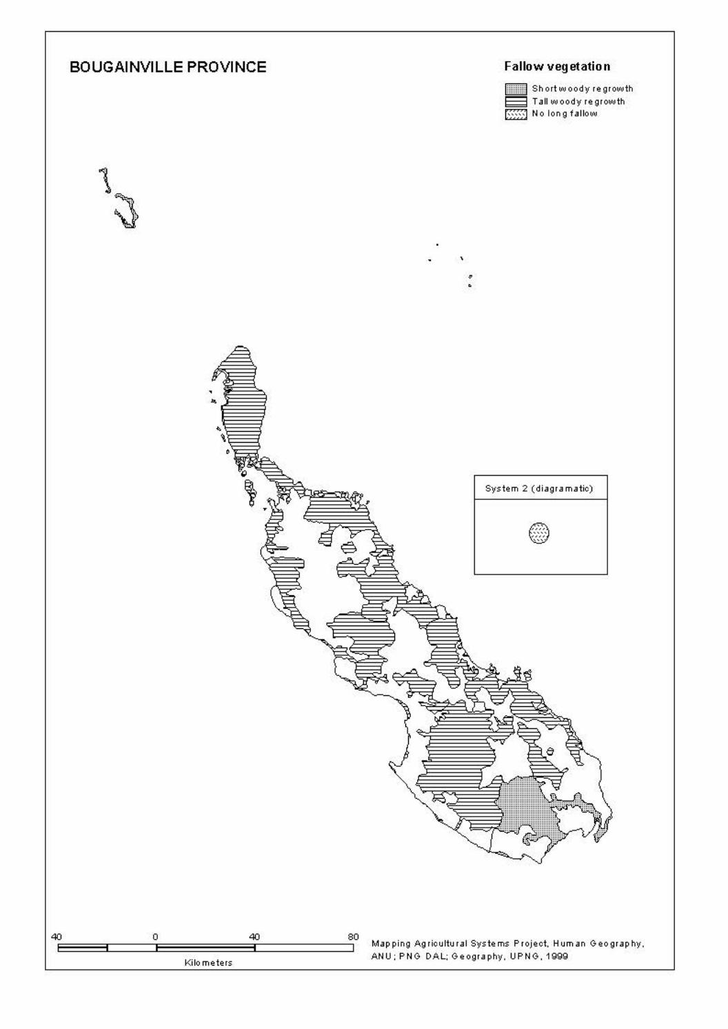
BOUGAINVILLE PROVINCE
40 0 40 80
Kilometers
' • •
Fallow vegetation
r:mmm1 Short woody re growth
"""""' ~ Tall woody re growth
[·=-=-=-=-] No Ion g fallow
System 2 (diagramatic)
Map ping Agricultural Systems Project, Hum an Geo gr ap hy, ANU: PNG DAL; Geography. UPNG. 1999

BOUGAINVILLE PROVINCE
• ..
40 0 40
Kilometers
80
• • •
Long fallow period
I::::: I No Ion g fallow ~ 1 to 4years EZ!Z!3 5 to 15 years
System 2 (diagramatic)
Map ping Agricultural Systems Project, Hum an Geo gr ap hy, ANU; PNG DAL: Geography, UPNG, 1999

BOUGAINVILLE PROVINCE
•
40E:::=::=:i::::====~o============40:i::::==========jso Kilometers
Numb er of plantings before fallow
lmmmnl 1 planting only ~ 3 to 5 plantings ~ More th an 40 plantings
•
• •
System 2 (diagramatic)
Map ping Agricultural Systems Project, Hum an Geo gr ap hy, ANU; PNG DAL: Geography, UPNG, 1999

BOUGAINVILLE PROVINCE
..
40E:=:=:=i:::::::]o=:=:=:=:=:=:=340[:::::::::::::::::so Kilometers
' • •
Intensity of land use Ratio of cropping period to fallow period
~Very low l!mmml Low E~5~5i High
System 2 (diagramatic)
@ , .
Map ping Agricultural Systems Project, Hum an Geo gr ap hy, ANU; PNG DAL: Geography, UPNG, 1999

BOUGAINVILLE PROVINCE
r;:;:;:;i ' Em E3 lllllllllD l1 .. ~ .. ]
40 0 40
Kilometers
Crop combinations
Most import ant crops Im po rt ant crops Coconut, swamp taro Cass av a, sweet potato Sweet potato Banana, cassava, coconut Sweet potato Banana, Chinese taro, co co nut Sweet potato Banana, coconut Sweet potato Banana, coconut. taro
• ' • •
System 2 (diagramatic)
80 Map ping Agricultural Systems Project, Hum an Geo gr ap hy, ANU; PNG DAL: Geography, UPNG, 1999

BOUGAINVILLE PROVINCE
40E:=:=:=i:::::::]o=:=:=:=:=:=:=340[:::::::::::::::::so Kilometers
' • •
Garden and crop segregation
I:::: :I Nose greg ation ~ Ga rd en segregation
System 2 (diagramatic)
Map ping Agricultural Systems Project, Hum an Geo gr ap hy, ANU; PNG DAL: Geography, UPNG, 1999

BOUGAINVILLE PROVINCE
• •
40 0 40 80
Kilometers
• • • •
Soil fertility mainten a nee
I:::: :I Long fallow on tv 8 Mulch
System 2 (diagramatic)
Map ping Agricultural Systems Project, Hum an Geo gr ap hy, ANU; PNG DAL: Geography, UPNG, 1999

BOUGAINVILLE PROVINCE
•
40 0 40 80
Kilometers
Soil tillage
1:::::1 None
• • •
• •
System 2 (diagramatic)
Map ping Agricultural Systems Project, Hum an Geo gr ap hy, ANU; PNG DAL: Geography, UPNG, 1999

BOUGAINVILLE PROVINCE
40E:=:=:=i:::::::10=============340C::::::::::::::::::80 Kilometers
. ' • •
Fallow clearing practices f:::::I Fallow cut and not burnt E3 Fallow cut and burnt
System 2 (diagramatic)
Map ping Agricultural Systems Project, Hum an Geo gr ap hy, ANU; PNG DAL: Geography, UPNG, 1999
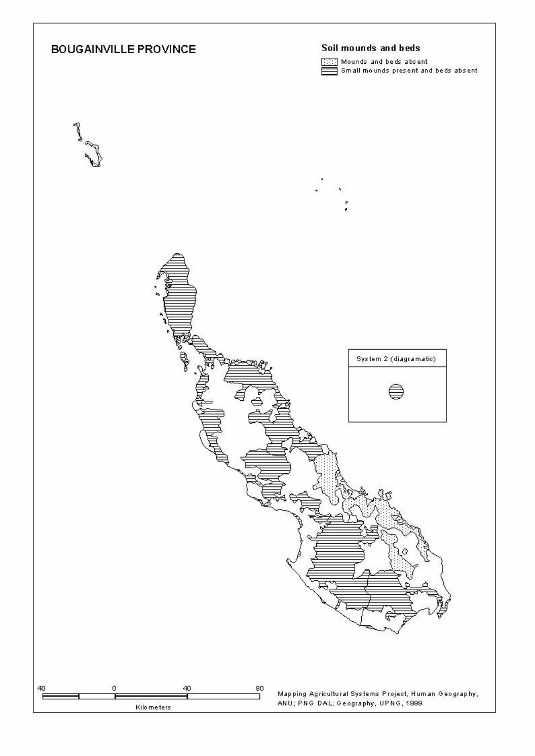
BOUGAINVILLE PROVINCE
40 0 40 80
Kilometers
Soil mounds and beds I:::: :I Mounds and beds absent ~ Sm all mounds present and beds absent
' • •
System 2 (diagramatic)
Map ping Agricultural Systems Project, Hum an Geo gr ap hy, ANU; PNG DAL: Geography, UPNG, 1999

BOUGAINVILLE PROVINCE
40E:::=::=:i::::====jo::=::=::=::=::=::=40:i::::==========~so Kilometers
Water man ag em ent techniques
~ Now ate r control
• ' • •
System 2 (diagramatic)
Map ping Agricultural Systems Project, Hum an Geo gr ap hy, ANU; PNG DAL: Geography, UPNG, 1999

BOUGAINVILLE PROVINCE
40E:=:=:=i:::::::]o=:=:=:=:=:=:=340[:::::::::::::::::so Kilometers
. ' • •
Cash income activities I:::: :I Nos ign ificant cash income
[[[[[) Cocoa ~ Cocoa. co co nut, fresh food t!t!t:J Coconut, fish
System 2 (diagramatic)
Map ping Agricultural Systems Project, Hum an Geo gr ap hy, ANU; PNG DAL: Geography, UPNG, 1999

BOUGAINVILLE PROVINCE
40E=:=:=::i:::::::::::Jo=:=:=:=:=:=:=340[:::::::::::::::::so
Kilometers
•
• •
Seas on ality of main food crops
I::::: I Nose as on al planting
System 2 (diagramatic)
Map ping Agricultural Systems Project, Hum an Geo gr ap hy, ANU: PNG DAL; Geography. UPNG. 1999

BOUGAINVILLE PROVINCE
40 0 40 80
Kilometers
,
• •
Population density Pe rs o ns per square kilometre
1:::::1below10 § 10· 24 -25-49 -50- 74 c:::J 75. gg .. above 99
System 2 (diagramatic)
•
Map ping Agricultural Systems Project, Hum an Geo gr ap hy, ANU: PNG DAL; Geography. UPNG. 1999

BOUGAINVILLE PROVINCE
40 0 40 80
Kilometers
• • '
• •
Population absent Percentage
System 2 (diagramatic)
Map ping Agricultural Systems Project, Hum an Geo gr ap hy, ANU: PNG DAL; Geography. UPNG. 1999

73
5. AGRICULTURAL SYSTEMS: DATA LISTING BY CODES The following tables list all of the information contained within the database in coded form. The codes are contained in Section 2, Database Structure, Definitions and Codes.

74

AGRICULTURAL SYSTEM DATA LISTING - CODES Province: 20 Bougainville
System Sub No. of Subsys Same sys Districts Census Divisions sys subsys extent oth prov
KEY Subsys Subsystem Same sys Same system in oth prov other province
75
2001 1 1 4 1 01 2002 1 1 4 1 01 2003 1 1 4 1 02-03-04 2004 1 1 4 1 03 2005 1 1 4 1-3 06-16 2006 1 1 4 1-2 05-07 2007 1 1 4 3 13-14-15 2008 1 1 4 2 07-08-09-10 2009 1 1 4 2 11-12

AGRICULTURAL SYSTEM DATA LISTING - CODES Province: 20 Bougainville
System Sub Area Population Altitude range m Slope Fallows sys km2 Total Abs Den Low High Veg Sht Per
KEY Subsys Subsystem Area km2 Area of System Population Fallows Total Resident population 1980 Veg Type of Fallow vegetation Abs Absent population (%) Sht Short fallows Den Population density (persons/km2) Per Long fallow period
76
2001 1 38 2991 13 79 0 20 2 4 0 1 2002 1 16 1607 26 100 0 3 1 7 1 0 2003 1 678 17739 18 26 0 80 1 5 0 2 2004 1 6 1423 35 237 0 20 1 4 1 1 2005 1 846 12500 4 15 0 700 5 5 0 2 2006 1 849 7834 8 9 0 500 5 5 0 2 2007 1 858 16557 5 19 0 1100 3 5 0 2 2008 1 1179 23122 4 20 0 950 2 5 0 2 2009 1 574 13528 5 24 0 800 5 4 0 1

AGRICULTURAL SYSTEM DATA LISTING - CODES Province: 20 Bougainville
System Sub Staple crops Narcotic sys Most import Important Present crops
KEY Subsys Subsystem
77
2001 1 11 02-06-13 02-04-05-06-11-12-13-14-15 2-4-5 2002 1 06-10 04-11 02-04-05-06-10-11-12-13 2003 1 11 02-06-13 02-04-05-06-11-13 2-4-5 2004 1 11 02-04-06 02-04-05-06-11-13 2-4 2005 1 11 02-06-13 02-04-05-06-11-13 2-4-5 2006 1 11 02-04-06 02-04-05-06-11-13-14 2-4-5 2007 1 11 02-05-06 02-05-06-11-13-14 2-4-5 2008 1 11 02-06 02-04-05-06-09-11-13-14-17 2-4-5 2009 1 11 02-05-06 02-05-06-11-13-14-17 2-4-5

AGRICULTURAL SYSTEM DATA LISTING - CODES Province: 20 Bougainville
System Sub Vegetable crops Fruit crops Nut crops sys
KEY Subsys Subsystem
78
2001 1 01-07-09-15-21-24-27 03-04-07-12-15-16-23-35 01-06-07-12-15 2002 1 01-21-24-27-30-32 03-04-05-12-15 01-07-12-15 2003 1 01-08-09-11-15-16-21-23-27-32 03-05-07-12-15-17-23 01-06-12 2004 1 01-08-09-11-15-16-19-21-32 03-05-06-07-12-15-17 01-06-07-12 2005 1 01-09-10-11-15-16-21-23-30-32 05-07-09-12-13-15-17-23 01-06-12 2006 1 01-08-09-10-11-15-16-21-27-32 05-06-07-09-12-15-17-23 01-06-12 2007 1 01-08-09-10-11-15-16-21-31 05-06-07-09-12-15-17-23 01-06-12 2008 1 01-08-09-10-11-15-16-21-23-27 05-07-12-13-15-17-23 01-06-12 2009 1 01-08-09-10-11-15-16-19-21-23 05-07-12-13-15-17-20-23 01-06-12

AGRICULTURAL SYSTEM DATA LISTING - CODES Province: 20 Bougainville
System Sub Segregation Crop Gard types Soil fertility maintenance techniques Sys Gar Crp Seq Mix H’ld Leg Tre Com Man Isl Sil Fer
KEY Subsys Subsystem Segregation Soil fertility maintenance techniques Gar Garden Leg Legume rotation Crp Crop Tre Planted tree fallow Com Compost Crop seq Crop sequences Man Animal manure Isl Island bed Gard types Garden types Sil Silt from floods Mix Mixed vegetable gardens Fer Inorganic fertilizer H'ld Household gardens
79
2001 1 2 1 0 0 2 0 0 0 0 0 0 0 2002 1 3 1 1 0 2 0 0 0 0 0 0 0 2003 1 2 1 0 0 0 0 0 0 0 0 0 0 2004 1 0 1 1 0 1 0 0 0 0 0 0 0 2005 1 1 1 1 0 0 0 0 0 0 0 0 0 2006 1 1 1 1 0 0 0 0 0 0 0 0 0 2007 1 1 1 0 0 0 0 0 0 0 0 0 0 2008 1 0 1 0 0 0 0 0 0 0 0 0 0 2009 1 0 1 1 0 0 0 0 0 0 0 0 0

AGRICULTURAL SYSTEM DATA LISTING - CODES Province: 20 Bougainville System Sub Management techniques sys Water Soil Fallow Other Irr Drn Pig Till Hol Bar Mul Mec Brn Cut Fen Stk
KEY Subsys Subsystem Management techniques Water management Fallow management Irr Irrigation Brn Burning of cut vegetation Drn Drainage Cut Fallow cut onto crops Soil management Other Pig Pigs placed in gardens Fen Fencing Till Tillage Stk Staking of crops Hol Deep holing (for yams) Bar Soil retention Mul Mulching Mec Mechanized soil tillage
80
2001 1 0 0 0 0 0 0 0 0 2 0 3 1 2002 1 0 0 0 0 0 0 2 0 1 0 0 0 2003 1 0 0 0 0 0 0 0 0 3 0 1 0 2004 1 0 0 0 0 0 0 0 0 2 0 0 0 2005 1 0 0 0 0 0 0 0 0 3 0 0 0 2006 1 0 0 0 0 0 0 0 0 3 0 0 0 2007 1 0 0 0 0 0 0 0 0 3 0 1 0 2008 1 0 0 0 0 0 0 0 0 3 0 1 0 2009 1 0 0 0 0 0 0 0 0 2 0 1 0

AGRICULTURAL SYSTEM DATA LISTING - CODES Province: 20 Bougainville
System Sub Management techniques Crop planting Cropping R value sys Soil mounds Garden beds seasonality intensity Vsm Sm Md Lge Sq Lg Maj Min
KEY Subsys Subsystem Management techniques Soil mounds Garden beds Vsm Very small Sq Square Sm Small Lg Long Md Medium Crop planting seasonality Lge Large Maj Dominant Min Other crops
81
2001 1 2 0 0 0 0 0 1 1 1 25 2002 1 0 2 0 0 0 0 0 0 6 100 2003 1 0 3 0 0 0 0 0 0 3 29 2004 1 0 3 0 0 0 0 0 0 3 57 2005 1 0 3 0 0 0 0 0 1 3 29 2006 1 0 3 0 0 0 0 0 0 3 29 2007 1 2 1 0 0 0 0 0 0 1 9 2008 1 1 3 0 0 0 0 1 1 3 29 2009 1 0 2 0 0 0 0 0 0 1 25
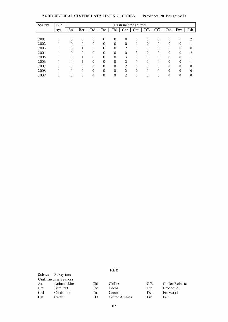
AGRICULTURAL SYSTEM DATA LISTING - CODES Province: 20 Bougainville
System Sub Cash income sources sys An Bet Crd Cat Chi Coc Cnt CfA CfR Crc Fwd Fsh
KEY Subsys Subsystem Cash Income Sources An Animal skins Chi Chillie CfR Coffee Robusta Bet Betel nut Coc Cocoa Crc Crocodile Crd Cardamom Cnt Coconut Fwd Firewood Cat Cattle CfA Coffee Arabica Fsh Fish
82
2001 1 0 0 0 0 0 0 1 0 0 0 0 2 2002 1 0 0 0 0 0 0 1 0 0 0 0 1 2003 1 0 1 0 0 0 2 3 0 0 0 0 0 2004 1 0 0 0 0 0 0 3 0 0 0 0 2 2005 1 0 1 0 0 0 3 1 0 0 0 0 1 2006 1 0 1 0 0 0 2 1 0 0 0 0 1 2007 1 0 0 0 0 0 2 0 0 0 0 0 0 2008 1 0 0 0 0 0 2 0 0 0 0 0 0 2009 1 0 0 0 0 0 2 0 0 0 0 0 0
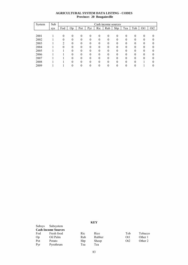
AGRICULTURAL SYSTEM DATA LISTING - CODES Province: 20 Bougainville
System Sub Cash income sources sys Fod Op Pot Pyr Ric Rub Shp Tea Tob Ot1 Ot2
KEY Subsys Subsystem Cash Income Sources Fod Fresh food Ric Rice Tob Tobacco Op Oil Palm Rub Rubber Ot1 Other 1 Pot Potato Shp Sheep Ot2 Other 2 Pyr Pyrethrum Tea Tea
83
2001 1 0 0 0 0 0 0 0 0 0 0 0 2002 1 0 0 0 0 0 0 0 0 0 0 0 2003 1 2 0 0 0 0 0 0 0 0 0 0 2004 1 0 0 0 0 0 0 0 0 0 0 0 2005 1 1 0 0 0 0 0 0 0 0 0 0 2006 1 1 0 0 0 0 0 0 0 0 0 0 2007 1 1 0 0 0 0 0 0 0 0 0 0 2008 1 1 0 0 0 0 0 0 0 0 1 0 2009 1 1 0 0 0 0 0 0 0 0 1 0

AGRICULTURAL SYSTEM DATA LISTING - CODES Province: 20 Bougainville
System Sub Survey 1 Survey 2 Survey 3 sys Date Period Sv Sv Date Period Sv Sv Date Period Sv Sv mth yr yrs tp in mth yr yrs tp in mth yr yrs tp in
KEY Subsys Subsystem H/W W. Humphrey/M. Woruba Sv tp Survey type MW M. Woruba Sv in Surveyor initials RMB R.M. Bourke
84
2001 1 09 92 - 3 H/W - - - - - - - - 2002 1 09 92 - 2 MW 01 92 - - MW - - - - 2003 1 06 96 - - RMB - - - - - - - - 2004 1 09 96 - - RMB - - - - - - - - 2005 1 12 80 - 2 RMB 08 96 - - RMB - - - - 2006 1 10 96 - - RMB - - - - - - - - 2007 1 12 80 - 2 RMB 08 96 - - RMB - - - - 2008 1 06 96 - - RMB - - - - - - - - 2009 1 08 96 - - RMB - - - - - - - -

85
6. LISTINGS OF RURAL VILLAGES (CENSUS UNITS) INDEXED TO AGRICULTURAL SYSTEMS
All rural village Census Units in the 1980 National Population Census which are locatable on either the 1980 or 1990 Census Maps are assigned to an Agricultural System. The village name, National Population Census identification codes (Province, District, Census Division, Census Unit), population and Agricultural System number for each village is held as a single record in a population database (AGPOP). District and Census Division codes for this Province are listed in Appendix A.2. This section provides three different listings from that database of rural villages indexed by Agricultural Systems: 6.1 Rural villages listed in census order (District, Census Division). 6.2 Rural villages listed in alphabetical order. 6.3 Rural villages listed by Agricultural System number (alphabetically within agricultural systems) with PNGRIS Resource Mapping Unit (RMU) numbers. Abbreviations used are:
Dist District name and number (see Appendix A.2) Div Census Division number (see Appendix A.2) Population 1980 National Population Census count of population in a Unit RMU Provincial Resource Mapping Unit number (PNGRIS) System Agricultural System number Village Census Unit name Unit Census Unit number

86

6.1 RURAL VILLAGES WITH AGRICULTURAL SYSTEM NUMBERS IN CENSUS ORDER
Province: 20 Bougainville
Village Population System Village Population System
87
DISTRICT 1 Buka
Division 1 Islands
1 AMOTU 241 2002
2 BALIL 335 2001
3 IANGAIN 121 2002
4 IESILA 86 2002
5 ILOSA 64 2002
6 IOLOHANAN 348 2002
7 KULIS 113 2001
8 LIHON 234 2001
9 MAPIRI 308 2001
10 MONTONIA 198 2001
11 NUGURIA 240 2002
12 NUKUTOA 507 2002
13 PIUL 143 2003
14 PORIWON 159 2001
15 ROGOS 124 2001
16 SALEPEN 128 2001
17 SIAKEN 128 2001
18 SIAR 136 2001
19 SIROT 69 2001
20 TANAHERAN 131 2001
21 TANAMALIT 205 2001
22 TARONGAL 157 2001
23 TEAH 199 2001
24 TERAUTUP 184 2001
25 YOTCHIBOL 183 2001
Division 2 Haku-Halia
1 ELUTUPAN 446 2003
2 HAGUS 326 2003
3 HAHALIS 677 2003
4 HANAHAN 642 2003
5 HANPAN 179 2003
6 IELELINA 321 2003
7 KETSKETS 338 2003
8 KOTOPAN 283 2003
9 LEMANKOA 1096 2003
10 LEMANMANU 869 2003
11 LONTIS 941 2003
12 TANDEKI 373 2003
13 TOHATSI 406 2003
Division 3 Punen
1 BARIKUA 337 2003
2 BEI 257 2003
3 BEIKUT 334 2003
4 GAGAN 585 2003
5 HAPAN 359 2003
6 HITAU 90 2004
7 KAHULE 162 2003
8 KOHINO 265 2003
9 KOHISO 410 2003
10 MATSUNGAN 214 2004
11 NOPAN 201 2003
12 NOVAH 335 2003
13 PETATS 588 2004
14 POKA 173 2003
15 PORORAN 357 2004
16 SAPANI 151 2003
17 TELATU 188 2003
18 TUNG 178 2003
19 YAPARU 174 2004
20 YEGITS 196 2003
Division 4 Buka Passage
1 ANAKEI 135 2003
2 CHUNDAWAN 152 2003
3 GOGOHEI NO.1 322 2003
4 GOGOHEI NO.2 266 2003
5 GOHI 238 2003
6 HANGAN 230 2003
7 IETA 368 2003
8 KATSUNKOVERI 174 2003
9 LONAHAN 670 2003
10 MALASANG 886 2003
11 MANOB 231 2003
12 PORAPORA 61 2003
13 RAMUNDATA 100 2003
14 RATSUA 72 2003
15 RURI 192 2003
16 SIARA 244 2003
17 SING 537 2003
18 SOROM 156 2003
19 SUHIN 215 2003
20 TAHAITAHAI 608 2003
21 TAPSANWARA 215 2003
22 TARBUT 289 2003
23 TOROTEI 149 2003
24 UMUM 58 2003
Division 5 Konua
1 AKOPAI 271 2006
2 AMUM 92 2006
3 ASTAPAI 212 2006
4 ATSILIMA 217 2006
5 AUKEI 127 2006
6 BETERAIO 269 2006
7 BOBOASI 54 2006
8 GOTON 94 2006
9 KAKAPARA 140 2006
10 KARARITU 73 2006
11 KAUBATEI 165 2006
12 KAUNA 332 2006
13 KAVIKI 249 2006
14 KEPUI 102 2006
15 KIAKARA 111 2006
16 KOATOROI 88 2006
17 KOPAI 123 2006
18 KOREPOVI 213 2006
19 KOSIPAI 79 2006
20 KUNAPOPO 114 2006
21 KUNOKOMOK 160 2006
22 KURUR 56 2006
23 LALUM 98 2006
24 LONKOGARI 96 2006
25 MAPISI 136 2006
26 MATITSORA 49 2006
27 MOSILAIE 68 2006
28 NAMBAROSI 89 2006

6.1 RURAL VILLAGES WITH AGRICULTURAL SYSTEM NUMBERS IN CENSUS ORDER
Province: 20 Bougainville
Village Population System Village Population System
88
29 PETSPETS 77 2006
30 POKUITO 87 2006
31 POPOHERAI 133 2006
32 PUTO 92 2006
33 RUKUSSIA 71 2006
34 SAPOSA 381 2006
35 SISIAPAI 173 2006
36 MUIRE 179 2006
37 TAIOF 445 2006
38 TOHEI 185 2006
39 TOSIAVI 109 2006
40 TOTOKI 146 2006
Division 6 Teop
1 ARAVIA 134 2005
2 DEOS 105 2005
3 HANTOBIN 120 2005
4 IAUN NO.1 44 2005
5 IAUN NO.2 151 2005
7 IRUE 90 2005
10 KOTOITA 179 2005
11 KOVANIS 160 2005
12 KUKURINA 91 2005
13 MELELUP 289 2005
14 MUTAHI 288 2005
15 NAMAKERIO 152 2005
16 NAMASIORA 186 2005
17 NAMATOA 320 2005
18 NEBLAHIU 156 2005
19 PATEAVEAVE 235 2005
20 POKAPA NO.1 279 2005
21 POKAPA NO.2 166 2005
22 PUSKOMBU 124 2005
24 RARIE 158 2005
25 ROMSIS 265 2005
26 SUANGU 80 2005
27 SUNVAHORA 282 2005
30 TEABES 52 2005
31 TEANANA 149 2005
32 TENDU 45 2005
33 TEOBUHIN NO.1 202 2005
34 TEOBUHIN NO.2 267 2005
35 TEOP 233 2005
36 TETAKUTS 48 2005
37 TOROBAI 62 2005
38 TOROKOKAPIA 265 2005
39 TSIKOT 75 2005
40 TSISIKO 290 2005
41 TSUNPETS 82 2005
42 TUMURI 110 2005
44 VAINANA 220 2005
45 VAROPA 203 2005
46 VASPOS 173 2005
47 WAUWANGINUVA 162 2005
DISTRICT 2 Buin
Division 7 Bagana
1 AGABAI 131 2008
2 ATANGATO 60 2006
3 BEREREKI 117 2008
4 JABA 148 2008
5 KABANAMI 53 2008
6 KARATO 137 2006
7 KAREKOPA 107 2006
8 KASIPEKE 50 2008
9 KAVAKAKATSU 67 2006
10 KENAIA 197 2006
11 KOIARE 156 2006
12 KORO 293 2008
13 KOROMAKETO 120 2006
14 KOROVI 165 2006
15 KUNIKA 149 2008
16 KUPON 201 2008
17 LABALAM 240 2008
18 LABONAMI 181 2008
19 LARUMA 92 2006
20 MAROWA 160 2006
21 MITSIKORI 91 2006
22 MOKOKOREU 190 2008
23 MOM 38 2006
24 MOMOGANARI 150 2008
25 NARINAI 107 2008
26 PANAM 258 2008
27 PIVA 99 2006
28 POLANAVIA 179 2008
29 RELA 230 2008
30 SIANEKI 203 2008
31 SIKOREWA 154 2008
32 TARUBA 193 2008
33 TSITO 80 2006
34 WARARIU 247 2008
35 WARUWARU 255 2008
36 WIWIARO 128 2008
Division 8 Basina
1 AGAWA 111 2008
2 AUMARI 93 2008
3 BAKORAM NO.1 312 2008
4 BAKORAM NO.2 92 2008
5 BERETEMBA 35 2008
6 BIROI 111 2008
7 BIROS 237 2008
8 BOKU 170 2008
9 KONAWA 34 2008
10 KONGARA 86 2008
11 LARENAI 211 2008
12 LAVORO 123 2008
13 LOPERE 135 2008
14 MABES 129 2008
15 MARIGA 90 2008
16 MASIWAKORE 135 2008
17 MASUNKE 36 2008
18 MATONA 67 2008
19 MAWERE 138 2008
20 MENDAI 169 2008
21 MEWA 137 2008
22 MEWARAKA 30 2008
23 MINGETA 43 2008
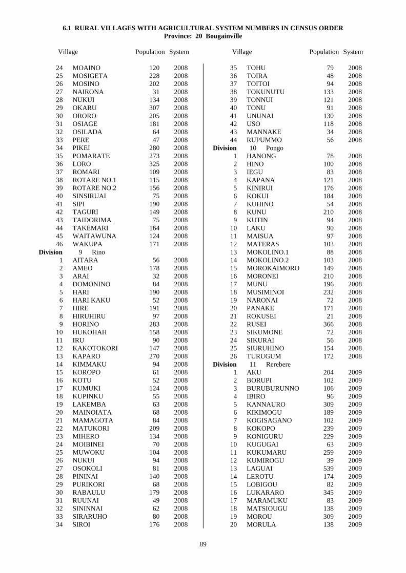
6.1 RURAL VILLAGES WITH AGRICULTURAL SYSTEM NUMBERS IN CENSUS ORDER
Province: 20 Bougainville
Village Population System Village Population System
89
24 MOAINO 120 2008
25 MOSIGETA 228 2008
26 MOSINO 202 2008
27 NAIRONA 31 2008
28 NUKUI 134 2008
29 OKARU 307 2008
30 ORORO 205 2008
31 OSIAGE 181 2008
32 OSILADA 64 2008
33 PERE 47 2008
34 PIKEI 280 2008
35 POMARATE 273 2008
36 LORO 325 2008
37 ROMARI 109 2008
38 ROTARE NO.1 115 2008
39 ROTARE NO.2 156 2008
40 SINSIRUAI 75 2008
41 SIPI 190 2008
42 TAGURI 149 2008
43 TAIDORIMA 75 2008
44 TAKEMARI 164 2008
45 WAITAWUNA 124 2008
46 WAKUPA 171 2008
Division 9 Rino
1 AITARA 56 2008
2 AMEO 178 2008
3 ARAI 32 2008
4 DOMONINO 84 2008
5 HARI 190 2008
6 HARI KAKU 52 2008
7 HIRE 191 2008
8 HIRUHIRU 97 2008
9 HORINO 283 2008
10 HUKOHAH 158 2008
11 IRU 90 2008
12 KAKOTOKORI 147 2008
13 KAPARO 270 2008
14 KIMMAKU 94 2008
15 KOROPO 61 2008
16 KOTU 52 2008
17 KUMUKI 124 2008
18 KUPINKU 55 2008
19 LAKEMBA 63 2008
20 MAINOIATA 68 2008
21 MAMAGOTA 84 2008
22 MATUKORI 209 2008
23 MIHERO 134 2008
24 MOIBINEI 70 2008
25 MUWOKU 104 2008
26 NUKUI 94 2008
27 OSOKOLI 81 2008
28 PININAI 140 2008
29 PURIKORI 68 2008
30 RABAULU 179 2008
31 RUUNAI 49 2008
32 SININNAI 62 2008
33 SIRARUHO 80 2008
34 SIROI 176 2008
35 TOHU 79 2008
36 TOIRA 48 2008
37 TOITOI 94 2008
38 TOKUNUTU 133 2008
39 TONNUI 121 2008
40 TONU 91 2008
41 UNUNAI 130 2008
42 USO 118 2008
43 MANNAKE 34 2008
44 RUPUMMO 56 2008
Division 10 Pongo
1 HANONG 78 2008
2 HINO 100 2008
3 IEGU 83 2008
4 KAPANA 121 2008
5 KINIRUI 176 2008
6 KOKUI 184 2008
7 KUHINO 54 2008
8 KUNU 210 2008
9 KUTIN 94 2008
10 LAKU 90 2008
11 MAISUA 97 2008
12 MATERAS 103 2008
13 MOKOLINO.1 88 2008
14 MOKOLINO.2 103 2008
15 MOROKAIMORO 149 2008
16 MORONEI 210 2008
17 MUNU 196 2008
18 MUSIMINOI 232 2008
19 NARONAI 72 2008
20 PANAKE 171 2008
21 ROKUSEI 21 2008
22 RUSEI 366 2008
23 SIKUMONE 72 2008
24 SIKURAI 56 2008
25 SIURUHINO 154 2008
26 TURUGUM 172 2008
Division 11 Rerebere
1 AKU 204 2009
2 BORUPI 102 2009
3 BURUBURUNNO 106 2009
4 IBIRO 96 2009
5 KANNAURO 309 2009
6 KIKIMOGU 189 2009
7 KOGISAGANO 102 2009
8 KOKOPO 239 2009
9 KONIGURU 229 2009
10 KUGUGAI 63 2009
11 KUKUMARU 259 2009
12 KUMIROGU 39 2009
13 LAGUAI 539 2009
14 LEROTU 174 2009
15 LOBIGOU 82 2009
16 LUKARARO 345 2009
17 MARAMUKU 83 2009
18 MATSIOUGU 138 2009
19 MOROU 309 2009
20 MORULA 138 2009

6.1 RURAL VILLAGES WITH AGRICULTURAL SYSTEM NUMBERS IN CENSUS ORDER
Province: 20 Bougainville
Village Population System Village Population System
90
21 MOUAKEI 111 2009
22 NABAKU 237 2009
23 NAKARO 130 2009
24 NAKOREI 174 2009
25 NUMAKEI 124 2009
26 OKOMO 116 2009
27 OMITARO 74 2009
28 OREMUTSI 114 2009
29 PARERONO 177 2009
30 PIARINO 117 2009
31 PIRURUINO 66 2009
32 SIALAU 22 2009
33 SIURU 126 2009
34 TARAPA 131 2008
35 TOGULEGU 26 2009
36 TOKUAKA 14 2009
37 TSIMBO 150 2009
38 TUARAGAI 124 2009
39 TUBARU 192 2009
40 TUBOBISOU 113 2009
41 TUGIOGU N0.1 & 2 369 2009
42 TUGIU 282 2009
43 TURIGAU 158 2009
44 UBANMOIUTO 143 2009
Division 12 Porobere
1 BOGISAGO 237 2009
2 BOTULAI 114 2007
3 IAMARU 104 2009
4 IPILAI 224 2009
5 IULA NO.1 189 2009
6 IULA NO.2 165 2009
7 IULA NO.3 99 2009
8 KAITU 133 2009
9 KAMOURO 270 2009
10 KEKEMONO 141 2007
11 KIKIBATSIOGU 98 2009
12 KOGU 95 2009
13 KOGUIKIRU 111 2009
14 KOMAI 32 2009
15 KOUKOUSINO 95 2007
16 KUGUIOGU 144 2009
17 KUKUMAI 150 2009
18 LAITARO 349 2009
19 LAKOVE 136 2009
20 LAMUAI 70 2009
21 LUAGUO 170 2009
22 LUILAU 134 2009
23 LUKAUKO 179 2009
24 MAIKA 136 2009
25 MALABITA 277 2009
26 MAMAROMINO NO.1 170 2009
27 MAMAROMINO NO.2 179 2009
28 MITUAI 87 2009
29 MOGOROI 188 2009
30 MORIU 95 2009
31 MUGUAI 184 2009
32 MUISURU 107 2009
33 NKUMU 50 2009
34 OKOIRAGU 126 2009
35 ORAVA 66 2009
36 OREMAI 307 2007
37 ORIA 182 2007
38 OROROI 112 2009
39 ORUMOI 82 2009
40 PAGUI 228 2007
41 PARERO 86 2009
42 PARIRO 455 2009
43 PAULOUKU 100 2009
44 PIRIRARO 123 2009
45 SADI 53 2009
46 SIUL 118 2009
47 SIURAI 116 2007
48 SULUKUNU 198 2007
49 TABAGO 127 2009
50 TAGURUAI 115 2009
51 TANTAREKI 233 2009
52 TUBARO 115 2009
53 TURUTAI 75 2009
54 UGUPAKOGU 76 2009
DISTRICT 3 Kieta
Division 13 Koromira-Kongara
1 AMAPONG 187 2007
2 AURUI 152 2007
3 BAKAKANI 156 2007
4 BANEI 181 2007
5 DAMBEWEI 51 2007
6 DAMAOSI 69 2008
7 DAMUNA 93 2007
8 DAMUNG 173 2008
9 DONGETA 222 2007
10 IORO 98 2007
11 ISINA 180 2007
12 KAMAROVI 151 2007
13 KAPIKAVE 236 2007
14 KARURU 72 2008
15 KEREMONA 150 2007
16 KURAI 207 2007
17 KURITAVE 187 2008
18 MANGONA 106 2007
19 MARILAU 110 2008
20 MARURA 134 2007
21 MINANI 84 2007
22 MORO 123 2008
23 MUAU 196 2008
24 MUNIAS 116 2007
25 NABUIA 64 2007
26 PEIWANA 147 2007
27 PIRENEIU 287 2007
28 PONDONA 68 2007
29 ROMEINA 122 2007
30 SIOROVI 132 2007
31 SIPURU 104 2008
32 SIPUREI 121 2007
33 SIROVAI 133 2008
34 TAKE 113 2007

6.1 RURAL VILLAGES WITH AGRICULTURAL SYSTEM NUMBERS IN CENSUS ORDER
Province: 20 Bougainville
Village Population System Village Population System
91
35 WIDA 100 2007
Division 14 Nasioi-Pirung
1 AMION 123 2007
2 ANGANAI 155 2007
3 ARAWA 231 2007
4 BAIRIMA 120 2007
5 BAKATUNG 195 2007
6 BAKAWORI 106 2007
7 BONAMUNG 155 2007
8 BUNUMANG 114 2007
9 DAITA 85 2007
10 DARUTUE NO.1 207 2007
11 DARUTUE NO.2 279 2007
12 DINGUNA 114 2007
13 DOKOTORO 89 2007
14 DONSIRO 208 2007
15 KARAKUNG 119 2007
16 KARIKIRA 135 2007
17 KOBUAN 79 2007
18 KOKADEI 133 2007
19 KOVENANG 102 2007
20 KUKA 57 2007
21 KUPEI 169 2007
22 MAKENIKO 64 2007
23 MAUANG 171 2007
24 MOINANG 87 2007
25 MONGONTORO 102 2007
26 MORANGISINA 166 2007
27 NASIOI 207 2007
28 PANKAMA 51 2007
29 PARAIANO 142 2007
30 PAVAIRE 166 2007
31 PIDIA 174 2007
32 POKPOK 303 2007
33 POMA 248 2007
34 POMAUA 134 2007
35 ROROVANA NO.1 246 2007
36 ROROVANA NO.2 264 2007
37 RUMBA 291 2007
38 SIAIE 142 2007
39 SIBUNA 112 2007
40 SINKAI 64 2007
41 SIPA 50 2007
42 SIROMBA 117 2007
43 SIROMBANA 106 2007
44 TAULAPELIA 47 2007
45 TAVIDUA 112 2007
46 TOBOROI 141 2007
47 TOPINA 153 2007
48 UNABATO 103 2007
Division 15 Ioro-Eivo
1 ALAKABAU 64 2007
2 ATAMO 413 2007
3 BOIRA 239 2007
4 BORUMAI 198 2007
5 BOVE 225 2007
6 DAPERA 431 2007
7 DARENAI 326 2008
8 DARU 112 2007
9 GUAVA 131 2008
10 IRANG 274 2008
11 KARNIVITU 326 2007
12 KOKOMATE 127 2008
13 KOKORE 396 2008
14 KOPANI 533 2007
15 KOPIKIRI 172 2007
16 KORPEI 420 2007
17 MAINOKI 346 2008
18 MORONI 89 2007
19 MUMURAI 318 2008
20 MUSINAU 235 2008
21 NASIWOIWA 243 2007
22 ONOVI 238 2008
23 ORAMI 333 2008
24 PAKIA 275 2007
25 PANKA 172 2008
26 PIAWORA 166 2008
27 PISINAU 225 2008
28 SIREONDJI 174 2007
29 SIROWAI 172 2007
30 SUIEMA(PAURA) 197 2007
31 TARARA 152 2007
32 VITO 145 2007
Division 16 Rotokas
1 BULISTORO 231 2005
2 IBU 203 2005
3 INUS 112 2005
4 IPARAKA 312 2005
5 KAKARAPAIA 303 2005
6 KOROBORA 244 2005
7 KUSI NO.1 & 2 133 2005
8 MAPEARO 327 2005
9 NUPATORO NO.1 & 2 405 2005
10 OKOBUPAIA 215 2005
11 OSOWAIPA 162 2005
12 OWAIWAIPA 213 2005
13 PIPIAIA 281 2005
14 POKAIA 245 2005
15 RURUVU 246 2005
16 SIRORIPAIA 255 2005
17 SISIVI 310 2006
18 TEARAKA 283 2005
19 TEPEROI 135 2005
20 TOGARAO 458 2005
21 TOKAI 325 2005
22 TURIMA 193 2005
23 TUTUPAIA 318 2005
24 TUVIA 209 2005

92

6.2 RURAL VILLAGES WITH AGRICULTURAL SYSTEM NUMBERS IN ALPHABETICAL ORDER Province: 20 Bougainville
Village Dist Div Unit System Village Dist Div Unit System
93
AGABAI 2 7 1 2008 AGAWA 2 8 1 2008 AITARA 2 9 1 2008 AKOPAI 1 5 1 2006 AKU 2 11 1 2009 ALAKABAU 3 15 1 2007 AMAPONG 3 13 1 2007 AMEO 2 9 2 2008 AMION 3 14 1 2007 AMOTU 1 1 1 2002 AMUM 1 5 2 2006 ANAKEI 1 4 1 2003 ANGANAI 3 14 2 2007 ARAI 2 9 3 2008 ARAVIA 1 6 1 2005 ARAWA 3 14 3 2007 ASTAPAI 1 5 3 2006 ATAMO 3 15 2 2007 ATANGATO 2 7 2 2006 ATSILIMA 1 5 4 2006 AUKEI 1 5 5 2006 AUMARI 2 8 2 2008 AURUI 3 13 2 2007 BAIRIMA 3 14 4 2007 BAKAKANI 3 13 3 2007 BAKATUNG 3 14 5 2007 BAKAWORI 3 14 6 2007 BAKORAM NO.1 2 8 3 2008 BAKORAM NO.2 2 8 4 2008 BALIL 1 1 2 2001 BANEI 3 13 4 2007 BARIKUA 1 3 1 2003 BEI 1 3 2 2003 BEIKUT 1 3 3 2003 BEREREKI 2 7 3 2008 BERETEMBA 2 8 5 2008 BETERAIO 1 5 6 2006 BIROI 2 8 6 2008 BIROS 2 8 7 2008 BOBOASI 1 5 7 2006 BOGISAGO 2 12 1 2009 BOIRA 3 15 3 2007 BOKU 2 8 8 2008 BONAMUNG 3 14 7 2007 BORUMAI 3 15 4 2007 BORUPI 2 11 2 2009 BOTULAI 2 12 2 2007 BOVE 3 15 5 2007 BULISTORO 3 16 1 2005 BUNUMANG 3 14 8 2007 BURUBURUNNO 2 11 3 2009 CHUNDAWAN 1 4 2 2003 DAITA 3 14 9 2007 DAMAOSI 3 13 6 2008 DAMBEWEI 3 13 5 2007
DAMUNA 3 13 7 2007 DAMUNG 3 13 8 2008 DAPERA 3 15 6 2007 DARENAI 3 15 7 2008 DARU 3 15 8 2007 DARUTUE NO.1 3 14 10 2007 DARUTUE NO.2 3 14 11 2007 DEOS 1 6 2 2005 DINGUNA 3 14 12 2007 DOKOTORO 3 14 13 2007 DOMONINO 2 9 4 2008 DONGETA 3 13 9 2007 DONSIRO 3 14 14 2007 ELUTUPAN 1 2 1 2003 GAGAN 1 3 4 2003 GOGOHEI NO.1 1 4 3 2003 GOGOHEI NO.2 1 4 4 2003 GOHI 1 4 5 2003 GOTON 1 5 8 2006 GUAVA 3 15 9 2008 HAGUS 1 2 2 2003 HAHALIS 1 2 3 2003 HANAHAN 1 2 4 2003 HANGAN 1 4 6 2003 HANONG 2 10 1 2008 HANPAN 1 2 5 2003 HANTOBIN 1 6 3 2005 HAPAN 1 3 5 2003 HARI 2 9 5 2008 HARI KAKU 2 9 6 2008 HINO 2 10 2 2008 HIRE 2 9 7 2008 HIRUHIRU 2 9 8 2008 HITAU 1 3 6 2004 HORINO 2 9 9 2008 HUKOHAH 2 9 10 2008 IAMARU 2 12 3 2009 IANGAIN 1 1 3 2002 IAUN NO.1 1 6 4 2005 IAUN NO.2 1 6 5 2005 IBIRO 2 11 4 2009 IBU 3 16 2 2005 IEGU 2 10 3 2008 IELELINA 1 2 6 2003 IESILA 1 1 4 2002 IETA 1 4 7 2003 ILOSA 1 1 5 2002 INUS 3 16 3 2005 IOLOHANAN 1 1 6 2002 IORO 3 13 10 2007 IPARAKA 3 16 4 2005 IPILAI 2 12 4 2009 IRANG 3 15 10 2008 IRU 2 9 11 2008

6.2 RURAL VILLAGES WITH AGRICULTURAL SYSTEM NUMBERS IN ALPHABETICAL ORDER Province: 20 Bougainville
Village Dist Div Unit System Village Dist Div Unit System
94
IRUE 1 6 7 2005 ISINA 3 13 11 2007 IULA NO.1 2 12 5 2009 IULA NO.2 2 12 6 2009 IULA NO.3 2 12 7 2009 JABA 2 7 4 2008 KABANAMI 2 7 5 2008 KAHULE 1 3 7 2003 KAITU 2 12 8 2009 KAKAPARA 1 5 9 2006 KAKARAPAIA 3 16 5 2005 KAKOTOKORI 2 9 12 2008 KAMAROVI 3 13 12 2007 KAMOURO 2 12 9 2009 KANNAURO 2 11 5 2009 KAPANA 2 10 4 2008 KAPARO 2 9 13 2008 KAPIKAVE 3 13 13 2007 KARAKUNG 3 14 15 2007 KARARITU 1 5 10 2006 KARATO 2 7 6 2006 KAREKOPA 2 7 7 2006 KARIKIRA 3 14 16 2007 KARNIVITU 3 15 11 2007 KARURU 3 13 14 2008 KASIPEKE 2 7 8 2008 KATSUNKOVERI 1 4 8 2003 KAUBATEI 1 5 11 2006 KAUNA 1 5 12 2006 KAVAKAKATSU 2 7 9 2006 KAVIKI 1 5 13 2006 KEKEMONO 2 12 10 2007 KENAIA 2 7 10 2006 KEPUI 1 5 14 2006 KEREMONA 3 13 15 2007 KETSKETS 1 2 7 2003 KIAKARA 1 5 15 2006 KIKIBATSIOGU 2 12 11 2009 KIKIMOGU 2 11 6 2009 KIMMAKU 2 9 14 2008 KINIRUI 2 10 5 2008 KOATOROI 1 5 16 2006 KOBUAN 3 14 17 2007 KOGISAGANO 2 11 7 2009 KOGU 2 12 12 2009 KOGUIKIRU 2 12 13 2009 KOHINO 1 3 8 2003 KOHISO 1 3 9 2003 KOIARE 2 7 11 2006 KOKADEI 3 14 18 2007 KOKOMATE 3 15 12 2008 KOKOPO 2 11 8 2009 KOKORE 3 15 13 2008 KOKUI 2 10 6 2008 KOMAI 2 12 14 2009 KONAWA 2 8 9 2008
KONGARA 2 8 10 2008 KONIGURU 2 11 9 2009 KOPAI 1 5 17 2006 KOPANI 3 15 14 2007 KOPIKIRI 3 15 15 2007 KOREPOVI 1 5 18 2006 KORO 2 7 12 2008 KOROBORA 3 16 6 2005 KOROMAKETO 2 7 13 2006 KOROPO 2 9 15 2008 KOROVI 2 7 14 2006 KORPEI 3 15 16 2007 KOSIPAI 1 5 19 2006 KOTOITA 1 6 10 2005 KOTOPAN 1 2 8 2003 KOTU 2 9 16 2008 KOUKOUSINO 2 12 15 2007 KOVANIS 1 6 11 2005 KOVENANG 3 14 19 2007 KUGUGAI 2 11 10 2009 KUGUIOGU 2 12 16 2009 KUHINO 2 10 7 2008 KUKA 3 14 20 2007 KUKUMAI 2 12 17 2009 KUKUMARU 2 11 11 2009 KUKURINA 1 6 12 2005 KULIS 1 1 7 2001 KUMIROGU 2 11 12 2009 KUMUKI 2 9 17 2008 KUNAPOPO 1 5 20 2006 KUNIKA 2 7 15 2008 KUNOKOMOK 1 5 21 2006 KUNU 2 10 8 2008 KUPEI 3 14 21 2007 KUPINKU 2 9 18 2008 KUPON 2 7 16 2008 KURAI 3 13 16 2007 KURITAVE 3 13 17 2008 KURUR 1 5 22 2006 KUSI NO.1 & 2 3 16 7 2005 KUTIN 2 10 9 2008 LABALAM 2 7 17 2008 LABONAMI 2 7 18 2008 LAGUAI 2 11 13 2009 LAITARO 2 12 18 2009 LAKEMBA 2 9 19 2008 LAKOVE 2 12 19 2009 LAKU 2 10 10 2008 LALUM 1 5 23 2006 LAMUAI 2 12 20 2009 LARENAI 2 8 11 2008 LARUMA 2 7 19 2006 LAVORO 2 8 12 2008 LEMANKOA 1 2 9 2003 LEMANMANU 1 2 10 2003 LEROTU 2 11 14 2009 LIHON 1 1 8 2001

6.2 RURAL VILLAGES WITH AGRICULTURAL SYSTEM NUMBERS IN ALPHABETICAL ORDER Province: 20 Bougainville
Village Dist Div Unit System Village Dist Div Unit System
95
LOBIGOU 2 11 15 2009 LONAHAN 1 4 9 2003 LONKOGARI 1 5 24 2006 LONTIS 1 2 11 2003 LOPERE 2 8 13 2008 LORO 2 8 36 2008 LUAGUO 2 12 21 2009 LUILAU 2 12 22 2009 LUKARARO 2 11 16 2009 LUKAUKO 2 12 23 2009 MABES 2 8 14 2008 MAIKA 2 12 24 2009 MAINOIATA 2 9 20 2008 MAINOKI 3 15 17 2008 MAISUA 2 10 11 2008 MAKENIKO 3 14 22 2007 MALABITA 2 12 25 2009 MALASANG 1 4 10 2003 MAMAGOTA 2 9 21 2008 MAMAROMINO NO.1 2 12 26 2009 MAMAROMINO NO.2 2 12 27 2009 MANGONA 3 13 18 2007 MANNAKE 2 9 43 2008 MANOB 1 4 11 2003 MAPEARO 3 16 8 2005 MAPIRI 1 1 9 2001 MAPISI 1 5 25 2006 MARAMUKU 2 11 17 2009 MARIGA 2 8 15 2008 MARILAU 3 13 19 2008 MAROWA 2 7 20 2006 MARURA 3 13 20 2007 MASIWAKORE 2 8 16 2008 MASUNKE 2 8 17 2008 MATERAS 2 10 12 2008 MATITSORA 1 5 26 2006 MATONA 2 8 18 2008 MATSIOUGU 2 11 18 2009 MATSUNGAN 1 3 10 2004 MATUKORI 2 9 22 2008 MAUANG 3 14 23 2007 MAWERE 2 8 19 2008 MELELUP 1 6 13 2005 MENDAI 2 8 20 2008 MEWA 2 8 21 2008 MEWARAKA 2 8 22 2008 MIHERO 2 9 23 2008 MINANI 3 13 21 2007 MINGETA 2 8 23 2008 MITSIKORI 2 7 21 2006 MITUAI 2 12 28 2009 MOAINO 2 8 24 2008 MOGOROI 2 12 29 2009 MOIBINEI 2 9 24 2008 MOINANG 3 14 24 2007 MOKOKOREU 2 7 22 2008 MOKOLI NO.1 2 10 13 2008
MOKOLI NO.2 2 10 14 2008 MOM 2 7 23 2006 MOMOGANARI 2 7 24 2008 MONGONTORO 3 14 25 2007 MONTONIA 1 1 10 2001 MORANGISINA 3 14 26 2007 MORIU 2 12 30 2009 MORO 3 13 22 2008 MOROKAIMORO 2 10 15 2008 MORONEI 2 10 16 2008 MORONI 3 15 18 2007 MOROU 2 11 19 2009 MORULA 2 11 20 2009 MOSIGETA 2 8 25 2008 MOSILAIE 1 5 27 2006 MOSINO 2 8 26 2008 MOUAKEI 2 11 21 2009 MUAU 3 13 23 2008 MUGUAI 2 12 31 2009 MUIRE 1 5 36 2006 MUISURU 2 12 32 2009 MUMURAI 3 15 19 2008 MUNIAS 3 13 24 2007 MUNU 2 10 17 2008 MUSIMINOI 2 10 18 2008 MUSINAU 3 15 20 2008 MUTAHI 1 6 14 2005 MUWOKU 2 9 25 2008 NABAKU 2 11 22 2009 NABUIA 3 13 25 2007 NAIRONA 2 8 27 2008 NAKARO 2 11 23 2009 NAKOREI 2 11 24 2009 NAMAKERIO 1 6 15 2005 NAMASIORA 1 6 16 2005 NAMATOA 1 6 17 2005 NAMBAROSI 1 5 28 2006 NARINAI 2 7 25 2008 NARONAI 2 10 19 2008 NASIOI 3 14 27 2007 NASIWOIWA 3 15 21 2007 NEBLAHIU 1 6 18 2005 NKUMU 2 12 33 2009 NOPAN 1 3 11 2003 NOVAH 1 3 12 2003 NUGURIA 1 1 11 2002 NUKUI 2 8 28 2008 NUKUI 2 9 26 2008 NUKUTOA 1 1 12 2002 NUMAKEI 2 11 25 2009 NUPATORO NO.1 & 2 3 16 9 2005 OKARU 2 8 29 2008 OKOBUPAIA 3 16 10 2005 OKOIRAGU 2 12 34 2009 OKOMO 2 11 26 2009 OMITARO 2 11 27 2009

6.2 RURAL VILLAGES WITH AGRICULTURAL SYSTEM NUMBERS IN ALPHABETICAL ORDER Province: 20 Bougainville
Village Dist Div Unit System Village Dist Div Unit System
96
ONOVI 3 15 22 2008 ORAMI 3 15 23 2008 ORAVA 2 12 35 2009 OREMAI 2 12 36 2007 OREMUTSI 2 11 28 2009 ORIA 2 12 37 2007 ORORO 2 8 30 2008 OROROI 2 12 38 2009 ORUMOI 2 12 39 2009 OSIAGE 2 8 31 2008 OSILADA 2 8 32 2008 OSOKOLI 2 9 27 2008 OSOWAIPA 3 16 11 2005 OWAIWAIPA 3 16 12 2005 PAGUI 2 12 40 2007 PAKIA 3 15 24 2007 PANAKE 2 10 20 2008 PANAM 2 7 26 2008 PANKA 3 15 25 2008 PANKAMA 3 14 28 2007 PARAIANO 3 14 29 2007 PARERO 2 12 41 2009 PARERONO 2 11 29 2009 PARIRO 2 12 42 2009 PATEAVEAVE 1 6 19 2005 PAULOUKU 2 12 43 2009 PAVAIRE 3 14 30 2007 PEIWANA 3 13 26 2007 PERE 2 8 33 2008 PETATS 1 3 13 2004 PETSPETS 1 5 29 2006 PIARINO 2 11 30 2009 PIAWORA 3 15 26 2008 PIDIA 3 14 31 2007 PIKEI 2 8 34 2008 PININAI 2 9 28 2008 PIPIAIA 3 16 13 2005 PIRENEIU 3 13 27 2007 PIRIRARO 2 12 44 2009 PIRURUINO 2 11 31 2009 PISINAU 3 15 27 2008 PIUL 1 1 13 2003 PIVA 2 7 27 2006 POKA 1 3 14 2003 POKAIA 3 16 14 2005 POKAPA NO.1 1 6 20 2005 POKAPA NO.2 1 6 21 2005 POKPOK 3 14 32 2007 POKUITO 1 5 30 2006 POLANAVIA 2 7 28 2008 POMA 3 14 33 2007 POMARATE 2 8 35 2008 POMAUA 3 14 34 2007 PONDONA 3 13 28 2007 POPOHERAI 1 5 31 2006 PORAPORA 1 4 12 2003 PORIWON 1 1 14 2001
PORORAN 1 3 15 2004 PURIKORI 2 9 29 2008 PUSKOMBU 1 6 22 2005 PUTO 1 5 32 2006 RABAULU 2 9 30 2008 RAMUNDATA 1 4 13 2003 RARIE 1 6 24 2005 RATSUA 1 4 14 2003 RELA 2 7 29 2008 ROGOS 1 1 15 2001 ROKUSEI 2 10 21 2008 ROMARI 2 8 37 2008 ROMEINA 3 13 29 2007 ROMSIS 1 6 25 2005 ROROVANA NO.1 3 14 35 2007 ROROVANA NO.2 3 14 36 2007 ROTARE NO.1 2 8 38 2008 ROTARE NO.2 2 8 39 2008 RUKUSSIA 1 5 33 2006 RUMBA 3 14 37 2007 RUPUMMO 2 9 44 2008 RURI 1 4 15 2003 RURUVU 3 16 15 2005 RUSEI 2 10 22 2008 RUUNAI 2 9 31 2008 SADI 2 12 45 2009 SALEPEN 1 1 16 2001 SAPANI 1 3 16 2003 SAPOSA 1 5 34 2006 SIAIE 3 14 38 2007 SIAKEN 1 1 17 2001 SIALAU 2 11 32 2009 SIANEKI 2 7 30 2008 SIAR 1 1 18 2001 SIARA 1 4 16 2003 SIBUNA 3 14 39 2007 SIKOREWA 2 7 31 2008 SIKUMONE 2 10 23 2008 SIKURAI 2 10 24 2008 SING 1 4 17 2003 SININNAI 2 9 32 2008 SINKAI 3 14 40 2007 SINSIRUAI 2 8 40 2008 SIOROVI 3 13 30 2007 SIPA 3 14 41 2007 SIPI 2 8 41 2008 SIPUREI 3 13 32 2007 SIPURU 3 13 31 2008 SIRARUHO 2 9 33 2008 SIREONDJI 3 15 28 2007 SIROI 2 9 34 2008 SIROMBA 3 14 42 2007 SIROMBANA 3 14 43 2007 SIRORIPAIA 3 16 16 2005 SIROT 1 1 19 2001 SIROVAI 3 13 33 2008

6.2 RURAL VILLAGES WITH AGRICULTURAL SYSTEM NUMBERS IN ALPHABETICAL ORDER Province: 20 Bougainville
Village Dist Div Unit System Village Dist Div Unit System
97
SIROWAI 3 15 29 2007 SISIAPAI 1 5 35 2006 SISIVI 3 16 17 2006 SIUL 2 12 46 2009 SIURAI 2 12 47 2007 SIURU 2 11 33 2009 SIURUHINO 2 10 25 2008 SOROM 1 4 18 2003 SUANGU 1 6 26 2005 SUHIN 1 4 19 2003 SUIEMA(PAURA) 3 15 30 2007 SULUKUNU 2 12 48 2007 SUNVAHORA 1 6 27 2005 TABAGO 2 12 49 2009 TAGURI 2 8 42 2008 TAGURUAI 2 12 50 2009 TAHAITAHAI 1 4 20 2003 TAIDORIMA 2 8 43 2008 TAIOF 1 5 37 2006 TAKE 3 13 34 2007 TAKEMARI 2 8 44 2008 TANAHERAN 1 1 20 2001 TANAMALIT 1 1 21 2001 TANDEKI 1 2 12 2003 TANTAREKI 2 12 51 2009 TAPSANWARA 1 4 21 2003 TARAPA 2 11 34 2008 TARARA 3 15 31 2007 TARBUT 1 4 22 2003 TARONGAL 1 1 22 2001 TARUBA 2 7 32 2008 TAULAPELIA 3 14 44 2007 TAVIDUA 3 14 45 2007 TEABES 1 6 30 2005 TEAH 1 1 23 2001 TEANANA 1 6 31 2005 TEARAKA 3 16 18 2005 TELATU 1 3 17 2003 TENDU 1 6 32 2005 TEOBUHIN NO.1 1 6 33 2005 TEOBUHIN NO.2 1 6 34 2005 TEOP 1 6 35 2005 TEPEROI 3 16 19 2005 TERAUTUP 1 1 24 2001 TETAKUTS 1 6 36 2005 TOBOROI 3 14 46 2007 TOGARAO 3 16 20 2005 TOGULEGU 2 11 35 2009 TOHATSI 1 2 13 2003 TOHEI 1 5 38 2006 TOHU 2 9 35 2008 TOIRA 2 9 36 2008 TOITOI 2 9 37 2008 TOKAI 3 16 21 2005 TOKUAKA 2 11 36 2009 TOKUNUTU 2 9 38 2008 TONNUI 2 9 39 2008
TONU 2 9 40 2008 TOPINA 3 14 47 2007 TOROBAI 1 6 37 2005 TOROKOKAPIA 1 6 38 2005 TOROTEI 1 4 23 2003 TOSIAVI 1 5 39 2006 TOTOKI 1 5 40 2006 TSIKOT 1 6 39 2005 TSIMBO 2 11 37 2009 TSISIKO 1 6 40 2005 TSITO 2 7 33 2006 TSUNPETS 1 6 41 2005 TUARAGAI 2 11 38 2009 TUBARO 2 12 52 2009 TUBARU 2 11 39 2009 TUBOBISOU 2 11 40 2009 TUGIOGU NO.1&2 2 11 41 2009 TUGIU 2 11 42 2009 TUMURI 1 6 42 2005 TUNG 1 3 18 2003 TURIGAU 2 11 43 2009 TURIMA 3 16 22 2005 TURUGUM 2 10 26 2008 TURUTAI 2 12 53 2009 TUTUPAIA 3 16 23 2005 TUVIA 3 16 24 2005 UBANMOIUTO 2 11 44 2009 UGUPAKOGU 2 12 54 2009 UMUM 1 4 24 2003 UNABATO 3 14 48 2007 UNUNAI 2 9 41 2008 USO 2 9 42 2008 VAINANA 1 6 44 2005 VAROPA 1 6 45 2005 VASPOS 1 6 46 2005 VITO 3 15 32 2007 WAITAWUNA 2 8 45 2008 WAKUPA 2 8 46 2008 WARARIU 2 7 34 2008 WARUWARU 2 7 35 2008 WAUWANGINUVA 1 6 47 2005 WIDA 3 13 35 2007 WIWIARO 2 7 36 2008 YAPARU 1 3 19 2004 YEGITS 1 3 20 2003 YOTCHIBOL 1 1 25 2001

98

6.3 RURAL VILLAGES LISTED BY AGRICULTURAL SYSTEM Province: 20 Bougainville
Village Dist Div Unit RMU Village Dist Div Unit RMU
99
SYSTEM 2001
BALIL 1 1 2 2
KULIS 1 1 7 2
LIHON 1 1 8 2
MAPIRI 1 1 9 2
MONTONIA 1 1 10 1
PORIWON 1 1 14 2
ROGOS 1 1 15 1
SALEPEN 1 1 16 2
SIAKEN 1 1 17 2
SIAR 1 1 18 2
SIROT 1 1 19 2
TANAHERAN 1 1 20 2
TANAMALIT 1 1 21 2
TARONGAL 1 1 22 2
TEAH 1 1 23 1
TERAUTUP 1 1 24 2
YOTCHIBOL 1 1 25 2
SYSTEM 2002
AMOTU 1 1 1 137
IANGAIN 1 1 3 129
IESILA 1 1 4 129
ILOSA 1 1 5 129
IOLOHANAN 1 1 6 129
NUGURIA 1 1 11 127
NUKUTOA 1 1 12 128
SYSTEM 2003
ANAKEI 1 4 1 16
BARIKUA 1 3 1 4
BEI 1 3 2 130
BEIKUT 1 3 3 4
CHUNDAWAN 1 4 2 16
ELUTUPAN 1 2 1 3
GAGAN 1 3 4 4
GOGOHEI NO.1 1 4 3 3
GOGOHEI NO.2 1 4 4 3
GOHI 1 4 5 16
HAGUS 1 2 2 3
HAHALIS 1 2 3 3
HANAHAN 1 2 4 3
HANGAN 1 4 6 3
HANPAN 1 2 5 3
HAPAN 1 3 5 4
IELELINA 1 2 6 3
IETA 1 4 7 3
KAHULE 1 3 7 130
KATSUNKOVERI 1 4 8 16
KETSKETS 1 2 7 3
KOHINO 1 3 8 4
KOHISO 1 3 9 4
KOTOPAN 1 2 8 3
LEMANKOA 1 2 9 3
LEMANMANU 1 2 10 3
LONAHAN 1 4 9 3
LONTIS 1 2 11 3
MALASANG 1 4 10 3
MANOB 1 4 11 16
NOPAN 1 3 11 4
NOVAH 1 3 12 8
PIUL 1 1 13 129
POKA 1 3 14 130
PORAPORA 1 4 12 19
RAMUNDATA 1 4 13 16
RATSUA 1 4 14 140
RURI 1 4 15 16
SAPANI 1 3 16 4
SIARA 1 4 16 16
SING 1 4 17 3
SOROM 1 4 18 16
SUHIN 1 4 19 3
TAHAITAHAI 1 4 20 3
TANDEKI 1 2 12 3
TAPSANWARA 1 4 21 16
TARBUT 1 4 22 16
TELATU 1 3 17 3
TOHATSI 1 2 13 3
TOROTEI 1 4 23 16
TUNG 1 3 18 130
UMUM 1 4 24 16
YEGITS 1 3 20 130
SYSTEM 2004
HITAU 1 3 6 126
MATSUNGAN 1 3 10 120
PETATS 1 3 13 120
PORORAN 1 3 15 7
YAPARU 1 3 19 7
SYSTEM 2005
ARAVIA 1 6 1 26
BULISTORO 3 16 1 50
DEOS 1 6 2 21
HANTOBIN 1 6 3 19
IAUN NO.1 1 6 4 23
IAUN NO.2 1 6 5 23
IBU 3 16 2 50
INUS 3 16 3 53
IPARAKA 3 16 4 56
IRUE 1 6 7 141
KAKARAPAIA 3 16 5 50
KOROBORA 3 16 6 51
KOTOITA 1 6 10 52
KOVANIS 1 6 11 22
KUKURINA 1 6 12 19
KUSI NO.1 & 2 3 16 7 25
MAPEARO 3 16 8 57
MELELUP 1 6 13 25
MUTAHI 1 6 14 25
NAMAKERIO 1 6 15 143
NAMASIORA 1 6 16 19
NAMATOA 1 6 17 24
NEBLAHIU 1 6 18 24
NUPATORO NO.1 & 2 3 16 9 51
OKOBUPAIA 3 16 10 68
OSOWAIPA 3 16 11 25
OWAIWAIPA 3 16 12 25

6.3 RURAL VILLAGES LISTED BY AGRICULTURAL SYSTEM Province: 20 Bougainville
Village Dist Div Unit RMU Village Dist Div Unit RMU
100
PATEAVEAVE 1 6 19 24
PIPIAIA 3 16 13 51
POKAIA 3 16 14 50
POKAPA NO.1 1 6 20 19
POKAPA NO.2 1 6 21 19
PUSKOMBU 1 6 22 23
RARIE 1 6 24 25
ROMSIS 1 6 25 19
RURUVU 3 16 15 49
SIRORIPAIA 3 16 16 57
SUANGU 1 6 26 19
SUNVAHORA 1 6 27 23
TEABES 1 6 30 22
TEANANA 1 6 31 23
TEARAKA 3 16 18 54
TENDU 1 6 32 143
TEOBUHIN NO.1 1 6 33 19
TEOBUHIN NO.2 1 6 34 19
TEOP 1 6 35 125
TEPEROI 3 16 19 55
TETAKUTS 1 6 36 19
TOGARAO 3 16 20 49
TOKAI 3 16 21 51
TOROBAI 1 6 37 25
TOROKOKAPIA 1 6 38 19
TSIKOT 1 6 39 143
TSISIKO 1 6 40 19
TSUNPETS 1 6 41 16
TUMURI 1 6 42 24
TURIMA 3 16 22 51
TUTUPAIA 3 16 23 50
TUVIA 3 16 24 24
VAINANA 1 6 44 23
VAROPA 1 6 45 23
VASPOS 1 6 46 25
WAUWANGINUVA 1 6 47 19
SYSTEM 2006
AKOPAI 1 5 1 36
AMUM 1 5 2 34
ASTAPAI 1 5 3 35
ATANGATO 2 7 2 78
ATSILIMA 1 5 4 60
AUKEI 1 5 5 37
BETERAIO 1 5 6 35
BOBOASI 1 5 7 37
GOTON 1 5 8 17
KAKAPARA 1 5 9 17
KARARITU 1 5 10 36
KARATO 2 7 6 78
KAREKOPA 2 7 7 78
KAUBATEI 1 5 11 37
KAUNA 1 5 12 36
KAVAKAKATSU 2 7 9 66
KAVIKI 1 5 13 37
KENAIA 2 7 10 148
KEPUI 1 5 14 29
KIAKARA 1 5 15 33
KOATOROI 1 5 16 29
KOIARE 2 7 11 80
KOPAI 1 5 17 29
KOREPOVI 1 5 18 36
KOROMAKETO 2 7 13 63
KOROVI 2 7 14 78
KOSIPAI 1 5 19 33
KUNAPOPO 1 5 20 17
KUNOKOMOK 1 5 21 29
KURUR 1 5 22 29
LALUM 1 5 23 17
LARUMA 2 7 19 135
LONKOGARI 1 5 24 63
MAPISI 1 5 25 29
MAROWA 2 7 20 80
MATITSORA 1 5 26 17
MITSIKORI 2 7 21 63
MOM 2 7 23 78
MOSILAIE 1 5 27 33
MUIRE 1 5 36 36
NAMBAROSI 1 5 28 17
PETSPETS 1 5 29 29
PIVA 2 7 27 63
POKUITO 1 5 30 60
POPOHERAI 1 5 31 29
PUTO 1 5 32 17
RUKUSSIA 1 5 33 17
SAPOSA 1 5 34 123
SISIAPAI 1 5 35 33
SISIVI 3 16 17 49
TAIOF 1 5 37 11
TOHEI 1 5 38 33
TOSIAVI 1 5 39 29
TOTOKI 1 5 40 29
TSITO 2 7 33 66
SYSTEM 2007
ALAKABAU 3 15 1 72
AMAPONG 3 13 1 76
AMION 3 14 1 76
ANGANAI 3 14 2 76
ARAWA 3 14 3 76
ATAMO 3 15 2 76
AURUI 3 13 2 76
BAIRIMA 3 14 4 76
BAKAKANI 3 13 3 89
BAKATUNG 3 14 5 76
BAKAWORI 3 14 6 145
BANEI 3 13 4 77
BOIRA 3 15 3 76
BONAMUNG 3 14 7 76
BORUMAI 3 15 4 76
BOTULAI 2 12 2 147
BOVE 3 15 5 72
BUNUMANG 3 14 8 76
DAITA 3 14 9 76
DAMBEWEI 3 13 5 77
DAMUNA 3 13 7 76
DAPERA 3 15 6 144
DARU 3 15 8 77
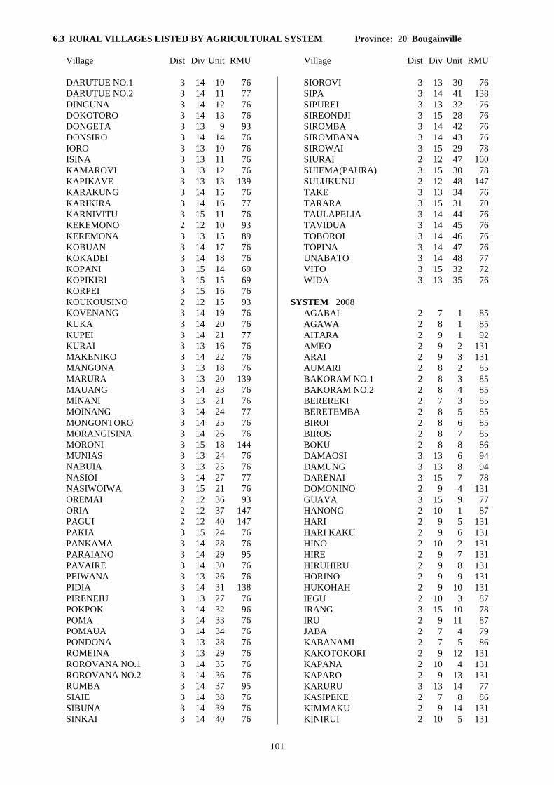
6.3 RURAL VILLAGES LISTED BY AGRICULTURAL SYSTEM Province: 20 Bougainville
Village Dist Div Unit RMU Village Dist Div Unit RMU
101
DARUTUE NO.1 3 14 10 76
DARUTUE NO.2 3 14 11 77
DINGUNA 3 14 12 76
DOKOTORO 3 14 13 76
DONGETA 3 13 9 93
DONSIRO 3 14 14 76
IORO 3 13 10 76
ISINA 3 13 11 76
KAMAROVI 3 13 12 76
KAPIKAVE 3 13 13 139
KARAKUNG 3 14 15 76
KARIKIRA 3 14 16 77
KARNIVITU 3 15 11 76
KEKEMONO 2 12 10 93
KEREMONA 3 13 15 89
KOBUAN 3 14 17 76
KOKADEI 3 14 18 76
KOPANI 3 15 14 69
KOPIKIRI 3 15 15 69
KORPEI 3 15 16 76
KOUKOUSINO 2 12 15 93
KOVENANG 3 14 19 76
KUKA 3 14 20 76
KUPEI 3 14 21 77
KURAI 3 13 16 76
MAKENIKO 3 14 22 76
MANGONA 3 13 18 76
MARURA 3 13 20 139
MAUANG 3 14 23 76
MINANI 3 13 21 76
MOINANG 3 14 24 77
MONGONTORO 3 14 25 76
MORANGISINA 3 14 26 76
MORONI 3 15 18 144
MUNIAS 3 13 24 76
NABUIA 3 13 25 76
NASIOI 3 14 27 77
NASIWOIWA 3 15 21 76
OREMAI 2 12 36 93
ORIA 2 12 37 147
PAGUI 2 12 40 147
PAKIA 3 15 24 76
PANKAMA 3 14 28 76
PARAIANO 3 14 29 95
PAVAIRE 3 14 30 76
PEIWANA 3 13 26 76
PIDIA 3 14 31 138
PIRENEIU 3 13 27 76
POKPOK 3 14 32 96
POMA 3 14 33 76
POMAUA 3 14 34 76
PONDONA 3 13 28 76
ROMEINA 3 13 29 76
ROROVANA NO.1 3 14 35 76
ROROVANA NO.2 3 14 36 76
RUMBA 3 14 37 95
SIAIE 3 14 38 76
SIBUNA 3 14 39 76
SINKAI 3 14 40 76
SIOROVI 3 13 30 76
SIPA 3 14 41 138
SIPUREI 3 13 32 76
SIREONDJI 3 15 28 76
SIROMBA 3 14 42 76
SIROMBANA 3 14 43 76
SIROWAI 3 15 29 78
SIURAI 2 12 47 100
SUIEMA(PAURA) 3 15 30 78
SULUKUNU 2 12 48 147
TAKE 3 13 34 76
TARARA 3 15 31 70
TAULAPELIA 3 14 44 76
TAVIDUA 3 14 45 76
TOBOROI 3 14 46 76
TOPINA 3 14 47 76
UNABATO 3 14 48 77
VITO 3 15 32 72
WIDA 3 13 35 76
SYSTEM 2008
AGABAI 2 7 1 85
AGAWA 2 8 1 85
AITARA 2 9 1 92
AMEO 2 9 2 131
ARAI 2 9 3 131
AUMARI 2 8 2 85
BAKORAM NO.1 2 8 3 85
BAKORAM NO.2 2 8 4 85
BEREREKI 2 7 3 85
BERETEMBA 2 8 5 85
BIROI 2 8 6 85
BIROS 2 8 7 85
BOKU 2 8 8 86
DAMAOSI 3 13 6 94
DAMUNG 3 13 8 94
DARENAI 3 15 7 78
DOMONINO 2 9 4 131
GUAVA 3 15 9 77
HANONG 2 10 1 87
HARI 2 9 5 131
HARI KAKU 2 9 6 131
HINO 2 10 2 131
HIRE 2 9 7 131
HIRUHIRU 2 9 8 131
HORINO 2 9 9 131
HUKOHAH 2 9 10 131
IEGU 2 10 3 87
IRANG 3 15 10 78
IRU 2 9 11 87
JABA 2 7 4 79
KABANAMI 2 7 5 86
KAKOTOKORI 2 9 12 131
KAPANA 2 10 4 131
KAPARO 2 9 13 131
KARURU 3 13 14 77
KASIPEKE 2 7 8 86
KIMMAKU 2 9 14 131
KINIRUI 2 10 5 131

6.3 RURAL VILLAGES LISTED BY AGRICULTURAL SYSTEM Province: 20 Bougainville
Village Dist Div Unit RMU Village Dist Div Unit RMU
102
KOKOMATE 3 15 12 78
KOKORE 3 15 13 77
KOKUI 2 10 6 131
KONAWA 2 8 9 85
KONGARA 2 8 10 85
KORO 2 7 12 78
KOROPO 2 9 15 131
KOTU 2 9 16 131
KUHINO 2 10 7 87
KUMUKI 2 9 17 131
KUNIKA 2 7 15 83
KUNU 2 10 8 131
KUPINKU 2 9 18 131
KUPON 2 7 16 83
KURITAVE 3 13 17 77
KUTIN 2 10 9 131
LABALAM 2 7 17 78
LABONAMI 2 7 18 78
LAKEMBA 2 9 19 131
LAKU 2 10 10 87
LARENAI 2 8 11 85
LAVORO 2 8 12 85
LOPERE 2 8 13 85
LORO 2 8 36 85
MABES 2 8 14 85
MAINOIATA 2 9 20 131
MAINOKI 3 15 17 78
MAISUA 2 10 11 87
MAMAGOTA 2 9 21 118
MANNAKE 2 9 43 131
MARIGA 2 8 15 85
MARILAU 3 13 19 90
MASIWAKORE 2 8 16 85
MASUNKE 2 8 17 82
MATERAS 2 10 12 87
MATONA 2 8 18 85
MATUKORI 2 9 22 131
MAWERE 2 8 19 85
MENDAI 2 8 20 85
MEWA 2 8 21 85
MEWARAKA 2 8 22 79
MIHERO 2 9 23 131
MINGETA 2 8 23 85
MOAINO 2 8 24 87
MOIBINEI 2 9 24 131
MOKOKOREU 2 7 22 85
MOKOLI NO.1 2 10 13 87
MOKOLI NO.2 2 10 14 87
MOMOGANARI 2 7 24 85
MORO 3 13 22 77
MOROKAIMORO 2 10 15 87
MORONEI 2 10 16 87
MOSIGETA 2 8 25 85
MOSINO 2 8 26 85
MUAU 3 13 23 94
MUMURAI 3 15 19 78
MUNU 2 10 17 131
MUSIMINOI 2 10 18 131
MUSINAU 3 15 20 145
MUWOKU 2 9 25 87
NAIRONA 2 8 27 85
NARINAI 2 7 25 85
NARONAI 2 10 19 87
NUKUI 2 8 28 85
NUKUI 2 9 26 131
OKARU 2 8 29 86
ONOVI 3 15 22 78
ORAMI 3 15 23 78
ORORO 2 8 30 85
OSIAGE 2 8 31 85
OSILADA 2 8 32 85
OSOKOLI 2 9 27 131
PANAKE 2 10 20 131
PANAM 2 7 26 86
PANKA 3 15 25 77
PERE 2 8 33 85
PIAWORA 3 15 26 78
PIKEI 2 8 34 85
PININAI 2 9 28 131
PISINAU 3 15 27 78
POLANAVIA 2 7 28 85
POMARATE 2 8 35 85
PURIKORI 2 9 29 131
RABAULU 2 9 30 131
RELA 2 7 29 78
ROKUSEI 2 10 21 131
ROMARI 2 8 37 85
ROTARE NO.1 2 8 38 85
ROTARE NO.2 2 8 39 86
RUPUMMO 2 9 44 131
RUSEI 2 10 22 131
RUUNAI 2 9 31 131
SIANEKI 2 7 30 85
SIKOREWA 2 7 31 78
SIKUMONE 2 10 23 87
SIKURAI 2 10 24 131
SININNAI 2 9 32 131
SINSIRUAI 2 8 40 85
SIPI 2 8 41 85
SIPURU 3 13 31 77
SIRARUHO 2 9 33 131
SIROI 2 9 34 131
SIROVAI 3 13 33 76
SIURUHINO 2 10 25 131
TAGURI 2 8 42 85
TAIDORIMA 2 8 43 85
TAKEMARI 2 8 44 85
TARAPA 2 11 34 131
TARUBA 2 7 32 85
TOHU 2 9 35 131
TOIRA 2 9 36 131
TOITOI 2 9 37 131
TOKUNUTU 2 9 38 131
TONNUI 2 9 39 131
TONU 2 9 40 131
TURUGUM 2 10 26 87
UNUNAI 2 9 41 131
USO 2 9 42 131

6.3 RURAL VILLAGES LISTED BY AGRICULTURAL SYSTEM Province: 20 Bougainville
Village Dist Div Unit RMU Village Dist Div Unit RMU
103
WAITAWUNA 2 8 45 85
WAKUPA 2 8 46 85
WARARIU 2 7 34 85
WARUWARU 2 7 35 85
WIWIARO 2 7 36 85
SYSTEM 2009
AKU 2 11 1 131
BOGISAGO 2 12 1 87
BORUPI 2 11 2 87
BURUBURUNNO 2 11 3 87
IAMARU 2 12 3 131
IBIRO 2 11 4 131
IPILAI 2 12 4 131
IULA NO.1 2 12 5 87
IULA NO.2 2 12 6 131
IULA NO.3 2 12 7 131
KAITU 2 12 8 87
KAMOURO 2 12 9 131
KANNAURO 2 11 5 131
KIKIBATSIOGU 2 12 11 131
KIKIMOGU 2 11 6 131
KOGISAGANO 2 11 7 87
KOGU 2 12 12 131
KOGUIKIRU 2 12 13 87
KOKOPO 2 11 8 131
KOMAI 2 12 14 131
KONIGURU 2 11 9 87
KUGUGAI 2 11 10 131
KUGUIOGU 2 12 16 131
KUKUMAI 2 12 17 131
KUKUMARU 2 11 11 131
KUMIROGU 2 11 12 87
LAGUAI 2 11 13 131
LAITARO 2 12 18 131
LAKOVE 2 12 19 131
LAMUAI 2 12 20 109
LEROTU 2 11 14 131
LOBIGOU 2 11 15 87
LUAGUO 2 12 21 131
LUILAU 2 12 22 131
LUKARARO 2 11 16 87
LUKAUKO 2 12 23 87
MAIKA 2 12 24 131
MALABITA 2 12 25 109
MAMAROMINO NO.1 2 12 26 131
MAMAROMINO NO.2 2 12 27 131
MARAMUKU 2 11 17 131
MATSIOUGU 2 11 18 87
MITUAI 2 12 28 131
MOGOROI 2 12 29 87
MORIU 2 12 30 87
MOROU 2 11 19 131
MORULA 2 11 20 87
MOUAKEI 2 11 21 131
MUGUAI 2 12 31 131
MUISURU 2 12 32 109
NABAKU 2 11 22 131
NAKARO 2 11 23 131
NAKOREI 2 11 24 131
NKUMU 2 12 33 109
NUMAKEI 2 11 25 87
OKOIRAGU 2 12 34 131
OKOMO 2 11 26 87
OMITARO 2 11 27 87
ORAVA 2 12 35 104
OREMUTSI 2 11 28 87
OROROI 2 12 38 87
ORUMOI 2 12 39 87
PARERO 2 12 41 87
PARERONO 2 11 29 87
PARIRO 2 12 42 87
PAULOUKU 2 12 43 87
PIARINO 2 11 30 131
PIRIRARO 2 12 44 87
PIRURUINO 2 11 31 87
SADI 2 12 45 104
SIALAU 2 11 32 87
SIUL 2 12 46 131
SIURU 2 11 33 87
TABAGO 2 12 49 131
TAGURUAI 2 12 50 131
TANTAREKI 2 12 51 131
TOGULEGU 2 11 35 87
TOKUAKA 2 11 36 111
TSIMBO 2 11 37 87
TUARAGAI 2 11 38 87
TUBARO 2 12 52 131
TUBARU 2 11 39 87
TUBOBISOU 2 11 40 87
TUGIOGU NO. 1 & 2 2 11 41 131
TUGIU 2 11 42 87
TURIGAU 2 11 43 87
TURUTAI 2 12 53 131
UBANMOIUTO 2 11 44 87
UGUPAKOGU 2 12 54 100

104

105
APPENDIX A.1
NATIONAL POPULATION CENSUS PROVINCIAL CODES
Province Abbreviation Code
Western WES 01 Gulf GUL 02 Central CEN 03 National Capital District NCD 04 Milne Bay MBP 05 Oro (Northern) ORO 06 Southern Highlands SHP 07 Enga ENG 08 Western Highlands WHP 09 Simbu (Chimbu) SIM 10 Eastern Highlands EHP 11 Morobe MOR 12 Madang MAD 13 East Sepik ESP 14 West Sepik (Sandaun) WSP 15 Manus MAN 16 New Ireland NIP 17 East New Britain ENB 18 West New Britain WNB 19 Bougainville NSP 20

AGRICULTURAL SYSTEMS OF PAPUA NEW GUINEA
Working Paper No. 20
BOUGAINVILLE PROVINCE
TEXT SUMMARIES, MAPS, CODE LISTS AND VILLAGE IDENTIFICATION
R.M. Bourke, M. Woruba, B.J. Allen, M. Allen, R. Grau and P. Hobsbawn
Department of Human Geography, The Australian National University, ACT 0200, Australia
REVISED and REPRINTED 2002

ii
Correct Citation: Bourke, R.M., Woruba, M., Allen, B.J., Allen, M., Grau, R. and Hobsbawn, P. (2002). Bougainville Province: Text Summaries, Maps, Code Lists and Village Identification. Agricultural Systems of Papua New Guinea Working Paper No. 20. Land Management Group, Department of Human Geography, Research School of Pacific and Asian Studies, The Australian National University, Canberra. Revised edition. National Library of Australia Cataloguing-in-Publication Entry: Bougainville Province: text summaries, maps, code lists and village identification. Rev. ed. ISBN 0 9579381 1 X 1. Agricultural systems – Papua New Guinea – Bougainville Province. 2. Agricultural geography – Papua New Guinea – Bougainville Province. 3. Agricultural mapping – Papua New Guinea – Bougainville Province. I. Bourke, R.M. (Richard Michael). II. Australian National University. Land Management Group. (Series: Agricultural systems of Papua New Guinea working paper; no. 20). 630.99592 Cover Photograph: The late Gore Gabriel clearing undergrowth from a pandanus nut grove in the Sinasina area, Simbu Province (R.L. Hide).

iii
PREFACE Acknowledgements The following organisations have contributed financial support to this project: The Research School of Pacific and Asian Studies, The Australian National University; The Australian Agency for International Development; the Papua New Guinea-Australia Colloquium through the International Development Program of Australian Universities and Colleges and the Papua New Guinea National Research Institute; the Papua New Guinea Department of Agriculture and Livestock; the University of Papua New Guinea; and the National Geographic Society, Washington DC. Technical advice and encouragement have been provided throughout the project by John McAlpine, Gael Keig and Sue Cuddy, Australian Commonwealth Scientific and Industrial Research Organization. Support and advice have been received from Geoff Humphreys and Harold Brookfield of the Land Management Project, and Gerard Ward (formerly Director), Research School of Pacific and Asian Studies, The Australian National University. Brookfield's (1971) study of Melanesian agricultural systems has been particularly influential. The Papua New Guinea Agricultural Systems Project was developed from two previous studies. Michael Bourke began mapping Papua New Guinea agricultural systems in the 1970s while a Senior Horticulturalist with the PNG Department of Primary Industry (Bourke 1976). Robin Hide created an annotated bibliography of information on Papua New Guinea agricultural systems while working with the CSIRO PNGRIS group (Hide and Cuddy 1988). Participants The following persons participated in the production of this paper: Papua New Guinea Department of Agriculture and Livestock: Moses Woruba, Bill Humphrey (field mapping) Papua New Guinea National Research Institute: Tony Regan (information on Care Centres) North Solomons Province Administration: John Siau (formerly Provincial Secretary) Australian National University: Bryant Allen, Michael Bourke (conceptualisation, field mapping, data preparation, writing); Robin Grau (GIS management, ARC/INFO, map preparation); Matthew Allen, Patricia Hobsbawn (literature review); Janine Conway (research assistance). Field survey and interviews Only a small part of the information reported here was gathered during fieldwork. Because of the Bougainville crisis, it was not possible to conduct fieldwork in central and southern Bougainville and no fieldwork was done as part of the Mapping Agricultural Systems of Papua New Guinea project by the ANU team. Instead, 23 persons were interviewed. Some preliminary mapping was done briefly in the Kieta, Wakunai, Togarau and Panguna areas in December 1980. In September 1992, Moses Woruba and Bill Humphrey of LAES Keravat spent three days surveying agriculture on Nissan and Pinipel Islands. Moses Woruba briefly visited the

iv
Nuguria group of coral atolls at this time. He also conducted extensive interviews with islanders from all atoll groups when a group were at Keravat on a training course. Information for Buka and Bougainville came mainly from interviews conducted with 23 persons between June and December 1996. The persons interviewed described agriculture in their home areas or places where they had worked. Several people provided information on more than one location. The interviews were conducted in the Kokopo, East New Britain area (13); Keravat, East New Britain, area (5); Port Moresby (3) and Canberra (2). Thirteen men and ten women were interviewed. Their most recent visit ranged from eight years to three weeks prior to the interview. Sixteen of the interviewees had either resided or had had extended visits to the province in the early-mid 1990s (1992-1996). The other seven had been home for only short term visits or had not lived in the province since 1988. The occupations of the persons interviewed were agriculturalist (5), teacher (5), administration/clerical (4), villager (3), housewife (2), Aid Post Orderly (1), medical doctor (1), policeman (1) and post-graduate student (1). Each interview took one to three hours. All were conducted separately, except for two persons from Siwai who were interviewed together and the three informants from the Kanua area. Thus the information presented here comes from separate interviews of two to four persons for each agricultural system, except for the Kanua area where all three informants were together. The quality of the information obtained was remarkably good, although not as useful as fieldwork. Information was surprisingly consistent for each location. Several aspects of the database are likely to be less reliable than if fieldwork has been conducted. These are: 1. System boundaries. The system boundaries tend to coincide with cultural or administrative ones.
Fieldwork may have suggested different boundaries. For example, fieldwork may have indicated that locations on Bougainville above 300 m altitude should be classed as a single agricultural system with longer fallow periods, shorter cropping periods, taro an important crop and sweet potato not planted in mounds.
2. Fallow periods. These were determined from informants’ descriptions of fallow vegetation as well as the stated periods, as the latter are often underestimated in reality in Papua New Guinea.
3. Cropping periods. Information from informants was reasonably consistent, but not as accurate as would have been gained from numerous garden visits.
Nine agricultural systems have been identified for the province. Agriculture on Nissan and Pinipel Islands (System 2001), the smaller atolls (System 2002) and the small islands off the west coast of Buka Island (2004) is quite distinctive for each system. However, the systems for Buka Island (System 2003), the Tinputz-Wakunai area (System 2005), northwest Bougainville (System 2006) and southwest Bougainville (System 2008) are very similar. Only minor differences in sub-dominant staples, the number of plantings before fallow and cash cropping separate these four systems. Given the source of information, the differences may not be real (except for cash cropping where information appears reliable and consistent). The system in southeast Bougainville (System 2007) and south Bougainville (Buin area, System 2009) are similar to each other, but differ from the other four systems on Buka-Bougainville in that only one planting is made before land is fallowed in southeast and south Bougainville. The civil war (known as the Bougainville crisis in PNG) has caused considerable disruption to the villagers in parts of the province, especially in central, south and southwest Bougainville. In early 1997, PNG government sources indicate that some 45,000 people in Bougainville Province were

v
living in Care Centres. The largest concentration was in the Buin area where about 17,000 people were still in Care Centres. During the worst years of the crisis, in the early-mid 1990s, the PNG government was providing rice to many villagers in Care Centres throughout the province. The supply of rice was reported to be irregular and people still depended on food gardens to a greater or lesser degree. Most people who were still in Care Centres were growing most of their own food in their own gardens. However, some people were still mainly dependent on rice supplied by the government in early 1997. These people were located mainly in the Buin area (about 13,000 people) and in the Arawa area (about 4000 people). Much material relevant to agricultural development is summarised in the North Solomons Provincial Development Study, particularly Section A of Volume 2 (Economic Consultants 1982). While the information on cash supply is now dated, it still provides a useful overview for the province. Persons interviewed The following were interviewed at Kokopo, Keravat, Port Moresby and Canberra: Evelyn Boxall, Katherine Billy, Ben Hulo, Cyril Imako, Mary Jal, Lugakei Joe, Linda Kamang, Louise Kurika, Michael Lugabai, Eris Memora, Ambrose Mopei, Murray Nahiana, Rachael Rake, Sam Rangai, Salome Silovo, Jerry Sipana, Joyce Sipana, Ruth Spriggs, Samual Tapets, Heather Timate, Daniel Tokapip, Thomasina Umue and Moses Woruba. Their assistance is greatly appreciated. Revised and reprinted version The Mapping Agricultural Systems Project database was revised in late 1998 (see Introduction to Working Paper Number 1). This working paper was reprinted in 2002. Karen Lummis, Tess McCarthy, Natalie Stuckings, Laura Vallee, Amber Pares and Veerle Vlassak were responsible for the production of the revised paper.

vi

vii
CONTENTS
Preface iii
1. Introduction 1
2. Database Structure, Definitions and Codes 5
3. Agricultural Systems: Text Summaries 17
System 2001 19 System 2002 21 System 2003 25 System 2004 29 System 2005 31 System 2006 35 System 2007 39 System 2008 43 System 2009 49
4. Agricultural Systems: Maps 53
5. Agricultural Systems: Data Listing by Codes 73
6. Listings of Rural Villages (Census Units) Indexed to Agricultural Systems 85
6.1 Rural Villages with Agricultural System numbers in census order 87 6.2 Rural Villages with Agricultural System numbers in alphabetical order 93 6.3 Rural Villages listed by Agricultural System (with PNGRIS RMU numbers) 99
Appendix A.1 National Population Census Provincial Codes 105
Appendix A.2 National Population Census Codes for Districts and Census Divisions, Bougainville Province 106

viii

1
1. INTRODUCTION
The major purpose of the Papua New Guinea Agricultural Systems Project is to produce information
on small holder (subsistence) agriculture at provincial and national levels. Information is collected
by field observation, interviews with villagers and reference to published and unpublished
documents. The information is entered into a computer database (dBase IV), from where it is
transferred to a mapping program (ARC/INFO). Methods are described by Bourke et al. (1993).
This paper contains a written summary of the information on the Agricultural Systems in this
Province, maps of selected agricultural features, a complete listing of all information in the database
in coded form, and lists of villages with National Population Census codes, indexed by Agricultural
Systems. This information will eventually be available on disk as a map-linked database suitable
for use on a personal computer.
Identification of agricultural systems and subsystems
An Agricultural System is identified when a set of similar agricultural crops and practices occur
within a defined area. Six criteria are used to distinguish one system from another:
1. Fallow type (the vegetation which is cleared from a garden site before cultivation).
2. Fallow period (the length of time a garden site is left unused between cultivations).
3. Cultivation intensity (the number of consecutive crops planted before fallow).
4. The staple, or most important, crops.
5. Garden and crop segregation (the extent to which crops are planted in separate gardens; in
separate areas within a garden; or are planted sequentially).
6. Soil fertility maintenance techniques (other than natural regrowth fallows).
Where one or more of these factors differs significantly and the differences can be mapped, then a
separate system is distinguished.
Where variation occurs, but is not able to be mapped at 1:500 000 scale because the areas in which
the variation occurs are too small or are widely dispersed within the larger system, a subsystem is
identified. Subsystems within an Agricultural System are allocated a separate record in the
database, identified by the Agricultural System number and a subsystem number.
Sago is a widespread staple food in lowland Papua New Guinea. Sago is produced from palms
which are not grown in gardens. Most of the criteria above cannot be applied. In this case, systems
are differentiated on the basis of the staple crops only.
2
Relationship to PNGRIS
The Papua New Guinea Resource Information System (PNGRIS) contains information on the
natural resources of PNG (Bellamy 1986). However PNGRIS contains no information on
agricultural practices, other than an assessment of land use intensity based on air photograph
interpretation by Saunders (1993), and ECOPHYS which is concerned with predicted crop
performance in a specific environment (Hackett 1988). The Agricultural Systems Project is
designed to provide detailed information on agricultural practices and cropping patterns as part of an
upgraded PNGRIS geographical information system. For this reason the Agricultural Systems
database contains almost no information on the environmental settings of the systems, except for
altitude and slope. The layout of the text descriptions, the database code files and the village lists
are modelled on PNGRIS formats (Cuddy 1987).
The mapping of Agricultural Systems has been carried out on the same map base and scale as
PNGRIS (Tactical Pilotage Charts, 1:500 000). It is also done within the areas of agricultural land
use established by Saunders (1993) from aerial photography. Except where specifically noted,
Agricultural Systems boundaries have been mapped without reference to PNGRIS Resource
Mapping Unit (RMU) boundaries. Agricultural Systems are defined at the level of the Province
(following PNGRIS) but their wider distribution is recognised in the database by cross-referencing
systems which cross provincial borders.
A preliminary view of the relationships between RMUs and the Agricultural Systems in this
Province can be obtained from the listing of villages by Agricultural System, where RMU numbers
are appended (Section 6.3).
Note for reprinted edition
Most of the fieldwork for this project was conducted over a six year period (late 1990 to late 1996).
Over this period, a number of minor inconsistencies arose in data classification and presentation.
As well, some changes occurred in conventions for the text fields and in the definitions of data
fields, for example, for seasonality, fencing and burning. These changes were noted in the Preface
of the Provincial Working Papers (first editions) as they occurred. One of the more important
changes was that the cutoff points for the classification of cash earning activities were applied more
consistently. Because of these inconsistencies and changes in definitions, it was necessary to revise
the database so that it was consistent for all 19 provinces and to incorporate changes in agriculture
systems since the original papers were produced.
Most changes, as distinct from definitional changes, relate to cash income. The revisions were done
in late 1998. The largest number of changes occurred in the first four provincial working papers:
East Sepik, West Sepik, Western and Gulf Provinces. Papers for the five Island Region provinces
required the least number of changes. Agricultural systems that cross provincial boundaries have
been adjusted so that the information is identical on both sides of the boundary, apart from some
minor differences in some of the text fields. However the notes have not been updated to
incorporate new publications since the Working Papers were completed.

3
References Bellamy, J. (ed) 1986 Papua New Guinea Inventory of Natural Resources, Population Distribution and Land Use Handbook. CSIRO Division of Water and Land Resources, Natural Resources Series No. 6, Canberra. Bourke, R.M. 1976 Food crop farming systems used on the Gazelle Peninsula of New Britain. In K. Willson and R.M. Bourke (eds) Proceedings of the 1975 Papua New Guinea Food Crops Conference, Department of Primary Industry, Port Moresby, 81-100. Bourke, R.M., R.L. Hide, B.J. Allen, R. Grau, G.S. Humphreys and H.C. Brookfield 1993 Mapping agricultural systems in Papua New Guinea. In T. Taufa and C. Bass (eds) Population, Family Health and Development. Volume 1 of Papers from the 19th Waigani Seminar, Port Moresby, 16-22 June 1991. University of Papua New Guinea Press, Port Moresby, 205-224. Brookfield, H.C. with D. Hart 1971 Melanesia: a Geographical Interpretation of an Island World. Methuen, London. Cuddy, S.M. 1987 Papua New Guinea Inventory of Natural Resources, Population Distribution and Land Use: Code Files Parts I-VII. CSIRO Division of Water and Land Resources, Canberra. Economic Consultants 1982 North Solomons Provincial Development Study. Final Report. Economic Consultants Limited in assocation with Shankland Cox Partnership, Booker Agriculture International Limited and Sea Fish Industry Authority. Hackett, C. 1988 Matching Plants and Land: Development of a General Broadscale System from a Crop Project for Papua New Guinea. CSIRO Division of Water and Land Resources, Natural Resources Series No. 11, Canberra. Hide, R.L. and S.M. Cuddy 1988 Papua New Guinea Inventory of Natural Resources, Population Distribution and Land Use: Annotated and Selected Bibliography of Smallholder Farming Systems in PNG: Part I New Guinea Mainland, New Guinea Islands. CSIRO Division of Water and Land Resources, Canberra. National Nutrition Survey 1982/3. Provincial Tabulations. Papua New Guinea Institution of Medical Research and Nutrition Section, National Department of Health, Goroka. Ruthenberg, H. 1980 Farming Systems in the Tropics. Oxford University Press, London. Saunders, J.C. 1993 Agricultural Land Use of Papua New Guinea [map with explanatory notes]. Scale 1:1 000 000. PNGRIS Publication No. 1. CSIRO, Brisbane.
Smith, T., G. Keig, J. Marks and R. Grau 1992 Summary Results by Environmental Zone from the
1982-3 National Nutrition Survey of Papua New Guinea: Implications for Future Survey Design.
Papua New Guinea Institute of Medical Research, Goroka.

4

5
2. DATABASE STRUCTURE, DEFINITIONS AND CODES
Information on agricultural systems is stored in a database, one record per agricultural system (or
subsystem where identified) and 108 fields per record. This section lists the field names and their
database abbreviations [NAMES]. Summary descriptions, explanatory notes and variable codes are
given for each field.
LOCATION AND IDENTIFICATION
1. Provincial Identification [PROVINCE]: A two digit National Population Census code. Eg. code
14 = East Sepik Province. Provincial codes are listed in Appendix A.1.
2. System Identification [SYSTIDNO]: A two digit number identifying the agricultural system within
this province. Eg. code 01 = System 01. Numbers are not assigned to systems within a province in
any particular order.
3. Agricultural System [AGSYST]: Systems are also identified by a unique Papua New Guinea-wide
four digit number. The first two digits are the National Population Census provincial code and the
second two digits are the system identification number. Eg. 1401 = System 01 in the East Sepik
Province.
4. Agricultural Subsystem [SUSBSYSIDNO]: Subsystems are identified by a single digit. When
referred to in the text they are preceded by the agricultural system number and a hyphen. Eg. 1418-1
is Subsystem 1 of System 1418.
5. Number of Subsystems [NUMSUBSYS]: A single digit specifying the number of subsystems that
occur within this System.
6. District [DISTRICT]: The 1990 National Population Census code for the District within which the
System is located. More than one District may be listed. District codes are listed in Appendix A.2.
7. Census Divisions [CENSUSDIV]: The 1980 National Population Census code for the Census
Divisions that occur within the System. Census Division codes for this Province are listed in
Appendix A.2.
ENVIRONMENTAL
8. Lowest Altitude [ALTLOW]: The lowest altitude, in metres (rounded), to which the System
extends.
9. Highest Altitude [ALTHIGH]: The highest altitude, in metres (rounded), to which the System
extends.
10. Garden Slope [SLOPE]: The average slope of gardens in the System.
1 Flat (<2o)
2 Gentle (2-10o)
3 Steep (10-25o)
4 Very steep (>25o)
5 Multiple classes

6
11. Survey Description [SURVDESC]: A text description of the areas visited or not visited within the
system, the length of time spent in different areas, traverses undertaken, the mode of transport used,
the month and year of the survey, and the sources of any documentary information used.
12. Summary Description [SYSSUMM]: A concise text description of the agricultural system, and
subsystems (if any), focussed on the occurrence of the major distinguishing criteria.
13. System Boundary Definitions [BOUNDDEF]: A brief description of how the boundaries between
systems were identified and mapped. The boundaries between agricultural and non-agricultural land
use were taken from Saunders (1993).
14. Systems Crossing Provincial Borders [OTHPROV]: A logical field (yes/no) which indicates
whether the System crosses a provincial border.
15. Same System in Adjacent Province [PROVSYS]: A listing of AGSYST numbers (see Field 3
above) of up to two systems in adjacent provinces which are identical to this system, for systems
which cross provincial borders.
16. Subsystem Extent [SUBSYSEXT]: An estimate of the proportion of the area of the total system
occupied by a subsystem. In the case of there being no subsystems this field is listed as 100 per
cent.
1 25 per cent
2 50 per cent
3 75 per cent
4 100 per cent
17. Type of Fallow Vegetation Cleared [FALLTYPE]: The predominant type of vegetation cleared
from garden sites at the beginning of a new period of cultivation. Where short fallows are used (see
Field 18 below), fallow type refers to the vegetation cleared after a long fallow.
1 Short grass (eg. kunai < 1.5 m tall)
2 Tall grass (eg. Miscanthus or Saccharum > 1.5 m tall)
3 Grass and woody regrowth (dense short or tall grass and short woody
regrowth)
4 Short woody regrowth (shrubs/trees < 10 m tall)
5 Tall woody regrowth (trees > 10 m tall)
6 Forest (no indication of previous use)
7 No long fallow
8 Savanna (Scattered woody growth with grass ground cover)
18. Use of Short Fallows [SHORTFALL]: A presence and significance measure which indicates
whether short fallows are used. Short fallows are brief periods of less than 12 months between
plantings during which land is left fallow.
19. The Long Fallow Period [FALLPER]: An estimate of the length of time (greater than 12 months)
land is left to revert to regrowth, before it is cultivated again. Class 0 refers to situations where very
long cropping intervals (40 plantings or more) make long fallows not significant.
0 Not significant
1 1 to 4 years
2 5 to 15 years
3 Greater than 15 years

7
20. Cropping Intensity [CROPINT]: The number of times staple crops are planted in the main
gardens before those gardens are returned to a long fallow. Short fallows of less than 12 months (see
Field 18 above) are excluded for this purpose: they may occur between plantings without affecting
the classification. The class 'More than 40 plantings', refers to situations where land has been
planted continuously without a long fallow since the Pacific War (1942-45) or longer. In such cases
Field 19, Long Fallow Period, is classed as 'Long fallow period not significant'.
1 1 planting only
2 2 plantings
3 3 to 5 plantings
4 6 to 14 plantings
5 15 to 40 plantings
6 More than 40 plantings
CROP COMPONENTS
21. The Dominant Staple Crops [DOMSTAP]: The most important staple food crops grown in the
subsystem. A major staple is defined as a crop estimated to cover more than one-third of staple
garden area, and therefore no more than 3 dominant staples may be identified for a system. An
important exception occurs when sago is the staple. Sago is extracted from palms which are not
cultivated in gardens. In the text accounts (System Summaries and Notes), dominant staples are
described as the 'most important crops'.
22. The Subdominant Staple Crops [SUBSTAP]: Staple food crops of lesser importance grown in the
subsystem. A subdominant staple is defined as a crop estimated to cover more than 10 per cent of a
staple garden area; up to six crops may be listed. An important exception occurs when sago is the
staple. Sago is extracted from palms which are not cultivated in gardens. In the text accounts
(System Summaries and Notes), subdominant staples are described as 'important crops'.
23. All Staple Crops [ALLSTAP]: A list of up to 10 staple crops including crops classed as dominant
and subdominant, as well as other staple crops which occur commonly. In the text accounts (System
Summaries and Notes), staple crops which are classified as neither dominant nor subdominant are
described as 'other crops'.
01 Mixed staple (no dominant staple: a mix of some or all of: banana, taro, sweet potato
Chinese taro, yam, cassava and corn)
02 Banana (Musa cvs) 13 Taro (Colocasia esculenta)
03 Breadfruit (Artocarpus altilis) 14 Yam (Dioscorea alata)
04 Cassava (Manihot esculenta) 15 Yam (Dioscorea esculenta)
05 Chinese taro (Xanthosoma sagittifolium) 16 Yam (Dioscorea pentaphylla)
06 Coconut (Cocos nucifera) 17 Other
07 Corn (Zea mays) 18 Queensland arrowroot (Canna
08 Potato (Solanum tuberosum) edulis)
09 Sago (Metroxylon sagu) 19 Taro (Amorphophallus)
10 Swamp taro (Cyrtosperma (Amorphophallus paeoniifolius)
chamissonis) 20 Yam (Dioscorea bulbifera)
11 Sweet potato (Ipomoea batatas) 21 Yam (Dioscorea nummularia)
12 Taro (Alocasia macrorrhiza)
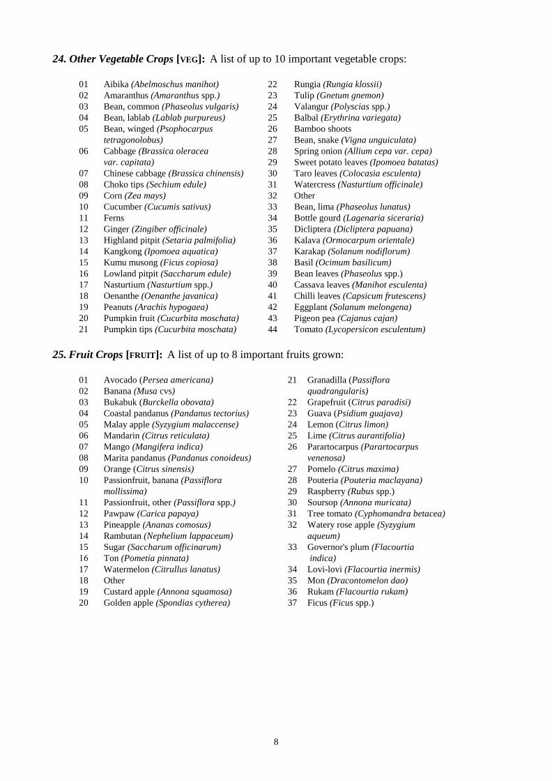
8
24. Other Vegetable Crops [VEG]: A list of up to 10 important vegetable crops:
01 Aibika (Abelmoschus manihot) 22 Rungia (Rungia klossii)
02 Amaranthus (Amaranthus spp.) 23 Tulip (Gnetum gnemon)
03 Bean, common (Phaseolus vulgaris) 24 Valangur (Polyscias spp.)
04 Bean, lablab (Lablab purpureus) 25 Balbal (Erythrina variegata)
05 Bean, winged (Psophocarpus 26 Bamboo shoots
tetragonolobus) 27 Bean, snake (Vigna unguiculata)
06 Cabbage (Brassica oleracea 28 Spring onion (Allium cepa var. cepa)
var. capitata) 29 Sweet potato leaves (Ipomoea batatas)
07 Chinese cabbage (Brassica chinensis) 30 Taro leaves (Colocasia esculenta)
08 Choko tips (Sechium edule) 31 Watercress (Nasturtium officinale)
09 Corn (Zea mays) 32 Other
10 Cucumber (Cucumis sativus) 33 Bean, lima (Phaseolus lunatus)
11 Ferns 34 Bottle gourd (Lagenaria siceraria)
12 Ginger (Zingiber officinale) 35 Dicliptera (Dicliptera papuana)
13 Highland pitpit (Setaria palmifolia) 36 Kalava (Ormocarpum orientale)
14 Kangkong (Ipomoea aquatica) 37 Karakap (Solanum nodiflorum)
15 Kumu musong (Ficus copiosa) 38 Basil (Ocimum basilicum)
16 Lowland pitpit (Saccharum edule) 39 Bean leaves (Phaseolus spp.)
17 Nasturtium (Nasturtium spp.) 40 Cassava leaves (Manihot esculenta)
18 Oenanthe (Oenanthe javanica) 41 Chilli leaves (Capsicum frutescens)
19 Peanuts (Arachis hypogaea) 42 Eggplant (Solanum melongena)
20 Pumpkin fruit (Cucurbita moschata) 43 Pigeon pea (Cajanus cajan)
21 Pumpkin tips (Cucurbita moschata) 44 Tomato (Lycopersicon esculentum)
25. Fruit Crops [FRUIT]: A list of up to 8 important fruits grown:
01 Avocado (Persea americana) 21 Granadilla (Passiflora
02 Banana (Musa cvs) quadrangularis)
03 Bukabuk (Burckella obovata) 22 Grapefruit (Citrus paradisi)
04 Coastal pandanus (Pandanus tectorius) 23 Guava (Psidium guajava)
05 Malay apple (Syzygium malaccense) 24 Lemon (Citrus limon)
06 Mandarin (Citrus reticulata) 25 Lime (Citrus aurantifolia)
07 Mango (Mangifera indica) 26 Parartocarpus (Parartocarpus
08 Marita pandanus (Pandanus conoideus) venenosa)
09 Orange (Citrus sinensis) 27 Pomelo (Citrus maxima)
10 Passionfruit, banana (Passiflora 28 Pouteria (Pouteria maclayana)
mollissima) 29 Raspberry (Rubus spp.)
11 Passionfruit, other (Passiflora spp.) 30 Soursop (Annona muricata)
12 Pawpaw (Carica papaya) 31 Tree tomato (Cyphomandra betacea)
13 Pineapple (Ananas comosus) 32 Watery rose apple (Syzygium
14 Rambutan (Nephelium lappaceum) aqueum)
15 Sugar (Saccharum officinarum) 33 Governor's plum (Flacourtia
16 Ton (Pometia pinnata) indica)
17 Watermelon (Citrullus lanatus) 34 Lovi-lovi (Flacourtia inermis)
18 Other 35 Mon (Dracontomelon dao)
19 Custard apple (Annona squamosa) 36 Rukam (Flacourtia rukam)
20 Golden apple (Spondias cytherea) 37 Ficus (Ficus spp.)

9
26. Nut Crops [NUT]: A list of up to 5 important nuts grown or collected:
01 Breadfruit (Artocarpus altilis) 09 Karuka, wild (Pandanus brosimos)
02 Candle nut (Aleurites moluccana) 10 Okari (T. kaernbachii/ T. impediens)
03 Castanopsis (Castanopsis 11 Sis (Pangium edule)
acuminatissima) 12 Pao (Barringtonia spp.)
04 Coconut (Cocos nucifera) 13 Tulip (Gnetum gnemon)
05 Finschia (Finschia chloroxantha) 14 Other
06 Galip (Canarium indicum) 15 Polynesian chestnut (Inocarpus
07 Java almond (Terminalia catappa) fagifer)
08 Karuka, planted (Pandanus 16 Cycad (Cycas spp.)
julianettii) 17 Entada (Entada scandens)
18 Dausia (Terminalia megalocarpa)
27. Narcotic Crops [NARC]: A list of up to 5 important narcotics grown:
1 Betel nut, highland (Areca macrocalyx)
2 Betel nut, lowland (Areca catechu)
3 Betel pepper, highland (Piper gibbilimbum)
4 Betel pepper, lowland (Piper betle)
5 Tobacco (Nicotiana tabacum)
6 Kava (Piper methysticum)
FORMS OF GARDEN AND CROP SEGREGATION
28. Garden Segregation [GARDSEG]: A presence and significance measure of whether individual
staple food crops are planted in different gardens. A garden is a contiguous area of land planted
with crops under the management of a social unit such as a family or a household. If some gardens
are sited in different vegetation zones, and have different fallow periods, cultivation periods or other
agronomic characteristics, then they are assigned to a separate subsystem.
All presence and significance measures are coded as follows:
0 None
1 Minor or insignificant
2 Significant
3 Very significant
29. Crop Segregation [CROPSEG]: A presence and significance measure of whether individual
staple food crops are planted separately in different parts of the same garden.
30. Crop Sequences [CROPSEQU]: A presence and significance measure of whether the harvesting
of one crop species is usually followed by the planting of another, eg. yams followed by sweet
potato, or sweet potato followed by peanuts followed by sweet potato (see also Field 33 below).
31. Mixed Vegetable Gardens [MIXGARD]: A presence and significance measure of whether mixed
gardens are used. A mixed garden is typically a garden which is subsidiary to that containing the
main staple(s). It is planted with a wide range of either subdominant staples and/or other vegetables.
It may or may not be distinguished from the main garden types by different fallow and agronomic
techniques.
32. Household Gardens [HOUSGARD]: A presence and significance measure of whether house
gardens are used. A house garden is typically a garden that is small relative to the main gardens, is
located near houses, and which contains a variety of crops. Also known as door yard or kitchen
gardens.
10
SOIL FERTILITY MAINTENANCE TECHNIQUES
33. Legume Rotation [LEGUMROT]: A presence and significance measure of whether a leguminous
crop (eg. peanuts or winged bean) is grown between plantings of main food crops.
34. Planted Tree Fallow [TREEFALL]: A presence and significance measure of whether tree species
(eg. Casuarina oligodon or Parasponia spp.) are planted into gardens or fallows for the stated
purpose of improving soil quality during subsequent cultivations. This measure excludes the
practice of planting fruit tree species into gardens and fallows, but does not exclude the planted trees
being used for timber or firewood.
35. The Use of Compost [COMPOST]: A presence and significance measure of whether organic
matter is placed beneath the surface of the soil.
36. The Use of Animal Manure [MANURE]: A presence and significance measure of whether
animal manure is placed on or in the soil. The measure does not include the deposition of manure by
the animals themselves, eg. pigs tethered in gardens.
37. The Use of Island Beds: [ISLBED]: A presence and significance measure of whether island beds
are used. Island beds are beds of soil on which crops are planted and which are raised above the
level of a surrounding area of standing or slowly moving water.
38. The Contribution of Silt from Flooding [SILT]: A presence and significance measure of
whether silt from floods is deposited either regularly or sporadically on the soil surface in gardens.
It is assumed the flooding is of natural causes, but the measure does not exclude deliberate
manipulation of stream channels in order to enhance the delivery of silt or for the partial control of
flood waters.
39. The Use of Inorganic Fertiliser [FERT]: A presence and significance measure of whether
inorganic fertiliser is applied to gardens. This measure excludes the use of inorganic fertiliser on
cash crops, such as coffee or vegetables.
OTHER AGRICULTURAL PRACTICES
40. The Placing of Pigs in Gardens [PIGSIN]: A presence and significance measure of whether pigs
are placed in gardens between plantings. Pigs may be placed in gardens between plantings for a
number of stated reasons, eg. to eat earthworms, to eat unharvested crops, or to till the soil. This
measure excludes the deliberate breaking of fences to allow pigs to forage after the cropping phase.
41. Burning [BURN]: A presence and significance measure of whether fallow vegetation cleared and
cut in a new garden site is burnt before the planting of the staple crops. The measure includes the
burning of material which has been heaped. Significance takes into account the frequency of burning
relative to the cropping intensity. So, for example, if the majority of the fallow material cleared from
the site is burnt at the initial clearing of a garden, and only one or two plantings are made before
fallowing, burning is Very Significant. If the same thing occurs at clearing, but a large number of
plantings are made before the next long fallow, with little or no burning between plantings, burning
is Minor.

11
42. Soil Tillage [TILL]: A presence and significance measure of whether soil in the staple food
gardens is tilled before planting. Tillage includes the breaking up, or turning over, of the whole or
the major part of the soil on the garden surface. The measure includes tillage in either the first
planting and/or subsequent plantings. The formation of soil mounds and beds (see Fields 53-58
below) involves working the soil into a tilth, but in order to distinguish clearly between these
processes, mounds and beds are not automatically classified as soil tillage.
43. The Use of Deep Holing [HOLE]: A presence and significance measure of whether deep holing
is used. Deep holing is sometimes used in yam cultivation in order to influence the dimensions and
shape of the tubers. Deep (> 50 cm) holes are dug, the soil is broken into a fine tilth and the hole re-
filled before planting. The use of this technique is usually restricted to the cultivation of Dioscorea
alata.
44. Cutting Fallow Vegetation Onto the Crops [FALLCUT]: A presence and significance measure of
whether crops are planted beneath standing fallow vegetation, and the vegetation is later cut down
onto the growing crops.
45. The Use of Fences [FENCE]: A presence and significance measure of whether gardens are
fenced. Fences are linear barriers made of wood, bamboo, cane grass or stones, and may incorporate
a ditch or a bank. The measure excludes low ridges which form between fields when stones are
thrown to the perimeter during cultivation. In the assessment of the significance of fences, the
occurrence of fences around every individual garden is given greater significance than one fence
around a large number of gardens.
46. The Use of Irrigation [IRRIG]: A presence and significance measure of whether water is applied
to crops by the use of channels or aqueducts.
47. The Use of Mulch [MULCH]: A presence and significance measure of whether a mulch is used
to cultivate the staple crops. A mulch is organic material which is applied to the soil surface. If the
material is placed beneath the soil surface it is defined as a compost (see Field 35 above).
48. The Seasonality of Main Crops [SEASMAJ]: A presence and significance measure of whether
the dominant staples (most important food crops) and the subdominant staples (important food
crops) are planted at about the same time each year.
49. The Seasonality of Other Crops [SEASMIN]: A presence and significance measure of whether
other staple crops and vegetable crops are planted at about the same time each year.
50. The Use of Drains [DRAIN]: A presence and significance measure of whether ditches are used in
and around gardens to remove surface water or to lower the groundwater table.
51. The Use of Soil Retention Barriers [SOILRET]: A presence and significance measure of whether
structures (pegged logs, fences or hurdles, stone walls) are constructed along the contour or below
individual plants, in order to prevent or reduce the down slope movement of soil.
52. The Use of Staking [STAKE]: A presence and significance measure of whether crops are trained
or tied up stakes, trellises or standing dead trees to lift them off the soil surface. The practice is
usually applied to yams (Dioscorea spp.), beans, sugarcane, and sometimes gourds, cucumber and
choko.

12
MOUNDING TECHNIQUES
In many parts of Papua New Guinea the soil is formed into circular mounds of varying dimensions
and crops are planted on them. Mounding should not be confused with composting (see Field 35
above). Mounds may or may not contain compost and composting may take place in the absence of
mounds. Mounds are usually re-formed at each new planting. Mound formation usually involves
extensive soil disturbance. The effect can be similar to complete soil tillage (see Field 42 above).
The following fields contain presence and significance measures of whether mounds of the specified
dimensions are used in the system.
53. Very Small Mounds [VSMMOUND]: Mounds up to 10 cm high.
54. Small Mounds [SMMOUND]: Mounds 10 to 40 cm high.
55. Medium Sized Mounds [MOUND]: Mounds 40-70 cm high and between 1 m and 2.5 m in
diameter.
56. Large Mounds [LRGEMOUND]: Mounds > 70 cm high and > 2.5 m in diameter.
GARDEN BED TECHNIQUES
In some locations the soil is also raised into beds and crops planted on them. Bed formation usually
involves extensive soil disturbance. The effect can be similar to complete soil tillage (see Field 42
above). Two shapes of beds are distinguishable:
57. Square Beds [BEDSQ]: Square beds are constructed by digging shallow ditches typically 2 to 4
metres apart on a grid layout, and throwing the soil removed onto the surface to form a bed. The
outcome is a characteristic chequerboard or gridiron pattern in gardens.
58. Long Beds [BEDLONG]: Long beds are constructed by digging shallow ditches down slope
typically 2 to 4 metres apart and over 10 metres in length, and throwing the soil removed to the
centre to form a bed.
59. Mechanical Soil Tillage [MECHAN]: The use of tractors or hand-held cultivators in the
preparation of a garden site for food crops. The measure includes the use of machinery in the
cultivation of crops for sale.
CASH EARNING ACTIVITIES
A presence and significance measure of the importance of the following common rural cash income
sources. The list includes sources related to agricultural or land based production from the farmers'
own resources.
60. Animal Products [ANSKIN]: The sale of animal skins, furs and bird plumes, but not fresh meat.
61. Betel Nut [BETEL]: The sale of betel nuts (Areca catechu or A. macrocalyx) and associated
items like pepper and lime.
62. Cardamom [CARDAM]: The sale of cardamom (Elettaria cardamomum).
63. Cattle [CATTLE]: The sale of cattle as live beasts or as fresh meat.

13
64. Chillies [CHILLIE]: The sale of dried chillies (Capsicum frutescens).
65. Cocoa [COCOA]: The sale of cocoa (Theobroma cacao) beans.
66. Copra [CNUT]: The sale of copra and nuts from coconut palms (Cocos nucifera).
67. Arabica Coffee [COFFARAB]: The sale of Arabica coffee (Coffea arabica).
68. Robusta Coffee [COFFROB]: The sale of Robusta coffee (Coffea canephora).
69. Crocodile Products [CROC]: The sale of freshwater and saltwater crocodile (Crocodylus spp.)
skins or meat, from managed and wild animals.
70. Firewood [FIREWOOD]: The sale of firewood.
71. Fish [FISH]: The sale of fresh or smoked freshwater or saltwater fish, shellfish or crustacea.
72. Fresh Food: [FOOD]: The sale of fresh vegetables, fruits, nuts and fresh or smoked meat from
domesticated or wild animals.
73. Oil Palm [OILPALM]: The sale of palm oil fruit (Elaeis guineensis).
74. Potato [POTATO]: The sale of Irish potatoes (Solanum tuberosum).
75. Pyrethrum [PYRETH]: The sale of dried pyrethrum flowers (Chrysanthemum cinerariaefolium).
76. Rice [RICE]: The sale of rice (Oryza sativa).
77. Rubber [RUBB]: The sale of latex from rubber trees (Hevea brasiliensis).
78. Sheep and Wool [SHEEP]: The sale of sheep as live animals, or meat and the sale of wool.
79. Tea [TEA]: The sale of unprocessed tea (Camellia sinensis).
80. Tobacco [TOBACCO]: The sale of the dried tobacco leaf (Nicotiana tabacum).
81-82. Other [OTHER1] [OTHER2]: Other unlisted sources of cash include the sale of copal gum
(Agathis sp.), massoi bark (Massoia aromatica), tigasso oil (Campnosperma sp.), salt extracted
from plants or natural springs and deposits, mineral oil, bêche-de-mer, insects and butterflies, live
birds, marsupials, pigs and horses, house building materials including thatching and sheets of woven
cane, canoe hulls, clothing, weapons, string bags, carvings and artefacts. This category excludes
other sources of cash income such as wages and salaries, logging or mining royalties, gold mining,
banditry, gambling and remittances. These are mentioned in Notes (Field 83) if they are important.
83. Further Notes [NOTES]: Additional notes on particularly outstanding features of the system and
further information drawn from published and unpublished documents.

14
SURVEY DETAILS
Fields 84-101 contain details of dates when observations were made of the system for the purposes
of this project and the names of the persons who made the observations. Up to three survey visits
can be accommodated. The field names are:
Month of a short visit [SVDATMON]: Eg. 01 = January.
Year of a short visit [SVDATYR]: Eg. 1992.
Period of a longer term study [SVPERYRA]: Eg. 1971-72.
Person making the visit [SURVNAME]: Initials of person(s). Full names are given in a Key on the
relevant page in Section 5.
The type of survey [SURVTYPE]
1 Very brief visit to one place (less than an hour), or interviews
2 Short visit to a few places ( less than 1 day)
3 Visits to several places (1 to 3 days)
4 Multiple visits to many places (4 to 15 days)
5 Multiple visits to many locations over several years ( more than 15 days)
102. Information From the National Nutrition Survey 1982-83 [NNS]: The National Nutrition
Survey 1982/83, selected families in villages across most of the country from a sampling frame
based on environments drawn from PNGRIS classifications. Amongst other questions, people were
asked what foods they had eaten during the previous day (NNS 1982/3). For systems in which more
than 10 families were interviewed, responses for particular foods are presented as percentages of the
total number of families interviewed. Results are presented only for staple foods, fresh fish and
purchased rice. The entry includes the number of families and number of villages surveyed, and the
month and year of survey.
This information is more than 10 years old and is independent of the information collected by the
Agricultural Systems Project. It should be used carefully (Smith et al. 1992). In some Systems the
sample size is small and villages sampled may be restricted to one part of the System. It is possible
that Chinese taro (Xanthosoma sagittifolium) has been included in the general term 'taro', increasing
the importance of taro (Colocasia esculenta) and decreasing the importance of Chinese taro. Where
diets change seasonally, the results may also be unrepresentative.
103. Main References [REF]: References to published and unpublished documents that contain
substantial information on agriculture in the System.
104. Other References [REF2]: References to published and unpublished documents that contain
additional information directly relevant to the Agricultural System.
105. The Area of the System [AREA]: The area, in square kilometres, occupied by the System. The
figure is calculated by the mapping program ARC/INFO.
106. Total Resident Population 1980 [TOTPOP]: The total population resident within the area
covered by the System at the time of the 1980 National Population Census. The 1990 National
Population Census figures are not used because of questions over their reliability, but the 1990
National Population Census maps are used to locate most Census Units.

15
107. The Number of People Living Outside the System [ABSPOPPER]: An estimate of the
proportion of the population absent from villages in the system in 1978-79, expressed as a
percentage of the total population. The figure is the difference between the 'total' population and the
'resident' population listed in the 1978-79 Provincial Data System (PDS) Rural Community Register
for the Province. The 'total' population is the total number of persons listed in the Village Book and
the 'resident' population the number living in the village, or who have been absent for less than 6
months at the time of the census. In some cases 'total' and 'resident' populations in the PDS are the
same.
108. The Population Density [POPDEN]: The number of persons per square kilometre in 1980,
calculated by dividing Field 106 (total population) by Field 105 (area). There are two situations
where adjusted figures are given (indicated by "*"). In some systems sago is the staple food and
there is little or no agriculture or subsistence is based completely on non-agricultural activities (eg.
fishing or trading) and no agricultural land use can be identified. For these systems the area has
been adjusted to include a 5 kilometre buffer strip around the system boundary, or centred on
settlements where no land use is identified. The 5 kilometre buffer zone is assumed to be the area of
non-agricultural land, usually forest, in which wild plants and animals are exploited. In the latter
case, settlements are identified with point symbols. The second kind of adjustment occurs where the
populations of two adjoining systems, both of which use both systems, are unequally distributed in
the two system areas due to the locations of the census units. In such cases, adjusted population
density figures are shown (for example, Milne Bay Province Systems 0501 and 0502), with
explanations in Notes (Field 83).
109. The Intensity of Land Use [RVALUE]: The R value (Ruthenberg 1980, 15) is an estimate of the
intensity of land use, derived from the ratio of the Cropping Period in years to the length of the
cultivation cycle in years. Cropping Period is estimated from the number of plantings of the staple
crops before a long fallow (see Field 20 above). The cultivation cycle is the sum of the Cropping
Period and the Long Fallow Period (see Field 19 above). The R value is thus:
Cropping Period x 100
Cropping Period + Long Fallow Period
Because in this survey both the cropping period and the long fallow period are described as classes,
conversion of the class ranges to single year values is necessary in order to calculate R values. The
following conversions are used for most crops:
Cropping period Years Long fallow period Years
1 planting only 1 Not used 0
2 plantings 2 1-4 years 3
3-5 plantings 4 5-15 years 10
6-14 plantings 10 >15 years 20
>14 plantings 20
Triploid banana or Chinese taro may produce for several years from a single planting. In systems in
which these crops are dominant staples or subdominant staples with significant land use, the
cropping period is adjusted upwards. The adjustment is based on estimates of how long these crops
produce from a single planting before a long fallow. Where there is evidence of a cropping period
without a long fallow of longer than 20 years, the cropping period is adjusted upwards, to a
maximum of 50 years.

16

17
3. AGRICULTURAL SYSTEMS: TEXT SUMMARIES
Text summaries take two forms: those for the first or only subsystem in an Agricultural System, and
those for subsequent subsystems.
1. The headers on text summaries for the first or only subsystem in an Agricultural System are as
follows:
PROVINCE 15 West Sepik AGRICULTURAL SYSTEM No. 1 Subsystem No 1 of 1
Districts 4 Telefomin Subsystem Extent 100% Area (sq km) 1259
Population 8,530 Population Density 7 persons/sq km Population absent 7%
This header contains information in the top right hand corner on the number of subsystems
descriptions which follow.
This header also contains information for the whole Agricultural System on Districts, area,
population, population density and absenteeism.
2. Headers on text summaries of subsequent subsystems are as follows:
PROVINCE 15 West Sepik AGRICULTURAL SYSTEM No. 3 Subsystem No 2 of 2
Districts 4 Telefomin Subsystem Extent 25 %
They contain information on Districts and subsystem extent only.
Headers on second and subsequent pages of summaries are as follows:
PROVINCE 15 West Sepik AGRICULTURAL SYSTEM No. 1 Subsystem No 1 of 1

BOUGAINVILLE PROVINCE Agricultural systems
Nissan Is Nuguria Is
Ins et 1
Buka I
•' .2 • 2
•'u •'
""
c::::J No agriculture !::::::::::) Ag ricultur a I system
identified by number
Bo uga in ville I
Kilometers
~
~ ~ Tulun Is ..
'2
Locality map
••
Takuu Is
Inset 2
~.
··""-·
Nukumanu Is
Inset 3
Map ping Agricultural Systems Project, Hum an Geo gr ap hy,
ANU; PNG DAL; Geography, UPNG, 1999
3

19
System Summary Located on Nissan and Pinipel Islands (Green Islands). The fallow vegetation is short woody regrowth, three years or younger for sweet potato and cassava gardens and a little older for other crops. Fallow vegetation is cut, dried and burnt. Sweet potato is the most important crop; taro, banana and coconut are important crops; other crops are Chinese taro, cassava, yam (D. alata and D. esculenta) and Alocasia taro. Mangrove seeds are an important food on Pinipel Island. Sweet potato is planted in separate gardens or sometimes in a separate section of a garden. Yams, interplanted with taro, are planted in separate sections. Usually only one planting is made before fallowing, but a second planting of sweet potato may be made. Household gardens are common.
Extends across provincial border to System(s) None
Altitude range (m) 0-20 Slope Gentle (2-10 degrees)
CROPS STAPLES DOMINANT Sweet potato STAPLES SUBDOMINANT Banana, Coconut, Taro (Colocasia) STAPLES PRESENT Banana, Cassava, Chinese taro, Coconut, Sweet potato, Taro (Alocasia), Taro
(Colocasia), Yam (D. alata), Yam (D. esculenta) OTHER VEGETABLES Aibika, Chinese cabbage, Corn, Kumu musong, Pumpkin tips, Valangur, Bean
(snake) FRUITS Bukabuk, Coastal pandanus, Mango, Pawpaw, Sugarcane, Ton, Guava, Mon NUTS Breadfruit, Galip, Java almond, Pao, Polynesian chestnut NARCOTICS Betel nut (lowland), Betel pepper (lowland), Tobacco FALLOW & CROPPING PERIOD FALLOW TYPE Short woody regrowth SHORT FALLOW None LONG FALLOW PERIOD 1-4 years CROPPING PERIOD 1 planting R VALUE 25 (low)
GARDEN SEGREGATION GARDEN SEGREGATION Significant CROP SEGREGATION Minor CROP SEQUENCES None MIXED VEGETABLE GARDENS None HOUSEHOLD GARDENS Significant
SOIL FERTILITY MAINTENANCE LEGUME ROTATION None PLANTED TREE FALLOW None COMPOST None ANIMAL MANURE None ISLAND BED None SILT FROM FLOOD None INORGANIC FERTILISER None
CASH EARNING ACTIVITIES 1 Fish Significant 2 Coconuts Minor
OTHER AGRONOMIC PRACTICES Water Management: DRAINAGE None IRRIGATION None Soil Management: PIGS PLACED IN GARDENS None BURN FALLOW VEGETATION Significant TILLAGE None MECHANIZATION None DEEP HOLING None MULCHING None SOIL RETENTION BARRIERS None Mounding Techniques: VERY SMALL MOUNDS Significant SMALL MOUNDS None MOUNDS None LARGE MOUNDS None Garden Bed Techniques: BEDS SQUARE None BEDS LONG None Other Features: FENCES Very significant STAKING OF CROPS Minor FALLOW CUT ONTO CROPS None SEASONAL MAIN CROPS Minor SEASONAL SEC'DARY CROPS Minor
PROVINCE 20 Bougainville AGRICULTURAL SYSTEM No. 1 Subsystem No. 1 of 1 Districts 1 Buka Subsystem Extent 100 % Area (sq km) 38 Population 2,991 Population density 79 persons/sq km Population absent 13 %

20
OTHER DOCUMENTATION Survey description In September 1992, agricultural systems on Nissan and Pinipel Islands were surveyed (3 days). Boundary definition Nissan and Pinipel Islands were allocated to a separate system after visits to these islands and to other atolls. Notes This system is distinguished from the atoll system (System 2002) where continuous cultivation of coconut, swamp taro and sweet potato is the main agricultural activity. Land is very limited on Pinipel Island and each family has only small gardens. Family plots are typically 5-10 m wide. Woruba and Humphrey (1993) noted that sweet potato growth appeared to be poor on Pinipel. In contrast, gardens on Nissan Island appeared to produce well and land availability was not a serious problem. Soils are shallow and overlie limestone, and hence food production is vulnerable to drought. Woruba and Humphrey (1993) reported that the farming systems on both atolls were characterised by the use of stone piles in the gardens which seperated pockets of deeper soil for planting. After the fallow period, vegetation was cut and removed from the site for burning. However there were some important differences between the farming systems of the two islands. On Nissan Island sweet potato was grown with other crops, on a mixed cropping basis, whilst on Pinipel crops were grown in separate sections of the garden. On Pinipel two consecutive sweet potato plantings were made before the garden was left to fallow, and whilst the first crop was usually successful, the second was unreliable. Gardeners on Pinipel felt that the current varieties of sweet potato were inferior to those used in the past. On Pinipel, stone fences are extensively used for keeping pigs out of gardens. The food crops grown also varied somewhat between the two atolls. Cassava, banana, aibika, sweet potato and taro were grown on both atolls, but corn, yam (both D. alata and D. esculenta), snake bean and pawpaw were grown only on Nissan. Moreover, on Pinipel, fruit trees, including breadfruit and mangroves, were planted near the gardens. Mangroves (Burguiera eriopetala) were eaten daily on Pinipel and were a major staple, together with sweet potato and banana. There are three stages of preparation of mangrove fruit prior to consumption. Fruit and nut trees are very important on both atolls, particularly galip and pao nuts. Some sago (M. salomense) is eaten. Golden apple is another fruit that is eaten. Yams are planted seasonally in July-August. Taro is planted between yam plants some months later at the beginning of the wet season. Sweet potato and vegetables tend to be planted at the start of the wetter months (October-December). Yams are grown on stakes. Sweet potato and yams are planted in very small mounds. Archaeological evidence from Nissan indicates that humans have been exploiting coconuts and galip nuts since the Takaroi phase (c. 4850 BP) (Spriggs 1991, 230). These nuts were found to still be important on Nissan (note that pao nut had also become important). However, on Pinipel, coconut trees were in short supply due to space limitations (Woruba and Humphrey 1993). Sale of fish and copra are the main income sources. Other income comes from the sale of betel nut, cocoa and fresh food. National Nutrition Survey 1982/83 In this province, the survey was conducted during 1980 and no dietary recall information was collected. Main References Woruba, M. and W. Humphrey 1993 A survey report of cropping practices on atolls in Papua New Guinea. Sustainable Agriculture Series Workshop Paper 1/93, Lowlands Agricultural Experiment Station, Department of Agriculture and Livestock, Keravat. Other References Spriggs, M. 1991 Nissan, the island in the middle. Summary report on excavations at the north end of the Solomons and the south end of the Bismarcks. In Allen, J. and C. Gosden (eds), Report of the Lapita Homeland Project. Canberra, Department of Prehistory, Research School of Pacific Studies, Australian National University, 222-243.
PROVINCE 20 Bougainville AGRICULTURAL SYSTEM No. 1 Subsystem No. 1 of 1

21
System Summary Located on the Tulun (Carteret), Takuu (Mortlock), Nukumanu (Tasman) and Nuguria (Fead) atolls. Food sources are purchased food, coconut, swamp taro, fish, fruit, nuts and some garden food. The most important garden food is swamp taro; sweet potato and cassava are important garden foods; other crops include banana, taro, Chinese taro and Alocasia taro. Cultivation of coconuts, swamp taro and banana is permanent. Sweet potato tends to be planted continuously. Other crops follow short woody regrowth fallows, and 2-3 plantings are made before land is fallowed for short periods. Occasionally, a cassava planting follows sweet potato. Swamp taro is planted in separate plots where soil fertility is maintained by mulching with coconut fronds. Within gardens, sweet potato and cassava are planted in separate sections. Sweet potato is planted in mounds about 20 cm high. Household gardens are common.
Extends across provincial border to System(s) None
Altitude range (m) 0-3 Slope Flat (<2 degrees)
CROPS STAPLES DOMINANT Coconut, Swamp taro STAPLES SUBDOMINANT Cassava, Sweet potato STAPLES PRESENT Banana, Cassava, Chinese taro, Coconut, Swamp taro, Sweet potato, Taro
(Alocasia), Taro (Colocasia) OTHER VEGETABLES Aibika, Pumpkin tips, Valangur, Bean (snake), Taro leaves, Other FRUITS Bukabuk, Coastal pandanus, Malay apple, Pawpaw, Sugarcane NUTS Breadfruit, Java almond, Pao, Polynesian chestnut NARCOTICS None FALLOW & CROPPING PERIOD FALLOW TYPE No long fallow SHORT FALLOW Minor LONG FALLOW PERIOD Not significant CROPPING PERIOD >40 plantings R VALUE 100 (high)
GARDEN SEGREGATION GARDEN SEGREGATION Very significant CROP SEGREGATION Minor CROP SEQUENCES Minor MIXED VEGETABLE GARDENS None HOUSEHOLD GARDENS Significant
SOIL FERTILITY MAINTENANCE LEGUME ROTATION None PLANTED TREE FALLOW None COMPOST None ANIMAL MANURE None ISLAND BED None SILT FROM FLOOD None INORGANIC FERTILISER None
CASH EARNING ACTIVITIES 1 Coconuts Minor 2 Fish Minor
OTHER AGRONOMIC PRACTICES Water Management: DRAINAGE None IRRIGATION None Soil Management: PIGS PLACED IN GARDENS None BURN FALLOW VEGETATION Minor TILLAGE None MECHANIZATION None DEEP HOLING None MULCHING Significant SOIL RETENTION BARRIERS None Mounding Techniques: VERY SMALL MOUNDS None SMALL MOUNDS Significant MOUNDS None LARGE MOUNDS None Garden Bed Techniques: BEDS SQUARE None BEDS LONG None Other Features: FENCES None STAKING OF CROPS None FALLOW CUT ONTO CROPS None SEASONAL MAIN CROPS None SEASONAL SEC'DARY CROPS None
PROVINCE 20 Bougainville AGRICULTURAL SYSTEM No. 2 Subsystem No. 1 of 1 Districts 1 Buka Subsystem Extent 100 % Area (sq km) 16 Population 1,607 Population density 100 persons/sq km Population absent 26 %
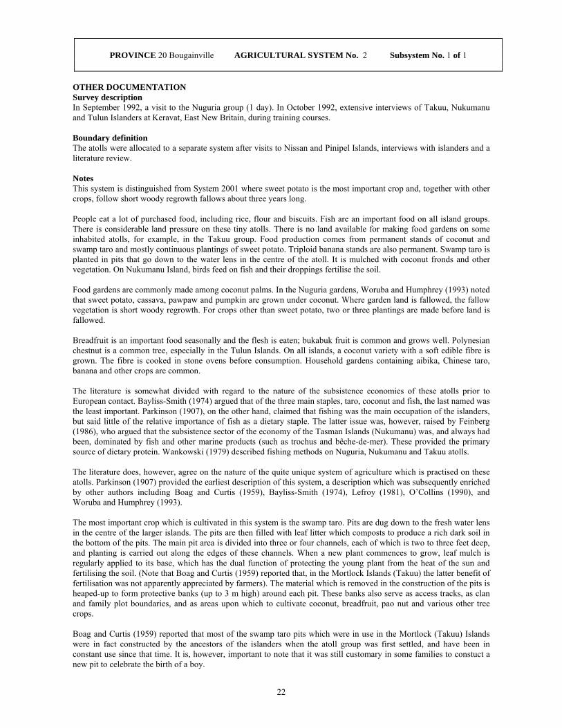
22
OTHER DOCUMENTATION Survey description In September 1992, a visit to the Nuguria group (1 day). In October 1992, extensive interviews of Takuu, Nukumanu and Tulun Islanders at Keravat, East New Britain, during training courses. Boundary definition The atolls were allocated to a separate system after visits to Nissan and Pinipel Islands, interviews with islanders and a literature review. Notes This system is distinguished from System 2001 where sweet potato is the most important crop and, together with other crops, follow short woody regrowth fallows about three years long. People eat a lot of purchased food, including rice, flour and biscuits. Fish are an important food on all island groups. There is considerable land pressure on these tiny atolls. There is no land available for making food gardens on some inhabited atolls, for example, in the Takuu group. Food production comes from permanent stands of coconut and swamp taro and mostly continuous plantings of sweet potato. Triploid banana stands are also permanent. Swamp taro is planted in pits that go down to the water lens in the centre of the atoll. It is mulched with coconut fronds and other vegetation. On Nukumanu Island, birds feed on fish and their droppings fertilise the soil. Food gardens are commonly made among coconut palms. In the Nuguria gardens, Woruba and Humphrey (1993) noted that sweet potato, cassava, pawpaw and pumpkin are grown under coconut. Where garden land is fallowed, the fallow vegetation is short woody regrowth. For crops other than sweet potato, two or three plantings are made before land is fallowed. Breadfruit is an important food seasonally and the flesh is eaten; bukabuk fruit is common and grows well. Polynesian chestnut is a common tree, especially in the Tulun Islands. On all islands, a coconut variety with a soft edible fibre is grown. The fibre is cooked in stone ovens before consumption. Household gardens containing aibika, Chinese taro, banana and other crops are common. The literature is somewhat divided with regard to the nature of the subsistence economies of these atolls prior to European contact. Bayliss-Smith (1974) argued that of the three main staples, taro, coconut and fish, the last named was the least important. Parkinson (1907), on the other hand, claimed that fishing was the main occupation of the islanders, but said little of the relative importance of fish as a dietary staple. The latter issue was, however, raised by Feinberg (1986), who argued that the subsistence sector of the economy of the Tasman Islands (Nukumanu) was, and always had been, dominated by fish and other marine products (such as trochus and bêche-de-mer). These provided the primary source of dietary protein. Wankowski (1979) described fishing methods on Nuguria, Nukumanu and Takuu atolls. The literature does, however, agree on the nature of the quite unique system of agriculture which is practised on these atolls. Parkinson (1907) provided the earliest description of this system, a description which was subsequently enriched by other authors including Boag and Curtis (1959), Bayliss-Smith (1974), Lefroy (1981), O’Collins (1990), and Woruba and Humphrey (1993). The most important crop which is cultivated in this system is the swamp taro. Pits are dug down to the fresh water lens in the centre of the larger islands. The pits are then filled with leaf litter which composts to produce a rich dark soil in the bottom of the pits. The main pit area is divided into three or four channels, each of which is two to three feet deep, and planting is carried out along the edges of these channels. When a new plant commences to grow, leaf mulch is regularly applied to its base, which has the dual function of protecting the young plant from the heat of the sun and fertilising the soil. (Note that Boag and Curtis (1959) reported that, in the Mortlock Islands (Takuu) the latter benefit of fertilisation was not apparently appreciated by farmers). The material which is removed in the construction of the pits is heaped-up to form protective banks (up to 3 m high) around each pit. These banks also serve as access tracks, as clan and family plot boundaries, and as areas upon which to cultivate coconut, breadfruit, pao nut and various other tree crops. Boag and Curtis (1959) reported that most of the swamp taro pits which were in use in the Mortlock (Takuu) Islands were in fact constructed by the ancestors of the islanders when the atoll group was first settled, and have been in constant use since that time. It is, however, important to note that it was still customary in some families to constuct a new pit to celebrate the birth of a boy.
PROVINCE 20 Bougainville AGRICULTURAL SYSTEM No. 2 Subsystem No. 1 of 1

23
PROVINCE 20 Bougainville AGRICULTURAL SYSTEM No. 2 Subsystem No. 1 of 1
Notes continued Feinberg (1986, 273) reported that, in the Tasman (Nakumanu) Islands, the islanders claimed that Colocasia taro ‘used to grow’ on their atoll, but has all died. Colocasia taro is, however, regarded as an important secondary crop in the Mortlock (Takuu) Islands where five varieties are cultivated (Lefroy 1981, 11). In the late 1950s, the Mortlock islanders came to the realisation that Colocasia taro is better suited to dry conditions (until then it had been grown in the swamp taro pits, with unsatisfactory results) and commenced cultivating Colocasia taro on the raised intervals between the swamp taro pits and channels (Boag and Curtis 1959, 24). They also observed that the islanders had commenced cultivating Colocasia taro in the dry soils of the coconut fringe. It is important to note that coconut is widely regarded as the most plentiful and important species on all the atolls (Lefroy 1981, 10; Feinberg 1986, 272). Coconuts are used as a source of food, fuel, constructon material, and perhaps most importantly, dietary liquid. Coconut was originally introduced to the islands in ancient times (Lefroy 1981, 10). However it seems that the German colonial administration was instrumental in encouraging the planting of coconut, resulting in the high concentrations of coconut trees which now characterise the islands (Boag and Curtis 1959, 25; Feinberg 1986, 274). Thus, the literature indicates that the most important subsistence staples are coconut, swamp taro and fish (and other marine products). Other crops of minor importance include: breadfruit, pao nut, banana, pandanus, sugarcane, giant (Alocasia) taro, pawpaw, pumpkin, cassava, Polynesian arrowroot, bukabuk [misidentified by Lefroy as Pouteria], Chinese taro, Amorphophallus taro, sago, mango, guava, oranges, valangur, golden apple, watery rose apple and Java almond (Terminalia). Yam (D. esculenta) was found to be an important standby crop in the Mortlock and Carteret Islands (Boag and Curtis 1959, 24; Lefroy 1981, 12). Moreover, kangkong (Ipomoea aquatica) which is ideally suited to the swamp taro pits, Polynesian chestnut and sago palm are minor crops in the Carteret Islands; and sweet potato, purslane, mangrove and Malay apple are minor crops in the Nuguria (Fead) Islands (Lefroy 1981, 12-13). With the developement of income generating activities and modern trade, imported food products are becoming increasingly important. Lefroy (1981, 10) pointed out that more rice was being eaten on some of the atolls. Indeed, in the Nukumanu (Tasman) Islands, Feinberg (1986, 275-6) claimed that, next to coconut, the atoll’s major staples had become wheat flour and rice. He also reported that cash generating activities in the Tasman Islands were, in descending order of importance: collecting and preparing bêche-de-mer; trochus shell; and copra production (Feinberg 1986, 276). O’Collins (1990, 250) observed that in the Carteret Islands cash income levels were extremely unreliable and inconsistent due to the fact that sales of copra, shells, bêche-de-mer and other fish products depended on regular sea transport to Kieta on Bougainville Island. The case of the Tulun (Carteret) Islands is particularly significant because the resources of the island have been widely regarded as being over-exploited (Kukang et al. 1987; O’Collins 1990). Indeed, the island has periodically experienced food shortages of varying severity since the 1960s. As a consequence an 'Atolls Resettlement Scheme' has been in operation since late 1984, and has seen the resettlement of Tulun Islanders in an area of Bougainville known as Kuveria, which is 30 km from Arawa, along the Kieta-Buka Highway (Kukang et al. 1987; O’Collins 1990). All of the settlers reportedly had left the scheme in the late 1980s, prior to the Bougainville crisis. Some copra is made in Tulun, Nukumanu and Nugaria groups. Small quantities of smoked fish are sold at Buka, Kokopo and Honiara markets. Other minor cash income sources include sale of bêche-de-mer and trochus shell. National Nutrition Survey 1982/83 In this province, the survey was conducted during 1980 and no dietary recall information was collected. Main References Boag, A.D. and R.E. Curtis 1959 Agriculture and population in the Mortlock Islands. Papua and New Guinea Agricultural Journal 12, 1, 20-27. Lefroy, E. 1981 Growing food on coral atolls. Harvest 7, 1, 7-13. Other References Bayliss-Smith, T. 1974 Constraints on population growth: the case of the Polynesian outlier atolls in the precontact period. Human Ecology 2, 4, 259-295. Feinberg, R. 1986 Market economy and changing sex roles on a Polynesian atoll. Ethnology 25, 271-282. Kukang, T., E. Tade, J. Selwyn, A. Siau and M. Wairiu 1987 The Atolls Resettlement Scheme: Kuveria, North Solomons Province. In O'Collins, M. (ed), Rapid Rural Appraisal: Case Studies of Small Farming Systems. Port Moresby, Department of Anthropology and Sociology, University of Papua New Guinea, 65-92.

24
PROVINCE 20 Bougainville AGRICULTURAL SYSTEM No. 2 Subsystem No. 1 of 1
Other References continued O'Collins, M. 1990 Carteret islanders at the Atolls Resettlement Scheme: a response to land loss and population growth. In Pernetta, J.C. and P.J. Hughes (eds), Implications of expected climate changes in the South Pacific region: an overview. UNEP Regional Seas Reports and Studies No. 128. Nairobi, United Nations Environment Program, 247-269. Parkinson, R. 1907 Dreissig Jahre in der Südsee. Land und Leute, Sitten und Gebräuche im Bismarckarchipel und auf den Deutschen Salomoinseln. (Thirty Years in the South Seas. The Bismarck Archipelago: Land, Natives and Customs - English translation by N.C. Barry). Stuttgart, Berlag von Strecker and Schröder. Wankowski, J.W.J. 1979 Subsistence fishing methods on Nuguria, Nukumanu and Takuu atolls. Harvest 5, 3, 179-185. Woruba, M. and W. Humphrey 1993 A survey report of cropping practices on atolls in Papua New Guinea. Sustainable Agriculture Series Workshop Paper 1/93, Lowlands Agricultural Experiment Station, Department of Agriculture and Livestock, Keravat.

25
System Summary Located on Buka Island and the northern tip of Bougainville Island. Fallow vegetation is tall woody regrowth, typically 5-6 years old, with a range of 2-10 years. Fallow vegetation is cut, dried and burnt. Sweet potato is the most important crop; banana, taro and coconut are important crops; other crops are cassava and Chinese taro. Sweet potato and taro are grown in separate gardens. Banana, cassava and Chinese taro are planted on the edge of gardens. Generally, two or three plantings are made before fallowing, but up to five plantings may be made. Sweet potato is planted in mounds about 30 cm high.
Extends across provincial border to System(s) None
Altitude range (m) 0-80 Slope Flat (<2 degrees)
CROPS STAPLES DOMINANT Sweet potato STAPLES SUBDOMINANT Banana, Coconut, Taro (Colocasia) STAPLES PRESENT Banana, Cassava, Chinese taro, Coconut, Sweet potato, Taro (Colocasia) OTHER VEGETABLES Aibika, Choko tips, Corn, Ferns, Kumu musong, Lowland pitpit, Pumpkin tips,
Tulip, Bean (snake), Other FRUITS Bukabuk, Malay apple, Mango, Pawpaw, Sugarcane, Watermelon, Guava NUTS Breadfruit, Galip, Pao NARCOTICS Betel nut (lowland), Betel pepper (lowland), Tobacco FALLOW & CROPPING PERIOD FALLOW TYPE Tall woody regrowth SHORT FALLOW None LONG FALLOW PERIOD 5-15 years CROPPING PERIOD 3-5 plantings R VALUE 29 (low)
GARDEN SEGREGATION GARDEN SEGREGATION Significant CROP SEGREGATION Minor CROP SEQUENCES None MIXED VEGETABLE GARDENS None HOUSEHOLD GARDENS None
SOIL FERTILITY MAINTENANCE LEGUME ROTATION None PLANTED TREE FALLOW None COMPOST None ANIMAL MANURE None ISLAND BED None SILT FROM FLOOD None INORGANIC FERTILISER None
CASH EARNING ACTIVITIES 1 Coconuts Very significant 2 Cocoa Significant 3 Fresh food Significant 4 Betel nut Minor
OTHER AGRONOMIC PRACTICES Water Management: DRAINAGE None IRRIGATION None Soil Management: PIGS PLACED IN GARDENS None BURN FALLOW VEGETATION Very significant TILLAGE None MECHANIZATION None DEEP HOLING None MULCHING None SOIL RETENTION BARRIERS None Mounding Techniques: VERY SMALL MOUNDS None SMALL MOUNDS Very significant MOUNDS None LARGE MOUNDS None Garden Bed Techniques: BEDS SQUARE None BEDS LONG None Other Features: FENCES Minor STAKING OF CROPS None FALLOW CUT ONTO CROPS None SEASONAL MAIN CROPS None SEASONAL SEC'DARY CROPS None
PROVINCE 20 Bougainville AGRICULTURAL SYSTEM No. 3 Subsystem No. 1 of 1 Districts 1 Buka Subsystem Extent 100 % Area (sq km) 678 Population 17,739 Population density 26 persons/sq km Population absent 18 %

26
OTHER DOCUMENTATION Survey description In June and October 1996, interviews with five people from north, east and south Buka Island. No field visits were made.
Boundary definition Buka Island was allocated to a separate system after interviewing five people from Buka Island; two people from small islands west of Buka (System 2004); and field visits and interviews with people from the atolls (Systems 2001 and 2002). The boundaries with Systems 2005 and 2006 between Baniu and Soraken Harbour on northern Bougainville are based on the extent of the flat raised coral reefs. This estimate is confirmed by interviews with people from Buka and the Tinputz area.
Notes This system is distinguished from Nissan and Pinipel atolls (System 2001) where fallows are short woody regrowth fallows about three years old. It is distinguished from the small atolls (System 2002) where coconut, swamp taro, fish, fruit, nuts and some sweet potato and cassava are the main foods. It is distinguished from System 2004 on the small islands west of Buka where land use is more intensive with fallow periods of only about one year. This system is almost identical to System 2005 to the south on Bougainville, but garden segregation is less important there and there is a weak tendency for more plantings to be made before land is fallowed in that system. The system is also very similar to System 2006 on the west coast of Bougainville, but in that system cassava is somewhat more important and taro less important than in this system.
Fallow vegetation is mostly tall woody regrowth, but some short woody regrowth is used where land pressure is most intensive on the east coast. Fallow periods on the east coast are estimated at about 5-6 years, but two of the five informants indicated that fallow periods were only 2-4 years. Two or three plantings are usually made before fallowing, with a range of 1-5 plantings.
Significant quantities of imported rice are eaten. Some fish is eaten in coastal villages. In south Buka, villagers obtain a lot of seafood, such as mud crabs and shell fish, from mangrove stands. The pith of a self-sown plant that is similar to a banana, but with thin stems, is commonly eaten as a vegetable. It is known as 'tsip' in south Buka. The mangos eaten come from wild trees, not the cultivated species. Nuts of Pangium edule ('sel') are eaten in inland Buka. Tobacco is more common in inland and north Buka. Some peanuts are grown in inland Buka.
An archaeological survey (Wickler 1990, 140) found evidence suggesting that Colocasia taro had been used in this region in the Pliestocene and Holocene eras. Evidence was also discovered suggesting the use of Canarium spp., particularly C. indicum and C. solomonese, from about 9000 BP.
Blackwood (1935, 271-312) conducted field work in the north of Bougainville in the late 1920s and observed that taro was the most important staple crop. Many different varieties of taro were known; one woman identified twelve varieties in her garden, and claimed that there were many more. Coconut was also identified as an important staple, and it was certainly the most important of the nut species.
Blackwood provided an exhaustive list of the other vegetables, nuts and fruits which were eaten, including: sweet potato, yam, breadfruit, pumpkin, squash, sugarcane, several varieties of mushrooms, leaves of taro and other plants, coconut, galip, Java almond, pao, banana, wild passion fruit, mango, pawpaw, orange and lime. In addition to these foodstuffs, various animals were hunted including wild pig, opossum, flying fox, bats, birds, lizards, frogs and insects. Taro was frequently traded for fish. Breadfruit was identified as particularly important when in season, during which time people reduced their consumption of taro. Moreover, people indicated that sago was eaten in times of scarcity, when the taro crop had failed. Importantly, Blackwood noted that, compared to other parts of Bougainville, sweet potato and yam were relatively unimportant in this region.
According to Blackwood, taro was predominantly cultivated on its own, although pumpkins, bananas, and other fruit and nut trees were sometimes planted in taro gardens. Taro was cultivated using a form of shifting agriculture. Plots of bush were cleared and burnt, and taro ‘stalks’ were planted in holes which had been made with the sharpened end of a pole. The gardens were fenced in order to prevent pigs from damaging the crops. Only one planting of taro was made before the garden returned to fallow (Blackwood 1935, 298).
With regard to narcotic crops, Blackwood (1935, 292-295) reported the cultivation of tobacco, betel nut and betel pepper, all of which were produced for local consumption.
PROVINCE 20 Bougainville AGRICULTURAL SYSTEM No. 3 Subsystem No. 1 of 1

27
PROVINCE 20 Bougainville AGRICULTURAL SYSTEM No. 3 Subsystem No. 1 of 1
Notes continued Rimoldi and Rimoldi (1992, 56-59) reported that food gardens on Buka were destroyed during the World War II, leading to a severe food shortage. During this period people survived by eating pigs, dogs, sago, banana, and especially pawpaw. Moreover, following on from the destruction of the gardens, the fungus Phytophthora colocasiae became established and wiped out taro, which never regained its former position as the most important staple on Buka. In 1948, the agricultural office noticed that people were planting more cassava and yams, and that village pig populations were starting to build up again. It was also noticed that sweet potato had become the new dominant staple.
Dearden and Freyne (n.d.) conducted field work in the region in 1980 and reported that sweet potato was by far the most important staple crop, whilst taro, banana and yam were the other important staples. Other food crops grown were: corn, coconut, beans, aibika, peanuts and pineapple. Crops were planted in the following sequence before the garden was left to fallow: firstly, sweet potato was interplanted with corn and other crops; then for the second planting, sweet potato was interplanted with other crops, but not corn; and finally, a third planting of sweet potato was made on its own. Moreover, it was found that sugarcane, banana and pawpaw were normally planted in newly cleared gardens, and continued growing until the abandonment of the garden. Dearden and Freyne (n.d.) found that pigs were not fenced in many villages on Buka, and subsequently caused crop damage. Furthermore, crop failure due to droughts was found to occur quite commonly, especially on north Buka.
With regard to cash cropping, Dearden and Freyne (n.d.) reported that the vast majority of families had at least a small area of cash crops, and due to the low price of copra at the time, it was discovered that more cocoa than coconut was being planted. It was common practice for crops of sweet potato to be interplanted with cocoa, so that the gardens would be transformed into cocoa blocks after the sweet potato cropping sequence had run it course. It was also reported that the large increase in cash cropping in the coastal areas of Buka and northern Bougainville had pushed gardens inland a long way from the villages.
Copra is now the main source of cash income for most villagers. Cocoa is less important, but is still a significant income source. Production has increased as copra prices have fallen. Using Cocoa Board figures, the main annual income from cocoa sales for 1991-95 is estimated as about K250 per household per year. Significant quantities of fresh food are sold in Buka Passage market, including sweet potato, coconuts, fruit and vegetables. Food is also sold or exchanged with people from the islands west of Buka at the Kessa barter market. Buka Island people sell sweet potato, taro, banana and other garden food. They receive fish and other seafood from the small island people (System 2004). Betel nut provides some cash income. Some tobacco is sold by people from north Buka and inland locations.
National Nutrition Survey 1982/83 In this province, the survey was conducted during 1980 and no dietary recall information was collected.
Main References Blackwood, B. 1935 Both Sides of Buka Passage: An Ethnographic Study of Social, Sexual, and Economic Questions in the North-western Solomon Islands. Oxford, Clarendon Press.
Other References Dearden, P.N. and D.F. Freyne n.d. Land use: a rapid rural appraisal, North Solomons Province. Unpublished paper, Land Use Section, Department of Primary Industry, Port Moresby. Packard, J.C. 1975 The Bougainville taro blight. Miscellaneous Working Papers 1975: 1, Pacific Islands Program, University of Hawaii. Rimoldi, M. and E. Rimoldi 1992 Hahalis and the Labour of Love: A Social Movement on Buka Island. Providence, Berg. Scott, R.M., P.B. Heyligers, J.R. McAlpine, J.C. Saunders and J.G. Speight 1967 Lands of Bougainville and Buka Islands, Territory of Papua and New Guinea. Land Research Series No. 20, Commonwealth Scientific and Industrial Research Organization, Melbourne. Wickler, S. 1990 Prehistoric Melanesian exchange and interaction: recent evidence from the northern Solomon Islands. Asian Perspectives 29, 2, 135-154.

28

29
System Summary Located on Matsungan, Petats, Yame, Pororan and Hitau Islands, off the west coast of Buka Island. Fallow vegetation is short regrowth, typically about one year old. Fallow vegetation is cut, dried and burnt. Three plantings of sweet potato and cassava are made before fallowing, but more plantings may be made. Sweet potato is the most important crop; cassava, banana and coconut are important crops; other crops are taro and Chinese taro. Cassava is planted on the edge of sweet potato plots, but it is sometimes planted after a number of sweet potato plantings. Sweet potato is planted in mounds about 30 cm high.
Extends across provincial border to System(s) None
Altitude range (m) 0-20 Slope Flat (<2 degrees)
CROPS STAPLES DOMINANT Sweet potato STAPLES SUBDOMINANT Banana, Cassava, Coconut STAPLES PRESENT Banana, Cassava, Chinese taro, Coconut, Sweet potato, Taro (Colocasia) OTHER VEGETABLES Aibika, Choko tips, Corn, Ferns, Kumu musong, Lowland pitpit, Peanuts,
Pumpkin tips, Other FRUITS Bukabuk, Malay apple, Mandarin, Mango, Pawpaw, Sugarcane, Watermelon NUTS Breadfruit, Galip, Java almond, Pao NARCOTICS Betel nut (lowland), Betel pepper (lowland) FALLOW & CROPPING PERIOD FALLOW TYPE Short woody regrowth SHORT FALLOW Minor LONG FALLOW PERIOD 1-4 years CROPPING PERIOD 3-5 plantings R VALUE 57 (medium)
GARDEN SEGREGATION GARDEN SEGREGATION None CROP SEGREGATION Minor CROP SEQUENCES Minor MIXED VEGETABLE GARDENS None HOUSEHOLD GARDENS Minor
SOIL FERTILITY MAINTENANCE LEGUME ROTATION None PLANTED TREE FALLOW None COMPOST None ANIMAL MANURE None ISLAND BED None SILT FROM FLOOD None INORGANIC FERTILISER None
CASH EARNING ACTIVITIES 1 Coconuts Very significant 2 Fish Significant
OTHER AGRONOMIC PRACTICES Water Management: DRAINAGE None IRRIGATION None Soil Management: PIGS PLACED IN GARDENS None BURN FALLOW VEGETATION Significant TILLAGE None MECHANIZATION None DEEP HOLING None MULCHING None SOIL RETENTION BARRIERS None Mounding Techniques: VERY SMALL MOUNDS None SMALL MOUNDS Very significant MOUNDS None LARGE MOUNDS None Garden Bed Techniques: BEDS SQUARE None BEDS LONG None Other Features: FENCES None STAKING OF CROPS None FALLOW CUT ONTO CROPS None SEASONAL MAIN CROPS None SEASONAL SEC'DARY CROPS None
PROVINCE 20 Bougainville AGRICULTURAL SYSTEM No. 4 Subsystem No. 1 of 1 Districts 1 Buka Subsystem Extent 100 % Area (sq km) 6 Population 1,423 Population density 237 persons/sq km Population absent 35 %

30
OTHER DOCUMENTATION Survey description In September and October 1996, interviews with two persons from Petats and Matsungan Islands respectively. No field visits were made. Boundary definition The islands off the west coast of Buka Island were assigned to a separate system after interviews with two people from the islands and five informants from Buka. Notes This system is distinguished from that on Buka Island (System 2003) where fallow periods are longer and fallow vegetation is tall woody regrowth. There is very high population pressure on these islands and much land is devoted to coconut plots. Fallow vegetation is short regrowth, probably consisting of a mix of herbaceous plants and a few woody plants. Soil fertility is reported to be poor because of the intensity of land use. Few green vegetables grow well apart from aibika and pumpkin. These two crops are sometimes planted in small household gardens. Informants indicated that several plantings of sweet potato may be followed by plantings of cassava. In some places, planting of sweet potato is more-or-less continuous with little fallowing. Plantings of peanuts are sometimes made between sweet potato plantings. Specht (1974, 229) reported that, because of population presure, there is insufficient land to support the islands' population. Considerable amounts of taro were imported from western Buka. This situation continues with people eating a lot of rice and other imported food, and garden food purchased from Buka people. Island people sell or barter seafood at the Kessa market and sell it at Buka Passage market. People from the northern islands (Pororan and Hitau) probably travel more to Kessa while those from the southern islands (Matsungan, Petats and Yame) go more to Buka Passage. There is little literature available on this agricultural system. Blackwood (1935, 273, 439-441) reported that Petats Island was unsuitable for taro growing, but was well situated with respect to fishing activities. Consequently, regular exchange meetings took place between people from Petats and people from the hill villages in the interior of Buka Island. Fish was exchanged for taro at these meetings. Copra is the main source of cash income. Sale of seafood including fresh fish, smoked fish, mudcrab and shellfish is also important. Some cocoa is grown on blocks on the west coast of Buka. National Nutrition Survey 1982/83 In this province, the survey was conducted during 1980 and no dietary recall information was collected. Main References None. Other References Blackwood, B. 1935 Both Sides of Buka Passage: An Ethnographic Study of Social, Sexual, and Economic Questions in the North-western Solomon Islands. Oxford, Clarendon Press. Scott, R.M., P.B. Heyligers, J.R. McAlpine, J.C. Saunders and J.G. Speight 1967 Lands of Bougainville and Buka Islands, Territory of Papua and New Guinea. Land Research Series No. 20, Commonwealth Scientific and Industrial Research Organization, Melbourne. Specht, J. 1974 Of Menak and men: trade and the distribution of resources on Buka Island, Papua New Guinea. Ethnology 13, 3, 225-237.
PROVINCE 20 Bougainville AGRICULTURAL SYSTEM No. 4 Subsystem No. 1 of 1
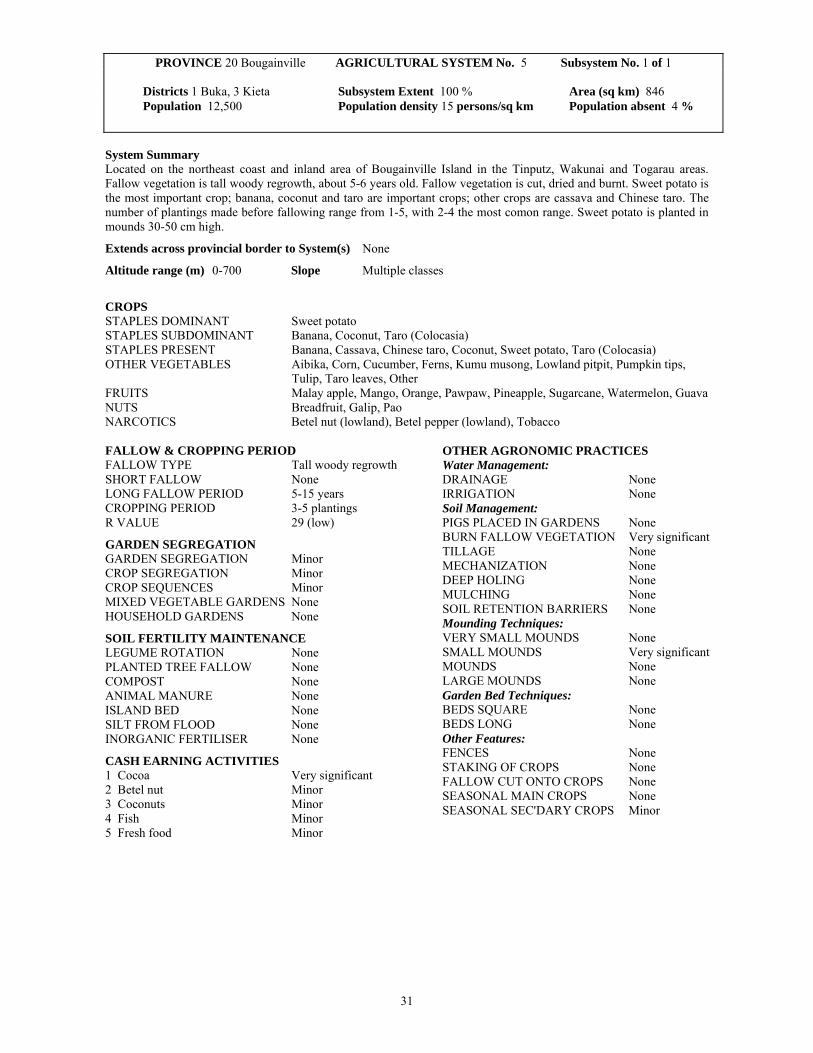
31
System Summary Located on the northeast coast and inland area of Bougainville Island in the Tinputz, Wakunai and Togarau areas. Fallow vegetation is tall woody regrowth, about 5-6 years old. Fallow vegetation is cut, dried and burnt. Sweet potato is the most important crop; banana, coconut and taro are important crops; other crops are cassava and Chinese taro. The number of plantings made before fallowing range from 1-5, with 2-4 the most comon range. Sweet potato is planted in mounds 30-50 cm high.
Extends across provincial border to System(s) None
Altitude range (m) 0-700 Slope Multiple classes
CROPS STAPLES DOMINANT Sweet potato STAPLES SUBDOMINANT Banana, Coconut, Taro (Colocasia) STAPLES PRESENT Banana, Cassava, Chinese taro, Coconut, Sweet potato, Taro (Colocasia) OTHER VEGETABLES Aibika, Corn, Cucumber, Ferns, Kumu musong, Lowland pitpit, Pumpkin tips,
Tulip, Taro leaves, Other FRUITS Malay apple, Mango, Orange, Pawpaw, Pineapple, Sugarcane, Watermelon, Guava NUTS Breadfruit, Galip, Pao NARCOTICS Betel nut (lowland), Betel pepper (lowland), Tobacco FALLOW & CROPPING PERIOD FALLOW TYPE Tall woody regrowth SHORT FALLOW None LONG FALLOW PERIOD 5-15 years CROPPING PERIOD 3-5 plantings R VALUE 29 (low)
GARDEN SEGREGATION GARDEN SEGREGATION Minor CROP SEGREGATION Minor CROP SEQUENCES Minor MIXED VEGETABLE GARDENS None HOUSEHOLD GARDENS None
SOIL FERTILITY MAINTENANCE LEGUME ROTATION None PLANTED TREE FALLOW None COMPOST None ANIMAL MANURE None ISLAND BED None SILT FROM FLOOD None INORGANIC FERTILISER None
CASH EARNING ACTIVITIES 1 Cocoa Very significant 2 Betel nut Minor 3 Coconuts Minor 4 Fish Minor 5 Fresh food Minor
OTHER AGRONOMIC PRACTICES Water Management: DRAINAGE None IRRIGATION None Soil Management: PIGS PLACED IN GARDENS None BURN FALLOW VEGETATION Very significant TILLAGE None MECHANIZATION None DEEP HOLING None MULCHING None SOIL RETENTION BARRIERS None Mounding Techniques: VERY SMALL MOUNDS None SMALL MOUNDS Very significant MOUNDS None LARGE MOUNDS None Garden Bed Techniques: BEDS SQUARE None BEDS LONG None Other Features: FENCES None STAKING OF CROPS None FALLOW CUT ONTO CROPS None SEASONAL MAIN CROPS None SEASONAL SEC'DARY CROPS Minor
PROVINCE 20 Bougainville AGRICULTURAL SYSTEM No. 5 Subsystem No. 1 of 1 Districts 1 Buka, 3 Kieta Subsystem Extent 100 % Area (sq km) 846 Population 12,500 Population density 15 persons/sq km Population absent 4 %

32
OTHER DOCUMENTATION Survey description In December 1980, a road traverse and garden visits from Kieta to Wakunai and Togarau (1 day). In August-October 1996, interviews with three informants from the Tinputz-Teop and Wakunai areas. Boundary definition The boundary with System 2003 near Baniu is based on the extent of flat raised coral reefs. This estimate was confirmed by interviews with people from Buka Island and the Tinputz area. The southern boundary with System 2007 was taken as the Pukarobi River and is an estimate only. This system was distinguished from System 2006 to the west after interviews with three people from the east coast and a group of people from the west coast. The boundary with System 2006 was taken as the 600 m contour and is an estimate only. Notes This system is almost identical to that used to the north and on Buka Island (System 2003), but garden segregation is more important there and there is a weak tendency for more plantings to be made in this system before fallowing. It is also very similar to the system on the west coast (System 2006) where cassava is an important food, but taro is less important. This system is distinguished from that to the south (System 2007) where generally only one planting is made before fallowing and Chinese taro is an important crop. Fallow vegetation is tall woody regrowth, about 10-15 m high. Fallow periods are probably 4-8 years, but this is uncertain. The number of plantings made before fallowing varies between locations. In the Teop area, two plantings are said to be the most common practice; two or three plantings are made in the Ruruvu area; and three or four plantings on the volcanic ash soil in the Baniu area. In the inland areas where population pressure is less, one or two plantings only are made before fallowing. Occasionally, a planting of taro will be followed with one or more sweet potato plantings. Sweet potato is the most important food. It had become dominant after taro was devastated by taro blight. There is some resurgence in taro planting and more is said to be eaten in the 1990s than during the 1970s and 1980s. The relative importance of the staple foods varies between locations. Taro and Chinese taro are more important in inland locations. A little rice was grown during the crisis years of the early 1990s, but production had ceased by 1996. Cassava is used to prepare puddings. A little sago is eaten. When food was scarce during the crisis period, some wild yam were gathered and eaten. Fish is a reasonably important food in coastal locations. Page et al. (1987) surveyed foods eaten in a number of different communities in North Solomons. On Bougainville, the areas chosen for the study were Nasioi, Nagovisi and Aita. Aita, located inland on the northern end of the island in this system and away from the money of the Bougainville Copper Mine stood out in the comparison. People in the Aita area ate substantially more taro and yam than did those living in Nagovisi and Nasioi. For example, 78 per cent claimed they ate 'plenty' of taro compared with 12 per cent in Nasioi and 4 per cent in Nagovisi. People in Nagovisi and Nasioi ate substantially more introduced (or purchased) foods. For example, 86 per cent of people in Nasioi and 90 per cent in Nagovisi claimed they ate 'plenty' of rice compared with only 21 per cent in Aita. Minor vegetable crops include amaranthus, Chinese cabbage, snake bean, karakap, peanuts, kangkong, Chinese taro leaves, sweet potato leaves, ginger, spring onion, watercress, winged bean, tomato, eggplant and capsicum. Choko tips are a more important vegetable in inland locations. Minor fruits include golden apple, mandarin, pomelo, soursop, custard apple, ton, avocado and rambutan. Galip and pao are common nut trees with Java almond eaten on the coast. Polynesian chestnut is a minor nut tree. Both the flesh and fruit of breadfruit are eaten. Tobacco is mainly grown by Sepik settlers. Fences are rarely made, except in the Tinputz area. Corn, cucumber and watermelon are planted in the middle of the year and harvested in October-December. Other crops are not planted seasonally. There is quite a lot of variation in agricultural practices employed in this system, and this variation is largely dependent on soil type and altitude. Monsen (1975, 12-13) reported that the mountain and hill peoples grew the best taro. Similarly, Dearden and Freyne (n.d.) found that the people of Iuan village only grew taro on higher ground, whilst sweet potato was grown on the lower slopes and in the low flat areas. Furthermore, Monsen (1975, 7) argued that the people of Tearaka have always traded with the inland people, exchanging fish for taro. This indicates that variation in agricultural practices may have existed in this agricultural system for quite some time. A fungal disease of taro (taro blight) arrived on Bougainville immediately prior to the Japanese invasion in 1942. The disease spread throughout all of Buka and Bougainville, and devastated taro production. Villagers switched to sweet potato as their staple food everywhere on Bougainville and Buka (Packard 1975).
PROVINCE 20 Bougainville AGRICULTURAL SYSTEM No. 5 Subsystem No. 1 of 1

33
PROVINCE 20 Bougainville AGRICULTURAL SYSTEM No. 5 Subsystem No. 1 of 1
Notes continued At Iaun, it was found that two crops of taro were generally grown before the taro gardens were left to fallow (Dearden and Freyne n.d.). In the low lying areas, three plantings of sweet potato were usually made before fallowing. Sweet potato was always interplanted with other crops including: taro, Chinese taro, yam, cassava, banana, corn, pitpit, coconut, pawpaw, sugarcane, watermelon, beans, peanuts, pumpkin, aibika, European cabbage, cucumber, onion, spring onion, tomato and tobacco (Dearden and Freyne n.d.; Monsen 1975, 11-12). Upon completion of the cropping sequence, the sweet potato gardens were often turned over to coconut or cocoa. At Tearaka, new gardens were made by cutting the bush, allowing it to dry, and then burning it (Monsen 1975, 11). Taro was planted in holes made with digging sticks, whilst sweet potato was planted in mounds constructed with hoes and spades. At Togarau village, Dearden and Freyne (n.d.) found that it was common practice to allow the cut bush to rot for up to six years before burning it and establishing a new garden. Moreover, it was also reported that some farmers in Togarau had established ‘permanent’ gardens (Dearden and Freyne n.d.). One such garden, from which six consecutive crops had successfully been cultivated, was examined, and the crops were found to be in good health. Importantly, Dearden and Freyne (n.d.) found that Iaun village was susceptible to periodic food shortages as a result of crop damage caused by pigs and heavy rainfall. Cash cropping has been carried out throughout this agricultural system since the 1950s (Rutherford 1977; Dearden and Freyne n.d.). Copra and cocoa have been the primary cash crops, although coffee and garden vegetables have also been important in some areas (Rutherford 1977). Dearden and Freyne (n.d.) and Monsen (1975, 13) reported that the sale of garden vegetables was an important secondary source of cash income in Togarau and Tearaka respectively. In some areas, most of the land close to villages has been put under coconut and cocoa, with the result that subsistence gardens have been pushed further away from the villages (Dearden and Freyne n.d.; Monsen 1975, 16-17, 27-29). This region was, and remains, the main cocoa producing area in North Solomons Province. Cocoa is the main source of cash income. Village production has continued throughout the crisis, although it collapsed in 1994-95 because of transport and marketing problems. Between 1991 and 1994, cocoa sales were worth about K800 per household per year (estimates derived from Cocoa Board figures). Some copra is produced and sold, but production has declined in recent years because of poor returns. There has been considerable damage to the plantations in this region and most infrastructure on them have been destroyed. Some harvesting is occurring by villagers, but all plantations have been abandoned by management. Some betel nut is sold at Buka Passage. A little is taken to Lae and Port Moresby for sale, and this continued even during the crisis period of the early 1990s. Some fresh food is sold locally. Prior to the crisis, potatoes and temperate fruit and vegetables, such as cabbage, carrot and strawberry, were grown in the Togarau area, but this production has probably ceased because of lack of demand. Fish also provides some cash income, especially for Teop Island people. The traditional exchange of fish and garden food between coastal and inland people was revived during the crisis years. A little tobacco provides some cash income, particularly for those few remaining people of Sepik origin. Cardamom was trialled in the mountainous areas and some sold prior to the crisis, but it is no longer being produced. National Nutrition Survey 1982/83 In this province, the survey was conducted during 1980 and no dietary recall information was collected. Main References None. Other References Dearden, P.N. and D.F. Freyne n.d. Land use: a rapid rural appraisal, North Solomons Province. Unpublished paper, Land Use Section, Department of Primary Industry, Port Moresby. Monsen, J. 1975 Tearaka - a case study of village change on Bougainville. Student Research Papers No. 2, Department of Geography, University of Papua New Guinea, Port Moresby. Packard, J.C. 1975 The Bougainville taro blight. Miscellaneous Working Papers 1975: 1, Pacific Islands Program, University of Hawaii. Page, L.B., J.G. Rhoads, J.S. Friedlaender, J.R. Page and K. Curtis 1987 Diet and nutrition. In Friedlaender, J.S. (ed), The Solomon Islands Project: A Long-term Study of Health, Human Biology, and Culture Change. Oxford, Clarendon Press, 65-88.

34
PROVINCE 20 Bougainville AGRICULTURAL SYSTEM No. 5 Subsystem No. 1 of 1
Other References continued Rutherford, J. 1977 'Zen' affluence in a subsistence economy of Bougainville, Solomon Islands. In Hirst, I.R.C. and W.D. Reekie (eds), The Consumer Society. London, Tavistock, 91-116. Scott, R.M., P.B. Heyligers, J.R. McAlpine, J.C. Saunders and J.G. Speight 1967 Lands of Bougainville and Buka Islands, Territory of Papua and New Guinea. Land Research Series No. 20, Commonwealth Scientific and Industrial Research Organization, Melbourne.
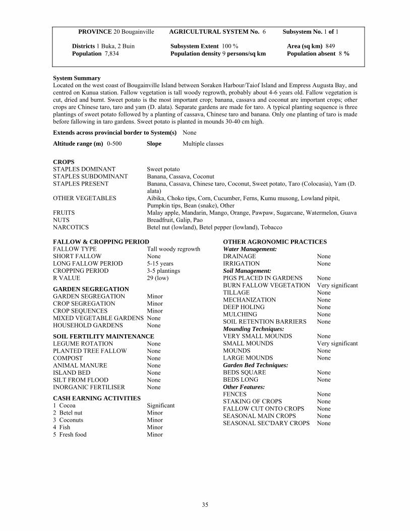
35
System Summary Located on the west coast of Bougainville Island between Soraken Harbour/Taiof Island and Empress Augusta Bay, and centred on Kunua station. Fallow vegetation is tall woody regrowth, probably about 4-6 years old. Fallow vegetation is cut, dried and burnt. Sweet potato is the most important crop; banana, cassava and coconut are important crops; other crops are Chinese taro, taro and yam (D. alata). Separate gardens are made for taro. A typical planting sequence is three plantings of sweet potato followed by a planting of cassava, Chinese taro and banana. Only one planting of taro is made before fallowing in taro gardens. Sweet potato is planted in mounds 30-40 cm high.
Extends across provincial border to System(s) None
Altitude range (m) 0-500 Slope Multiple classes
CROPS STAPLES DOMINANT Sweet potato STAPLES SUBDOMINANT Banana, Cassava, Coconut STAPLES PRESENT Banana, Cassava, Chinese taro, Coconut, Sweet potato, Taro (Colocasia), Yam (D.
alata) OTHER VEGETABLES Aibika, Choko tips, Corn, Cucumber, Ferns, Kumu musong, Lowland pitpit,
Pumpkin tips, Bean (snake), Other FRUITS Malay apple, Mandarin, Mango, Orange, Pawpaw, Sugarcane, Watermelon, Guava NUTS Breadfruit, Galip, Pao NARCOTICS Betel nut (lowland), Betel pepper (lowland), Tobacco FALLOW & CROPPING PERIOD FALLOW TYPE Tall woody regrowth SHORT FALLOW None LONG FALLOW PERIOD 5-15 years CROPPING PERIOD 3-5 plantings R VALUE 29 (low)
GARDEN SEGREGATION GARDEN SEGREGATION Minor CROP SEGREGATION Minor CROP SEQUENCES Minor MIXED VEGETABLE GARDENS None HOUSEHOLD GARDENS None
SOIL FERTILITY MAINTENANCE LEGUME ROTATION None PLANTED TREE FALLOW None COMPOST None ANIMAL MANURE None ISLAND BED None SILT FROM FLOOD None INORGANIC FERTILISER None
CASH EARNING ACTIVITIES 1 Cocoa Significant 2 Betel nut Minor 3 Coconuts Minor 4 Fish Minor 5 Fresh food Minor
OTHER AGRONOMIC PRACTICES Water Management: DRAINAGE None IRRIGATION None Soil Management: PIGS PLACED IN GARDENS None BURN FALLOW VEGETATION Very significant TILLAGE None MECHANIZATION None DEEP HOLING None MULCHING None SOIL RETENTION BARRIERS None Mounding Techniques: VERY SMALL MOUNDS None SMALL MOUNDS Very significant MOUNDS None LARGE MOUNDS None Garden Bed Techniques: BEDS SQUARE None BEDS LONG None Other Features: FENCES None STAKING OF CROPS None FALLOW CUT ONTO CROPS None SEASONAL MAIN CROPS None SEASONAL SEC'DARY CROPS None
PROVINCE 20 Bougainville AGRICULTURAL SYSTEM No. 6 Subsystem No. 1 of 1 Districts 1 Buka, 2 Buin Subsystem Extent 100 % Area (sq km) 849 Population 7,834 Population density 9 persons/sq km Population absent 8 %

36
OTHER DOCUMENTATION Survey description In October 1996, interviews with three informants as a group from the Kunua area. Information was provided on the region from Soraken Harbour and Taiof Island to Korepovi village (Cape Moltke). No information is available for the Soraken Harbour to Empress Augusta Bay area. No field visits were made. Boundary definition The boundary with System 2003 between Baniu and Soraken Harbour is based on the extent of the flat raised coral reefs of Buka Island and Buka Passage, and was confirmed by interviews. This system was distinguished from System 2005 to the east after interviews with three people from the east coast and a group of people from the west coast. The boundary was taken as the 600 m contour and is an estimate only. The boundary with System 2007 was taken as the Crown Prince Range. The southern boundary with System 2008 is an estimate only as agriculture in the Cape Moltke-Empress Augusta Bay area is presumed to be similar to that between Soraken Harbour and Cape Moltke. Notes This system is very similar to nearby ones on Buka and Bougainville. It is distinguished from Systems 2003, 2005 and 2008 where cassava is not an important crop. The system is very different from that used on the small islands west of Buka (System 2004) where land use is more intensive and fallow periods are only about one year long. This system is distinguished from those used in southeast and south Bougainville (Systems 2007 and 2009) where usually only one planting is made before land is fallowed. People are reported to shift village sites from time to time. Hence they clear land after very long fallows of several decades and then gardens are moved within this area for some years. Fallow periods are unknown but informants' descriptions of fallow vegetation suggest about 4-6 years. A typical sequence is said to be three plantings of sweet potato followed by a planting of cassava, banana and Chinese taro. Coconut cream is used to cook food daily, but they are reported to be used less in the southern part of the system. River fish, reef fish and prawns are commonly eaten. On Taiof Island, cassava is said to be a more important food than sweet potato. Not a lot of taro is grown in this system now. It was the most important staple prior to 1941, as it was for all Bougainville. Minor vegetables include the young shoots and leaves of Chinese taro, taro and sweet potato; and amaranthus, watercress, kangkong, karakap and mushrooms. Minor fruits and nuts include soursop, pomelo and Polynesian chestnut. Little literature exists on the agricultural activities in this system. Oliver (n.d., 7), after fieldwork on Bougainville Island in 1938-39, described the ‘Bougainville cultures’ as appearing ‘remarkably uniform’. Basically, they relied primarily on gardening for subsistence, with taro as the dominant staple and sweet potato next in importance in most areas; yams were grown and some sago was collected. Hunting, fishing, wild-plant collecting and pig raising were of secondary importance. When in season, galip (canarium) and breadfruit were eaten. Gardens were cleared, planted and fallowed on a rotation basis, with taro planting and harvesting a year-round activity. Three significant events since that time have seen this uniformity altered. These events were: taro blight during World War II, after which sweet potato replaced taro as the dominant staple crop in most places; the introduction of cash cropping; and the development of the Bougainville Copper Mine. Ward (1975, 26) gives a brief description of crops grown in the Buin subdistrict, part of which forms the southern half of this system. Sweet potato and yams replaced taro as the dominant staples after taro blight killed off taro during World War II; other crops grown were banana, sugarcane, pawpaw, pitpit, breadfruit, coconut, cassava, corn, tomato, pineapple, bean and tobacco. Sago was also eaten. Several attempts were made to introduce various crops for income purposes but were unsuccessful. By far the most successful introduction was that of cacao in about 1959 (Ward 1975, 27). Cocoa and, to a lesser degree, copra are now the main sources of cash income. Since the Bougainville crisis, less cocoa and copra has been produced because of transport constraints. The plantations in this region have been abandoned because of the crisis and are overgrown. Other sources of cash income are fresh food which is sold locally; fish and betel nut which are sold locally and in Buka Passage market; and bêche-de-mer. There is likely to be less cash cropping in the Cape Moltke-Empress Augusta Bay region because of transport constraints and lack of road access to Buka Passage.
PROVINCE 20 Bougainville AGRICULTURAL SYSTEM No. 6 Subsystem No. 1 of 1

37
PROVINCE 20 Bougainville AGRICULTURAL SYSTEM No. 6 Subsystem No. 1 of 1
National Nutrition Survey 1982/83 In this province, the survey was conducted during 1980 and no dietary recall information was collected. Main References None. Other References Oliver, D.L. n.d. Somatic Variability and Human Ecology on Bougainville, Solomon Islands. Cambridge, MA, Harvard University. Packard, J.C. 1975 The Bougainville taro blight. Miscellaneous Working Papers 1975: 1, Pacific Islands Program, University of Hawaii. Scott, R.M., P.B. Heyligers, J.R. McAlpine, J.C. Saunders and J.G. Speight 1967 Lands of Bougainville and Buka Islands, Territory of Papua and New Guinea. Land Research Series No. 20, Commonwealth Scientific and Industrial Research Organization, Melbourne. Ward, M.W. 1975 Road and development in southwest Bougainville. New Guinea Research Bulletin No. 62, New Guinea Research Unit, Australian National University, Port Moresby and Canberra.

38
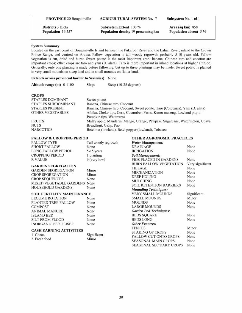
39
System Summary Located on the east coast of Bougainville Island between the Pukarobi River and the Laluai River, inland to the Crown Prince Range, and centred on Arawa. Fallow vegetation is tall woody regrowth, probably 5-10 years old. Fallow vegetation is cut, dried and burnt. Sweet potato is the most important crop; banana, Chinese taro and coconut are important crops; other crops are taro and yam (D. alata). Taro is more important in inland locations at higher altitude. Generally, only one planting is made before fallowing, but up to three plantings may be made. Sweet potato is planted in very small mounds on steep land and in small mounds on flatter land.
Extends across provincial border to System(s) None
Altitude range (m) 0-1100 Slope Steep (10-25 degrees)
CROPS STAPLES DOMINANT Sweet potato STAPLES SUBDOMINANT Banana, Chinese taro, Coconut STAPLES PRESENT Banana, Chinese taro, Coconut, Sweet potato, Taro (Colocasia), Yam (D. alata) OTHER VEGETABLES Aibika, Choko tips, Corn, Cucumber, Ferns, Kumu musong, Lowland pitpit,
Pumpkin tips, Watercress FRUITS Malay apple, Mandarin, Mango, Orange, Pawpaw, Sugarcane, Watermelon, Guava NUTS Breadfruit, Galip, Pao NARCOTICS Betel nut (lowland), Betel pepper (lowland), Tobacco FALLOW & CROPPING PERIOD FALLOW TYPE Tall woody regrowth SHORT FALLOW None LONG FALLOW PERIOD 5-15 years CROPPING PERIOD 1 planting R VALUE 9 (very low)
GARDEN SEGREGATION GARDEN SEGREGATION Minor CROP SEGREGATION Minor CROP SEQUENCES None MIXED VEGETABLE GARDENS None HOUSEHOLD GARDENS None
SOIL FERTILITY MAINTENANCE LEGUME ROTATION None PLANTED TREE FALLOW None COMPOST None ANIMAL MANURE None ISLAND BED None SILT FROM FLOOD None INORGANIC FERTILISER None
CASH EARNING ACTIVITIES 1 Cocoa Significant 2 Fresh food Minor
OTHER AGRONOMIC PRACTICES Water Management: DRAINAGE None IRRIGATION None Soil Management: PIGS PLACED IN GARDENS None BURN FALLOW VEGETATION Very significant TILLAGE None MECHANIZATION None DEEP HOLING None MULCHING None SOIL RETENTION BARRIERS None Mounding Techniques: VERY SMALL MOUNDS Significant SMALL MOUNDS Minor MOUNDS None LARGE MOUNDS None Garden Bed Techniques: BEDS SQUARE None BEDS LONG None Other Features: FENCES Minor STAKING OF CROPS None FALLOW CUT ONTO CROPS None SEASONAL MAIN CROPS None SEASONAL SEC'DARY CROPS None
PROVINCE 20 Bougainville AGRICULTURAL SYSTEM No. 7 Subsystem No. 1 of 1 Districts 3 Kieta Subsystem Extent 100 % Area (sq km) 858 Population 16,557 Population density 19 persons/sq km Population absent 5 %

40
OTHER DOCUMENTATION Survey description In December 1980, a road traverse between Kieta and Panguna with garden visits (1 day). In August and October 1996, interviews with three people from the Kieta, Arawa ad Panguna areas. Boundary definition The northern boundary with System 2005 is taken as the Pukarobi River; that with System 2009 is near the Laluai River; that with Systems 2006 and 2008 is the Crown Prince Range. All boundaries are estimates based on interviews, not field traverses, and are not precise. Notes This system is distinguished from those to the north (System 2005) and to the west (Systems 2006 and 2008) where 2-4 plantings are made before fallowing and Chinese taro is not an important crop. It is similar to that used in South Bougainville (System 2009) except that fallow periods seem to be shorter there (2-5 years) and fallow vegetation is shorter. The Bougainville crisis has had a major impact on the economy in this system. The most important known effect on agriculture has been the collapse of cash cropping. Fallow periods were reported as 1-4 years, but from descriptions of vegetation are probably in the range of 5-10 years. Generally, only one planting is made before fallowing, but two or three plantings may be made. In inland areas, separate gardens may be made for taro and sweet potato. Elsewhere, Chinese taro, taro and sweet potato tend to be planted in separate sections of gardens. Taro is more common in the inland mountainous part of the system than near the coast. Some cassava and rice are also grown and occasionally sago is produced and eaten. Minor vegetables reported include tulip, taro leaves, snake bean, peanuts, Chinese cabbage, capsicum, spring onion and tomato. Minor fruits are pineapple, rambutan, granadilla and avocado. On steeper land, sweet potato is planted with a digging stick without mounding. Small mounds are made with spades on flat land. Sticks are laid around the contour to delineate plots within gardens, but they do not seem to serve a soil erosion control purpose. Some river fish and reef fish are eaten. Barter occurs between inland and coastal villagers. The coastal people provide coconuts while the inland people give taro and choko tips. Prior to the Bougainville crisis, coastal people provided store food and clothing. The main language group lying within this system is the Nasioi language group. A brief description of the agricultural practices of the Nasioi is given by Ogan (1972). He reported four main stages of garden establishment: heavy clearing of fallow vegetation, including felling of trees; clearing shrubs and vines and placing the cut material into heaps around the garden site; final clearing of the garden site and burning of the heaps; and, the final stage, planting. Fences were constructed around gardens to keep pigs out. Fence building took place before the burning stage in garden establishment (Ogan 1972, 24-26). In the 1990s, informants reported that gardens are not usually fenced as pigs are kept in areas separate from food gardens. Prior to World War II, taro was the dominant staple. Only one planting was made before fallowing land, deterioration of fencing played as big a role in garden abandonment as did the decline in soil fertility (Ogan 1972, 25-26). Bananas, which were planted in taro gardens, continued to be harvested for 1-2 years after garden abandonment (Ogan 1972, 25). At the time of Ogan’s fieldwork, the most important crops grown were sweet potato, yam and banana; other crops grown were tomato, pineapple, cucumber, scallions and other green vegetables (Ogan 1972, 118). The introduction of cash crops also involved changes in the subsistence gardening practices. Firstly, the size and distribution of gardens changed. A larger area of land was required for growing coconut and cacao trees than for a subsistence garden. Therefore, several subsistence gardens were made in a single area of cleared land, before the land was left to the cash crops. Secondly, the larger garden areas required also made fencing a more difficult task and the Nasioi chose to give up pigs until the trees were large enough, rather than fence the gardens (Ogan 1972, 118). Unlike the Nagovisi, the Nasioi did not choose to fence the pigs in (Ogan 1972, 119). One other change from traditional practices was the introduction of metal tools. As an example, women occasionally used iron rods instead of the traditional wooden digging stick (Ogan 1972, 116).
PROVINCE 20 Bougainville AGRICULTURAL SYSTEM No. 7 Subsystem No. 1 of 1

41
PROVINCE 20 Bougainville AGRICULTURAL SYSTEM No. 7 Subsystem No. 1 of 1
Notes continued Galip nut and betel nut are consumed by the Nasioi, however the plants were apparently not cultivated (Ogan 1972, 25). Fishing and hunting (for birds, possums and pigs) were carried out on a casual basis (Ogan 1972, 129). Foods purchased with money included rice, tinned fish, tinned meat, and sweet and salted biscuits (Ogan 1972, 148). Connell and Hamnett (1978) reviewed sago production on Bougainville. They reported that it was produced regularly as part of the normal diet in the Siwai (System 2008) and Eivo (this system) language areas and, to a lesser extent, in other parts of Bougainville. The average garden size over all of Bougainville was estimated as 2 acres per annum under cultivation (Moulik 1977, 29). However, garden sizes tended to be smaller in the Kieta District (this system) that in the Buin District (System 2009). In the Kieta area, gardens tended to be located on gentle upper slopes of hills, broad ridge tops and stream terraces (Moulik 1977, 29). Development of the Bougainville Copper Mine also brought about changes during the 1970s and 1980s. The mine had a policy that as much as possible of the fresh food requirements of the workforce be purchased from local sources (Moulik 1977, 28). This policy had a number of substantial impacts on agricultural activities in the Kieta District. Firstly, new crops were introduced to cater for the tastes of the mine’s workforce. These new crops included: tomato, onions, pumpkin, pineapple, maize, eggplant, beans, potato, cabbage, watermelon, mandarin and oranges (Moulik 1977, 29). Traditional gardening methods, however, continued to be used. Secondly, the loss of man-power as more men gained wage employment, meant that less attention was paid to cash crops and production decreased (Moulik 1977, 37). Pig raising also became less important, for a variety of reasons, and many households no longer kept pigs. Construction of the Bougainville Copper Mine resulted in the relocation of some villages. Applied Geology Associates (1989) undertook a study of these villages and their gardens. It was found that a greater incidence of disease and poor production of certain crops occurred in these relocated village when compared with villages located further away from the mine. Applied Geology Associates (1989, 5.36-5.37) suggested two main reasons for this: firstly, reduced access to land meant that gardens could not be moved as frequently; and secondly, with the increased flow of cash, less attention was paid to gardens. An Atolls Resettlement Scheme operated from 1984. Carteret Islanders resettled at Kuveria, 30 km from Arawa along the Kieta-Buka Highway (Kukang et al. 1987; O’Collins 1990). All the settlers reportedly had left the scheme in the late 1980s, prior to the Bougainville crisis. Page et al. (1987) conducted a study of foods eaten by a number of different communities in North Solomons. On Bougainville, the areas chosen for the study were Nasioi (this system), Nagovisi (System 2008) and Aita (System 2005). Aita, located inland on the northern end of the island and away from the money of the Bougainville Copper Mine certainly stood out in the comparison. People in the Aita area ate substantially more taro and yam than did those living in Nagovisi and Nasioi. For example, 78 per cent claimed they ate ‘plenty’ of taro compared with 12 per cent in Nasioi and 4 per cent in Nagovisi. People in Nagovisi and Nasioi ate substantially more introduced (or purchased) foods. For example, 86 per cent of people in Nasioi and 90 per cent in Nagovisi claimed they ate ‘plenty’ of rice compared with only 21 per cent in Aita. The main cash crop grown in the Nasioi area in the early 1970s was coconut, for the production of copra, though it was not cultivated until during the German administration (Ogan 1972, 25). There was some cacao grown in the area, but it was not so widely nor so uniformly distributed as coconut. This was mainly because of the greater care required to grow cacao trees, due to their need for shading, and because they produced for fewer years than coconut trees (Ogan 1972, 125). Lea (1970) conducted a study of activities in a number of villages in Papua New Guinea, including Pavaese near Kieta. He reported that it was the most cash-oriented village in the study and that considerable areas of the village were planted with cocoa and coconuts. Prior to the Bougainville crisis, cocoa, copra and marketed food provided signficant cash income. Some temperate climate vegetables were also grown for sale in Arawa. The cash economy largely collapsed as a result of the Bougainville crisis. In 1996, some fresh food, seafood and fish were being marketed in Arawa and in the nearby government controlled area. Pig meat, chickens and ducks also provided a little income. By late 1998, production and sale of cocoa had commenced again. Minor quantities of bêche-de-mer were sold occasionally. Villagers were bartering garden produce for manufactured household needs such as soap, sugar and kerocene.

42
PROVINCE 20 Bougainville AGRICULTURAL SYSTEM No. 7 Subsystem No. 1 of 1
National Nutrition Survey 1982/83 In this province, the survey was conducted during 1980 and no dietary recall information was collected. Main References None. Other References Applied Geology Associates 1989 Environmental, Socio-economic and Public Health Review of Bougainville Copper Mine, Panguna. Applied Geology Associates Limited, New Zealand. Connell, J. and M.P. Hamnett 1978 Famine or feast: sago production in Bougainville. Journal of the Polynesian Society 87, 3, 231-241. Kukang, T., E. Tade, J. Selwyn, A. Siau and M. Wairiu 1987 The Atolls Resettlement Scheme: Kuveria, North Solomons Province. In O'Collins, M. (ed), Rapid Rural Appraisal: Case Studies of Small Farming Systems. Port Moresby, Department of Anthropology and Sociology, University of Papua New Guinea, 65-92. Lea, D.A.M. 1969-70 Activities studies in New Guinea villages. Papua and New Guinea Agricultural Journal 21, 3-4, 118-126. Moulik, T.K. 1977 Bougainville in Transition. Canberra, Development Studies Centre, Australian National University. O'Collins, M. 1990 Carteret islanders at the Atolls Resettlement Scheme: a response to land loss and population growth. In Pernetta, J.C. and P.J. Hughes (eds), Implications of expected climate changes in the South Pacific region: an overview. UNEP Regional Seas Reports and Studies No. 128. Nairobi, United Nations Environment Program, 247-269. Ogan, E. 1972 Business and cargo: socio-economic change among the Nasioi of Bougainville. New Guinea Research Bulletin No. 44, New Guinea Research Unit, Australian National University, Port Moresby and Canberra. Ogan, E. 1996 Copra came before copper: the Nasioi of Bougainville and plantation colonialism, 1902-1964. Pacific Studies 91, 1, 31-51. Packard, J.C. 1975 The Bougainville taro blight. Miscellaneous Working Papers 1975: 1, Pacific Islands Program, University of Hawaii. Page, L.B., J.G. Rhoads, J.S. Friedlaender, J.R. Page and K. Curtis 1987 Diet and nutrition. In Friedlaender, J.S. (ed), The Solomon Islands Project: A Long-term Study of Health, Human Biology, and Culture Change. Oxford, Clarendon Press, 65-88. Scott, R.M., P.B. Heyligers, J.R. McAlpine, J.C. Saunders and J.G. Speight 1967 Lands of Bougainville and Buka Islands, Territory of Papua and New Guinea. Land Research Series No. 20, Commonwealth Scientific and Industrial Research Organization, Melbourne.

43
System Summary Located in southwest Bougainville, bounded by Empress Augusta Bay, the Crown Prince Range and the Mivo River, and centered on Boku station. Fallow vegetation is tall woody regrowth, typically 4-8 years old. Some previous unused forest has been cleared during the Bougainville crisis. Fallow vegetation is cut, dried and burnt. Sweet potato is the most important crop; banana and coconut are important crops; other crops are Chinese taro, cassava, sago, yam (D. alata), taro and rice. Two to four plantings are made before land is fallowed. Sweet potato is usually planted in mounds about 30-40 cm high.
Extends across provincial border to System(s) None
Altitude range (m) 0-950 Slope Gentle (2-10 degrees)
CROPS STAPLES DOMINANT Sweet potato STAPLES SUBDOMINANT Banana, Coconut STAPLES PRESENT Banana, Cassava, Chinese taro, Coconut, Sago, Sweet potato, Taro (Colocasia),
Yam (D. alata), Other OTHER VEGETABLES Aibika, Choko tips, Corn, Cucumber, Ferns, Kumu musong, Lowland pitpit,
Pumpkin tips, Tulip, Bean (snake) FRUITS Malay apple, Mango, Pawpaw, Pineapple, Sugarcane, Watermelon, Guava NUTS Breadfruit, Galip, Pao NARCOTICS Betel nut (lowland), Betel pepper (lowland), Tobacco FALLOW & CROPPING PERIOD FALLOW TYPE Tall woody regrowth SHORT FALLOW None LONG FALLOW PERIOD 5-15 years CROPPING PERIOD 3-5 plantings R VALUE 29 (low)
GARDEN SEGREGATION GARDEN SEGREGATION None CROP SEGREGATION Minor CROP SEQUENCES None MIXED VEGETABLE GARDENS None HOUSEHOLD GARDENS None
SOIL FERTILITY MAINTENANCE LEGUME ROTATION None PLANTED TREE FALLOW None COMPOST None ANIMAL MANURE None ISLAND BED None SILT FROM FLOOD None INORGANIC FERTILISER None
CASH EARNING ACTIVITIES 1 Cocoa Significant 2 Fresh food Minor 3 Pig meat Minor
OTHER AGRONOMIC PRACTICES Water Management: DRAINAGE None IRRIGATION None Soil Management: PIGS PLACED IN GARDENS None BURN FALLOW VEGETATION Very significant TILLAGE None MECHANIZATION None DEEP HOLING None MULCHING None SOIL RETENTION BARRIERS None Mounding Techniques: VERY SMALL MOUNDS Minor SMALL MOUNDS Very significant MOUNDS None LARGE MOUNDS None Garden Bed Techniques: BEDS SQUARE None BEDS LONG None Other Features: FENCES Minor STAKING OF CROPS None FALLOW CUT ONTO CROPS None SEASONAL MAIN CROPS Minor SEASONAL SEC'DARY CROPS Minor
PROVINCE 20 Bougainville AGRICULTURAL SYSTEM No. 8 Subsystem No. 1 of 1 Districts 2 Buin Subsystem Extent 100 % Area (sq km) 1179 Population 23,122 Population density 20 persons/sq km Population absent 4 %
44
OTHER DOCUMENTATION Survey description In June-October 1996, interviews with four people from the Nagovisi and Siwai areas. No field visits were made. Boundary definition The boundary with System 2006 is in the Empress Augusta Bay area; that with System 2007 is the Crown Prince Range; and that with System 2009 is the Mivo River. All boundaries are based on interviews and are not precise. Notes This system is very similar to System 2006 to the northwest but cassava is an important food there. It is distinguished from the systems to the east and southeast (Systems 2007 and 2009) where generally only one planting is made before fallowing and Chinese taro is an important crop. The Bougainville crisis (1989-1997) has had a major impact on southwest Bougainville. However, conditions were becoming more normal by late 1996. Many people in the Siwai language area had been living in national government controlled care centres and some were dependent on rice for food supplied by the government. By late 1996, it was reported that virtually all villages in this system were producing their own food. The crisis has resulted in the collapse of the cash economy, particularly cocoa production. Many villagers have moved into forested areas to avoid fighting. Food gardens are reported to be larger now because of the unavailablity of imported food. People were growing some rice for subsistence; growing more tobacco than pre-crisis; and eating more self sown foods, including ferns, ficus leaves, wild yams and the basal portion of a wild banana-type plant. Fallow periods are typically 4-8 years long. Because of the crisis situation, many people have moved further from villages and roads and are making food gardens in previously unused forest. It is not known what proportion of gardens are being cleared from previously unused forest. Fallow periods have become much shorter since the late 1960s-early 1970s when Mitchell (1976, 24-25) reported that some gardens followed fallows 20 or more years in length. Three persons interviewed reported that two or three plantings were made before fallowing and a fourth informant stated that three or four plantings were made. Hence the range is reported here as 2-4 plantings. Some river fish are eaten, but only people living on the coast eat sea fish. Sago is eaten when garden food is scarce, particularly in the wettest months of June and July. Connell (1978) reported that sago was produced regularly as part of the normal diet in the Siwai (this system) and Eivo (System 2007) language areas and, to a lesser extent, in other parts of Bougainville. A semi-permanent type of yam is planted in non-garden areas. The tubers are harvested and vines persist for up to three years. It is used as an emergency food. Pigs are generally kept in separate locations away from food gardens and they are fenced in. Hence gardens are rarely fenced. Sweet potato is usually planted in mounds 30-40 cm high, but the first planting after a fallow may not be grown in mounds. Taro is now only a minor food crop and and is planted in plots on the edge of sweet potato gardens. Very occasionally, a planting of sweet potato will be followed by a planting of Chinese taro. Occasionally, a crop of peanuts is planted as the first planting after a fallow. This is followed by a sweet potato crop. Minor vegetables eaten include Chinese cabbage, ginger, mushrooms, spring onion and tomato. Galip was a very important seasonal food previously and is still a significant seasonal food. Connell's (1977) review of hunting and gathering among the Siwai has an extensive review of galip (canarium) nut collection (p. 11-13), as well as sago production (p. 14-21), hunting and fishing. More tobacco has been planted since the crisis because people cannot purchase tobacco or cigarettes. There are three main language groups which fall within the boundaries of this system: the Nagovisi, the Siwai and the Banoni. Detailed accounts of the agricultural practices are given by Mitchell (1976) for the Nagovisi and by Oliver (n.d., 1955; 1973; 1991) for the Siwai. Oliver (1955) described the agricultural practices of the Siwai in 1938. Taro dominated as the most important crop with sweet potato, then a recent introduction, increasing in importance (Oliver 1955, 27). Progressive cultivation of gardens was used. This involved different plots within each garden containing taro at different stages of maturity. Using Mitchell’s (1976, 50) terminology, the ‘leading edge’ of the garden was cleared of fallow vegetation and then planted with taro as the ‘trailing edge’ was abandoned following a harvest. Only one planting of taro was made before fallowing, with planting and harvesting being continuous processes (Oliver 1955, 22-23). This procedure was followed, not only for plots within gardens, but also for rotation of gardens. The ‘ideal’ technique was to have three gardens used in a rotation with each garden containing different stages of the cropping/fallow cycle. This would ensure a garden was under fallow for the appropriate time required for restoration of soil fertility (Oliver 1955, 24).
PROVINCE 20 Bougainville AGRICULTURAL SYSTEM No. 8 Subsystem No. 1 of 1

45
PROVINCE 20 Bougainville AGRICULTURAL SYSTEM No. 8 Subsystem No. 1 of 1
Notes continued Gardens were almost always made in secondary forest after fallow periods of approximately 6 years, by which time trees were of an appropriate size for use in fence building (Oliver 1955, 23). All gardens were fenced to keep pigs out (Oliver 1955, 22). Mitchell (1976, 59-60) suggested that this had also been the case for the Nagovisi but that the fences had since been moved from around gardens to around the pigs. Taro and sweet potato were planted in separate gardens. Other crops grown in taro gardens included: tobacco, banana, yam, gourd; and occasionally maize, tomatoes and tiny red peppers (Oliver 1955, 26-27). Coconut palms were grown around dwellings and coconuts were consumed daily (Oliver 1955, 27). Breadfruit was eaten in early May-mid June. Galip nuts were eaten in July-August. Galip trees were not planted, however special care was taken not to damage these trees during the clearing of fallow for a new garden, and fences were erected around seedling to protect them. Sago was eaten as a substitute staple, often when gardens had been left unattended for long periods. Nuts, edible leaves, ferns, mushroom and fungi were collected from the forest; ‘wild’ sago, wild yam and wild taro were eaten during food shortages which very rarely occurred; hunting, mainly for pigs and possums, was important and fishing was an occasional activity (Oliver 1955, 30-31). During his 1938-39 fieldwork, Oliver (n.d., 42) observed some differences in the diets of ‘mountain tribes’ as compared with those of the ‘plainsmen’, and between ‘coast dwellers’ and ‘inlanders’. Mountain tribes tended to rely more heavily on yams and sweet potato than did the plainsmen; they ate less coconut flesh and oil because they had fewer stands; and they ate less pork because their pigs tended to be smaller. Coast dwellers ate substantially more fish than did inlanders. Sweet potato became dominant after taro blight devastated taro during World War II (Mitchell 1976, Nash 1974, 13). Mitchell (1976) described these sweet potato gardens. He gave a detailed description of what he referred to as ‘the ideal garden’ (Mitchell 1976, 50-52). Whilst it is ‘idealised’, it is representative of the general procedure used by the Nagovisi in garden management. The general concept is that there are three main areas or plots within the garden; each with either a first, second or third (and final) planting. These were, of course, not strictly adhered to since some mixing of plantings occurred (for example, second plantings in first planting plots) and there were sometimes more than three plantings (Mitchell 1976, 68). The ‘leading edge’ of the garden was cleared for first plantings as the ‘trailing edge’ was abandoned and left to fallow after the third, or final, planting. This was a fairly continuous process as new plantings were made within four days of a harvest (Mitchell 1976, 58). Ideally, a garden would ‘drift’ in this manner until there was no more bush to clear at the leading edge. This progressive cultivation continuing for more than five years was not uncommon (Mitchell 1976, 50). He gives sweet potato yields for plantings 1-5, with highest yield in the first planting (p. 72). In a typical Nagovisi garden, 85-90 per cent of the area was planted with sweet potato; yams were planted along the edges of the garden; Xanthosoma or Colocasia taro were planted between sweet potato plots; and cassava planted in plots which were being abandoned. Other crops grown included banana, pawpaw, cucumber, watermelon, pumpkin, tomato, green onion, peanuts, edible pitpit, sugarcane, beans, various leafy greens, tobacco and, only immediately after clearing fallows, corn (Mitchell 1976, 54). Sweet potato was grown on mounds, called ‘gan’, which averaged 1 m in diameter, but ranged between 0.75-1.5 sq m in area, and between 25-35 cm in height. In general, these mounds tended to be larger for second and third plantings and smaller, and more widely spaced, on slopes (Mitchell 1976, 57). The main tool used in the garden was a large hoe, called a ‘baila’ and was used to form mounds. The traditional dibble stick was used occasionally to plant taro but a spade was never used in the garden (Mitchell, 1976, 56-57). Approximately 0.1 ha of fallow vegetation was cleared at the leading edge of the garden at any one time and such ‘heavy clearing’ was done 5-6 times a year (Mitchell 1976, 58). In some sites, the fallow period was 20 years or more and in other sites the period was shorter (p. 24-25). Mitchell (1976, 56) described the procedure used to clear fallow vegetation. The first step was the clearing of small trees (up to 10 cm in diameter) and underbrush using a bush knife. Then, some time up to a month or more later, scaffolding would be erected around the larger trees to assist with felling. Where possible, these trees were felled to form boundaries either between different gardens or between different sections within a garden. Some palms of the Areca family were left standing, their slender trunks later acting as stakes for yams. The cleared areas were then left for 2-4 months, during which time herbaceous and shrubby vegetation, called ‘lakena’, grew. The ‘lakena’ would then gradually be cut away as the area was prepared for first plantings. All cut vegetation was left to dry then heaped against stumps or fallen trees and carefully set alight; staying alight for several

46
days as more material was heaped onto the fire. The ash produced was rarely spread around the garden. It was usually left where it was and tobacco or tomato would later be planted in the ash heap.

47
PROVINCE 20 Bougainville AGRICULTURAL SYSTEM No. 8 Subsystem No. 1 of 1
Notes continued According to Nash (1981, 122), Buin and Siwai farming practices had always tended to produce a greater output than those of the Nagovisi. She suggested that more efficient work organisation and longer working hours may have explained this. Page et al. (1987) conducted a study of foods eaten by a number of different communities in North Solomons. On Bougainville, the areas chosen for the study were Nasioi (System 2007), Nagovisi (this system) and Aita (System 2005). Aita, located inland on the northern end of the island and away from the money of the Bougainville Copper Mine certainly stood out in the comparison. People in the Aita area ate substantially more taro and yam than did those living in Nagovisi and Nasioi. For example, 78 per cent claimed they ate ‘plenty’ of taro compared with 12 per cent in Nasioi and 4 per cent in Nagovisi. People in Nagovisi and Nasioi ate substantially more introduced (or purchased) foods. For example, 86 per cent of people in Nasioi and 90 per cent in Nagovisi claimed they ate ‘plenty’ of rice compared with only 21 per cent in Aita. Connell (1978) described the search for a successful cash crop among the Siwai, beginning with rice in the 1950s, coffee, copra, cattle and finally, the widespread adoption of cocoa. The introduction of cacao as a cash crop had two major impacts on the Nagovisi agricultural practices (Mitchell 1976, 81). Cacao is a relatively permanent crop. This meant that the flexibility of the subsistence agriculture decreased. Thus, areas planted with permanent crops could not then be used again for subsistence purposes. The second impact was a disruption to the fallow cycle. Cacao was usually planted in the areas of the garden which were being abandoned after the final planting of subsistence crops and thus inhibited the return of fallow vegetation. Poor growth of coconut palms and associated low yields in southwest Bougainville were attributed by Sumbak (1970) to insufficient solar radiation. Prior to the Bougainville crisis, cocoa was the main source of cash income and significant areas of land were devoted to cocoa. Production collapsed during the crisis, but cocoa was again becoming important by late 1998. During the crisis years, cash income was restricted to sale of fresh food, pigs, chickens, ducks and a little locally grown rice. Very small quantities of copra were sent out to Buka Passage from Marau (near the Joba River) on the west coast during the crisis. National Nutrition Survey 1982/83 In this province, the survey was conducted during 1980 and no dietary recall information was collected. Main References Connell, J. 1978 Taim Bilong Mani: The Evolution of Agriculture in a Solomon Island Society. Canberra, Development Studies Centre, Australian National University. Mitchell, D.D. 1976 Land and Agriculture in Nagovisi. Monograph No. 3. Port Moresby, Institute of Applied Social and Economic Research. Oliver, D.L. 1955 A Solomon Island Society: Kinship and Leadership Among the Siwai of Bougainville. Cambridge, MA, Harvard University Press. Other References Connell, J. 1977 Hunting and gathering: the forage economy of the Siwai of Bougainville. Occasional Paper No. 6, Development Studies Centre, Australian National University, Canberra. Connell, J. and M.P. Hamnett 1978 Famine or feast: sago production in Bougainville. Journal of the Polynesian Society 87, 3, 231-241. Moulik, T.K. 1977 Bougainville in Transition. Canberra, Development Studies Centre, Australian National University. Nash, J. 1974 Matriliny and modernisation: the Nagovisi of south Bougainville. New Guinea Research Bulletin No. 55, New Guinea Research Unit, Australian National University, Port Moresby and Canberra. Nash, J. 1981 Sex, money, and the status of women in aboriginal south Bougainville. American Ethnologist 8, 1, 107-126. Oliver, D. 1973 Bougainville: A Personal History. Melbourne, Melbourne University Press. Oliver, D. 1991 Black Islanders: A Personal Perspective of Bougainville, 1937-1991. Melbourne, Hyland House. Oliver, D.L. n.d. Somatic Variability and Human Ecology on Bougainville, Solomon Islands. Cambridge, MA, Harvard University. Packard, J.C. 1975 The Bougainville taro blight. Miscellaneous Working Papers 1975: 1, Pacific Islands Program, University of Hawaii.

48
PROVINCE 20 Bougainville AGRICULTURAL SYSTEM No. 8 Subsystem No. 1 of 1
Other References continued Page, L.B., J.G. Rhoads, J.S. Friedlaender, J.R. Page and K. Curtis 1987 Diet and nutrition. In Friedlaender, J.S. (ed), The Solomon Islands Project: A Long-term Study of Health, Human Biology, and Culture Change. Oxford, Clarendon Press, 65-88. Scott, R.M., P.B. Heyligers, J.R. McAlpine, J.C. Saunders and J.G. Speight 1967 Lands of Bougainville and Buka Islands, Territory of Papua and New Guinea. Land Research Series No. 20, Commonwealth Scientific and Industrial Research Organization, Melbourne. Sumbak, J.H. 1970 Poor coconut growth in south-west Bougainville. Papua and New Guinea Agricultural Journal 2, 1, 1-5.

49
System Summary Located in southern Bougainville between the Laluai and Mivo Rivers, and centred on Buin station. Fallow vegetation is short woody regrowth, typically 2-5 years old. Fallow vegetation is cut, dried and burnt. Sweet potato is the most important crop; banana, Chinese taro and coconut are important crops; other crops are taro, yam (D. alata) and rice. Chinese taro and taro are planted in plots on the edge of sweet potato gardens. Usually only one planting is made before fallowing. Sweet potato is usually, but not always, planted in mounds 30-40 cm high.
Extends across provincial border to System(s) None
Altitude range (m) 0-800 Slope Multiple classes
CROPS STAPLES DOMINANT Sweet potato STAPLES SUBDOMINANT Banana, Chinese taro, Coconut STAPLES PRESENT Banana, Chinese taro, Coconut, Sweet potato, Taro (Colocasia), Yam (D. alata),
Other OTHER VEGETABLES Aibika, Choko tips, Corn, Cucumber, Ferns, Kumu musong, Lowland pitpit,
Peanuts, Pumpkin tips, Tulip FRUITS Malay apple, Mango, Pawpaw, Pineapple, Sugarcane, Watermelon, Golden apple,
Guava NUTS Breadfruit, Galip, Pao NARCOTICS Betel nut (lowland), Betel pepper (lowland), Tobacco FALLOW & CROPPING PERIOD FALLOW TYPE Short woody regrowth SHORT FALLOW None LONG FALLOW PERIOD 1-4 years CROPPING PERIOD 1 planting R VALUE 25 (low)
GARDEN SEGREGATION GARDEN SEGREGATION None CROP SEGREGATION Minor CROP SEQUENCES Minor MIXED VEGETABLE GARDENS None HOUSEHOLD GARDENS None
SOIL FERTILITY MAINTENANCE LEGUME ROTATION None PLANTED TREE FALLOW None COMPOST None ANIMAL MANURE None ISLAND BED None SILT FROM FLOOD None INORGANIC FERTILISER None
CASH EARNING ACTIVITIES 1 Cocoa Significant 2 Fresh food Minor 3 Pig meat Minor
OTHER AGRONOMIC PRACTICES Water Management: DRAINAGE None IRRIGATION None Soil Management: PIGS PLACED IN GARDENS None BURN FALLOW VEGETATION Significant TILLAGE None MECHANIZATION None DEEP HOLING None MULCHING None SOIL RETENTION BARRIERS None Mounding Techniques: VERY SMALL MOUNDS None SMALL MOUNDS Significant MOUNDS None LARGE MOUNDS None Garden Bed Techniques: BEDS SQUARE None BEDS LONG None Other Features: FENCES Minor STAKING OF CROPS None FALLOW CUT ONTO CROPS None SEASONAL MAIN CROPS None SEASONAL SEC'DARY CROPS None
PROVINCE 20 Bougainville AGRICULTURAL SYSTEM No. 9 Subsystem No. 1 of 1 Districts 2 Buin Subsystem Extent 100 % Area (sq km) 574 Population 13,528 Population density 24 persons/sq km Population absent 5 %

50
OTHER DOCUMENTATION Survey description In August and October 1996, interviews with four people from the Buin area. No field visits were made. Boundary definition The boundary with System 2007 is near the Laluai River; that with System 2008 is near the Mivo River. These boundaries are based on interviews, not field traverses, and are not precise. Notes This system is similar to that to the north (System 2007), except that fallow periods there are somewhat longer (5-10 years) and fallow vegetation is consequently taller. It differs from that to the west (System 2008) where fallow periods are longer, fallow vegetation is taller, 2-4 plantings are made before land is fallowed and Chinese taro is not an important crop. The Bougainville crisis (1989-1997) has had a major impact on the economy and lives of people in this system. Many villagers have been living in national government controlled care centres and have been dependent on imported rice for their subsistence. Even in early 1997, there were an estimated 13,000 people still subsisting on rice. The crisis has resulted in the collapse of the cash economy, particularly cocoa production. Fallow periods were reported by the four informants as ranging from 2-5 years in the flat lowlands. In inland mountainous locations, fallow periods were reported as 10-15 years and sometimes more than 20 years. The crisis situation has resulted in the concentration of people in care centres with food gardens located near these centres. This has resulted in even shorter fallow periods over the past eight years. Usually only one planting is made before fallowing, except where a crop of peanuts follows sweet potato. Occasionally, a second planting of sweet potato is made. Taro is uncommon in the lowlands but more is grown at higher elevations in inland locations. Some subsistence rice is now being grown because people cannot purchase imported rice as a result of the crisis. A little cassava is grown and sago is eaten very occasionally. The main green vegetables are aibika and pumpkin tips. Choko tips are more significant at higher altitude locations. Tulip leaves and the young tips are gathered from self-sown trees. Galip trees are very common. Chinese taro and taro are planted in plots on the edge of sweet potato gardens. Banana is interplanted with sweet potato. Fallow vegetation is usually cut, dried and burnt, but sometimes tree trunks and other material are thrown onto the edge of the garden. Chinese taro is planted in these sites. Sweet potato is usually planted in mounds 30-40 cm high, but sometimes it is grown without mounding, especially on hilly land. The soil is usually not tilled completely, except for peanut crops. Pigs are kept in locations separate from food gardens and hence garden fences are uncommon. In 1973-74, Moulik (1977) conducted a study of the effects of the Bougainville Copper Mine in both the Buin and Kieta subdistricts. However, he does not differentiate within these boundaries. Throughout the Buin subdistrict, sweet potato was the most important crop with taro and yam also important. Other crops grown were sugarcane, pawpaw, banana, breadfruit, sago, some nuts and leafy vegetables. Gardens were located 10-140 minutes walk from the village (average of 55 minutes) on inland plains and plateaux. The average garden size over all of Bougainville was estimated at two acres per annum under cultivation. However, garden sizes tended to be smaller in the Kieta subdistrict than in the Buin subdistrict (Moulik 1977, 29). Fishing was an almost non-existent activity, but pig raising remained important (p. 31). Moulik (1977, 28) suggested that road access was one explanation for differences in the changes in agricultural practices which occurred between these two regions. In the Buin subdistrict, lack of road access to Bougainville Copper Mine, and therefore to its employees, meant that sale of fresh food was not an appealing source of cash income, so the new crops which were introduced into the Kieta subdistrict were not adopted in the Buin subdistrict. That is, more traditional subsistence activities were continued in the Buin subdistrict than in the Kieta subdistrict (Moulik 1977, 29). According to Nash (1981, 122), Buin and Siwai farming practices had always tended to produce a greater output than those of the Nagovisi. She suggested that more efficient work organisation and longer working hours may explain this.
PROVINCE 20 Bougainville AGRICULTURAL SYSTEM No. 9 Subsystem No. 1 of 1

51
PROVINCE 20 Bougainville AGRICULTURAL SYSTEM No. 9 Subsystem No. 1 of 1
Notes continued Moulik (1977, 36) stated that cash cropping activities were more important in the Buin subdistrict (this system) than in the Kieta subdistrict (System 2007). In contrast to Kieta, all Buin households included in the study had some land under cash crops. Cocoa and copra sales contributed over 80 per cent of total cash income in the Buin area (Moulik 1977, 35). Moulik suggested that in the Kieta subdistrict, having paid employment at the Bougainville Copper Mine meant less time was available for tending crops. Poor growth of coconut palms and associated low yields in southwest Bougainville were attributed by Sumbak (1970) to insufficient solar radiation. Prior to the Bougainville crisis, cocoa was the main source of cash income and most households were involved in cocoa production. A little copra was also produced and sold. During the crisis years, export cash cropping collapsed. Cocoa production had resumed by late 1998. There is some sale of fresh food, such as sweet potato and peanuts, pig meat, chickens and ducks. The market at Tokaino is said to be well supplied. National Nutrition Survey 1982/83 In this province, the survey was conducted during 1980 and no dietary recall information was collected. Main References Moulik, T.K. 1977 Bougainville in Transition. Canberra, Development Studies Centre, Australian National University. Other References Nash, J. 1981 Sex, money, and the status of women in aboriginal south Bougainville. American Ethnologist 8, 1, 107-126. Packard, J.C. 1975 The Bougainville taro blight. Miscellaneous Working Papers 1975: 1, Pacific Islands Program, University of Hawaii. Scott, R.M., P.B. Heyligers, J.R. McAlpine, J.C. Saunders and J.G. Speight 1967 Lands of Bougainville and Buka Islands, Territory of Papua and New Guinea. Land Research Series No. 20, Commonwealth Scientific and Industrial Research Organization, Melbourne. Sumbak, J.H. 1970 Poor coconut growth in south-west Bougainville. Papua and New Guinea Agricultural Journal 2, 1, 1-5.

52

53
4. AGRICULTURAL SYSTEMS: MAPS The maps show the location of the Agricultural Systems identified in the Province and selected important characteristics of the systems. Where subsystems exist within an Agricultural System, the maps display information from the first subsystem only. Subsequent subsystem information is not displayed, but it is available in the text summaries. For crop combinations, cash income activities, population density and population absent, the maps show information for the entire system. A note in the key on the Agricultural Systems map lists the systems in which subsystems occur. Maps can be produced from computer files at any scale down to 1:500 000. The following notes explain the classes used on the maps. Map title Notes
1. Agricultural Systems Boundaries and identification numbers (eg. 1 = System 1401). See key for subsystem occurrences.
2. Fallow vegetation The vegetation cleared from garden sites
at the beginning of a new period of cultivation (8 classes).
3. Long fallow period An estimate of the length of time land is
left fallow before it is cultivated again (4 classes).
4. Number of plantings before fallow The number of times staple crops are
planted in the main gardens before those gardens are returned to a long fallow (5 classes).
5. Intensity of land use Ratio of the cropping period (estimated
from the number of plantings) to the length of the complete cultivation cycle, ie. cropping period plus fallow period (4 classes based on Ruthenberg's R factor)1.
Very low: (R < 10) Low: (R = 10 - 32) Medium: (R = 33 - 66) High: (R > 66). 6. Crop combinations Combinations of the most important
(dominant staple) and important (subdominant staple) crops in this Province.
1 R = (Number of years of cultivation x 100) / (Number of years of cultivation + Number of years of long fallow), (Ruthenberg 1980, 15)

54
Map title Notes
7. Garden and crop segregation Separation of crops into different gardens or into different plots within a garden (4 classes). A combination of Fields 28 and 29. For both fields, 'nil' and 'minor or insignificant' are defined as 'absent'; and 'significant' and 'very significant' as 'present'. Classes are: both absent = 'No segregation'; garden segregation present only = 'Garden segregation'; crop segregation present only = 'Crop segregation'; both present = 'Garden and crop segregation'.
8. Soil fertility maintenance The presence or absence of the following:
legume rotation, planted tree fallow, composting and mulching. For all features, 'nil' and 'minor or insignificant' are defined as 'absent'; and 'significant' and 'very significant' as 'present'.
9. Soil tillage The use of tillage in the preparation of land
for cultivation (4 classes). 10. Fallow clearing practices A combination of the practices of burning
fallow vegetation before planting, and cutting down fallows onto crops after planting. For both features, 'none' and 'minor or insignificant' are defined as 'absent'; and 'significant' and 'very significant' as 'present' (3 classes).
11. Soil mounds and beds A combination of measures of significance
for mounds and beds: Medium and large mounds are classed together as 'large mounds'. Square and long beds are classed together as 'beds'. Very small mounds are excluded. Absent = 'none' and 'minor or insignificant' for all mounds and beds. Present = 'significant' and 'very significant' for all mounds and beds (6 classes).
12. Water management techniques The presence or absence of the following:
drainage, irrigation and soil retention barriers. For all features, 'nil' and 'minor or insignificant' are defined as 'absent'; and 'significant' and 'very significant' as 'present' (4 classes).

55
Map title Notes
13. Cash income activities Combinations of cash earning activities specific to this province. For all activities, 'nil' and 'minor or insignificant' are defined as 'absent'; and 'significant' and 'very significant' as 'present'.
14. Seasonality of the main food crops
Whether the dominant staple (most important) crops and the subdominant staple (important) are planted at about the same time each year. 'Nil' and 'minor or insignificant' are defined as 'absent'; and 'significant' and 'very significant' as 'present' (2 classes).
15. Population density Persons per square kilometre, based on the
1980 National Population Census and the area occupied by the System (6 classes). 'Not applicable' refers to Systems where there are no census points.
16. Population absent The proportion of the 'total' population listed
in the 1979 Provincial Data System Rural Community Register as being 'absent 6 months or more' from the Census Unit (5 classes). 'Not applicable' refers to Systems where either there are no census points, or where the PDS data do not distinguish between the 'total' and 'resident' populations.

56
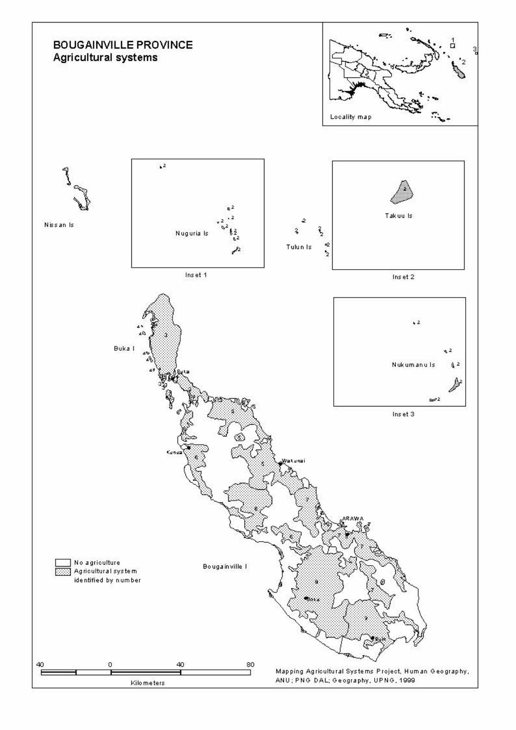
40
BOUGAINVILLE PROVINCE Agricultural systems
Nissan Is
•• Buka I
c::::J No agriculture l::::::::::J Ag ricultur a I system
identified by number
0
Kilometers
N ug uria Is
Ins et 1
Bo uga in ville I
40 80
Tulun Is .. .,
Locality map
••
Takuu Is
Inset 2
~. ........
Nukumanu Is
Inset 3
Map ping Agricultural Systems Project, Hum an Geo gr ap hy, ANU; PNG DAL: Geography, UPNG, 1999
3

BOUGAINVILLE PROVINCE
40 0 40 80
Kilometers
' • •
Fallow vegetation
r:mmm1 Short woody re growth
"""""' ~ Tall woody re growth
[·=-=-=-=-] No Ion g fallow
System 2 (diagramatic)
Map ping Agricultural Systems Project, Hum an Geo gr ap hy, ANU: PNG DAL; Geography. UPNG. 1999

BOUGAINVILLE PROVINCE
• ..
40 0 40
Kilometers
80
• • •
Long fallow period
I::::: I No Ion g fallow ~ 1 to 4years EZ!Z!3 5 to 15 years
System 2 (diagramatic)
Map ping Agricultural Systems Project, Hum an Geo gr ap hy, ANU; PNG DAL: Geography, UPNG, 1999

BOUGAINVILLE PROVINCE
•
40E:::=::=:i::::====~o============40:i::::==========jso Kilometers
Numb er of plantings before fallow
lmmmnl 1 planting only ~ 3 to 5 plantings ~ More th an 40 plantings
•
• •
System 2 (diagramatic)
Map ping Agricultural Systems Project, Hum an Geo gr ap hy, ANU; PNG DAL: Geography, UPNG, 1999

BOUGAINVILLE PROVINCE
..
40E:=:=:=i:::::::]o=:=:=:=:=:=:=340[:::::::::::::::::so Kilometers
' • •
Intensity of land use Ratio of cropping period to fallow period
~Very low l!mmml Low E~5~5i High
System 2 (diagramatic)
@ , .
Map ping Agricultural Systems Project, Hum an Geo gr ap hy, ANU; PNG DAL: Geography, UPNG, 1999

BOUGAINVILLE PROVINCE
r;:;:;:;i ' Em E3 lllllllllD l1 .. ~ .. ]
40 0 40
Kilometers
Crop combinations
Most import ant crops Im po rt ant crops Coconut, swamp taro Cass av a, sweet potato Sweet potato Banana, cassava, coconut Sweet potato Banana, Chinese taro, co co nut Sweet potato Banana, coconut Sweet potato Banana, coconut. taro
• ' • •
System 2 (diagramatic)
80 Map ping Agricultural Systems Project, Hum an Geo gr ap hy, ANU; PNG DAL: Geography, UPNG, 1999

BOUGAINVILLE PROVINCE
40E:=:=:=i:::::::]o=:=:=:=:=:=:=340[:::::::::::::::::so Kilometers
' • •
Garden and crop segregation
I:::: :I Nose greg ation ~ Ga rd en segregation
System 2 (diagramatic)
Map ping Agricultural Systems Project, Hum an Geo gr ap hy, ANU; PNG DAL: Geography, UPNG, 1999

BOUGAINVILLE PROVINCE
• •
40 0 40 80
Kilometers
• • • •
Soil fertility mainten a nee
I:::: :I Long fallow on tv 8 Mulch
System 2 (diagramatic)
Map ping Agricultural Systems Project, Hum an Geo gr ap hy, ANU; PNG DAL: Geography, UPNG, 1999

BOUGAINVILLE PROVINCE
•
40 0 40 80
Kilometers
Soil tillage
1:::::1 None
• • •
• •
System 2 (diagramatic)
Map ping Agricultural Systems Project, Hum an Geo gr ap hy, ANU; PNG DAL: Geography, UPNG, 1999

BOUGAINVILLE PROVINCE
40E:=:=:=i:::::::10=============340C::::::::::::::::::80 Kilometers
. ' • •
Fallow clearing practices f:::::I Fallow cut and not burnt E3 Fallow cut and burnt
System 2 (diagramatic)
Map ping Agricultural Systems Project, Hum an Geo gr ap hy, ANU; PNG DAL: Geography, UPNG, 1999

BOUGAINVILLE PROVINCE
40 0 40 80
Kilometers
Soil mounds and beds I:::: :I Mounds and beds absent ~ Sm all mounds present and beds absent
' • •
System 2 (diagramatic)
Map ping Agricultural Systems Project, Hum an Geo gr ap hy, ANU; PNG DAL: Geography, UPNG, 1999

BOUGAINVILLE PROVINCE
40E:::=::=:i::::====jo::=::=::=::=::=::=40:i::::==========~so Kilometers
Water man ag em ent techniques
~ Now ate r control
• ' • •
System 2 (diagramatic)
Map ping Agricultural Systems Project, Hum an Geo gr ap hy, ANU; PNG DAL: Geography, UPNG, 1999

BOUGAINVILLE PROVINCE
40E:=:=:=i:::::::]o=:=:=:=:=:=:=340[:::::::::::::::::so Kilometers
. ' • •
Cash income activities I:::: :I Nos ign ificant cash income
[[[[[) Cocoa ~ Cocoa. co co nut, fresh food t!t!t:J Coconut, fish
System 2 (diagramatic)
Map ping Agricultural Systems Project, Hum an Geo gr ap hy, ANU; PNG DAL: Geography, UPNG, 1999
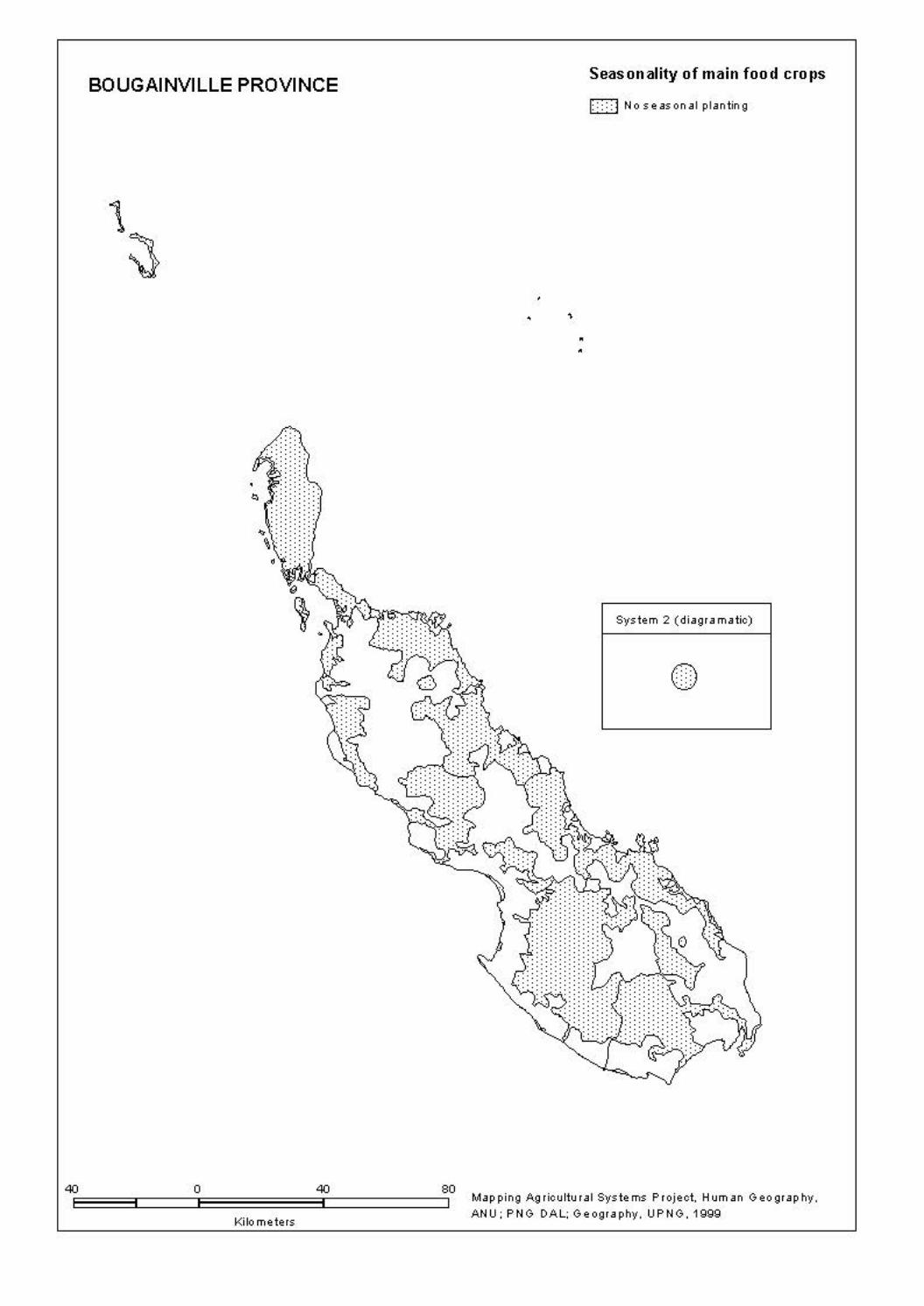
BOUGAINVILLE PROVINCE
40E=:=:=::i:::::::::::Jo=:=:=:=:=:=:=340[:::::::::::::::::so
Kilometers
•
• •
Seas on ality of main food crops
I::::: I Nose as on al planting
System 2 (diagramatic)
Map ping Agricultural Systems Project, Hum an Geo gr ap hy, ANU: PNG DAL; Geography. UPNG. 1999
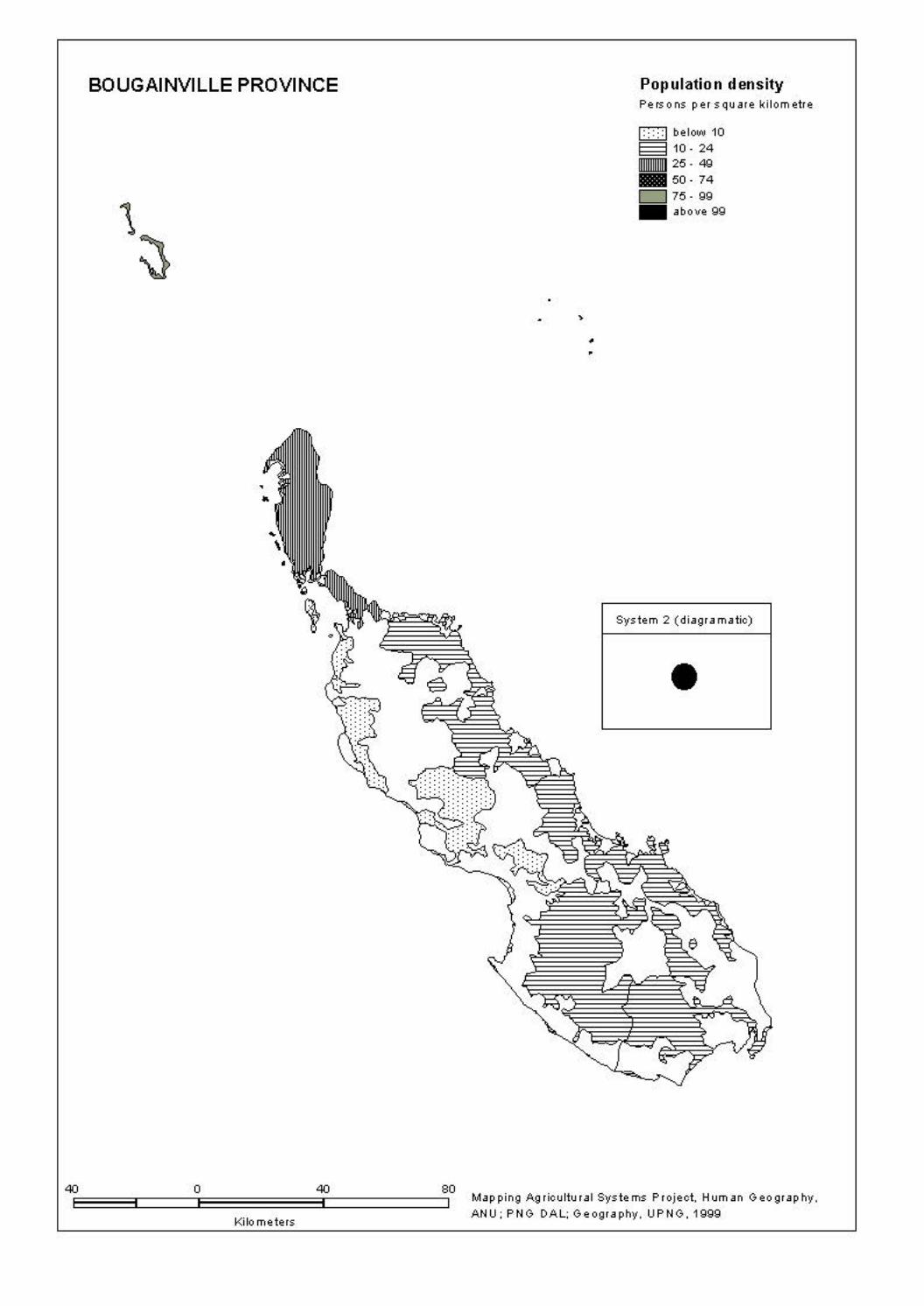
BOUGAINVILLE PROVINCE
40 0 40 80
Kilometers
,
• •
Population density Pe rs o ns per square kilometre
1:::::1below10 § 10· 24 -25-49 -50- 74 c:::J 75. gg .. above 99
System 2 (diagramatic)
•
Map ping Agricultural Systems Project, Hum an Geo gr ap hy, ANU: PNG DAL; Geography. UPNG. 1999

BOUGAINVILLE PROVINCE
40 0 40 80
Kilometers
• • '
• •
Population absent Percentage
System 2 (diagramatic)
Map ping Agricultural Systems Project, Hum an Geo gr ap hy, ANU: PNG DAL; Geography. UPNG. 1999

73
5. AGRICULTURAL SYSTEMS: DATA LISTING BY CODES The following tables list all of the information contained within the database in coded form. The codes are contained in Section 2, Database Structure, Definitions and Codes.

74

AGRICULTURAL SYSTEM DATA LISTING - CODES Province: 20 Bougainville
System Sub No. of Subsys Same sys Districts Census Divisions sys subsys extent oth prov
KEY Subsys Subsystem Same sys Same system in oth prov other province
75
2001 1 1 4 1 01 2002 1 1 4 1 01 2003 1 1 4 1 02-03-04 2004 1 1 4 1 03 2005 1 1 4 1-3 06-16 2006 1 1 4 1-2 05-07 2007 1 1 4 3 13-14-15 2008 1 1 4 2 07-08-09-10 2009 1 1 4 2 11-12

AGRICULTURAL SYSTEM DATA LISTING - CODES Province: 20 Bougainville
System Sub Area Population Altitude range m Slope Fallows sys km2 Total Abs Den Low High Veg Sht Per
KEY Subsys Subsystem Area km2 Area of System Population Fallows Total Resident population 1980 Veg Type of Fallow vegetation Abs Absent population (%) Sht Short fallows Den Population density (persons/km2) Per Long fallow period
76
2001 1 38 2991 13 79 0 20 2 4 0 1 2002 1 16 1607 26 100 0 3 1 7 1 0 2003 1 678 17739 18 26 0 80 1 5 0 2 2004 1 6 1423 35 237 0 20 1 4 1 1 2005 1 846 12500 4 15 0 700 5 5 0 2 2006 1 849 7834 8 9 0 500 5 5 0 2 2007 1 858 16557 5 19 0 1100 3 5 0 2 2008 1 1179 23122 4 20 0 950 2 5 0 2 2009 1 574 13528 5 24 0 800 5 4 0 1

AGRICULTURAL SYSTEM DATA LISTING - CODES Province: 20 Bougainville
System Sub Staple crops Narcotic sys Most import Important Present crops
KEY Subsys Subsystem
77
2001 1 11 02-06-13 02-04-05-06-11-12-13-14-15 2-4-5 2002 1 06-10 04-11 02-04-05-06-10-11-12-13 2003 1 11 02-06-13 02-04-05-06-11-13 2-4-5 2004 1 11 02-04-06 02-04-05-06-11-13 2-4 2005 1 11 02-06-13 02-04-05-06-11-13 2-4-5 2006 1 11 02-04-06 02-04-05-06-11-13-14 2-4-5 2007 1 11 02-05-06 02-05-06-11-13-14 2-4-5 2008 1 11 02-06 02-04-05-06-09-11-13-14-17 2-4-5 2009 1 11 02-05-06 02-05-06-11-13-14-17 2-4-5

AGRICULTURAL SYSTEM DATA LISTING - CODES Province: 20 Bougainville
System Sub Vegetable crops Fruit crops Nut crops sys
KEY Subsys Subsystem
78
2001 1 01-07-09-15-21-24-27 03-04-07-12-15-16-23-35 01-06-07-12-15 2002 1 01-21-24-27-30-32 03-04-05-12-15 01-07-12-15 2003 1 01-08-09-11-15-16-21-23-27-32 03-05-07-12-15-17-23 01-06-12 2004 1 01-08-09-11-15-16-19-21-32 03-05-06-07-12-15-17 01-06-07-12 2005 1 01-09-10-11-15-16-21-23-30-32 05-07-09-12-13-15-17-23 01-06-12 2006 1 01-08-09-10-11-15-16-21-27-32 05-06-07-09-12-15-17-23 01-06-12 2007 1 01-08-09-10-11-15-16-21-31 05-06-07-09-12-15-17-23 01-06-12 2008 1 01-08-09-10-11-15-16-21-23-27 05-07-12-13-15-17-23 01-06-12 2009 1 01-08-09-10-11-15-16-19-21-23 05-07-12-13-15-17-20-23 01-06-12

AGRICULTURAL SYSTEM DATA LISTING - CODES Province: 20 Bougainville
System Sub Segregation Crop Gard types Soil fertility maintenance techniques Sys Gar Crp Seq Mix H’ld Leg Tre Com Man Isl Sil Fer
KEY Subsys Subsystem Segregation Soil fertility maintenance techniques Gar Garden Leg Legume rotation Crp Crop Tre Planted tree fallow Com Compost Crop seq Crop sequences Man Animal manure Isl Island bed Gard types Garden types Sil Silt from floods Mix Mixed vegetable gardens Fer Inorganic fertilizer H'ld Household gardens
79
2001 1 2 1 0 0 2 0 0 0 0 0 0 0 2002 1 3 1 1 0 2 0 0 0 0 0 0 0 2003 1 2 1 0 0 0 0 0 0 0 0 0 0 2004 1 0 1 1 0 1 0 0 0 0 0 0 0 2005 1 1 1 1 0 0 0 0 0 0 0 0 0 2006 1 1 1 1 0 0 0 0 0 0 0 0 0 2007 1 1 1 0 0 0 0 0 0 0 0 0 0 2008 1 0 1 0 0 0 0 0 0 0 0 0 0 2009 1 0 1 1 0 0 0 0 0 0 0 0 0
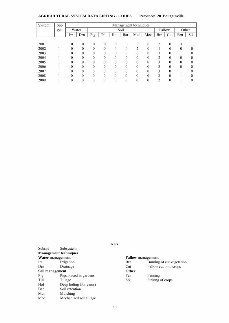
AGRICULTURAL SYSTEM DATA LISTING - CODES Province: 20 Bougainville System Sub Management techniques sys Water Soil Fallow Other Irr Drn Pig Till Hol Bar Mul Mec Brn Cut Fen Stk
KEY Subsys Subsystem Management techniques Water management Fallow management Irr Irrigation Brn Burning of cut vegetation Drn Drainage Cut Fallow cut onto crops Soil management Other Pig Pigs placed in gardens Fen Fencing Till Tillage Stk Staking of crops Hol Deep holing (for yams) Bar Soil retention Mul Mulching Mec Mechanized soil tillage
80
2001 1 0 0 0 0 0 0 0 0 2 0 3 1 2002 1 0 0 0 0 0 0 2 0 1 0 0 0 2003 1 0 0 0 0 0 0 0 0 3 0 1 0 2004 1 0 0 0 0 0 0 0 0 2 0 0 0 2005 1 0 0 0 0 0 0 0 0 3 0 0 0 2006 1 0 0 0 0 0 0 0 0 3 0 0 0 2007 1 0 0 0 0 0 0 0 0 3 0 1 0 2008 1 0 0 0 0 0 0 0 0 3 0 1 0 2009 1 0 0 0 0 0 0 0 0 2 0 1 0

AGRICULTURAL SYSTEM DATA LISTING - CODES Province: 20 Bougainville
System Sub Management techniques Crop planting Cropping R value sys Soil mounds Garden beds seasonality intensity Vsm Sm Md Lge Sq Lg Maj Min
KEY Subsys Subsystem Management techniques Soil mounds Garden beds Vsm Very small Sq Square Sm Small Lg Long Md Medium Crop planting seasonality Lge Large Maj Dominant Min Other crops
81
2001 1 2 0 0 0 0 0 1 1 1 25 2002 1 0 2 0 0 0 0 0 0 6 100 2003 1 0 3 0 0 0 0 0 0 3 29 2004 1 0 3 0 0 0 0 0 0 3 57 2005 1 0 3 0 0 0 0 0 1 3 29 2006 1 0 3 0 0 0 0 0 0 3 29 2007 1 2 1 0 0 0 0 0 0 1 9 2008 1 1 3 0 0 0 0 1 1 3 29 2009 1 0 2 0 0 0 0 0 0 1 25

AGRICULTURAL SYSTEM DATA LISTING - CODES Province: 20 Bougainville
System Sub Cash income sources sys An Bet Crd Cat Chi Coc Cnt CfA CfR Crc Fwd Fsh
KEY Subsys Subsystem Cash Income Sources An Animal skins Chi Chillie CfR Coffee Robusta Bet Betel nut Coc Cocoa Crc Crocodile Crd Cardamom Cnt Coconut Fwd Firewood Cat Cattle CfA Coffee Arabica Fsh Fish
82
2001 1 0 0 0 0 0 0 1 0 0 0 0 2 2002 1 0 0 0 0 0 0 1 0 0 0 0 1 2003 1 0 1 0 0 0 2 3 0 0 0 0 0 2004 1 0 0 0 0 0 0 3 0 0 0 0 2 2005 1 0 1 0 0 0 3 1 0 0 0 0 1 2006 1 0 1 0 0 0 2 1 0 0 0 0 1 2007 1 0 0 0 0 0 2 0 0 0 0 0 0 2008 1 0 0 0 0 0 2 0 0 0 0 0 0 2009 1 0 0 0 0 0 2 0 0 0 0 0 0

AGRICULTURAL SYSTEM DATA LISTING - CODES Province: 20 Bougainville
System Sub Cash income sources sys Fod Op Pot Pyr Ric Rub Shp Tea Tob Ot1 Ot2
KEY Subsys Subsystem Cash Income Sources Fod Fresh food Ric Rice Tob Tobacco Op Oil Palm Rub Rubber Ot1 Other 1 Pot Potato Shp Sheep Ot2 Other 2 Pyr Pyrethrum Tea Tea
83
2001 1 0 0 0 0 0 0 0 0 0 0 0 2002 1 0 0 0 0 0 0 0 0 0 0 0 2003 1 2 0 0 0 0 0 0 0 0 0 0 2004 1 0 0 0 0 0 0 0 0 0 0 0 2005 1 1 0 0 0 0 0 0 0 0 0 0 2006 1 1 0 0 0 0 0 0 0 0 0 0 2007 1 1 0 0 0 0 0 0 0 0 0 0 2008 1 1 0 0 0 0 0 0 0 0 1 0 2009 1 1 0 0 0 0 0 0 0 0 1 0

AGRICULTURAL SYSTEM DATA LISTING - CODES Province: 20 Bougainville
System Sub Survey 1 Survey 2 Survey 3 sys Date Period Sv Sv Date Period Sv Sv Date Period Sv Sv mth yr yrs tp in mth yr yrs tp in mth yr yrs tp in
KEY Subsys Subsystem H/W W. Humphrey/M. Woruba Sv tp Survey type MW M. Woruba Sv in Surveyor initials RMB R.M. Bourke
84
2001 1 09 92 - 3 H/W - - - - - - - - 2002 1 09 92 - 2 MW 01 92 - - MW - - - - 2003 1 06 96 - - RMB - - - - - - - - 2004 1 09 96 - - RMB - - - - - - - - 2005 1 12 80 - 2 RMB 08 96 - - RMB - - - - 2006 1 10 96 - - RMB - - - - - - - - 2007 1 12 80 - 2 RMB 08 96 - - RMB - - - - 2008 1 06 96 - - RMB - - - - - - - - 2009 1 08 96 - - RMB - - - - - - - -

85
6. LISTINGS OF RURAL VILLAGES (CENSUS UNITS) INDEXED TO AGRICULTURAL SYSTEMS
All rural village Census Units in the 1980 National Population Census which are locatable on either the 1980 or 1990 Census Maps are assigned to an Agricultural System. The village name, National Population Census identification codes (Province, District, Census Division, Census Unit), population and Agricultural System number for each village is held as a single record in a population database (AGPOP). District and Census Division codes for this Province are listed in Appendix A.2. This section provides three different listings from that database of rural villages indexed by Agricultural Systems: 6.1 Rural villages listed in census order (District, Census Division). 6.2 Rural villages listed in alphabetical order. 6.3 Rural villages listed by Agricultural System number (alphabetically within agricultural systems) with PNGRIS Resource Mapping Unit (RMU) numbers. Abbreviations used are:
Dist District name and number (see Appendix A.2) Div Census Division number (see Appendix A.2) Population 1980 National Population Census count of population in a Unit RMU Provincial Resource Mapping Unit number (PNGRIS) System Agricultural System number Village Census Unit name Unit Census Unit number

86

6.1 RURAL VILLAGES WITH AGRICULTURAL SYSTEM NUMBERS IN CENSUS ORDER
Province: 20 Bougainville
Village Population System Village Population System
87
DISTRICT 1 Buka
Division 1 Islands
1 AMOTU 241 2002
2 BALIL 335 2001
3 IANGAIN 121 2002
4 IESILA 86 2002
5 ILOSA 64 2002
6 IOLOHANAN 348 2002
7 KULIS 113 2001
8 LIHON 234 2001
9 MAPIRI 308 2001
10 MONTONIA 198 2001
11 NUGURIA 240 2002
12 NUKUTOA 507 2002
13 PIUL 143 2003
14 PORIWON 159 2001
15 ROGOS 124 2001
16 SALEPEN 128 2001
17 SIAKEN 128 2001
18 SIAR 136 2001
19 SIROT 69 2001
20 TANAHERAN 131 2001
21 TANAMALIT 205 2001
22 TARONGAL 157 2001
23 TEAH 199 2001
24 TERAUTUP 184 2001
25 YOTCHIBOL 183 2001
Division 2 Haku-Halia
1 ELUTUPAN 446 2003
2 HAGUS 326 2003
3 HAHALIS 677 2003
4 HANAHAN 642 2003
5 HANPAN 179 2003
6 IELELINA 321 2003
7 KETSKETS 338 2003
8 KOTOPAN 283 2003
9 LEMANKOA 1096 2003
10 LEMANMANU 869 2003
11 LONTIS 941 2003
12 TANDEKI 373 2003
13 TOHATSI 406 2003
Division 3 Punen
1 BARIKUA 337 2003
2 BEI 257 2003
3 BEIKUT 334 2003
4 GAGAN 585 2003
5 HAPAN 359 2003
6 HITAU 90 2004
7 KAHULE 162 2003
8 KOHINO 265 2003
9 KOHISO 410 2003
10 MATSUNGAN 214 2004
11 NOPAN 201 2003
12 NOVAH 335 2003
13 PETATS 588 2004
14 POKA 173 2003
15 PORORAN 357 2004
16 SAPANI 151 2003
17 TELATU 188 2003
18 TUNG 178 2003
19 YAPARU 174 2004
20 YEGITS 196 2003
Division 4 Buka Passage
1 ANAKEI 135 2003
2 CHUNDAWAN 152 2003
3 GOGOHEI NO.1 322 2003
4 GOGOHEI NO.2 266 2003
5 GOHI 238 2003
6 HANGAN 230 2003
7 IETA 368 2003
8 KATSUNKOVERI 174 2003
9 LONAHAN 670 2003
10 MALASANG 886 2003
11 MANOB 231 2003
12 PORAPORA 61 2003
13 RAMUNDATA 100 2003
14 RATSUA 72 2003
15 RURI 192 2003
16 SIARA 244 2003
17 SING 537 2003
18 SOROM 156 2003
19 SUHIN 215 2003
20 TAHAITAHAI 608 2003
21 TAPSANWARA 215 2003
22 TARBUT 289 2003
23 TOROTEI 149 2003
24 UMUM 58 2003
Division 5 Konua
1 AKOPAI 271 2006
2 AMUM 92 2006
3 ASTAPAI 212 2006
4 ATSILIMA 217 2006
5 AUKEI 127 2006
6 BETERAIO 269 2006
7 BOBOASI 54 2006
8 GOTON 94 2006
9 KAKAPARA 140 2006
10 KARARITU 73 2006
11 KAUBATEI 165 2006
12 KAUNA 332 2006
13 KAVIKI 249 2006
14 KEPUI 102 2006
15 KIAKARA 111 2006
16 KOATOROI 88 2006
17 KOPAI 123 2006
18 KOREPOVI 213 2006
19 KOSIPAI 79 2006
20 KUNAPOPO 114 2006
21 KUNOKOMOK 160 2006
22 KURUR 56 2006
23 LALUM 98 2006
24 LONKOGARI 96 2006
25 MAPISI 136 2006
26 MATITSORA 49 2006
27 MOSILAIE 68 2006
28 NAMBAROSI 89 2006

6.1 RURAL VILLAGES WITH AGRICULTURAL SYSTEM NUMBERS IN CENSUS ORDER
Province: 20 Bougainville
Village Population System Village Population System
88
29 PETSPETS 77 2006
30 POKUITO 87 2006
31 POPOHERAI 133 2006
32 PUTO 92 2006
33 RUKUSSIA 71 2006
34 SAPOSA 381 2006
35 SISIAPAI 173 2006
36 MUIRE 179 2006
37 TAIOF 445 2006
38 TOHEI 185 2006
39 TOSIAVI 109 2006
40 TOTOKI 146 2006
Division 6 Teop
1 ARAVIA 134 2005
2 DEOS 105 2005
3 HANTOBIN 120 2005
4 IAUN NO.1 44 2005
5 IAUN NO.2 151 2005
7 IRUE 90 2005
10 KOTOITA 179 2005
11 KOVANIS 160 2005
12 KUKURINA 91 2005
13 MELELUP 289 2005
14 MUTAHI 288 2005
15 NAMAKERIO 152 2005
16 NAMASIORA 186 2005
17 NAMATOA 320 2005
18 NEBLAHIU 156 2005
19 PATEAVEAVE 235 2005
20 POKAPA NO.1 279 2005
21 POKAPA NO.2 166 2005
22 PUSKOMBU 124 2005
24 RARIE 158 2005
25 ROMSIS 265 2005
26 SUANGU 80 2005
27 SUNVAHORA 282 2005
30 TEABES 52 2005
31 TEANANA 149 2005
32 TENDU 45 2005
33 TEOBUHIN NO.1 202 2005
34 TEOBUHIN NO.2 267 2005
35 TEOP 233 2005
36 TETAKUTS 48 2005
37 TOROBAI 62 2005
38 TOROKOKAPIA 265 2005
39 TSIKOT 75 2005
40 TSISIKO 290 2005
41 TSUNPETS 82 2005
42 TUMURI 110 2005
44 VAINANA 220 2005
45 VAROPA 203 2005
46 VASPOS 173 2005
47 WAUWANGINUVA 162 2005
DISTRICT 2 Buin
Division 7 Bagana
1 AGABAI 131 2008
2 ATANGATO 60 2006
3 BEREREKI 117 2008
4 JABA 148 2008
5 KABANAMI 53 2008
6 KARATO 137 2006
7 KAREKOPA 107 2006
8 KASIPEKE 50 2008
9 KAVAKAKATSU 67 2006
10 KENAIA 197 2006
11 KOIARE 156 2006
12 KORO 293 2008
13 KOROMAKETO 120 2006
14 KOROVI 165 2006
15 KUNIKA 149 2008
16 KUPON 201 2008
17 LABALAM 240 2008
18 LABONAMI 181 2008
19 LARUMA 92 2006
20 MAROWA 160 2006
21 MITSIKORI 91 2006
22 MOKOKOREU 190 2008
23 MOM 38 2006
24 MOMOGANARI 150 2008
25 NARINAI 107 2008
26 PANAM 258 2008
27 PIVA 99 2006
28 POLANAVIA 179 2008
29 RELA 230 2008
30 SIANEKI 203 2008
31 SIKOREWA 154 2008
32 TARUBA 193 2008
33 TSITO 80 2006
34 WARARIU 247 2008
35 WARUWARU 255 2008
36 WIWIARO 128 2008
Division 8 Basina
1 AGAWA 111 2008
2 AUMARI 93 2008
3 BAKORAM NO.1 312 2008
4 BAKORAM NO.2 92 2008
5 BERETEMBA 35 2008
6 BIROI 111 2008
7 BIROS 237 2008
8 BOKU 170 2008
9 KONAWA 34 2008
10 KONGARA 86 2008
11 LARENAI 211 2008
12 LAVORO 123 2008
13 LOPERE 135 2008
14 MABES 129 2008
15 MARIGA 90 2008
16 MASIWAKORE 135 2008
17 MASUNKE 36 2008
18 MATONA 67 2008
19 MAWERE 138 2008
20 MENDAI 169 2008
21 MEWA 137 2008
22 MEWARAKA 30 2008
23 MINGETA 43 2008

6.1 RURAL VILLAGES WITH AGRICULTURAL SYSTEM NUMBERS IN CENSUS ORDER
Province: 20 Bougainville
Village Population System Village Population System
89
24 MOAINO 120 2008
25 MOSIGETA 228 2008
26 MOSINO 202 2008
27 NAIRONA 31 2008
28 NUKUI 134 2008
29 OKARU 307 2008
30 ORORO 205 2008
31 OSIAGE 181 2008
32 OSILADA 64 2008
33 PERE 47 2008
34 PIKEI 280 2008
35 POMARATE 273 2008
36 LORO 325 2008
37 ROMARI 109 2008
38 ROTARE NO.1 115 2008
39 ROTARE NO.2 156 2008
40 SINSIRUAI 75 2008
41 SIPI 190 2008
42 TAGURI 149 2008
43 TAIDORIMA 75 2008
44 TAKEMARI 164 2008
45 WAITAWUNA 124 2008
46 WAKUPA 171 2008
Division 9 Rino
1 AITARA 56 2008
2 AMEO 178 2008
3 ARAI 32 2008
4 DOMONINO 84 2008
5 HARI 190 2008
6 HARI KAKU 52 2008
7 HIRE 191 2008
8 HIRUHIRU 97 2008
9 HORINO 283 2008
10 HUKOHAH 158 2008
11 IRU 90 2008
12 KAKOTOKORI 147 2008
13 KAPARO 270 2008
14 KIMMAKU 94 2008
15 KOROPO 61 2008
16 KOTU 52 2008
17 KUMUKI 124 2008
18 KUPINKU 55 2008
19 LAKEMBA 63 2008
20 MAINOIATA 68 2008
21 MAMAGOTA 84 2008
22 MATUKORI 209 2008
23 MIHERO 134 2008
24 MOIBINEI 70 2008
25 MUWOKU 104 2008
26 NUKUI 94 2008
27 OSOKOLI 81 2008
28 PININAI 140 2008
29 PURIKORI 68 2008
30 RABAULU 179 2008
31 RUUNAI 49 2008
32 SININNAI 62 2008
33 SIRARUHO 80 2008
34 SIROI 176 2008
35 TOHU 79 2008
36 TOIRA 48 2008
37 TOITOI 94 2008
38 TOKUNUTU 133 2008
39 TONNUI 121 2008
40 TONU 91 2008
41 UNUNAI 130 2008
42 USO 118 2008
43 MANNAKE 34 2008
44 RUPUMMO 56 2008
Division 10 Pongo
1 HANONG 78 2008
2 HINO 100 2008
3 IEGU 83 2008
4 KAPANA 121 2008
5 KINIRUI 176 2008
6 KOKUI 184 2008
7 KUHINO 54 2008
8 KUNU 210 2008
9 KUTIN 94 2008
10 LAKU 90 2008
11 MAISUA 97 2008
12 MATERAS 103 2008
13 MOKOLINO.1 88 2008
14 MOKOLINO.2 103 2008
15 MOROKAIMORO 149 2008
16 MORONEI 210 2008
17 MUNU 196 2008
18 MUSIMINOI 232 2008
19 NARONAI 72 2008
20 PANAKE 171 2008
21 ROKUSEI 21 2008
22 RUSEI 366 2008
23 SIKUMONE 72 2008
24 SIKURAI 56 2008
25 SIURUHINO 154 2008
26 TURUGUM 172 2008
Division 11 Rerebere
1 AKU 204 2009
2 BORUPI 102 2009
3 BURUBURUNNO 106 2009
4 IBIRO 96 2009
5 KANNAURO 309 2009
6 KIKIMOGU 189 2009
7 KOGISAGANO 102 2009
8 KOKOPO 239 2009
9 KONIGURU 229 2009
10 KUGUGAI 63 2009
11 KUKUMARU 259 2009
12 KUMIROGU 39 2009
13 LAGUAI 539 2009
14 LEROTU 174 2009
15 LOBIGOU 82 2009
16 LUKARARO 345 2009
17 MARAMUKU 83 2009
18 MATSIOUGU 138 2009
19 MOROU 309 2009
20 MORULA 138 2009

6.1 RURAL VILLAGES WITH AGRICULTURAL SYSTEM NUMBERS IN CENSUS ORDER
Province: 20 Bougainville
Village Population System Village Population System
90
21 MOUAKEI 111 2009
22 NABAKU 237 2009
23 NAKARO 130 2009
24 NAKOREI 174 2009
25 NUMAKEI 124 2009
26 OKOMO 116 2009
27 OMITARO 74 2009
28 OREMUTSI 114 2009
29 PARERONO 177 2009
30 PIARINO 117 2009
31 PIRURUINO 66 2009
32 SIALAU 22 2009
33 SIURU 126 2009
34 TARAPA 131 2008
35 TOGULEGU 26 2009
36 TOKUAKA 14 2009
37 TSIMBO 150 2009
38 TUARAGAI 124 2009
39 TUBARU 192 2009
40 TUBOBISOU 113 2009
41 TUGIOGU N0.1 & 2 369 2009
42 TUGIU 282 2009
43 TURIGAU 158 2009
44 UBANMOIUTO 143 2009
Division 12 Porobere
1 BOGISAGO 237 2009
2 BOTULAI 114 2007
3 IAMARU 104 2009
4 IPILAI 224 2009
5 IULA NO.1 189 2009
6 IULA NO.2 165 2009
7 IULA NO.3 99 2009
8 KAITU 133 2009
9 KAMOURO 270 2009
10 KEKEMONO 141 2007
11 KIKIBATSIOGU 98 2009
12 KOGU 95 2009
13 KOGUIKIRU 111 2009
14 KOMAI 32 2009
15 KOUKOUSINO 95 2007
16 KUGUIOGU 144 2009
17 KUKUMAI 150 2009
18 LAITARO 349 2009
19 LAKOVE 136 2009
20 LAMUAI 70 2009
21 LUAGUO 170 2009
22 LUILAU 134 2009
23 LUKAUKO 179 2009
24 MAIKA 136 2009
25 MALABITA 277 2009
26 MAMAROMINO NO.1 170 2009
27 MAMAROMINO NO.2 179 2009
28 MITUAI 87 2009
29 MOGOROI 188 2009
30 MORIU 95 2009
31 MUGUAI 184 2009
32 MUISURU 107 2009
33 NKUMU 50 2009
34 OKOIRAGU 126 2009
35 ORAVA 66 2009
36 OREMAI 307 2007
37 ORIA 182 2007
38 OROROI 112 2009
39 ORUMOI 82 2009
40 PAGUI 228 2007
41 PARERO 86 2009
42 PARIRO 455 2009
43 PAULOUKU 100 2009
44 PIRIRARO 123 2009
45 SADI 53 2009
46 SIUL 118 2009
47 SIURAI 116 2007
48 SULUKUNU 198 2007
49 TABAGO 127 2009
50 TAGURUAI 115 2009
51 TANTAREKI 233 2009
52 TUBARO 115 2009
53 TURUTAI 75 2009
54 UGUPAKOGU 76 2009
DISTRICT 3 Kieta
Division 13 Koromira-Kongara
1 AMAPONG 187 2007
2 AURUI 152 2007
3 BAKAKANI 156 2007
4 BANEI 181 2007
5 DAMBEWEI 51 2007
6 DAMAOSI 69 2008
7 DAMUNA 93 2007
8 DAMUNG 173 2008
9 DONGETA 222 2007
10 IORO 98 2007
11 ISINA 180 2007
12 KAMAROVI 151 2007
13 KAPIKAVE 236 2007
14 KARURU 72 2008
15 KEREMONA 150 2007
16 KURAI 207 2007
17 KURITAVE 187 2008
18 MANGONA 106 2007
19 MARILAU 110 2008
20 MARURA 134 2007
21 MINANI 84 2007
22 MORO 123 2008
23 MUAU 196 2008
24 MUNIAS 116 2007
25 NABUIA 64 2007
26 PEIWANA 147 2007
27 PIRENEIU 287 2007
28 PONDONA 68 2007
29 ROMEINA 122 2007
30 SIOROVI 132 2007
31 SIPURU 104 2008
32 SIPUREI 121 2007
33 SIROVAI 133 2008
34 TAKE 113 2007

6.1 RURAL VILLAGES WITH AGRICULTURAL SYSTEM NUMBERS IN CENSUS ORDER
Province: 20 Bougainville
Village Population System Village Population System
91
35 WIDA 100 2007
Division 14 Nasioi-Pirung
1 AMION 123 2007
2 ANGANAI 155 2007
3 ARAWA 231 2007
4 BAIRIMA 120 2007
5 BAKATUNG 195 2007
6 BAKAWORI 106 2007
7 BONAMUNG 155 2007
8 BUNUMANG 114 2007
9 DAITA 85 2007
10 DARUTUE NO.1 207 2007
11 DARUTUE NO.2 279 2007
12 DINGUNA 114 2007
13 DOKOTORO 89 2007
14 DONSIRO 208 2007
15 KARAKUNG 119 2007
16 KARIKIRA 135 2007
17 KOBUAN 79 2007
18 KOKADEI 133 2007
19 KOVENANG 102 2007
20 KUKA 57 2007
21 KUPEI 169 2007
22 MAKENIKO 64 2007
23 MAUANG 171 2007
24 MOINANG 87 2007
25 MONGONTORO 102 2007
26 MORANGISINA 166 2007
27 NASIOI 207 2007
28 PANKAMA 51 2007
29 PARAIANO 142 2007
30 PAVAIRE 166 2007
31 PIDIA 174 2007
32 POKPOK 303 2007
33 POMA 248 2007
34 POMAUA 134 2007
35 ROROVANA NO.1 246 2007
36 ROROVANA NO.2 264 2007
37 RUMBA 291 2007
38 SIAIE 142 2007
39 SIBUNA 112 2007
40 SINKAI 64 2007
41 SIPA 50 2007
42 SIROMBA 117 2007
43 SIROMBANA 106 2007
44 TAULAPELIA 47 2007
45 TAVIDUA 112 2007
46 TOBOROI 141 2007
47 TOPINA 153 2007
48 UNABATO 103 2007
Division 15 Ioro-Eivo
1 ALAKABAU 64 2007
2 ATAMO 413 2007
3 BOIRA 239 2007
4 BORUMAI 198 2007
5 BOVE 225 2007
6 DAPERA 431 2007
7 DARENAI 326 2008
8 DARU 112 2007
9 GUAVA 131 2008
10 IRANG 274 2008
11 KARNIVITU 326 2007
12 KOKOMATE 127 2008
13 KOKORE 396 2008
14 KOPANI 533 2007
15 KOPIKIRI 172 2007
16 KORPEI 420 2007
17 MAINOKI 346 2008
18 MORONI 89 2007
19 MUMURAI 318 2008
20 MUSINAU 235 2008
21 NASIWOIWA 243 2007
22 ONOVI 238 2008
23 ORAMI 333 2008
24 PAKIA 275 2007
25 PANKA 172 2008
26 PIAWORA 166 2008
27 PISINAU 225 2008
28 SIREONDJI 174 2007
29 SIROWAI 172 2007
30 SUIEMA(PAURA) 197 2007
31 TARARA 152 2007
32 VITO 145 2007
Division 16 Rotokas
1 BULISTORO 231 2005
2 IBU 203 2005
3 INUS 112 2005
4 IPARAKA 312 2005
5 KAKARAPAIA 303 2005
6 KOROBORA 244 2005
7 KUSI NO.1 & 2 133 2005
8 MAPEARO 327 2005
9 NUPATORO NO.1 & 2 405 2005
10 OKOBUPAIA 215 2005
11 OSOWAIPA 162 2005
12 OWAIWAIPA 213 2005
13 PIPIAIA 281 2005
14 POKAIA 245 2005
15 RURUVU 246 2005
16 SIRORIPAIA 255 2005
17 SISIVI 310 2006
18 TEARAKA 283 2005
19 TEPEROI 135 2005
20 TOGARAO 458 2005
21 TOKAI 325 2005
22 TURIMA 193 2005
23 TUTUPAIA 318 2005
24 TUVIA 209 2005

92

6.2 RURAL VILLAGES WITH AGRICULTURAL SYSTEM NUMBERS IN ALPHABETICAL ORDER Province: 20 Bougainville
Village Dist Div Unit System Village Dist Div Unit System
93
AGABAI 2 7 1 2008 AGAWA 2 8 1 2008 AITARA 2 9 1 2008 AKOPAI 1 5 1 2006 AKU 2 11 1 2009 ALAKABAU 3 15 1 2007 AMAPONG 3 13 1 2007 AMEO 2 9 2 2008 AMION 3 14 1 2007 AMOTU 1 1 1 2002 AMUM 1 5 2 2006 ANAKEI 1 4 1 2003 ANGANAI 3 14 2 2007 ARAI 2 9 3 2008 ARAVIA 1 6 1 2005 ARAWA 3 14 3 2007 ASTAPAI 1 5 3 2006 ATAMO 3 15 2 2007 ATANGATO 2 7 2 2006 ATSILIMA 1 5 4 2006 AUKEI 1 5 5 2006 AUMARI 2 8 2 2008 AURUI 3 13 2 2007 BAIRIMA 3 14 4 2007 BAKAKANI 3 13 3 2007 BAKATUNG 3 14 5 2007 BAKAWORI 3 14 6 2007 BAKORAM NO.1 2 8 3 2008 BAKORAM NO.2 2 8 4 2008 BALIL 1 1 2 2001 BANEI 3 13 4 2007 BARIKUA 1 3 1 2003 BEI 1 3 2 2003 BEIKUT 1 3 3 2003 BEREREKI 2 7 3 2008 BERETEMBA 2 8 5 2008 BETERAIO 1 5 6 2006 BIROI 2 8 6 2008 BIROS 2 8 7 2008 BOBOASI 1 5 7 2006 BOGISAGO 2 12 1 2009 BOIRA 3 15 3 2007 BOKU 2 8 8 2008 BONAMUNG 3 14 7 2007 BORUMAI 3 15 4 2007 BORUPI 2 11 2 2009 BOTULAI 2 12 2 2007 BOVE 3 15 5 2007 BULISTORO 3 16 1 2005 BUNUMANG 3 14 8 2007 BURUBURUNNO 2 11 3 2009 CHUNDAWAN 1 4 2 2003 DAITA 3 14 9 2007 DAMAOSI 3 13 6 2008 DAMBEWEI 3 13 5 2007
DAMUNA 3 13 7 2007 DAMUNG 3 13 8 2008 DAPERA 3 15 6 2007 DARENAI 3 15 7 2008 DARU 3 15 8 2007 DARUTUE NO.1 3 14 10 2007 DARUTUE NO.2 3 14 11 2007 DEOS 1 6 2 2005 DINGUNA 3 14 12 2007 DOKOTORO 3 14 13 2007 DOMONINO 2 9 4 2008 DONGETA 3 13 9 2007 DONSIRO 3 14 14 2007 ELUTUPAN 1 2 1 2003 GAGAN 1 3 4 2003 GOGOHEI NO.1 1 4 3 2003 GOGOHEI NO.2 1 4 4 2003 GOHI 1 4 5 2003 GOTON 1 5 8 2006 GUAVA 3 15 9 2008 HAGUS 1 2 2 2003 HAHALIS 1 2 3 2003 HANAHAN 1 2 4 2003 HANGAN 1 4 6 2003 HANONG 2 10 1 2008 HANPAN 1 2 5 2003 HANTOBIN 1 6 3 2005 HAPAN 1 3 5 2003 HARI 2 9 5 2008 HARI KAKU 2 9 6 2008 HINO 2 10 2 2008 HIRE 2 9 7 2008 HIRUHIRU 2 9 8 2008 HITAU 1 3 6 2004 HORINO 2 9 9 2008 HUKOHAH 2 9 10 2008 IAMARU 2 12 3 2009 IANGAIN 1 1 3 2002 IAUN NO.1 1 6 4 2005 IAUN NO.2 1 6 5 2005 IBIRO 2 11 4 2009 IBU 3 16 2 2005 IEGU 2 10 3 2008 IELELINA 1 2 6 2003 IESILA 1 1 4 2002 IETA 1 4 7 2003 ILOSA 1 1 5 2002 INUS 3 16 3 2005 IOLOHANAN 1 1 6 2002 IORO 3 13 10 2007 IPARAKA 3 16 4 2005 IPILAI 2 12 4 2009 IRANG 3 15 10 2008 IRU 2 9 11 2008
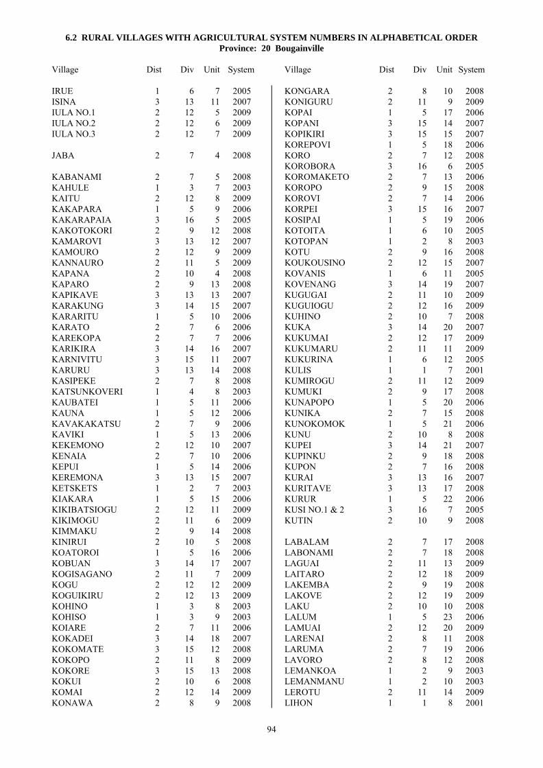
6.2 RURAL VILLAGES WITH AGRICULTURAL SYSTEM NUMBERS IN ALPHABETICAL ORDER Province: 20 Bougainville
Village Dist Div Unit System Village Dist Div Unit System
94
IRUE 1 6 7 2005 ISINA 3 13 11 2007 IULA NO.1 2 12 5 2009 IULA NO.2 2 12 6 2009 IULA NO.3 2 12 7 2009 JABA 2 7 4 2008 KABANAMI 2 7 5 2008 KAHULE 1 3 7 2003 KAITU 2 12 8 2009 KAKAPARA 1 5 9 2006 KAKARAPAIA 3 16 5 2005 KAKOTOKORI 2 9 12 2008 KAMAROVI 3 13 12 2007 KAMOURO 2 12 9 2009 KANNAURO 2 11 5 2009 KAPANA 2 10 4 2008 KAPARO 2 9 13 2008 KAPIKAVE 3 13 13 2007 KARAKUNG 3 14 15 2007 KARARITU 1 5 10 2006 KARATO 2 7 6 2006 KAREKOPA 2 7 7 2006 KARIKIRA 3 14 16 2007 KARNIVITU 3 15 11 2007 KARURU 3 13 14 2008 KASIPEKE 2 7 8 2008 KATSUNKOVERI 1 4 8 2003 KAUBATEI 1 5 11 2006 KAUNA 1 5 12 2006 KAVAKAKATSU 2 7 9 2006 KAVIKI 1 5 13 2006 KEKEMONO 2 12 10 2007 KENAIA 2 7 10 2006 KEPUI 1 5 14 2006 KEREMONA 3 13 15 2007 KETSKETS 1 2 7 2003 KIAKARA 1 5 15 2006 KIKIBATSIOGU 2 12 11 2009 KIKIMOGU 2 11 6 2009 KIMMAKU 2 9 14 2008 KINIRUI 2 10 5 2008 KOATOROI 1 5 16 2006 KOBUAN 3 14 17 2007 KOGISAGANO 2 11 7 2009 KOGU 2 12 12 2009 KOGUIKIRU 2 12 13 2009 KOHINO 1 3 8 2003 KOHISO 1 3 9 2003 KOIARE 2 7 11 2006 KOKADEI 3 14 18 2007 KOKOMATE 3 15 12 2008 KOKOPO 2 11 8 2009 KOKORE 3 15 13 2008 KOKUI 2 10 6 2008 KOMAI 2 12 14 2009 KONAWA 2 8 9 2008
KONGARA 2 8 10 2008 KONIGURU 2 11 9 2009 KOPAI 1 5 17 2006 KOPANI 3 15 14 2007 KOPIKIRI 3 15 15 2007 KOREPOVI 1 5 18 2006 KORO 2 7 12 2008 KOROBORA 3 16 6 2005 KOROMAKETO 2 7 13 2006 KOROPO 2 9 15 2008 KOROVI 2 7 14 2006 KORPEI 3 15 16 2007 KOSIPAI 1 5 19 2006 KOTOITA 1 6 10 2005 KOTOPAN 1 2 8 2003 KOTU 2 9 16 2008 KOUKOUSINO 2 12 15 2007 KOVANIS 1 6 11 2005 KOVENANG 3 14 19 2007 KUGUGAI 2 11 10 2009 KUGUIOGU 2 12 16 2009 KUHINO 2 10 7 2008 KUKA 3 14 20 2007 KUKUMAI 2 12 17 2009 KUKUMARU 2 11 11 2009 KUKURINA 1 6 12 2005 KULIS 1 1 7 2001 KUMIROGU 2 11 12 2009 KUMUKI 2 9 17 2008 KUNAPOPO 1 5 20 2006 KUNIKA 2 7 15 2008 KUNOKOMOK 1 5 21 2006 KUNU 2 10 8 2008 KUPEI 3 14 21 2007 KUPINKU 2 9 18 2008 KUPON 2 7 16 2008 KURAI 3 13 16 2007 KURITAVE 3 13 17 2008 KURUR 1 5 22 2006 KUSI NO.1 & 2 3 16 7 2005 KUTIN 2 10 9 2008 LABALAM 2 7 17 2008 LABONAMI 2 7 18 2008 LAGUAI 2 11 13 2009 LAITARO 2 12 18 2009 LAKEMBA 2 9 19 2008 LAKOVE 2 12 19 2009 LAKU 2 10 10 2008 LALUM 1 5 23 2006 LAMUAI 2 12 20 2009 LARENAI 2 8 11 2008 LARUMA 2 7 19 2006 LAVORO 2 8 12 2008 LEMANKOA 1 2 9 2003 LEMANMANU 1 2 10 2003 LEROTU 2 11 14 2009 LIHON 1 1 8 2001

6.2 RURAL VILLAGES WITH AGRICULTURAL SYSTEM NUMBERS IN ALPHABETICAL ORDER Province: 20 Bougainville
Village Dist Div Unit System Village Dist Div Unit System
95
LOBIGOU 2 11 15 2009 LONAHAN 1 4 9 2003 LONKOGARI 1 5 24 2006 LONTIS 1 2 11 2003 LOPERE 2 8 13 2008 LORO 2 8 36 2008 LUAGUO 2 12 21 2009 LUILAU 2 12 22 2009 LUKARARO 2 11 16 2009 LUKAUKO 2 12 23 2009 MABES 2 8 14 2008 MAIKA 2 12 24 2009 MAINOIATA 2 9 20 2008 MAINOKI 3 15 17 2008 MAISUA 2 10 11 2008 MAKENIKO 3 14 22 2007 MALABITA 2 12 25 2009 MALASANG 1 4 10 2003 MAMAGOTA 2 9 21 2008 MAMAROMINO NO.1 2 12 26 2009 MAMAROMINO NO.2 2 12 27 2009 MANGONA 3 13 18 2007 MANNAKE 2 9 43 2008 MANOB 1 4 11 2003 MAPEARO 3 16 8 2005 MAPIRI 1 1 9 2001 MAPISI 1 5 25 2006 MARAMUKU 2 11 17 2009 MARIGA 2 8 15 2008 MARILAU 3 13 19 2008 MAROWA 2 7 20 2006 MARURA 3 13 20 2007 MASIWAKORE 2 8 16 2008 MASUNKE 2 8 17 2008 MATERAS 2 10 12 2008 MATITSORA 1 5 26 2006 MATONA 2 8 18 2008 MATSIOUGU 2 11 18 2009 MATSUNGAN 1 3 10 2004 MATUKORI 2 9 22 2008 MAUANG 3 14 23 2007 MAWERE 2 8 19 2008 MELELUP 1 6 13 2005 MENDAI 2 8 20 2008 MEWA 2 8 21 2008 MEWARAKA 2 8 22 2008 MIHERO 2 9 23 2008 MINANI 3 13 21 2007 MINGETA 2 8 23 2008 MITSIKORI 2 7 21 2006 MITUAI 2 12 28 2009 MOAINO 2 8 24 2008 MOGOROI 2 12 29 2009 MOIBINEI 2 9 24 2008 MOINANG 3 14 24 2007 MOKOKOREU 2 7 22 2008 MOKOLI NO.1 2 10 13 2008
MOKOLI NO.2 2 10 14 2008 MOM 2 7 23 2006 MOMOGANARI 2 7 24 2008 MONGONTORO 3 14 25 2007 MONTONIA 1 1 10 2001 MORANGISINA 3 14 26 2007 MORIU 2 12 30 2009 MORO 3 13 22 2008 MOROKAIMORO 2 10 15 2008 MORONEI 2 10 16 2008 MORONI 3 15 18 2007 MOROU 2 11 19 2009 MORULA 2 11 20 2009 MOSIGETA 2 8 25 2008 MOSILAIE 1 5 27 2006 MOSINO 2 8 26 2008 MOUAKEI 2 11 21 2009 MUAU 3 13 23 2008 MUGUAI 2 12 31 2009 MUIRE 1 5 36 2006 MUISURU 2 12 32 2009 MUMURAI 3 15 19 2008 MUNIAS 3 13 24 2007 MUNU 2 10 17 2008 MUSIMINOI 2 10 18 2008 MUSINAU 3 15 20 2008 MUTAHI 1 6 14 2005 MUWOKU 2 9 25 2008 NABAKU 2 11 22 2009 NABUIA 3 13 25 2007 NAIRONA 2 8 27 2008 NAKARO 2 11 23 2009 NAKOREI 2 11 24 2009 NAMAKERIO 1 6 15 2005 NAMASIORA 1 6 16 2005 NAMATOA 1 6 17 2005 NAMBAROSI 1 5 28 2006 NARINAI 2 7 25 2008 NARONAI 2 10 19 2008 NASIOI 3 14 27 2007 NASIWOIWA 3 15 21 2007 NEBLAHIU 1 6 18 2005 NKUMU 2 12 33 2009 NOPAN 1 3 11 2003 NOVAH 1 3 12 2003 NUGURIA 1 1 11 2002 NUKUI 2 8 28 2008 NUKUI 2 9 26 2008 NUKUTOA 1 1 12 2002 NUMAKEI 2 11 25 2009 NUPATORO NO.1 & 2 3 16 9 2005 OKARU 2 8 29 2008 OKOBUPAIA 3 16 10 2005 OKOIRAGU 2 12 34 2009 OKOMO 2 11 26 2009 OMITARO 2 11 27 2009

6.2 RURAL VILLAGES WITH AGRICULTURAL SYSTEM NUMBERS IN ALPHABETICAL ORDER Province: 20 Bougainville
Village Dist Div Unit System Village Dist Div Unit System
96
ONOVI 3 15 22 2008 ORAMI 3 15 23 2008 ORAVA 2 12 35 2009 OREMAI 2 12 36 2007 OREMUTSI 2 11 28 2009 ORIA 2 12 37 2007 ORORO 2 8 30 2008 OROROI 2 12 38 2009 ORUMOI 2 12 39 2009 OSIAGE 2 8 31 2008 OSILADA 2 8 32 2008 OSOKOLI 2 9 27 2008 OSOWAIPA 3 16 11 2005 OWAIWAIPA 3 16 12 2005 PAGUI 2 12 40 2007 PAKIA 3 15 24 2007 PANAKE 2 10 20 2008 PANAM 2 7 26 2008 PANKA 3 15 25 2008 PANKAMA 3 14 28 2007 PARAIANO 3 14 29 2007 PARERO 2 12 41 2009 PARERONO 2 11 29 2009 PARIRO 2 12 42 2009 PATEAVEAVE 1 6 19 2005 PAULOUKU 2 12 43 2009 PAVAIRE 3 14 30 2007 PEIWANA 3 13 26 2007 PERE 2 8 33 2008 PETATS 1 3 13 2004 PETSPETS 1 5 29 2006 PIARINO 2 11 30 2009 PIAWORA 3 15 26 2008 PIDIA 3 14 31 2007 PIKEI 2 8 34 2008 PININAI 2 9 28 2008 PIPIAIA 3 16 13 2005 PIRENEIU 3 13 27 2007 PIRIRARO 2 12 44 2009 PIRURUINO 2 11 31 2009 PISINAU 3 15 27 2008 PIUL 1 1 13 2003 PIVA 2 7 27 2006 POKA 1 3 14 2003 POKAIA 3 16 14 2005 POKAPA NO.1 1 6 20 2005 POKAPA NO.2 1 6 21 2005 POKPOK 3 14 32 2007 POKUITO 1 5 30 2006 POLANAVIA 2 7 28 2008 POMA 3 14 33 2007 POMARATE 2 8 35 2008 POMAUA 3 14 34 2007 PONDONA 3 13 28 2007 POPOHERAI 1 5 31 2006 PORAPORA 1 4 12 2003 PORIWON 1 1 14 2001
PORORAN 1 3 15 2004 PURIKORI 2 9 29 2008 PUSKOMBU 1 6 22 2005 PUTO 1 5 32 2006 RABAULU 2 9 30 2008 RAMUNDATA 1 4 13 2003 RARIE 1 6 24 2005 RATSUA 1 4 14 2003 RELA 2 7 29 2008 ROGOS 1 1 15 2001 ROKUSEI 2 10 21 2008 ROMARI 2 8 37 2008 ROMEINA 3 13 29 2007 ROMSIS 1 6 25 2005 ROROVANA NO.1 3 14 35 2007 ROROVANA NO.2 3 14 36 2007 ROTARE NO.1 2 8 38 2008 ROTARE NO.2 2 8 39 2008 RUKUSSIA 1 5 33 2006 RUMBA 3 14 37 2007 RUPUMMO 2 9 44 2008 RURI 1 4 15 2003 RURUVU 3 16 15 2005 RUSEI 2 10 22 2008 RUUNAI 2 9 31 2008 SADI 2 12 45 2009 SALEPEN 1 1 16 2001 SAPANI 1 3 16 2003 SAPOSA 1 5 34 2006 SIAIE 3 14 38 2007 SIAKEN 1 1 17 2001 SIALAU 2 11 32 2009 SIANEKI 2 7 30 2008 SIAR 1 1 18 2001 SIARA 1 4 16 2003 SIBUNA 3 14 39 2007 SIKOREWA 2 7 31 2008 SIKUMONE 2 10 23 2008 SIKURAI 2 10 24 2008 SING 1 4 17 2003 SININNAI 2 9 32 2008 SINKAI 3 14 40 2007 SINSIRUAI 2 8 40 2008 SIOROVI 3 13 30 2007 SIPA 3 14 41 2007 SIPI 2 8 41 2008 SIPUREI 3 13 32 2007 SIPURU 3 13 31 2008 SIRARUHO 2 9 33 2008 SIREONDJI 3 15 28 2007 SIROI 2 9 34 2008 SIROMBA 3 14 42 2007 SIROMBANA 3 14 43 2007 SIRORIPAIA 3 16 16 2005 SIROT 1 1 19 2001 SIROVAI 3 13 33 2008
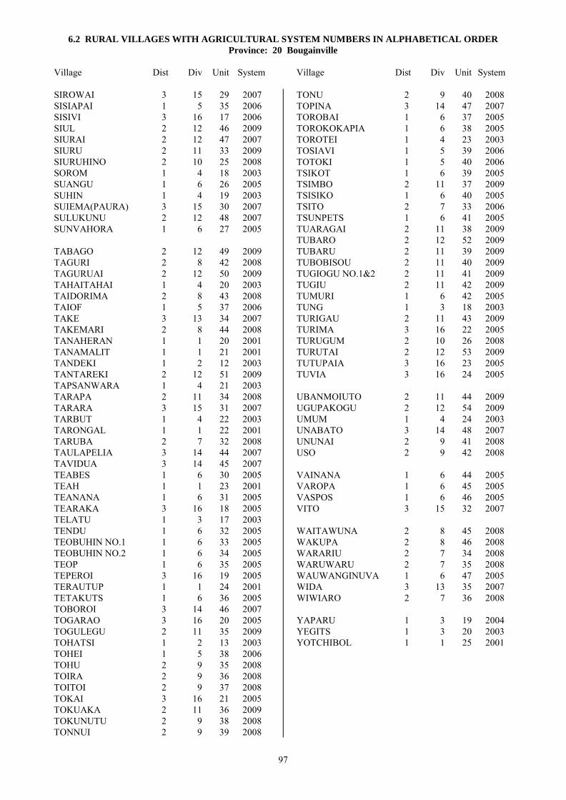
6.2 RURAL VILLAGES WITH AGRICULTURAL SYSTEM NUMBERS IN ALPHABETICAL ORDER Province: 20 Bougainville
Village Dist Div Unit System Village Dist Div Unit System
97
SIROWAI 3 15 29 2007 SISIAPAI 1 5 35 2006 SISIVI 3 16 17 2006 SIUL 2 12 46 2009 SIURAI 2 12 47 2007 SIURU 2 11 33 2009 SIURUHINO 2 10 25 2008 SOROM 1 4 18 2003 SUANGU 1 6 26 2005 SUHIN 1 4 19 2003 SUIEMA(PAURA) 3 15 30 2007 SULUKUNU 2 12 48 2007 SUNVAHORA 1 6 27 2005 TABAGO 2 12 49 2009 TAGURI 2 8 42 2008 TAGURUAI 2 12 50 2009 TAHAITAHAI 1 4 20 2003 TAIDORIMA 2 8 43 2008 TAIOF 1 5 37 2006 TAKE 3 13 34 2007 TAKEMARI 2 8 44 2008 TANAHERAN 1 1 20 2001 TANAMALIT 1 1 21 2001 TANDEKI 1 2 12 2003 TANTAREKI 2 12 51 2009 TAPSANWARA 1 4 21 2003 TARAPA 2 11 34 2008 TARARA 3 15 31 2007 TARBUT 1 4 22 2003 TARONGAL 1 1 22 2001 TARUBA 2 7 32 2008 TAULAPELIA 3 14 44 2007 TAVIDUA 3 14 45 2007 TEABES 1 6 30 2005 TEAH 1 1 23 2001 TEANANA 1 6 31 2005 TEARAKA 3 16 18 2005 TELATU 1 3 17 2003 TENDU 1 6 32 2005 TEOBUHIN NO.1 1 6 33 2005 TEOBUHIN NO.2 1 6 34 2005 TEOP 1 6 35 2005 TEPEROI 3 16 19 2005 TERAUTUP 1 1 24 2001 TETAKUTS 1 6 36 2005 TOBOROI 3 14 46 2007 TOGARAO 3 16 20 2005 TOGULEGU 2 11 35 2009 TOHATSI 1 2 13 2003 TOHEI 1 5 38 2006 TOHU 2 9 35 2008 TOIRA 2 9 36 2008 TOITOI 2 9 37 2008 TOKAI 3 16 21 2005 TOKUAKA 2 11 36 2009 TOKUNUTU 2 9 38 2008 TONNUI 2 9 39 2008
TONU 2 9 40 2008 TOPINA 3 14 47 2007 TOROBAI 1 6 37 2005 TOROKOKAPIA 1 6 38 2005 TOROTEI 1 4 23 2003 TOSIAVI 1 5 39 2006 TOTOKI 1 5 40 2006 TSIKOT 1 6 39 2005 TSIMBO 2 11 37 2009 TSISIKO 1 6 40 2005 TSITO 2 7 33 2006 TSUNPETS 1 6 41 2005 TUARAGAI 2 11 38 2009 TUBARO 2 12 52 2009 TUBARU 2 11 39 2009 TUBOBISOU 2 11 40 2009 TUGIOGU NO.1&2 2 11 41 2009 TUGIU 2 11 42 2009 TUMURI 1 6 42 2005 TUNG 1 3 18 2003 TURIGAU 2 11 43 2009 TURIMA 3 16 22 2005 TURUGUM 2 10 26 2008 TURUTAI 2 12 53 2009 TUTUPAIA 3 16 23 2005 TUVIA 3 16 24 2005 UBANMOIUTO 2 11 44 2009 UGUPAKOGU 2 12 54 2009 UMUM 1 4 24 2003 UNABATO 3 14 48 2007 UNUNAI 2 9 41 2008 USO 2 9 42 2008 VAINANA 1 6 44 2005 VAROPA 1 6 45 2005 VASPOS 1 6 46 2005 VITO 3 15 32 2007 WAITAWUNA 2 8 45 2008 WAKUPA 2 8 46 2008 WARARIU 2 7 34 2008 WARUWARU 2 7 35 2008 WAUWANGINUVA 1 6 47 2005 WIDA 3 13 35 2007 WIWIARO 2 7 36 2008 YAPARU 1 3 19 2004 YEGITS 1 3 20 2003 YOTCHIBOL 1 1 25 2001

98

6.3 RURAL VILLAGES LISTED BY AGRICULTURAL SYSTEM Province: 20 Bougainville
Village Dist Div Unit RMU Village Dist Div Unit RMU
99
SYSTEM 2001
BALIL 1 1 2 2
KULIS 1 1 7 2
LIHON 1 1 8 2
MAPIRI 1 1 9 2
MONTONIA 1 1 10 1
PORIWON 1 1 14 2
ROGOS 1 1 15 1
SALEPEN 1 1 16 2
SIAKEN 1 1 17 2
SIAR 1 1 18 2
SIROT 1 1 19 2
TANAHERAN 1 1 20 2
TANAMALIT 1 1 21 2
TARONGAL 1 1 22 2
TEAH 1 1 23 1
TERAUTUP 1 1 24 2
YOTCHIBOL 1 1 25 2
SYSTEM 2002
AMOTU 1 1 1 137
IANGAIN 1 1 3 129
IESILA 1 1 4 129
ILOSA 1 1 5 129
IOLOHANAN 1 1 6 129
NUGURIA 1 1 11 127
NUKUTOA 1 1 12 128
SYSTEM 2003
ANAKEI 1 4 1 16
BARIKUA 1 3 1 4
BEI 1 3 2 130
BEIKUT 1 3 3 4
CHUNDAWAN 1 4 2 16
ELUTUPAN 1 2 1 3
GAGAN 1 3 4 4
GOGOHEI NO.1 1 4 3 3
GOGOHEI NO.2 1 4 4 3
GOHI 1 4 5 16
HAGUS 1 2 2 3
HAHALIS 1 2 3 3
HANAHAN 1 2 4 3
HANGAN 1 4 6 3
HANPAN 1 2 5 3
HAPAN 1 3 5 4
IELELINA 1 2 6 3
IETA 1 4 7 3
KAHULE 1 3 7 130
KATSUNKOVERI 1 4 8 16
KETSKETS 1 2 7 3
KOHINO 1 3 8 4
KOHISO 1 3 9 4
KOTOPAN 1 2 8 3
LEMANKOA 1 2 9 3
LEMANMANU 1 2 10 3
LONAHAN 1 4 9 3
LONTIS 1 2 11 3
MALASANG 1 4 10 3
MANOB 1 4 11 16
NOPAN 1 3 11 4
NOVAH 1 3 12 8
PIUL 1 1 13 129
POKA 1 3 14 130
PORAPORA 1 4 12 19
RAMUNDATA 1 4 13 16
RATSUA 1 4 14 140
RURI 1 4 15 16
SAPANI 1 3 16 4
SIARA 1 4 16 16
SING 1 4 17 3
SOROM 1 4 18 16
SUHIN 1 4 19 3
TAHAITAHAI 1 4 20 3
TANDEKI 1 2 12 3
TAPSANWARA 1 4 21 16
TARBUT 1 4 22 16
TELATU 1 3 17 3
TOHATSI 1 2 13 3
TOROTEI 1 4 23 16
TUNG 1 3 18 130
UMUM 1 4 24 16
YEGITS 1 3 20 130
SYSTEM 2004
HITAU 1 3 6 126
MATSUNGAN 1 3 10 120
PETATS 1 3 13 120
PORORAN 1 3 15 7
YAPARU 1 3 19 7
SYSTEM 2005
ARAVIA 1 6 1 26
BULISTORO 3 16 1 50
DEOS 1 6 2 21
HANTOBIN 1 6 3 19
IAUN NO.1 1 6 4 23
IAUN NO.2 1 6 5 23
IBU 3 16 2 50
INUS 3 16 3 53
IPARAKA 3 16 4 56
IRUE 1 6 7 141
KAKARAPAIA 3 16 5 50
KOROBORA 3 16 6 51
KOTOITA 1 6 10 52
KOVANIS 1 6 11 22
KUKURINA 1 6 12 19
KUSI NO.1 & 2 3 16 7 25
MAPEARO 3 16 8 57
MELELUP 1 6 13 25
MUTAHI 1 6 14 25
NAMAKERIO 1 6 15 143
NAMASIORA 1 6 16 19
NAMATOA 1 6 17 24
NEBLAHIU 1 6 18 24
NUPATORO NO.1 & 2 3 16 9 51
OKOBUPAIA 3 16 10 68
OSOWAIPA 3 16 11 25
OWAIWAIPA 3 16 12 25

6.3 RURAL VILLAGES LISTED BY AGRICULTURAL SYSTEM Province: 20 Bougainville
Village Dist Div Unit RMU Village Dist Div Unit RMU
100
PATEAVEAVE 1 6 19 24
PIPIAIA 3 16 13 51
POKAIA 3 16 14 50
POKAPA NO.1 1 6 20 19
POKAPA NO.2 1 6 21 19
PUSKOMBU 1 6 22 23
RARIE 1 6 24 25
ROMSIS 1 6 25 19
RURUVU 3 16 15 49
SIRORIPAIA 3 16 16 57
SUANGU 1 6 26 19
SUNVAHORA 1 6 27 23
TEABES 1 6 30 22
TEANANA 1 6 31 23
TEARAKA 3 16 18 54
TENDU 1 6 32 143
TEOBUHIN NO.1 1 6 33 19
TEOBUHIN NO.2 1 6 34 19
TEOP 1 6 35 125
TEPEROI 3 16 19 55
TETAKUTS 1 6 36 19
TOGARAO 3 16 20 49
TOKAI 3 16 21 51
TOROBAI 1 6 37 25
TOROKOKAPIA 1 6 38 19
TSIKOT 1 6 39 143
TSISIKO 1 6 40 19
TSUNPETS 1 6 41 16
TUMURI 1 6 42 24
TURIMA 3 16 22 51
TUTUPAIA 3 16 23 50
TUVIA 3 16 24 24
VAINANA 1 6 44 23
VAROPA 1 6 45 23
VASPOS 1 6 46 25
WAUWANGINUVA 1 6 47 19
SYSTEM 2006
AKOPAI 1 5 1 36
AMUM 1 5 2 34
ASTAPAI 1 5 3 35
ATANGATO 2 7 2 78
ATSILIMA 1 5 4 60
AUKEI 1 5 5 37
BETERAIO 1 5 6 35
BOBOASI 1 5 7 37
GOTON 1 5 8 17
KAKAPARA 1 5 9 17
KARARITU 1 5 10 36
KARATO 2 7 6 78
KAREKOPA 2 7 7 78
KAUBATEI 1 5 11 37
KAUNA 1 5 12 36
KAVAKAKATSU 2 7 9 66
KAVIKI 1 5 13 37
KENAIA 2 7 10 148
KEPUI 1 5 14 29
KIAKARA 1 5 15 33
KOATOROI 1 5 16 29
KOIARE 2 7 11 80
KOPAI 1 5 17 29
KOREPOVI 1 5 18 36
KOROMAKETO 2 7 13 63
KOROVI 2 7 14 78
KOSIPAI 1 5 19 33
KUNAPOPO 1 5 20 17
KUNOKOMOK 1 5 21 29
KURUR 1 5 22 29
LALUM 1 5 23 17
LARUMA 2 7 19 135
LONKOGARI 1 5 24 63
MAPISI 1 5 25 29
MAROWA 2 7 20 80
MATITSORA 1 5 26 17
MITSIKORI 2 7 21 63
MOM 2 7 23 78
MOSILAIE 1 5 27 33
MUIRE 1 5 36 36
NAMBAROSI 1 5 28 17
PETSPETS 1 5 29 29
PIVA 2 7 27 63
POKUITO 1 5 30 60
POPOHERAI 1 5 31 29
PUTO 1 5 32 17
RUKUSSIA 1 5 33 17
SAPOSA 1 5 34 123
SISIAPAI 1 5 35 33
SISIVI 3 16 17 49
TAIOF 1 5 37 11
TOHEI 1 5 38 33
TOSIAVI 1 5 39 29
TOTOKI 1 5 40 29
TSITO 2 7 33 66
SYSTEM 2007
ALAKABAU 3 15 1 72
AMAPONG 3 13 1 76
AMION 3 14 1 76
ANGANAI 3 14 2 76
ARAWA 3 14 3 76
ATAMO 3 15 2 76
AURUI 3 13 2 76
BAIRIMA 3 14 4 76
BAKAKANI 3 13 3 89
BAKATUNG 3 14 5 76
BAKAWORI 3 14 6 145
BANEI 3 13 4 77
BOIRA 3 15 3 76
BONAMUNG 3 14 7 76
BORUMAI 3 15 4 76
BOTULAI 2 12 2 147
BOVE 3 15 5 72
BUNUMANG 3 14 8 76
DAITA 3 14 9 76
DAMBEWEI 3 13 5 77
DAMUNA 3 13 7 76
DAPERA 3 15 6 144
DARU 3 15 8 77

6.3 RURAL VILLAGES LISTED BY AGRICULTURAL SYSTEM Province: 20 Bougainville
Village Dist Div Unit RMU Village Dist Div Unit RMU
101
DARUTUE NO.1 3 14 10 76
DARUTUE NO.2 3 14 11 77
DINGUNA 3 14 12 76
DOKOTORO 3 14 13 76
DONGETA 3 13 9 93
DONSIRO 3 14 14 76
IORO 3 13 10 76
ISINA 3 13 11 76
KAMAROVI 3 13 12 76
KAPIKAVE 3 13 13 139
KARAKUNG 3 14 15 76
KARIKIRA 3 14 16 77
KARNIVITU 3 15 11 76
KEKEMONO 2 12 10 93
KEREMONA 3 13 15 89
KOBUAN 3 14 17 76
KOKADEI 3 14 18 76
KOPANI 3 15 14 69
KOPIKIRI 3 15 15 69
KORPEI 3 15 16 76
KOUKOUSINO 2 12 15 93
KOVENANG 3 14 19 76
KUKA 3 14 20 76
KUPEI 3 14 21 77
KURAI 3 13 16 76
MAKENIKO 3 14 22 76
MANGONA 3 13 18 76
MARURA 3 13 20 139
MAUANG 3 14 23 76
MINANI 3 13 21 76
MOINANG 3 14 24 77
MONGONTORO 3 14 25 76
MORANGISINA 3 14 26 76
MORONI 3 15 18 144
MUNIAS 3 13 24 76
NABUIA 3 13 25 76
NASIOI 3 14 27 77
NASIWOIWA 3 15 21 76
OREMAI 2 12 36 93
ORIA 2 12 37 147
PAGUI 2 12 40 147
PAKIA 3 15 24 76
PANKAMA 3 14 28 76
PARAIANO 3 14 29 95
PAVAIRE 3 14 30 76
PEIWANA 3 13 26 76
PIDIA 3 14 31 138
PIRENEIU 3 13 27 76
POKPOK 3 14 32 96
POMA 3 14 33 76
POMAUA 3 14 34 76
PONDONA 3 13 28 76
ROMEINA 3 13 29 76
ROROVANA NO.1 3 14 35 76
ROROVANA NO.2 3 14 36 76
RUMBA 3 14 37 95
SIAIE 3 14 38 76
SIBUNA 3 14 39 76
SINKAI 3 14 40 76
SIOROVI 3 13 30 76
SIPA 3 14 41 138
SIPUREI 3 13 32 76
SIREONDJI 3 15 28 76
SIROMBA 3 14 42 76
SIROMBANA 3 14 43 76
SIROWAI 3 15 29 78
SIURAI 2 12 47 100
SUIEMA(PAURA) 3 15 30 78
SULUKUNU 2 12 48 147
TAKE 3 13 34 76
TARARA 3 15 31 70
TAULAPELIA 3 14 44 76
TAVIDUA 3 14 45 76
TOBOROI 3 14 46 76
TOPINA 3 14 47 76
UNABATO 3 14 48 77
VITO 3 15 32 72
WIDA 3 13 35 76
SYSTEM 2008
AGABAI 2 7 1 85
AGAWA 2 8 1 85
AITARA 2 9 1 92
AMEO 2 9 2 131
ARAI 2 9 3 131
AUMARI 2 8 2 85
BAKORAM NO.1 2 8 3 85
BAKORAM NO.2 2 8 4 85
BEREREKI 2 7 3 85
BERETEMBA 2 8 5 85
BIROI 2 8 6 85
BIROS 2 8 7 85
BOKU 2 8 8 86
DAMAOSI 3 13 6 94
DAMUNG 3 13 8 94
DARENAI 3 15 7 78
DOMONINO 2 9 4 131
GUAVA 3 15 9 77
HANONG 2 10 1 87
HARI 2 9 5 131
HARI KAKU 2 9 6 131
HINO 2 10 2 131
HIRE 2 9 7 131
HIRUHIRU 2 9 8 131
HORINO 2 9 9 131
HUKOHAH 2 9 10 131
IEGU 2 10 3 87
IRANG 3 15 10 78
IRU 2 9 11 87
JABA 2 7 4 79
KABANAMI 2 7 5 86
KAKOTOKORI 2 9 12 131
KAPANA 2 10 4 131
KAPARO 2 9 13 131
KARURU 3 13 14 77
KASIPEKE 2 7 8 86
KIMMAKU 2 9 14 131
KINIRUI 2 10 5 131

6.3 RURAL VILLAGES LISTED BY AGRICULTURAL SYSTEM Province: 20 Bougainville
Village Dist Div Unit RMU Village Dist Div Unit RMU
102
KOKOMATE 3 15 12 78
KOKORE 3 15 13 77
KOKUI 2 10 6 131
KONAWA 2 8 9 85
KONGARA 2 8 10 85
KORO 2 7 12 78
KOROPO 2 9 15 131
KOTU 2 9 16 131
KUHINO 2 10 7 87
KUMUKI 2 9 17 131
KUNIKA 2 7 15 83
KUNU 2 10 8 131
KUPINKU 2 9 18 131
KUPON 2 7 16 83
KURITAVE 3 13 17 77
KUTIN 2 10 9 131
LABALAM 2 7 17 78
LABONAMI 2 7 18 78
LAKEMBA 2 9 19 131
LAKU 2 10 10 87
LARENAI 2 8 11 85
LAVORO 2 8 12 85
LOPERE 2 8 13 85
LORO 2 8 36 85
MABES 2 8 14 85
MAINOIATA 2 9 20 131
MAINOKI 3 15 17 78
MAISUA 2 10 11 87
MAMAGOTA 2 9 21 118
MANNAKE 2 9 43 131
MARIGA 2 8 15 85
MARILAU 3 13 19 90
MASIWAKORE 2 8 16 85
MASUNKE 2 8 17 82
MATERAS 2 10 12 87
MATONA 2 8 18 85
MATUKORI 2 9 22 131
MAWERE 2 8 19 85
MENDAI 2 8 20 85
MEWA 2 8 21 85
MEWARAKA 2 8 22 79
MIHERO 2 9 23 131
MINGETA 2 8 23 85
MOAINO 2 8 24 87
MOIBINEI 2 9 24 131
MOKOKOREU 2 7 22 85
MOKOLI NO.1 2 10 13 87
MOKOLI NO.2 2 10 14 87
MOMOGANARI 2 7 24 85
MORO 3 13 22 77
MOROKAIMORO 2 10 15 87
MORONEI 2 10 16 87
MOSIGETA 2 8 25 85
MOSINO 2 8 26 85
MUAU 3 13 23 94
MUMURAI 3 15 19 78
MUNU 2 10 17 131
MUSIMINOI 2 10 18 131
MUSINAU 3 15 20 145
MUWOKU 2 9 25 87
NAIRONA 2 8 27 85
NARINAI 2 7 25 85
NARONAI 2 10 19 87
NUKUI 2 8 28 85
NUKUI 2 9 26 131
OKARU 2 8 29 86
ONOVI 3 15 22 78
ORAMI 3 15 23 78
ORORO 2 8 30 85
OSIAGE 2 8 31 85
OSILADA 2 8 32 85
OSOKOLI 2 9 27 131
PANAKE 2 10 20 131
PANAM 2 7 26 86
PANKA 3 15 25 77
PERE 2 8 33 85
PIAWORA 3 15 26 78
PIKEI 2 8 34 85
PININAI 2 9 28 131
PISINAU 3 15 27 78
POLANAVIA 2 7 28 85
POMARATE 2 8 35 85
PURIKORI 2 9 29 131
RABAULU 2 9 30 131
RELA 2 7 29 78
ROKUSEI 2 10 21 131
ROMARI 2 8 37 85
ROTARE NO.1 2 8 38 85
ROTARE NO.2 2 8 39 86
RUPUMMO 2 9 44 131
RUSEI 2 10 22 131
RUUNAI 2 9 31 131
SIANEKI 2 7 30 85
SIKOREWA 2 7 31 78
SIKUMONE 2 10 23 87
SIKURAI 2 10 24 131
SININNAI 2 9 32 131
SINSIRUAI 2 8 40 85
SIPI 2 8 41 85
SIPURU 3 13 31 77
SIRARUHO 2 9 33 131
SIROI 2 9 34 131
SIROVAI 3 13 33 76
SIURUHINO 2 10 25 131
TAGURI 2 8 42 85
TAIDORIMA 2 8 43 85
TAKEMARI 2 8 44 85
TARAPA 2 11 34 131
TARUBA 2 7 32 85
TOHU 2 9 35 131
TOIRA 2 9 36 131
TOITOI 2 9 37 131
TOKUNUTU 2 9 38 131
TONNUI 2 9 39 131
TONU 2 9 40 131
TURUGUM 2 10 26 87
UNUNAI 2 9 41 131
USO 2 9 42 131

6.3 RURAL VILLAGES LISTED BY AGRICULTURAL SYSTEM Province: 20 Bougainville
Village Dist Div Unit RMU Village Dist Div Unit RMU
103
WAITAWUNA 2 8 45 85
WAKUPA 2 8 46 85
WARARIU 2 7 34 85
WARUWARU 2 7 35 85
WIWIARO 2 7 36 85
SYSTEM 2009
AKU 2 11 1 131
BOGISAGO 2 12 1 87
BORUPI 2 11 2 87
BURUBURUNNO 2 11 3 87
IAMARU 2 12 3 131
IBIRO 2 11 4 131
IPILAI 2 12 4 131
IULA NO.1 2 12 5 87
IULA NO.2 2 12 6 131
IULA NO.3 2 12 7 131
KAITU 2 12 8 87
KAMOURO 2 12 9 131
KANNAURO 2 11 5 131
KIKIBATSIOGU 2 12 11 131
KIKIMOGU 2 11 6 131
KOGISAGANO 2 11 7 87
KOGU 2 12 12 131
KOGUIKIRU 2 12 13 87
KOKOPO 2 11 8 131
KOMAI 2 12 14 131
KONIGURU 2 11 9 87
KUGUGAI 2 11 10 131
KUGUIOGU 2 12 16 131
KUKUMAI 2 12 17 131
KUKUMARU 2 11 11 131
KUMIROGU 2 11 12 87
LAGUAI 2 11 13 131
LAITARO 2 12 18 131
LAKOVE 2 12 19 131
LAMUAI 2 12 20 109
LEROTU 2 11 14 131
LOBIGOU 2 11 15 87
LUAGUO 2 12 21 131
LUILAU 2 12 22 131
LUKARARO 2 11 16 87
LUKAUKO 2 12 23 87
MAIKA 2 12 24 131
MALABITA 2 12 25 109
MAMAROMINO NO.1 2 12 26 131
MAMAROMINO NO.2 2 12 27 131
MARAMUKU 2 11 17 131
MATSIOUGU 2 11 18 87
MITUAI 2 12 28 131
MOGOROI 2 12 29 87
MORIU 2 12 30 87
MOROU 2 11 19 131
MORULA 2 11 20 87
MOUAKEI 2 11 21 131
MUGUAI 2 12 31 131
MUISURU 2 12 32 109
NABAKU 2 11 22 131
NAKARO 2 11 23 131
NAKOREI 2 11 24 131
NKUMU 2 12 33 109
NUMAKEI 2 11 25 87
OKOIRAGU 2 12 34 131
OKOMO 2 11 26 87
OMITARO 2 11 27 87
ORAVA 2 12 35 104
OREMUTSI 2 11 28 87
OROROI 2 12 38 87
ORUMOI 2 12 39 87
PARERO 2 12 41 87
PARERONO 2 11 29 87
PARIRO 2 12 42 87
PAULOUKU 2 12 43 87
PIARINO 2 11 30 131
PIRIRARO 2 12 44 87
PIRURUINO 2 11 31 87
SADI 2 12 45 104
SIALAU 2 11 32 87
SIUL 2 12 46 131
SIURU 2 11 33 87
TABAGO 2 12 49 131
TAGURUAI 2 12 50 131
TANTAREKI 2 12 51 131
TOGULEGU 2 11 35 87
TOKUAKA 2 11 36 111
TSIMBO 2 11 37 87
TUARAGAI 2 11 38 87
TUBARO 2 12 52 131
TUBARU 2 11 39 87
TUBOBISOU 2 11 40 87
TUGIOGU NO. 1 & 2 2 11 41 131
TUGIU 2 11 42 87
TURIGAU 2 11 43 87
TURUTAI 2 12 53 131
UBANMOIUTO 2 11 44 87
UGUPAKOGU 2 12 54 100

104

105
APPENDIX A.1
NATIONAL POPULATION CENSUS PROVINCIAL CODES
Province Abbreviation Code
Western WES 01 Gulf GUL 02 Central CEN 03 National Capital District NCD 04 Milne Bay MBP 05 Oro (Northern) ORO 06 Southern Highlands SHP 07 Enga ENG 08 Western Highlands WHP 09 Simbu (Chimbu) SIM 10 Eastern Highlands EHP 11 Morobe MOR 12 Madang MAD 13 East Sepik ESP 14 West Sepik (Sandaun) WSP 15 Manus MAN 16 New Ireland NIP 17 East New Britain ENB 18 West New Britain WNB 19 Bougainville NSP 20

106
APPENDIX A.2
NATIONAL POPULATION CENSUS CODES FOR DISTRICTS AND CENSUS DIVISIONS, BOUGAINVILLE PROVINCE1
Code Division Code Division
01 BUKA 03 KIETA 01 Islands 13 Koromira-Kongara 02 Haku-Halia 14 Nasioi-Pirung 03 Punen 15 Ioro-Eivo 04 Buka Passage 16 Rotokas 05 Konua 06 Teop 02 BUIN 07 Bagana 08 Basina 09 Rino 10 Pongo 11 Rerebere 12 Porobere
1 The Census Division and District names and codes are from the 1980 National Population Census.
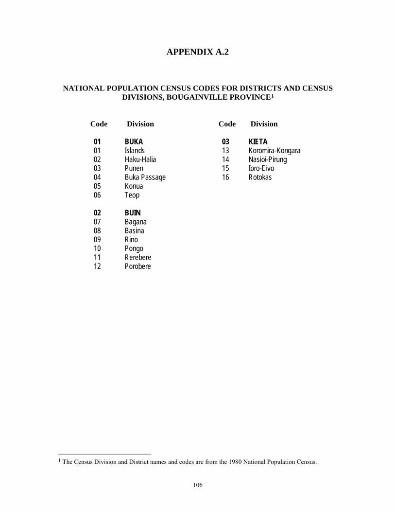