Agricultural Advisory Committee AGENDA
40
Agricultural Advisory Committee AGENDA Thursday, October 12, 2017 6:00 pm Council Chamber City Hall, 1435 Water Street Pages 1. Call to Order THE CHAIR WILL CALL THE MEETING TO ORDER: (a) The purpose of this Meeting is to consider certain Development Applications as noted on this meeting Agenda. (b) The Reports to Committee concerning the subject development applications are available on the City's website at www.kelowna.ca. (c) All representations to the Agricultural Advisory Committee form part of the public record. (d) As an Advisory Committee of Council, the Agricultural Advisory Comittee will make a recommendation of support or non-support for each application as part of the public process. City Council will consider the application at a future date and, depending on the nature of the file, will make a decision or a recommendation to the Agricultural Land Commission. 2. Applications for Consideration 2.1 1085 Lexington Drive, A17-0009 - Tom Stanbrook (Aspen Grove Golf Ltd.) 3 - 17 The applicant is requesting permission from the Agricultural Advisory Committee (AAC) to allow for Non-Farm Use on 1.4 ha (3.4 ac) area of a larger 21.46 ha (53.03 ac) parcel of land (Michaelbrook Ranch Golf Course). The land is within the Agricultural Land Reserve (ALR). The non-farm use is to allow a Recreational Vehicle (RV) Campsite on the property, proposed to contain 30-40 sites. The subject property is adjacent to Mission Recreation Park and Thomson Marsh Park. 2.2 841 Curtis Road, A17-0007 - Art & Linda Scheffler 18 - 31 The applicant is requesting permission from the Agricultural Advisory Committee (AAC) to allow for a Non-Farm Use to place up to 1372 cubic metres of fill to the property and reclaim to agriculture, under Section 20(3) of the Agricultural Land Commission Act.
Transcript of Agricultural Advisory Committee AGENDA
Agricultural Advisory Committee
AGENDA
Thursday, October 12, 2017
6:00 pm
Council Chamber
City Hall, 1435 Water StreetPages
1. Call to Order
THE CHAIR WILL CALL THE MEETING TO ORDER:
(a) The purpose of this Meeting is to consider certain Development Applications as noted onthis meeting Agenda.
(b) The Reports to Committee concerning the subject development applications areavailable on the City's website at www.kelowna.ca.
(c) All representations to the Agricultural Advisory Committee form part of the publicrecord.
(d) As an Advisory Committee of Council, the Agricultural Advisory Comittee will make arecommendation of support or non-support for each application as part of the public process. City Council will consider the application at a future date and, depending on the nature of thefile, will make a decision or a recommendation to the Agricultural Land Commission.
2. Applications for Consideration
2.1 1085 Lexington Drive, A17-0009 - Tom Stanbrook (Aspen Grove Golf Ltd.) 3 - 17
The applicant is requesting permission from the Agricultural Advisory Committee(AAC) to allow for Non-Farm Use on 1.4 ha (3.4 ac) area of a larger 21.46 ha (53.03 ac)parcel of land (Michaelbrook Ranch Golf Course). The land is within the AgriculturalLand Reserve (ALR). The non-farm use is to allow a Recreational Vehicle (RV)Campsite on the property, proposed to contain 30-40 sites. The subject property isadjacent to Mission Recreation Park and Thomson Marsh Park.
2.2 841 Curtis Road, A17-0007 - Art & Linda Scheffler 18 - 31
The applicant is requesting permission from the Agricultural Advisory Committee(AAC) to allow for a Non-Farm Use to place up to 1372 cubic metres of fill to theproperty and reclaim to agriculture, under Section 20(3) of the Agricultural LandCommission Act.

2.3 Community Engagement Process – Agricultural Water Rate Design 32 - 34
To inform the Committee of the engagement strategy to inform consideration of anew water rate design for agricultural water customers with which to update theWater Regulation Bylaw No. 10550.
3. ALC Decisions - Update
To provide the Committee with an update on Agricultural Land Commission decisions.
4. Minutes 35 - 40
Approve Minutes of the Meeting of August 10, 2017.
5. Old Business
5.1 Report to Council Discussion
To discuss the items the Committee would like to include in the Annual Report to CityCouncil.
6. Next Meeting
November 9, 2017
7. Termination of Meeting
2

COMMITTEE REPORT
Date: October 12, 2017
RIM No. 1210-21
To: Agricultural Advisory Committee (AAC)
From: Community Planning Department (KB)
Application: A17-0009 Owner: Tom Stanbrook (Aspen Grove Golf Ltd.)
Address: 1085 Lexington Drive Applicant: Dale Pilling (D.E. Pilling & Assoc.)
Subject: Application to the AAC for the Development of an Recreational Vehicle Campsite
Existing OCP Designation: REC – Private Recreation
Existing Zone: P3 – Parks and Open Space
1.0 Purpose
The applicant is requesting permission from the Agricultural Advisory Committee (AAC) to allow for Non-Farm Use on 1.4 ha (3.4 ac) area of a larger 21.46 ha (53.03 ac) parcel of land (Michaelbrook Ranch Golf Course). The land is within the Agricultural Land Reserve (ALR). The non-farm use is to allow a Recreational Vehicle (RV) Campsite on the property, proposed to contain 30-40 sites. The subject property is adjacent to Mission Recreation Park and Thomson Marsh Park.
2.0 Community Planning
The Offical Community Plan (OCP) recommends general non-support for non-farm uses in the ALR, unless there is a direct and significant benefit to agriculture. In addition, Council has taken the step of prohibiting the use of agri-tourist accommodation in the A1 – Agriculture 1 zone. The OCP states the objective to ‘Protect and enhance local agriculture’[1]. To this end, it lays out multiple policies, including Policy 5.33.6 regarding non-farm uses, whereby it states:
that there should be support of non-farm use applications on agricultural lands only where approved by the ALC and where the proposed uses:
are consistent with the Zoning Bylaw and OCP;
provide significant benefits to local agriculture;
can be accommodated using existing municipal infrastructure;
minimize impacts on productive agricultural lands;
will not preclude future use of the lands for agriculture; [1] City of Kelowna 2030 Official Community Plan: Agricultural Land Use Policies Chapter. P. 5.35.
3

A17-0009 – Page 2
will not harm adjacent farm operations.
Community Planning Staff are requesting for the AAC to provide a recommendation for Council (or either support or non-support) for the application for the development of a RV Campsite at Michaelbrook Ranch Golf Course.
3.0 Proposal
3.1 Background The Michaelbrook Ranch Golf Course is an 18 hole golf course which has been an allowable Non-Farm use since 1990. The 21.3 ha (52.73 ac) parcel incorporates a clubhouse/restaurant, operations building, owners residence, parking area and a former ‘pitch and putt’ area. The 1.4 ha (3.4 ac) former putting course is the proposed location of the RV Campsite. The site currently sits idle.
Michaelbrook Ranch Golf Course is accessed by Lexington Drive through the adjacent Mission Recreation Park. The Park is home to numerous facilities including community gardens, softball and soccer fields, a playground, dog park and trails. At the nearby H2O Adventure & Fitness Centre and Capital News Centre, the associated swimming pools, arenas and indoor and outdoor fields host numerous tournaments and camps for various sports including hockey, soccer, track, lacrosse, rugby, figure skating and speed skating. It is proposed that the RV campsites would offer an alternate accommodation choice that is not currently available within the immediate area. Under the ALC regulation, agri-tourist accommodation may be regulated or prohibited by local government bylaw. In 2010, the City of Kelowna adopted Bylaw 10269, regulated the siting and number of units permitted on a property based on size of property. In 2016, City Council approved Bylaw 11265, which prohibited any further agri-tourism accommodation operations in the City. If approved, the subject property would require either a text amendment, or a rezoning to a zone which allows for tourist campsites, in which a registered covenant restricting use on the property would be required. A brief history of agri-tourism accommodation in the ALR within the City follows in Table 1, below.
Table 1: History of Agri-tourism Accommodation in the ALR
Year Agency Action Result
2003 Province
of BC
Included agri-tourist accommodation as a permitted non-farm use in the ALC Regulation, one that can be regulated or prohibited by local government.
13 Agri-tourist Accommodation operations built through this regulation.
2010 City of
Kelowna
Approved the A1t – Agriculture 1 with Agri-tourist Accommodation zone, which outlined specific regulations for agri-tourist operations in the City .
2 properties received the A1t zone between 2010 and 2016.
2016 City of
Kelowna
Removed the A1-t – Agriculture 1 with Agri-tourist Accommodation zone as a permitted use in the A1 zone.
No additional agri-tourist operations since 2017.
4

A17-0009 – Page 3
3.2 Site Context
The location of the area to be redeveloped is the most westerly portion of the Michaelbrook Ranch Golf Course parcel and adjacent to both Mission Recreation Park and Thomson Marsh Park. The golf course was permitted as a Non-Farm Use in 1990. The subject area was developed as putting greens, which is no longer in use, and is separated from the 18 hole golf course by the clubhouse and parking lot.
Map 1 – Neighbourhood
Subject Property
Proposed RV
Campsite
5

A17-0009 – Page 4
Map 2 – Agricultural Land Reserve
Map 3 – Future Land Use
Subject Property
Proposed RV
Campsite
Resource
Protection Area
Park
Private
Recreation
Subject Property
6

A17-0009 – Page 5
3.3 Neighbourhood Context
The subject property lies within the Agricultural Land Reserve. It is zoned P3 – Parks and Open Space and the Future Land Use is Private Recreation. It is located outside of the Permanent Growth Boundary.
Zoning and land uses adjacent to the property are as follows:
Table 2: Zoning and Land Use of Adjacent Property
Direction Zoning ALR Land Use
North A1 – Agriculture 1 Yes Agriculture
South A1 – Agriculture 1 Yes Agriculture
East A1 – Agriculture 1 Yes Agriculture
West P5LP – Municipal District Park
(Liquor Primary) No Park / Natural Area / Recreation
3.4 Agricultural Land Capability
The Agricultural Land Capability of the subject property is is primarily Class 4 with some Class 5 occurring. It has a high organic content with limitations due to wetness (high water table). With improvements (e.g. drainage works such as ditching), the capability can be improved to Class 2 with some Class 3 occurring. Class 1 – 3 are considered to be the best land for most crops and are relatively rare in the Okanagan.
7

A17-0009 – Page 6
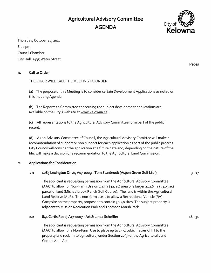
Map 4 – Land Capabilities Map
2.5 Soil Capability
The soils on the property are primarily (80%) Rumohr soils, which have 20 – 60 cm of decomposed organics overlaying up to 50 cm of marl. These typically have a high water table but, with drainage improvements, are typically used for vegetable or hay production.
A minor portion (20%) of the soils is Kendall soils. These soils are comprised with a well decomposed organic layer that is 40-160 cm thick, underlain by sand or loamy sand. These soils are usually cleared for hay production.
8
A17-0009 – Page 7
Map 5 – Soil Capabilities Map
Report prepared by: Kimberly Brunet, Planner Approved for Inclusion: Todd Cashin, Suburban and Rural Planning Manager
Attachments:
Schedule A – Policies Proposed Site Map
9

A17-0009 – Page 1
SCHEDULE A - Policies
Subject: 1085 Lexington Drive
Agriculture Plan (2017)
Appendix D Table 1 – Recommended Official Community Plan Updates[1]
Action 1.1c Restrict non-farm uses that do not directly benefit agriculture. Only support non-farm uses in farm areas that have a direct and ongoing benefit to agriculture or meet essential requirements of municipal government.
City of Kelowna Strategic Plan
Objective1: Sensitively integrate new development with heritage resources and existing urban, agricultural and rural areas. Action towards this objective2: Evaluate the effectiveness of City policies and bylaws in preserving agricultural lands.
Kelowna Official Community Plan (OCP)
Chapter 04 - Land Use Designation Definitions
Resource Protection Area (REP)3 Generally land areas within this designation (whether they are within the permanent growth boundary or not) will not be supported for exclusion from the ALR or for more intensive development than that allowed under current zoning regulations, except in specific circumstances where the City of Kelowna will allow exceptions to satisfy civic objectives for the provision of park/recreation uses. Major Park/Open Space (public) (PARK)4 City, District, Community, Neighbourhood and Linear parks. Not all parks required over the next 20 years are indicated on the map, as Neighbourhood parks will be provided at City standards as integral components of new and redevelopment initiatives. A major Recreation Park will be provided in the Glenmore Valley area. Open space indicated at the south end of Ellison Lake is intended as wildlife habitat preservation subject to approval of the appropriate provincial ministry or agency.
[1] City of Kelowna, 2017. Agriculture Plan - Appendix D Table 1 – Recommended Official Community Plan Updates p. 44 1 City of Kelowna Strategic Plan. 2004. P. 7. 2 City of Kelowna Strategic Plan. 2004. P. 29. 3 City of Kelowna 2030 Official Community Plan. Future Land Use Chapter. P. 4.2. 4 City of Kelowna 2030 Official Community Plan. Future Land Use Chapter. P. 4.6.
10

A17-0009 – Page 2
Private Recreation (REC)5 Large-scale recreation uses such as golf courses, driving ranges, and rifle ranges, operating as commercial ventures or clubs. Permanent Growth boundary6 Lands within the permanent growth boundary may be considered for urban uses within the 20 year planning horizon ending 2030. Lands outside the permanent growth boundary will not be supported for urban uses. Chapter 05 – Development Process
Objective 5.3 Focus development to designated growth areas.
Policy .1 Permanent Growth Boundary7. Establish a Permanent Growth Boundary as identified on Map 4.1 and Map 5.2. Support development of property outside the Permanent Growth Boundary for more intensive uses only to the extent permitted as per the OCP Future Land Use designations in place as of initial adoption of OCP Bylaw 10500, except as per Council’s specific amendment of this policy. Resource Protection Area designated properties not in the ALR and outside the Permanent Growth Boundary will not be supported for subdivision below parcel sizes of 4.0 ha (10 acres). The Permanent Growth Boundary may be reviewed as part of the next major OCP update. Agricultural Land Use Policies
Objective 5.33 Protect and enhance local agriculture8.
Policy .1 Protect Agricultural Land. Retain the agricultural land base by supporting the ALR and by protecting agricultural lands from development, except as otherwise noted in the City of Kelowna Agricultural Plan. Ensure that the primary use of agricultural land is agriculture, regardless of parcel size. Policy .2 ALR Exclusions. The City of Kelowna will not forward ALR exclusion applications to the ALC except in extraordinary circumstances where such exclusion is otherwise consistent with the goals, objectives and other policies of this OCP. Soil capability alone should not be used as justification for exclusion. Policy .3 Urban Uses. Direct urban uses to lands within the urban portion of the Permanent Growth Boundary, in the interest of reducing development and speculative pressure on agricultural lands.
Agricultural Land Commission Act (ALCA)
Purposes of the commission – Section 6 of the ALCA
The following are the purposes of the commission:
(a) to preserve agricultural land; 5 City of Kelowna 2030 Official Community Plan. Future Land Use Chapter. P. 4.6. 6 City of Kelowna 2030 Official Community Plan. Future Land Use Chapter. P. 4.6. 7 City of Kelowna 2030 Official Community Plan. Development Process Chapter. P. 5.2. 8 City of Kelowna 2030 Official Community Plan: Agricultural Land Use Policies Chapter. P. 5.35.
11

A17-0009 – Page 3
(b) to encourage farming on agricultural land in collaboration with other
communities of interest;
(c) to encourage local governments, first nations, the government and its
agents to enable and accommodate farm use of agricultural land and uses
compatible with agriculture in their plans, bylaws and policies.
12

13

14

15

16

17

COMMITTEE REPORT
Date: October 5, 2017
RIM No. 1210-21
To: Agricultural Advisory Committee (AAC)
From: Community Planning Department (SS)
Application: A17-0007 Owner: Art Scheffler Linda Scheffler
Address: 841 Curtis Road Applicant: Art Scheffler
Subject: Application to the ALC for Non-Farm Use in the ALR for the Placement of Fill
1.0 Purpose
The applicant is requesting permission from the Agricultural Advisory Committee (AAC) to allow for a Non-Farm Use to place up to 1372 cubic metres of fill to the property and reclaim to agriculture, under Section 20(3) of the Agricultural Land Commission Act.
2.0 Community Planning
Staff supports the application as proposed. The application proposes to place up to 1372 cubic metres of fill, with the intent of enhancing the existing pasture, to the property.The proposal is supported by a professional agrologist’s report, with a placement plan to improve the site for agriculture. The purpose of the placement of gravel fill is to facilitate “flushing” of salts from the soils in their pasture. The plan is to layer the gravel fill material above the existing low lying areas followed by layers of topsoil placed above the gravel fill to ensure a drained seed bed.
Community Planning Staff are requesting the AAC provide a recommendation for Council of support for the placement of fill. Should the ALC approve the Non-Farm Use, the applicant will be required to attain a Soil Permit from the City of Kelowna.
3.0 Proposal
3.1 Background
The subject property was purchased by the owners in 1984. It is currently largely pasture. A dwelling, shop and small accessory buildings are on the southeast corner of the site. The applicants have previously cultivated the pasture resulting in poor plant growth due to high levels of Potassium, Magnesium, Sodium and Sulfate. These areas will then be covered with fill and topsoil, disked and prepared for planting. They plan to restore a healthy pasture.
18

A17-0007
3.2 Project Description
The proposal is to place fill and topsoil over a 3-year period. The soil placement would be used to fill in low spots and be cultivated reseeded to enhance the present usage of the land. The goal is to regrade the property to a continuous gradual slope from the existing driveway to the north limit of the property. The agrologist’s report is attached.
3.3 Site Context
The subject property is located in the North Glenmore, Sector of the City and is within the Agricultural Land Reserve. The Future Land Use of the property is Resource Protection Area (REP). It is zoned A1 – Agriculture 1 (Maps 1 – 4, below) and is outside of the Permanent Growth Boundary. The property slopes from the south to the north, with a height of land at the south property line of 436.0 metres, sloping to the north property line at 435.0 metres, with a slope over the property which averages approximately 1%.
Parcel Summary – 841 Curtis Rd:
Parcel Size: 2.62 ha (6.47 acres) Elevation: 436.0 to 435.0 metres above sea level (masl) (approx.)
Zoning and land uses adjacent to the property are as follows:
Table 1: Zoning and Land Use of Adjacent Property
Direction Zoning ALR Land Use
North A1 – Agriculture 1 Yes Agriculture / Rural Residential
South A1 – Agriculture 1
Yes Agriculture / Rural Residential
East A1 – Agriculture 1
Yes Agriculture
West A1 – Agriculture 1
Yes Agriculture / Rural Residential
19

A17-0007
Map 1 - Neighbourhood
Map 2 – Agricultural Land Reserve
Curtis Road
Subject Property
Robert Lake
Subject Property
Curtis Road
20

A17-0007
Map 3 – Future Land Use
Map 4-Zoning
Subject Property
Resource Protection Area
Resource Protection Area
A1 – Agriculture 1
Subject Property
21

A17-0007
4.0 Current Development Policies
4.1 Kelowna Official Community Plan (OCP)
Protect and enhance local agriculture1.
Protect Agricultural Land. Retain the agricultural land base by supporting the ALR and by protecting agricultural lands from development, except as otherwise noted in the City of Kelowna Agricultural Plan. Ensure that the primary use of agricultural land is agriculture, regardless of parcel size.
Non-farm Uses. Support non-farm use applications on agricultural lands only where approved by the ALC and where the proposed uses:
are consistent with the Zoning Bylaw and OCP;
provide significant benefits to local agriculture;
can be accommodated using existing municipal infrastructure;
minimize impacts on productive agricultural lands;
will not preclude future use of the lands for agriculture; and
will not harm adjacent farm operations.
4.2 Natural Environment Development Permit Areas2
Unless exempted, a development permit addressing natural environment and water conservation guidelines must be approved before:
Subdivision of land;
Alternation of land, including but not limited to clearing, grading, blasting, preparation for or construction of services, and roads and trails;
Drilling a well for consumptive or geothermal purposes; and/or
Construction of, addition to, or alteration of a building or structure;
For those properties shown as Natural Environment Development Permit Areas.
4.3 City of Kelowna Agriculture Plan (1998)
ALR Application Criteria3 Exclusion, subdivision, or non-farm use of ALR lands will generally not be supported. General non-support for ALR applications is in the interest of protecting farmland through retention of larger parcels, protection of the land base from impacts of urban encroachment, reducing land speculation and the cost of entering the farm business, and encouraging increased farm capitalization.
4.4 Agricultural Land Commission Act (ALCA)
Section 6 Purposes of the Commission
The following are the purposes of the commission:
(a) to preserve agricultural land;
(b) to encourage farming on agricultural land in collaboration with other communities of interest;
1 City of Kelowna, 2012. 2030 Official Community Plan: Greening Our Future (2011), Development Process Chapter; p. 5.33. 2 City of Kelowna, 2012., 2030 Official Community Plan; Chapter 12 – Natural Environment DP 3 City of Kelowna Agriculture Plan. 1998. P. 130.
22
A17-0007
(c) to encourage local governments, first nations, the government and its agents to enable and accommodate farm use of agricultural land and uses compatible with agriculture in their plans, bylaws and policies.
Report prepared by: Sergio Sartori, Development Technician
Approved for Inclusion: Todd Cashin, Community Planning Department Manager
Attachments:
Photos Agrology Report
23

A17-0007
24

2533 Copper Ridge Drive, West Kelowna, BC, V4T 2X6,
Phone: 250-707-4664, Cell: 250-804-1798, email: [email protected]
R.G. (Bob) Holtby, MSc, PAg. Principal
August 29, 2017
To: Whom it may concern
RE: Gravel Placement
1.0 Introduction
Art and Linda Scheffler have asked me to provide a professional report in support of their
application to apply gravel fill on their property known as:
That Part of Lot 11, Shown on Plan B16248, Block 15, Sections 3 and 10,
Township 23, Osoyoos Division, Yale District, Plan 1068, PID 008-590-
834, at 841 Curtis Road, Kelowna, BC.
The location of the property is shown in Figure 1:
Figure 1: Location of the Scheffler Property
2.0 Qualifications
I am a licensed Agrologist and have been a full member of the B.C. Institute of
Agrologists since 1971 (except 2001-2002). I am a graduate from the University of
British Columbia with a Bachelor of Science degree in 1967, specializing in Agriculture
Economics, and a Master of Science degree in 1972, specializing in Farm Management.
My thesis for my Master’s degree was entitled Resource Allocation for the Median Peace
River Farm in British Columbia
Subject Parcel
25

An Opinion on an Application to Place Fill Page 2
Art and Linda Scheffler
During my years in both public and private practice, Courts and Review Boards have
accepted me as an expert regarding farming practices in British Columbia.
I am currently a member of the Environmental Appeal Board and the Forest Appeals
Commission. Following these appointments, I have received training in Administrative
Law and the Rules of Natural Justice.
The reader should note that I do not act as an agent in the normal use of the term. That is,
I have no fiduciary responsibility to the applicant.
Section 3 of the Code of Ethics of the BC Institute of Agrologists includes the paragraph:
• ensure that they provide an objective expert opinion and not an opinion that
advocates for their client or employer or a particular partisan position.
3.0 The Proposal
The purpose of the placement of gravel fill is to facilitate “flushing” of salts from the
soils in their pasture. Specifically, the low lying area to the North West of the parcel
have been identified as containing high levels of Potassium, Magnesium, Sodium and
Sulfate. In addition, the pH of the soils as a result of the salts is 8.3, clearly alkaline and
not conducive to good plant growth.
These levels were identified in a soils report from Griffin Laboratories Inc. in May, 2002.
I know of no remedial action having been taken in the intervening years and therefore
feel confident in assuming that these levels still exist.
Flushing the salts over time is the known remedy for this action. Normally, the farmer
uses tile drainage to remove the salts which are dissolved in the irrigation water. While
effective, tile drainage is also expensive. In addition, the Scheffler property contains
heavy clays (see Photograph 1) and the ability for water to drain through the clays is
suspect. The higher knolls on the property on the south along the driveway do not exhibit
the same effect of alkalinity or salt saturation. Water from these knolls will drain along
the surface to the lower part of the pasture which is the subject of this proposal.
Photograph 1: Soil Pit in Area to be Drained
26

An Opinion on an Application to Place Fill Page 3
Art and Linda Scheffler
Mr. Scheffler has provided a sketch map for his property that identifies the area to be
drained. These are identified as Fill A or Fill B. This map is shown in Figure 2:
Figure 2: Sketch Map for the Drainage Plan
In this case, there are two proposals which, depending on the nature of the gravel fill to
be imported, can be effectively and economically used, in my opinion.
If the gravels to be brought into the land contain a large amount of fine material, the best
approach in my opinion is to layer the material above the existing low lying area. Layers
of topsoil can then be placed above the gravels to ensure a drained seedbed.
This process will allow the flushed water to drain through the now higher ground and will
connect to the existing drainage ditch on the property boundary on the north side of the
property. This drained water will follow the normal course through the ditch to the lake.
27

An Opinion on an Application to Place Fill Page 4
Art and Linda Scheffler
If the gravel material is relatively clean, I would recommend trenching the land in a
herring bone pattern with a plow at about a one foot depth and filling the trench with the
clean material. This process would be much cheaper to perform since less material is
handled. The trenches are best described as “French drains” which are commonly used
for water management.
Again, the water will flow to the existing ditch (see Photograph 2) and follow the normal
path to the lake.
Photograph 2: Interception Ditch on North of Parcel
Improving drainage on a property is considered a “normal farm practice” according to the
Farm Industry Review Board.1
"normal farm practice" means a practice that is conducted by a farm
business in a manner consistent with
(a) proper and accepted customs and standards as established and followed
by similar farm businesses under similar circumstances, and
1 Section 1, Farm Practices Protection (Right to Farm) Act, RSBC 1996,
28

An Opinion on an Application to Place Fill Page 5
Art and Linda Scheffler
(b) any standards prescribed by the Lieutenant Governor in Council,
and includes a practice that makes use of innovative technology in a
manner consistent with proper advanced farm management practices and
with any standards prescribed under paragraph (b).
In the decision in Hall vs Rohrer, the Panel of FIRB declared that:2
We accept that a landowner has the right to improve drainage, subject to
any applicable land use regulation, to more effectively use his property
and maximize the profitability of his land.
This decision is contingent on no adverse effect of the drainage improvements on
neighbouring properties. Given the use of existing ditches, I know of no such adverse
effects on neighbouring properties.
The plan of Mr. and Mrs. Scheffler can in my opinion, meets the criteria of “normal farm
practice.”
I will be pleased to answer any questions that may have been raised by my opinion.
Respectfully submitted,
R.G. (Bob) Holtby, P.Ag.
2 Hall vs Rohrer, FIRB Decision, August 26, 2010
29
30

31

COMMITTEE REPORT
Date: October 12, 2017
RIM No. 1210-21
To: Agricultural Advisory Committee (AAC)
From: Kevin Van Vliet, Utility Services Manager
Subject: Community Engagement Process – Agricultural Water Rate Design
1.0 Purpose
To inform the Committee of the engagement strategy to inform consideration of a new water rate design for agricultural water customers with which to update the Water Regulation Bylaw No. 10550.
2.0 Background
With more than 12,000 hectares of the City’s land base zoned agriculture, agriculture is integral to the history and identity of Kelowna and is a key consideration in the City’s community planning, economic development and sustainability. During the engagement process for the recently endorsed Agriculture Plan, water was identified as a concern by growers and residents. To that end the Agriculture Plan identified two actions for ongoing and long-term implementation which the upcoming engagement is also consistent with, namely:
2a: Evaluate and monitor City of Kelowna water pricing with the goal of sustaining agriculture and; 2f: Continue to work towards ensuring sustainable, redundant and secure water for all agriculture.
The pending transition of Southeast Kelowna customers into the City system and the separation of the irrigation and domestic water supplies has resulted in the need for the City to review its agriculture rate and rate design to ensure that necessary Water Regulation Bylaw updates result in fair rates that encourage conservation and support farming operations. The City of Kelowna water utility currently has sixteen customers (as of January 2017) that are in the “Agricultural” customer class. City agricultural customers pay a fee of $0.114 per cubic metre for all water consumed on the property. There is no additional fee for a residence. In contrast, South East Kelowna Irrigation District (SEKID) currently charges a fixed fee per acre of land that has been allocated water. Residences pay a separate, additional water fee. This rate design provides more stability to the farmer in predicting costs but little incentive to use less than their given allocation. On a spectrum of charging for water, the City and SEKID rate models are at opposite ends. In the middle are many options that combine a fixed component with a variable component based on water use, such as the system used for City of Kelowna residential and commercial customer classes. Incorporation of SEKID’s and the South Okanagan Mission Irrigation Districts’s (SOMID) agricultural customers into the City of Kelowna water utility necessitates that the City’s current agricultural rate design
32

FILE NUMBER – Page
be changed. The City has committed to consulting with the agricultural community and reporting back to Council on what might be a more appropriate rate design. While SEKID will continue to set the irrigation rates for customers in 2018 and 2019, we hope to give customers assurance and advance notice of any changes to the rate design that may affect them and are therefore planning consultation to occur this fall and winter. Engagement Process: The communication and engagement process seeks to outline options for an agriculture rate design and provide Council with recommendations on a preferred option moving forward after 2019. In all forms of consultation, emphasis will be placed on considering both collective and individual needs, ensuring all voices are heard and analyzing the range of issues. Guided by an engagement plan reflecting the City’s Public Engagement Guiding Principles and Engagement Policy staff will facilitate meaningful dialogue amongst stakeholders across the community, not just SEKID customers, as any current or potential City agriculture customers will also be affected by any rate design adopted. Opportunities for a broader discussion by all members of the community will also be available. The goals of the engagement process include:
To inform customers and stakeholders with balanced and objective information To engage customers and stakeholders in the rate design process To create opportunities for customer and stakeholder input on rate design, billing cycle preferences
and agricultural customer classifications To create broader understanding of the value of the water utility and investment of customers in
water resource stewardship To create understanding of the value of water use efficiency and water conservation
A variety of direct in-person and online public consultation techniques will be used to reach a variety of stakeholders, identify issues and gather input for the plan. The engagement process will start in mid-September and will be conducted as below. The consultation will focus on engaging the directly impacted agricultural customers but will provide opportunities for broader community and stakeholder input. The following stakeholders have been identified as having either direct or indirect interest in the subject: Direct interest: SEKID Board of Trustees Agricultural Advisory Committee (AAC) SEKID Agricultural Customers Current City Agricultural Customers SOMID Agricultural Customers City Council Indirect interest: Industry Groups Other Water Improvement Districts/Communities Summerland Research and Development Centre Regional District of Central Okanagan First Nations
33
FILE NUMBER – Page
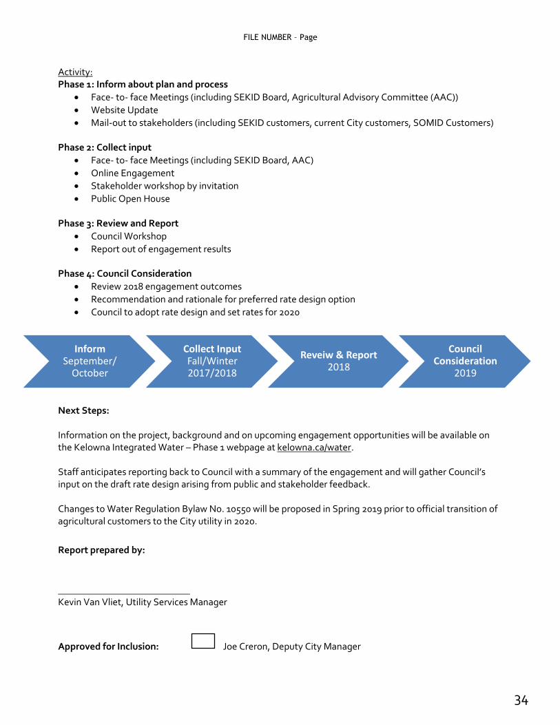
InformSeptember/
October
Collect InputFall/Winter 2017/2018
Reveiw & Report2018
Council Consideration
2019
Activity: Phase 1: Inform about plan and process
Face- to- face Meetings (including SEKID Board, Agricultural Advisory Committee (AAC))
Website Update
Mail-out to stakeholders (including SEKID customers, current City customers, SOMID Customers) Phase 2: Collect input
Face- to- face Meetings (including SEKID Board, AAC)
Online Engagement
Stakeholder workshop by invitation
Public Open House Phase 3: Review and Report
Council Workshop
Report out of engagement results Phase 4: Council Consideration
Review 2018 engagement outcomes
Recommendation and rationale for preferred rate design option
Council to adopt rate design and set rates for 2020 Next Steps: Information on the project, background and on upcoming engagement opportunities will be available on the Kelowna Integrated Water – Phase 1 webpage at kelowna.ca/water. Staff anticipates reporting back to Council with a summary of the engagement and will gather Council’s input on the draft rate design arising from public and stakeholder feedback. Changes to Water Regulation Bylaw No. 10550 will be proposed in Spring 2019 prior to official transition of agricultural customers to the City utility in 2020.
Report prepared by:
Kevin Van Vliet, Utility Services Manager
Approved for Inclusion: Joe Creron, Deputy City Manager
34

35
36

37

38
39

40