AGGREGATESPAVETHEWAYTOVICTORY: WORK … · WORK OF ROYAL ENGINEERS GEOLOGISTS AND QUARRYING...
17
AGGREGATES PAVE THE WAY TO VICTORY: WORK OF ROYAL ENGINEERS GEOLOGISTS AND QUARRYING COMPANIES DURING WORLD WAR II, ESPECIALLY FOR THE LIBERATION OF NORMANDY E.P.F. ROSE Honorary Research Fellow, Department of Earth Sciences, Royal Holloway, University of London, Egham, Surrey TW20 0EX, UK INTRODUCTION 6 June 1944, D-Day for Allied forces landing in Normandy, marked the greatest amphibious invasion in history. Nearly 7,000 ships and landing craft sailed from ports in southern England, assembled off the French coast (Figure 1), and then landed five divisions: the spearhead of the Allied Expeditionary Force. In total, over 75,000 British and Canadian and about 57,000 United States troops were landed by sea or air on that day, at a cost of about 4,300 Anglo-Canadian and 6,000 American casualties. By the end of June, the five divisions had been reinforced to form the British 2nd Army and the US 1st Army, together comprising 21st Army Group and in total over 850,000 troops. It is a story of heroism that has been told in many books and films, and is commemorated by extensive displays in an impressive D-Day Museum in Portsmouth, one of the major UK ports involved. But even the Museum makes no direct mention of how geologists and members of the UK extractive industry contributed to Allied victory in the ABSTRACT The Allied liberation of Normandy that began on D-Day, 6 June 1944, and the consequent North-West Europe Campaign that culminated in Victory in Europe on 8 May 1945, provide a classic case history of the military use of geologists and of quarrying for aggregates by British armed forces. Using geology, Major (later Lieutenant-Colonel) W.B.R. King helped guide the choice of Calvados rather than the Cherbourg Peninsula as an invasion area and Captain (later Major) F.W. Shotton helped plan the invasion routes across particular beach areas. Both compiled prospect maps to guide siting of numerous temporary airfields and boreholes to extract potable groundwater. Before and after the invasion, Shotton also intermittently advised Lieutenant-Colonel A.R.O. Williams: a former mining engineer with geological training who had served with distinction on Gibraltar, who was appointed in 1944 to found and command the Quarry Group Royal Engineers. The Group comprised five of the eight Royal Engineers Quarrying Companies formed during the war (numbers 125, 853, 855, 856, and 858), which had served variously in the UK, Faroe Islands, Gibraltar and Algeria/Tunisia before Normandy. (The other three of the eight, numbers 851, 854, and 857, after Scotland and North Africa, were serving at that time in the Mediterranean region, in the continuing Italian Campaign.) The Group began with a total key strength of about 900 all ranks, initially recruited mostly from the UK quarrying industry. It provided the aggregate required by 21st Army Group for road construction and repair, and hard standings for airfields and munitions/stores depots. As the Allies advanced, quarries worked by the Group in France were replaced by quarries in Belgium and finally Germany. In total, over 40 sites were operated during the 11-month campaign, to supply over 1.5 million tons of stone, rising to some 50 sites and 2 million tons by September 1945, when the Group was disbanded. Its achievements made a significant contribution to Allied victory, and influenced preparation of an authoritative Royal Engineers postwar textbook. Rose, E.P.F. 2012. Aggregates pave the way to victory: work of Royal Engineers geologists and Quarrying Companies during World War II, especially for the liberation of Normandy. Pp. 24-40 in Hunger, E. and Walton, G. (Eds.) Proceedings of the 16th Extractive Industry Geology Conference, EIG Conferences Ltd, 194pp. e-mail: [email protected] Battle of Normandy, and subsequent phases of the North- West Europe Campaign that culminated in Victory in Europe on 8 May 1945. That is the story told here, combining a summary of earlier publications to provide context with new data from unpublished records. It begins with an account of geological work and of foundation of the Quarry Group Royal Engineers (RE) in preparation for D-Day; tells then of the foundation of eight Quarrying Companies RE earlier in the war and the operational service that preceded five Companies being combined to form the Group; and concludes with an outline of the Group’s work successively in France, Belgium and Germany. For brevity in citation, except where otherwise indicated in the text, details of military history are derived from Dear & Foot (1995) and further references therein; of the Quarry Group RE from Williams (1950) and a more extensive unpublished history preserved at the National 24 Aggregates pave the way to victory
Transcript of AGGREGATESPAVETHEWAYTOVICTORY: WORK … · WORK OF ROYAL ENGINEERS GEOLOGISTS AND QUARRYING...

AGGREGATES PAVE THE WAY TO VICTORY:WORK OF ROYAL ENGINEERS GEOLOGISTS AND QUARRYING COMPANIES DURINGWORLD WAR II, ESPECIALLY FOR THE LIBERATION OF NORMANDY
E.P.F. ROSE
Honorary Research Fellow, Department of Earth Sciences, Royal Holloway, University of London,Egham, Surrey TW20 0EX, UK
INTRODUCTION
6 June 1944, D-Day for Allied forces landing inNormandy, marked the greatest amphibious invasion inhistory. Nearly 7,000 ships and landing craft sailed fromports in southern England, assembled off the Frenchcoast (Figure 1), and then landed five divisions: thespearhead of the Allied Expeditionary Force. In total,over 75,000 British and Canadian and about 57,000United States troops were landed by sea or air on thatday, at a cost of about 4,300 Anglo-Canadian and 6,000American casualties. By the end of June, the fivedivisions had been reinforced to form the British 2ndArmy and the US 1st Army, together comprising 21stArmy Group and in total over 850,000 troops. It is a storyof heroism that has been told in many books and films,and is commemorated by extensive displays in animpressive D-Day Museum in Portsmouth, one of themajor UK ports involved. But even the Museum makesno direct mention of how geologists and members of theUK extractive industry contributed to Allied victory in the
ABSTRACT
The Allied liberation of Normandy that began on D-Day, 6 June 1944, and the consequent North-West EuropeCampaign that culminated in Victory in Europe on 8 May 1945, provide a classic case history of the military use ofgeologists and of quarrying for aggregates by British armed forces. Using geology, Major (later Lieutenant-Colonel)W.B.R. King helped guide the choice of Calvados rather than the Cherbourg Peninsula as an invasion area and Captain(later Major) F.W. Shotton helped plan the invasion routes across particular beach areas. Both compiled prospectmaps to guide siting of numerous temporary airfields and boreholes to extract potable groundwater. Before and afterthe invasion, Shotton also intermittently advised Lieutenant-Colonel A.R.O. Williams: a former mining engineer withgeological training who had served with distinction on Gibraltar, who was appointed in 1944 to found and commandthe Quarry Group Royal Engineers. The Group comprised five of the eight Royal Engineers Quarrying Companiesformed during the war (numbers 125, 853, 855, 856, and 858), which had served variously in the UK, Faroe Islands,Gibraltar and Algeria/Tunisia before Normandy. (The other three of the eight, numbers 851, 854, and 857, afterScotland and North Africa, were serving at that time in the Mediterranean region, in the continuing Italian Campaign.)The Group began with a total key strength of about 900 all ranks, initially recruited mostly from the UK quarryingindustry. It provided the aggregate required by 21st Army Group for road construction and repair, and hard standingsfor airfields and munitions/stores depots. As the Allies advanced, quarries worked by the Group in France werereplaced by quarries in Belgium and finally Germany. In total, over 40 sites were operated during the 11-monthcampaign, to supply over 1.5 million tons of stone, rising to some 50 sites and 2 million tons by September 1945,when the Group was disbanded. Its achievements made a significant contribution to Allied victory, and influencedpreparation of an authoritative Royal Engineers postwar textbook.
Rose, E.P.F. 2012. Aggregates pave the way to victory: work of Royal Engineers geologists and Quarrying Companiesduring World War II, especially for the liberation of Normandy. Pp. 24-40 in Hunger, E. and Walton, G. (Eds.)
Proceedings of the 16th Extractive Industry Geology Conference, EIG Conferences Ltd, 194pp.
e-mail: [email protected]
Battle of Normandy, and subsequent phases of the North-West Europe Campaign that culminated in Victory inEurope on 8 May 1945.
That is the story told here, combining a summary ofearlier publications to provide context with new datafrom unpublished records. It begins with an account ofgeological work and of foundation of the Quarry GroupRoyal Engineers (RE) in preparation for D-Day; tells thenof the foundation of eight Quarrying Companies REearlier in the war and the operational service thatpreceded five Companies being combined to form theGroup; and concludes with an outline of the Group’swork successively in France, Belgium and Germany. Forbrevity in citation, except where otherwise indicated inthe text, details of military history are derived from Dear& Foot (1995) and further references therein; of theQuarry Group RE from Williams (1950) and a moreextensive unpublished history preserved at the National
24
Aggregates pave the way to victory

Figure 1. Map illustrating major Allied invasion routes fromEngland to Normandy, 6 June 1944: much simplified. From Roseet al. (2002), courtesy of Springer Verlag.
Archives, Kew (as file reference WO 205/1190); ofindividual Quarrying Companies RE from file MT 39/492at the National Archives, plus 40 other files (within WO166, 169, 170, 171, 175 and 176) each containing up to adozen monthly War Diaries for these units, preparedinitially as ‘secret’ documents but now declassified; andof the military promotion dates of particular officers fromcontemporary editions of the Army List, also accessed atthe National Archives. Imperial rather than SI units areused, for consistency with the historical sources.
GEOLOGISTS IN OPERATIONAL PLANNING AND
PREPARATION
It was a geologist, Major W.B.R. King of the RoyalEngineers, from 1931 until the outbreak of war inSeptember 1939 Professor of Geology at UniversityCollege in the University of London, who was influentialin routing the invasion not through the port of Cherbourgand the Cotentin Peninsula extending from it to the southbut across the beaches of Calvados to the east of thePeninsula (Figure 1).
‘Bill’ King (Figure 2) had served as the first of threegeologists appointed to the British Expeditionary Forceon the Western Front, in Belgium and northern France,during World War I (Rose & Rosenbaum, 1993a: Rose,2004, 2009). He served from June 1915 until the end ofthe war, effectively as a hydrogeologist to guide the workof Well Boring Sections of the Royal Engineers drillingwells for potable water, before returning briefly to anappointment with the Geological Survey of England andWales, and then teaching at the University of Cambridgeuntil his appointment as a professor in London in 1931.
He was called up from the Army Officers EmergencyReserve on 13 September 1939, ten days after the start ofWorld War II, and sent again to France with the newBritish Expeditionary Force: the same man, to essentiallythe same place, to do the same sort of job as in WorldWar I. But on 10 May 1940 the German Army attackedwestwards, the Force was defeated, and some threeweeks later largely evacuated from Dunkirk. Bill Kingtoo was evacuated, but not before he had earned aMilitary Cross for his courage in convoying ammunition:his geological expertise was redundant in retreat. Backin England, King was sent to Northern Command for ayear, but then appointed Staff Officer (SO) (Geology) atGeneral Headquarters Home Forces: the Forces whichwere to develop into 21st Army Group.
In 1943 the Allies began planning in earnest for areturn to France. Once Normandy rather than the Straitsof Dover had been selected as a potential invasion route,the Cotentin Peninsula was the area initially chosen.Capture of Cherbourg, it was argued, would provide asuitably major port through which men and suppliescould be routed once the beach-head was established.However, to establish that beach-head, air superiorityover the battlefield was essential. The distance from
Figure 2. Part of a photograph showing W.B.R. King (Professor ofGeology at University College London, visiting examiner), seatedfront right, and F.W. Shotton (Lecturer in Geology), standing rearleft, with members of the Lapworth Club at the University ofBirmingham, 1934. From Ludford (2009), courtesy of Dr. AlbertLudford and the Geological Society of London.
E.P.F. Rose
25

Aggregates pave the way to victory
26
England was such that aircraft based in England couldonly spend a short time in theatre before returning for re-fueling. As SO (Geology), Bill King was therefore taskedwith selecting sites for a dozen temporary airfields to berapidly constructed in the beach-head area. These wouldsustain the fighter cover necessary to protect Allied shipsand troops from Luftwaffe attack, and the rocket-firing‘Typhoons’ that would harry German tanks and vehicleswhen mounting the predictable counter-attack.
King realized that the bedrock of the CotentinPeninsula formed part of the Armorican Massif: a regionof strong crystalline basement, largely granites, schistsand highly indurated medium to coarse-grainedsandstones (‘quartzites’), of Precambrian to Palaeozoicage (Figure 3). In spite of its general flatness and lowaltitude (<100 m), the surface undulates as aconsequence of stream erosion (the main rivers in deepvalleys) and differential weathering (resistant strataforming distinct ridges), and supports a cover ofwoodland and ‘bocage’: small fields separated by hedgesand ditches. Terrain more suitable for the rapidconstruction of airfields lay to the east, in the Calvadosregion of Normandy. There Mesozoic rocks formingthe western margin of the Paris Basin dipped verygently eastwards. Near-horizontal Mid-Jurassiclimestones, broadly similar to parts of the Inferior andGreat Oolite successions long quarried in the CotswoldHills and Oxfordshire in England, formed a plateaubetween the towns of Bayeux and Caen. Capped with athin (<5 m, most commonly 2.5 m) cover of Quaternaryloess, this was a well-drained region, of large fields,generally well-suited to the rapid construction oftemporary airfields (Rose & Pareyn, 1995, 1998, 2003;Rose, 2008).
King combined geological and topographical data inmid-1943 to generate a map (Figures 4 and 5) of North-
Figure 3. Part (showing Normandy) of the NW sheet of the 1:1million geological map of France published by the War Office in1943 (as GSGS 4452: reprinted from the Carte géologique deFrance, 3rd edition, of 1933). Bedrock of the Cherbourg (Cotentin)Peninsula forms part of the Armorican Massif, whose componentsare predominantly very old (Precambrian in age: coloured pink; orearly Palaeozoic: dark olive green) and very strong (granites:coloured red), with a complex pattern of outcrop. In contrast,bedrock from the Calvados (Bayeux-Caen) region eastwards ismuch younger and weaker, largely Mid-Jurassic limestones (blue) toCretaceous chalks (green) which dip gently eastwards as part of thewestern margin of the Paris Basin. Only the thickest deposits ofmore recent (Quaternary) age can be shown on a map of this scale,notably those (coloured pale buff) flooring the major river valleys.
West Europe, including Normandy, which classifiedground according to its relative suitability for rapidairfield construction. It was this map supported by hisadvice that helped determine the choice of invasion area.
Figure 4. Part of a map of northern France prepared by W.B.R.King in mid 1943 showing ground classified according to itssuitability for the rapid construction of temporary airfields. For key,see Figure 5. From Rose et al. (2006), courtesy of the LapworthMuseum of Geology, University of Birmingham, and the BritishCartographic Society.
Figure 5. Key to map illustrated as Figure 4. From Rose et al.(2006), courtesy of the Lapworth Museum of Geology, University ofBirmingham, and the British Cartographic Society.
Once that choice had been made, King was involvedin the initial stages of a wide range of geotechnical tasksto help prepare for the invasion (Table 2 in Rose, 2008),notably generation in September 1943 of the first maps ina series of groundwater prospect maps at the scale of1:50,000 for much of the French coast betweenCherbourg east to Calais (Robins et al., 2007; Rose et al.,2010). However, in October 1943 he was promoted tothe rank of lieutenant-colonel but released from the army
to take up appointment as Woodwardian Professor ofGeology in the University of Cambridge. He wassucceeded as SO (Geology) at HQ 21st Army Group bya protégé, Captain F.W. Shotton, also then of the RoyalEngineers.
‘Fred’ Shotton (Figure 2) had been taught by Kingwhilst an undergraduate at Cambridge. After graduation,he had lectured on geology at the University ofBirmingham before appointment to the staff atCambridge, but volunteered for the Army OfficersEmergency Reserve on King’s recommendation as warloomed (Rose & Rosenbaum, 1993b; Rose & Clatworthy,2008). Called up eventually in 1940, he had served in theUK as King’s assistant before service from May 1941 asthe military geologist within General HeadquartersMiddle East Command, based in Egypt, at Cairo (Rose,2012). The Allies were victorious in North Africa in May1943; another geologist, Captain J.V. Stephens, was sentthere from the UK in June to participate in thesubsequent Sicilian and Italian Campaigns (Rose &Clatworthy, 2007); and the now veteran Shotton returnedto England in September.
It was Shotton who was to gain distinction byextending the series of groundwater prospect maps (atscales of both 1:50,000 and 1:250,000) initiated by hismentor Bill King (Robins et al., 2007; Rose et al., 2010);apply his geological expertise to a wide range of othertasks as planning for D-Day advanced (Rose et al., 2006;Rose & Clatworthy, 2008); and serve in the theatre of
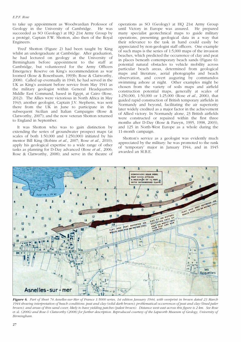
Figure 6. Part of Sheet 74 Asnelles-sur-Mer of France 1:5000 series, 1st edition January 1944, with overprint in brown dated 23 March1944 showing interpretation of beach conditions: peat and clay (solid dark brown); problematical occurrences of peat and clay (lined palerbrown); and areas of thin sand cover, likely to have yielding patches (palest brown). Distance west-east across this figure is 2 km. See Roseet al. (2006) and Rose & Clatworthy (2008) for further description. Reproduced courtesy of the Lapworth Museum of Geology, University ofBirmingham.
operations as SO (Geology) at HQ 21st Army Groupuntil Victory in Europe was assured. He preparedmany specialist geotechnical maps to guide militaryoperations, presenting geological data in a way thattheir relevance to the task in hand could easily beappreciated by non-geologist staff officers. One exampleof such maps is the series of 1:5,000 maps of the invasionbeaches, which predicted the occurrence of clay and peatin places beneath contemporary beach sands (Figure 6):potential natural obstacles to vehicle mobility acrossparticular beach areas, determined from geologicalmaps and literature, aerial photographs and beachobservation, and covert auguring by commandosswimming ashore at night. Other examples might bechosen from the variety of soils maps and airfieldconstruction potential maps, generally at scales of1:250,000, 1:50,000 or 1:25,000 (Rose et al., 2006), thatguided rapid construction of British temporary airfields inNormandy and beyond, facilitating the air superioritylater widely credited as a major factor in the achievementof Allied victory. In Normandy alone, 23 British airfieldswere constructed or repaired within the first threemonths after D-Day (Rose & Pareyn, 1995, 1998, 2003),and 125 in North-West Europe as a whole during the11-month campaign.
Shotton’s service as a geologist was evidently muchappreciated by the military: he was promoted to the rankof ‘temporary’ major in January 1944, and in 1945awarded an M.B.E.
E.P.F. Rose
27

Aggregates pave the way to victory
28
BILL WILLIAMS, COMMANDING OFFICER OF THE
QUARRY GROUP ROYAL ENGINEERS
Publications already cited provide detailed accounts ofwar work by Bill King and Fred Shotton, so this need notbe described further here. Rather, it is timely to drawattention to the wartime achievements of anotherdistinguished but lesser known military ‘geologist’: ArthurRobert Owen Williams (Figure 7).
Bill Williams was born about 1905, educated inEngland at Malvern, and from 1922 to 1926 studied at theRoyal School of Mines (RSM: now part of the ImperialCollege of Science, Technology and Medicine, London)(Anon., 1989). Subsequent issues of the Register of theAssociates and Old Students of the Royal School of Minesindicate that he graduated as an Associate (A.R.S.M.) inMetallurgy rather than Geology, but the Prospectus of theRoyal School of Mines published in the Imperial CollegeCalendar for the session 1922-23 shows that geology wasa component of the A.R.S.M. Metallurgy curriculum.Indeed, geology at this time included ‘crystallography,mineralogy, petrology, dynamical geology, tectonicgeology, stratigraphical geology, physiographic geology,palaeontological geology, and (optionally) determinativemineralogy’ and so was a significant feature of the course(C. Harpham, pers. comm. 2010).
Figure 7. A.R.O. Williams at Chatham in January 1940; part of agroup photograph of members of the newly-formed 170 TunnellingCompany Royal Engineers. From Wilson (1992), courtesy of theInstitute of Materials, Minerals and Mining, London.
According to the Register, on graduation Williamsmade his career in the metal mining industry. He wasemployed briefly in 1926 by Riley, Harbord & Law,before appointment as a ‘learner’ (and later promotion tochief sampler and shift boss) with Consolidated GoldFields at Robinson Deep in South Africa. From 1930 to1937 he worked sampling, surveying and mining at theKanshanshi Mine in what was then Northern Rhodesia(now Zambia), returning to England as Assistant to theChief Engineer at the London Office of ConsolidatedGold Fields. In 1938 he was seconded to Gold FieldsAmerican Development Company Limited, and took upresidence in Toronto. However, when war broke out inSeptember 1939, he returned as quickly as possible to theUK, to volunteer for active service.
Williams was speedily appointed to a Regular ArmyEmergency Commission, as a second lieutenant in theRoyal Engineers with effect from 14 November 1939. Hewas assigned to 170 Tunnelling Company RoyalEngineers (Wilson, 1992). This was the first of theTunnelling Companies RE formed during World War I butdisbanded at its end to be re-formed, at the School ofMilitary Engineering, Chatham, in late 1939. In early 1940Williams went with 170 (and 172 Tunnelling Companyraised soon afterwards) to excavate undergroundfacilities for the British Expeditionary Force in France, butwas soon ordered back to England to found andcommand 180 Tunnelling Company. He was thus in theUK and spared participation in the disastrous Battle ofFrance and retreat to Dunkirk in May/June 1940.Promoted to the rank of captain and then major in 1940,he led 180 Tunnelling Company to Gibraltar in October.There it participated in an extensive military tunnellingprogramme through the Jurassic limestone and dolomitebedrock (Wilson, 1945; Rosenbaum & Rose, 1991; Rose,2001). On 15 August 1942 Williams was promoted, to theranks of ‘substantive’ major and ‘temporary’ lieutenant-colonel, and given overall command of tunnellingoperations on Gibraltar, as Commanding Royal Engineer(C.R.E.) of 3rd Tunnelling Group. His earlier work onGibraltar had also been rewarded with an M.B.E. Heseemingly left Gibraltar in late 1943 or early 1944, for byMarch 1944 he was serving in the UK as C.R.E. of 9th Lineof Communications (L. of C.) Troops Engineers, based atDoncaster. On 15 March he attended a meeting at HQNorthern Command in York where he learnt that he wasto be assigned, with 9 L. of C. Troops Engineers, to theWorks Directorate of 21st Army Group, then preparingfor the Allied liberation of France. Five QuarryingCompanies Royal Engineers, the only such units to beassigned to 21st Army Group, were to be placed underhis command: numbers 125, 853, 855, 856, and 858.These would form the Quarry Group Royal Engineers,and as they did so, he would relinquish commandresponsibility for other RE units within 9 L. of C.
FOUNDATION OF QUARRYING COMPANIES ROYAL
ENGINEERS
Like Tunnelling Companies, Quarrying Companies hadfirst been formed within the Royal Engineers duringWorld War I, for service with the British ExpeditionaryForce on the Western Front, in Belgium and northernFrance. Like them, they were disbanded following theend of hostilities, but re-formed during World War II, to

serve again in France, with the new British ExpeditionaryForce (BEF).
Documents now preserved in the National Archives, atKew, in file MT 39/492, reveal that formation of aQuarrying Company RE was proposed in June 1939, aswar seemed likely. This was still in the planning stagefor men and equipment when the BEF asked in Octoberthat its formation be stopped. The French had refused toallocate the BEF a quarry on the grounds that theythemselves could meet all BEF requirements foraggregate.
However, as the BEF was reinforced to about 400,000men, and plans were formulated to enlarge it further, bya second army, the situation changed. On 16 March 1940the possibility of raising Quarrying Companies amongstother specialist Royal Engineers companies was raised.Plans then developed rapidly through April, and on 6May a meeting was convened in London by the WarOffice to consider formation of eleven QuarryingCompanies RE. Chaired by a Royal Engineers colonel,this was attended by representatives of the War Office,Ministry of Transport, Institute of Quarrying, BritishGranite and Whinstone Federation, British Slag MacadamFederation, and British Limestone (Roadstone)Federation.
Letters and messages sent after the conferencegenerated an instant and impressive response from theUK extractive industry. On 7 May came the news thatH.K. Symington had offered to recruit a QuarryingCompany at once in south-east Scotland. On 8 May, J.E.Weatherill, Manager of the Skipton Rock Co. Ltd., offered
Table 1. Foundation of Quarrying Companies Royal Engineers 1939-1945.
to raise a Company of 120 men under his managementfor service overseas. Indeed, by 8 May there were firmoffers to raise Companies not only in Airdrie, Scotland,and Skipton, in the West Riding of Yorkshire, England,but also in North Wales (Bangor) and Mid Wales(Festiniog). By 25 May it seemed probable that completeCompanies could be raised in seven, probably eight, UKdistricts. By 12 June five of these Companies were inprocess of formation, and efforts were in hand to recruitmen and potential officers.
But by then the BEF had been evacuated, and thesurrender of France to the Germans (on 22 June) wasimminent. Quarrying Companies were no longer neededfor service in France. On 20 June it was announced fromthe War Office that their formation would be curtailed,except for Companies that had progressed too far to bestopped without considerable disappointment andpossible hardship. Thus of the eleven Companiesenvisaged in May, only four were formed in 1940, in July(Table 1).
The Battle of France had been lost, and there was noimmediate military need for aggregate. But the aerialBattle of Britain that summer and then ‘the Blitz’ (theintensive bombing by the Luftwaffe of British cities fromAugust 1940 to mid-May 1941) brought an urgent large-scale need for new military capabilities: dealing withunexploded ordnance. Accordingly, after basic trainingin military and appropriate skills, the four QuarryingCompanies were employed from October in ‘bombdisposal’ roles. 125 was based at Chelmsford in Essex,851 at Blackheath and the south-east of London, 853 in
E.P.F. Rose
29

Aggregates pave the way to victory
30
served therefore at some time in Scotland, an indicationof the importance of this work to the war effort.
853 was also assigned to support construction of shorefacilities and airfields for the Battle of the Atlantic, but inNorthern Ireland, from January 1941 to May 1942.Londonderry became a major port for convoy protectionvessels. Royal Air Force Coastal Command squadrons onsimilar duties flew initially from four airfields and a flyingboat base, but 15 new airfields were soon constructed,and the province also later acted as a bridgehead forAmerican troops and aircraft being sent to Europe.Significant aggregate production began in April 1941 atBriar’s Quarry, Carrowdore, in County Down, andMorrow’s Quarry, White Mountain, in County Antrim. By20 May 1942 the Company was to produce over 136,239tons of stone, primarily from these two sources, before itsreturn to England.
In May 1942, 125 was at last sent overseas, togetherwith 856, which had been raised in 1941 (Table 1) andemployed quarrying in southern England (at Salisbury inCretaceous Chalk, Bournemouth in Cenozoic sandsand/or Quaternary gravels, and Woodstock, Oxfordshire,in Mid-Jurassic limestones). Both went not to a tropicalclimate but to the Faroe Islands, a constituent country ofthe Kingdom of Denmark half way between Scotland andIceland. The Islands were occupied by British troops on12 April 1940, following the invasion of Denmark byGerman forces, in order to strengthen British control inthe North Atlantic whilst the Battle of the Atlantic was inprogress. Between 1942 and 1943 Royal Engineers builtthe only airport on the islands, and the two QuarryingCompanies were deployed to aid this and associatedconstruction work. War Diaries show that from earlyJune, up to seven quarries in total were in operation,providing aggregate for a Flying Boat Base, sea wall,airfield runway, petrol dump, camp area, andconstruction works at the bay head, working parts of the3,000-m-thick sequence of Cenozoic lavas and pyroclasticrocks (Noe-Nygaard, 1962) which form the islands’bedrock. On 31 July 1943, as work came to an end, thefinal total output for the two companies over little morethan 14 months was recorded as 897,766 tons.
In July 1942, 855 also went overseas. After quarryingin Scotland, it had joined 125 quarrying at Skipton inYorkshire in January 1942, but in July it was shipped toGibraltar. This 6-km2 peninsula, jutting south from Spainat the western entrance to the Mediterranean Sea, isdominated by its famous ‘Rock’: a sharply-ridged crest ofsteeply-dipping Early Jurassic limestone and dolomitewith peaks over 400 m high (Rose, 2001). Ceded toBritain by the Treaty of Utrecht in 1713, Gibraltar hadbeen developed as a fortified naval base, one of the keyharbours from which the Royal Navy sought to dominatethe maritime world. Prior to the start of the war itsairfield, on the narrow isthmus to the north of the Rock,had been small and insignificant. However, Gibraltar wasimportant as a staging post between the UK, Malta, andEgypt, and later as a base first for the Allied (largelyAmerican) invasion of North-West Africa, and then ofsouthern France. This required that the airfield beextended to cope with more and larger aircraft. Forextension, land had to be reclaimed from the sea, bymeans of large quantities of ‘fill’. A start was made in1941, using spoil from tunnel excavation. In February
south-west England, and 854 in south London andSurrey. By January 1941, 853 had cleared some 500bombs within the counties of Devon, Cornwall,Somerset, Dorset, Wiltshire and Gloucestershire, butmostly in or near the port of Bristol; 854 had dealt with161 bombs of all sizes, including a landmine weighingtwo tons, plus innumerable anti-aircraft shells and flares;and 125 and 854 had been similarly busy. Quarrymen, itseems, coped well with handling explosives.
MILITARY QUARRYING IN THE EARLY YEARS OF
THE WAR
In January 1941, the four Companies were restructuredand re-roled. Each was now reduced in size to normallycomprise three officers and about 170 other ranks, andfrom August their commanding officers were all reducedfrom the rank of ‘acting’ major to that of ‘acting’ captain,appropriate to the smaller unit size. (Establishmentschanged during the war: a change notified about January1944 increased the number of officers to four, andrestored the senior officer’s rank to that of major.)Officers and men with particular bomb disposal expertiseformed the nucleus of other companies, and theQuarrying Companies were designated at last for moresuitable employment.
125 was sent north to Halifax in Yorkshire, for trainingand mobilization for imminent service overseas in atropical climate. But that assignment was successivelydelayed, and in October, finally cancelled. With trainingcomplete in May but no prospect of the expectedmovement orders, Major Weatherill (as he then was), itsOfficer Commanding, gained approval to base theCompany at Skipton, to work quarries at Skipton andSouthowram. Weekly output averaged about 1,200 tonsof aggregate (totaling over 55,000 tons by 31 December),bought by the War Office from Weatherill’s formeremployer, the Skipton Rock Co., for two shillings and sixpence per ton. The men were thus usefully employed,and having been recruited mostly from the Leeds,Bradford and Skipton district, content to be based in theirhome area whilst waiting expectantly for their promisedtropical posting.
The other three Companies were assigned roles in theUK, to support the enhancement of ports and airfieldscritical to British success in the maritime Battle of theAtlantic then in progress. 851 and 854 were sent toScotland, to quarry aggregate mostly used to build jettiesand roads for new ports, such as the military port atGarelochhead with access to the Clyde estuary. By 31July, 854 had delivered 41,000 tons, and was working adouble shift: from 06.15 to 14.15, and 14.15 to 22.15, perworking day. Output achieved 16,427 tons in September,but slowed to 4,475 in December as winter andconstruction projects diverted energies. Both 851 and854 were to continue this work in Scotland for a full twoyears, until January 1943. They were joined there fromMay to December 1941 by 855 Quarrying Company,deployed north soon after its formation (in April 1941) insouthern England. Their work was eventually taken overby 857 (also on formation) from October 1942 to July1943, succeeded in turn by 125 and 856 from autumn1943 until their deployment to Normandy in summer1944. Five of the eventual eight Companies to be raised

1942 an Excavator Company, a unique unit in the RoyalEngineers, was formed on Gibraltar, comprising aheadquarters, two motor transport sections and aquarrying section. Its main strength (five officers andover 200 other ranks) came from Royal Engineers,drivers, and pioneers shipped from the UK, butadditionally one officer and 25 other ranks from theRoyal Canadian Engineers provided a Diamond DrillSection to aid blasting. The Company worked an oldquarry on the north-east side of the Rock, and developeda new quarry in its North Face, adjacent to the airfield.Both were in massive slopes of weakly-cementedQuaternary scree breccia. 855 Quarrying Companyjoined this work in June, and from September alsoprovided working parties to assist 807 Road ConstructionCompany RE, newly-arrived to take part in airfieldconstruction. By July 1943 the full planned extensionwas complete, and 1.15 x 10⁶ m3 of fill had been placedin position: one of the great British military constructionachievements of the war. From August, Royal Engineersunits involved in airfield construction were thereforeprogressively dispersed to other duties.
MILITARY QUARRYING IN THE MEDITERRANEAN
REGION
855 moved from Gibraltar to quarry briefly in NorthAfrica, returning to the UK from the port of Algiers inJanuary 1944.
851 and 854 had arrived in Algeria much earlier,departing from Scotland in January 1943, to be followedby 857, also from Scotland, in July. Initially this was tosupport Allied forces engaged in the North AfricanCampaign, which had begun with largely Americanlandings in French Morocco and Algeria (soon reinforcedin the east near Algiers by the British 1st Army) inNovember 1942, and culminated in capitulation ofGerman-Italian forces in Tunisia in May 1943. Thereafterthe Companies assisted development of the infrastructurenecessary to support troops occupying and confiningprisoners of war in the eastern region, and those stagingto campaigns in Sicily (from July) and mainland Italy(from September). 851 was to work a series of quarriesin the northern part of Algeria, with seven in operationin the region of the port of Bone as its work drew to aclose in January 1944. 854 was similarly busy, in Algeriaand finally Tunisia, reporting in May 1943 that althoughall demands for stone were being met, the unit had notenough men to work all the quarries then in operation.Men of 857 arrived in Algiers on 28 July, but theirquarrying plant only on 18 August. The unit wasinvolved with quarrying and road construction near theport of Bizerte in Tunisia by October, moving back toAlgiers in December to take over two quarries from 855as this unit prepared to return to the UK. But primarily,or so it seems from its War Diaries, this unit was inwaiting for movement across the Mediterranean, to Italy.
Apart from 855, which moved back to the UK inJanuary 1944, all Quarrying Companies in North Africamoved to Italy: 854 via Taranto in December 1943 toAvelino for most of the year, and northwards to Perugiain November; 857 mostly via Naples in March 1944 tosupport the British 8th Army; and 851 also via Naples inMarch. These Companies changed HQ locations and the
quarries worked to keep pace with Allied troops as theyfought their way northwards, all being still in operationwhen the war in Europe ended on 8 May 1945.Thereafter, 854 remained in Italy until disbanded on 5December. 857 moved on into Austria in July, operatingthere until disbanded on 31 January 1946. 851 remainedin Italy, and was still in operation at the close of 1945,when its War Diaries come to an end. All three of theseCompanies therefore spent their entire time in militaryquarrying in only three areas: Scotland, North Africa, andItaly (briefly for 857 also adjacent Austria), and thusmostly overseas.
PREPARATION FOR ACTION IN NORMANDY
Early in 1944, two Quarrying Companies had longbeen working in England, 853 since return from NorthernIreland in May 1942, 858 since its formation, in March1943.
853 had been based at the Drill Hall, Woodstock,Oxfordshire, since June 1942, working Mid-Jurassiclimestone in the Gibraltar (Bletchingdon) and Kirtlingtonquarries nearby to provide crushed stone for the massiveCentral Ordnance Depot then under construction atBicester, a few miles to the east. Quarrying continueduntil August, when the Company moved to an RETraining Camp, for intensive training until earlySeptember. In early October it moved again, to a campat Otterburn, near Newcastle-on-Tyne, and there spent2.5 days per week on general military and engineeringtraining, the rest of working time quarrying stone,primarily for the construction of gun spurs andammunition dumps. Military training culminated in a 6-week period away in February/March, followed by morequarrying in late March through most of April. Thereafterthe Company was in transit camps at Selkirk, Scotland,and Tonbridge, Kent, before embarking for Normandy on17 June.
858 had begun forming on 23 March 1943 in Somerset,where it received basic military and engineering training,and technical training at Underwood Quarries, nearWells. On 30 July it moved to the Drill Hall, Woodstock,initially to take over from 853 whilst 853 went to itstraining camp but to share quarrying duties thereafter.Work began on Gibraltar Quarry the next day, tomaintain output of stone for the Central Ordnance Depot:9,447 cubic yards in August, 9,851 in September, 8,543 inOctober, 5,366 in November (a decrease caused bydiversion of energy to military training), and 6,737 inDecember. 858 continued quarrying at similar monthlyrates, punctuated with two weeks of military training inMarch/April, until handing over the Woodstockaccommodation and Gibraltar Quarry to 855 QuarryingCompany on 10 May, and moving first to RavenfieldCamp, near Rotherham, Yorkshire, before stagingsouthwards and finally embarking for Normandy on 24June.
856 had been based at Shandon, near Garelochhead,in Scotland, quarrying for two military ports, sincereturning to the UK from the Faroe Islands in September1943. By 16 May 1944 it too had completed a move toRavenfield Camp for military training, before stagingsouth in June, and finally embarking for Normandy on 10July.
E.P.F. Rose
31
Aggregates pave the way to victory
32
125 was also quarrying for military ports in Scotland,based at Garelochhead, until it too moved to RavenfieldCamp, arriving on 1 June. Despite a warning order on29 June to prepare to move at 48 hours notice, it did notmove south until mid July, and finally embarked forNormandy on 4 August.
855 had arrived back in England from Algeria on 4January 1944. Thereafter it was based in training campsuntil taking over the Gibraltar Quarry from 858 on 10May. However, barely a month later, on 15 June itmoved to Ravenfield Camp, beginning its subsequentmove south on 22 July, and embarking for Normandy on31 July.
All five of these Companies had thus by this timegained long experience in their specialist military role,
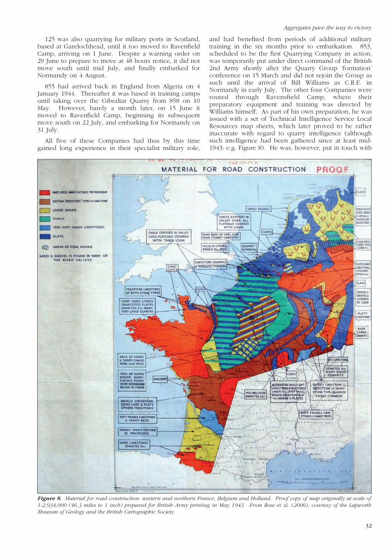
and had benefited from periods of additional militarytraining in the six months prior to embarkation. 853,scheduled to be the first Quarrying Company in action,was temporarily put under direct command of the British2nd Army shortly after the Quarry Group ‘formation’conference on 15 March and did not rejoin the Group assuch until the arrival of Bill Williams as C.R.E. inNormandy in early July. The other four Companies wererouted through Ravensfield Camp, where theirpreparatory equipment and training was directed byWilliams himself. As part of his own preparation, he wasissued with a set of Technical Intelligence Service LocalResources map sheets, which later proved to be ratherinaccurate with regard to quarry intelligence (althoughsuch intelligence had been gathered since at least mid-1943: e.g. Figure 8). He was, however, put in touch with
Figure 8. Material for road construction: western and northern France, Belgium and Holland. Proof copy of map originally at scale of1:2,934,000 (46.3 miles to 1 inch) prepared for British Army printing in May 1943. From Rose et al. (2006), courtesy of the LapworthMuseum of Geology and the British Cartographic Society.
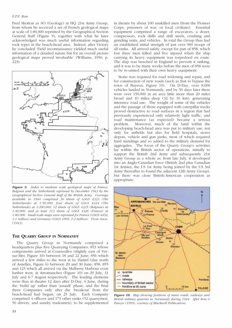
Fred Shotton as SO (Geology) at HQ 21st Army Group,from whom he received a set of French geological mapsat scale of 1:80,000 reprinted by the Geographical SectionGeneral Staff (Figure 9), together with what he lateracknowledged was much useful information regardingrock types in the beach-head area. Indeed, after Victoryhe concluded ‘Field reconnaissance yielded much usefulinformation of a detailed nature but for an overall picturegeological maps proved invaluable’ (Williams, 1950, p.223).
THE QUARRY GROUP IN NORMANDY
The Quarry Group in Normandy comprised aheadquarters plus five Quarrying Companies: 853 whosecomponents arrived at Courseulles (slightly east of Ver-sur-Mer, Figure 10) between 18 and 22 June; 856 whicharrived a few miles to the west at Le Hamel (due northof Asnelles, Figure 6) between 29 and 30 June; 858, 855and 125 which all arrived via the Mulberry Harbour evenfurther west, at Arromanches (Figure 10) on 29 July, 31July and 6-7 August respectively. The leading elementswere thus in theatre 12 days after D-Day, 6 June, duringthe ‘build up’ rather than ‘assault’ phase, and the finalthree Companies only after the ‘breakout’ from thebeach-head had begun, on 25 July. Each Companycomprised 4 officers and 173 other ranks (52 quarrymen,50 drivers, and sundry tradesmen), to be supplemented
Figure 9. Index to medium scale geological maps of France,Belgium and the Netherlands reprinted by December 1943 by theGeographical Section General Staff of the British Army. Coverageavailable in 1944 comprised 30 sheets of GSGS 4323 (TheNetherlands) at 1:50,000, four sheets of GSGS 4324 (TheNetherlands) at 1:200,000, 12 sheets of GSGS 4325 (Belgium) at1:40,000, and at least 113 sheets of GSGS 4326 (France) at1:80,000. Small-scale maps were reprinted for France (GSGS 4452,1:1 million) and Germany (GSGS 4505, 1:2 million). From Anon.(1943).
in theatre by about 100 unskilled men (from the PioneerCorps, prisoners of war, or local civilians). Essentialequipment comprised a range of excavators, a dozer,compressors, rock drills and drill steels, crushing andgrinding units, and vehicles. In total the Group thus hadan established initial strength of just over 900 troops ofall ranks. All arrived safely, except for part of 858, whichlost three men killed and five injured when the shipcarrying its heavy equipment was torpedoed en route.The ship was beached in England to prevent it sinking,and it was to be many weeks before the men of 858 wereto be re-united with their own heavy equipment.
Stone was required for road widening and repair, andfor construction of new roads (such as that to bypass thetown of Bayeux, Figure 10). On D-Day, over 8,000vehicles landed in Normandy, and by 50 days later therewere over 150,000 in an area little more than 20 milesbroad and 10 miles deep (32 by 16 km), generatingintensive road use. The weight of some of the vehiclesand the passage of those equipped with caterpillar tracksproved destructive to road surfaces in a region that hadpreviously experienced only relatively light traffic, androad maintenance (as expected) became a seriousproblem. Moreover, much of the land within thedeveloping beach-head area was put to military use, notonly for airfields but also for field hospitals, storesdepots, vehicle and gun parks, most of which requiredhard standings and so added to the military demand foraggregates. The focus of the Quarry Group’s activitieslay within the British sector of operations, initially tosupport the British 2nd Army and subsequently 21stArmy Group as a whole as, from late July, it developedinto an Anglo-Canadian force (British 2nd plus Canadian1st Armies, the US 1st Army being joined by the US 3rdArmy thereafter to found the adjacent 12th Army Group),but there was close British/American cooperation asappropriate.
Figure 10. Map showing positions of main roads, railways andBritish military quarries in Normandy during 1944. After Rose &Pareyn (1995), courtesy of Blackwell Publications.
E.P.F. Rose
33

Aggregates pave the way to victory
34
Initially, production was started in existing (but partlydisused) quarries at Creully, Esquay, Douvres, Reviers,Carpiquet, Blay, and Tilly-sur-Seulles (Figure 10 andTable 2). Later, a new quarry was opened at Ver-sur-Mer.Apart from two quarries near Esquay, in Quaternarysands or gravels, all these quarries were within Jurassiclimestones. They produced a rock that was weak andgenerally unsuitable for road repair, but within therestrictions imposed by the frontline andBritish/American sector boundary, there were noalternatives. At Creully (Figure 11) and comparable sites(Figure 12) the rock quarried was a Mid-Jurassic shallow-
water limestone with well-developed cross bedding,worked previously for building or rough walling stoneand somewhat similar to the Mid-Jurassic limestonesworked in England at the Gibraltar and Kirtingtonquarries. These strata dipped gently to the north-east,exposing Early Jurassic strata further inland, toward thesouth-west margin of the Jurassic outcrop. Quarries inthese Liassic limestones were developed at Blay, LesOrmes, and Tilly-sur-Seulles, working well-cementedlimestone beds 0.10-0.35 m thick alternating with thinnermarls, the limestones having previously been worked toburn for lime production.
Table 2. Stone delivered by Quarrying Companies RE in France 1944.

Figure 11. Creully, the most prolific of the ‘soft rock’ quarries operated by the Quarry Group RE in Normandy: photographed in 2001,showing face some 4 m high cut through Mid-Jurassic cross-bedded bioclastic limestones. From Rose & Pareyn (2003), courtesy of theGeologists’ Association.
Figure 12. Royal Engineers at work in a limestone quarry in Normandy during 1944. Photo courtesy of the Royal Engineers Museum andLibrary, Chatham.
E.P.F. Rose
35

Aggregates pave the way to victory
36
Good roadstone became available only with thecapture of Mouen (Figure 13), SW of Caen, toward theend of July. This provided access to strong, steeply-dipping Cambrian quartzites flanking a NW-SEprolongation of the Precambrian Armorican basement.
Bill Williams was diligent in visiting sites duringoperation, and in reconnaissance for new sites,sometimes accompanied by Fred Shotton to providegeological guidance. Weak rock quarries were setaside as those yielding stronger rocks became accessiblewith the progress of battle. Creully, Douvres, Reviers,Ver-sur-Mer, Blay, and Tilly, were successivelyabandoned, and the quartzite or well-cementedPalaeozoic sandstone quarries at Perrières, Etavaux,Maltot and St. Martin-des-Besaces brought to production.Choice of these particular quarries from the many thatbecame potentially available with the expansion of thebeach-head was dictated primarily by considerations ofproximity to areas most needing stone and the rapiditywith which production could be started. The Perrièresquarry was deemed the best, with good road and railaccess. Production began at the end of August andcontinued until the end of the war in May 1945,supplying British and American forces with over 70,000tons of stone, nearly all crushed, from this one source.However, as the Allied armies advanced, so Frenchquarries were replaced as sources of aggregate byquarries in Belgium and finally Germany. East of Caen,bedrock in France is principally of Cretaceous sediments(Figure 3), mostly chalks, capped in places with a
significant thickness of clay-with-flints and with somethick deposits of Quaternary gravel in the major (Seineand Eure) river valleys but otherwise with no potentialsources of good aggregate other than the urban areasreduced to rubble by aerial or artillery bombardment.The Marquise group of eleven quarries near Boulogneworked an inlier of older, stronger rocks, but althoughthese were important to British troops in World War I,they were quickly bypassed in World War II.
THE QUARRY GROUP IN BELGIUM AND GERMANY
The Normandy phase of quarrying came to an end on15 September. Allied troops had broken out of theextended beach-head area and advanced some 400 mileseastwards between 25 July and 7 September, acrossnorthern France to liberate Belgium. They consolidatedtheir position in the Low Countries during the wintermonths, and between 16 September and 30 Novemberthe Quarry Group extended its activities to Belgium, atthe same time maintaining some production in the Caen-Bayeux-Falaise region (Figure 10) to meet demands foraggregate in the Rear Maintenance Area of 21st ArmyGroup. By early November, 125 was quarrying atEtavaux; 853 at Mouen; 855 at Blay, St. Martin and LaFrance; 856 at Perrières, Carpiquet and Maltot; and 858(east of Figure 10) at Fontaine, Cocherel and Rouen (inurban rubble). In mid November, part of 855 was sent toOstend in Belgium, to crush Carboniferous limestone(found in a large dump near the docks) for tarmac
Figure 13. Mouen, the most prolific of the ‘hard rock’ quarries operated by the Quarry Group RE in Normandy: photographed in 2001,showing steeply-dipping Palaeozoic quartzites; excavator indicates scale. From Rose & Pareyn (2003), courtesy of the Geologists’Association.

manufacture, and elements of the Quarry Groupprogressively took over responsibility for organizing thesupply of all stone and tarmac from Belgian sources. Thehuge stocks of crushed rock found in Belgium, as well asthe need to form other Royal Engineer units within themanpower ceiling imposed on 21st Army Group, led tothe disbandment of 858 in December 1944. The lastQuarrying Company RE to be formed, it was deemedappropriate that it be the first to be disbanded – despiteprotests from the Quarry Group against any diminutionof its overall manpower.
From 1 December 1944 to 16 April 1945, the QuarryGroup concentrated activities in Belgium, where itcontrolled the supply of stone to two armies (1stCanadian and 2nd British) and their Line ofCommunications. Most came from quarries in porphyry(Table 3) near Brussels, principally at Lessines north-westof the city (the quarries at Unies, Nouvelles, Cosyns,Vandevelde, Mouplon, Sarts, Notte, and Cardoncontrolled by a selling organization in Brussels, plusWillocq, Denure and Le Porphyre), at Bierghes, and at
Quenast (the Quenast and Brabant quarries) to the southof the city, quarries mostly of impressive size (Figure 14).Quarries at Dongelberg to the east, and Opprebais, wereoperated from February onwards, to meet local demandsand relieve the rail lift position at Lessines, which wasalways difficult, but their output was small incomparison. Initially stone was distributed from stock,but demand required that quarrying be implemented,and civilian labour involved. By 1 April 1945, 125 wascontrolling stone production and/or issues at Lessines,Bierghes, Quenast, Soignies and Antwerp; 853 quarryingat Cosyns; 855 (from its headquarters in Valkenswaard)controlling activities such as stone crushing or tarmacproduction at Nijmegen, Weerpelt, Schaft, Hamont,Weert, Waterscheide and Ben-Ahin; and 856 quarrying atDongelberg and Opprebais (whilst still with one platoonoperating at Perrières). Moreover, 4854 Flight Royal AirForce was also brought under command by this time,quarrying at Dongelberg and crushing dumped materialat Le But.
Table 3. Stone delivered by Quarrying Companies RE in Belgium 1944/1945.
E.P.F. Rose
37

Aggregates pave the way to victory
38
From 17 April the Quarry Group began to moveforward into Germany. Its HQ had prepared for themove prior to Allied crossing of the River Rhine inmid/late March by making a study of all availableinformation regarding stone resources in northernGermany, by means of geological maps and publicationsand the help of the geologists then at HQ 21st ArmyGroup (Majors F.W. Shotton and D.R.A. Ponsford: cf.Rose & Clatworthy, 2008). Its task on arrival was theorganization of stone supplies from local sources, initiallyfor the British 2nd Army and later for the whole of Britishforces east of the Rhine. By the time Victory in Europewas achieved, on 8 May, only three quarries were inoperation (Table 4), in a line to the north of Osnabruck,but almost all of the Quarry Group had moved fromBelgium to Germany before the end of May. It was tocontinue operations until the end of August, at times at afurther 11 sites: quarries at Bentheim to the north-westand Bissendorf to the south of Osnabruck, and two atSteinbergen to the south-east towards Hanover, five in
basalt in the Hartz Mountains near Göttingen to the southof Hanover (Bramburg, Barterode, Guntersen, Dransfeldand Meensen), a ‘diabase’ quarry near Langelsheimnorth-east of this group, and a gravel washing plant atRinteln near Steinbergen.
By then, three of the Quarrying Companies had beenwithdrawn to England with a view to service with South-East Asia Command (and so in Burma, Malaya orSumatra). 856 embarked for the UK on 20 May, 125entrained in Germany on 21 July, 855 on 25 July(although Victory over Japan on 15 August speedilyremoved the need for their further operationaldeployment). The Quarry Group briefly comprised aheadquarters plus 853 Quarrying Company thereafter.Bill Williams was released from the Army on 23 Augustand succeeded as C.R.E. by Joseph Setchell, pre-warGeneral Manager of the Old Delabole Slate Company,who had founded 853 and later taken command of 858The Group ceased to be responsible for any stone
Table 4. Stone delivered by Quarrying Companies RE in Germany to 8 May 1945.
Figure 14. Quenast Quarry, Belgium (cf. Table 3), viewed to the south-east; photographed in March 2012 but showing infrastructure fromold workings near the crest. © Emily Hunger.
production outside Germany on 31 August, and wasfinally disbanded as such on 30 September. 853remained in Germany to support the British Army ofOccupation of the Rhine until adequate civilian supportwas in place. Then it too was disbanded, on 8 March1946.
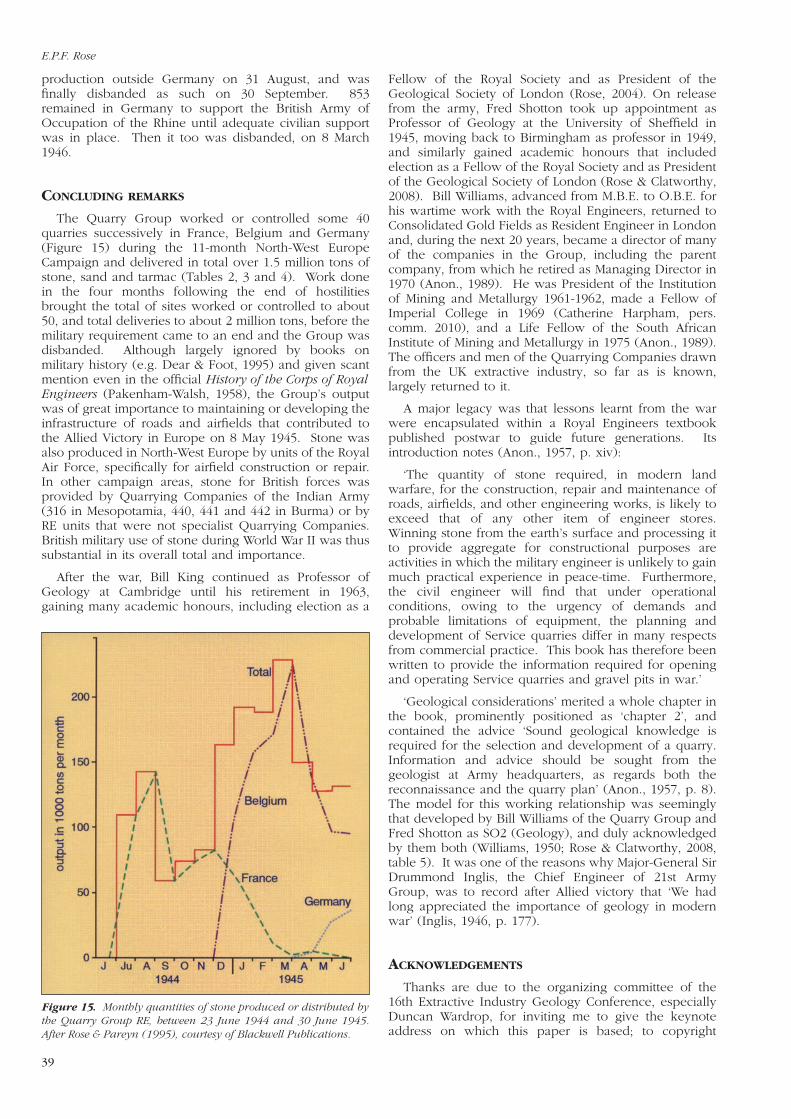
CONCLUDING REMARKS
The Quarry Group worked or controlled some 40quarries successively in France, Belgium and Germany(Figure 15) during the 11-month North-West EuropeCampaign and delivered in total over 1.5 million tons ofstone, sand and tarmac (Tables 2, 3 and 4). Work donein the four months following the end of hostilitiesbrought the total of sites worked or controlled to about50, and total deliveries to about 2 million tons, before themilitary requirement came to an end and the Group wasdisbanded. Although largely ignored by books onmilitary history (e.g. Dear & Foot, 1995) and given scantmention even in the official History of the Corps of RoyalEngineers (Pakenham-Walsh, 1958), the Group’s outputwas of great importance to maintaining or developing theinfrastructure of roads and airfields that contributed tothe Allied Victory in Europe on 8 May 1945. Stone wasalso produced in North-West Europe by units of the RoyalAir Force, specifically for airfield construction or repair.In other campaign areas, stone for British forces wasprovided by Quarrying Companies of the Indian Army(316 in Mesopotamia, 440, 441 and 442 in Burma) or byRE units that were not specialist Quarrying Companies.British military use of stone during World War II was thussubstantial in its overall total and importance.
After the war, Bill King continued as Professor ofGeology at Cambridge until his retirement in 1963,gaining many academic honours, including election as a
Fellow of the Royal Society and as President of theGeological Society of London (Rose, 2004). On releasefrom the army, Fred Shotton took up appointment asProfessor of Geology at the University of Sheffield in1945, moving back to Birmingham as professor in 1949,and similarly gained academic honours that includedelection as a Fellow of the Royal Society and as Presidentof the Geological Society of London (Rose & Clatworthy,2008). Bill Williams, advanced from M.B.E. to O.B.E. forhis wartime work with the Royal Engineers, returned toConsolidated Gold Fields as Resident Engineer in Londonand, during the next 20 years, became a director of manyof the companies in the Group, including the parentcompany, from which he retired as Managing Director in1970 (Anon., 1989). He was President of the Institutionof Mining and Metallurgy 1961-1962, made a Fellow ofImperial College in 1969 (Catherine Harpham, pers.comm. 2010), and a Life Fellow of the South AfricanInstitute of Mining and Metallurgy in 1975 (Anon., 1989).The officers and men of the Quarrying Companies drawnfrom the UK extractive industry, so far as is known,largely returned to it.
A major legacy was that lessons learnt from the warwere encapsulated within a Royal Engineers textbookpublished postwar to guide future generations. Itsintroduction notes (Anon., 1957, p. xiv):
‘The quantity of stone required, in modern landwarfare, for the construction, repair and maintenance ofroads, airfields, and other engineering works, is likely toexceed that of any other item of engineer stores.Winning stone from the earth’s surface and processing itto provide aggregate for constructional purposes areactivities in which the military engineer is unlikely to gainmuch practical experience in peace-time. Furthermore,the civil engineer will find that under operationalconditions, owing to the urgency of demands andprobable limitations of equipment, the planning anddevelopment of Service quarries differ in many respectsfrom commercial practice. This book has therefore beenwritten to provide the information required for openingand operating Service quarries and gravel pits in war.’
‘Geological considerations’ merited a whole chapter inthe book, prominently positioned as ‘chapter 2’, andcontained the advice ‘Sound geological knowledge isrequired for the selection and development of a quarry.Information and advice should be sought from thegeologist at Army headquarters, as regards both thereconnaissance and the quarry plan’ (Anon., 1957, p. 8).The model for this working relationship was seeminglythat developed by Bill Williams of the Quarry Group andFred Shotton as SO2 (Geology), and duly acknowledgedby them both (Williams, 1950; Rose & Clatworthy, 2008,table 5). It was one of the reasons why Major-General SirDrummond Inglis, the Chief Engineer of 21st ArmyGroup, was to record after Allied victory that ‘We hadlong appreciated the importance of geology in modernwar’ (Inglis, 1946, p. 177).
ACKNOWLEDGEMENTS
Thanks are due to the organizing committee of the16th Extractive Industry Geology Conference, especiallyDuncan Wardrop, for inviting me to give the keynoteaddress on which this paper is based; to copyright
Figure 15. Monthly quantities of stone produced or distributed bythe Quarry Group RE, between 23 June 1944 and 30 June 1945.After Rose & Pareyn (1995), courtesy of Blackwell Publications.
E.P.F. Rose
39

Aggregates pave the way to victory
40
owners as acknowledged in figure captions forpermission to re-use those illustrations publishedpreviously; to Wendy Cawthorne (Geological Society ofLondon), Dr Peter Sabine (British Geological Survey,retired), Catharine Harpham (Imperial College of Science,Technology and Medicine, London), and Frances Perry(Institute of Materials, Minerals and Mining) for efforts tolocate biographical data for Bill Williams; and staff at theNational Archives, Kew, for access to the War Diaries andother documents from which primary data used in thisarticle have been derived.
REFERENCES
Anon. 1943. Notes on G.S.G.S. maps of France, Belgium and Holland.Directorate of Military Survey, London.
Anon. 1957. Military engineering. Volume V. Part III. Quarries andgravel pits. WO Code no. 9422. War Office, London.
Anon. 1989. Obituary: A.R.O. Williams, O.B.E. Journal of the SouthAfrican Institute of Mining and Metallurgy, 89, 300.
Dear, I.C.B. & Foot, M.R.D. 1995. The Oxford Companion to theSecond World War. Oxford University Press, Oxford.
Inglis, J.D. 1946. The work of the Royal Engineers in North-WestEurope, 1944-45. Journal of the Royal United Service Institution, 91,176-195.
Ludford, A. 2009. Discussion of ‘Terrain evaluation for Allied militaryoperations in Europe and the Far East during World War II: “secret”British reports and specialist maps generated by the GeologicalSection, Inter-Service Topographical Department’, by E.P.F. Rose &J.C. Clatworthy, Quarterly Journal of Engineering Geology andHydrogeology, 41, 237-256. Quarterly Journal of EngineeringGeology and Hydrogeology, 42, 133-134.
Noe-Nygaard, A. 1962. The geology of the Faroes. Quarterly Journalof the Geological Society, London, 118, 375-383.
Pakenham-Walsh, R.P. 1958. History of the Corps of Royal Engineers.Vol. IX. 1938-1948. Campaigns in Sicily and Italy; the war againstJapan; North-West Europe, 1944-45; minor and non-operationalareas; post-war, 1945-48. Institution of Royal Engineers, Chatham.
Robins, N.S., Rose, E.P.F. & Clatworthy, J.C. 2007. Water supply mapsfor northern France created by British military geologists duringWorld War II: precursors of modern groundwater developmentpotential maps. Quarterly Journal of Engineering Geology andHydrogeology, 40, 47-65.
Rose, E.P.F. 2001. Military engineering on the Rock of Gibraltar and itsgeoenvironmental legacy. In: Ehlen, J. & Harmon, R.S. (eds) Theenvironmental legacy of military operations. Reviews inEngineering Geology 14. Geological Society of America, Boulder,Colorado, 95-121.
Rose, E.P.F. 2004. King, William Bernard Robinson (1889-1963). In:Matthew, H.G.C. & Harrison, B. (eds) Oxford Dictionary ofNational Biography. Vol. 31. Kebell-Knowlys. Oxford UniversityPress, Oxford, 691-692.
Rose, E.P.F. 2008. British military geological terrain evaluation forOperation Overlord: the Allied invasion of Normandy in June 1944.In: Nathanail, C.P., Abrahart, R.J. & Bradshaw, R.P. (eds) Militarygeography and geology: history and technology. Land Quality Press,Nottingham, 215-233.
Rose, E.P.F. 2009. Water supply maps for the Western Front (Belgiumand Northern France) developed by British, German and Americanmilitary geologists during World War I: pioneering studies inhydrogeology from trench warfare. The Cartographic Journal, 46,76-103.
Rose, E.P.F. 2012. Groundwater as a military resource: development ofRoyal Engineers Boring Sections and British military hydrogeologyin World War II. In: Rose, E.P.F. & Mather, J.D. (eds) Military
aspects of hydrogeology. Geological Society, London, SpecialPublications, 362, 105-138.
Rose, E.P.F. & Clatworthy, J.C. 2007. The Sicilian and Italian campaignsof World War II: roles of British military geologists in Allied engineer“Intelligence” and “Works”. Royal Engineers Journal, 121, 94-103.
Rose, E.P.F. & Clatworthy, J.C. 2008. Fred Shotton: a ‘hero’ of militaryapplications of geology during World War II. Quarterly Journal ofEngineering Geology and Hydrogeology, 41, 171-188.
Rose, E.P.F. & Pareyn, C. 1995. Geology and the liberation ofNormandy, France 1944. Geology Today, 11, 58-63.
Rose, E.P.F. & Pareyn, C. 1998. British applications of military geologyfor ‘Operation Overlord’ and the battle in Normandy, France, 1944.In: Underwood, J.R., Jr. & Guth, P.L. (eds) Military geology in warand peace. Reviews in Engineering Geology 13. Geological Societyof America, Boulder, Colorado, 55-66.
Rose, E.P.F. & Pareyn, C. 2003. Geology of the D-Day landings inNormandy, 1944. Geologists’ Association Guide No. 64. Geologists’Association, London.
Rose, E.P.F. & Rosenbaum, M.S. 1993a. British military geologists: theformative years to the end of the First World War. Proceedings ofthe Geologists’ Association, 104, 41-49.
Rose, E.P.F. & Rosenbaum, M.S. 1993b. British military geologists:through the Second World War to the end of the Cold War.Proceedings of the Geologists’ Association, 104, 95-108.
Rose, E.P.F., Ginns, W.M. & Renouf, J.T. 2002. Fortification of islandterrain: Second World War German military engineering on theChannel island of Jersey, a classic area of British geology. In:Doyle, P. & Bennett, M.R. (eds) Fields of battle: terrain in militaryhistory. Kluwer Academic Publishers, Dordrecht, 265-309.
Rose, E.P.F., Clatworthy, J.C. & Nathanail, C.P. 2006. Specialist mapsprepared by British military geologists for the D-Day landings andoperations in Normandy, 1944. The Cartographic Journal, 43, 117-143.
Rose, E.P.F., Clatworthy, J.C. & Robins, N.S. 2010. Water supply mapsfor North-west Europe developed by British military geologistsduring World War II: innovative mapping for mobile warfare. TheCartographic Journal, 47, 55-91.
Rosenbaum, M.S. & Rose, E.P.F. 1991. The tunnels of Gibraltar. TheGibraltar Museum, Gibraltar.
Williams, A.R.O. 1950. The Royal Engineer quarrying companies in theNorth-west European Campaign. Quarry Managers Journal, 34,214-225.
Wilson, A.J. 1992. The professionals: the Institution of Mining andMetallurgy 1892-1992. Institution of Mining and Metallurgy,London.
Wilson, W.H. 1945. Tunnelling in Gibraltar during the 1939-1945 war.Transactions of the Institution of Mining and Metallurgy, 55, 193-269.