AGENDA - City of Fremantle Agenda 2... · Elevation); SK14 (Section AA); SK15 (Section BB); ......
90
AGENDA Planning Committee Wednesday, 2 November 2016, 6.00pm
Transcript of AGENDA - City of Fremantle Agenda 2... · Elevation); SK14 (Section AA); SK15 (Section BB); ......

AGENDA
Planning Committee
Wednesday, 2 November 2016, 6.00pm


PLANNING COMMITTEE
AGENDA
DECLARATION OF OPENING / ANNOUNCEMENT OF VISITORS NYOONGAR ACKNOWLEDGEMENT STATEMENT "We acknowledge this land that we meet on today is part of the traditional lands of the Nyoongar people and that we respect their spiritual relationship with their country. We also acknowledge the Nyoongar people as the custodians of the greater Fremantle/Walyalup area and that their cultural and heritage beliefs are still important to the living Nyoongar people today." ATTENDANCE / APOLOGIES / LEAVE OF ABSENCE RESPONSE TO PREVIOUS PUBLIC QUESTIONS TAKEN ON NOTICE PUBLIC QUESTION TIME DEPUTATIONS / PRESENTATIONS DISCLOSURES OF INTEREST BY MEMBERS LATE ITEMS NOTED CONFIRMATION OF MINUTES That the minutes of the Planning Committee dated 5 October 2016 be confirmed as a true and accurate record. TABLED DOCUMENTS

TABLE OF CONTENTS
ITEM NO SUBJECT PAGE
DEFERRED ITEMS (COMMITTEE DELEGATION) 1
PC1611-1 ADELAIDE STREET NO. 52 (LOT 2) , FREMANTLE -DEMOLITION OF EXISTING BUILDING AND CONSTRUCTION OF AN EIGHT (8) STOREY (PLUS BASEMENT) MIXED USE DEVELOPMENT (71 X MULTIPLE DWELLINGS, 7 X COMMERCIAL TENANCIES) (AD DAP004/16) 1
REPORTS BY OFFICERS (COMMITTEE DELEGATION) 14
PC1611-2 NORFOLK STREET, NO.24 (LOTS 2 & 66), FREMANTLE - DEMOLITION OF EXISTING BUILDING AND CONSTRUCTION OF A FOUR (4) STOREY MIXED USE DEVELOPMENT (8 MULTIPLE DWELLINGS & 1 OFFICE) - (BP DA0350/16) 14
PC1611-3 MARINE TERRACE, NO. 88 (LOT 3), FREMANTLE - ADDITION OF EXTERNAL STAIRCASE TO EXISTING BUILDING - (CJ DA0401/16) 34
PC1611-4 COLLEGE CORNER, NO.25 (LOT 108), O'CONNOR - CHANGE OF USE TO HOME BUSINESS (WAREHOUSE) - (NB DA0471/16) 40
PC1611-5 THOMAS STREET, NO. 22 (LOT 141), SOUTH FREMANTLE - ADDITIONS AND ALTERATIONS TO EXISTING SINGLE STOREY SINGLE HOUSE (AD DA0386/16) 46
PC1611-6 DOURO ROAD, NO.4/19 (LOT 4), SOUTH FREMANTLE - VARIATION TO PREVIOUS PLANNING APPROVAL DA0256/16 (CHANGE OF USE FROM OFFICE TO CONSULTING ROOMS) - (BP VA0022/16) 53
PC1611-7 DOURO ROAD, NO.3/19 (LOT 3), SOUTH FREMANTLE - CHANGE OF USE FROM OFFICE TO SHOP IN AN EXISTING MIXED USE DEVELOPMENT (NB DA0453/16) 58
PC1611-8 HARBOUR ROAD, NO. 11 (LOT 56), SOUTH FREMANTLE - TWO STOREY ANCILLARY DWELLING ADDITION TO EXISTING SINGLE HOUSE- (CJ DA0400/16) 64
PC1611-9 SCHEDULE OF APPLICATIONS DETERMINED UNDER DELEGATED AUTHORITY 71
REPORTS BY OFFICERS (COUNCIL DECISION) 72
PC1611-10 PROPOSED AMENDMENT NO. 72 TO LOCAL PLANNING SCHEME 4 REZONING OF LAND BOUNDED BY SOUTH

STREET, FIFTH AVENUE, LEFROY ROAD AND CAESAR STREET, BEACONSFIELD TO DEVELOPMENT ZONE 72
CONFIDENTIAL MATTERS 80
AGENDA ATTACHMENTS 1
PC1611-1 ADELAIDE STREET NO. 52 (LOT 2) , FREMANTLE -DEMOLITION OF EXISTING BUILDING AND CONSTRUCTION OF AN EIGHT (8) STOREY (PLUS BASEMENT) MIXED USE DEVELOPMENT (71 X MULTIPLE DWELLINGS, 7 X COMMERCIAL TENANCIES) (AD DAP004/16) 3
PC1611-2 NORFOLK STREET, NO.24 (LOTS 2 & 66), FREMANTLE - DEMOLITION OF EXISTING BUILDING AND CONSTRUCTION OF A FOUR (4) STOREY MIXED USE DEVELOPMENT (8 MULTIPLE DWELLINGS & 1 OFFICE) - (BP DA0350/16) 103
PC1611-3 MARINE TERRACE, NO. 88 (LOT 3), FREMANTLE - ADDITION OF EXTERNAL STAIRCASE TO EXISTING BUILDING - (CJ DA0401/16) 166
PC1611-4 COLLEGE CORNER, NO.25 (LOT 108), O'CONNOR - CHANGE OF USE TO HOME BUSINESS (WAREHOUSE) - (NB DA0471/16) 167
PC1611-5 THOMAS STREET, NO. 22 (LOT 141), SOUTH FREMANTLE - ADDITIONS AND ALTERATIONS TO EXISTING SINGLE STOREY SINGLE HOUSE (AD DA0386/16) 184
PC1611-6 DOURO ROAD, NO.4/19 (LOT 4), SOUTH FREMANTLE - VARIATION TO PREVIOUS PLANNING APPROVAL DA0256/16 (CHANGE OF USE FROM OFFICE TO CONSULTING ROOMS) - (BP VA0022/16) 198
PC1611-7 DOURO ROAD, NO.3/19 (LOT 3), SOUTH FREMANTLE - CHANGE OF USE FROM OFFICE TO SHOP IN AN EXISTING MIXED USE DEVELOPMENT (NB DA0453/16) 208
PC1611-8 HARBOUR ROAD, NO. 11 (LOT 56), SOUTH FREMANTLE - TWO STOREY ANCILLARY DWELLING ADDITION TO EXISTING SINGLE HOUSE- (CJ DA0400/16) 214
PC1611-9 SCHEDULE OF APPLICATIONS DETERMINED UNDER DELEGATED AUTHORITY 219
PC1611-10 PROPOSED AMENDMENT NO. 72 TO LOCAL PLANNING SCHEME 4 REZONING OF LAND BOUNDED BY SOUTH STREET, FIFTH AVENUE, LEFROY ROAD AND CAESAR STREET, BEACONSFIELD TO DEVELOPMENT ZONE 222

Agenda - Planning Committee 2 November 2016
Page 1
DEFERRED ITEMS (COMMITTEE DELEGATION)
The following items are subject to clause 1.1 and 2.1 of the City of Fremantle Delegated Authority Register
PC1611-1 ADELAIDE STREET NO. 52 (LOT 2) , FREMANTLE -DEMOLITION OF EXISTING BUILDING AND CONSTRUCTION OF AN EIGHT (8) STOREY (PLUS BASEMENT) MIXED USE DEVELOPMENT (71 X MULTIPLE DWELLINGS, 7 X COMMERCIAL TENANCIES) (AD DAP004/16)
Form 1 -
Property Location: No. 52 (Lot 2) Adelaide Street, Fremantle
Application Details: Demolition of existing building and construction of an eight (8) storey (plus basement) Mixed use development (71 x Multiple Dwellings, 7 x Commercial tenancies)
DAP Name: Metro South-West Joint Development Assessment Panel
Applicant: Taylor Burrell Barnett
Owner: Glenwaye Pty Ltd
LG Reference: DAP004/16
Responsible Authority: City of Fremantle
Authorising Officer: A/Manager Development Approvals
Department of Planning File No: DAP/16/01060
Report Date: 31 October 2016
Application Receipt Date: 10 June 2016 14 October 2016 (amended plans)
Application Process Days: +90 days (deferral by JDAP)
Attachment(s): 1: Development Plans (as amended) 2: Original RAR
OFFICER RECOMMENDATION: That the Metropolitan South-West Joint Development Assessment Panel resolves to: REFUSE DAP Application reference DAP/16/01060 and accompanying plans dated 14 October 2016 (Plan reference: SK00; SK01; SK02 (site plan/site section CC); SK03 (Basement Floor Plan); SK04 (Ground Floor Plan); SK05 (First Floor Plan); SK06 (Second, Fourth, Sixth Floor Plan); SK07 (Third and Fifth Floor Plan); SK08 (Seventh Floor Plan); SK09 (Roof Plan); SK10 (East Elevation); SK11 (South Elevation – Westgate Mall); SK12 (West Elevation – Westgate Mall); SK13 (North Elevation); SK14 (Section AA); SK15 (Section BB); SK16 (Westgate Mall Conceptual Plan) in accordance with Clause 10.3.1(b) of the City of Local Planning Scheme No. 4, for the following reasons:

Agenda - Planning Committee 2 November 2016
Page 2
1. The proposal is inappropriate having regard Clause 1.3.2(e) of Schedule 12 of the City of Fremantle Local Planning Scheme 4 which relates to building height.
2. The proposal would be detrimental to the amenity of the area under clause 67(a), (b), (m), (n), (x) and (y) of the Planning and Development (Local Planning Schemes) Regulations 2015.
Background:
Insert Property Address: No. 52 (Lot 2) Adelaide Street, Fremantle
Insert Zoning MRS: Central City
TPS: City Centre
Insert Use Class: Residential: Multiple Dwelling ‘D’ Commercial: Office ‘P’; Shop ‘P’
Insert Strategy Policy: N/A
Insert Development Scheme: City of Fremantle Local Planning Scheme No. 4
Insert Lot Size: 1,492m2
Insert Existing Land Use: Shop (currently vacant)
Value of Development: $15,840,000
At its meeting of 19 September 2016 (meeting no. 112), the Metro South-West JDAP considered an application for the demolition of an existing building and construction of an eight (8) storey (plus basement) Mixed use development (72 x Multiple Dwellings, 7 x commercial tenancies) at No. 52 (Lot 2) Adelaide Street, Fremantle (DAP/16/01060), whereby it was resolved as follows:
“That the Metro South-West JDAP resolves to defer DAP Application reference DAP/16/01060 for a period of 6 weeks to allow the applicant to address the following:
1. The first floor level fronting Adelaide Street to be set closer to 4.5 metres above the level of the footpath adjacent to the site in general accordance with clause 1.3.2 (g) of schedule 12 of the City of Fremantle Local Planning Scheme No.4, whilst ensuring that the overall building height does not exceed 26.60m (AHD 30.7m), and
2. The maximum façade height facing Adelaide Street to be no higher than 21.0m (AHD 25.20M) and any portion of building exceeding this maximum façade height facing Adelaide Street to be set back sufficiently from the street façade so as to not be visible from Adelaide Street in general accordance with clause 1.3.2 (e)(i) of schedule 12 of Fremantle Local Planning Scheme No.4
REASON: The amendments sought to the plans were considered to be too significant a change to the proposal and would not satisfy the Newbury ‘but for test’ as a valid condition.”
Subsequent to the above JDAP deferral, on 14 October 2016, the City received amended plans from the applicant, which are contained as Attachment 1 of this report. As part of the applicant’s amended proposal, they have provided the following written response detailing the design changes:
Agenda - Planning Committee 2 November 2016
Page 3
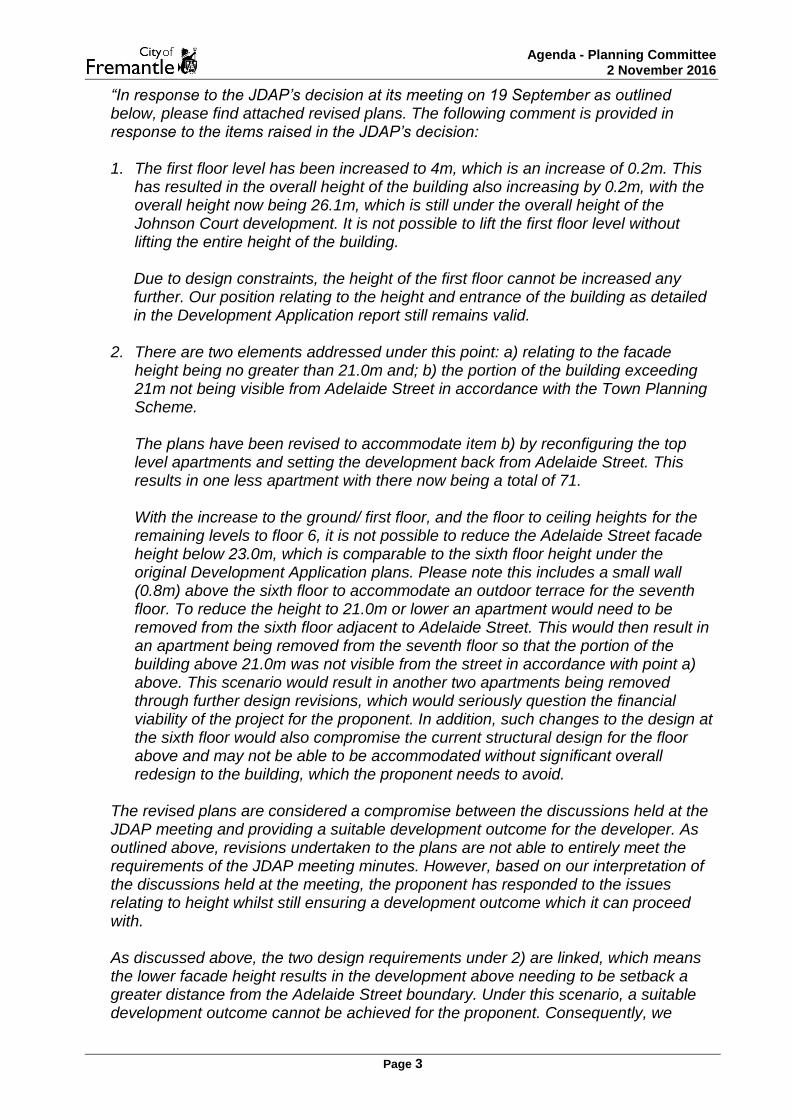
“In response to the JDAP’s decision at its meeting on 19 September as outlined below, please find attached revised plans. The following comment is provided in response to the items raised in the JDAP’s decision:
1. The first floor level has been increased to 4m, which is an increase of 0.2m. This
has resulted in the overall height of the building also increasing by 0.2m, with the overall height now being 26.1m, which is still under the overall height of the Johnson Court development. It is not possible to lift the first floor level without lifting the entire height of the building.
Due to design constraints, the height of the first floor cannot be increased any further. Our position relating to the height and entrance of the building as detailed in the Development Application report still remains valid.
2. There are two elements addressed under this point: a) relating to the facade
height being no greater than 21.0m and; b) the portion of the building exceeding 21m not being visible from Adelaide Street in accordance with the Town Planning Scheme. The plans have been revised to accommodate item b) by reconfiguring the top level apartments and setting the development back from Adelaide Street. This results in one less apartment with there now being a total of 71. With the increase to the ground/ first floor, and the floor to ceiling heights for the remaining levels to floor 6, it is not possible to reduce the Adelaide Street facade height below 23.0m, which is comparable to the sixth floor height under the original Development Application plans. Please note this includes a small wall (0.8m) above the sixth floor to accommodate an outdoor terrace for the seventh floor. To reduce the height to 21.0m or lower an apartment would need to be removed from the sixth floor adjacent to Adelaide Street. This would then result in an apartment being removed from the seventh floor so that the portion of the building above 21.0m was not visible from the street in accordance with point a) above. This scenario would result in another two apartments being removed through further design revisions, which would seriously question the financial viability of the project for the proponent. In addition, such changes to the design at the sixth floor would also compromise the current structural design for the floor above and may not be able to be accommodated without significant overall redesign to the building, which the proponent needs to avoid.
The revised plans are considered a compromise between the discussions held at the JDAP meeting and providing a suitable development outcome for the developer. As outlined above, revisions undertaken to the plans are not able to entirely meet the requirements of the JDAP meeting minutes. However, based on our interpretation of the discussions held at the meeting, the proponent has responded to the issues relating to height whilst still ensuring a development outcome which it can proceed with. As discussed above, the two design requirements under 2) are linked, which means the lower facade height results in the development above needing to be setback a greater distance from the Adelaide Street boundary. Under this scenario, a suitable development outcome cannot be achieved for the proponent. Consequently, we

Agenda - Planning Committee 2 November 2016
Page 4
question the intent of these provisions as a collective, as we believe for all intents and purposes the revised plans will still accommodate an appropriate height and suitable facade consistent with the overall objectives of the Town Planning Scheme relating to this locality. We trust the revised plans will meet with Council’s and the JDAP’s support. Should any further information or clarification be required regarding the above or the attached, please do not hesitate to contact the undersigned.”
Broadly speaking, the following table outlines the key differences (and similarities) between the original and amended proposals:
Design aspect Original Amended Difference
Overall height 25.9m 26.1m +0.2m
Façade height (fronting Adelaide St) 25.9m 23.0m -2.9m
7th level visible from the street? Yes No -
Ground floor height 3.8m 4.0m +0.2m
Floor to floor heights (above first floor) 3.0m 3.0m Nil
Number of dwellings 72 71 -1
Car parking bays 98 98 Nil
It is the intention of this RAR to discuss only the changes associated with the amended plans. The core planning issues discussed in the original RAR are considered pertinent to, and applicable to JDAP considering these amended plans – particularly in relation to height. In this regard, JDAP should read this RAR in conjunction with the original one, which is contained as Attachment 2 of this report. Please refer to the previous RAR report for further detail and discussion, which is contained as Attachment 2 of this report. Details: outline of development application Aside from the changes detailed in the table above, the development remains in substance the same as the original proposal. Refer to the original RAR for a full description of the proposal of which is contained as Attachment 2. Legislation & policy: Please refer to the previous RAR report for further detail and discussion, which is contained as Attachment 2 of this report. Consultation Public Consultation The amended plans were not required to be readvertised in accordance with Clause 9.4 of the LPS4, nor clause 6 of Council’s LPP1.3 as no new discretion to what was already being considered is being sought. Please refer to the previous RAR report for further detail and discussion, which is contained as Attachment 2 of this report.

Agenda - Planning Committee 2 November 2016
Page 5
Consultation with State Heritage Office (SHO) The City referred the amended plans to the SHO for consideration and comment. The SHO provided the following comments in relation to the amended proposal on 21 October 2016 (underlined for change):
“Findings
The development is in the block bound by Point, Adelaide, Queen and Cantonment Streets, and there are no registered places in the immediate vicinity.
Princess May Reserve is significant for its role in the development of education, and has high aesthetic value in relation to the design and use of construction materials, and is a landmark of significant value to the community.
St John’s Anglican Church has been an important place of worship from 1843, and its elegant proportions contribute to its aesthetic characteristics and landmark value within the Fremantle civic precinct.
St Patrick’s Basilica and Presbytery has a close association with the Oblate order, and is a landmark in the northern approach to the City as well as contributing to the streetscape qualities of Adelaide Street.
The Fremantle Town Hall is a fine example of Victorian Free Classical civic architecture, and being strategically located at the intersection of William and High Streets it makes a major contribution to the streetscape.
An analysis of street views indicates that the development will not impact the setting of nearby registered places.
The amended plans as submitted do not differ substantially from the original plans, and will have no further impact on identified places.
Advice
The proposed development does not impact on the identified cultural significance of any registered place in the vicinity.
This advice is given from a heritage perspective to assist the City of Fremantle in its determination of this proposed development. There has been no assessment on the merits or otherwise of the development, which is required to be determined by the decision-making authority.”
Please refer to the previous RAR report for further detail and discussion, which is contained as Attachment 2 of this report. Consultation with Fremantle Port Authority (FPA) The City referred the amended plans to the FPA for consideration and comment. The FPA provided the following comments in relation to the amended proposal on 19 October 2016:
“…thank you for referring this, I don’t have any further comments, just what was in our last letter to you.”
Please refer to the previous RAR report for further detail and discussion, which is contained as Attachment 2 of this report.

Agenda - Planning Committee 2 November 2016
Page 6
Consultation with the City’s Design Advisory Committee (DAC) Due to time constraints, the amended proposal was unable to be put back to Council’s DAC for consideration. Please refer to the previous RAR report for further detail and discussion, which is contained as Attachment 2 of this report. Internal Referral comments Please refer to the previous RAR report for further detail, which is contained as Attachment 2 of this report. Planning assessment Planning and Development (Local Planning Schemes) Regulations 2015: Clause 67 of Schedule 2, Part 9 of the Regulations relates to matters to be considered by local government in considering an application for planning approval. It is considered that for the reasons outlined in this and the original RAR, that the proposal shouldn’t be supported as it is not considered to satisfactorily address the following:
“(a) the aims and provisions of this Scheme and any other local planning scheme operating within the Scheme area;
(b) the requirements of orderly and proper planning including any proposed local planning scheme or amendment to this Scheme that has been advertised under the Planning and Development (Local Planning Schemes) Regulations 2015 or any other proposed planning instrument that the local government is seriously considering adopting or approving;
(m) the compatibility of the development with its setting including the relationship of the development to development on adjoining land or on other land in the locality including, but not limited to, the likely effect of the height, bulk, scale, orientation and appearance of the development;
(n) the amenity of the locality including the following —
(i) environmental impacts of the development;
(ii) the character of the locality;
(iii) social impacts of the development;
(x) the impact of the development on the community as a whole notwithstanding the impact of the development on particular individuals;
(y) any submissions received on the application;”
Comment on reasons for deferral: As detailed in the ‘background’ section of this report, at its meeting of 19 September 2016, JDAP resolved to defer consideration of this application for two reasons. Reason 1 In relation to JDAP’s first reason for deferral, the City provides the following comments.

Agenda - Planning Committee 2 November 2016
Page 7
It is clear that JDAP did not explicitly want a first floor level increase from 3.8m to 4.5m; instead a degree of increase above 3.8m was contemplated as is clear from the reason which states “the first floor level fronting Adelaide Street to be set closer to 4.5 metres”. The applicant, in amending the proposal has increased the first floor height by 0.2m, to 4.0m which is consistent with intent of the reason for deferral. It is noted that in doing this, JDAP did not want the overall building height to exceed 26.6m. This height was derived from the difference in the original first floor height of 3.8m and the LPS4 requirement of 4.5m (0.7m difference). Based on the overall height of the original proposal of 25.9m, if the applicant was able to achieve the first floor height of 4.5m as required by LPS4, then ‘lifting’ the entire development would have led to an overall height of 26.6m. In ‘lifting’ the first floor height as part of the amended plans, the applicant has proposed a maximum building height of 26.1m, which is 0.5m less than the maximum JDAP was willing to contemplate as part of the reason for deferral. It is noted that the applicant has not altered the floor to floor heights above the first floor between the original and amended proposals, both of which are 3.0m. Reason 2 In relation to JDAP’s second reason for deferral, the City provides the following comments. It is clear that, as part of an amended proposal, JDAP sought a maximum façade height facing Adelaide Street of 21m. The intention of this would be to bring the proposal into compliance with the permitted building height prescribed for this site, specifically as it presents to Adelaide Street. In submitting amended plans, the applicant has exceeded the maximum façade height of 21m as prescribed by JDAP in its reason for deferral. The façade height of the amended proposal is as follows (this is represented on drawing SK15 (Section BB):
22.2m if JDAP were to exclude the balcony projection (+1.2m from maximum JDAP wanted); or
23.0m if JDAP were to include the balcony projection (+2.0m from maximum JDAP wanted).
The City would assess the façade height as including the balcony projection, which therefore exceeds the maximum façade height JDAP prescribed by 2.0m. Whichever way JDAP considers interpreting the façade height, it is above what was stated as a reason for deferral. In considering this question it should be noted that the height is 2.9m less than what was originally proposed and JDAP may be of the opinion that this represents a significant improvement towards achieving the intent of the deferral, in that the upper floor is now not visible from the street. It is noted that by not reducing the façade height down to 21.0m as per JDAP’s reason for deferral, it effectively allows the seventh storey to be built closer to the street as it increases the line of sight angle. By proposing a façade height of 23.0m at Adelaide Street, the seventh storey is not visible from the street based on it being setback 3.0m from Adelaide Street. If the 21.0m façade was to be realised, notwithstanding the design changes that would be required for the sixth storey, the upper-most portions of the seventh storey would have to be setback approximately 6.8m from Adelaide Street as detailed in the diagram below. In achieving this, based on the current layout, it is

Agenda - Planning Committee 2 November 2016
Page 8
probable that a further three dwellings would have to be either considerably redesigned and/or removed completely from both the sixth and seventh storeys.
The applicant’s justification as to why they exceed the maximum 21m façade height is set out above in the Background. Local Planning Scheme No. 4 (LPS4) It is noted that the City’s position in that the discretionary height provisions of clause 5.8.1 of LPS4 is not available, stands. The City does not consider this proposal, either in its original or amended form to be legally approvable. Please refer to the previous RAR report for further detail and discussion, which is contained as Attachment 2 of this report. Residential Design Codes Please refer to the previous RAR report for further detail and discussion, which is contained as Attachment 2 of this report. Local Planning Policies Please refer to the previous RAR report for further detail and discussion, which is contained as Attachment 2 of this report.

Agenda - Planning Committee 2 November 2016
Page 9
Alternate Recommendation: That the Metropolitan South-West Joint Development Assessment Panel resolves to: APPROVE DAP Application reference DAP/16/01060 and accompanying plans dated 14 October 2016 (Plan reference: SK00; SK01; SK02 (site plan/site section CC); SK03 (Basement Floor Plan); SK04 (Ground Floor Plan); SK05 (First Floor Plan); SK06 (Second, Fourth, Sixth Floor Plan); SK07 (Third and Fifth Floor Plan); SK08 (Seventh Floor Plan); SK09 (Roof Plan); SK10 (East Elevation); SK11 (South Elevation – Westgate Mall); SK12 (West Elevation – Westgate Mall); SK13 (North Elevation); SK14 (Section AA); SK15 (Section BB); SK16 (Westgate Mall Conceptual Plan) in accordance with Clause 10.3.1(a) of the City of Local Planning Scheme No. 4, subject to the following conditions: 1. This approval relates only to the development as indicated on the approved plans,
dated 14 October 2016. It does not relate to any other development on this lot and must substantially commence within four years from the date of this decision letter.
2. This approval does not relate to any works within the Westgate Mall. 3. Prior to the issue of a Building Permit, the applicant shall submit the following
information to the satisfaction of the Chief Executive Officer, City of Fremantle having regard to advice from the Design Advisory Committee:
a) Additional detail relating to colour, texture and material arrangement for final
facade finishes. b) Additional articulation to the mall façades, for example planter box protrusions
could be applied living space balconies that front the mall. c) Increased height of the ground floor to ceiling heights from 3.8m to closer to 4.5m
as required by the Scheme. d) Further consideration of the landscape terrace on the second floor with regard to
privacy arrangements and plant types. e) The reintroduction of planting into the facade design is strongly encouraged. f) Reconsideration of the location/access to the bike store with a view to making
access to the store more direct and practical. g) Reconsideration of the design of the fire escape stairs on the ground floor having
regard to designing out crime principles, whilst ensuring the residential entry remains legible and attractive.
h) The provision of continuous weather protection in the form of more substantial awnings to the ground floor tenancies.

Agenda - Planning Committee 2 November 2016
Page 10
4. Prior to issue of a building permit, the vehicle entry point off Point Place Right of Way (ROW) shall be modified so as to be a minimum of 5.50m in width in accordance with AS/NZS 2890.1, to the satisfaction of the Chief Executive Officer, City of Fremantle.
5. Prior to occupation of the development, the boundary walls located on the western,
eastern, northern and southern boundaries shall be of a clean finish in either:
coloured sand render
face brick
painted surface
other approved finish
and be thereafter maintained to the satisfaction of the Chief Executive Officer, City of Fremantle.
6. Prior to the issue of a Building Permit, the design and materials of the development
shall adhere to the requirements set out within City of Fremantle policy LPP2.3 - Fremantle Port Buffer Area Development Guidelines for properties contained within Area 2. Specifically, the development shall provide the following:
a) Glazing to windows and other openings shall be laminated safety glass of
minimum thickness of 6mm or “double glazed” utilising laminated or toughened safety glass of a minimum thickness of 3mm.
b) Air conditioners shall provide internal centrally located ‘shut down’ points and associated procedures for emergency use.
c) Roof insulation in accordance with the requirements of the Building Codes of Australia
7. Prior to occupation of the development approved as part of DAP/16/01060, on plans
dated 14 October 2016, a Notification pursuant to Section 70A of the Transfer of Land Act 1893 shall be registered against the Certificate of Title to the land the subject of the proposed development advising the owners and subsequent owners of the land:
a) of the potentiality of the enclosure of the balconies located along the northern
boundary by future development on the adjacent site; and b) that the subject site is located in close proximity to the Fremantle Port and may be
subject to noise, odour and activity not normally associated with residential use; and
c) of the potential for future development on adjoining land to be constructed in accordance with the building height and setback requirements applicable to City Centre Local Planning Area 1 - Sub Area 1.3.2 as prescribed in Schedule 12 of the City’s Local Planning Scheme No. 4, which includes zero minimum side and rear setbacks; and
d) to notify owners and prospective purchasers of any dwelling that the land is located in or adjacent to, an area where non-residential uses may exist or be approved and, as a result, the land may be affected by activities and noise not normally associated with residential development.

Agenda - Planning Committee 2 November 2016
Page 11
The notifications are to be prepared by the City’s solicitors at the expense of the owner and be executed by all parties prior to occupation of the development hereby approved. 8. Prior to occupation of the development hereby approved, a minimum of:
(a) 31 bicycle racks shall be provided for the proposed Multiple Dwellings; and
(b) 3 class 2 bicycle racks shall be provided (comprised of 1 x for office; 2 x for the shop/hospitality land uses);
and be thereafter maintained, to the satisfaction of the Chief Executive Officer, City of Fremantle.
9. Prior to occupation of the development approved as part of DAP/16/01060, on plans
dated 14 October 2016, the design and materials of the development shall adhere to the requirements set out within City of Fremantle Local Planning Policy 2.18 – New Residential Developments in the City Centre Zone – Noise from an Existing Source. Specifically, the development shall provide the following:
a) to all external openings (windows and doors):
i) airtight rubber seals to provide acoustic protection; and ii) sliding windows shall be substituted with awning windows as they are able
to achieve a positive compression seal; and iii) standard 6mm glass shall be substituted with sealed thickened laminated
glass (no less than 10mm); or iv) standard 6mm glass shall be substituted with acoustic double glazing
incorporating a 12mm thick pane of laminated glass set in a sealed metal frame with a 100mm air gap to the other pane of glass;
b) to all external walls: i) shall achieve a sound rating of Rw 45 dB or greater;
c) to all floors and ceilings: i) A 150mm thick concrete slab with either carpet or acoustically installed
timber flooring or tiles; or ii) Installing high density insulation batts into the cavity of a lightweight,
suspended and floating ceilings or floors to absorb sound; or iii) Building components are isolated using resilient compounds such as
rubber, neoprene or silicone for the purpose of reducing the transfer of noise.
10. The design and construction of the development is to meet the 4 star Green Star
standard as per Local Planning Policy 2.13 or alternatively to an equivalent standard as agreed upon by the Chief Executive Officer, City of Fremantle. Any costs associated with generating, reviewing or modifying the alternative equivalent standard is to be incurred by the owner of the development site. Twelve (12) months after practical completion of the development, the owner shall submit either of the following to the City to the satisfaction of the Chief Executive Officer, City of Fremantle
(a) a copy of documentation from the Green Building Council of Australia certifying
that the development achieves a Green Star Rating of at least 4 Stars, or (b) a copy of agreed equivalent documentation certifying that the development
achieves a Green Star Rating of at least 4 Stars.

Agenda - Planning Committee 2 November 2016
Page 12
11. Prior to occupation of the development, the owner shall contribute a monetary amount equal in value to one percent of the estimated development cost, as indicated on the Form of Application for Planning Approval, to the City of Fremantle for development of public art works and/or heritage works to enhance the public realm. Based on the estimated cost of the development being $14,400,000 (estimated cost disclosed on the City of Fremantle application for planning approval form) the contribution to be made is $144,400.
12. Prior to issue of a Building Permit, and in the event that the applicant seeks to
integrate ‘minor projections’ into the design, they shall submit amended plans which conform to the following criteria: (a) The minor projection being no more than 4 metres above the highest part of the
main building structure; and
(b) The cumulative area of the minor projection being no more than 10 per cent of the total roof area of the building.
In accordance with clause 5.8.1.3 of the City of Fremantle’s Local Planning Scheme No. 4, to the satisfaction of the Chief Executive Officer, City of Fremantle.
13. Prior to commencement, the owner is to submit a waste management plan for
approval detailing the storage and management of the waste generated by the development to be implemented to the satisfaction of the Chief Executive Officer, City of Fremantle.
14. All storm water discharge shall be contained and disposed of on site or otherwise approved by the Chief Executive Officer, City of Fremantle.
Advice Notes:
i) Construction related activities are to meet the requirements of Local Planning Policy 1.10 Construction Sites unless otherwise approved by the City of Fremantle.
ii) A Building permit is required for the proposed Building Works. A certified BA1
application form must be submitted and a Certificate of Design Compliance (issued by a Registered Building Surveyor Contractor in the private sector) must be submitted with the BA1.
iii) In relation to condition 12 above:
iv) “For the purpose of this clause, ‘minor projection’ will be interpreted as including
plant and equipment such as air conditioning units, lift overrun rooms, flagpoles, aerials and decorative architectural features, but not rooms or other facilities intended for regular human use such as rooftop decks or swimming pools.”
v) During construction works retained trees are to be protected in accordance with
AS 4970-2009 Protection of trees in development sites.
vi) The applicant is encouraged to liaise with the City Infrastructure and Project Delivery directorate on 9432 9999 regarding possible upgrades to Point Place that may improve safety levels, such as convex mirrors.
Agenda - Planning Committee 2 November 2016
Page 13
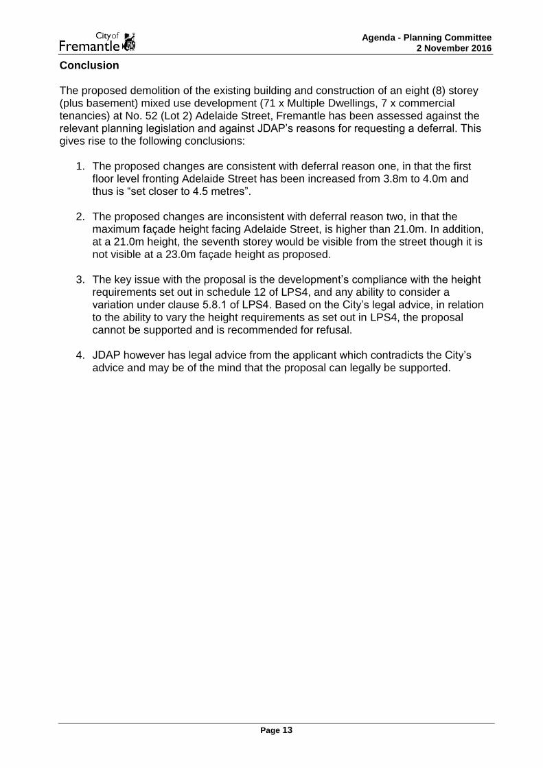
Conclusion The proposed demolition of the existing building and construction of an eight (8) storey (plus basement) mixed use development (71 x Multiple Dwellings, 7 x commercial tenancies) at No. 52 (Lot 2) Adelaide Street, Fremantle has been assessed against the relevant planning legislation and against JDAP’s reasons for requesting a deferral. This gives rise to the following conclusions:
1. The proposed changes are consistent with deferral reason one, in that the first floor level fronting Adelaide Street has been increased from 3.8m to 4.0m and thus is “set closer to 4.5 metres”.
2. The proposed changes are inconsistent with deferral reason two, in that the
maximum façade height facing Adelaide Street, is higher than 21.0m. In addition, at a 21.0m height, the seventh storey would be visible from the street though it is not visible at a 23.0m façade height as proposed.
3. The key issue with the proposal is the development’s compliance with the height
requirements set out in schedule 12 of LPS4, and any ability to consider a variation under clause 5.8.1 of LPS4. Based on the City’s legal advice, in relation to the ability to vary the height requirements as set out in LPS4, the proposal cannot be supported and is recommended for refusal.
4. JDAP however has legal advice from the applicant which contradicts the City’s
advice and may be of the mind that the proposal can legally be supported.

Agenda - Planning Committee 2 November 2016
Page 14
REPORTS BY OFFICERS (COMMITTEE DELEGATION)
The following items are subject to clause 1.1 and 2.1 of the City of Fremantle Delegated Authority Register
PC1611-2 NORFOLK STREET, NO.24 (LOTS 2 & 66), FREMANTLE - DEMOLITION OF EXISTING BUILDING AND CONSTRUCTION OF A FOUR (4) STOREY MIXED USE DEVELOPMENT (8 MULTIPLE DWELLINGS & 1 OFFICE) - (BP DA0350/16)
ECM Reference: 059/002 Disclosure of Interest: Nil Meeting Date: 2 November 2016 Responsible Officer: Acting Manager Development Approvals Actioning Officer: Planning Officer Decision Making Level: Planning Committee Previous Item Number/s: PC1607 – 13 January 2016 Planning Committee Attachments: 1: Development Plans
2: Site Photos 3: Additional justification from applicant 4: State Heritage Office Advice 5: Internal Heritage Comment 6: Fremantle Ports Authority Advice
Date Received: 18 July 2016 Owner Name: Mayland Nominees Pty Ltd Submitted by: Brooking Design Architects Scheme: City Centre Heritage Listing: Level 3 Existing Landuse: Shop Use Class: Office and Multiple Dwelling Use Permissibility: P & D

Agenda - Planning Committee 2 November 2016
Page 15
EXECUTIVE SUMMARY The application seeks planning approval for the demolition of an existing heritage listed building and the construction of a four (4) storey Mixed use development (8 Multiple dwellings and Offices). The proposal is referred to the Planning Committee (PC) due to a number of submissions that are unable to be addressed through the imposition of planning approval conditions, as well as the requirement for Design principle assessments against requirements of the Residential Design Codes (R-Codes), and discretionary assessments Local Planning Scheme No. 4 (LPS4) and Local Planning Policies (LPPs) including:
Building height
Outdoor living areas
Onsite vehicle parking
Design of car parking spaces
Dwelling size
Visual Privacy
Utilities and facilities The City’s Heritage services and the State Heritage Office (SHO) consider the demolition of the existing building onsite to be acceptable, and the City’s Design Advisory Committee generally support the proposal; however the discretion relating to building height is not considered supportable against the criteria of Schedule 12 of LPS4. Accordingly the proposed development is recommended for refusal. BACKGROUND
No. 24, (Lots 2 & 66) Norfolk Street, Fremantle (subject site) are zoned ‘City Centre’ in accordance with LPS4. The subject site has been identified by the City’s Municipal Heritage Inventory (Management Category Level 3) as a place of cultural heritage significance and subsequently adopted under the City’s Heritage List. The site is located within the West End Conservation Area which is a designated Heritage Area under LPS4. The subject site encompasses a total lot area of approximately 240m² and is of a north-west (rear) to south-east (front) orientation. The site is improved by an existing single storey building (circa 1940). Adjacent to the subject site (north east) is No. 26 - 28 Norfolk Street, Fremantle, which is adopted under the Heritage Council of Western Australia’s State Register of Heritage Places.

Agenda - Planning Committee 2 November 2016
Page 16
There are also a number of places of cultural heritage significance on Norfolk Street which are included on the City’s Heritage List. These properties include:
Numbers 8, 12-14, 16 and 24 Norfolk Street
Numbers, 22 and 26-28 Norfolk Street which immediately abut the subject site and represent Fremantle housing dated from 1865 to c1940
The Norfolk Island Pine trees within the street verge
The limestone features at No. 38 Norfolk Street Relevant site history includes:
On 14 December 2011, the City refused planning approval for a three storey addition and alterations and a change of use to Restaurant (Café) or Commercial to Existing Building (DA0444/11). This refusal was formed on the basis that the proposal did not conserve and enhance a place of heritage significance.
On 14 December 2011, the City refused planning approval for the demolition of the heritage building (DA0148/11).
On 21 January 2016, the City granted planning approval for the demolition of the existing building and construction of a three (3) storey Mixed use development (Office and 6 Multiple Dwellings).
DETAIL
On 18 July 2016, the City received a development application (DA0350/16) for the demolition of the existing building and construction of a four (4) storey Mixed use development including:
A commercial space on the ground floor designated as being used for either Office or Shop
8 Multiple Dwellings including:
o 2 Units consisting of two bedrooms, two bathrooms, kitchen, dining and
living areas, and a balcony
o 6 Studio Units consisting of one bedroom, one bathroom, a kitchen and
living area, and a balcony The proposed development is to incorporate a maximum external wall height of 12.3m at the rear fourth storey element and 8.7m at the three storey addition on the street elevation. The applicant has provided supporting documentation in the form of planning assessment reports (Attachment 3). Refer to Attachment 1 for development plans.

Agenda - Planning Committee 2 November 2016
Page 17
STATUTORY AND POLICY ASSESSMENT The proposal has been assessed against the relevant provisions of LPS4, the R-Codes and Council’s local planning policies. Where a proposal does not meet the Deemed-to-comply requirements of the R-Codes, an assessment is made against the relevant Design principle of the R-Codes. Not meeting the Deemed-to-comply requirements cannot be used as a reason for refusal. In this particular application the areas outlined below do not meet the Deemed-to-comply criteria of the R-Codes, LPS4 requirements or local planning policy (LPP’s) provisions and need to be assessed under the relevant Design principles or Discretionary criteria of LPS4 or Council’s Local Planning Policies (LPP):
Building height Outdoor living areas Onsite vehicle Parking Design of car parking spaces Dwelling size Visual privacy Utilities and facilities
The above matters are discussed in detail in the ‘Planning Comment’ section below. CONSULTATION
State Heritage Office (SHO)
The original proposal was referred to the SHO as the site abuts a building included on the State Heritage Register. The following comments were received.
Findings
The plans indicate that the design has been revised so that the new development at 24 Norfolk Street has a new fourth level comprising roof terrace to the forward section and studio units to the rear. The setback and distance to the adjacent property remain the same.
The proposal is not considered to have any further impact on the cultural significance of Houses, 26-28 Norfolk Street.
Advice Based on the comments provided above, we can confirm that we do not have any objection to the proposed development on the condition that a Dilapidation Survey of 26-28 Norfolk Street is prepared by an appropriately qualified professional and submitted to the State Heritage Office prior to the application for a Building Permit. Refer to Attachment 4 for full copy of SHO advice.

Agenda - Planning Committee 2 November 2016
Page 18
Fremantle Ports
The application was referred to Fremantle Port authority (FPA), given that the subject site is located within Area 2 of the Fremantle Port Buffer, and the following comments were provided:
The requirements of the City’s Local Planning Policy 2.3 – Port Buffer Area Design Guidelines (LPP 2.3) for Area 2 will be applicable to the development; specifically in regard to the built form of the development and the registration of a notification or memorial on the title of the subject lot. It would be appreciated if these requirements could be included as conditions of approval.
Planning Committee is advised that should they elect to approve the application, conditions of approval should be applied as per Fremantle Ports’ advice. Refer to Attachment 6 for a full copy of the Fremantle Ports submission.
Internal Referrals
Design Advisory Committee (DAC)
The proposal was presented to the City’s DAC meeting on 12 September 2016 as a requirement of Local Planning Policy 1.9 – Design Advisory Committee and Principles of Design, where the following comments were made in respect to the proposal:
CABE DESIGN PRINCIPLES
CHARACTER
DAC recognises proximity to heritage listed buildings, particularly state listed property to north-east. Importance of materials and finishes to boundary walls is therefore important. It was noted that bulk and scale could be a problem on the south-western courtyard edge to the property on the north-east.
Continuity and Enclosure
Concerns over the dimensional characteristics, particularly of the studio units. Discussion included removal of the narrow balconies fronting ROW for studio units and their depth then incorporated into the length of the units. With provision of windows that fold back, an ‘open room’ could be created which would assist with adding area and a sense of space to those units. Concerns also regarding size of internal rooms of all units (bedrooms, living room, kitchen).
QUALITY OF PUBLIC REALM
The above issues did not arise during the presentation.
Ease Of Movement
The above issues did not arise during the presentation.
Legibility, Adaptability, Diversity

Agenda - Planning Committee 2 November 2016
Page 19
The above issues did not arise during the presentation.
OVERALL DESIGN QUALITY AND FUNCTIONALITY
1. Concerns over the dimensional characteristics of living rooms and bedrooms, reducing amenity of those units;
2. Concern over kitchen dimensions – lack of preparation space/area; 3. Project would be improved by introducing glazing to the wall between the
stairwell and the proposed communal roof deck/garden. APPROPRIATENESS OF MATERIALS AND FINISHES Concern over the quality and durability of the proposed stained finish to the concrete side walls. This should be further tested and alternative concrete finishes, such as sandblasting, explored. GENERAL COMMENTS Not considered design excellence in its current form. It is noted that this is not required in order to obtain discretionary height. DESIGN ASSESSMENT WHAT ARE THE STRENGTHS 1. With the proposed height adjustments, including lowering of height to the street
edge, the four storey building was considered an acceptable design outcome relative to the three storey building already approved;
2. Roof top communal garden is a good concept, but currently lacks design detail and requires further refinement
HOW CAN THE PROPOSAL BE IMPROVED See above comments in the design principle assessment. RECOMMENDATION Prior to the issue of a Building Permit, the applicant shall submit the following information to the satisfaction of the Chief Executive Officer – City of Fremantle, having regard to advice from the Design Advisory Committee: a) Additional detail relating to colour, texture and material arrangement for final
facade finishes, particularly currently proposed stained concrete on the side walls,
b) Glazing be introduced to street elevation of the 4th floor stairwell located at the rooftop terrace to increase light to stairwell of the building,
c) Screening of air conditioning condensers, d) Introduction of internal storage (robes) for bedrooms, e) Grading of entry to car parking to allow removal of the current proposed stairs
linking the car park to the lobby area , f) Provision of skylights to 4th level dwellings to increase light/ventilation to internal
habitable spaces,

Agenda - Planning Committee 2 November 2016
Page 20
g) Additional detail for proposed communal roof top garden which will improve amenity for the residents and help provide presence to the street.
As the proposal has been recommended for refusal, the above condition is not included in the officer’s recommendation.
Heritage Services
A heritage assessment of the proposed development was required to be undertaken in accordance with L.P.P. 1.6 Preparing Heritage Assessments as the property is identified and adopted by the City’s Heritage List and Municipal Heritage Inventory as a Management Category Level 3. The following recommendation has been provided:
Overall, the proposed development is considered acceptable on heritage grounds with the following conditions:
Prior to the commencement of development that further details are provided of the proposed façade and approved by the Chief Executive Officer, City of Fremantle;
Following investigation of the original mortar and render method and materials and prior to the commencement of proposed conservation works to the boundary wall to 26-28 Norfolk Street that further details are provided and approved by the Chief Executive Officer, Fremantle;
That the proposed gate between 24 Norfolk Street and 26-28 Norfolk Street is not attached to the heritage building;
Prior to commencement of the development an archaeological investigation of the subject site shall be undertaken at the applicant’s expense in accordance with Clause 7.7.3 of Local Planning Scheme No. 4. The findings of this investigation including a report shall be submitted to the satisfaction of the Chief Executive Officer of the City of Fremantle.
An archival record will be prepared and submitted to the City of Fremantle for approval before the commencement of any works. The archival record should consist of the following:
• Measured Drawings
The measured drawings should be sketch standard, freehand drawings will be accepted provided they are neat and clearly presented. All drawings should be approximately to scale, with key dimensions shown.
• Site plan (1:500 or 1:200) • Floor plan/s (1:100 or 1:50)
All documents are to be of A4 size or folded into A4 size. • Photographs
Digital photographs are to be taken of the building (once vacated). Photographs are to be in colour, of a high quality, and are to show the current state of the place. Each image should be clearly labelled, with a description of what is depicted in the photograph and the date it was taken. The photographs are to include:
(i) a general/overall photograph of the building to be demolished, showing its setting including the streetscape;

Agenda - Planning Committee 2 November 2016
Page 21
(ii) photographs of the four external facades, all rooms and any special architectural features;
(iii) the plans are to show the position, direction and number of each photograph.
Note: It is recommended that for the next City of Fremantle review of the Heritage List and Municipal Heritage Inventory (MHI) that the 24 Norfolk Street be removed from the Heritage List and be updated and retained on the MHI for historic purposes.
Refer to Attachment 3 for a full copy of the internal heritage assessment.
Parks and Landscape Services
The proposal was referred to the City’s Parks and Landscape Management services due to the proximity of a large Norfolk pine tree to the subject site. The following comments were made in relation to the proposal:
No excavation (is) to occur on the verge around the mature Norfolk pine during building works. If the need arises that excavation work is required on the verge, Council officer to be onsite to observe works. Any minor limb reduction over the property requires Council approval and Council to undertake.
An advice note is recommended to be provided to inform the applicant of this requirement, in the event the application is granted planning approval.
Community
The application was required to be advertised in accordance with Clause 9.4 of the LPS4, due to a number of discretions being sought. At the conclusion of the advertising period, being 29 August 2016, the City had received 17 submissions, with 14 raising objections. The following planning concerns (summarised) were raised:
The addition of a fourth storey sets an undesirable precedent for the surrounding area.
The additional storey would have an adverse impact on neighbouring properties, particularly the state heritage listed duplex to the north-east (26-28 Norfolk Street).
The terrace decking area would facilitate direct overlooking into the outdoor living area of the adjacent property at 26-28 Norfolk Street, thus impacting on visual privacy.
There is insufficient car parking provided on site to appropriately accommodate the number of residents that would be living in the units.
The development would be incongruous with the height patterns of the streetscape of Norfolk Street.
More consideration should be given towards the design of the building and how it relates to surrounding properties.
These concerns are discussed in further detail in the “Planning Comment” section of this report.

Agenda - Planning Committee 2 November 2016
Page 22
PLANNING COMMENT Local Planning Scheme No. 4 Building Height
Element Required Proposed Discretion
External wall height max storeys
11m 3 Storeys
12.3m 4 Storeys
1.3m 1 Storey
The application proposes an external wall height greater than 11 metres and a fourth storey and therefore must be assessed against the discretionary criteria of sub area 1.3.1 of Schedule 12. Sub area 1.3.1 which states as follows and are subsequently considered: Council may consent to an additional storey subject to:
a) the upper level being sufficiently setback from the street so as to not be visible from the street(s) adjoining the subject site,
b) maximum external wall height of 14* metres, and c) compliance with clause 1.2. above.
*inclusive of roof parapet and spacing between floors.
In relation to sub clause a), the development’s fourth floor meets the definition of not being visible from the street as prescribed in LPS4. This is evident in the below provided diagram.
In relation to sub clause b), the external wall height does not exceed 14m as measured from natural ground level and therefore the development is compliant with this clause. With respect to sub clause c), clause 1.2 for Local Planning Area 1 in Schedule 12 of the City’s LPS4, the development is not considered to meet all requirements as follows:
a) that the proposal is consistent with predominant height patterns of adjoining properties and the locality generally,
Agenda - Planning Committee 2 November 2016
Page 23
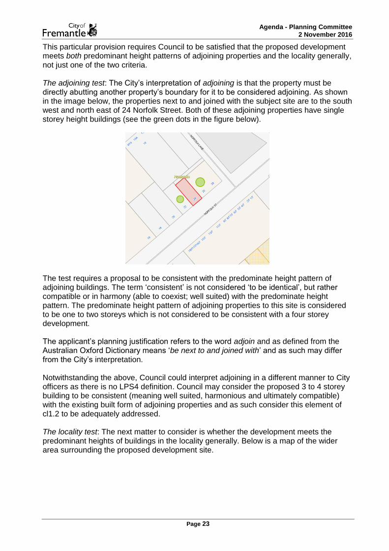
This particular provision requires Council to be satisfied that the proposed development meets both predominant height patterns of adjoining properties and the locality generally, not just one of the two criteria. The adjoining test: The City’s interpretation of adjoining is that the property must be directly abutting another property’s boundary for it to be considered adjoining. As shown in the image below, the properties next to and joined with the subject site are to the south west and north east of 24 Norfolk Street. Both of these adjoining properties have single storey height buildings (see the green dots in the figure below).
The test requires a proposal to be consistent with the predominate height pattern of adjoining buildings. The term ‘consistent’ is not considered ‘to be identical’, but rather compatible or in harmony (able to coexist; well suited) with the predominate height pattern. The predominate height pattern of adjoining properties to this site is considered to be one to two storeys which is not considered to be consistent with a four storey development. The applicant’s planning justification refers to the word adjoin and as defined from the Australian Oxford Dictionary means ‘be next to and joined with’ and as such may differ from the City’s interpretation. Notwithstanding the above, Council could interpret adjoining in a different manner to City officers as there is no LPS4 definition. Council may consider the proposed 3 to 4 storey building to be consistent (meaning well suited, harmonious and ultimately compatible) with the existing built form of adjoining properties and as such consider this element of cl1.2 to be adequately addressed. The locality test: The next matter to consider is whether the development meets the predominant heights of buildings in the locality generally. Below is a map of the wider area surrounding the proposed development site.

Agenda - Planning Committee 2 November 2016
Page 24
The figure above indicates 1 to 4 storey buildings of surrounding properties within the wider area, noting that the meterage height of these storeys does vary. Single storey buildings are approximately up to 4.5m wall height, two storey up to 6 – 8m, three storey 8 -10m and four storey between 10-14m. While there is no definition in LPS4 for locality generally, it is recommended that for the purposes of assessing height, that only the properties in a subject site’s immediate context should be considered. For this proposal, it is considered that the street block the subject site falls in as well as properties directly opposite on Norfolk Street, are considered to form the locality generally. It is clear from the above figure that the predominant height of buildings surrounding the development site are single or double storey, with some reaching three storeys as per the height limits for sub area 1.3.1 in Schedule 12. The above figure is not an indication of what City officers consider to be the locality generally, but it is acknowledged that this may be an alternate interpretation. As shown in the figure above, while City officers do not include the cluster of four storey buildings on Essex and Collie Streets to the north of the site to form part of the locality generally for this assessment, Council could elect to form an alternate interpretation and include these properties. Conclusion: On this basis, it is considered that a four storey building for this site is not consistent with the predominant height patterns of adjoining properties or the locality generally. Whilst acknowledging that one site within Norfolk Street, which could be considered to form part of the locality generally consists of a 3-4 storey building (No.3

Agenda - Planning Committee 2 November 2016
Page 25
Norfolk Street), this site alone is not considered to demonstrate the predominate height pattern. Selectively identifying some buildings which may be three or four storeys is not considered an appropriate methodology to ascertain the predominant height pattern. Therefore, in summary, the proposed building height of four storeys is deemed to be inconsistent with point a) of clause 1.2.
b) the proposal would not be detrimental to the amenity of adjoining properties or the locality,
The existing approved development of a three storey development for the site (refer DA0393/15) includes 9.7m – 10.2m high boundary walls to the northern and southern common boundaries. The proposed four storey development includes 9.8m -12.1m high northern and southern boundary walls. Comparison images of the existing approved and the newly proposed southern and northern elevations of the development are as follows:

Agenda - Planning Committee 2 November 2016
Page 26
Southern elevation comparison

Agenda - Planning Committee 2 November 2016
Page 27
Northern elevation comparison
As set out above, the southern portion of wall would have minimal impact given the neighbouring commercial (Restaurant use) southern property has a building which covers its entire site area. To the rear boundary the adjacent western property consists of hardstand commercial car parking for the property located at No.19 Essex Street, which is also considered to result in minimal adverse amenity impacts to this property.

Agenda - Planning Committee 2 November 2016
Page 28
The property directly to the north-east, being No. 26-28 Norfolk Street, will be directly impacted by the newly proposed additional fourth storey and the proposed rooftop terrace as it would directly abut the exclusive outdoor living area of this residential property. With regards to visual privacy, any such amenity impact could be easily addressed with the imposition of a visual privacy condition (screening devices) if an approval was to eventuate. In terms of the loss of winter sun access or access to direct sunlight, the south western positioning and orientation of the subject site is considered to result in a minimal impact to this property. It is acknowledged that with the additional wall height associated with the proposed fourth storey (approx. 0.9 – 1.9m additional wall height) some building bulk impacts may result. Whilst stating this potential impact, it’s also worth noting that the adjoining site does incorporate several mature trees which would assist in screening the building bulk, restricting the level of impact on this outdoor living area. Overall, the amenity impact resulting from the additional fourth storey is not considered to be significant. Council may consider any additional wall height above the approved three storey building for this site to have a significant amenity impact in terms of building bulk and or loss of solar access to this adjoining property and therefore Council could include this matter as reason to refusal. With regards to the proposal and its ability to be detrimental to the amenity of the locality, given the fourth storey’s significant setback from Norfolk Street, and its limited view from other public spaces within the locality, the proposal is considered to have a negligible impact on the overall amenity of the locality.
c) the proposal would be consistent, if applicable, with conservation objectives for the site and locality generally, and
In relation to the subject site’s heritage significance, as the existing building on site is approved for demolition, any conservation objectives previously considered for the site would be removed.
It is acknowledged however, that there are a number of heritage listed properties in the locality generally and that the site is within the West End Conservation Area Heritage Area. Given the additional storey is setback from the street and that this portion of the development will not immediately abut sensitive areas of heritage listed properties, it is not considered that there would be a detrimental impact on these properties.
d) any other relevant matter outlined in Council’s local planning policies.
Council may impose a lesser height in the event that the proposal does not satisfy any of the above requirements.
In relation to point d), Council’s Local Planning Policy D.G.F14 - Fremantle West End Conservation Area Policy has some provisions that are of relevance to the proposed development being considered at 24 Norfolk Street. In Zone 3 defined in the policy, which is the area bounded by Collie Street, Marine Terrace, Norfolk Street and South Terrace, the policy states the following pertinent objective for proposed development within Zone 3:

Agenda - Planning Committee 2 November 2016
Page 29
In considering residential development proposals, the Council will ensure that those developments conform in general to the existing traditional patterns, and in particular:
i. The scale not to exceed two stories.
While regard is given to the overall objectives of the policy, in the instance a local planning policy is inconsistent with a Scheme provision (i.e. in this instance building height), clause 2.3.1 of LPS4 requires the Scheme provision to prevail. As it has been determined that the proposed development does not meet all of Schedule 12 requirements for the fourth storey, the opportunity arises for an assessment against clause 5.8.1 (variation to height requirements) of LPS4. The trigger for this clause is the existence of buildings adjacent to the development site that depict buildings of a height greater than specified in Schedule 12. As discussed above, the nearest four (4) storey building is 100m away from the subject site and is read in a different context to the proposed development site. It is therefore considered that the proposed development does not meet the minimum requirements, for a clause 5.8.1.1 assessment and the building height of the development is therefore not supported. Clause 5.15 Demolition of Buildings and Structures As detailed in the comments provided by SHO and the City’s internal heritage services, the proposed demolition is considered to be supportable on heritage grounds, given that the existing building is determined to be of ‘limited’ significance. Furthermore, the current building, as stated in the heritage comment, is not considered to make a significant contribution to the broader cultural heritage significance and character of the locality in which it is located. Further detail is included in the City’s heritage assessment and SHO’s comments which are attached to this report. On the basis of the above, the proposed demolition is considered to satisfy clause 5.15.1 of LPS4, and therefore the demolition is deemed to be supportable. Residential Design Codes 6.3.1 – Outdoor living areas (balcony)
Element Deemed-to-comply Provided Design principle
Assessment
Area Minimum of 10m² with a minimum dimension of 2.4m
3.84m² - 17m2, minimum
dimension of 1.2m (Studio Units) –
2.0m (2 bedroom units)
Up to 6.16m² and 0.4 - 1.2m minimum
dimension

Agenda - Planning Committee 2 November 2016
Page 30
The proposed outdoor living areas are considered to be supportable for the following reasons:
The balconies afforded to the studio units are capable of use in conjunction with a habitable room of the dwelling, given that the outdoor living area is to be directly accessible from the living room and kitchen spaces.
The balconies to the studio units are oriented towards the north and as such, allow for the infiltration of winter sun throughout the dwellings.
6.3.3 – Parking
Element Deemed-to-comply Provided Design principle Assessment
Multiple Dwellings 10 (8 dwellings 2 visitors)
2 6
Office 3 0 3
The proposed car parking allocation is considered to be supportable for the following reasons: The office and residential car parking provision is supported under clauses 5.7.3.1 (a) (i) and (ii) of LPS4, as well as clause 6.3.3 of the R-Codes.
The subject site is located within close proximity to the ‘CAT’ bus service on South Terrace, situated approximately 619m from the Fremantle train station, and has numerous nearby car parking sites, including, but not limited to:
o The Henderson Street (Queensgate) parking facility, which contains 850
bays, is 250 metres from 24 Norfolk Street
o Parking at the corner of Marine Terrace and Norfolk Street
o Fremantle Hospital parking
There is considered to be a sufficient number of on-street spaces that are available near the development. Furthermore, there is considered to be adequate car and bicycle parking, taking into account the type, number and size of the dwellings proposed, as well as the proximity to numerous public transport options to the subject site.
It is additionally noted that the application complies with the bicycle parking provision by providing a bike rack to accommodate twelve bicycles.
A study conducted by Luxmoore in 2012 found that there were 944 car parking bays available for public use within Precinct 6, in which Norfolk Street is located. However, it is noted that out of these 944 public car parking bays, only 7% (66), at the time of the study, were vacant at peak demand.

Agenda - Planning Committee 2 November 2016
Page 31
6.3.4 – Design of car parking spaces
Element Deemed-to-comply Provided Design principle Assessment
Manoeuvring space For a car bay width of 2.4m – ‘apron’ width of 7m (as per AS.2890.1).
6.3m
0.7m
The proposed manoeuvring space is considered to be supportable for the following reasons:
The car parking manoeuvring space provided is considered to provide an adequate space for vehicles to enter and exit, albeit with an increased number of turns. However, the required number of turns is still deemed to provide convenient, accessible and secure parking for residents. In addition, the increased garage width space to either side of the bays allows for flexibility in manoeuvring, in that vehicles are able to adjust the movement of the turning circle with less of an impediment than if the opening was narrower.
The car parking facilities are to have a negligible impact on the streetscape, given that the proposed garage is to be constructed at the rear of the site.
6.4.3 – Dwelling size
Element Deemed-to-comply Provided Design principle Assessment
Minimum plot ratio area for each dwelling
40m²
32.25m² for the Studio Dwellings
(excluding balconies)
7.75m²
The proposed dwelling size for the studio dwellings is considered to be supportable for the following reasons:
Each dwelling within the development is considered to be of a sufficient size to cater for the needs of residents. Whilst it is acknowledged that the size of the studio dwellings is, in comparison to the two bedroom dwellings, significantly more confined the dwellings are still able to provide essential facilities such as a kitchen, bathroom and a living area.
The development proposes 8 Multiple dwellings, with two of these being two bedroom dwellings and the remainder being studio dwellings. Taking into account the overall size of the development, such a level of diversity is considered to provide a reasonable range of dwellings types and sizes.

Agenda - Planning Committee 2 November 2016
Page 32
6.4.1 - Visual privacy
Element Deemed-to-comply Provided Design principle Assessment
Visual Privacy Setback (north-east)
6m setback 1.2m setback 4.8m
The proposed visual privacy setback to the north-eastern property is not considered to be supportable for the following reason:
The setback would facilitate direct overlooking into the only outdoor living area for the adjoining residential property at 26-28 Norfolk Street to the north-east. On this basis there is considered to be an adverse impact on the amenity of this property by way of visual privacy. In circumstances such as this, where an application might be otherwise approvable, a condition to provide an appropriate form of screening to negate this overlooking is often included.
6.4.6 – Utilities and facilities
Element Deemed-to-comply Provided Design principle Assessment
Lockable storage area Accessible from outside the dwelling,
with a minimum dimension of 1.5m and at least 4m².
Not accessible from outside the
dwelling, minimum
dimension of 1.05m and a
1.44m².
0.45m, not accessible from
outside the dwelling and 2.66m².
The proposed storage areas are considered to be supportable for the following reasons:
The storage areas provided on the balconies for each are considered to provide a sufficient space for the residents, despite not being accessible from outside the dwelling.
The location of the storage areas is deemed to be both secure and convenient for residents to access.
The storage areas are incorporated into the balconies in such a way so as to be partially screened from view when positioned outside the dwelling. CONCLUSION The proposal has been assessed against the relevant provisions of LPS4, R-Codes and Council’s LPPs and is not considered to be supportable due to the additional building height being sought.

Agenda - Planning Committee 2 November 2016
Page 33
Specifically, the building height proposed is not considered to meet the discretionary criteria in Sub Area 1.3.1 of Schedule 12 of LPS4, as the development is not considered to be consistent with the predominant height patterns of adjoining properties and the locality generally. STRATEGIC IMPLICATIONS The proposal is considered to be consistent with the City’s following strategic documents: Strategic Community Plan 2015-25:
Increase the number of people living in Fremantle
Increase the number of people working in Fremantle
Increase in commercial development within 800m of Fremantle train station.
Increase the net lettable areas of office space
Protect current tree canopy cover in Fremantle
Provide for and seek to increase the number and diversity of residential dwellings in the City of Fremantle
Increase the number of additional dwellings provided in the city centre
OFFICER'S RECOMMENDATION
That the application be REFUSED under the Metropolitan Region Scheme and Local Planning Scheme No. 4 for the demolition of the existing building and construction of a four (4) storey Mixed Use development (8 Multiple dwellings and 1 Office) at No. 24 (Lot 66) Norfolk Street, Fremantle, as detailed on plans dated 18 July 2016, for the following reason: 1. The proposal is inconsistent with Schedule 12, Sub area 1.3.1 – West End in the
City’s Local Planning Scheme No. 4, as the development is not considered to be consistent with the predominant height patterns of adjoining properties and the locality generally.

Agenda - Planning Committee 2 November 2016
Page 34
PC1611-3 MARINE TERRACE, NO. 88 (LOT 3), FREMANTLE - ADDITION OF EXTERNAL STAIRCASE TO EXISTING BUILDING - (CJ DA0401/16)
ECM Reference: 059/002 Disclosure of Interest: Nil Meeting Date: 2 November 2016 Responsible Officer: Acting Manager Development Approvals Actioning Officer: Acting Coordinator Statutory Planning Decision Making Level: Planning Committee Previous Item Number/s: Nil Attachments: 1 -Development Plan Date Received: 12 August 2016 Owner Name: Abigail Santos Submitted by: As above Scheme: Mixed use (R35) Heritage Listing: Not listed Existing Landuse: Multiple dwelling (as part of Mixed use development) Use Class: Multiple dwelling Use Permissibility: A
EXECUTIVE SUMMARY The City has received an application for the addition of an external staircase to an existing building at No. 88 Marine Terrace, Fremantle. The application is seeking Design principle assessment against the Residential Design Codes (R-Codes) for Lot boundary setbacks and Visual privacy. As an objection has been received that cannot be resolved via the imposition of planning conditions, the application is referred to Planning Committee for determination.

Agenda - Planning Committee 2 November 2016
Page 35
After consideration of the application, it is considered that the external staircase will not have a significant adverse impact on adjoining landowners and/or occupiers, and is recommended for on balance conditional approval. BACKGROUND
No. 88 Marine Terrace is located within sub area 4.3.2 of the Fremantle South Local Planning Area in Fremantle. The site is zoned Mixed Use with a base density code of R35. The site is located on the eastern side of Marine Terrace, between Howard and Russell Streets. The site is not Heritage Listed or within a Heritage Area and has a total site area of 433sqm. Relevant planning history for the site is as follows:
17 May 2013 – Retrospective planning application for unauthorised alterations to partly completed three storey Mixed Use development – Approved - DA0624/12.
12 March 2010 - SAT Matter (Reconsideration of deemed refusal) – Proposed Mixed Use Development – Approved - DA52/08.
DETAIL
The City received an application for the addition of a staircase to the south eastern corner of an existing building at No. 88 Marine Terrace, Fremantle on 15 August 2016. The applicant has advised that the staircase is proposed in this location for the following reasons:
There is no exit to the rear in case of an emergency which, in hindsight, was an oversight which should have not been omitted from the original plans.
The City has received revised plans (dated 18 October 2016) from the applicant that demonstrates the staircase’s interaction with the existing ground level parking bays and included screening on the stairwell. Revised development plans are included as Attachment 1. STATUTORY AND POLICY ASSESSMENT
The proposal has been assessed against the relevant provisions of LPS4, the R-Codes and relevant local planning policies. Where a proposal does not meet the Deemed-to-comply requirements of the R-Codes, an assessment is made against the relevant Design principles of the R-Codes. Not meeting the Deemed-to-comply requirements cannot be used as a reason for refusal. In this particular application the areas outlined below do not meet the Deemed-to-comply or policy provisions and need to be assessed under the Design principles:
Lot boundary setbacks
Visual privacy The above matters are discussed in detail in the ‘Planning Comment’ section below.

Agenda - Planning Committee 2 November 2016
Page 36
CONSULTATION
Internal Referrals
Infrastructure Services The City’s has confirmed that the bay dimensions of the rear ground floor bay impacted by the staircase proposal does meet the Australian Standards for a small bay; however as it does not meet the height clearance for the full length of this bay, it should not be used as a car bay. Building Services The City’s Building Surveyor has reviewed the proposal, and has advised the following:
A building permit will be required for the proposed works.
There may be potential fire protection issues with the existing external wall less than 3m from the boundary, and door being cut into the wall.
The stairs will need to be assessed, with regard to exit travel distance, plus also fire separation.
An appropriate advice note is recommended to remind the applicant of their obligations under building legislation.
Community
The application was required to be advertised in accordance with Clause 9.4 of the LPS4, as the proposed staircase did not meet all Deemed-to-comply criteria of the R-Codes. At the conclusion of the advertising period, being 9 September 2016, the City had received one (1) submission. The following issues were raised (summarised):
Privacy issues have been fought by neighbours previously The existing development has resulted in a loss of amenity for the neighbours Adjoining landowners have previously spent a lot of time with Council to mediate
with developer Addition of stairs will impact privacy and amenity Application should be refused as will not meet previous agreements
PLANNING COMMENT
Lot boundary setbacks (boundary walls)
Deemed to comply Proposed Design principle assessment
East – 1m 190mm 810mm
South – 1.1m 190mm 910mm

Agenda - Planning Committee 2 November 2016
Page 37
The proposed staircase is not considered to have a significant impact on the amenity of adjoining properties for the following reasons:
The staircase is an open structure, with solid elements of screening that do rise 1.6m above the finished floor level.
Given existing site levels and retaining walls, the top of the proposed screening on the stairs sits at approximately 2m above boundary fencing at its highest point.
Access to winter sunlight will not be restricted by the proposed staircase, given the shadow already thrown by the three storey building onsite.
As the base of the staircase is open, the impact on ventilation is not considered excessive.
The staircase is to the rear of the property and will not impact the streetscape. It is noted that to satisfy visual privacy requirements for the doorway that leads from the existing balcony, the applicant has provided revised plans that provide screening on the entire southern elevation of the staircase. To reduce building bulk on the neighbour, Planning Committee could elect to reduce the size of the proposed screening or delete the screening, given there will only be an impact when the doorway is open. The following condition is provided for Committee’s consideration:
The screening on the staircase approved as part of DA0401/16 on plans dated 18 October 2016 are hereby deleted from the plans and do not form part of this approval.
Parking One of the previously approved car parking bays, marked as Residential on the originally approved plans, will be affected by the proposed addition of the staircase. The applicant has advised that this meets the Small Bay provisions of the Australian Standard; however there is an incursion into this bay for a portion of its length. The City has reviewed the proposal and advised that a 2.2m height clearance is required for the full length of a bay, even when being proposed as a small car bay. For these reasons, the bay is conditioned to be deleted. Due to changes in the R-Codes from the time when the original Mixed use development was approved, the overall number of car bays required on site has reduced for Multiple Dwellings. With the deletion of this bay, the overall development will still meet Deemed-to-comply requirements of the current R-Codes for onsite resident parking bays. STRATEGIC IMPLICATIONS The proposal is consistent with the City’s following strategic documents:
Not applicable

Agenda - Planning Committee 2 November 2016
Page 38
ALTERNATE OFFICERS RECOMMENDATION Whilst City officers recommend conditional approval for the development, should Planning Committee consider the building bulk impact from the reduced lot boundary setback of the staircase to be significant, the following alternate recommendation is provided: That the application be REFUSED under the Metropolitan Region Scheme and Local Planning Scheme No. 4 for the external staircase addition to existing Mixed use building at No. 88 (Lot 3) Marine Terrace, Fremantle, for the following reason: 1. The proposal does not address the Design principle criteria of the Residential
Design Codes in respect to the southern lot boundary setback of the external staircase addition.
OFFICER'S RECOMMENDATION That the application be APPROVED under the Metropolitan Region Scheme and Local Planning Scheme No. 4 for the external staircase addition to existing Mixed Use building at No. 88 (Lot 3) Marine Terrace, Fremantle, subject to the following condition(s):
1. This approval relates only to the development as indicated on the approved plans, dated 18 October 2016. It does not relate to any other development on this lot and must substantially commence within four years from the date of this decision letter.
2. Prior to use of the external stairs and doorway approved as part of
DA0401/16, on plans dated 18 October 2016, the doorway located on the first floor southern elevation of the existing balcony, shall be screened in accordance with Clause 5.4.1 C1.1 of the Residential Design Codes by either:
a) fixed obscured or translucent glass to a height of 1.60 metres above
floor level, or b) fixed with vertical screening, with openings not wider than 5cm and
with a maximum of 25% perforated surface area, to a minimum height of 1.60 metres above the floor level, or
d) an alternative method of screening approved by the Chief Executive Officer, City of Fremantle.
The required screening shall be provided and maintained to the satisfaction of the Chief Executive Officer, City of Fremantle.
3. Prior to use of the staircase as approved in DA0401/16 on plans dated 18
October 2016, the car bay in the south eastern corner on the ground floor of the development, shall be deleted and appropriate barriers installed to prevent use.

Agenda - Planning Committee 2 November 2016
Page 39
Advice notes:
i. A Building Permit is required for the proposed Building Works. A certified BA1 application form must be submitted and a Certificate of Design Compliance (issued by a Registered Building Surveyor Contractor in the private sector) must be submitted with the BA1.

Agenda - Planning Committee 2 November 2016
Page 40
PC1611-4 COLLEGE CORNER, NO.25 (LOT 108), O'CONNOR - CHANGE OF USE TO HOME BUSINESS (WAREHOUSE) - (NB DA0471/16)
ECM Reference: 059/002 Disclosure of Interest: Nil Meeting Date: 2 November 2016 Responsible Officer: A/Manager Development Approvals Actioning Officer: Planning Officer Decision Making Level: Planning Committee Previous Item Number/s: PC1604-9 Attachments: 1: Minutes of PC Committee – 6 April 2016
2: Development Plans 3: Applicant’s Response to Submissions 4: Site Photos
Date Received: 16 September 2016 Owner Name: Chi Wai Cheung & Kam Fung Mo Submitted by: As above Scheme: Development Area 8 (Residential - R30) Heritage Listing: Not listed Existing Landuse: Single House Use Class: Home Business Use Permissibility: ‘A’

Agenda - Planning Committee 2 November 2016
Page 41
EXECUTIVE SUMMARY
The application seeks planning approval for the renewal of a Home Business for the purposes of storage in an existing Single House at No. 25 (Lot 108) College Corner, O’Connor. Planning approval was granted for a Home Business (Storage) use, but as part of this Council approval the land use approval expired 11 October 2016. This application seeks additional planning approval to continue the previous approved land use onsite. The applicant seeks an assessment against the definition of a Home Business in the City’s Local Planning Scheme No. 4 (LPS4) in regards to its impact on the amenity of the neighbourhood, which is considered to satisfy the definition and is therefore supported. The application is recommended for conditional approval. BACKGROUND
On 6 April 2016, the Planning Committee issued retrospective approval for a Home Business (Warehouse), subject to the following conditions:
1. This approval relates only to the development as indicated on the approved plans, dated 26 November 2015. It does not relate to any other development on this lot.
2. This approval allows the Home Business hereby permitted to be conducted by Chi Wai Cheung and Kam Fung Mo. If Chi Wai Cheung and Kam Fung Mo cease to operate the Home Business hereby permitted or occupy the subject site, this approval will expire.
3. The deliveries associated with the Home Business hereby permitted shall only occur between 9am to 4pm Monday to Friday.
4. The Home Business consisting of storage of goods for the purpose of sale hereby permitted shall not occupy an area of greater than 50sqm.
5. This approval is limited to a period of 6 months from the date of planning, approval. A separate planning approval will be required to continue the operation of the Home Business (Warehouse) after this time.
The full report and minutes of the PC Committee meeting of 6 April 2016 are included as Attachment 1 and a brief summary is as follows: In August 2015, the City received complaints from adjoining neighbours that the subject site was being used as a warehouse with frequent deliveries from large trucks and at least one sea container. City officers inspected the premises and discovered that the garage, the side patio and rear shed were being used for the storage of goods, though these goods were not being sold on the premises. Officers advised the owners to submit an application for retrospective approval, which they did in December 2015. During the advertising period, five (5) submissions were received objecting to the size of the warehouse component and the scale of the activities carried out as having a negative impact on the amenity of the neighbourhood. As a result, the owners were instructed to

Agenda - Planning Committee 2 November 2016
Page 42
reduce the amount of floor space used for storage to a maximum of 50m2 in order to comply with the definition of a ‘Home Business’ as defined in Schedule 1 of LPS4 prior to the application being referred to Council. The owners complied with all instructions by confining the storage space used for the purposes of the business to 50m2 within the garage and limiting delivery hours. Planning Committee subsequently granted a temporary (6 month) planning approval to see if allowing the business to operate in a much reduced capacity and under conditional approval would still have a negative impact on neighbour amenity. The specified term of approval has now lapsed and the owners are seeking a permanent approval to continue the Home Business (Warehouse) use on site. Within the 6 month approval period of this use onsite, the City has not received any further complaints regarding the Home Business operations.
DETAIL
The application seeks a renewal of planning approval for a Home Business (Warehouse) for the storage of goods operating from a Single House at No. 25 College Corner, O’Connor. The current plans are identical to those previously approved and consist of a garage converted into a storage area with a maximum 50m2 being used to store goods for the business. A copy of the development plans is included as Attachment 2. STATUTORY AND POLICY ASSESSMENT
The proposal has been assessed against the relevant provisions of LPS4 and relevant local planning policies and the development seeks assessments relating to the definition of a Home Business in Schedule 1 of LPS4. The above matters are discussed in detail in the Planning Comment section below. CONSULTATION
Community
The application was required to be advertised in accordance with Clause 9.4 of the LPS4, as a Home Business is a discretionary land use. At the conclusion of the advertising period, being 12 October 2016, the City had received 1 submission. The following issues were raised (summarised):
Objection to the increase of deliveries, including small trucks and sea containers, at all hours of the day, sometimes as early as 6am.
The amount of storage of cardboard throughout the garage and in the rear is a health hazard and attracts vermin.
Vehicles unload near the bedroom of the adjoining house, which can cause a disturbance.
This is a warehouse facility which cannot be properly policed in terms of the amount stored at any one time.

Agenda - Planning Committee 2 November 2016
Page 43
The applicant’s response to the above submission is included as Attachment 3. PLANNING COMMENT
At the close of advertising for the original application for the unauthorised Home Business use in early 2016, five (5) submissions were received from adjoining residents and there was wide agreement that the unauthorised use of the premises as essentially a large warehouse adversely impacted the amenity of the neighbourhood. In comparison, after six months of operating under Council’s conditional approval the current application received one (1) submission. Further, no complaints have been received from neighbouring residents regarding the operation of the approved Home Business since Council granted approval. This would seem to indicate that the Home Business has been operating within the parameters of their planning approval, and the conditions imposed greatly reduced the negative impact on residential amenity. As per Schedule 1 of LPS4, a Home Business is defined as:
a business, service, or profession carried out in a dwelling or on land around a dwelling by an occupier of the dwelling which —
a) does not employ more than 2 people not members of the occupier’s household, b) will not cause injury to or adversely affect the amenity of the neighbourhood, c) does not occupy an area greater than 50 square metres, d) does not involve the retail sale, display or hire of goods of any nature, e) in relation to vehicles and parking, does not result in traffic difficulties as a result
of the inadequacy of parking or an increase in traffic volumes in the neighbourhood, and does not involve the presence, use or calling of a vehicle more than 3.5 tonnes tare weight, and
f) does not involve the use of an essential service of greater capacity than normally required in the zone.
The proposal complies with (a), (c), (d) and (f) above. The outstanding issues are the impact on the amenity of the neighbourhood and the impact on traffic volumes. The storage of goods has been confined entirely to a 50 m2 area within the existing garage. In relation to required residential onsite car parking, the entire front setback area of the existing dwelling is paved and adequately accommodates the required onsite vehicle parking for the existing dwelling. Further, all sales occur off the premises and the goods stored consist primarily of hats and other clothing accessories. No food or perishable goods are stored on-site for the purposes of this Home Business application. In those respects, the development is likely to continue to have minimal impact on the amenity of the neighbourhood and is therefore supported. In relation to traffic and vehicle deliveries, no issues have been brought to the City’s attention in the six months since the Home Business was granted temporary approval. However, this issue was raised as a concern during the community consultation period for this application. The concern received doesn’t elaborate as to the number of deliveries or time periods such delivers occur, but rather a nuisance complaint as to the location and disturbance the deliveries to the site have had on existing bedroom areas of the neighbouring dwelling. Restricting an area onsite to delivery services is considered

Agenda - Planning Committee 2 November 2016
Page 44
problematic given the limited options available to the site, although Council may consider it appropriate to limit the hours of the day deliveries can come to the site, which may alternatively assist with negating this conflict and potential amenity impact. An appropriate condition is included as part of other Officer’s recommendation. Prior to the previous approval, a sea container was used once to deliver goods but with no indication from adjoining owners (other than the single submission) that one has been used since. Notwithstanding, provided the container was located entirely within the boundary of the property and for a period not exceeding 14 days, it would have been considered a temporary development not requiring planning approval as per clause 8.2(c) of LPS4. In light of the above, the application is recommended for permanent approval. The conditions imposed are considered to be enforceable and successful in reducing the negative impact on residential amenity; however, should Council wish to again issue temporary approval for this land use, the following condition is provided:
This approval is limited to a period of two years from the date of planning approval. A separate planning approval will be required to continue the operation of the Home Business (Storage) after this time.
The applicant requests approval be for a period longer than six months as it is difficult for the business to plan ahead in such a limited timeframe. STRATEGIC IMPLICATIONS Nil OFFICER'S RECOMMENDATION
That the application be APPROVED under the Metropolitan Region Scheme and Local Planning Scheme No. 4 for the Home Business (Storage) at No. 25 (Lot 108) College Corner, O’Connor, subject to the following conditions:
1. This approval relates only to the development as indicated on the approved plans, dated 16 September 2016. It does not relate to any other development on this lot.
2. This approval allows the Home Business (Storage) hereby permitted to be
conducted by Chi Wai Cheung and Kam Fung Mo. If Chi Wai Cheung and Kam Fung Mo cease to operate the Home Business (Storage) hereby permitted or occupy the subject site, this approval will expire.
3. The deliveries associated with the Home Business (Storage) hereby
permitted shall only occur between 9am to 4pm Monday to Friday.
Agenda - Planning Committee 2 November 2016
Page 45
4. The Home Business (Storage) consisting of storage of goods for the purpose of sale hereby permitted shall not occupy an area of greater than 50sqm.
5. The Home Business (Storage) hereby permitted shall not involve the retail
sale, hire or display of goods of any nature. 6. The Home Business (Storage) hereby permitted shall not employ more than
2 persons who are not a member of the occupier’s household.

Agenda - Planning Committee 2 November 2016
Page 46
PC1611-5 THOMAS STREET, NO. 22 (LOT 141), SOUTH FREMANTLE - ADDITIONS AND ALTERATIONS TO EXISTING SINGLE STOREY SINGLE HOUSE (AD DA0386/16)
ECM Reference: 059/002 Disclosure of Interest: Nil Meeting Date: 2 November 2016 Responsible Officer: Acting Manager Development Approvals Actioning Officer: Senior Planning Officer Decision Making Level: Planning Committee Previous Item Number/s: Nil Attachments: 1 - Amended Development Plans (16 August 2016)
2 - Photos of rear backyard – southern adjoining property (provided by neighbour)
Date Received: 8 August 2016 Owner Name: Hannah & Timothy Gillette Submitted by: Tom Lemann Scheme: Residential (R25) Heritage Listing: Not listed Existing Landuse: Single House Use Class: Single House Use Permissibility: P
EXECUTIVE SUMMARY
The application seeks planning approval for additions and alterations to existing single storey Single House at No. 22 (Lot 141) Thomas Street, South Fremantle. The application is presented to the Planning Committee (PC) on the basis of objections received during the community consultation period that cannot be resolved through the imposition of planning approval conditions to the satisfaction of neighbours. The application seeks Design principle assessments against the Residential Design Codes (R-Codes) in relation to lot boundary setbacks, all of which are considered to satisfy the relevant planning criteria and are therefore supported.
Agenda - Planning Committee 2 November 2016
Page 47
The application also seeks discretionary assessments in relation to the following Council local planning policies (LPP):
- LPP2.9 – Residential Streetscapes Policy - LPP2.8 – Fences Policy - LPP2.4 – Boundary Walls
All of these discretionary LPP assessments are considered to satisfy the relevant planning criteria and are therefore supported. Accordingly, the application is recommended for on balance, conditional approval. BACKGROUND
The site is zoned ‘Residential’ with a density coding of R25 under the City’s Local Planning Scheme No. 4 (LPS4) and is located within the South Fremantle Local Planning Area 4 (LPA 4) as prescribed in Schedule 12 of LPS4. The site is located in the street block bounded by Douro Road to the north, Thomas Street to the west and Daly Street to the east. The site is not individually listed on the City’s Heritage List nor Municipal Heritage Inventory; however it is located within South Fremantle Heritage Area, which is a prescribed heritage area under Clause 7.2 of LPS4. The subject site is approximately 455m2, has a predominantly east-west orientation and is improved by a single storey Single house and associated structures. In terms of its topography, the subject site falls by approximately 0.3m downwards from its eastern (rear) boundary to its north-western (front corner) boundary. Review of the property file did not reveal any information relevant to planning and/or to this application. DETAIL
On 8 August 2016, the City received an application seeking planning approval for additions and alterations to existing single storey Single House at No. 22 (Lot 141) Thomas Street, South Fremantle. On 16 August 2016, the City received amended plans which clarified some inconsistencies with terminology of what is being proposed (i.e. pergola and patio) as this alters how a planning assessment is undertaken. Development plans (as amended) are included in this report at Attachment 1.

Agenda - Planning Committee 2 November 2016
Page 48
STATUTORY AND POLICY ASSESSMENT
The proposed development has been assessed in accordance the relevant provisions contained within LPS4, the R-Codes and Council Local Planning Policies. The proposed development seeks Design principles assessments relating to the following Deemed-to-comply criteria of the R-Codes, or seeks discretionary assessment in relation to Council’s LPP’s:
Lot boundary setbacks (including boundary walls)
LPP2.9 – Residential Streetscapes Policy
LPP2.8 – Fences Policy Not meeting the Deemed-to-comply criteria cannot be used as a reason to refuse an application. Further discussion of these elements of the proposal is included in the ‘Planning Comment’ section of this report. CONSULTATION
Community
The application was required to be advertised in accordance with Clause 9.4 of the LPS4 due to policy discretions and R Codes Design principles assessment being sought. At the conclusion of the advertising period, being 14 September 2016, the City had received 1 submission. The main planning issues that were raised related to:
Southern boundary wall (building bulk & loss of solar access)
PLANNING COMMENT
Lot boundary setback
Deemed-to-Comply Proposed Design principle Assessment
Outdoor living area, eastern (rear) boundary – 1.0m
0.83m 0.17m
The proposal is considered to meet the Design principles for the following reasons:
In terms of building bulk, the building is effectively a patio so is lightweight, open in design and this serves to mitigate building bulk.
The lesser setback does not contribute adversely to a loss of direct sun, light generally or ventilation to major openings, owing to its location on the eastern boundary.
The lesser setback does not result in any new merit based decision relating to visual privacy.
Agenda - Planning Committee 2 November 2016
Page 49
Lot boundary walls
Boundary wall
Deemed-to-Comply Proposed Design principle Assessment
1 South - Carport – 1m Nil 1m
2 South - Shed – 1m Nil 1m
3 South - Outdoor living area – 1m Nil – 0.5m 0.5m - 1m
In relation to the proposed boundary walls 1 and 2, they are considered to meet the Design principles of the R-Codes and the additional criteria of LPP2.4 in the following ways: Wall 1
It is noted that the development as a whole, satisfies the ‘Deemed-to-comply’ standards pertaining to overshadowing (25% permitted; 22.4% proposed).
Notwithstanding the above, the area directly affected by the carport boundary wall is the driveway of the southern adjoining property, which is not considered to be a sensitive area.
The boundary wall is not considered to contribute to a sense of confinement or building bulk as in large, it is replacing an existing carport in a similar location; it proposed to be lightweight and is open in design.
Furthermore the boundary wall is not considered to impact on any views of significance or existing significant vegetation as it will only affect a concrete driveway.
Wall 2
The proposed shed boundary wall predominantly abuts an existing boundary wall on the southern adjoining property, with exception of the western-most 1m portion of the wall.
It is noted that the development as a whole, satisfies the ‘Deemed-to-comply’ criteria pertaining to overshadowing (25% permitted; 22.4% proposed);
Notwithstanding the above, the area directly affected by the carport boundary wall is the driveway of the southern adjoining property, which is not considered to be a sensitive area.
Wall 3 In relation to proposed boundary wall 3, it also is considered to meet the Design principles of the R-Codes and the additional criteria of LPP2.4, on-balance in the following ways:
It is noted that the development as a whole, satisfies the ‘Deemed-to-comply’ standards pertaining to overshadowing (25% permitted; 22.4% proposed).
The City’s assessment determined that a permitted 1.8m boundary fence would impact 46m2 of the southern adjoining property’s backyard area by shadow cast, and that the proposal would add an additional 6.85m2 of shadow. The southern adjoining neighbour provided photos of their rear backyard area (refer Attachment 2) which shows that the majority of the north-eastern corner of that site is the area directly affected by the shadow and is being currently used for garden planting and pot plants. In this regard, it is not considered to represent a typical exclusive outdoor

Agenda - Planning Committee 2 November 2016
Page 50
living area, but incidental garden bed area of this property. The proposed additional shadow extends no greater than 0.85m in length further south than the shadow cast by a 1.8m boundary fence.
It is further noted that the southern adjoining property has a considerably large outdoor living area, or at least an area capable of being used for the purposes of an outdoor living area. The City’s assessment indicates that at least 54m2 (13.5m x 4m) of outdoor living area will not be directly affected in terms of overshadowing created by the proposal.
The boundary wall is not considered to contribute to a significant level of sense of confinement or building bulk owing to its overall height of 2.55m, which is not that far removed from a permitted 1.8m high boundary fence with 0.5m of screening atop of it (2.3m overall).
The boundary wall is not considered to impact on any views of significance or existing significant vegetation by any considerable amount more than what the existing 1.8m boundary fence presents.
LPP2.8 – Fences Policy
Permitted Proposed Discretion
Side and rear boundary fences up to 1.80m in height
Rear (eastern) boundary fencing up to 2.0m (middle section)
0.2m
As the proposed rear boundary fencing is up to 2.0m, the proposal is required to be assessed against the provisions of clause 5.1 and 5.2 of LPP2.8. Clause 5.1 of LPP2.8 states that:
“Council will not approve side and/or rear boundary fences greater than 1.80 metres in height, or screening material that projects more than 500mm above the top of an approved fence unless the following criteria are satisfied:
a) The proposed fence/screening will not have any significant impact on
adjoining properties by way of overshadowing, solar access, or loss of views; and
b) Affected neighbours are consulted in accordance with Clause 9.4 of LPS4.” The proposal was advertised to adjoining properties for a number of reasons, including to the eastern adjoining property, but no submission was received raising this particular issue as a concern. Given that the fence is 1.80m at either end, with the 2.0m high portion only for a small length of the fence due to a slight change in topography, it is not considered that the fence will present any significant adverse impact upon the amenity of the eastern adjoining property by way of overshadowing, solar access or loss of views. This discretion is therefore supported.

Agenda - Planning Committee 2 November 2016
Page 51
LPP2.9 – Residential Streetscapes Policy
Setback of carport
The carport does not meet the requirements of clause 2.1 nor 2.3 of Council’s LPP2.9, as the proposal has a nil setback to the southern boundary, and as such is required to be assessed against the provisions of clause 2.3 of LPP2.9. Clause 2.3 of Council’s LPP2.9 states that:
“Variations to the requirements of clause 2.1 or 2.2 above may be considered, at Council’s discretion subject to the proposed development meeting at least one of the following criteria:
i. The proposed building is consistent with the character of buildings in the
prevailing streetscape; or ii. The proposed setback of the building does not result in a projecting
element into an established streetscape vista by virtue of the road and/or lot layout in the locality or the topography of the land; or
iii. The proposed setback of the building will facilitate the retention of a mature, significant tree deemed by the Council to be worthy of retention (Refer also to LPP2.10 Landscaping of Development and Existing Vegetation on Development Sites); or
iv. The carport is lightweight in construction, appears simple in design and is visually subservient to the form and proportion of the dwelling. Additionally, the front setback area is designed in such a way so as to maintain visibility of the dwelling from the street and surveillance from the dwelling to the street.”
The proposal is considered to be supportable against discretionary criteria (iv) of clause 2.3 of LPP2.9 above for the following reasons:
The carport is open in design, utilising lightweight materials which serve to mitigate perceived impacts by way of building bulk upon the streetscape.
It occupies less than half of the proposed lot width (46.56%) and is generally consistent with the height of the eaves of the dwelling, resulting in the carport appearing visually subservient.
The front setback is designed so as to maintain visibility of the dwelling from the street and surveillance from the dwelling to the street.
STRATEGIC IMPLICATIONS The proposal is consistent with the City’s following strategic documents:

Agenda - Planning Committee 2 November 2016
Page 52
Strategic Community Plan 2015-25:
Increase the number of people living in Fremantle
Provide for and seek to increase the number and diversity of residential dwellings in the City of Fremantle
Green Plan 2020
Encourage the retention of vegetation on private land: there are four trees proposed to be removed at the rear of the existing dwelling, which are to be offset by four new trees at the rear.
OFFICER'S RECOMMENDATION
That the application be APPROVED under the Metropolitan Region Scheme and Local Planning Scheme No. 4 for the Additions and alterations to existing single storey Single house at No. 22 (Lot 141) Thomas Street, South Fremantle, subject to the following conditions:
1. This approval relates only to the development as indicated on the approved plans, dated 16 August 2016. It does not relate to any other development on this lot and must substantially commence within four years from the date of this decision letter.
2. Prior to occupation / use of the outdoor living area, shed and carport of the
development hereby approved, the boundary walls located on the southern boundary shall be of a clean finish in any of the following materials:
• coloured sand render • face brick • painted surface • other approved finish
and be thereafter maintained to the satisfaction of the Chief Executive Officer, City of Fremantle.
3. All storm water discharge shall be contained and disposed of on site or
otherwise approved by the Chief Executive Officer, City of Fremantle. Advice Note:
i. The City strongly encourages deep planting zones that should be uncovered, contain a retained or planted tree to Council’s specification, have a minimum dimension of 3.0m and at least 50% is to be provided on the rear 50% of the site.

Agenda - Planning Committee 2 November 2016
Page 53
PC1611-6 DOURO ROAD, NO.4/19 (LOT 4), SOUTH FREMANTLE - VARIATION TO PREVIOUS PLANNING APPROVAL DA0256/16 (CHANGE OF USE FROM OFFICE TO CONSULTING ROOMS) - (BP VA0022/16)
ECM Reference: 059/002 Disclosure of Interest: Nil Meeting Date: 2 November 2016 Responsible Officer: Acting Manager Development Approvals Actioning Officer: Planning Officer Decision Making Level: Planning Committee Previous Item Number/s: PSC1504-82 (28 May 2016 Ordinary Council Meeting) Attachments: 1: Development Plans
2: Previous Planning Committee Report Date Received: 14 September 2016 Owner Name: Stadium Drive Pty Ltd Submitted by: Motus Architecture Scheme: Neighbourhood Centre Zone R25 (R60 bonus applicable) Heritage Listing: Not listed Existing Landuse: Consulting Room Use Class: Consulting rooms Use Permissibility: D

Agenda - Planning Committee 2 November 2016
Page 54
EXECUTIVE SUMMARY The application seeks planning approval for a variation to the previous planning approval DA0256/15 (Partial change of use from Office to Consulting Rooms (chiropractic clinic)). The variation specifically relates to amending a previous planning condition which limits the opening hours of the business within this tenancy. The proposal is referred to the Planning Committee (PC) due to a submission that is unable to be addressed through the imposition of relevant planning conditions to the satisfaction of the neighbour. The applicant does not seek discretionary assessments against the Local Planning Scheme No. 4 (LPS4), although the proponent is proposing a change to the opening hours of a discretionary land use. The amended opening hours for the Consulting Room use are considered to be supportable. BACKGROUND See Attachment 2 below for the previous Planning Committee (PC) report which includes a detailed site and planning application background for this property. With regard to this specific planning application the following is provided: Planning Approval was granted on 8 August 2016 by PC for the partial change of use from Office to Consulting Rooms (chiropractic clinic), with the following conditions:
1. This approval relates only to the development as indicated on the approved plans, dated 8 March 2016. It does not relate to any other development on this lot and must substantially commence within four years from the date of this decision letter.
2. The number of chiropractors to be operating from the hereby approved consulting room land use is to be limited to a maximum of two consultants at any given time.
3. The hours of operation of the hereby approved consulting room land use is to be as follows:
a) Monday to Friday: 8:00am-12:00pm & 2:00pm-6:00pm; and b) Saturday: 8:00am-11:00am.
Advisory Notes
i. In relation to condition 2 above, the applicant is advised that if the number of consultants is to be in excess of two, then planning approval would be required for a change of use to Medical Centre.

Agenda - Planning Committee 2 November 2016
Page 55
The variation to the previous planning approval relates solely to condition 3 above. The opening hours are proposed to be changed to the following:
a) Monday to Friday: 8am-7pm b) Saturday: 8am-5pm
In summary, this results in an additional 21 hours of opening for the business on a weekly basis, i.e. a total of 43 hours compared with a proposed change to 64 hours. DETAIL The application seeks a variation to the opening hours in the previously approved Consulting Rooms (chiropractic clinic) in tenancies 5 and 6 on the ground floor (fronting Hulbert Street) of the existing Mixed use building onsite. The previous approved and newly proposed opening hours for this business are as follows:
Existing Approved Opening hours Proposed New Opening Hours
Monday to Friday: 8:00am-12:00pm & 2:00pm-6:00pm; and Saturday: 8:00am-11:00am.
Monday to Friday: 8am-7pm; and Saturday: 8am-5pm.
Refer to Attachment 1 for the development plans. STATUTORY AND POLICY ASSESSMENT The proposed variations have been assessed against the relevant provisions of LPS4.The proposal does not seek any discretion from the provisions of LPS4, although it is proposing to change the approved and conditioned opening hours to a discretionary land use. The above matter will be discussed further in the ‘Planning Comment’ section of the report below. CONSULTATION Community The application was required to be advertised in accordance with Council’s LPP1.3 – Public notification of planning proposals as discretion is sought against LPS4. At the conclusion of the advertising period, being 6 October 2016, the City had received 1 submission. A summary of the following planning issues raised is as follows:

Agenda - Planning Committee 2 November 2016
Page 56
The change to opening hours would exacerbate existing vehicle traffic issues and lack of car parking along Hulbert Street.
The street is now a major hazard for pedestrians and particularly children.
The developer has exceeded original development potential and been granted enough in the planning stages.
Hulbert Street is not the place to expand a business. A business coming from a commercial district to a residential street is not suitable, and staying on Marine Terrace is more appropriate.
The above concerns are discussed further in the ‘Planning Comment’ section of this report. It is also noted that during the neighbour notification period for the previous Mixed use development (DA0587/13) a total of 57 submissions were received. PLANNING COMMENT
Local Planning Scheme No. 4 (LPS4) The definition of Consulting Rooms in LPS4 is as follows:
means premises used by no more than 2 health consultants for the investigation or treatment of human injuries or ailments and for general outpatient care.
The proposed application meets this above definition, based on the information provided in the application. A consulting room land use is a ‘D’ (discretionary) land use which means that the use is not permitted unless the Council has exercised its discretion in assessing the proposal against relevant LPS4 provisions. LPS4 objectives of the Neighbourhood Centre zone, as per clause 4.2.1 of LPS4, are as follows: Development within the neighbourhood centre zone shall:
i) provide for the daily and convenience retailing, shops, café, office, administration and residential uses (at upper levels or where proposed as part of a mixed use development) which serve the local community and are located within and compatible with residential areas,
ii) ensure that development is not detrimental to the amenity of adjoining owners or residential properties in the locality, and
iii) conserve places of heritage significance the subject of or affected by the development.
The proposed change in opening hours for the Consulting Room use is considered to be supportable against clause 4.2.1 of LPS4 for the following reasons:
The anticipated number of clientele to the site is limited by the small floor area proposed (being two consulting rooms and a waiting room). Further, as per the definition of ‘Consulting Room’ in LPS4, there are only two practitioners that can be located on site at any given time. In light of this, the number of clients within the business at any time is inherently limited by the number of staff within the premises. Although it is recognised that there would be some overlap with clients waiting for their appointment whilst another client would be seeing a practitioner.

Agenda - Planning Committee 2 November 2016
Page 57
The change of opening hours is not considered to unreasonably impact the surrounding traffic network, as the hours would be similar to that of the original approved Office land use for this tenancy as part of the redevelopment application (9am-5pm). These periods of the day are at a time where nearby residents would be typically working during the week. With regard to the additional trading on Saturday’s (11am to 5pm) it is noted that this day has the greatest potential for conflict with residential parking demands in the area. Whilst acknowledging this, given the land uses is restricted to two practitioners on site at any one time, any additional car parking demand is not considered significant. Overall it is considered that there is sufficient off street parking available (when required for clientele), as well as access to public transport, in close proximity to the subject site.
The change to opening hours is not considered to be significantly detrimental to the amenity of adjoining owners, given that the overall built form impacts have previously been assessed, and parking shortfalls for land uses as part of the mixed use development have also been supported in the past.
The low intensity and nature of the land use is considered to be compatible with the character of the surrounding area. Furthermore, this particular land use is considered to be of a comparable nature to the office land use, with the office land use previously being approved as part of the mixed use development in DA0587/13.
STRATEGIC IMPLICATIONS The proposal is consistent with the City’s following strategic documents: Strategic Community Plan 2015-25:
Increase the number of people working in Fremantle OFFICER’S RECOMMENDATION
That the application be APPROVED under the Metropolitan Region Scheme and Local Planning Scheme No. 4 for the Variations to Planning Approval for DA0256/16 (partial change of use from Office to Consulting Rooms (chiropractic clinic)) granted at No. 4/19 (Lot 4) Douro Road, South Fremantle, subject to the same terms and conditions, except whereby modified by the following condition: A. Condition 3 of the Planning Approval dated 8 August 2016, be deleted and
replaced with the following condition:
3. The opening hours for the hereby approved Consulting Room use shall be limited to the following:
Monday to Friday: 8am-7pm, and
Saturday: 8am-5pm.

Agenda - Planning Committee 2 November 2016
Page 58
PC1611-7 DOURO ROAD, NO.3/19 (LOT 3), SOUTH FREMANTLE - CHANGE OF USE FROM OFFICE TO SHOP IN AN EXISTING MIXED USE DEVELOPMENT (NB DA0453/16)
ECM Reference: 059/002 Disclosure of Interest: Nil Meeting Date: 2 November 2016 Responsible Officer: Acting Manager Development Approvals Actioning Officer: Planning Officer Decision Making Level: Planning Committee Previous Item Number/s: PSC1405-82 & DA0256/16 Attachments: 1: Development Plans
2: Applicant’s Justification Date Received: 15 September 2016 Owner Name: Stadium Drive Pty Ltd Submitted by: Motus Architecture Scheme: Neighbourhood Centre Zone Heritage Listing: Not listed Existing Landuse: Office Use Class: Shop Use Permissibility: D

Agenda - Planning Committee 2 November 2016
Page 59
EXECUTIVE SUMMARY
The City has received an application for a change of use from Office to Shop of tenancy 3 on the ground floor (Hulbert Street frontage) of the existing Mixed use development at No. 19 Douro Road, South Fremantle. The application has been assessed against the requirements of Local Planning Scheme No. 4 (LPS4), and discretionary assessments are sought:
Relaxation to onsite vehicle parking
Discretionary land use The application has been advertised to neighbouring landowners and occupiers, with a planning objection being received that cannot be resolved via the imposition of conditions of approval. The application is recommended for on balance approval. BACKGROUND
The subject site is located at the corner of Douro Road and Hulbert Street, South Fremantle. The parent property has a land area of approximately 1363m². Tenancy 3, which is subject to this application, consists of 76m2 floor area. The site is improved by a three storey with loft Mixed use development which is still under construction. The site is zoned Neighbourhood Centre under the provisions of LPS4 and has a density coding of R25 (R60 density bonus applicable). The subject site is not adopted under the City’s Heritage List, although it is located within the South Fremantle Heritage Area. A search of the property file revealed the following relevant planning history for the site:
on 3 December 2013 the City received an application for a mixed use development encompassing 20 multiple dwellings, shop, office and a lunch bar (DA0587/13).
o On 28 May 2014 the application (DA0587/13) was presented at an Ordinary
Council meeting where planning approval was granted with conditions relating to the design and car parking, amongst others.
on 31 May 2016 the City received an application for a change of use of the approved ‘Office’ in the mixed use development to ‘Consulting Rooms’ that included a parking shortfall (DA0256/16). This application was approved at the 3 August 2016 PC meeting.

Agenda - Planning Committee 2 November 2016
Page 60
DETAIL
On 8 September 2016, the City received an application for a change of use from ‘Office’ to ‘Shop’ in the ground floor tenancy 3 of the Mixed use development at No. 19 Douro Road, South Fremantle. Details of the proposal are as follows:
Change of use of tenancy 3 from ‘Office’ to ‘Shop’
Opening hours of 9am to 5pm Tuesday to Saturday, and 5pm to 9pm by appointment on Thursday
A maximum of two (2) hairdressers working on-site at any given time
Two (2) allocated on-site car bays
Reciprocal use of six (6) shared on-street car bays (inclusive of one loading bay and one universal access bay)
Development plans are included as Attachment 1. STATUTORY AND POLICY ASSESSMENT
The proposal has been assessed against the relevant provisions of LPS4 and discretion is sought in relation to:
Relaxation to onsite vehicle parking
Discretionary land use The above matters are discussed in detail in the ‘Planning Comment’ section below. CONSULTATION
Community
The application was required to be advertised in accordance with Clause 9.4 of the LPS4, as discretion was sought in relation to a car parking shortfall. At the conclusion of the advertising period, being 5 October 2016, the City had received 1 submission. The following issues were raised (summarised):
The entire development has a parking shortfall, this proposal exacerbates that problem.
Street parking on Hulbert Street should be limited to resident parking only as it is currently difficult for residents to park.
It is noted that the original application for the Mixed use development received 57 submissions, many of which objected to the original car parking shortfall. In response, and prior to approval of the original development, the applicant submitted amended plans that included 2 additional parking bays. The applicant has provided a justification for the parking shortfall, which is included as Attachment 2.
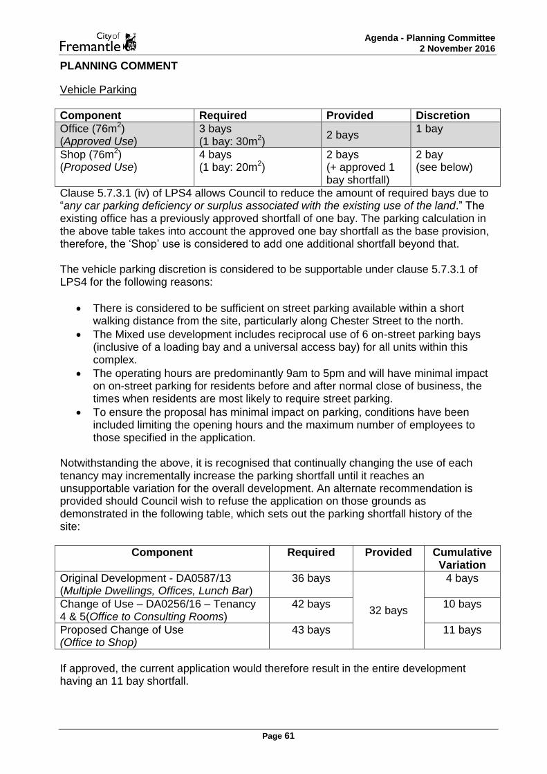
Agenda - Planning Committee 2 November 2016
Page 61
PLANNING COMMENT
Vehicle Parking
Component Required Provided Discretion
Office (76m2) (Approved Use)
3 bays (1 bay: 30m2)
2 bays 1 bay
Shop (76m2) (Proposed Use)
4 bays (1 bay: 20m2)
2 bays (+ approved 1 bay shortfall)
2 bay (see below)
Clause 5.7.3.1 (iv) of LPS4 allows Council to reduce the amount of required bays due to “any car parking deficiency or surplus associated with the existing use of the land.” The existing office has a previously approved shortfall of one bay. The parking calculation in the above table takes into account the approved one bay shortfall as the base provision, therefore, the ‘Shop’ use is considered to add one additional shortfall beyond that. The vehicle parking discretion is considered to be supportable under clause 5.7.3.1 of LPS4 for the following reasons:
There is considered to be sufficient on street parking available within a short walking distance from the site, particularly along Chester Street to the north.
The Mixed use development includes reciprocal use of 6 on-street parking bays (inclusive of a loading bay and a universal access bay) for all units within this complex.
The operating hours are predominantly 9am to 5pm and will have minimal impact on on-street parking for residents before and after normal close of business, the times when residents are most likely to require street parking.
To ensure the proposal has minimal impact on parking, conditions have been included limiting the opening hours and the maximum number of employees to those specified in the application.
Notwithstanding the above, it is recognised that continually changing the use of each tenancy may incrementally increase the parking shortfall until it reaches an unsupportable variation for the overall development. An alternate recommendation is provided should Council wish to refuse the application on those grounds as demonstrated in the following table, which sets out the parking shortfall history of the site:
Component Required Provided Cumulative Variation
Original Development - DA0587/13 (Multiple Dwellings, Offices, Lunch Bar)
36 bays
32 bays
4 bays
Change of Use – DA0256/16 – Tenancy 4 & 5(Office to Consulting Rooms)
42 bays 10 bays
Proposed Change of Use (Office to Shop)
43 bays 11 bays
If approved, the current application would therefore result in the entire development having an 11 bay shortfall.

Agenda - Planning Committee 2 November 2016
Page 62
Land Use A ‘Shop’ is a discretionary land use in a ‘Neighbourhood centre zone’ under the provisions of LPS4. The ‘Shop’ is considered to satisfy the objectives of the zone, as listed in clause 4.2.1(d) of LPS4, for the following reasons:
The use provides for daily and convenience retailing serving the local community.
The limited size of the shop necessarily limits the number of customers on-site at any given time. Thus, the shop is likely to service mostly the local community rather than attract customers from other localities.
As the business predominantly operates during normal business hours and residents utilise on-street parking before and after those hours, the business will not be detrimental to adjoining owners or residential properties in regards to parking.
Conditions limiting the opening hours and number of employees will minimise the detrimental impact on the amenity of the residential area.
An alternate recommendation is provided should Council be of the opinion that the increased parking shortfall (1 bay) will have an unsupportable detrimental impact on the amenity of the residential area. STRATEGIC IMPLICATIONS The proposal is consistent with the City’s following strategic documents: Strategic Community Plan 2015-25
Increase the net lettable area of retail space. ALTERNATE RECOMMENDATION That the application be REFUSED under the Metropolitan Region Scheme and Local Planning Scheme No. 4 for the change of use from Office to Shop at No.3/19 (Lot 3) Douro Road, South Fremantle, as detailed on plans dated 8 September 2016, for the following reason:
1. The proposal would be detrimental to the residential amenity of the area under clause 67(s) – Matters to be considered by local government of the Deemed provisions of the Planning and Development (Local planning Schemes) Regulations 2015 by reasons of the inadequate provision of onsite car parking.

Agenda - Planning Committee 2 November 2016
Page 63
OFFICER'S RECOMMENDATION
That the application be APPROVED under the Metropolitan Region Scheme and Local Planning Scheme No. 4 for the change of use from Office to Shop in an existing Mixed use development at No. 3/19 (Lot 3) Douro Road, South Fremantle, subject to the following condition(s):
1. This approval relates only to the development as indicated on the approved plans, dated 8 September 2016. It does not relate to any other development on this lot and must substantially commence within four years from the date of this decision letter.
2. The Shop hereby permitted shall be limited to the following opening hours:
9am to 5pm Monday to Saturday
5pm to 9pm by appointment on Thursday
No trade Sunday
3. The hereby approved Shop land use is limited to a maximum of two (2) employees (hairdressers, beauticians or otherwise) onsite at any given time.

Agenda - Planning Committee 2 November 2016
Page 64
PC1611-8 HARBOUR ROAD, NO. 11 (LOT 56), SOUTH FREMANTLE - TWO STOREY ANCILLARY DWELLING ADDITION TO EXISTING SINGLE HOUSE- (CJ DA0400/16)
ECM Reference: 059/002 Disclosure of Interest: Nil Meeting Date: 2 November 2016 Responsible Officer: Acting Manager Development Approvals Actioning Officer: Acting Coordinator Statutory Planning Decision Making Level: Planning Committee Previous Item Number/s: Nil Attachments: 1 – Development Plans
2 – Site photographs Date Received: 12 August 2016 Owner Name: William Power Submitted by: As above Scheme: Residential Heritage Listing: Level 3 Existing Landuse: Single House Use Class: Single House Use Permissibility: P

Agenda - Planning Committee 2 November 2016
Page 65
EXECUTIVE SUMMARY
The City has received an application for the addition of a two storey Ancillary dwelling at No. 11 Harbour Road, South Fremantle. The proposal has been assessed against the Residential Design Codes (R-Codes), local planning policies and Local Planning Scheme No. 4 (LPS4), and is seeking the following merit based assessments:
Site works
Visual privacy
Size of Ancillary dwelling The application is referred to Planning Committee for determination, as an objection has been received that cannot be dealt with through the imposition of planning conditions. The proposal is considered to meet Design principles where relevant, and is recommended for conditional planning approval. BACKGROUND
No. 11 Harbour Road, South Fremantle is located in sub area 4.3.3 of the Fremantle South Local Planning Area. The site is located on the southern side of Harbour Road, with the street block being bound by Harbour Road to the north, Chester Street to the east, Douro Road to the south and South Terrace to the west. No. 11 is within the Residential zone and is allocated a density of R30. It is also located within a Heritage Area (South Fremantle) and is on the City’s Heritage List, and MHI as level 3. A single storey Ancillary dwelling was previously approved on the site in May 2016. DETAIL
On 12 August 2016, the City received an application for the addition of a two storey Ancillary Dwelling to rear south eastern corner of the property located at No. 11 Harbour Road, South Fremantle. Revised plans were provided (dated 12 October 2016), that more clearly demonstrated the type and location of openings on the proposed building and noted the use of the mezzanine level as storage on the plans, where a room type was not previously mentioned. It has since been clarified with the applicant that they intend the use of the proposed mezzanine room to be flexible and will regularly be used for storage, but potentially as a living space or bedroom. Revised development plans are included as Attachment 1.

Agenda - Planning Committee 2 November 2016
Page 66
STATUTORY AND POLICY ASSESSMENT
The proposal has been assessed against the relevant provisions of LPS4, the R-Codes and relevant local planning policies. Where a proposal does not meet the Deemed-to-comply requirements of the R-Codes, an assessment is made against the relevant Design principles of the R-Codes. Not meeting the Deemed-to-comply requirements cannot be used as a reason for refusal. In this particular application the areas outlined below do not meet the Deemed-to-comply or policy provisions and need to be assessed under the Design principles:
Site works
Visual privacy
Size of ancillary dwelling The above matters are discussed in detail in the Planning Comment section below. CONSULTATION
Building The applicant is proposing to brace the existing eastern dividing fence as part of this application. The City’s Building Surveyor has advised that a proposal of this nature would require a structural engineer’s certification at the Building stage of the development process. As there is no clear evidence to demonstrate that the bracing will be wholly contained on the subject site (i.e. the dividing fence straddles both boundaries), it is considered appropriate to impose a condition of approval to ensure these supporting structures are to be wholly located within the subject site. Furthermore an appropriate advice note will also be included advising the applicant to seek structural engineer advice if concerns exist in regard to the integrity of this eastern boundary fence. Heritage The City’s Heritage services have reviewed the proposed Ancillary dwelling and no heritage concerns were raised regarding the proposal. Community The application was required to be advertised in accordance with Clause 9.4 of LPS4, as the proposed development is seeking Design principle assessment for a number of elements. At the conclusion of the advertising period, being 2 September 2016, the City had received two (2) submissions from one (1) submitter. The following planning issues were raised (summarised):
Dwelling is not in keeping with streetscape and heritage building
Peace and enjoyment would be impacted as parking would be compromised in street
Privacy is a concern
Height and bulk of building will block off sunlight
Removal of trees will result in impact on ambience of home

Agenda - Planning Committee 2 November 2016
Page 67
Not appropriate to allow imposing and substantial dwelling to be constructed
PLANNING COMMENT
Demolition The application includes the demolition of an Outbuilding (shed) at the rear of the property. In accordance with Clause 5.15.1 of LPS4, the building is supported for demolition as it has limited cultural heritage significance and does not make a significant contribution to the broader cultural heritage significance and character of the locality. Site works
Deemed to comply Provided Design principle assessment
500mm 650mm 150mm
The proposed site works are supported for the following reasons:
The ground level of the eastern adjoining property will still be higher than the proposed new ground level of the Ancillary dwelling.
To the south of the subject site, the portion of fill is partially abutted by a boundary wall.
For the remainder of the southern elevation of this site, the fill abuts a portion of the southern three storey Single house which is setback 8.5m from this common boundary.
The building height for the site complies with the requirements of Schedule 12 of LPS4, being two stories.
The proposed Ancillary dwelling which sits above the site works, is setback from the southern boundary by 3.4m reducing the impact on the southern property by way of shadow.
The setbacks of the proposed Ancillary dwelling are considerate of existing openings on adjoining properties.
The site works are located under the proposed Ancillary dwelling which is at the rear of the site and will not have a significant impact on the streetscape.
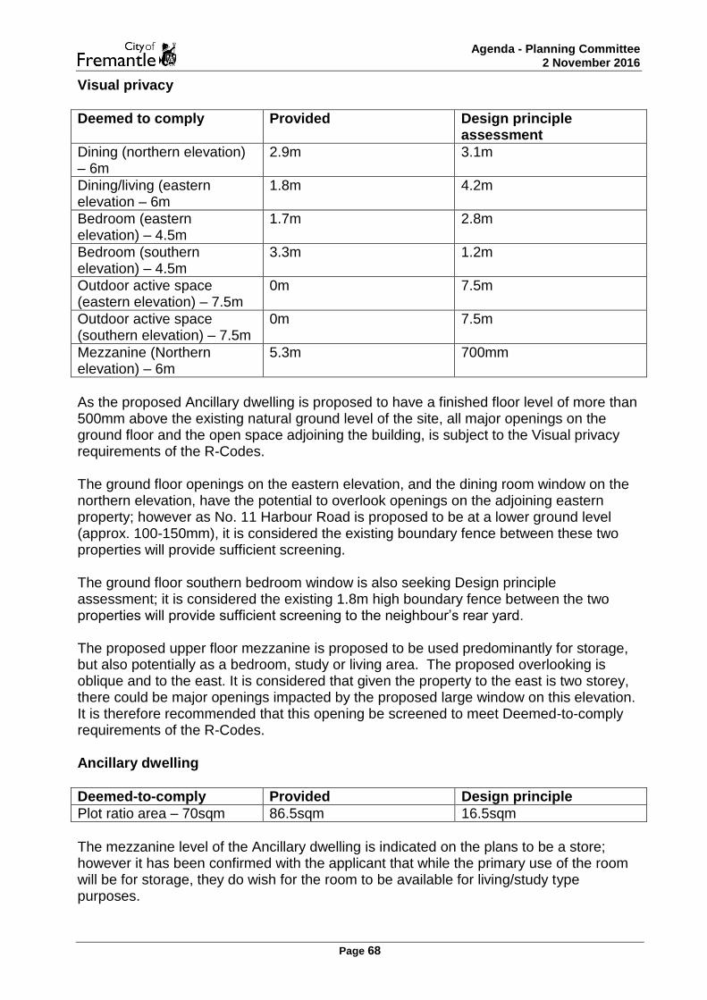
Agenda - Planning Committee 2 November 2016
Page 68
Visual privacy
Deemed to comply Provided Design principle assessment
Dining (northern elevation) – 6m
2.9m 3.1m
Dining/living (eastern elevation – 6m
1.8m 4.2m
Bedroom (eastern elevation) – 4.5m
1.7m 2.8m
Bedroom (southern elevation) – 4.5m
3.3m 1.2m
Outdoor active space (eastern elevation) – 7.5m
0m 7.5m
Outdoor active space (southern elevation) – 7.5m
0m 7.5m
Mezzanine (Northern elevation) – 6m
5.3m 700mm
As the proposed Ancillary dwelling is proposed to have a finished floor level of more than 500mm above the existing natural ground level of the site, all major openings on the ground floor and the open space adjoining the building, is subject to the Visual privacy requirements of the R-Codes. The ground floor openings on the eastern elevation, and the dining room window on the northern elevation, have the potential to overlook openings on the adjoining eastern property; however as No. 11 Harbour Road is proposed to be at a lower ground level (approx. 100-150mm), it is considered the existing boundary fence between these two properties will provide sufficient screening. The ground floor southern bedroom window is also seeking Design principle assessment; it is considered the existing 1.8m high boundary fence between the two properties will provide sufficient screening to the neighbour’s rear yard. The proposed upper floor mezzanine is proposed to be used predominantly for storage, but also potentially as a bedroom, study or living area. The proposed overlooking is oblique and to the east. It is considered that given the property to the east is two storey, there could be major openings impacted by the proposed large window on this elevation. It is therefore recommended that this opening be screened to meet Deemed-to-comply requirements of the R-Codes. Ancillary dwelling
Deemed-to-comply Provided Design principle
Plot ratio area – 70sqm 86.5sqm 16.5sqm
The mezzanine level of the Ancillary dwelling is indicated on the plans to be a store; however it has been confirmed with the applicant that while the primary use of the room will be for storage, they do wish for the room to be available for living/study type purposes.

Agenda - Planning Committee 2 November 2016
Page 69
The plot ratio area of the Ancillary dwelling is supported for the following reasons:
By having the total plot ratio area split over two levels, the ground floor plate of the building is less than the permitted 70sqm plot ratio.
The Ancillary dwelling is to the rear of the existing Single house, allowing an element of interaction.
The Ancillary dwelling has sufficient space and facilities to be able to run independently.
Provides additional, smaller housing on a lot that cannot be subdivided and is designed having regard to the existing heritage home.
STRATEGIC IMPLICATIONS The proposal is consistent with the City’s following strategic documents: Strategic Community Plan 2015-25
Increase the number of people living in Fremantle.
Provide for and seek to increase the number and diversity of residential dwellings in the City of Fremantle.
Green Plan 2020
Encourage the retention of vegetation on private land. It is acknowledged that as part of this proposal the applicant wants to remove a mature tree onsite to accommodate the new footprint for the Ancillary dwelling and that the removal of the tree doesn’t require Council approval. However, the applicant is strongly encouraged to plant a replacement tree onsite in accordance with Council’s Green Plan and as such an appropriate advice note has been included. OFFICER'S RECOMMENDATION
That the application be APPROVED under the Metropolitan Region Scheme and Local Planning Scheme No. 4 for the two storey Ancillary dwelling addition to existing Single House at No. 11 (Lot 56) Harbour Road, South Fremantle, subject to the following condition(s):
1. This approval relates only to the development as indicated on the approved plans, dated 12 October 2016. It does not relate to any other development on this lot and must substantially commence within four years from the date of this decision letter.
2. All storm water discharge shall be contained and disposed of on site or
otherwise approved by the Chief Executive Officer, City of Fremantle.
3. Prior to the issue of a Building Permit, all structures shall be shown to be wholly contained within the property and not fixed to neighbouring properties, to the satisfaction of the Chief Executive Officer, City of Fremantle.

Agenda - Planning Committee 2 November 2016
Page 70
4. Prior to occupation of the development approved as part of DA0400/16, on plans dated 12 October 2016, the mezzanine window located on the north elevation shall be screened in accordance with Clause 5.4.1 C1.1 of the Residential Design Codes by either:
a) fixed obscured or translucent glass to a height of 1.60 metres above
floor level, or b) fixed with vertical screening, with openings not wider than 5cm and
with a maximum of 25% perforated surface area, to a minimum height of 1.60 metres above the floor level, or
c) a minimum sill height of 1.60 metres as determined from the internal floor level, or
d) an alternative method of screening approved by the Chief Executive Officer, City of Fremantle.
The required screening shall be provided and maintained to the satisfaction of the Chief Executive Officer, City of Fremantle.
5. Where any of the preceding conditions has a time limitation for compliance,
if any condition is not met by the time requirement within that condition, then the obligation to comply with the requirements of any such condition (other than the time limitation for compliance specified in that condition), continues whilst the approved development continues.
Advice note:
i. The applicant is advised that if there are concerns regarding the integrity of the existing masonry dividing fence, that advice should be sought from a qualified structural engineer.
ii. The City strongly encourages deep planting zones that should be
uncovered, contain a retained or planted tree to Council’s specification, have a minimum dimension of 3.0m and at least 50% is to be provided on the rear 50% of the site.

Agenda - Planning Committee 2 November 2016
Page 71
PC1611-9 SCHEDULE OF APPLICATIONS DETERMINED UNDER DELEGATED AUTHORITY
Acting under authority delegated by the Council the Manager Development Approvals determined, in some cases subject to conditions, each of the applications listed in the Attachments and relating to the places and proposal listed.
OFFICER'S RECOMMENDATION
That the information is noted.

Agenda - Planning Committee 2 November 2016
Page 72
REPORTS BY OFFICERS (COUNCIL DECISION)
PC1611-10 PROPOSED AMENDMENT NO. 72 TO LOCAL PLANNING SCHEME 4 REZONING OF LAND BOUNDED BY SOUTH STREET, FIFTH AVENUE, LEFROY ROAD AND CAESAR STREET, BEACONSFIELD TO DEVELOPMENT ZONE
ECM Reference: 218/080 Disclosure of Interest: Nil Meeting Date: 2 November 2016 Responsible Officer: Manager Strategic Planning Actioning Officer: Manager Strategic Planning Decision Making Level: Council Previous Item Number/s: Nil Attachments: Scheme amendment report – Amendment No. 72

Agenda - Planning Committee 2 November 2016
Page 73
EXECUTIVE SUMMARY
The City has received a request to initiate an amendment to Local Planning Scheme No. 4, lodged by planning consultants Urbis acting on behalf of the Housing Authority. The proposed scheme amendment relates to land bounded by South Street, Fifth Avenue, Lefroy Road and Caesar Street, Beaconsfield which is predominantly developed with low density housing owned by the Housing Authority. The land in question is currently primarily zoned residential R30 under the local planning scheme, but also includes a local public open space reserve (Davis Park) and a community facilities reserve (Fremantle Early Learning Centre) in the centre of the area. The scheme amendment proposes to rezone the entire area to Development zone. The subject area has been identified by the Housing Authority as a priority precinct within which a greater diversity of housing stock can be achieved through redevelopment and urban renewal. The effect of this rezoning would be to trigger requirements under the Planning and Development (Local Planning Schemes) Regulations 2015 for a local structure plan to be prepared to guide future subdivision and development in the area, thereby providing a coordinated approach to the redevelopment envisaged by the Housing Authority. In a wider context, the land forms part of a broader area being considered through the ‘Beaconsfield West’ Master Planning project which the City is leading in collaboration with representatives of relevant State agencies including the Housing Authority. The project recognises significant relationships between major land parcels in this area and will seek to identify how these relationships could provide opportunities, through a coordinated planning approach, to achieve broader community benefits in association with change in this area. Officers consider the requirement for a structure plan to be prepared as a consequence of rezoning the land would bring benefits as it would increase the likelihood of a more holistic approach to redevelopment of the Housing Authority land being adopted. In view of the length of time the proposed scheme amendment is likely to take to be concluded due to the statutory procedures involved, officers consider commencing the process at this time would not compromise the broader Beaconsfield West master planning process. Accordingly Council is recommended to support commencement of the scheme amendment process. BACKGROUND
Site Context The area bounded by South Street, Fifth Avenue, Lefroy Road and Caesar Street, Beaconsfield is predominantly developed with low density housing owned by the Housing Authority. It also includes a local public open space reserve (Davis Park) and a community facilities reserve (Fremantle Early Learning Centre) in the centre of the area. The area was first developed for housing purposes by the former State Housing Commission (now the Housing Authority) in the late 1940’s, but most of the current housing stock in the area dates from the 1970’s. There are currently approximately 220 dwellings in the area, mostly grouped dwelling/unit style development ranging between 1 and 4 bedrooms in size but nearly 50% of the total housing stock comprises 3 or 4

Agenda - Planning Committee 2 November 2016
Page 74
bedroomed dwellings. Except for three strata titled lots in private ownership, all residential lots in the area are owned by the Housing Authority (the HA). Access into the area from the perimeter streets is via a series of culs-de-sac which terminate each side of the Davis Park public open space. There are a number of mature trees spread throughout the area, and Davis Park itself (managed by the City of Fremantle) was upgraded in 2015 to include new recreational facilities such as a nature play area and basketball court. The Early Learning Centre adjacent to Davis Park is a community-based not for profit centre catering for 0 to 5 year-olds. To the east and north of the subject land are established residential areas and a small local commercial centre around the intersection of South Street and Fifth Avenue. To the west is the Bruce Lee Reserve with sports playing fields and one campus of the South Metropolitan TAFE, and to the south on the opposite side of Lefroy Road is the South Fremantle High School (SFHS). The Department of Education has recently announced the development of a new public high school on the SFHS site to replace the current SFHS and Hamilton Senior High School which will both close. The new school is scheduled to open at the start of Semester 1, 2018. Project Context The subject area has been identified by the HA as a priority precinct within which a greater diversity of housing stock can be achieved through redevelopment and urban renewal. Whilst the HA anticipates that a proportion of social housing stock would remain in the area, it is not anticipated that this would be more than 11% of total dwellings in the redeveloped precinct. This would align with recent developments the HA has undertaken across the state. The HA considers that redevelopment in this location could capitalise on the area’s proximity to South Street, which is a strategically important public transport corridor, and the local centre adjoining the north-east corner of the area. Redevelopment of the area, including opportunities for increased residential densities close to South Street, would be consistent with the Western Australian Planning Commission’s draft Central Sub-Regional Framework and other key state government strategic planning documents. In a wider context, the land forms part of a broader area being considered through the ‘Beaconsfield West’ Master Planning project which the City is leading in collaboration with representatives of relevant State agencies including the HA. Council has allocated $40,000 to this project in the 2016/17 budget. The project recognises significant spatial relationships between major land parcels in this area including the HA land, Bruce Lee Reserve, the TAFE site, the SFHS site and the Lefroy Road Quarry structure plan area. It will seek to identify how these relationships could provide opportunities, through a coordinated planning approach, to achieve broader community benefits in association with change in this area (such as development of the new high school and future use of the TAFE site following the planned relocation of the TAFE facilities to other campuses over the next few years).

Agenda - Planning Committee 2 November 2016
Page 75
DETAILS OF PROPOSAL The proposal, submitted by planning consultants Urbis on behalf of the HA on 18 October 2016, is for an amendment to the City of Fremantle Local Planning Scheme No. 4 (LPS4) to rezone all of the land bounded by South Street, Fifth Avenue, Lefroy Road and Caesar Street as described in the Background section above from Residential R30, Local Scheme Open Space Reserve and Local Scheme Community Facilities Reserve to Development zone. This requires an amendment to the LPS4 Scheme Map as shown below:

Agenda - Planning Committee 2 November 2016
Page 76
The effect of this rezoning would be to trigger requirements under Part 4 of the Planning and Development (Local Planning Schemes) Regulations 2015 (the P&D Regulations) for a local structure plan to be prepared to guide future subdivision and development in the area, thereby providing a coordinated approach to the redevelopment envisaged by the HA. The structure plan would need to be approved by the Western Australian Planning Commission (WAPC) based on a recommendation by the City prior to any applications for subdivision or development approval for new forms of development in the area being submitted. The applicants have requested the City to support initiation of the proposed scheme amendment at this time because of the length of time it is likely to take for the amendment to progress to the point of final determination by the Minister for Planning (probably in the order of 12-18 months). This means that the broader Beaconsfield West master planning process can proceed concurrently with the scheme amendment process, and outcomes from the master planning process can be finalised before, or at the same time as, completion of the scheme amendment. The master plan can then inform the preparation of a structure plan for the HA land following its rezoning to Development zone (assuming this is supported by the City, the WAPC and the Minister for Planning). A copy of the submitted scheme amendment report prepared by the applicants is provided in Attachment 1. STATUTORY AND POLICY ASSESSMENT
Under the P&D Regulations, amendments to local planning schemes are classified into one of three types – basic, standard or complex. This proposed scheme amendment is considered to be a complex amendment on the basis that regulation 34 of the P&D Regulations defines a complex amendment as including: (c) an amendment relating to development that is of a scale, or will have an impact, that is significant relative to development in the locality. The currently proposed amendment applies to an area of approximately 10 hectares and seeks to rezone all of this land to Development zone in order to facilitate comprehensive redevelopment through a structure planning process. Although the exact form of new development is unspecified at this stage, it could include development that is significantly different to that which currently exists in the locality. On this basis the applicant’s planning consultants and the City’s planning officers consider the amendment falls within the above definition of a complex amendment. The statutory process applying to a complex amendment under the P&D Regulations includes obtaining the WAPC’s advice on whether any modification to the documentation is required before the amendment is advertised for public comment, and a longer advertising period than a standard amendment (a minimum of 60 days rather than 42 days). The subject land is zoned Urban under the Metropolitan Region Scheme (MRS), with the exception of a 10 metre deep portion of the lots along the northern edge of the area which have direct frontage to South Street. This land comprises part of the South Street Primary Regional Road Reserve under the MRS and has been excluded from the

Agenda - Planning Committee 2 November 2016
Page 77
proposed local scheme amendment. The proposed rezoning of the remainder of the area to Development zone under LPS4 would be consistent with the Urban zoning under the MRS. The State Government’s strategic planning documents Directions 2031 and beyond and more recent draft Perth and Peel at 3.5 million and Central Sub-regional Planning Framework set objectives of achieving a higher proportion of metropolitan Perth’s future housing growth in infill locations, providing greater diversity of housing types in established inner suburbs to improve affordability in these areas, and investigating identified corridors served by existing or planned high quality public transport as the focus for increased densities and a mix of suitable land uses. South Street is identified as one such corridor in the draft Central Sub-regional Planning Framework. The City’s Strategic Community Plan 2015-25 identifies ‘Places for People’ as one of its strategic focus areas. Objectives under this focus area include increasing affordable, adaptive, accessible and diverse housing; improved density in urban centres and transit corridors, and improved urban/suburban amenity with green spaces. The City has already undertaken an amendment to LPS4 (amendment no. 65) to facilitate development at higher (up to R100) residential density and building heights on the Local Centre zoned lots fronting South Street immediately north-east of the HA owned residential area. Council’s rationale for supporting this amendment was that this location was an appropriate nodal point along a major public transport corridor at which to support higher density development which could help sustain investment in improved building stock and services to the local community. This scheme amendment has recently been considered by the WAPC and is currently awaiting final determination by the Minister for Planning. CONSULTATION
Subject to Council resolving to proceed to advertise the proposed scheme amendment, it will be advertised in accordance with the requirements of the P&D Regulations as they apply to complex scheme amendments. These include a period within which submissions may be made of not less than 60 days. Additional forms of community engagement specified for this type of scheme amendment in the City’s Local Planning Policy 1.3 Public Notification of Planning Proposals, including a community information session, notification to the local precinct groups and individual notification to property owners and occupiers within and surrounding the scheme amendment area, would also be carried out. Due to the requirement to refer the scheme amendment to the WAPC for preliminary examination prior to advertising, community engagement on the proposal is not likely to occur until February/March 2017 at the soonest. PLANNING COMMENT
The purpose of the proposed rezoning is to enable the preparation of a local structure plan to guide future comprehensive redevelopment of the subject land. The existing housing stock in the area dates predominantly from the 1970’s and has limited diversity in terms of tenure and building typologies. The State and the City’s strategic policy documents recognise locations along key transport corridors such as South Street as

Agenda - Planning Committee 2 November 2016
Page 78
being appropriate for additional and more diverse residential development, including some development at higher densities where the development has good access to open space and local services. Consequently officers consider that so long as the preparation of a structure plan for the HA land occurs in a manner and on a timeframe that is properly integrated with the outcomes of the broader Beaconsfield West master planning process, including community engagement stages of the broader process which are currently anticipated to occur in early 2017, then the current scheme amendment could be supported. The proposed rezoning to development zone is simply an enabling step to trigger a statutory requirement to prepare a structure plan. The rezoning in itself does not propose specific development outcomes, but it will ensure that matters such as supporting infrastructure requirements, transport and traffic implications, and community and other stakeholder interests are given proper consideration before the process of preparing a structure plan begins and can therefore inform the structure plan design. In view of the length of time the proposed scheme amendment is likely to take to be concluded due to the statutory procedures involved, officers consider commencing the process at this time would not compromise the broader Beaconsfield West master planning process. As nearly all of the land subject to the proposed rezoning is owned by the HA, difficulties that have been encountered by the City in other locations where Development zones cover land in multiple separate ownerships and separate, uncoordinated structure plans have been submitted by different owners for different parts of the zone are considered unlikely to occur in this instance. CONCLUSION Amending LPS4 to rezone the subject land to development zone would be a preliminary step to facilitate preparation of a structure plan to guide future redevelopment of the large area of Housing Authority-owned housing stock in this area. Given the amount of land intended for future redevelopment in this case, officers consider the requirement for a structure plan to be prepared as a consequence of rezoning the land would bring benefits as it would increase the likelihood of a more holistic approach to redevelopment being adopted. Subject to the proposed scheme amendment not prejudicing the broader Beaconsfield West master planning process which covers a larger area, including the land subject to the amendment, officers consider the amendment could be supported to proceed to advertising. The Beaconsfield West project has recently commenced and is anticipated to include a community engagement component in early 2017. It is unlikely that the statutory public consultation process on the proposed scheme amendment will be able to commence before that date, and therefore officers consider there is minimal risk of the timing of the scheme amendment compromising the scope and intended outcomes of the broader master planning project. On that basis, it is recommended that Council resolve to adopt the proposed amendment as a complex amendment to Local Planning Scheme No.4.

Agenda - Planning Committee 2 November 2016
Page 79
OFFICER'S RECOMMENDATION That Council resolves:
1. Pursuant to regulation 35(1) of the Planning and Development (Local Planning Schemes) Regulations 2015, to adopt the following amendment to City of Fremantle Local Planning Scheme No. 4:
(a) Rezone and reclassify the land bounded by South Street to the north,
Lefroy Road to the south, Fifth Avenue to the east and Caesar Street to the west from a Residential ‘R30’ zone, Open Space Local Scheme Reserve and Community Facility – Community Facilities Local Scheme Reserve to a Development zone.
(b) Modifying the Scheme Map accordingly.
2. In its opinion, the Amendment is a complex amendment for the following
reason: it is an amendment relating to development that is of a scale, or will have an impact, that is significant relative to development in the locality.
3. That the Mayor and Chief Executive Officer be authorised to execute the
relevant scheme amendment documentation.
4. That the amendment be submitted to the Environmental Protection Authority for determination of whether an environmental review is required.
5. That subject to the Environmental Protection Authority determining that an
environmental review is not required, pursuant to regulation 37 of the Planning and Development (Local Planning Schemes) Regulations 2015 the scheme amendment be referred to the Western Australian Planning Commission and the Commission be informed that the City of Fremantle has resolved to proceed to advertise the amendment without modification.

Agenda - Planning Committee 2 November 2016
Page 80
CONFIDENTIAL MATTERS
Nil.

Agenda - Planning Committee 2 November 2016
Page 81
SUMMARY GUIDE TO CITIZEN PARTICIPATION & CONSULTATION
The Council adopted a Community Engagement Policy in December 2010 to give effect to its commitment to involving citizens in its decision-making processes. The City values community engagement and recognises the benefits that can flow to the quality of decision-making and the level of community satisfaction. Effective community engagement requires total clarity so that Elected Members, Council officers and citizens fully understand their respective rights and responsibilities as well as the limits of their involvement in relation to any decision to be made by the City.
How consultative processes work at the City of Fremantle
The City’s decision makers 1. The Council, comprised of Elected Members, makes policy, budgetary and key strategic decisions while the CEO, sometimes via on-delegation to other City officers, makes operational decisions.
Various participation opportunities 2. The City provides opportunities for participation in the decision-making process by citizens via itscouncil appointed working groups, its community precinct system, and targeted community engagement processes in relation to specific issues or decisions.
Objective processes also used 3. The City also seeks to understand the needs and views of the community via scientific and objective processes such as its bi-ennial community survey.
All decisions are made by Council or the CEO
4. These opportunities afforded to citizens to participate in the decision-making process do not include the capacity to make the decision. Decisions are ultimately always made by Council or the CEO (or his/her delegated nominee).
Precinct focus is primarily local, but also city-wide
5. The community precinct system establishes units of geographic community of interest, but provides for input in relation to individual geographic areas as well as on city-wide issues.
All input is of equal value 6. No source of advice or input is more valuable or given more weight by the decision-makers than any other. The relevance and rationality of the advice counts in influencing the views of decision-makers.
Decisions will not necessarily reflect the majority view received
7. Local Government in WA is a representative democracy. Elected Members and the CEO are charged under the Local Government Act with the responsibility to make decisions based on fact and the merits of the issue without fear or favour and are accountable for their actions and decisions under law. Elected Members are accountable to the people via periodic elections. As it is a representative democracy, decisions may not be made in favour of the majority view expressed via consultative processes. Decisions must also be made in accordance with any statute that applies or within the parameters of budgetary considerations. All consultations will clearly outline from the outset any constraints or

Agenda - Planning Committee 2 November 2016
Page 82
How consultative processes work at the City of Fremantle
limitations associated with the issue.
Decisions made for the overall good of Fremantle
8. The Local Government Act requires decision-makers to make decisions in the interests of “the good government of the district”. This means that decision-makers must exercise their judgment about the best interests of Fremantle as a whole as well as about the interests of the immediately affected neighbourhood. This responsibility from time to time puts decision-makers at odds with the expressed views of citizens from the local neighbourhood who may understandably take a narrower view of considerations at hand.
Diversity of view on most issues 9. The City is wary of claiming to speak for the ‘community’ and wary of those who claim to do so. The City recognises how difficult it is to understand what such a diverse community with such a variety of stakeholders thinks about an issue. The City recognises that, on most significant issues, diverse views exist that need to be respected and taken into account by the decision-makers.
City officers must be impartial 10. City officers are charged with the responsibility of being objective, non-political and unbiased. It is the responsibility of the management of the City to ensure that this is the case. It is also recognised that City officers can find themselves unfairly accused of bias or incompetence by protagonists on certain issues and in these cases it is the responsibility of the City’s management to defend those City officers.
City officers must follow policy and procedures
11. The City’s community engagement policy identifies nine principles that apply to all community engagement processes, including a commitment to be clear, transparent, responsive , inclusive, accountable andtimely. City officers are responsible for ensuring that the policy and any other relevant procedure is fully complied with so that citizens are not deprived of their rights to be heard.

Agenda - Planning Committee 2 November 2016
Page 83
How consultative processes work at the City of Fremantle
Community engagement processes have cut-off dates that will be adhered to.
12. As City officers have the responsibility to provide objective, professional advice to decision-makers, they are entitled to an appropriate period of time and resource base to undertake the analysis required and to prepare reports. As a consequence, community engagement processes need to have defined and rigorously observed cut-off dates, after which date officers will not include ‘late’ input in their analysis. In such circumstances, the existence of ‘late’ input will be made known to decision-makers. In most cases where community input is involved, the Council is the decision-maker and this affords community members the opportunity to make input after the cut-off date via personal representations to individual Elected Members and via presentations to Committee and Council Meetings.
Citizens need to check for any changes to decision making arrangements made
13. The City will take initial responsibility for making citizens aware of expected time-frames and decision making processes, including dates of Standing Committee and Council Meetings if relevant. However, as these details can change, it is the citizens responsibility to check for any changes by visiting the City’s website, checking the Fremantle News in the Fremantle Gazette or inquiring at the Customer Service Centre by phone, email or in-person.
Citizens are entitled to know how their input has been assessed
14. In reporting to decision-makers, City officers will in all cases produce a community engagement outcomes report that summarises comment and recommends whether it should be taken on board, with reasons.
Reasons for decisions must be transparent
15. Decision-makers must provide the reasons for their decisions.
Decisions posted on the City’s website 16. Decisions of the City need to be transparent and easily accessed. For reasons of cost, citizens making input on an issue will not be individually notified of the outcome, but can access the decision at the City’s website under ‘community engagement’ or at the City Library or Service and Information Centre.
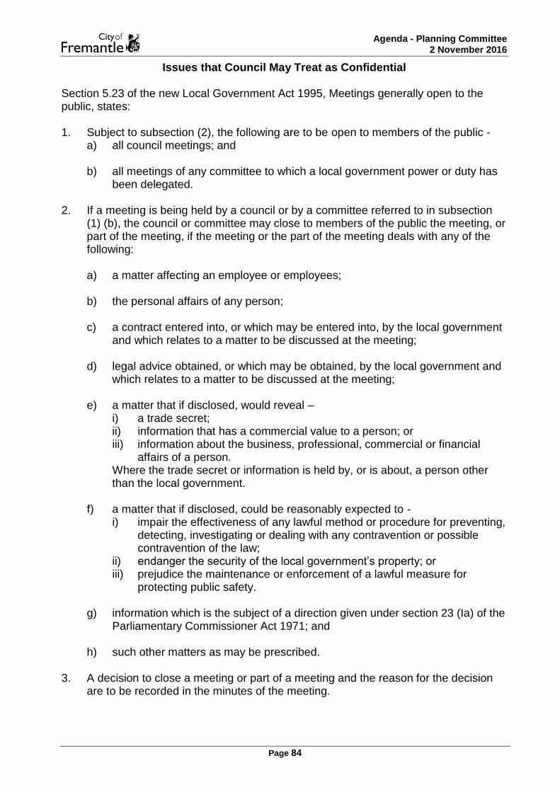
Agenda - Planning Committee 2 November 2016
Page 84
Issues that Council May Treat as Confidential Section 5.23 of the new Local Government Act 1995, Meetings generally open to the public, states: 1. Subject to subsection (2), the following are to be open to members of the public -
a) all council meetings; and b) all meetings of any committee to which a local government power or duty has
been delegated.
2. If a meeting is being held by a council or by a committee referred to in subsection (1) (b), the council or committee may close to members of the public the meeting, or part of the meeting, if the meeting or the part of the meeting deals with any of the following:
a) a matter affecting an employee or employees; b) the personal affairs of any person; c) a contract entered into, or which may be entered into, by the local government
and which relates to a matter to be discussed at the meeting; d) legal advice obtained, or which may be obtained, by the local government and
which relates to a matter to be discussed at the meeting; e) a matter that if disclosed, would reveal –
i) a trade secret; ii) information that has a commercial value to a person; or iii) information about the business, professional, commercial or financial
affairs of a person. Where the trade secret or information is held by, or is about, a person other than the local government.
f) a matter that if disclosed, could be reasonably expected to - i) impair the effectiveness of any lawful method or procedure for preventing,
detecting, investigating or dealing with any contravention or possible contravention of the law;
ii) endanger the security of the local government’s property; or iii) prejudice the maintenance or enforcement of a lawful measure for
protecting public safety.
g) information which is the subject of a direction given under section 23 (Ia) of the Parliamentary Commissioner Act 1971; and
h) such other matters as may be prescribed.
3. A decision to close a meeting or part of a meeting and the reason for the decision are to be recorded in the minutes of the meeting.

Agenda - Planning Committee 2 November 2016
Page 85