
AGENDA , 2020 2:00 P.M. 101 E. Wilson Street, 2
19
AGENDA August 4 th , 2020 2:00 P.M. Board of Commissioners of Public Lands 101 E. Wilson Street, 2 nd Floor Madison, Wisconsin Routine Business: 1. Call to Order 2. Approve Minutes – July 21 st , 2020 (Attachment) 3. Approve Loans (Attachment) Old Business: 4. City of Sturgeon Bay Submerged Land Lease 5. Revisit and discuss goals and priorities of BCPL New Business: None Routine Business: 6. Chief Investment Officer’s Report 7. Executive Secretary’s Report 8. Board Chair’s Report 9. Future Agenda Items 10. Adjourn AUDIO ACCESS INFORMATION ------------------------ Toll Free Number: (888) 291-0079 Passcode: 6363690# Board of Commissioners of Public Lands 08/04/2020 Page 1 of 19
Transcript of AGENDA , 2020 2:00 P.M. 101 E. Wilson Street, 2

AGENDA August 4th, 2020
2:00 P.M. Board of Commissioners of Public Lands
101 E. Wilson Street, 2nd Floor Madison, Wisconsin
Routine Business:
1. Call to Order
2. Approve Minutes – July 21st, 2020 (Attachment)
3. Approve Loans (Attachment)
Old Business:
4. City of Sturgeon Bay Submerged Land Lease
5. Revisit and discuss goals and priorities of BCPL
New Business: None
Routine Business:
6. Chief Investment Officer’s Report
7. Executive Secretary’s Report
8. Board Chair’s Report
9. Future Agenda Items
10. Adjourn
AUDIO ACCESS INFORMATION ------------------------
Toll Free Number: (888) 291-0079 Passcode: 6363690#
Board of Commissioners of Public Lands 08/04/2020 Page 1 of 19
State of Wisconsin Board of Commissioners of Public Lands
Board Meeting Minutes July 21st, 2020
Present were:
Sarah Godlewski, Board Chair State Treasurer Josh Kaul, Commissioner Attorney General Doug LaFollette, Commissioner Secretary of State
Tom German, Executive Secretary Board of Commissioners of Public Lands Richard Sneider, Chief Investment Officer Board of Commissioners of Public Lands Mike Krueger, IT Manager Board of Commissioners of Public Lands Denise Nechvatal, Senior Accountant Board of Commissioners of Public Lands Thuy Nguyen, Office Manager Board of Commissioners of Public Lands Julie Benkoske State Treasurer’s Office
ITEM 1. CALL TO ORDER
Board Chair Godlewski called the meeting to order at 2:02 p.m.
ITEM 2. APPROVE MINUTES – July 7, 2020.
MOTION: Commissioner LaFollette moved to approve the minutes; Commissioner Kaul seconded the motion.
DISCUSSION: None.
VOTE: The motion passed 3-0.
ITEM 3. APPROVE LOANS
MOTION: Commissioner Kaul moved to approve the loans; Board Chair Godlewski seconded the motion.
DISCUSSION: Mr. Sneider commented that the loans were all pretty standard this week. He added that there will be a significantly higher number of loans for approval at the next meeting.
VOTE: The motion passed 3-0.
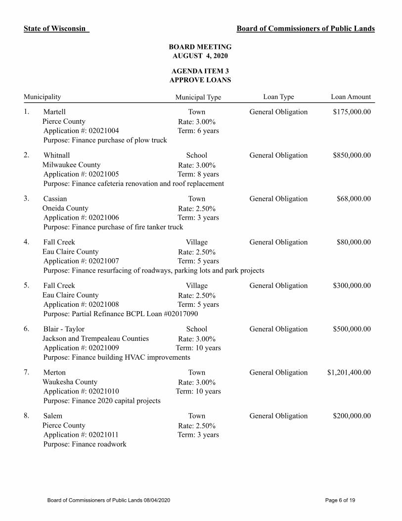
The Board of Commissioners of Public Lands (BCPL) unanimously approved $1,070,000.00 in State Trust Fund Loans to support 3 community projects in Wisconsin.
1. Town of Presque Isle / Vilas County / Finance roadwork / $500,000.002. Village of Nashotah / Waukesha County / Finance roadwork / $270,000.003. Village of Summit / Waukesha County / Finance 2020 Capital Improvement Program / $300,000.00
Board of Commissioners of Public Lands 08/04/2020 Page 2 of 19
ITEM 4. OLD BUSINESS – NONE
ITEM 5. NEW BUSINESS - NONE
ITEM 6. CHIEF INVESTMENT OFFICER'S REPORT
Mr. Sneider shared that BCPL continues to purchase preferred stock ETFs, which have a greater yield and lower risk profile than common stocks at this time. Within the next four weeks BCPL will be at its $50 million allocation set by the investment committee. The next investments being considered by the investment committee will be infrastructure funds that also provide higher yields and lower volitivity than many other asset classes moving to the goal of providing higher distribution and greater stability than before the implementation of the investment policy.
ITEM 7. EXECUTIVE SECRETARY’S REPORT
Executive Secretary German shared that BCPL will be presenting a proposed submerged lands lease for consideration at the next board meeting. The City of Sturgeon Bay is looking to lease part of its downtown area. The area has been filled lakebed for many years. The purpose of the lease will be primarily recreation related to navigation.
Executive Secretary German commented that last week he spoke too soon. At the last board meeting he had shared that Senior forester, Kevin Burns, was back full time with BCPL but he has been called back to work again for DHS on the COVID mapping effort. Kevin will be spending a significant time with DHS again.
Executive Secretary German also shared that he has been asked to attend, virtually, the Voigt Intertribal Task Force of the Great Lakes Indian Fish & Wildlife Commission (GLIFWC) meeting in early August. Some of the members expressed interest in learning more about BCPL as a result of discussions about our proposed land exchange with the USFS. At the last meeting, he reported that GLIFWC officials expressed cautious support for the transaction and also expressed interest in the possibility that BCPL might consider entering into a memorandum of understanding (MOU) with local tribes similar to the MOU that BCPL has with the Forest County Potawatomi Community.
Commissioner LaFollette asked about Sturgeon Bay and whether the submerged land lease pertained to the same issue that was discussed many years ago.
Executive Secretary German responded that it does pertain to the same issue from years ago.
Commissioner LaFollette commented that he recalled when Executive Secretary German went to Sturgeon Bay and looked at the area and saw all the problems with it.
Executive Secretary German shared that a century ago there were docks that extended from the land in that area of Sturgeon Bay out into the water. Over time they were filled in along with the area around it. The entire area in that part of downtown has been neglected over the years. The community has come together to resolve this and work to make it an accessible part of downtown so people can have access to the water.
Commissioner LaFollette commented that he remembers that there were some laws broken or something along those lines.
Board of Commissioners of Public Lands 08/04/2020 Page 3 of 19

Executive Secretary German explained that there were some developers that were looking at putting developments on that land which led to some environmental organizations suing the city. The organizations claimed that the land in question was filled lakebed and that those developments could not be done.
Commissioner LaFollette recalled that a group had contacted him, and he spoke with some people in Sturgeon Bay about the situation.
Executive Secretary German commented that BCPL has consistently maintained that the area is filled lakebed and it should be leased and it can only be leased for certain purposes.
Commissioner LaFollette asked if they are to lease it from BCPL and for what purposes will they be leasing it.
Executive Secretary German replied that the main purpose is recreation related to navigation. The city is trying to make the area more accessible to the people. Right now, it is mostly crumpled parking lot. The city is looking at putting some improvements down in that area so that people can sit and enjoy the water and get to the water.
Commissioner LaFollette asked if there a plan to put in a marina or something similar.
Executive Secretary German responded that there are no plans for a marina or hotel or anything like that right now. The City has docked tugboats on the shore there and they may continue to do that because navigation is one of the additional purposes of the lease.
Commissioner LaFollette asked if the new area will mostly be a city park.
Executive Secretary German replied that that is a good way to describe it, although he is uncertain how much green space there will be, it may be more an urban park but generally that is the description provided right now.
Commissioner LaFollette thanked Executive Secretary German for the discussion.
Executive Secretary German shared that he felt good that BCPL is a part of resolving this issue.
ITEM 8. BOARD CHAIR’S REPORT
Board Chair Godlewski shared that she wanted to check in with the other commissioners about the agency’s achievements and future. She added that she would like to revisit the goals and priorities that were discussed last fall and asked if that would be of interest to the other commissioners.
Commissioner Kaul commented that he thought that was a good idea.
Commissioner LaFollette asked for clarification about the items Board Chair Godlewski wanted to discuss.
Board Chair Godlewski commented that she has the advantage of participating with the agency more because of the investment committee meetings and wanted to have more communication with the commissioners and hoped to meet to discuss the goals and priorities in August sometime.
Commissioner LaFollette replied that that sounds good.
Board of Commissioners of Public Lands 08/04/2020 Page 4 of 19

Thomas P. German, Executive Secretary
ITEM 9. FUTURE AGENDA ITEMS
1. Sturgeon Bay submerged land lease2. Revisit and discuss Board goals and priorities
ITEM 10. ADJOURN
Commissioner LaFollette moved to adjourn the meeting; Commissioner Kaul seconded the
motion. The motion passed 3-0; the meeting adjourned at 2:14 p.m.
Link to audio recording: https://bcpl.wisconsin.gov/Shared Documents/Board Meeting Docs/2020/2020-07-21_BoardMtgRecording.mp3
Board of Commissioners of Public Lands 08/04/2020 Page 5 of 19
State of Wisconsin
BOARD MEETINGAUGUST 4, 2020
AGENDA ITEM 3 APPROVE LOANS
Board of Commissioners of Public Lands
Municipality Municipal Type Loan AmountLoan Type
Town $175,000.00Martell1. General Obligation
Rate: 3.00%Pierce CountyTerm: 6 yearsApplication #: 02021004
Purpose: Finance purchase of plow truck
School $850,000.00Whitnall2. General Obligation
Rate: 3.00%Milwaukee CountyTerm: 8 yearsApplication #: 02021005
Purpose: Finance cafeteria renovation and roof replacement
Town $68,000.00Cassian3. General Obligation
Rate: 2.50%Oneida CountyTerm: 3 yearsApplication #: 02021006
Purpose: Finance purchase of fire tanker truck
Village $80,000.00Fall Creek4. General Obligation
Rate: 2.50%Eau Claire CountyTerm: 5 yearsApplication #: 02021007
Purpose: Finance resurfacing of roadways, parking lots and park projects
Village $300,000.00Fall Creek5. General Obligation
Rate: 2.50%Eau Claire CountyTerm: 5 yearsApplication #: 02021008
Purpose: Partial Refinance BCPL Loan #02017090
School $500,000.00Blair - Taylor6. General Obligation
Rate: 3.00%Jackson and Trempealeau CountiesTerm: 10 yearsApplication #: 02021009
Purpose: Finance building HVAC improvements
Town $1,201,400.00Merton7. General Obligation
Rate: 3.00%Waukesha CountyTerm: 10 yearsApplication #: 02021010
Purpose: Finance 2020 capital projects
Town $200,000.00Salem8. General Obligation
Rate: 2.50%Pierce CountyTerm: 3 yearsApplication #: 02021011
Purpose: Finance roadwork
Board of Commissioners of Public Lands 08/04/2020 Page 6 of 19
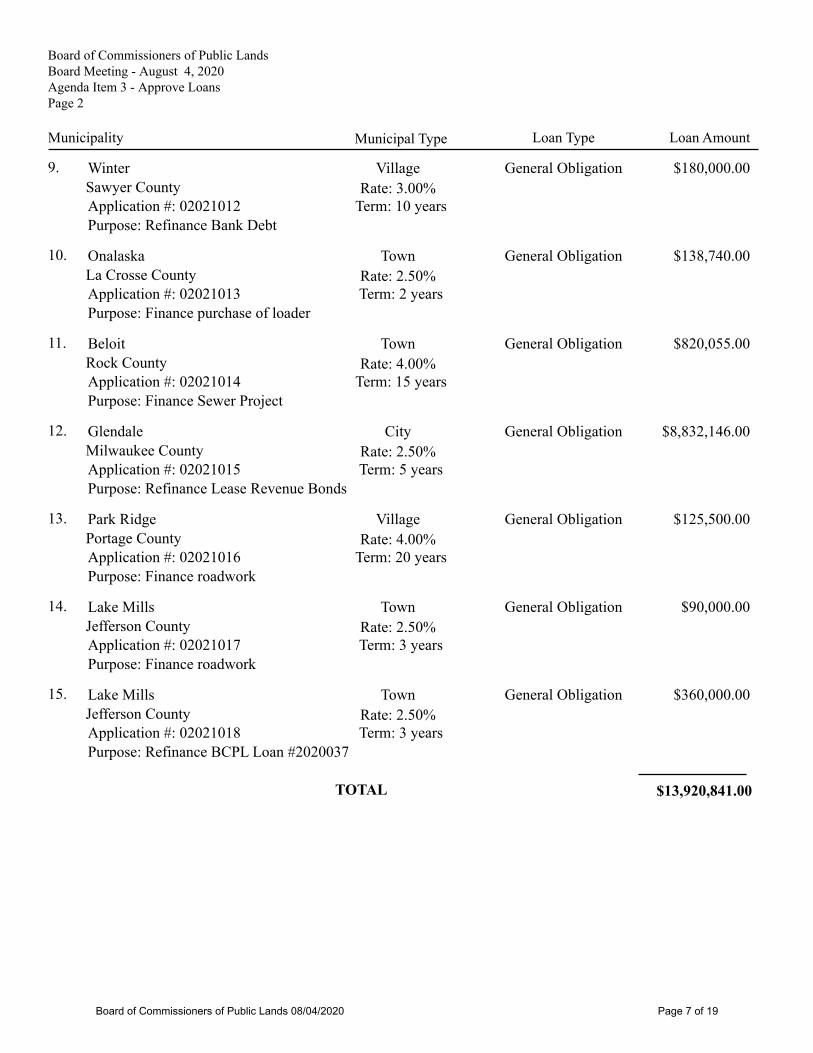
Board of Commissioners of Public LandsBoard Meeting - August 4, 2020Agenda Item 3 - Approve LoansPage 2
Municipality Municipal Type Loan AmountLoan Type
Village $180,000.00Winter9. General Obligation
Rate: 3.00%Sawyer CountyTerm: 10 yearsApplication #: 02021012
Purpose: Refinance Bank Debt
Town $138,740.00Onalaska10. General Obligation
Rate: 2.50%La Crosse CountyTerm: 2 yearsApplication #: 02021013
Purpose: Finance purchase of loader
Town $820,055.00Beloit11. General Obligation
Rate: 4.00%Rock CountyTerm: 15 yearsApplication #: 02021014
Purpose: Finance Sewer Project
City $8,832,146.00Glendale12. General Obligation
Rate: 2.50%Milwaukee CountyTerm: 5 yearsApplication #: 02021015
Purpose: Refinance Lease Revenue Bonds
Village $125,500.00Park Ridge13. General Obligation
Rate: 4.00%Portage CountyTerm: 20 yearsApplication #: 02021016
Purpose: Finance roadwork
Town $90,000.00Lake Mills14. General Obligation
Rate: 2.50%Jefferson CountyTerm: 3 yearsApplication #: 02021017
Purpose: Finance roadwork
Town $360,000.00Lake Mills15. General Obligation
Rate: 2.50%Jefferson CountyTerm: 3 yearsApplication #: 02021018
Purpose: Refinance BCPL Loan #2020037
$13,920,841.00TOTAL
Board of Commissioners of Public Lands 08/04/2020 Page 7 of 19
State of Wisconsin Board of Commissioners of Public Lands
BOARD MEETING AUGUST 4, 2020
AGENDA ITEM 5 PROPOSED SUBMERGED LANDS LEASE – CITY OF STURGEON BAY
A. The City of Sturgeon Bay (“Sturgeon Bay”) desires to place improvements on the filled bed of Lake Michigan in their downtown waterfront area.
B. Pursuant to the Wisconsin constitution, the state holds the beds of lakes in trust for the citizens of Wisconsin. In order to legally place such improvements on the filled lakebed, Sturgeon Bay must obtain the regulatory approval of the Wisconsin DNR and furthermore, Sturgeon Bay must also execute a Submerged Lands Lease with the Board of Commissioners of Public Lands which acts as leasing agent for the State of Wisconsin pursuant to Wis. Stats. Section 24.39(4).
C. The area that would be subject to the lease is a parcel of land in Door County Wisconsin, City of Sturgeon Bay, described on Attached Exhibit A (the “Proposed Lease Premises”). Map of the Proposed Lease Premises is attached as Exhibit B. Sturgeon Bay is the riparian owner of the upland adjacent to the Proposed Lease Premises.
D. The Wisconsin Department of Natural Resources has issued Findings pursuant to Wisconsin Statutes 30.11 (the “Findings”) concluding that the proposed physical changes will be consistent with the public interest in the navigable waters of Lake Michigan provided certain conditions are met. A copy of the Findings is attached as Exhibit C.
E. The proposed improvements for the Proposed Lease Premises are intended to provide the public with generally free, enhanced access to the harbor and enjoyment of the waters of Lake Michigan. As the proposed purpose of the lease is for the benefit of the public and, the public will have access to the Proposed Lease Premises, Sturgeon Bay respectfully requests that the annual base rent for the proposed submerged land lease be set at a nominal amount. BCPL staff believes that $200 per year is a reasonable amount of base rent as the lease does not inure to the benefit of private parties.
F. For the above reasons, BCPL staff recommends that the Board authorize a Submerged Lands Lease for the Proposed Lease Area with the city of Sturgeon Bay:
• For the purpose of recreation related to navigation and navigation improvements;• at a base rental rate of $200 per year;• for a term of no more than 50 years;• subject to the conditions set forth in the DNR’s published Findings;• and on such other terms and conditions as the BCPL Executive Secretary
determines to be reasonable and necessary.
Board of Commissioners of Public Lands 08/04/2020 Page 8 of 19

PROPOSED RESOLUTION
NOW, THEREFORE BE IT RESOLVED, that the Board of Commissioners of Public Lands authorizes a Submerged Lands Lease for a term of up to fifty years for the Proposed Lease Area with the city of Sturgeon Bay in accordance with Section 24.39 of the Wisconsin Statutes with a base rental rate of Two Hundred Dollars per year for the purposes of providing recreation opportunities related to navigation and also for improving navigation, on such other terms and conditions as the Executive Secretary determines to be reasonable and necessary. The Executive Secretary is authorized and directed to execute any documents reasonably necessary to complete such transaction.
Exhibit A: Legal Description of Leased Premises Exhibit B: Map of area subject to proposed new lease Exhibit C: WI DNR’s Findings of Fact
Board of Commissioners of Public Lands 08/04/2020 Page 9 of 19
EXHIBIT A LEGAL DESCRIPTION OF PROPOSED LEASE PREMISES
A tract of land located in Government Lot 3 of Section 7, Township 27 North, Range 26 East, City of Sturgeon Bay, Door County, Wisconsin and described as follows.
Commencing at the Meander Corner between Government Lots 3 and 4 of said Section 7, thence S 88°12'31" W 517.09 feet to the intersection with the platted centerline of South Neenah Avenue, thence N 01°50'52" W along said platted centerline 415.02 feet to the intersection with the platted north right-of-way line of East Maple Street, thence S 88°09'08" W along said platted right-of-way line 91.60 feet, thence along the northerly right-of-way line of the Maple-Oregon bridge corridor as follows: N 83°12'30" E 49.68 feet, N 67°40'43" E 80.99 feet, and N 44°09'08" E 64.41 feet to intersection with the ordinary high water mark and point of beginning, thence along said ordinary high water mark as follows: N 71°48'32" W 16.60 feet, N 55°52'22" W 52.88 feet, N 48°38'17" W 11.34 feet, N 39°50'45" W 5.05 feet, N 26°07'05" W 7.57 feet, N 03°05'15" W 11.87 feet, N 10°03'16" E 14.79 feet, N 17°18'02" E 35.48 feet, N 25°43'46" E 30.30 feet, S 32°01'08" W 208.57 feet, and N 43°54'53" W 239.61 feet to the northwesterly line of Certified Survey No. 2952, thence along said northwesterly line of Certified Survey No. 2952 as follows; N 38°09'46" E 9.21 feet, N 40°24'46" E 229.08 feet, and S 49°08'13" E 50.38 feet, thence N 57°06'10" E along the easterly line of Certified Survey No. 2617 85 feet more or less to the intersection with the sheet pile dock face and the waters of the Bay of Sturgeon Bay, thence southeasterly along said sheet pile dock face and waters of the Bay of Sturgeon Bay 275 feet more or less to the intersection with the northerly right-of-way line of the Maple-Oregon bridge corridor and a line extended N 44°09'08" E from the point of beginning, thence S 44°09'08" W along said northerly right-of-way line of the Maple-Oregon bridge corridor 209 feet more or less to the point of beginning. Said tract contains 2.1 acres of land more or less.
Board of Commissioners of Public Lands 08/04/2020 Page 10 of 19

S88°12'31"W
517.09'
3953.24'
N1°50'52"W
415.02'
S88°09'08"W
91.60'
348.49'
256.89'
(REC. AS N89°51'57"W
- CSM #2483)
(REC. A
S N89°59'38"W - C
SM #2952)
(R
EC
. A
S N
00°04'40"W
- C
SM
#2483)
S N
EE
NA
H A
VE
EAST MAPLE STREET
4470.33'
W
1
4
COR
SECTION 7
T 27 N, R 26 E
MEANDER
CORNER
SECTION 7
T 27 N, R 26 E
(DOOR COUNTY MONUMENT)
(DOOR COUNTY MONUMENT)
CSM
#2952
92.01
3
3
.
7
7
'
N
4
0
°
2
4
'
4
6
"
E
178.01'
8
0
.
9
9
'
S
T
U
R
G
E
O
N
B
A
Y
0 30FEET
N
60
SCALE
N
83°12'3
0"E
9
.
2
1
'
2
4
.
5
0
'
O
H
W
M
SITE PLAN
C
S
M
#
2
4
8
3
M
A
P
L
E
-
O
R
E
G
O
N
B
R
I
D
G
E
C
O
R
R
I
D
O
R
JANUARY 23, 2020
N
07°52'20"W
N88°08'46"E
N
3
1
°
0
2
'
3
0
"
E
2
2
9
.
0
8
'
S
4
9
°
0
8
'
1
3
"
E
N
4
4
°
0
9
'
0
8
"
E
6
4
.
4
1
'
49.6
8'
N
6
7
°
4
0
'4
3
"
E
O
H
W
M
S
4
3
°
5
4
'
5
3
"
E
2
3
9
.
6
1
'
(
R
E
C
O
R
D
E
D
A
S
S
4
2
°
3
0
'
E
)
Description: Lake Bed Lease Area
A tract of land located in Government Lot 3 of Section 7, Township 27 North, Range
26 East, City of Sturgeon Bay, Door County, Wisconsin and described as follows.
Commencing at the Meander Corner between Government Lots 3 and 4 of said
Section 7, thence S 88°12'31" W 517.09 feet to the intersection with the platted
centerline of South Neenah Avenue, thence N 01°50'52" W along said platted
centerline 415.02 feet to the intersection with the platted north right-of-way line of
East Maple Street, thence S 88°09'08" W along said platted right-of-way line 91.60
feet, thence along the notherly right-of-way line of the Maple-Oregon bridge corridor
as follows: N 83°12'30" E 49.68 feet, N 67°40'43" E 80.99 feet, and
N 44°09'08" E 64.41 feet to intersection with the ordinary high water mark and point
of beginning, thence along said ordinary high water mark as follows: N 71°48'32" W
16.60 feet, N 55°52'22" W 52.88 feet, N 48°38'17" W 11.34 feet, N 39°50'45" W 5.05
feet, N 26°07'05" W 7.57 feet, N 03°05'15" W 11.87 feet, N 10°03'16" E 14.79 feet,
N 17°18'02" E 35.48 feet, N 25°43'46" E 30.30 feet, S 32°01'08" W 208.57, and
N 43°54'53" W 239.61 feet to the northwesterly line of Certified Survey No. 2952,
thence along said northwesterly line of Certified Survey No. 2952 as follows;
N 38°09'46" E 9.21 feet, N 40°24'46" E 229.08 feet, and S 49°08'13" E 50.38 feet,
thence N 57°06'10" E along the easterly line of Certified Survey No. 2617 85 feet
more or less to the intersection with the sheet pile dock face and the waters of the
Bay of Sturgeon Bay, thence southeasterly along said sheet pile dock face and
waters of the Bay of Sturgeon Bay 275 feet more or less to the intersection with the
northerly right-of-way line of the Maple-Oregon bridge corridor and a line extended
N 44°09'08" E from the point of beginning, thence S 44°09'08" W along said
northerly right-of-way line of the Maple-Oregon bridge corridor 209 feet more or less
to the point of beginning. Said tract contains 2.1 acres of land more or less.
BEARINGS BASED ON DOOR
COUNTY SURVEY CONTROL
GOV'T LOT 4
GOV'T LOT 3
N
3
2
°
0
1
'
0
8
"
E
2
0
8
.
5
7
'
N
3
8
°
0
9
'
4
6
"
E
3
3
.
7
1
'
N55°52'22"W
52.88'
N71°48'32"W
16.60'
N17°18'02"E
35.48'
N10°03'16"E
14.79'
N03°05'15"W
11.87'
N26°07'05"W
7.57'
N48°38'17"W
11.34'
N25°43'46"E
30.30'
N39°50'45"W
5.05'
S
H
E
E
T
P
I
L
E
D
O
C
K
5
0
.
3
8
'
N
5
7
°
0
6
'
1
0
"
E
8
5
'
±
2
7
3
±
CSM #2617
2
7
5
'
±
5
4
.
6
5
'
1
5
0
.
0
0
'
O
H
W
M
2
0
9
'
±
LAKE BED LEASE AREA
LAKE BED
CITY LAND
SHEET
1 OF 1
CIT
Y O
F S
TU
RG
EO
N B
AY
WE
ST
S
ID
E W
AT
ER
FR
ON
T
MAR, 2020
LA
KE
B
ED
LE
AS
E A
RE
A
EXHIBIT B
Board of Commissioners of Public Lands 08/04/2020 Page 11 of 19
June 16, 2020 FOR-NE-2020-15-01911(sent electronically via e-mail)
Tom GermanBoard of Commissioners of Public Lands125 S. Webster Street, Suite 200Madison, WI 53703
Joshua Van LieshoutCity of Sturgeon Bay Administrator421 Michigan StreetSturgeon Bay, WI 54235
James KalnyCity of Sturgeon Bay AttorneyDavis Kuelthau Attorneys318 S. Washington StreetGreen Bay, WI 54301
Marty OlenjiczakCity of Sturgeon Bay Community Development Director421 Michigan StreetSturgeon Bay, WI 54235
Subject: 30.11 Wis. Stats. Findings – City of Sturgeon Bay application for a submerged landlease for areas of parcels 92 and 100.
Dear Mr. German, Mr. Van Lieshout, Mr. Kalny, and Mr. Olenjiczak,
Enclosed please find the Department of Natural Resources Findings required for a submerged landlease under sections 24.39 and 30.11 Wis. Stats., for the proposed submerged land lease forareas of parcels 92 and 100 to allow the relocation of the grain elevator and the provision of publicamenities for the public use of the site on the bed of Sturgeon Bay.
If you have any questions, please call me at (715) 416-3827 or [email protected].
Sincerely,
Sarah SzaboWater Management Specialist
CC: Kay Lutze, Waterways Program Supervisor, DNRMike Kowalkowski, Waterways Program Attorney, DNRJean Romback-Bartels, Secretary’s Director, DNR
State of WisconsinDEPARTMENT OF NATURAL RESOURCES2984 Shawano AvenueGreen Bay, WI 54313-6727
Tony Evers, GovernorPreston D. Cole, Secretary
Telephone 608-266-2621Toll Free 1-888-936-7463
TTY Access via relay - 711
wisconsin.gov Printed on Recycled
Paper
dnr.wi.gov
EXHIBIT C (page 1 of 6)
Board of Commissioners of Public Lands 08/04/2020 Page 12 of 19

DEPARTMENT OF NATURAL RESOURCES FINDINGS PURSUANT TO 30.11 WISCONSINSTATUTES RELATING TO AN APPLICATION FOR A SUBMERGED LAND LEASE TO THECITY OF STURGEON BAY TO ALLOW THE RELOCATION OF THE GRAIN ELEVATOR ANDTHE PROVISION OF PUBLIC AMENITIES FOR THE PUBLIC USE OF THE SITE ON THE BEDOF STURGEON BAY.
The Department of Natural Resources (Department) has been notified of the proposed SubmergedLand Lease (Lease) submitted to the State of Wisconsin Board of Commissioners of Public Lands(Lessor) by the City of Sturgeon Bay (Lessee) as required under Section 24.39 and 30.11, Wis.Stats., and hereby makes these findings.
A. The City of Sturgeon Bay is the riparian owner of the land located at 92 and 100 WestMaple Street in the City of Sturgeon Bay.
B. The proposed project involves areas of parcels 92 and 100 to allow the relocation of theTeweles and Brandeis Grain Elevator (grain elevator) and the provision of public amenitiesfor the public use of the site.
C. On April 27, 2020, the Department issued a letter notifying the Door County Clerk, the Cityof Sturgeon Bay Clerk, and the United States Army Corps of Engineers (USACE) of theapplication pending review for a submerged land lease on the bed of Sturgeon Bay. TheApril 27, 2020 letter satisfies the notice requirement under Wis. Stats. 30.11(5). Nocomments were received in response to the notice.
D. The Department reviewed the intent to relocate the grain elevator and construct publicamenities on areas of parcels 92 and 100 determined to be below the ordinary high watermark, in areas that were historically filled on the bed of Sturgeon Bay. The City of SturgeonBay provided a legal description of the lakebed area sought to be leased and theDepartment concurs that the area described is filled lakebed below the ordinary high watermark. Based on the information submitted, the project serves the traditional public interestby the site remaining open and available to the public with amenities.
E. The proposed physical changes include:
1. Maintain dockage for commercial tugboats and the United States Coast Guard.2. Relocating the grain elevator to the site.3. Public utility operations, improvements, and appurtenances:
i. Potable water distribution,ii. Wastewater collection,iii. Storm water collection and treatment,iv. Electrical transmission and distribution,v. Communications transmission (electronic, optical, and radio),vi. Similarly related infrastructure.
4. Public safety operations and improvements:i. Port security measures and exercises,ii. Firefighting and fire prevention,iii. Lifesaving and other public safety related uses and infrastructure.
5. Transportation operations and improvements:i. Bicycle and pedestrian walkways, paths, and bicycle racks.ii. Public access drives and parking for motor vehicles.
6. Recreation operations, improvements, and appurtenances:
EXHIBIT C (page 2 of 6)
Board of Commissioners of Public Lands 08/04/2020 Page 13 of 19

i. Play equipment,ii. Skating rinks,iii. Viewing and fishing areas,iv. Pavilions,v. Seating areas,vi. Picnic areas,vii. Trash receptacles,viii. Public restrooms,ix. Area/Security lightingx. Privately owned and operated event spaces in buildings formerly associated
with navigation uses: the grain elevator operated by the Sturgeon BayHistorical Society.
7. Cultural operations, activities, and improvements:i. Display artifacts,ii. Visual and performing art installations,iii. Fairs,iv. Celebrations,v. Markets,vi. Live performances of music, dance, and theatre.
8. Landscaping operations, activities, and improvements:i. Installation, maintenance, and replacement of landscaping features such as
planting beds, shrubbery, trees, grasses, and plants.9. Navigation related operations, activities, and improvements:
i. Bulkhead use for commercial dockage, docking, and mooring.ii. Upland and adjacent to the bulkhead, mooring related infrastructure
including bollards, utility pedestals (water, electric), grey and black waterdischarge connections, solid waste (trash and recycling receptacles) serviceand access areas, and fueling.
iii. Indoor and outdoor storage for navigational related uses and activitiesincluding storage of mooring lines, towlines, fenders, lubrication, andmaintenance and repair equipment and supplies.
F. The Teweles and Brandeis Grain Elevator is listed on the National Register of HistoricPlaces and has been in Sturgeon Bay since 1901.
G. Within the boundaries of the submerged land lease area, the Sturgeon Bay HistoricalSociety, a private group, will rehabilitate the Teweles and Brandeis Grain Elevator locatedand once associated with the grain commodity trade on the Door County Peninsula for apublic space.
H. The grain elevator will have a restroom with exterior doors unlocked 9:00 AM to 7:00 PM orto match City of Sturgeon Bay park hours.
I. The proposed physical changes will be consistent with the public interest in the navigablewaters of Sturgeon Bay provided that the lease includes and requires the Lessee and anysublessee to comply with all the following conditions:
1. The relocation of the grain elevator must comply with all applicable remediation andredevelopment regulations, as administered by the Department’s Remediation andRedevelopment program. Bruce (BJ) LeRoy, [email protected], is thelocal contact for the northeast region.
EXHIBIT C (page 3 of 6)
Board of Commissioners of Public Lands 08/04/2020 Page 14 of 19
2. All uses and activities in the submerged land lease area shall remain consistent withnavigational uses as described in 24.39 Wis. Stats.
3. Upon reasonable notice, the Lessee shall allow access to the project site duringreasonable hours to any Department employee who is investigating the projectconstruction, operation, maintenance, or compliance.
4. The lease is valid for a period of no more than 50 years. Any activities to fill, placestructures, grade, or conduct any other regulated activity in the area leased willrequire Department authorization.
5. The City of Sturgeon Bay managed and operated area, to also include restroomsand access to potable water, shall be open to the public for all hours for all days ofthe week, regardless of private events such as weddings, receptions, reunions,birthdays, etc. Use of the area, restrooms, and access to potable water shall not berestricted beyond what are normal park hours and seasonal operation andmaintenance.
6. Any portion of the parking lot located in the submerged land lease area shall be freeof charge and shall not be restricted regardless of partial-private or fully privateevents occurring in the interior of the grain elevator.
7. The grain elevator shall be open three seasons of the year, May through October,and with limited winter hours, November through April, for public events.
8. The interior space of the grain elevator (the “Pavilion”) events shall be open to thepublic at no charge, such as concerts, lectures, demonstrations, education classes,art offerings, shade shelter and gathering spot, and access to restrooms and potablewater.
i. Shall be open at minimum 10:00 AM to 6:00 PM at least 4 days a week tothe public.
ii. Shall not charge a fee to the public.
9. The interior space of the grain elevator (the “Pavilion”) rental for events that allowpartial access to the public shall not inhibit public access and use to restrooms andpotable water.
i. Partial access to the public events shall not exceed 8 hours per week anddistributed over no more than 2 days per week.
ii. All rental fees for events shall be used for the preservation of the Tewelesand Brandeis Grain Elevator preservation, maintenance, and generaloperation costs.
10. The interior space of the grain elevator (the “Pavilion”) rental for private events andrestricted public access shall not inhibit public access and use to restrooms andpotable water.
EXHIBIT C (page 4 of 6)
Board of Commissioners of Public Lands 08/04/2020 Page 15 of 19
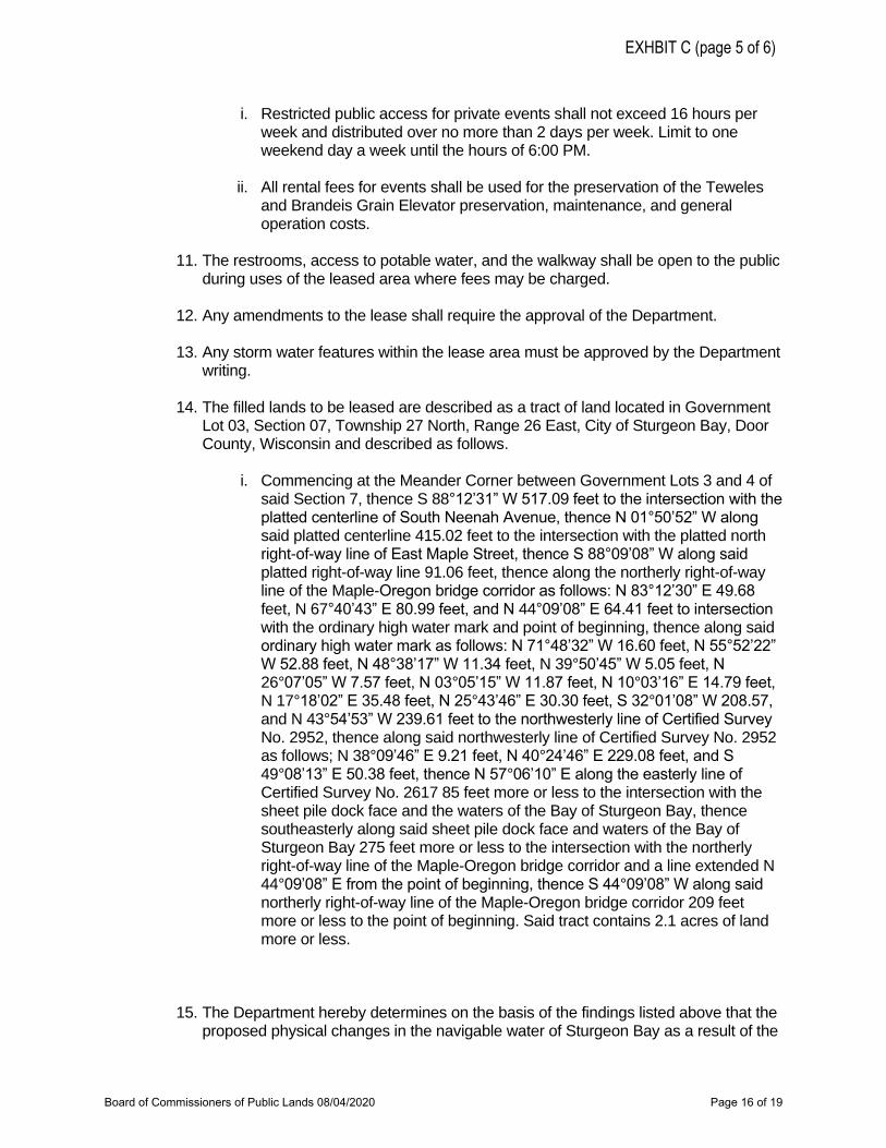
i. Restricted public access for private events shall not exceed 16 hours perweek and distributed over no more than 2 days per week. Limit to oneweekend day a week until the hours of 6:00 PM.
ii. All rental fees for events shall be used for the preservation of the Tewelesand Brandeis Grain Elevator preservation, maintenance, and generaloperation costs.
11. The restrooms, access to potable water, and the walkway shall be open to the publicduring uses of the leased area where fees may be charged.
12. Any amendments to the lease shall require the approval of the Department.
13. Any storm water features within the lease area must be approved by the Departmentwriting.
14. The filled lands to be leased are described as a tract of land located in GovernmentLot 03, Section 07, Township 27 North, Range 26 East, City of Sturgeon Bay, DoorCounty, Wisconsin and described as follows.
i. Commencing at the Meander Corner between Government Lots 3 and 4 ofsaid Section 7, thence S 88°12’31” W 517.09 feet to the intersection with theplatted centerline of South Neenah Avenue, thence N 01°50’52” W alongsaid platted centerline 415.02 feet to the intersection with the platted northright-of-way line of East Maple Street, thence S 88°09’08” W along saidplatted right-of-way line 91.06 feet, thence along the northerly right-of-wayline of the Maple-Oregon bridge corridor as follows: N 83°12’30” E 49.68feet, N 67°40’43” E 80.99 feet, and N 44°09’08” E 64.41 feet to intersectionwith the ordinary high water mark and point of beginning, thence along saidordinary high water mark as follows: N 71°48’32” W 16.60 feet, N 55°52’22”W 52.88 feet, N 48°38’17” W 11.34 feet, N 39°50’45” W 5.05 feet, N26°07’05” W 7.57 feet, N 03°05’15” W 11.87 feet, N 10°03’16” E 14.79 feet,N 17°18’02” E 35.48 feet, N 25°43’46” E 30.30 feet, S 32°01’08” W 208.57,and N 43°54’53” W 239.61 feet to the northwesterly line of Certified SurveyNo. 2952, thence along said northwesterly line of Certified Survey No. 2952as follows; N 38°09’46” E 9.21 feet, N 40°24’46” E 229.08 feet, and S49°08’13” E 50.38 feet, thence N 57°06’10” E along the easterly line ofCertified Survey No. 2617 85 feet more or less to the intersection with thesheet pile dock face and the waters of the Bay of Sturgeon Bay, thencesoutheasterly along said sheet pile dock face and waters of the Bay ofSturgeon Bay 275 feet more or less to the intersection with the northerlyright-of-way line of the Maple-Oregon bridge corridor and a line extended N44°09’08” E from the point of beginning, thence S 44°09’08” W along saidnortherly right-of-way line of the Maple-Oregon bridge corridor 209 feetmore or less to the point of beginning. Said tract contains 2.1 acres of landmore or less.
15. The Department hereby determines on the basis of the findings listed above that theproposed physical changes in the navigable water of Sturgeon Bay as a result of the
EXHBIT C (page 5 of 6)
Board of Commissioners of Public Lands 08/04/2020 Page 16 of 19
execution of a submerged land lease are consistent with the public interest uponcompliance with the conditions specified in Finding I.
FOR-NE-2020-15-01911
WISCONSIN DEPARTMENT OF NATURAL RESOURCES
______________________________________________ 06/16/2020Sarah Szabo DateWater Management Specialist
EXHIBIT C (page 6 of 6)
Board of Commissioners of Public Lands 08/04/2020 Page 17 of 19
July 31, 2020
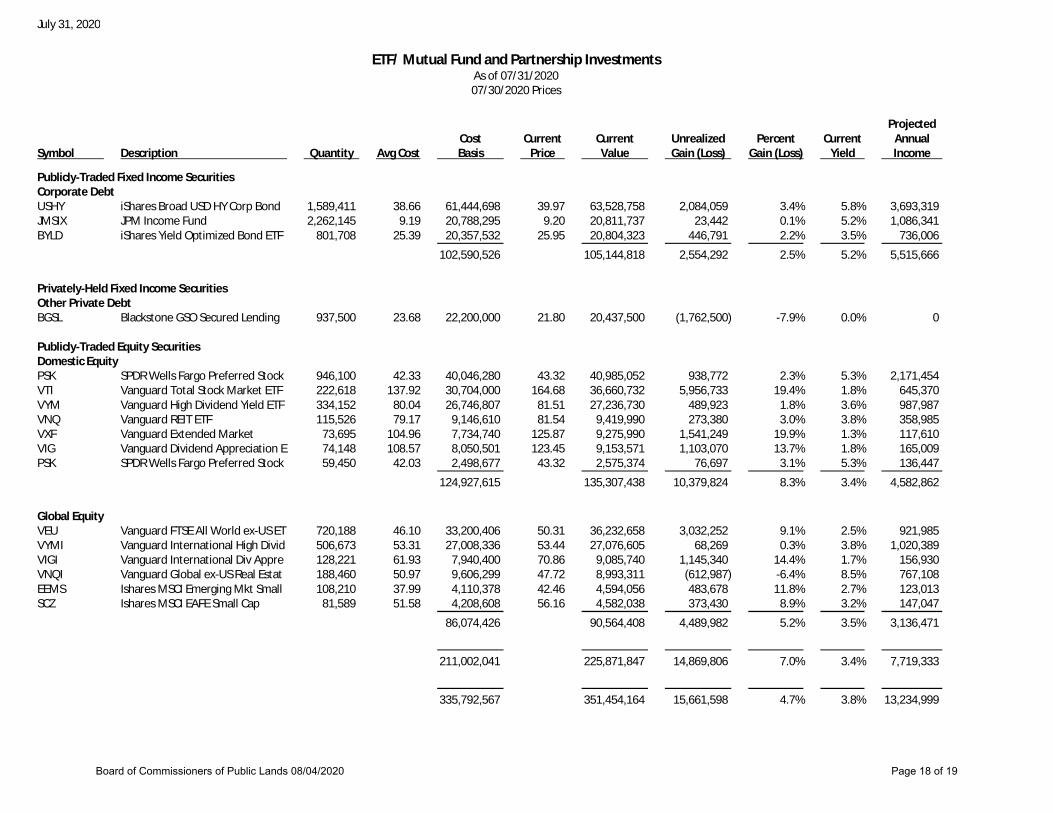
ETF/ Mutual Fund and Partnership InvestmentsAs of 07/31/202007/30/2020 Prices
ProjectedCost Current Current Unrealized Percent Current Annual
Symbol Description Quantity Avg Cost Basis Price Value Gain (Loss) Gain (Loss) Yield Income
Publicly-Traded Fixed Income SecuritiesCorporate DebtUSHY iShares Broad USD HY Corp Bond 1,589,411 38. 66 61,444,698 39. 97 63,528,758 2,084,059 3. 4% 5. 8% 3,693,319JMSIX JPM Income Fund 2,262,145 9. 19 20,788,295 9. 20 20,811,737 23,442 0. 1% 5. 2% 1,086,341BYLD iShares Yield Optimized Bond ETF 801,708 25. 39 20,357,532 25. 95 20,804,323 446,791 2. 2% 3. 5% 736,006
102,590,526 105,144,818 2,554,292 2. 5% 5. 2% 5,515,666
Privately-Held Fixed Income SecuritiesOther Private DebtBGSL Blackstone GSO Secured Lending 937,500 23. 68 22,200,000 21. 80 20,437,500 (1,762,500) -7. 9% 0. 0% 0
Publicly-Traded Equity SecuritiesDomestic EquityPSK SPDR Wells Fargo Preferred Stock 946,100 42. 33 40,046,280 43. 32 40,985,052 938,772 2. 3% 5. 3% 2,171,454VTI Vanguard Total Stock Market ETF 222,618 137. 92 30,704,000 164. 68 36,660,732 5,956,733 19. 4% 1. 8% 645,370VYM Vanguard High Dividend Yield ETF 334,152 80. 04 26,746,807 81. 51 27,236,730 489,923 1. 8% 3. 6% 987,987VNQ Vanguard REIT ETF 115,526 79. 17 9,146,610 81. 54 9,419,990 273,380 3. 0% 3. 8% 358,985VXF Vanguard Extended Market 73,695 104. 96 7,734,740 125. 87 9,275,990 1,541,249 19. 9% 1. 3% 117,610VIG Vanguard Dividend Appreciation E 74,148 108. 57 8,050,501 123. 45 9,153,571 1,103,070 13. 7% 1. 8% 165,009PSK SPDR Wells Fargo Preferred Stock 59,450 42. 03 2,498,677 43. 32 2,575,374 76,697 3. 1% 5. 3% 136,447
124,927,615 135,307,438 10,379,824 8. 3% 3. 4% 4,582,862
Global EquityVEU Vanguard FTSE All World ex-US ET 720,188 46. 10 33,200,406 50. 31 36,232,658 3,032,252 9. 1% 2. 5% 921,985VYMI Vanguard International High Divid 506,673 53. 31 27,008,336 53. 44 27,076,605 68,269 0. 3% 3. 8% 1,020,389VIGI Vanguard International Div Appre 128,221 61. 93 7,940,400 70. 86 9,085,740 1,145,340 14. 4% 1. 7% 156,930VNQI Vanguard Global ex-US Real Estat 188,460 50. 97 9,606,299 47. 72 8,993,311 (612,987) -6. 4% 8. 5% 767,108EEMS Ishares MSCI Emerging Mkt Small 108,210 37. 99 4,110,378 42. 46 4,594,056 483,678 11. 8% 2. 7% 123,013SCZ Ishares MSCI EAFE Small Cap 81,589 51. 58 4,208,608 56. 16 4,582,038 373,430 8. 9% 3. 2% 147,047
86,074,426 90,564,408 4,489,982 5. 2% 3. 5% 3,136,471
211,002,041 225,871,847 14,869,806 7. 0% 3. 4% 7,719,333
335,792,567 351,454,164 15,661,598 4. 7% 3. 8% 13,234,999
Board of Commissioners of Public Lands 08/04/2020 Page 18 of 19
July 31, 2020
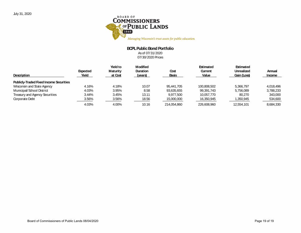
BCPL Public Bond PortfolioAs of 07/31/202007/30/2020 Prices
Yield to Modified Estimated EstimatedExpected Maturity Duration Cost Current Unrealized Annual
Description Yield at Cost (years) Basis Value Gain (Loss) Income
Publicly-Traded Fixed Income SecuritiesWisconsin and State Agency 4. 16% 4. 18% 10. 07 95,441,705 100,808,502 5,366,797 4,018,496Municipal/School District 4. 03% 3. 95% 8. 58 93,635,655 99,391,743 5,756,089 3,788,233Treasury and Agency Securities 3. 44% 3. 45% 13. 11 9,977,500 10,057,770 80,270 343,000Corporate Debt 3. 56% 3. 56% 18. 56 15,000,000 16,350,945 1,350,945 534,600
4. 03% 4. 00% 10. 16 214,054,860 226,608,960 12,554,101 8,684,330
Board of Commissioners of Public Lands 08/04/2020 Page 19 of 19


![Platting 101 - Wilson Cribbs Goren 101.pdf · Smith, seminal platting cases, contain helpful overview of ... Professor James A. Kushner [referred to herein as “Kushner”], is a](https://static.fdocuments.net/doc/165x107/5fc6b3de7fd21b0e173b37a5/platting-101-wilson-cribbs-goren-101pdf-smith-seminal-platting-cases-contain.jpg)


