AERMOD View Release Notes V.8.5 - Addlink Software … · AERMOD View™ Release Notes 2 of 2 Lakes...
44
A A E E R R M M O O D D V V i i e e w w ™ ™ Gaussian Plume Air Dispersion Model - AERMOD Release Notes Versions 8.0, 8.0.5, 8.1, 8.2, and 8.5 Lakes Environmental Software Tel: (519) 746-5995 - Fax: (519) 746-0793 E-mail: [email protected] Web Site: www.webLakes.com © 1996-2014 Lakes Environmental Software
Transcript of AERMOD View Release Notes V.8.5 - Addlink Software … · AERMOD View™ Release Notes 2 of 2 Lakes...

AAEERRMMOODD VViieeww™™ Gaussian Plume Air Dispersion Model - AERMOD
Release Notes
Versions 8.0, 8.0.5, 8.1, 8.2, and 8.5
Lakes Environmental Software
Tel: (519) 746-5995 - Fax: (519) 746-0793
E-mail: [email protected]
Web Site: www.webLakes.com
© 1996-2014 Lakes Environmental Software
AERMOD View™ Release Notes
2 of 2 Lakes Environmental Software
E-mail: [email protected]
Web: www.webLakes.com
AERMOD View™ Version 8.5
Release Notes
January 21, 2014
New Features
Topic Feature Description
Models Latest Releases of US EPA Models Available
The following US EPA Models were released since December 2013 and are
incorporated into AERMOD View Version 8.5:
1. AERMOD Model 13350 (Released Dec 2013)
2. AERMET Model 13350 (Released Dec 2013)
Note: AERMOD 13350 will not run using met data created using
AERMET 11059 or earlier. Old met data must be re-processed using a
more recent version of AERMET (preferably 13350), or the modeler must
use an older version of the AERMOD model.
AERMOD
MPI
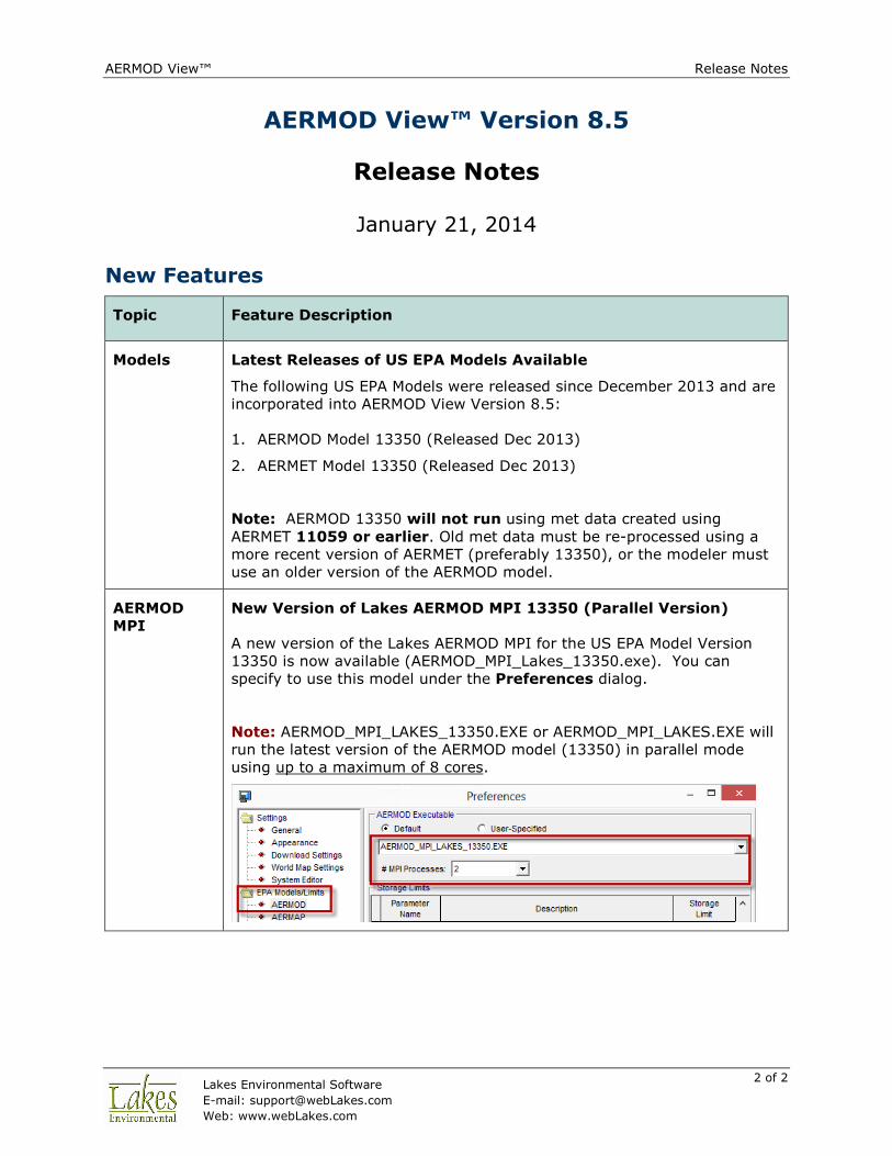
New Version of Lakes AERMOD MPI 13350 (Parallel Version)
A new version of the Lakes AERMOD MPI for the US EPA Model Version
13350 is now available (AERMOD_MPI_Lakes_13350.exe). You can
specify to use this model under the Preferences dialog.
Note: AERMOD_MPI_LAKES_13350.EXE or AERMOD_MPI_LAKES.EXE will
run the latest version of the AERMOD model (13350) in parallel mode
using up to a maximum of 8 cores.

AERMOD View™ Release Notes
3 of 3 Lakes Environmental Software
E-mail: [email protected]
Web: www.webLakes.com
Topic Feature Description
Control
Pathway
New NO2 Modeling Methods
The U.S. EPA incorporated two new options for modeling NO2: the
Ambient Ratio Method (ARM) and the Ambient Ratio Method – 2
(ARM2). ARM can be modeled as a Regulatory Default option while ARM2
is a non-default BETA option.
Control
Pathway
Vary Background Ozone by Downwind Sector
Introduced with AERMOD 13350, background ozone concentrations can
now vary by downwind sector. Sectors are defined by the flow vector
(direction the wind blows towards). The original background ozone
variance options (including hourly emission files) are applied to each
individual sector.
AERMOD View™ Release Notes
4 of 4 Lakes Environmental Software
E-mail: [email protected]
Web: www.webLakes.com
Topic Feature Description
Control
Pathway
Background Ozone Options Moved
The Background Ozone options used with the OLM and PVMRM model
options have been relocated to their own window (CO Pathway –
Background Ozone).
Control
Pathway
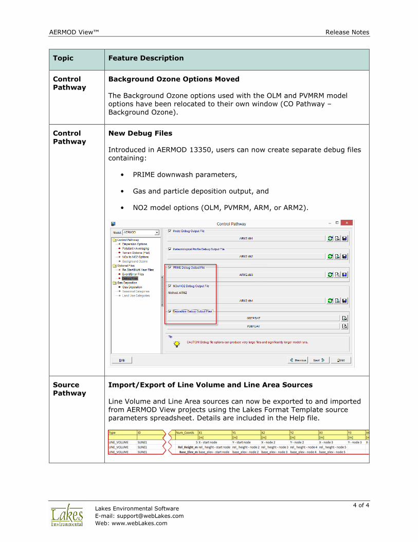
New Debug Files
Introduced in AERMOD 13350, users can now create separate debug files
containing:
• PRIME downwash parameters,
• Gas and particle deposition output, and
• NO2 model options (OLM, PVMRM, ARM, or ARM2).
Source
Pathway
Import/Export of Line Volume and Line Area Sources
Line Volume and Line Area sources can now be exported to and imported
from AERMOD View projects using the Lakes Format Template source
parameters spreadsheet. Details are included in the Help file.
AERMOD View™ Release Notes
5 of 5 Lakes Environmental Software
E-mail: [email protected]
Web: www.webLakes.com
Topic Feature Description
Source
Pathway
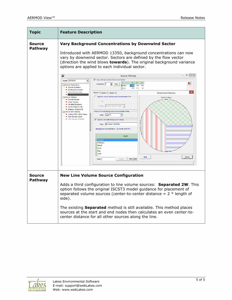
Vary Background Concentrations by Downwind Sector
Introduced with AERMOD 13350, background concentrations can now
vary by downwind sector. Sectors are defined by the flow vector
(direction the wind blows towards). The original background variance
options are applied to each individual sector.
Source
Pathway
New Line Volume Source Configuration
Adds a third configuration to line volume sources: Separated 2W. This
option follows the original ISCST3 model guidance for placement of
separated volume sources (center-to-center distance = 2 * length of
side).
The existing Separated method is still available. This method places
sources at the start and end nodes then calculates an even center-to-
center distance for all other sources along the line.
AERMOD View™ Release Notes
6 of 6 Lakes Environmental Software
E-mail: [email protected]
Web: www.webLakes.com
Topic Feature Description
Source
Pathway
Modified Seasonal Labels for Southern Hemisphere
When the Map Projection is set to the Southern Hemisphere, all seasonal
labels (e.g., Background Concentrations, Variable Emission Rates) are
reversed and display what months apply to each value.
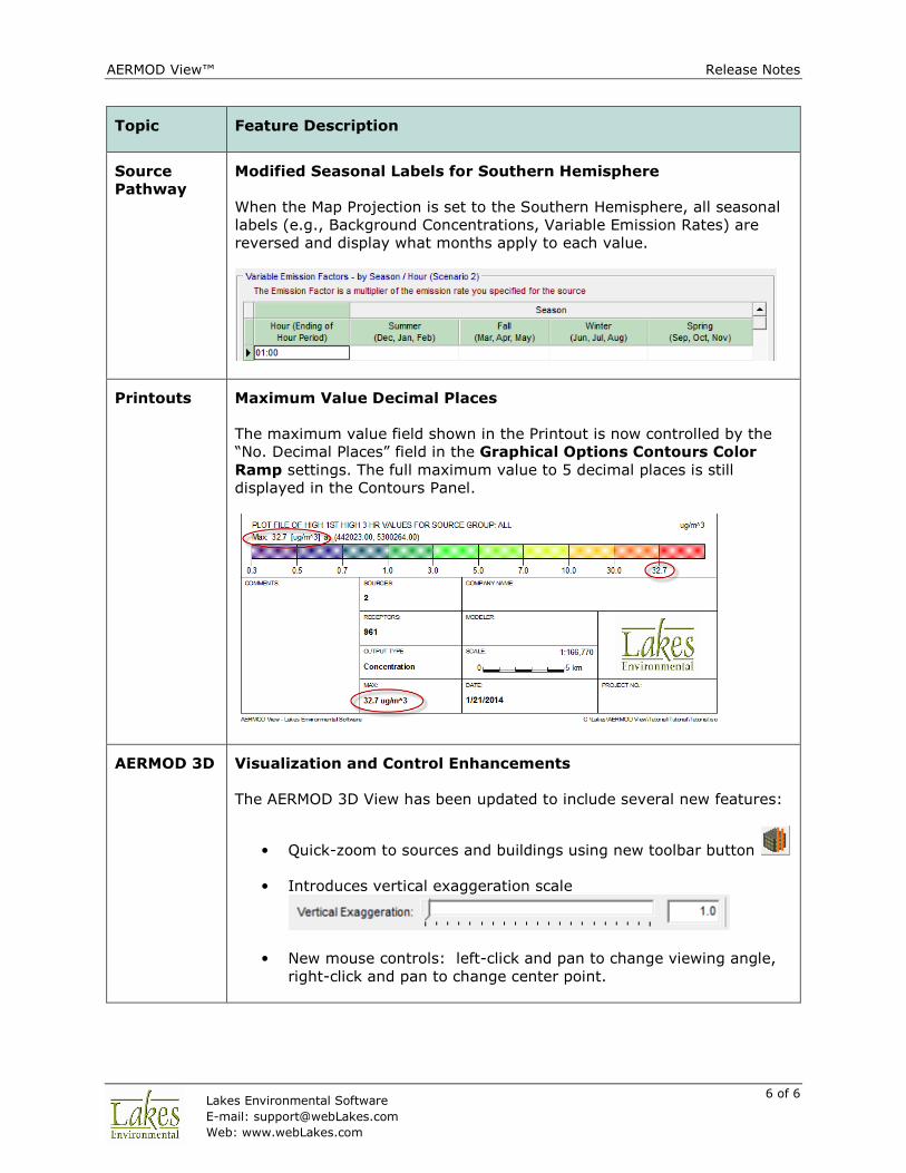
Printouts Maximum Value Decimal Places
The maximum value field shown in the Printout is now controlled by the
“No. Decimal Places” field in the Graphical Options Contours Color
Ramp settings. The full maximum value to 5 decimal places is still
displayed in the Contours Panel.
AERMOD 3D Visualization and Control Enhancements
The AERMOD 3D View has been updated to include several new features:
• Quick-zoom to sources and buildings using new toolbar button
• Introduces vertical exaggeration scale
• New mouse controls: left-click and pan to change viewing angle,
right-click and pan to change center point.

AERMOD View™ Release Notes
7 of 7 Lakes Environmental Software
E-mail: [email protected]
Web: www.webLakes.com
Topic Feature Description
Met View Export SFC & PFL Files to CSV and Excel
Surface (.SFC) and Profile (.PFL) files can be exported from Met View to
CSV or Excel spreadsheet. The exported file contains all column headers
and unit descriptions.
Export button is available in Met View window.
AERMET
View
New US EPA AERMET Model Version 13350
On December 16, 2013, the US EPA released a new version of the
AERMET model (13350). For a complete description of the changes,
please see the US EPA Model Change Bulletin #4 (MCB#4).
AERMOD View™ Release Notes
8 of 8 Lakes Environmental Software
E-mail: [email protected]
Web: www.webLakes.com
Topic Feature Description
AERMET
View
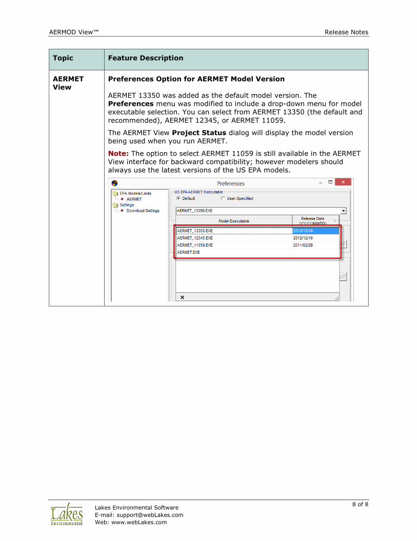
Preferences Option for AERMET Model Version
AERMET 13350 was added as the default model version. The
Preferences menu was modified to include a drop-down menu for model
executable selection. You can select from AERMET 13350 (the default and
recommended), AERMET 12345, or AERMET 11059.
The AERMET View Project Status dialog will display the model version
being used when you run AERMET.
Note: The option to select AERMET 11059 is still available in the AERMET
View interface for backward compatibility; however modelers should
always use the latest versions of the US EPA models.
AERMOD View™ Release Notes
9 of 9 Lakes Environmental Software
E-mail: [email protected]
Web: www.webLakes.com
Topic Feature Description
AERMET
View
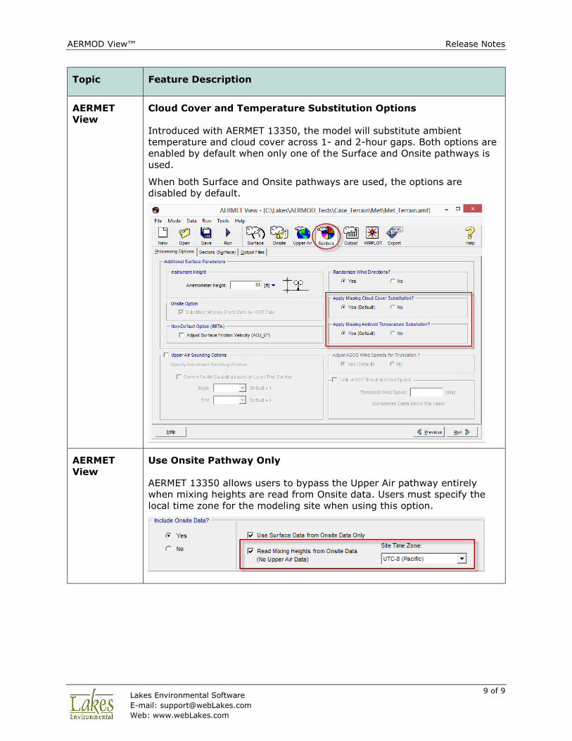
Cloud Cover and Temperature Substitution Options
Introduced with AERMET 13350, the model will substitute ambient
temperature and cloud cover across 1- and 2-hour gaps. Both options are
enabled by default when only one of the Surface and Onsite pathways is
used.
When both Surface and Onsite pathways are used, the options are
disabled by default.
AERMET
View
Use Onsite Pathway Only
AERMET 13350 allows users to bypass the Upper Air pathway entirely
when mixing heights are read from Onsite data. Users must specify the
local time zone for the modeling site when using this option.
AERMOD View™ Release Notes
10 of 10 Lakes Environmental Software
E-mail: [email protected]
Web: www.webLakes.com
Topic Feature Description
AERMET
View
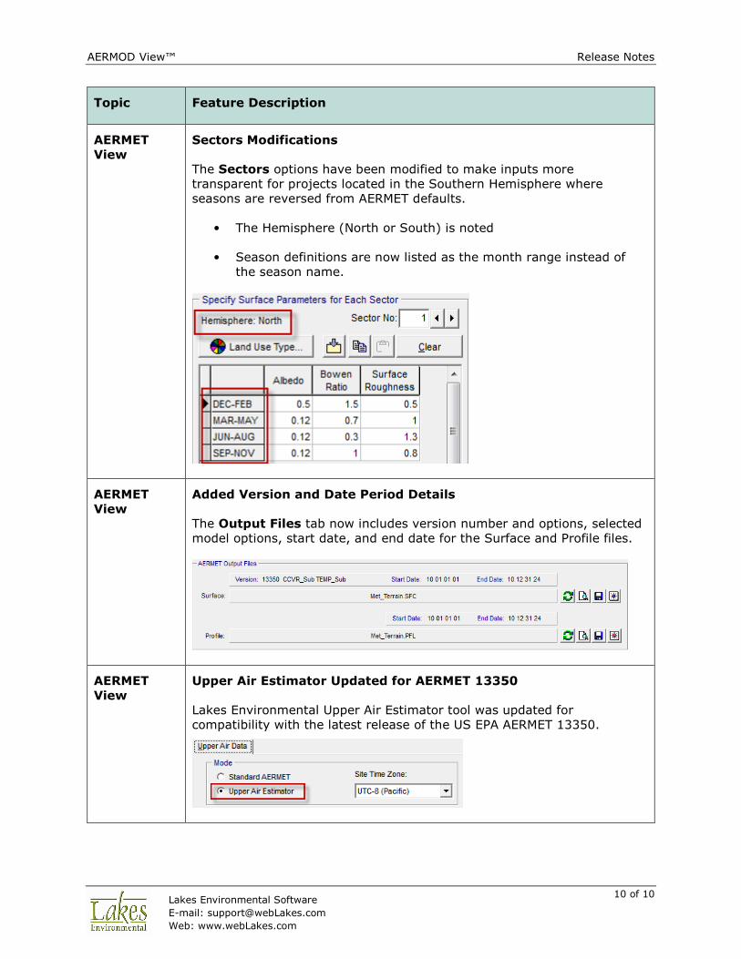
Sectors Modifications
The Sectors options have been modified to make inputs more
transparent for projects located in the Southern Hemisphere where
seasons are reversed from AERMET defaults.
• The Hemisphere (North or South) is noted
• Season definitions are now listed as the month range instead of
the season name.
AERMET
View
Added Version and Date Period Details
The Output Files tab now includes version number and options, selected
model options, start date, and end date for the Surface and Profile files.
AERMET
View
Upper Air Estimator Updated for AERMET 13350
Lakes Environmental Upper Air Estimator tool was updated for
compatibility with the latest release of the US EPA AERMET 13350.

AERMOD View™ Release Notes
11 of 11 Lakes Environmental Software
E-mail: [email protected]
Web: www.webLakes.com
Fixed Issues
Topic Issue Description
Save
Project As
Renamed Met Data Files
When meteorological data files had an identical name to a project, the file
names were changed when running the Save Project As menu option. The
option now maintains the original path to the met data files.
Control
Pathway
Ozone File Maker Update
The “Auto Populate for Missing Hours” option in the Hourly Ozone
Concentration File Maker utility was removed. When building the file, the
utility automatically adds a missing indicator (-99) to all blank cells.
Source
Pathway
Gas & Particle Data Fixes
Fixed a bug which did not write deposition parameters to sources with IDs
longer than 10 characters. Also fixed an issue with the Copy and Paste
functions.
Source
Pathway
Line Volume Source Coordinates
Expanded the number of source node coordinates written to the model
input file so coordinates of individual sources along the line can be
recreated.
Reports Missing Fields
Fields like Pollutant Type in the Control Pathway report went missing for
certain values. This has been fixed.
Contours
Panel
Shortened Plotfile List
Removed the full project folder path from the Plotfile List menu to make
file names shorter. Previous versions occasionally had issues with paths
that extended beyond the available space.
Color Ramp Duplicate Title
Fixed an issue with the original Color Ramp title remaining after
renaming.

AERMOD View™ Release Notes
12 of 12 Lakes Environmental Software
E-mail: [email protected]
Web: www.webLakes.com
Topic Issue Description
WRPLOT
View
Miscellaneous Updates
Updates include:
• New default “Files of type” set to All Files when adding files
• Setting Wind Classes display to show 2 decimal places and refined
conversions between m/s and knots.
• Bug fixes to the Data File Info panel when multiple files or years of
data are analyzed. Fixes include displaying the proper number of
missing records and total number of hours when the Date Range is
modified.
• Inclusion of February 29 in the Specify Days option when a leap
year is present.
• All percentages normalized to the total number of hours. Previous
versions would correct calm frequencies to remove missing
records.
• Modification to reading TD-3505/ISHD files to match code from
AERMET. The program now reads observations found between :30
of the previous hour and :01 of the current hour.
• Added XLSX support to the Import Surface Data from Excel utility.
• Modifications to the Years and Time Range fields to allow subsets
of multiple years and overnight hours to be analyzed.

AERMOD View™ Release Notes
13 of 13 Lakes Environmental Software
E-mail: [email protected]
Web: www.webLakes.com
AERMOD View™ Version 8.2
Release Notes
April 18, 2013
New Features
Topic Feature Description
Install Web License Automatically Deactivated During Uninstall
If you have a Web License and you uninstall AERMOD View using the
uninstall feature from the Windows Control Panel then your web license
will be automatically deactivated as long as an internet connection was
available during the uninstall.
HASP
License
HASP Key License Requires Update
AERMOD View Version 8.2 requires the renewal/update of the HASP Key
License.
If you are under current maintenance and you have the HASP Key license,
than you will receive your HASP renew code with the release email.
Instructions on how to update/activate your HASP Key license are
provided in the installation instructions document available in the update
site.

AERMOD View™ Release Notes
14 of 14 Lakes Environmental Software
E-mail: [email protected]
Web: www.webLakes.com
Topic Feature Description
Reports Updated Reports Template and New Results Summary
The Reports template was updated to include new model features. The
Results Summary was also added for standard or multi-chemical runs.
The report contains tables summarizing model output concentrations or
deposition fluxes.
Preferences Select Default Text Editor
Users can now specify the default text editor for opening project input and
output files under the File | Preferences options.
AERMOD View™ Release Notes
15 of 15 Lakes Environmental Software
E-mail: [email protected]
Web: www.webLakes.com
Topic Feature Description
Labels Control Labels for Large Numbers of Objects
Previous versions of AERMOD View restricted control of individual labels to
the first 1,000 objects of a single type for performance purposes. Users
can now select the “Show All” checkbox on the Labels Tree Menu to
control individual labels of all objects.
Base Maps Transparency Option for Raster Images
Users can set image transparency when importing raster image base
maps.
Source
Pathway
NO2/NOx Ratios for Line-Area and Line-Volume Sources
In-Stack NO2/NOx ratios are now available for Line Area and Line Volume
source types. The specified ratio applies to all sources in the line.
Source
Pathway
Improved Error Handling When Importing Deposition Data
A list of errors is available when importing deposition parameters to the
Gas & Particle Data source options.
Met
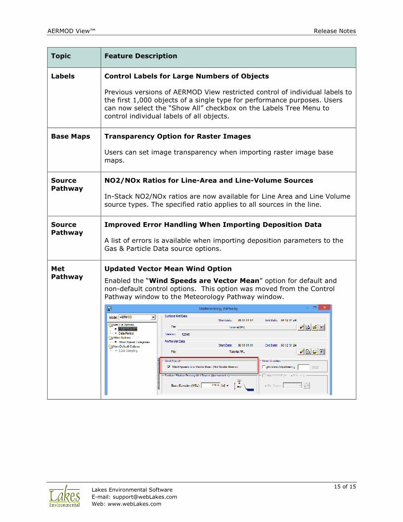
Pathway
Updated Vector Mean Wind Option
Enabled the “Wind Speeds are Vector Mean” option for default and
non-default control options. This option was moved from the Control
Pathway window to the Meteorology Pathway window.
AERMOD View™ Release Notes
16 of 16 Lakes Environmental Software
E-mail: [email protected]
Web: www.webLakes.com
Topic Feature Description
Met
Pathway
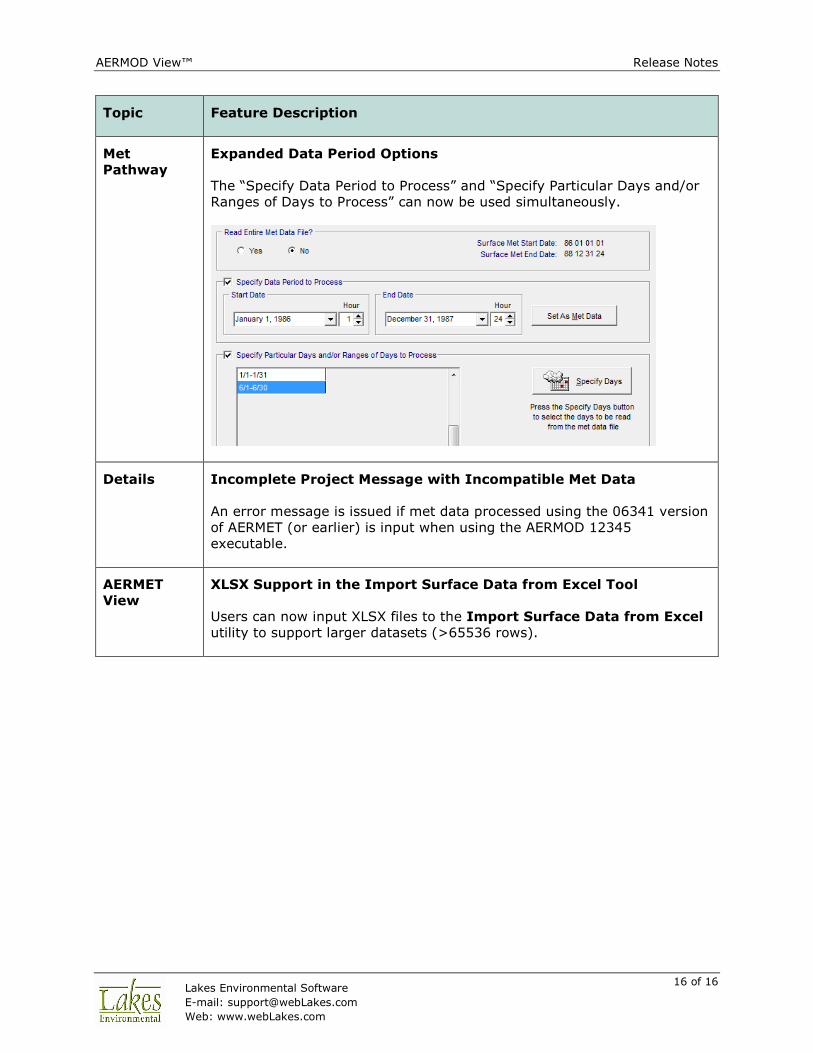
Expanded Data Period Options
The “Specify Data Period to Process” and “Specify Particular Days and/or
Ranges of Days to Process” can now be used simultaneously.
Details Incomplete Project Message with Incompatible Met Data
An error message is issued if met data processed using the 06341 version
of AERMET (or earlier) is input when using the AERMOD 12345
executable.
AERMET
View
XLSX Support in the Import Surface Data from Excel Tool
Users can now input XLSX files to the Import Surface Data from Excel
utility to support larger datasets (>65536 rows).

AERMOD View™ Release Notes
17 of 17 Lakes Environmental Software
E-mail: [email protected]
Web: www.webLakes.com
Fixed Issues
Topic Issue Description
Control
Pathway
Fixed BETA Options Error
Fixed an issue where the program looked for user-specified Low Wind
Parameters associated with LOWWIND2 even when the LOWWIND1 option
was selected.
Source
Pathway
Display Base Elevation for Line-Area Sources
Fixed an issue in the Source Summary table where the Base Elevation
column was empty for Line Area sources.
Source
Pathway
Corrected Source Import for Line-Area Sources
The Import Sources routine was fixed to properly import all source
parameters from Line-Area source types.
Risk Mode Various Risk Mode Options
• Multi-Tier grid not displayed when created using the Risk Mode |
Risk Grid… menu option.
• Copy-and-paste functions of Risk Emission Phase Data menu
were not working properly.
Terrain
Processor
Error Converting NED GridFloat to GeoTIFF
A component was missing that was necessary for converting NED terrain
data downloaded from WebGIS from its native GridFloat format to the
AERMAP-accepted GeoTIFF format. The missing component is now
included in the install package.
Multi-
Chemical
Utility
Urban Groups with Line-Area and Line-Volume Sources
Resolved an issue where the URBANSRC keyword was not correctly
applied to line sources.
AERMET
View
Multiple STABLEBL Keywords
AERMET View now accepts the BETA adjust U* option and the ONSITE
Bulk Richardson Number scheme option in the same run. The previous
release only allowed the STABLEBL keyword to be used once.
AERMOD View™ Release Notes
18 of 18 Lakes Environmental Software
E-mail: [email protected]
Web: www.webLakes.com
AERMOD View™ Version 8.1
Release Notes
January 25, 2013
New Features
Topic Feature Description
Install Compatibility with Windows 8, 32-Bit and 64-Bit
AERMOD View Version 8.1 is compatible with Microsoft Windows 8, 32-bit
and 64-bit versions.
AERMOD MPI (Parallel Version) requires the installation of MPICH2, which
requires that .NET Framework 3.5 is installed in your computer. As
opposed to Windows 7 and XP, Windows 8 does not automatically install
.NET Framework 3.5. The user must manually select it before installing
MPICH2 1.4.1. Instructions are provided in the AERMOD View Installation
Notes.
Models Latest Releases of US EPA Models Available
The following US EPA Models were released since Dec/2012 and are
incorporated into AERMOD View Version 8.1:
3. AERMOD Model 12345 (Released Dec 2012)
4. AERMET Model 12345 (Released Dec 2012)
5. AERSURFACE Model 13016 (Released Jan 2013)
AERMOD View™ Release Notes
19 of 19 Lakes Environmental Software
E-mail: [email protected]
Web: www.webLakes.com
Topic Feature Description
AERMOD
MPI
New Version of Lakes AERMOD MPI 12345 (Parallel Version)
A new version of the Lakes AERMOD MPI for the US EPA Model Version
12345 is now available (AERMOD_MPI_Lakes_12345.exe). You can
specify to use this model under the Preferences dialog.
Note: AERMOD_MPI_LAKES_12345.EXE or AERMOD_MPI_LAKES.EXE will
run the latest version of the AERMOD model (12345) in parallel mode
using up to a maximum of 8 cores.
Control
Pathway
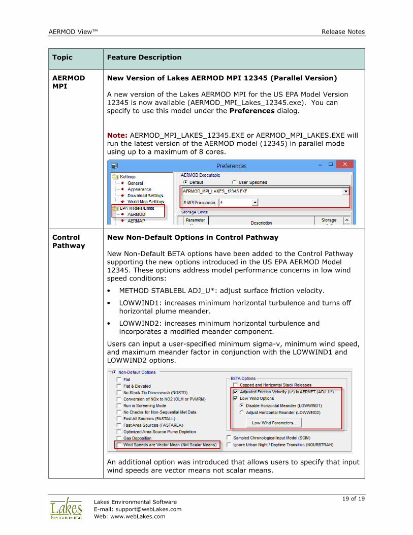
New Non-Default Options in Control Pathway
New Non-Default BETA options have been added to the Control Pathway
supporting the new options introduced in the US EPA AERMOD Model
12345. These options address model performance concerns in low wind
speed conditions:
• METHOD STABLEBL ADJ_U*: adjust surface friction velocity.
• LOWWIND1: increases minimum horizontal turbulence and turns off
horizontal plume meander.
• LOWWIND2: increases minimum horizontal turbulence and
incorporates a modified meander component.
Users can input a user-specified minimum sigma-v, minimum wind speed,
and maximum meander factor in conjunction with the LOWWIND1 and
LOWWIND2 options.
An additional option was introduced that allows users to specify that input
wind speeds are vector means not scalar means.
AERMOD View™ Release Notes
20 of 20 Lakes Environmental Software
E-mail: [email protected]
Web: www.webLakes.com
Topic Feature Description
Source
Pathway
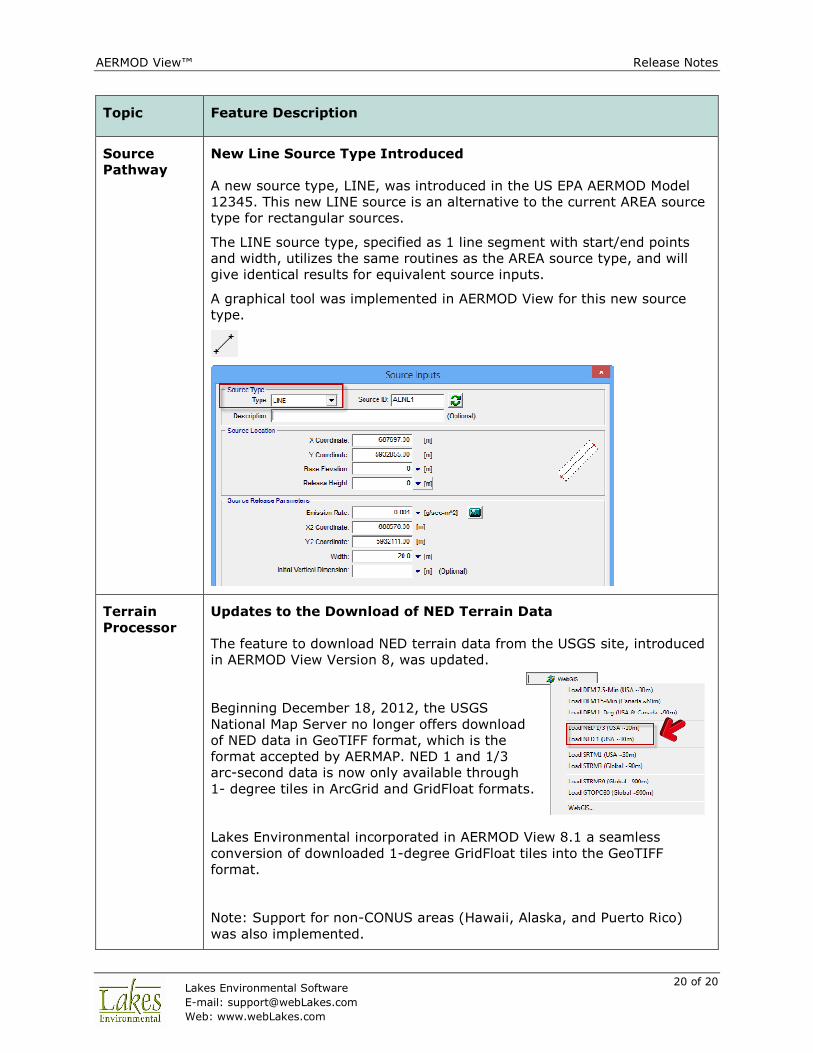
New Line Source Type Introduced
A new source type, LINE, was introduced in the US EPA AERMOD Model
12345. This new LINE source is an alternative to the current AREA source
type for rectangular sources.
The LINE source type, specified as 1 line segment with start/end points
and width, utilizes the same routines as the AREA source type, and will
give identical results for equivalent source inputs.
A graphical tool was implemented in AERMOD View for this new source
type.
Terrain
Processor
Updates to the Download of NED Terrain Data
The feature to download NED terrain data from the USGS site, introduced
in AERMOD View Version 8, was updated.
Beginning December 18, 2012, the USGS
National Map Server no longer offers download
of NED data in GeoTIFF format, which is the
format accepted by AERMAP. NED 1 and 1/3
arc-second data is now only available through
1- degree tiles in ArcGrid and GridFloat formats.
Lakes Environmental incorporated in AERMOD View 8.1 a seamless
conversion of downloaded 1-degree GridFloat tiles into the GeoTIFF
format.
Note: Support for non-CONUS areas (Hawaii, Alaska, and Puerto Rico)
was also implemented.
AERMOD View™ Release Notes
21 of 21 Lakes Environmental Software
E-mail: [email protected]
Web: www.webLakes.com
Topic Feature Description
Met
Pathway
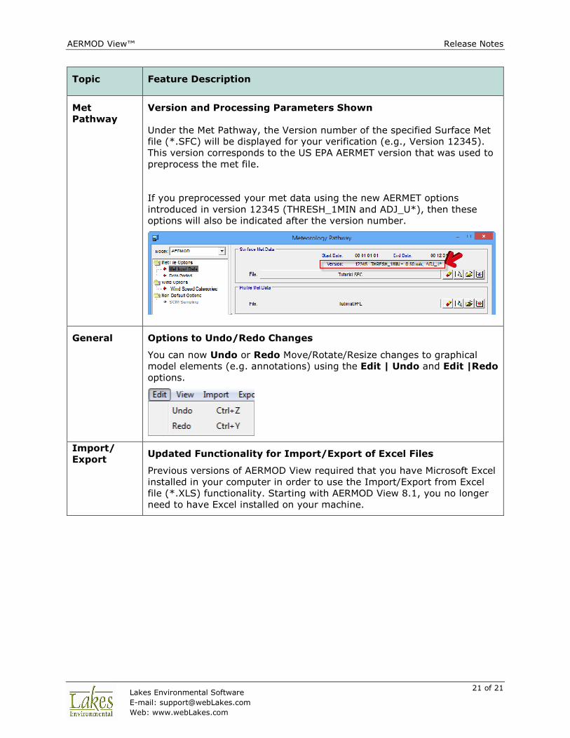
Version and Processing Parameters Shown
Under the Met Pathway, the Version number of the specified Surface Met
file (*.SFC) will be displayed for your verification (e.g., Version 12345).
This version corresponds to the US EPA AERMET version that was used to
preprocess the met file.
If you preprocessed your met data using the new AERMET options
introduced in version 12345 (THRESH_1MIN and ADJ_U*), then these
options will also be indicated after the version number.
General Options to Undo/Redo Changes
You can now Undo or Redo Move/Rotate/Resize changes to graphical
model elements (e.g. annotations) using the Edit | Undo and Edit |Redo
options.
Import/
Export Updated Functionality for Import/Export of Excel Files
Previous versions of AERMOD View required that you have Microsoft Excel
installed in your computer in order to use the Import/Export from Excel
file (*.XLS) functionality. Starting with AERMOD View 8.1, you no longer
need to have Excel installed on your machine.
AERMOD View™ Release Notes
22 of 22 Lakes Environmental Software
E-mail: [email protected]
Web: www.webLakes.com
Topic Feature Description
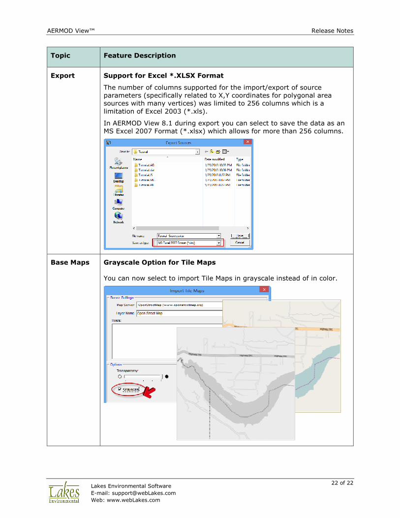
Export Support for Excel *.XLSX Format
The number of columns supported for the import/export of source
parameters (specifically related to X,Y coordinates for polygonal area
sources with many vertices) was limited to 256 columns which is a
limitation of Excel 2003 (*.xls).
In AERMOD View 8.1 during export you can select to save the data as an
MS Excel 2007 Format (*.xlsx) which allows for more than 256 columns.
Base Maps Grayscale Option for Tile Maps
You can now select to import Tile Maps in grayscale instead of in color.
AERMOD View™ Release Notes
23 of 23 Lakes Environmental Software
E-mail: [email protected]
Web: www.webLakes.com
Topic Feature Description
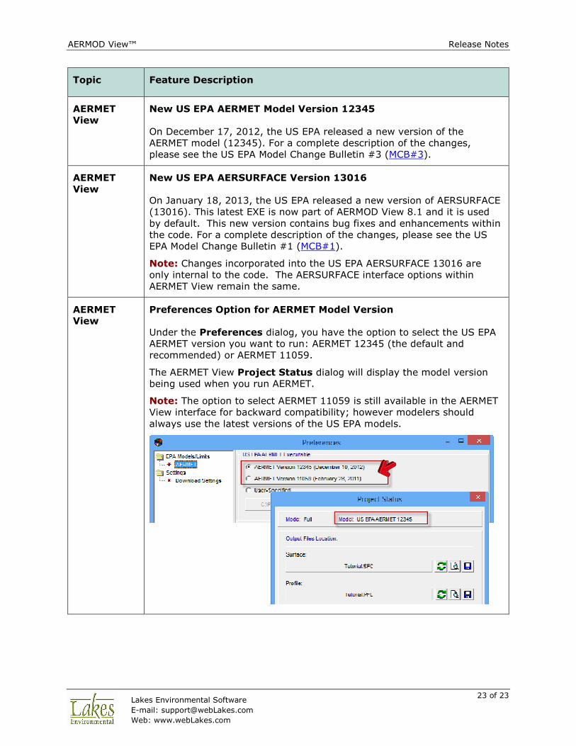
AERMET
View
New US EPA AERMET Model Version 12345
On December 17, 2012, the US EPA released a new version of the
AERMET model (12345). For a complete description of the changes,
please see the US EPA Model Change Bulletin #3 (MCB#3).
AERMET
View
New US EPA AERSURFACE Version 13016
On January 18, 2013, the US EPA released a new version of AERSURFACE
(13016). This latest EXE is now part of AERMOD View 8.1 and it is used
by default. This new version contains bug fixes and enhancements within
the code. For a complete description of the changes, please see the US
EPA Model Change Bulletin #1 (MCB#1).
Note: Changes incorporated into the US EPA AERSURFACE 13016 are
only internal to the code. The AERSURFACE interface options within
AERMET View remain the same.
AERMET
View
Preferences Option for AERMET Model Version
Under the Preferences dialog, you have the option to select the US EPA
AERMET version you want to run: AERMET 12345 (the default and
recommended) or AERMET 11059.
The AERMET View Project Status dialog will display the model version
being used when you run AERMET.
Note: The option to select AERMET 11059 is still available in the AERMET
View interface for backward compatibility; however modelers should
always use the latest versions of the US EPA models.

AERMOD View™ Release Notes
24 of 24 Lakes Environmental Software
E-mail: [email protected]
Web: www.webLakes.com
Topic Feature Description
AERMET
View
Threshold Wind Speed Option for AERMINUTE Output
Introduced with AERMET 12345 is the option to specify a wind speed
threshold for 1-minute ASOS winds output by AERMINUTE. This value will
be used by AERMET in Stage 3.
There is no default value; however, a warning message will be generated
if the user-specified threshold is greater than 0.5 m/s, and a fatal error
message will be generated if the user-specified threshold is less than zero
or greater than 1.0.
AERMET
View
AERMINUTE – IFW Installation Date
Now the AERMINUTE Utility automatically checks if the ASOS surface
station being used is part of the Ice Free Winds (IFW) group and if so, it
automatically specifies the date of the installation.
AERMOD View™ Release Notes
25 of 25 Lakes Environmental Software
E-mail: [email protected]
Web: www.webLakes.com
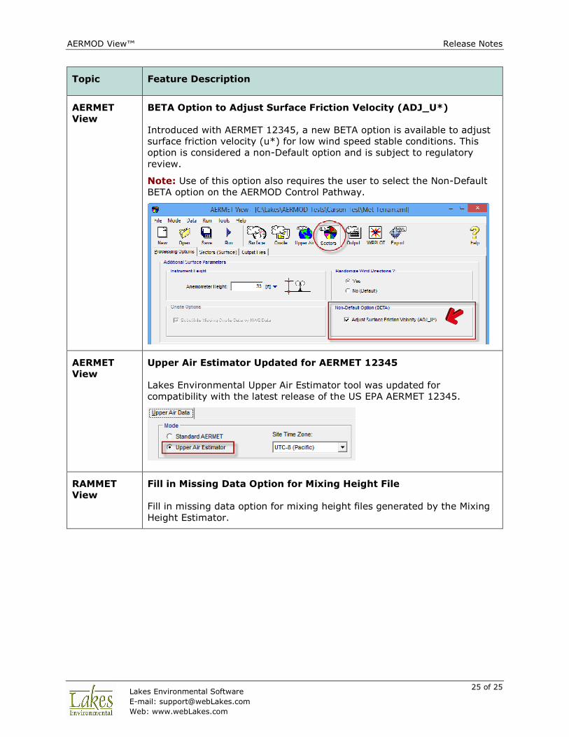
Topic Feature Description
AERMET
View
BETA Option to Adjust Surface Friction Velocity (ADJ_U*)
Introduced with AERMET 12345, a new BETA option is available to adjust
surface friction velocity (u*) for low wind speed stable conditions. This
option is considered a non-Default option and is subject to regulatory
review.
Note: Use of this option also requires the user to select the Non-Default
BETA option on the AERMOD Control Pathway.
AERMET
View
Upper Air Estimator Updated for AERMET 12345
Lakes Environmental Upper Air Estimator tool was updated for
compatibility with the latest release of the US EPA AERMET 12345.
RAMMET
View
Fill in Missing Data Option for Mixing Height File
Fill in missing data option for mixing height files generated by the Mixing
Height Estimator.

AERMOD View™ Release Notes
26 of 26 Lakes Environmental Software
E-mail: [email protected]
Web: www.webLakes.com
Fixed Issues
Topic Issue Description
Base Maps Base Maps Not Transferred to the New Saved Project As
AERMOD View 8.0.5 did not transfer the reference to imported base
maps/tile maps to the new project when using the “Save As Project”
option. This issue has been fixed in AERMOD View 8.1.
Source
Pathway
Gas & Particle Data – Method 2 with Non-Default Option
Issue of not being able to select the Non-Default Method 2 option under
the Source Pathway – Gas & Particle Data window with only the Non-
Default option selected in the Control Pathway was resolved.
MAKEMET
Utility
Surface Roughness Value for Water Fixed
Under the MAKEMET Utility (accessed from the Tools menu), when the
water land use category was selected, a surface roughness of 0.0 was
being specified instead of 0.0001 due to the limitation on the number of
decimal places allowed in the field. This issue has been resolved.
AERMOD View™ Release Notes
27 of 27 Lakes Environmental Software
E-mail: [email protected]
Web: www.webLakes.com
AERMOD View™ Version 8.0.5
Release Notes
October 11, 2012
New Features
Topic Feature Description
Graphical
Options
Colored Contour Lines
Contour Lines and Terrain Contour Lines can now be colored to match the
contour level colors. This option is available under the Graphical
Options – Smoothing panel.
Buildings Map Layers Available under Preview in Building Inputs Dialog
The Preview display of the Building Inputs window now includes all base
maps as layers.
AERMOD View™ Release Notes
28 of 28 Lakes Environmental Software
E-mail: [email protected]
Web: www.webLakes.com
Topic Feature Description
Export New Google Earth Export Options
The Export to Google Earth feature now includes:
• Plant Boundary Receptors
• Exporting contour lines only, without shading
Source
Pathway
In-Stack NO2/NOx Ratio List Update
Enhanced the In-Stack NO2/Nox Ratio table to display more digits.
Meteorology
Pathway
Onsite Station Information Extracted from SFC Met File
Onsite station ID number and year are automatically populated if the SFC
file contains onsite station information.
Details Additional Warnings in Details
AERMOD View will now warn you if the urban dispersion option is enabled
and a population value is not input for urban groups.
AERMOD View™ Release Notes
29 of 29 Lakes Environmental Software
E-mail: [email protected]
Web: www.webLakes.com
Topic Feature Description
AERMET
View
Sectors and 3-Km Radius Exported to Google Earth
When exporting AERMET View project information to Google Earth, a 3-
kilometer radius and outline of specified sectors is now included for the
surface met station and/or onsite met station. This feature is especially
useful for users that need to specify the land use type and sectors by
hand.
AERMET
View
Improvements for the Onsite Data Formatting Options
When identifying onsite variables, single- and multi-level variables are
now listed in a single table so that users can specify any order.
Also implemented is the full description for each onsite variable and
expected units.
The unit for the onsite precipitation variable “PRCP” was changed from
mm to mm*100 as required by the US EPA AERMET dated 11059.

AERMOD View™ Release Notes
30 of 30 Lakes Environmental Software
E-mail: [email protected]
Web: www.webLakes.com
Topic Feature Description
AERMET
View
Full Descriptions for QA Variables
Surface and Upper Air Variables that you select for QA now display their
full description and expected units.
AERMET
View
Disabled Unsupported Options for Onsite Only Option
If the “Surface Data from Onsite Only” option is enabled, model options
that only apply to hourly surface data are disabled including anemometer
height and data substitution selection.
AERMET
View
Additional Warnings for AERMET View
Additional warning messages were implemented related to the adjustment
from GMT to local standard time (LST) for hourly surface data, onsite
data, and upper air data.

AERMOD View™ Release Notes
31 of 31 Lakes Environmental Software
E-mail: [email protected]
Web: www.webLakes.com
Fixed Issues
Topic Issue Description
Terrain
Processor
Automated Download of NED Terrain Data Connection Issue
Starting in AERMOD View Version 8.0 users can now automatically
download USGS National Elevation Dataset (NED) terrain data files for
projects located in the United States.
On the first week of October 2012, the USGS changed the server
parameters and settings that allowed third party programs to
automatically download the NED terrain data from their servers. Users of
AERMOD View trying to download the NED terrain data started receiving
messages that a connection with server could not be established.
AERMOD View Version 8.0.5 contains a solution to this issue.
NOTE: This feature is only available for users with current maintenance.
If you are receiving this update as part of your maintenance, once your
maintenance expires, you will no longer have access to this feature.
AERMOD View™ Release Notes
32 of 32 Lakes Environmental Software
E-mail: [email protected]
Web: www.webLakes.com
Topic Issue Description
Reports Generate Reports Error
Version 8.0 contained a bug which prevented AERMOD View from creating
or displaying reports. This issue has been resolved.
Output
Pathway
Creation of the Exceedance Plot File Fixed
Fixed a bug in which the Threshold Violation File was created but the
Exceedance Plot File was empty.
Base Maps Raster Image Optimization
Updated the Import | Base Maps | Raster Images option to resolve
two issues:
1. Coordinates embedded in geo-referenced GeoTIFF images are now
read by the program even if a corresponding .tfw file is not
present.
2. The preview display of the Import Base Maps window would not
show some large base maps.
Multi-
Chemical
Utility
Multi-Chemical Utility Storage/Memory Error
Fixed a problem resulting in Multi-Chemical runs failing due to a lack of
storage or memory.
Buildings Building Tiers in Wrong Order
Resolved a bug in which building tiers were ordered differently in the main
display and the Building Inputs window. Tiers are now ordered
automatically from shortest to tallest.
AERMOD View™ Release Notes
33 of 33 Lakes Environmental Software
E-mail: [email protected]
Web: www.webLakes.com
Topic Issue Description
Source
Pathway
Adding Line Source Nodes
Resolved an issue where adding line source nodes in the Source window
created a row which could not be selected.
AERMOD
MPI
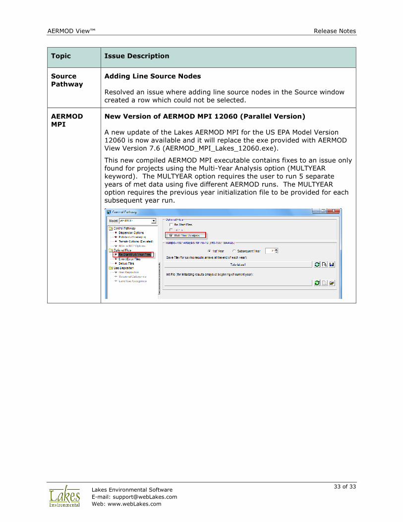
New Version of AERMOD MPI 12060 (Parallel Version)
A new update of the Lakes AERMOD MPI for the US EPA Model Version
12060 is now available and it will replace the exe provided with AERMOD
View Version 7.6 (AERMOD_MPI_Lakes_12060.exe).
This new compiled AERMOD MPI executable contains fixes to an issue only
found for projects using the Multi-Year Analysis option (MULTYEAR
keyword). The MULTYEAR option requires the user to run 5 separate
years of met data using five different AERMOD runs. The MULTYEAR
option requires the previous year initialization file to be provided for each
subsequent year run.
AERMOD View™ Release Notes
34 of 34 Lakes Environmental Software
E-mail: [email protected]
Web: www.webLakes.com
AERMOD View™ Version 8.0
Release Notes
September 5, 2012
New Features & Fixed Issues
Topic Feature Description
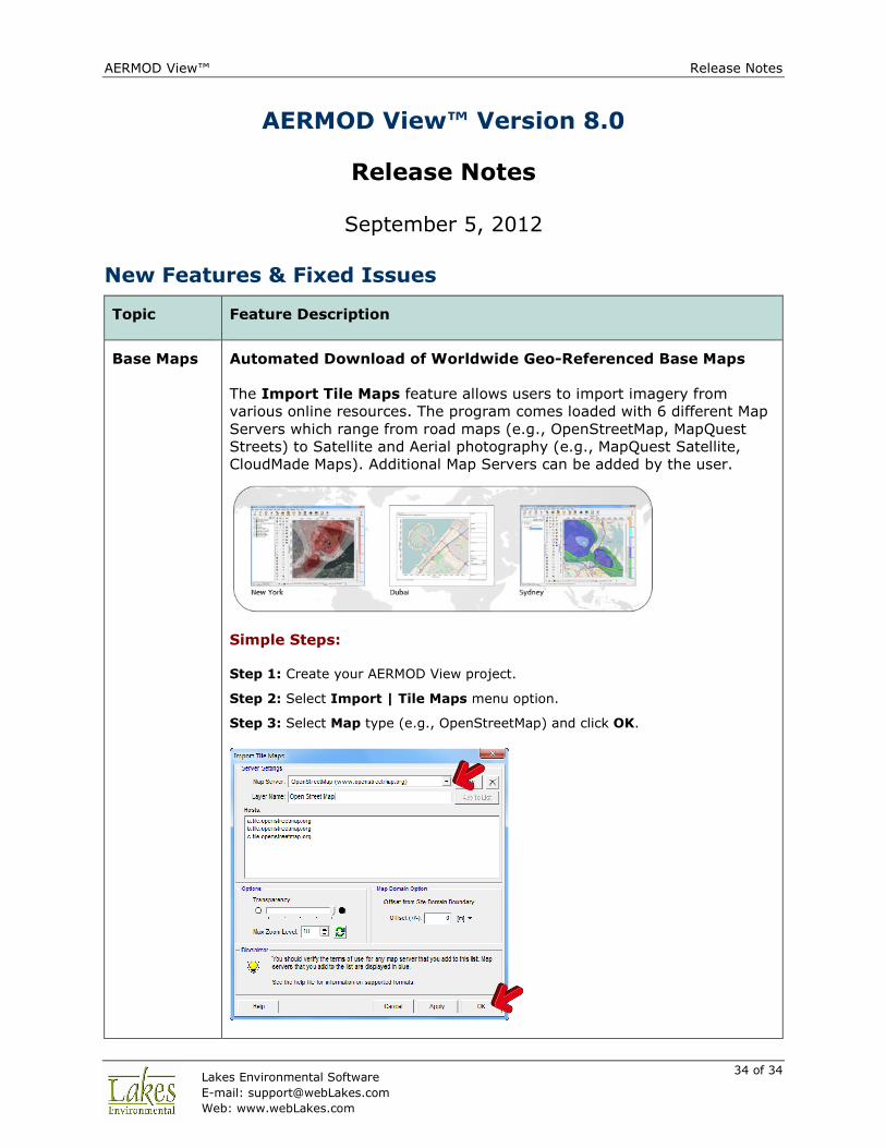
Base Maps Automated Download of Worldwide Geo-Referenced Base Maps
The Import Tile Maps feature allows users to import imagery from
various online resources. The program comes loaded with 6 different Map
Servers which range from road maps (e.g., OpenStreetMap, MapQuest
Streets) to Satellite and Aerial photography (e.g., MapQuest Satellite,
CloudMade Maps). Additional Map Servers can be added by the user.
Simple Steps:
Step 1: Create your AERMOD View project.
Step 2: Select Import | Tile Maps menu option.
Step 3: Select Map type (e.g., OpenStreetMap) and click OK.
AERMOD View™ Release Notes
35 of 35 Lakes Environmental Software
E-mail: [email protected]
Web: www.webLakes.com
Topic Feature Description
Downloaded imagery is stored locally. Check the File | Preferences |
World Map Settings to add Proxy Server details.
NOTE: The Import Tile Maps feature is only available for users with
current maintenance. If you are receiving this update as part of your
maintenance, once your maintenance expires, you will no longer have
access to this feature.
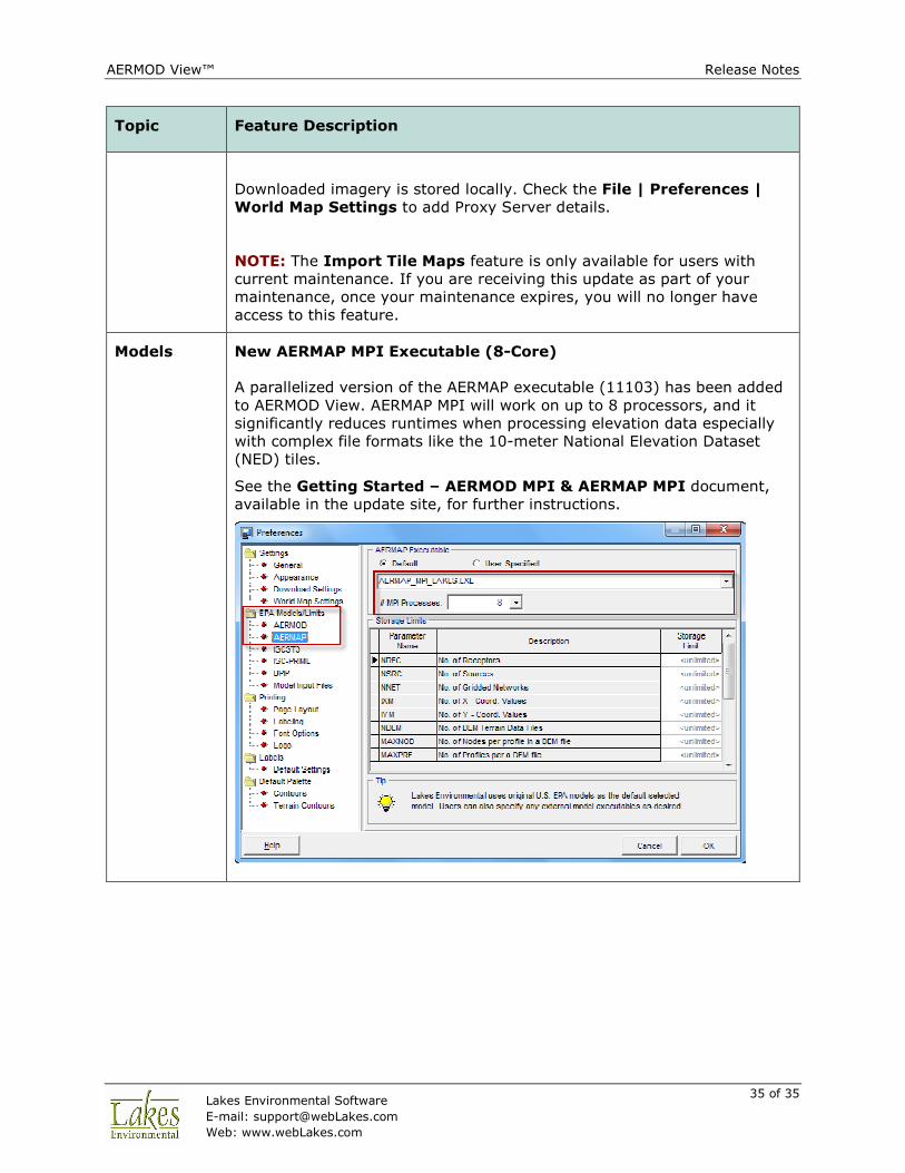
Models New AERMAP MPI Executable (8-Core)
A parallelized version of the AERMAP executable (11103) has been added
to AERMOD View. AERMAP MPI will work on up to 8 processors, and it
significantly reduces runtimes when processing elevation data especially
with complex file formats like the 10-meter National Elevation Dataset
(NED) tiles.
See the Getting Started – AERMOD MPI & AERMAP MPI document,
available in the update site, for further instructions.

AERMOD View™ Release Notes
36 of 36 Lakes Environmental Software
E-mail: [email protected]
Web: www.webLakes.com
Topic Feature Description
Import
Buildings
from DXF
Additional Options for Importing Buildings from DXF
• Layer to Import: Import more than one layer containing buildings.
• Offset Option: Allows you to shift your buildings in the project
domain (e.g. convert a local Cartesian coordinate system to UTM).
Base Maps Improved Method of Importing Multiple Georeferenced Base Maps
Using this feature allows you to search for multiple base maps, which
already contain georeferenced world files, located in the same folder and
import them either as a single layer or as separate maps.
AERMOD View™ Release Notes
37 of 37 Lakes Environmental Software
E-mail: [email protected]
Web: www.webLakes.com
Topic Feature Description
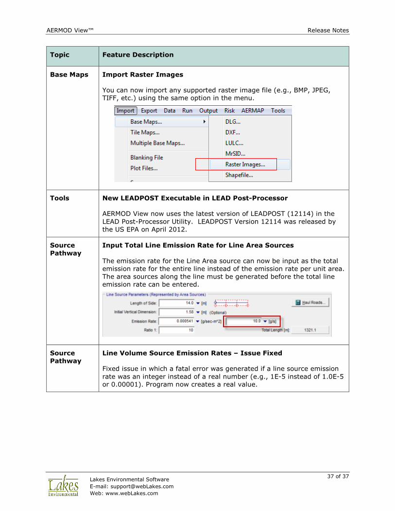
Base Maps Import Raster Images
You can now import any supported raster image file (e.g., BMP, JPEG,
TIFF, etc.) using the same option in the menu.
Tools New LEADPOST Executable in LEAD Post-Processor
AERMOD View now uses the latest version of LEADPOST (12114) in the
LEAD Post-Processor Utility. LEADPOST Version 12114 was released by
the US EPA on April 2012.
Source
Pathway
Input Total Line Emission Rate for Line Area Sources
The emission rate for the Line Area source can now be input as the total
emission rate for the entire line instead of the emission rate per unit area.
The area sources along the line must be generated before the total line
emission rate can be entered.
Source
Pathway
Line Volume Source Emission Rates – Issue Fixed
Fixed issue in which a fatal error was generated if a line source emission
rate was an integer instead of a real number (e.g., 1E-5 instead of 1.0E-5
or 0.00001). Program now creates a real value.
AERMOD View™ Release Notes
38 of 38 Lakes Environmental Software
E-mail: [email protected]
Web: www.webLakes.com
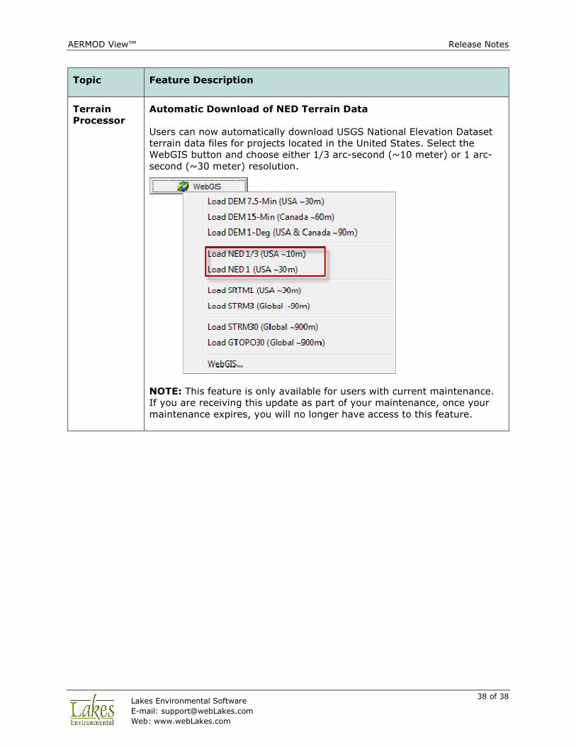
Topic Feature Description
Terrain
Processor
Automatic Download of NED Terrain Data
Users can now automatically download USGS National Elevation Dataset
terrain data files for projects located in the United States. Select the
WebGIS button and choose either 1/3 arc-second (~10 meter) or 1 arc-
second (~30 meter) resolution.
NOTE: This feature is only available for users with current maintenance.
If you are receiving this update as part of your maintenance, once your
maintenance expires, you will no longer have access to this feature.
AERMOD View™ Release Notes
39 of 39 Lakes Environmental Software
E-mail: [email protected]
Web: www.webLakes.com
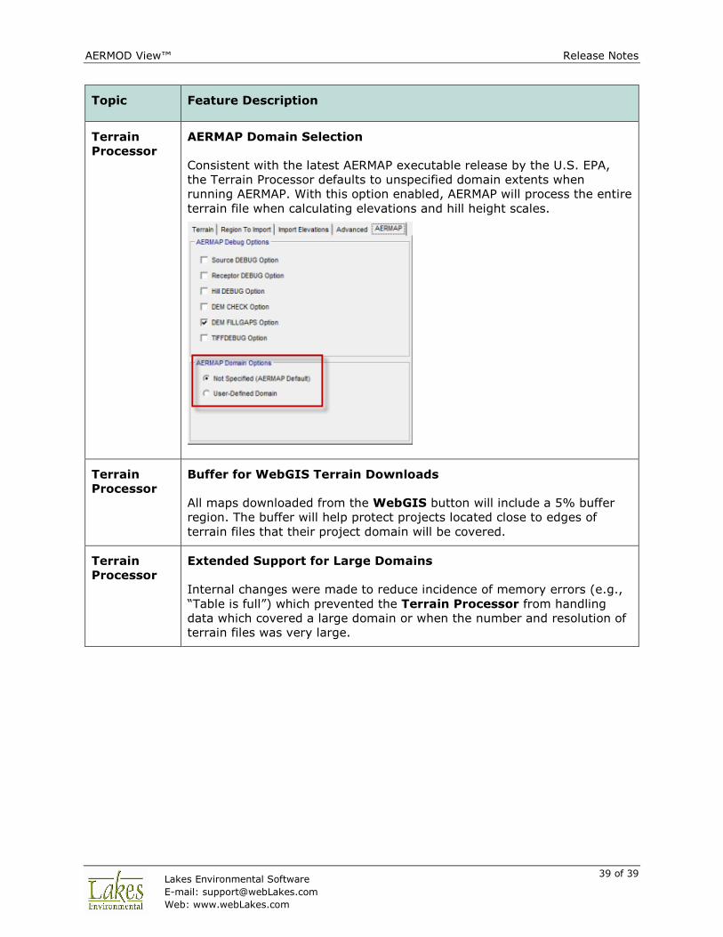
Topic Feature Description
Terrain
Processor
AERMAP Domain Selection
Consistent with the latest AERMAP executable release by the U.S. EPA,
the Terrain Processor defaults to unspecified domain extents when
running AERMAP. With this option enabled, AERMAP will process the entire
terrain file when calculating elevations and hill height scales.
Terrain
Processor
Buffer for WebGIS Terrain Downloads
All maps downloaded from the WebGIS button will include a 5% buffer
region. The buffer will help protect projects located close to edges of
terrain files that their project domain will be covered.
Terrain
Processor
Extended Support for Large Domains
Internal changes were made to reduce incidence of memory errors (e.g.,
“Table is full”) which prevented the Terrain Processor from handling
data which covered a large domain or when the number and resolution of
terrain files was very large.
AERMOD View™ Release Notes
40 of 40 Lakes Environmental Software
E-mail: [email protected]
Web: www.webLakes.com
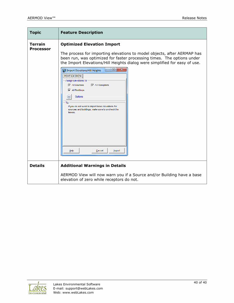
Topic Feature Description
Terrain
Processor
Optimized Elevation Import
The process for importing elevations to model objects, after AERMAP has
been run, was optimized for faster processing times. The options under
the Import Elevations/Hill Heights dialog were simplified for easy of use.
Details Additional Warnings in Details
AERMOD View will now warn you if a Source and/or Building have a base
elevation of zero while receptors do not.
AERMOD View™ Release Notes
41 of 41 Lakes Environmental Software
E-mail: [email protected]
Web: www.webLakes.com
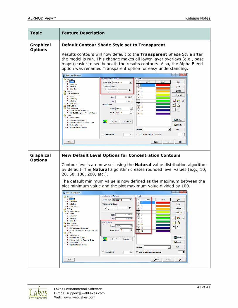
Topic Feature Description
Graphical
Options
Default Contour Shade Style set to Transparent
Results contours will now default to the Transparent Shade Style after
the model is run. This change makes all lower-layer overlays (e.g., base
maps) easier to see beneath the results contours. Also, the Alpha Blend
option was renamed Transparent option for easy understanding.
Graphical
Options
New Default Level Options for Concentration Contours
Contour levels are now set using the Natural value distribution algorithm
by default. The Natural algorithm creates rounded level values (e.g., 10,
20, 50, 100, 200, etc.).
The default minimum value is now defined as the maximum between the
plot minimum value and the plot maximum value divided by 100.
AERMOD View™ Release Notes
42 of 42 Lakes Environmental Software
E-mail: [email protected]
Web: www.webLakes.com
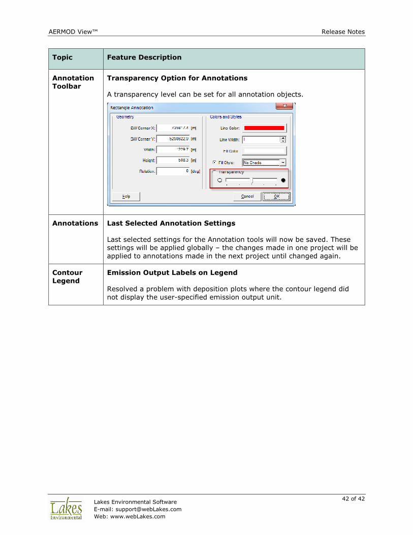
Topic Feature Description
Annotation
Toolbar
Transparency Option for Annotations
A transparency level can be set for all annotation objects.
Annotations Last Selected Annotation Settings
Last selected settings for the Annotation tools will now be saved. These
settings will be applied globally – the changes made in one project will be
applied to annotations made in the next project until changed again.
Contour
Legend
Emission Output Labels on Legend
Resolved a problem with deposition plots where the contour legend did
not display the user-specified emission output unit.
AERMOD View™ Release Notes
43 of 43 Lakes Environmental Software
E-mail: [email protected]
Web: www.webLakes.com
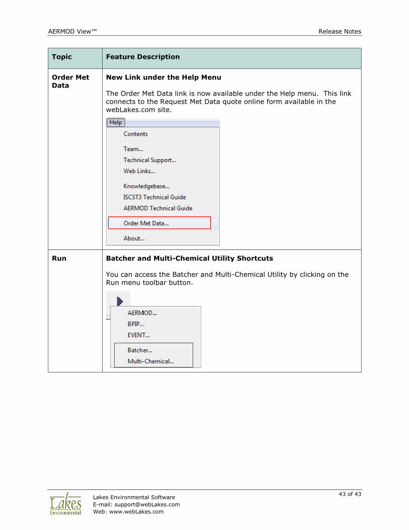
Topic Feature Description
Order Met
Data
New Link under the Help Menu
The Order Met Data link is now available under the Help menu. This link
connects to the Request Met Data quote online form available in the
webLakes.com site.
Run Batcher and Multi-Chemical Utility Shortcuts
You can access the Batcher and Multi-Chemical Utility by clicking on the
Run menu toolbar button.
AERMOD View™ Release Notes
44 of 44 Lakes Environmental Software
E-mail: [email protected]
Web: www.webLakes.com
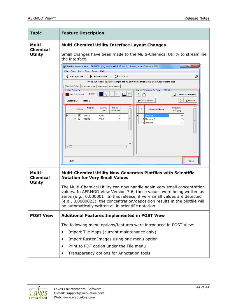
Topic Feature Description
Multi-
Chemical
Utility
Multi-Chemical Utility Interface Layout Changes
Small changes have been made to the Multi-Chemical Utility to streamline
the interface.
Multi-
Chemical
Utility
Multi-Chemical Utility Now Generates Plotfiles with Scientific
Notation for Very Small Values
The Multi-Chemical Utility can now handle again very small concentration
values. In AERMOD View Version 7.6, these values were being written as
zeros (e.g., 0.00000). In this release, if very small values are detected
(e.g., 0.0000023), the concentration/deposition results in the plotfile will
be automatically written all in scientific notation.
POST View Additional Features Implemented in POST View
The following menu options/features were introduced in POST View:
• Import Tile Maps (current maintenance only)
• Import Raster Images using one menu option
• Print to PDF option under the File menu
• Transparency options for Annotation tools