Adoption Church Fields Master Plan FINAL (Reduced)
67
Wyre Forest District Council Local Development Framework CHURCHFIELDS MASTERPLAN SUPPLEMENT ARY PLANNING DOCUMENT ADOPTED SEPTEMBER 2011 www.rewyre.org
-
Upload
racheljayne -
Category
Documents
-
view
217 -
download
0
Transcript of Adoption Church Fields Master Plan FINAL (Reduced)

8/3/2019 Adoption Church Fields Master Plan FINAL (Reduced)
http://slidepdf.com/reader/full/adoption-church-fields-master-plan-final-reduced 1/68
Wyre Forest District Council
Local Development Framework
CHURCHFIELDS MASTERPLAN
SUPPLEMENTARY PLANNING DOCUMENTADOPTED SEPTEMBER 2011

8/3/2019 Adoption Church Fields Master Plan FINAL (Reduced)
http://slidepdf.com/reader/full/adoption-church-fields-master-plan-final-reduced 2/68
Wyre Forest District Local Development Framework
Churchfields Masterplan Supplementary Planning Document
For more information contact:
Wyre Forest District Council Planning Policy Team, Worcestershire Hub, Town Hall, Vicar Street, Kidderm
T: 01562 732928
W: www.wyreforestdc.gov.uk

8/3/2019 Adoption Church Fields Master Plan FINAL (Reduced)
http://slidepdf.com/reader/full/adoption-church-fields-master-plan-final-reduced 3/68
Page 1Masterplan: Public Consultation Drat
As part o the ReWyre Initiative, Wyre Forest District Council, in Partnership with the
Homes & Communities Agency and Worcestershire County Council, teamed up with MADE
to bring together expert designers to prepare this drat Masterplan. This team includes:
This drat masterplan is also supported by:

8/3/2019 Adoption Church Fields Master Plan FINAL (Reduced)
http://slidepdf.com/reader/full/adoption-church-fields-master-plan-final-reduced 4/68
Page 2Masterplan: Public Consultation Drat
CONTENTS
i) Preace (p.3)
1) Introduction – Vision (p.6)
2) Appreciating the Context (p.10)
3) Opportunities and Constraints (p.33)
4) Consultation (p.34)5) The Strategic Framework (p.35)
6) Design Principles (p.36)
7) Character Areas (p.54)
8) The Masterplan (p.61)
9) Delivery and Implementation (p.62)
10) Funding Mechanisms (p.63)
11) Phasing (p.64)
12) Planning Applications (p.65)
13) Contacts (p.66)
LIST OF FIGURES
Fig 1: Site location plan (p.7)
Fig 2: Statutory heritage designations (p.12)
Fig 3: Heritage assets and character groups (p.14)
Fig 4: Buildings to be retained/redeveloped/reviewed (p.15)
Fig 5: Existing land uses (p.17)
Fig 6: Land ownerships (p.19)
Fig 7: Access limitations (p.21)
Fig 8: Improving connectivity (p.21)
Fig 9: Bus routes serving Churchelds and key pedestrian/cycle links (p.23)
Fig 10: Topography (p.25)
Fig 11: Stour Valley Corrdor (p.26)
Fig 12: Landscape, ecology, and open space (p.27)
Fig 13: Flood zones (p.28)
Fig 14: Gateways, edges, nodes and landmarks (p.31)Fig 15: DP1 - Connectivity (p.37)
Fig 16: Possible New vehicle links (p.39)
Fig 17: Indicative Blackwell Street Bypass (p.39)
Fig 18: New street hierarchy - including po ssible vehicle links (p.39)
Fig 19: DP2 - Open space and topography (p.41)
Fig 20: DP3 - Character areas (p.43)
Fig 21: DP4 - Frontages (p.45)
Fig 22: DP5 - New p ublic spaces (p.47)
Fig 23: DP6 - Heritage assets (p.49)
Fig 24: DP7 - High quality architecture (p.51)
Fig 25: DP8 - Vibrant communities (p.53)
Fig 26: Snapshot o character areas (p.55)
Fig 27: Churchelds Historic Quadrant (p.56)
Fig 28: Clensmore Street South (p. 57)
Fig 29: St. Mar y’s and Waterront West (p.58)
Fig 30: Churchelds North (p.59)
Fig 31: Hurcott Road (p.60)
Fig 32: Churchelds Masterplan (p.61)
Fig 33: Approximate Site Phasing Plan (p.64)

8/3/2019 Adoption Church Fields Master Plan FINAL (Reduced)
http://slidepdf.com/reader/full/adoption-church-fields-master-plan-final-reduced 5/68
Page 3Masterplan: Public Consultation Drat
PREFACE
Kidderminster Regeneration Prospectus & ReWyre Initiative
The ReWyre Initiative was launched in September 2009 withthe publication o a Regeneration Prospectus or Kidderminster.Key agencies including Wyre Forest District Council (WFDC),Worcestershire County Council (WCC), Homes & CommunitiesAgency (HCA) and British Waterways came together to make acommitment to regenerate Kidderminster through the signing o
a Memorandum o Understanding.
The Prospectus had been developed ollowing extensive publicconsultation and debate which has been well documented. Ithighlights the importance o our key ‘action areas’ which includethe Town Centre (A); Comberton Hill (B); Churchelds (C); and theormer British Sugar Site (D).
The Prospectus also highlighted our key themes that emergedstrongly in public consultation, these are: Jobs; Transport; Homesand Communities; and Design and Environmental Quality. Thesethemes will prove crucial to this Masterplan.
‘C’ is or Churchelds: Through the development o the Prospectusa new vision o Churchelds as an “urban village” o mixed housing,business and community uses emerged.
In terms o homes and communities, the ocus is clearly onthe creation o new homes and the creation o a quality urbanenvironment. Following the launch o the ReWyre Initiative,the HCA recognised Churchelds as one o a limited number o priority housing locations in the West Midlands. The aim is torecreate a residential community around a host o existing andnew community assets.
In design terms, the aim is to make the most o the area’s key built
and environmental assets which include Listed Buildings andthe Staordshire & Worcestershire Canal Conservation Area. It isalso about driving orward design quality in line with the DistrictCouncil’s Design Quality SPG with the creation o connectedlayouts and appropriate block structures. In terms o access to jobs there is emerging provision or small
scale oce and business use, community acilities and a localretail centre. Otherwise the ocus is on improving links to the towncentre and Crossley Park as major nearby employment centres.
For transport the ocus is on better connecting Churcheldsinto the wider town including new access points to the ring road,tackling the congestion and air quality problems o BlackwellStreet and providing new links across the canal and ring road toCrossley Park and the town centre respectively. It is intended thatthese new links will deliver improved public transport, walking,
and cycling accessibility.Despite being within 500 metres o the town centre, and adjacent toone o the main arterial routes into Kidderminster, the Churcheldsand Horseair area has the sense o being cut o rom the widertown. This is compounded by the act that there is currently onlyone route in and out o the area or trac.
Individual communities such as Grasmere Close are uninviting tovisitors and accessibility through the wider area is limited. It canbe threatening and opportunities or natural surveillance andsecurity are reduced through poor denition o public and privatespace.
The ‘urban village’ concept aims to create a vibrant, connected andwelcoming neighbourhood with a network o complementarycommercial and residential communities.
Birds eye view: The urban village concept illustrated in the Prospectus, Sept. 2009

8/3/2019 Adoption Church Fields Master Plan FINAL (Reduced)
http://slidepdf.com/reader/full/adoption-church-fields-master-plan-final-reduced 6/68
Page 4Masterplan: Public Consultation Drat
Role o Planning & Economic Development
Wyre Forest District Council has a key role in providing the planning
policy ramework and determining planning applications or
development in the area.
Characterised by complex browneld sites and land ownerships,
Churchelds aces multiple challenges including accessibility, airquality, and social and economic deprivation.
A range o businesses currently occupy the site. Many are on
short term tenancies and the North Worcestershire EconomicDevelopment & Regeneration Team will need to assist with any
relocation.
It is important to ensure a comprehensive approach that saeguardsagainst the piecemeal development o sites. To do otherwise would
be to risk minimising the overall package o benets that holistic
development would provide.
Statutory Development Plan
Wyre Forest District Council has a legal duty to prepare adevelopment plan or the district. The Local Development
Framework Core Strategy, adopted in December 2010, sets out
the number o homes and the amount o land or industry and
commerce to be built across the District.
The next stage in the production o the Local Development
Framework (LDF) is the creation o a more detailed development
blueprint to include policies or particular sites. The KidderminsterCentral Area Action Plan will provide the detail or Churchelds
and will allocate sites or dierent uses such as housing, business,
community uses and commercial uses such as retail and leisure.
Purpose o the Masterplan
Masterplanning is a means o exploring how an area could
develop in more detail i.e. understanding what currently exists
and outlining what could be done. It provides a more detailedand ocussed engagement and exploration exercise.
The Masterplan can perorm two main roles. Firstly, it can providean evidence base to inorm the development o the Kidderminster
Central Area Action Plan. Secondly, it can set out a detailed designramework to guide new development. In relation to the latter, a
Masterplan can guide, challenge and inorm the determination o planning applications.
Delivering the Masterplan
In 2009/10, the District Council and the HCA agreed to jointly und
the development o a masterplan in order to address the above
issues and provide a positive, proactive ramework.
In 2010, Midlands Architecture & Designed Environment (MADE)
were commissioned to undertake the masterplan on behal o the
ReWyre Initiative. The ‘client team’ includes WFDC, HCA and WCCHighways.
Bellway Homes and Asda have announced their visions through
separate pre-application consultation. These are separate and notendorsed by the masterplan under development by MADE.
Masterplan Status
The masterplan hs been ormally adopted as a Supplementary
Planning Document and as such will be a material consideration
in the determination o planning applications.

8/3/2019 Adoption Church Fields Master Plan FINAL (Reduced)
http://slidepdf.com/reader/full/adoption-church-fields-master-plan-final-reduced 7/68
Page 5Masterplan: Public Consultation Drat
Structure
The structure o the masterplan is as ollows:
1. Introduction: background to the area and the masterplan.
2. Appreciating the physical, social and economic context:
summarises the analysis o the site, surroundings and planningpolicy.
3. Opportunities and constraints: identies the area’s key
opportunities and constraints, based on the ndings o section 2.
4. Consultation: details the process o engaging with the public
and statutory consultees.
5. Strategic ramework: establishes design principles and urban
structure or the area.
6. Detailing the Place: Character areas will be dened in order toestablish more detailed design principles on individual sites.
7. Delivery and implementation: will consider issues o phasing,and requirements or applying or planning permission.
8. Contacts: lists the important contacts associated with this
project.

8/3/2019 Adoption Church Fields Master Plan FINAL (Reduced)
http://slidepdf.com/reader/full/adoption-church-fields-master-plan-final-reduced 8/68
Page 6Masterplan: Public Consultation Drat
1. INTRODUCTION
Background
This masterplan has been prepared by MADE on behal o the
ReWyre Board and Wyre Forest District Council. The document
hass been adopted as a Supplementary Planning Document (SPD)providing design policies and guidance or the regeneration o the
area.
The masterplan has been developed ollowing several periods o public consultation. Two public consultation weekends were held
in November 2010 and February 2011. These explored the rationale
or the masterplan, site area and overall vision. The drat masterplan
was prepared having ull regard to the ndings o this engagementwith the local community. The ndings o the consultation are
highlighted within the relevant sections o the plan. A consultation
period on the drat masterplan was held over six weeks between
May and July 2011 jointly with the consultations on the preerred
options stage Kidderminster Central Area Action Plan and SiteAllocations & Policies Development Plan Documents.
The masterplan area (see gure 1) is located to the north o
Kidderminster Town Centre. It has been highlighted as an
important housing-led mixed use regeneration site. Following
consultation the site boundary was extended to include St George’sPark and adjacent land at Crossley Park with the area now covering
more than 30 ha.
The Churchelds area is accessed rom a single point at the junctiono Broad Street, Stourbridge Road, Blackwell Street and Radord
Avenue. This is a congestion hotspot and suers rom poor air
quality and is a designated Air Quality Management Area (AQMA).
Public transport in the area is poor and limited to the A451. Thedisconnected road network means that it is dicult o public
transport to penetrate the area. Walking and cycling links to the
town centre are indirect and unwelcoming.Outputs
A masterplanning process should lead to:
The creation o a three dimensional plan which presents proposals
or aspirations or the development o:
- buildings
- street blocks- public spaces
- streets
- landscape
- approaches to parking and servicing
The masterplan does not go as ar as designing buildings.
The spatial masterplan is expressed in diagrams, land use plans,models and explanatory images as well as in words.
It needs to be supported by the data gathered during preparation
and demonstrate how it relates to the implementation strategy.
8/3/2019 Adoption Church Fields Master Plan FINAL (Reduced)
http://slidepdf.com/reader/full/adoption-church-fields-master-plan-final-reduced 9/68
Page 7Masterplan: Public Consultation Drat
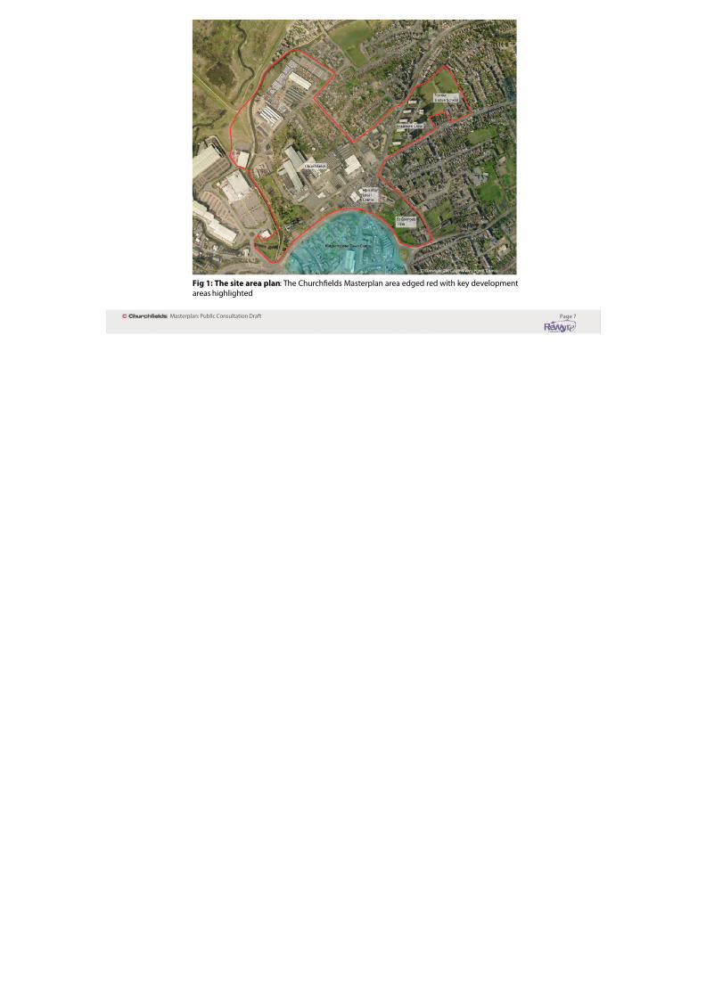
Fig 1: The site area plan: The Churchelds Masterplan area edged red with key development
areas highlighted

8/3/2019 Adoption Church Fields Master Plan FINAL (Reduced)
http://slidepdf.com/reader/full/adoption-church-fields-master-plan-final-reduced 10/68
Page 8Masterplan: Public Consultation Drat
AIMS - The Masterplan must be:
Visionary - Raise aspirations and provide a vehicle or consensus
building and implementation.
Deliverable - take account o implementation and delivery routes
and integrate with the land use planning system, yet challenge it.
Flexible - provide the basis or negotiation and dispute resolution
and be adaptive to changing circumstances.
Participatory - provide stakeholders the opportunity to ullyengage.
It should aim to rethink existing neighbourhoods and create new
ones.
OBJECTIVES
The masterplan sets out planning and design principles andaims to enable a coherent and inormed approach to the uture
masterplanning o the area in order to ensure high quality design.
The masterplan will:
• Ensure development is based on a sound understanding of local
character and circumstances, especially given the historic contextset by the canal conservation area and nearby Listed Buildings and
historic churches.
• Establish the relevant planning and design policies that willinfuence and shape the orm o development.
• Establish key principles to guide sustainable development.
• Give certainty to interested developers and investors aboutthe expectations o the local planning authority and wider
community.
• Make provision for the delivery and phasing of development.
SPECIFIC OBJECTIVES include:
1) Show how streets, squares and open spaces are to be
connected.
2) Dene the height, bulk and massing o buildings.
3) Suggest relationships between buildings and public spaces.
4) Determine the activities and land uses to take place in thearea.*
5) Identiy movement patterns or people on oot, or by bicycle,
car or public transport, as well as looking at the needs o serviceand reuse vehicles.
6) Relate to the physical orm o the site to social, economic andcultural contexts and take account o needs o people living and
working in the area.
7) Show ways in which new neighbourhoods can be incorporatedinto existing communities, as well as built and natural
environments.
* The Masterplan suggests activities. However, these aspects o the plan will
need to be ratied through the Kidderminster Central Area Action Plan as theormal Development Plan Document. In the m eantime, in all other respects,
the Masterplan provides appropriate design guidance that is capable o
being adopted as ormal planning policy in the orm o a Supplementary
Planning Document.

8/3/2019 Adoption Church Fields Master Plan FINAL (Reduced)
http://slidepdf.com/reader/full/adoption-church-fields-master-plan-final-reduced 11/68
Page 9Masterplan: Public Consultation Drat
VISION FOR CHURCHFIELDS:
“Churchfelds in Kidderminster should be redeveloped in a way that embraces
its existing character and that o the surrounding context and delivers a
sustainable urban village o quality, which creates a unique sense o place.”

8/3/2019 Adoption Church Fields Master Plan FINAL (Reduced)
http://slidepdf.com/reader/full/adoption-church-fields-master-plan-final-reduced 12/68
Page 10Masterplan: Public Consultation Drat
2) APPRECIATING THE CONTEXT
Area description
The area is an eclectic mix o housing, industry, warehousing,
oces, retail, open spaces, car sales and community uses but the
individual elements are disconnected and serve to create poor
relationships creating an uninviting environment.
It has been subject to several periods o insensitivecomprehensive redevelopment. To the west this involved
replacing historic communities to make way or large actories
and in the east the creation o 1960s high rise homes at Grasmere
Close.
The nal act was the creation o the town centre ring road inthe 1960s/ 70s which tore through the area. This severed the
neighbourhood rom the town centre. St Mary’s Street was closed
to concentrate trac on Blackwell Street, and the important link
rom St Mary ’s Church to the town centre via Church Street wassevered. Blackwell Street itsel, one o the main arterial routes o
the town, was cut in two by the ring road.
Whilst there are a number o very strong heritage assets
including the canal conservation area and Listed Buildings, suchas the Grade 1* Listed St Mary’s Church, you have to search them
out as the area currently turns its back on its key assets. Despite
being highly visible rom the ring road, St Mary’s Church lacks a
sense o place that belies its medieval origins.
The area benets rom changes in levels which oer distant viewsand increases the prominence o landmarks in their setting,
whilst oering the opportunity to impact positively on the
landscape through sensitively designed development atop theridges o the Stour valley.
The River Stour and Staordshire & Worcestershire Canal oer astrong linear landscape infuence, with the Stour having a wider
impact through the dening topography o the valley sides. From
the wetlands o the Puxton Marsh SSSI in the west the land rises
towards the east o the area through a series o marked ridges.
Despite a rich and varied landscape, the character o the areais strongly infuenced by social, economic and environmental
deprivation. The majority o the area alls within one o the mostdeprived wards o Worcestershire and Broad Street is recognised
as one o the ‘Areas o Highest Need’.
The ollowing sections explore individual elements o the area’scontext in more detail, these are:
Historic•
Land Use•
Land Ownership•
Movement and Access• Topography•
Landscape, Ecology, and Open Space•Gateways, Edges, Nodes, and Landmarks•

8/3/2019 Adoption Church Fields Master Plan FINAL (Reduced)
http://slidepdf.com/reader/full/adoption-church-fields-master-plan-final-reduced 13/68
Page 11Masterplan: Public Consultation Drat
Historic context
Churchelds in context:1880s
The medieval St Mary’s Church sits in a prominent positionand was the centre o a community around Dudley Street,
Churchelds and Duke Street (now the public meeting rooms to
Duke House). St Mary’s school used to be located adjacent to thechurch beore moving to Stoney Lane around the 1970s.
The grain o development was ne with terraced streetsrefecting the topography running north south radiating rom
Dudley Street. This street (now cut o by CMS Vauxhall dealership
and Kwik Fit) was a key street connecting to Church Street andthe town centre. The only trace o the street now is a short spur
o Blackwell Street in the Horseair.
The junction o Dudley Street and Blackwell Street continues
to have a strong sense o enclosure and space. The place is
ramed by landmarks such as the Old Peacock PH and threestorey Georgian properties which bet the site’s heritage as an
important junction. A number o the critical landmark buildings
that ramed this sense o place remain throughout the area.
This is illustrated a little urther north rom Dudley Street at theHorseair which historic mapping indicates was one o the most
signicant public spaces in the town. Presumably this refects itshistoric signicance as a place where horses were once traded.
Elsewhere, the larger buildings associated with industry tended
to straddle the River Stour and the Staordshire & Worcestershire
Canal. This made sense as part o a legible landscape where
industry needed the resources o the River Stour and the canal ortransport.
Churchelds in context: 2010
The above plan illustrates how the area’s ne grain and legibility
has been lost. The Tomkinson Carpet actory o Churcheldswas the only major carpet actory located outside the River Stour
valley bottom.
The ollowing images and plans illustrate the heritage assets
within the area with a photo montage identiying examples o how important heritage buildings can be reurbished and used in
a productive manner, whilst still protecting their historic abric.

8/3/2019 Adoption Church Fields Master Plan FINAL (Reduced)
http://slidepdf.com/reader/full/adoption-church-fields-master-plan-final-reduced 14/68
Page 12Masterplan: Public Consultation Drat
Fig 2: Statutory Heritage Designations

8/3/2019 Adoption Church Fields Master Plan FINAL (Reduced)
http://slidepdf.com/reader/full/adoption-church-fields-master-plan-final-reduced 15/68
Page 13Masterplan: Public Consultation Drat
G r e e n
S t r e e t , K i d d e r m i n
s t e r - p r e c e d e n t f
o r c o n v e r s i o n
8/3/2019 Adoption Church Fields Master Plan FINAL (Reduced)
http://slidepdf.com/reader/full/adoption-church-fields-master-plan-final-reduced 16/68
Page 14Masterplan: Public Consultation Drat
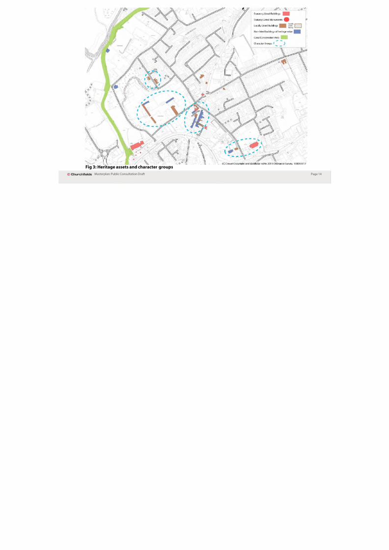
Fig 3: Heritage assets and character groups

8/3/2019 Adoption Church Fields Master Plan FINAL (Reduced)
http://slidepdf.com/reader/full/adoption-church-fields-master-plan-final-reduced 17/68
Page 15Masterplan: Public Consultation Drat
Fig 4: Buildings to be retained/redeveloped/reviewed

8/3/2019 Adoption Church Fields Master Plan FINAL (Reduced)
http://slidepdf.com/reader/full/adoption-church-fields-master-plan-final-reduced 18/68
Page 16Masterplan: Public Consultation Drat
Land Use
The Churchelds area is ocussed on a designated local centre o
specialist and convenience retailing along Blackwell Street and
at Horseair. To the west is an extensive area o historic industry
in the orm o two ormer carpet actories now sub-divided andin temporary uses. Other small scale workshops and business
premises exist in this area.
There are extensive car sales which ront onto the ring roadand back onto Churchelds. This creates a very industrial edge
to Churchelds and the access to the two prominent churcheso St Mary ’s and Trinity. The east o the area is characterised by
suburban residential and 1960s high rise developments.
There is also a signicant ormal park at St George’s and a number
o dening open spaces on the edge o the neighbourhoods. To
the west this is dened by the linear corridor o the canal andriver and to the east by St George’s churchyard and park and
Baxter Gardens.
To the north and east the adjoining character is residential
with some business premises interspersed. To the north west is
Puxton Marsh SSSI and to the west is Crossley Park including anextensive retail park. To the south beyond the ring road is the
town centre which is approximately a 10 minute walk.
The area’s position on the north west acing slopes o the valley
side oers distant views over the valley to wooded escarpments
and elds beyond.

8/3/2019 Adoption Church Fields Master Plan FINAL (Reduced)
http://slidepdf.com/reader/full/adoption-church-fields-master-plan-final-reduced 19/68
Page 17Masterplan: Public Consultation Drat
Fig 5: Existing land uses
8/3/2019 Adoption Church Fields Master Plan FINAL (Reduced)
http://slidepdf.com/reader/full/adoption-church-fields-master-plan-final-reduced 20/68
Page 18Masterplan: Public Consultation Drat
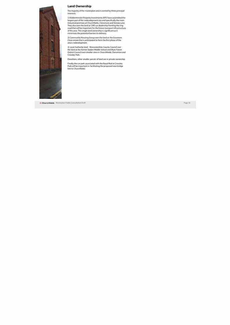
Land Ownership
The majority o the masterplan area is owned by three principal
interests:
1) Kidderminster Property Investments (KPI) have assembled the
largest part o the redevelopment site and specically the main
industrial premises at Churchelds, Clensmore and Stoney Lane. They also own the land at CMS car dealership ronting the ring
road that will be important or the uture transport inrastructureo the area. This single land ownership is signicant as it
minimises the potential barriers to delivery.
2) Community Housing Group own the land at the GrasmereClose estate that is anticipated to orm the rst phase o the
area’s redevelopment.
3) Local Authority land - Worcestershire County Council own
the land at the ormer Sladen Middle School and Wyre Forest
District Council own smaller sites in Churchelds, Clensmore andCrossley Park.
Elsewhere, other smaller parcels o land are in private ownership.
Finally, the car park associated with the Royal Mail at Crossley
Park will be important in acilitating the proposed new bridge
link to Churchelds.

8/3/2019 Adoption Church Fields Master Plan FINAL (Reduced)
http://slidepdf.com/reader/full/adoption-church-fields-master-plan-final-reduced 21/68
Page 19Masterplan: Public Consultation Drat
Fig 6: Land ownerships

8/3/2019 Adoption Church Fields Master Plan FINAL (Reduced)
http://slidepdf.com/reader/full/adoption-church-fields-master-plan-final-reduced 22/68
Page 20Masterplan: Public Consultation Drat
Movement and Access
Highway Network
The Churchelds area has a number o movement and access
issues. The area is accessed rom the ring road by one main
arterial route (Blackwell Street), which is oten congested and is
identied as an AQMA. Through the masterplan, opportunitiesexist to explore the provision o new access points to allow a
choice o movement to and rom the masterplan area by a variety
o travel modes.
The Churchelds area is bordered to the south by the St Mary’sRingway section o the A456 Kidderminster Ring Road. This
engineered dual carriageway orms the principal route through
Kidderminster and around the town centre, and this sectioncarries some 20,000 vehicles per day. There is congestion at peak
periods at the roundabout junction with Blackwell Street and the
trac signals at Carpet Trades Way.
To the east o the area is the A451 Blackwell Street/StourbridgeRoad which carries some 10,000 vehicles per day and orms one
o the main radial routes o the town, leading to Stourbridge and
the Black Country. Blackwell Street is narrow with inadequateootways and is a designated AQMA, due to the high levels o
nitrogen dioxide. This is a consequence o the relatively high
volumes o trac, the narrow space between the buildings and
trac congestion at the junctions with the ring road and theHorseair.
Blackwell Street/Stourbridge Road joins Broad Street,
Churchelds and Radord Avenue at the triangular space o the Horseair, with Radord Avenue orming a link to the next
radial route to the east, the A456 Birmingham Road. The Radord
Avenue/Stourbridge Road/Blackwell Street junction is controlledby trac signals with pedestrian acilities.
Although only the eastern side o the Horseair is busy, the two-way routes around the space and the parking in the centre mean
that there is little room let over or non-highway unctions,
although a public art scheme is planned or the site.
Improving the access, movement and permeability o the
whole masterplan area is one o the key themes o the SPD.
Development will need to open up the access to the site andallow better connections to, and within, the area. Options to
enable this to happen (such as linking over to Crossley RetailPark and providing a new access point rom the ring road) are
discussed later in the document.*
Wyre Forest District Council will continue to work closely with
Worcestershire County Council and developers to identiy
options or improving access to the Churchelds and Horseairarea or motorised modes rom adjacent areas.
* The Churchelds masterplan is a design ramework to guide the uturedevelopment o the area. The specic transport proposals present in this
document are ambitions or the area and have been developed using
specialist transport advice. However, at this stage they are indicative and havenot been ully tested. Specic proposals will need to supported by technical
evidence to show their impacts on the wider trafc network.

8/3/2019 Adoption Church Fields Master Plan FINAL (Reduced)
http://slidepdf.com/reader/full/adoption-church-fields-master-plan-final-reduced 23/68
Page 21Masterplan: Public Consultation Drat
Fig 7: Limited access opportunities leads to congestionFig 8: Improving connectivity through the area

8/3/2019 Adoption Church Fields Master Plan FINAL (Reduced)
http://slidepdf.com/reader/full/adoption-church-fields-master-plan-final-reduced 24/68
Page 22Masterplan: Public Consultation Drat
Movement and Access
Pedestrian, Cycle, and Public Transport
Within the masterplan area itsel, the low levels o trac mean
that walking and cycling conditions are reasonable, except on
Blackwell Street, and there are ootways along all o the routes.
Although there are some personal security issues, particularlyater dark, the canal towpath orms a reasonably attractive route
into to the town.
Crossing or negotiating the routes that border the area is moredicult, however. The ring road orms a substantial barrier
between Churchelds and the town centre, with crossing
only being possible at the underpasses at the Blackwell Streetroundabout and near St Mary’s Church, and via the towpath o
the canal that passes beneath the trac signal junction with
Carpet Trades Way. All o these routes are highly unwelcoming to
pedestrians.
Routes across the canal are limited to Lime Kiln Bridge, at the lock near to the ring road and via the Waterside Grange estate to the
north. None o these routes are particularly welcoming.
Stourbridge Road and Blackwell Street are less o a barrier to
movement, although ormal crossing opportunities are limited
to a pelican crossing near the Hurcott Road fats and pedestrianacilities at the signalised junction o Blackwell Street and
Radord Avenue.
Footways along Blackwell Street are narrow and the heavy
trac makes this an unpleasant place to walk through, althoughpedestrian volumes are high as this is a key route into the town
centre or much o north Kidderminster.
There are no dedicated cycling acilities within the masterplan
area, although the canal towpath is designated as part o the
National Cycle Network. There is also a pleasant trac-ree routeleading to the Marlpool Estate via the food deence bund across
the Stour valley.
Public transport in the masterplan area is limited to the 30minute requency No.9 bus route along Stourbridge Road/
Blackwell Street, which extends to Caunsell/Cookley. There is
also the twice daily No.580 service along Hurcott Road/BlackwellStreet to Kinver. When the Crossley Retail Park site was opened
a bus service was unded by the developer, linking the site withthe town centre via Carpet Trades Way, but this did not prove to
be viable once the initial subsidy had ended, due to the limitedpatronage and the congestion at the ring road junction.
All o the local bus services terminate in the town centre to the
south o the masterplan area but, as noted above, the walkinglinks to the town centre are poor.

8/3/2019 Adoption Church Fields Master Plan FINAL (Reduced)
http://slidepdf.com/reader/full/adoption-church-fields-master-plan-final-reduced 25/68
Page 23Masterplan: Public Consultation Drat
Fig 9: Bus routes serving Churchfelds and key pedestrian/cycle links

8/3/2019 Adoption Church Fields Master Plan FINAL (Reduced)
http://slidepdf.com/reader/full/adoption-church-fields-master-plan-final-reduced 26/68
Page 24Masterplan: Public Consultation Drat
Topography The area is strongly infuenced by the River Stour Valley, with
quite a dramatic change in levels rom the higher ground in
the east to the river bed in the west There are a series o three
plateaus within the area with two ridges running through thearea marking the separation between these areas. Sandstone
ridges are a characteristic o the town’s underlying geology,
although within the landscape o Churchelds, they are
characterised by sot vegetation or retaining walls.

8/3/2019 Adoption Church Fields Master Plan FINAL (Reduced)
http://slidepdf.com/reader/full/adoption-church-fields-master-plan-final-reduced 27/68
Page 25Masterplan: Public Consultation Drat
Fig 10: Topography
8/3/2019 Adoption Church Fields Master Plan FINAL (Reduced)
http://slidepdf.com/reader/full/adoption-church-fields-master-plan-final-reduced 28/68
Page 26Masterplan: Public Consultation Drat
Landscape, Ecology and Open Space
To the north west o the area, the sites are strongly infuenced by
the Puxton Marsh SSSI. The area benets rom distant views o the
surrounding rolling Worcestershire countryside.
Suburban housing areas are characterised by mature trees within
private gardens and the street scene. However, the majority o the
opportunity sites are extensive ormer carpet actory premises that
are largely devoid o vegetation on the interior except or sot edges
on the periphery o the sites i.e. either to the canal (the ormerGeorgian Carpets actory) and the ridge running to the west and
north o the ormer Tomkinsons actory.
The area includes the ormal St George’s Park with a strong
community ocus through the ‘Friends o St George’s Park’ group.
There are also two major church cemeteries at St George’s and the
medieval St Mary’s Church.
The Staordshire & Worcestershire Canal has a heavily vegetated
green edge which almost gives it a semi-rural eel that belies its
urban setting. This is more the result o neglect than design with
much development turning its back on the canal. As a result there arelow levels o natural surveillance and a high incidence o anti-social
behaviour.
The area is well served by a range o strategic open spaces around its
edge. These provide community, sport and recreation opportunities
or residents. They include St George’s Park (within the masterplan
area),
Springeld Park
to the north
and Baxter
Gardens to
the east o themaster plan
area.
There are
opportunities
to enhance
provision or play and recreation within the interior o the masterplan
area. In addition, signicant o-site improvements may be sought
or playing elds at Springeld Park and Sion Hill as a means o
improving acilities serving the community. These opportunities will
be explored and developed as part o the plan making process.
Biodiversity
The many green corridors and open spaces in the Churchelds area
provide good opportunities to preserve and enhance biodiversity.
The areas position withinin the Stour Valley Corridor urther
underlines the importance o preserving these links through the site
and beyond.
The canal is an important green corridor that runs close to, and in
parallel with, the river Stour. However, it must be recognised that the
canal traditionally had an urban/industrial heritage and environment
and the lack o built development now apparent leads to issues o
anti-social behaviour. It will be important to consider the biodiversity
habitat o the canal side areas in the ace o new development.
However, this must be careully balanced with the need to provide an
active rontage and natural surveillance on to the canal.
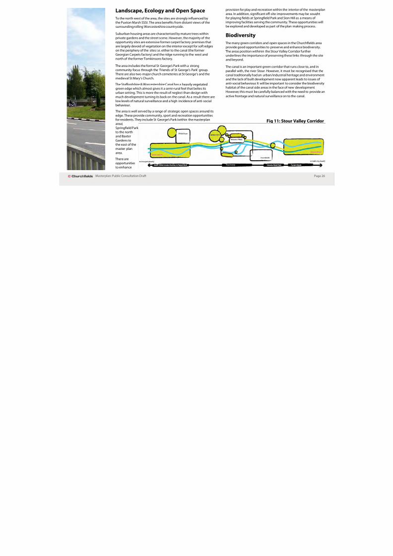
Fig 11: Stour Valley Corridor

8/3/2019 Adoption Church Fields Master Plan FINAL (Reduced)
http://slidepdf.com/reader/full/adoption-church-fields-master-plan-final-reduced 29/68
Page 27Masterplan: Public Consultation Drat
Poorly dened spaces Consider relocating Mature trees and green space refect the edge o the ormer Tomkinson actory and create a link
through the area.
Fig 12: Landscape, ecology, and open space
8/3/2019 Adoption Church Fields Master Plan FINAL (Reduced)
http://slidepdf.com/reader/full/adoption-church-fields-master-plan-final-reduced 30/68
Page 28Masterplan: Public Consultation Drat
Water Management & Flood Risk
Most o the Churchelds masterplan area alls outside o the River
Stour foodplain. However, a small area o land west o the canal
at Crossley Retail Park alls within Flood Zone 3 and a small edge
adjacent to the canal o the Churchelds North site is within Flood
Zone 2.
A Strategic Flood Risk Assessment was undertaken as part o the
evidence base or the Local Development Framework and the
adopted Core Strategy contains policies on Water Management.Policy CP02: Water Management states that appropriate mitigation
and construction methods will be required or development in
areas with known surace water fooding issues. It also states
that Sustainable Urban Drainage Systems (SUDS) will need to
be incorporated within new developments and they should be
inormed by the Water Cycle Strategy.
The emerging Site Allocations & Policies Document also contains a
section on water management, food risk, and SUDS.
New developments in the Churchelds area will need to take into
account the ollowing advice in regards to water management:
PPS25: Development and Flood Risk •
Strategic Flood Risk Assessment•
Water Cycle Strategy•
Water Framework Directive•
River Severn River Basin Management Plan•
All new development in food risk areas will be expected to producea food risk assessment as part o any planning application in line
with the advice in PPS25.
Ground Water & Contamination
The Churchelds area overlies a principal aquier o regional
strategic importance and alls within the Source Protection Zone
3 o a public water supply borehole. Thereore, this area is within a
hydrologically sensitive setting.
As Churchelds has been a signicant industrial area or over
100 years, there are likely to be issues o contamination. New
development will need to ensure that contamination is ully
addressed and appropriate remediation measures are taken topreserve this senstive area.
This is in line with adopted Core Strategy policy CP01: Delivering
Sustainable Development Standards.

8/3/2019 Adoption Church Fields Master Plan FINAL (Reduced)
http://slidepdf.com/reader/full/adoption-church-fields-master-plan-final-reduced 31/68
Page 29Masterplan: Public Consultation Drat
Fig 13: Flood zones

8/3/2019 Adoption Church Fields Master Plan FINAL (Reduced)
http://slidepdf.com/reader/full/adoption-church-fields-master-plan-final-reduced 32/68

8/3/2019 Adoption Church Fields Master Plan FINAL (Reduced)
http://slidepdf.com/reader/full/adoption-church-fields-master-plan-final-reduced 33/68
Page 31Masterplan: Public Consultation Drat
Fig 14: Edges, rontages and key landmarks

8/3/2019 Adoption Church Fields Master Plan FINAL (Reduced)
http://slidepdf.com/reader/full/adoption-church-fields-master-plan-final-reduced 34/68
Page 32Masterplan: Public Consultation Drat
Planning Policy
Wyre Forest District Local Development Framework continues to
be developed. The Core Strategy was adopted in December 2010
and this sets the strategic ramework or development including
the overall quantum o housing, industry and commercialdevelopment that needs to be provided or within the District to
2026. This drat masterplan has been prepared having ull regard
to the provisions o the Core Strategy and the Wyre Forest District
Design Quality SPG.
8/3/2019 Adoption Church Fields Master Plan FINAL (Reduced)
http://slidepdf.com/reader/full/adoption-church-fields-master-plan-final-reduced 35/68
Page 33Masterplan: Public Consultation Drat
3) OPPORTUNITIES AND CONSTRAINTS
Constraints
The top ve constraints are:
i) Access, trac and parking - barriers to movement.
ii) Environmental quality.
iii) Out-o-centre location limits land use options.
iv) Land ownership.
v) Delivery issues.
Turning ‘Challenges’ into ‘Opportunities’
The top ve key opportunities are:
i) Improve links to the Town Centre and Crossley Park.
ii) Create a series o connected spaces and squares.
iii) Support and strengthen the town centre.
iv) Improve trac capacity at Blackwell Street.
v) Incorporate heritage assets - canal and buildings.
vi) Ensure development orm respects topography.
Improving access to jobs in nearby retail and service centres is akey ambition o the masterplan. The plan serves to support and
strengthen the town centre by creating additional homes and
residents to provide additional vitality and spending capacity in
the centre. At the same time it will also serve to do the same orthe complementary ‘local centre’ o Blackwell Street/Horseair as
a small-scale retail environment serving the local needs o the
Churchelds neighbourhood and specialist shopping.
CHALLENGES
INTO
OPPORTUNITIES

8/3/2019 Adoption Church Fields Master Plan FINAL (Reduced)
http://slidepdf.com/reader/full/adoption-church-fields-master-plan-final-reduced 36/68
Page 34Masterplan: Public Consultation Drat
4) COMMUNITY CONSULTATION
Extensive consultation on the Kidderminster Prospectuswas undertaken during 2008/09 that established the idea o
Churchelds as an urban village and ocus or new homes.
This masterplan has involved two urther periods o public
consultation including a series o workshops and two roadshow
events.
Phase 1: Issues and Options Consultation, took place in
November 2010 with a special ‘pop up shop’ in Blackwell Street.
Phase 2: Concepts and Ideas Consultation was held at the
Salvation Army, Jerusalem Walk in February 2011, at which initial
concepts were presented to the local community. Over thecourse o the two events the consultation team met over 250
people.
There has been continuous engagement with public and private
sector stakeholders, including local councillors, proessional
ocers, and the business community.
The consultation events provided some excellent and productive
eedback that has been pivotal in the development o the plan
or the area. The top 5 issues highlighted by the local community
were:
1. Improve connections to the town centre and around the
area.
2. Regenerate the Horseair and improve the retail area.
3. Solve trac and congestion issues.
4. Provide new homes to replace industry.
5. Improve community acilities.
A separate consultation report is available as an Appendix to thisreport.
Drat Masterplan Consultation
A six week consultation period on the drat masterplan took
place between May and July 2011. Written notications were
sent to stakeholders and statutory bodies and adverts were takenout in the local press. Staed exhibitions were also held at the,
Kidderminster market, the Rowland Hill Centre, Kidderminster,the ormer Lloyds Garage, Stourport, and Bewdley Museum,Bewdley.
A total o 103 responses were received rom 47 respondents.All o the comments were taken into account by the District
Council when producing the nal version o the masterplan. An
individual response to each comment was also supplied.
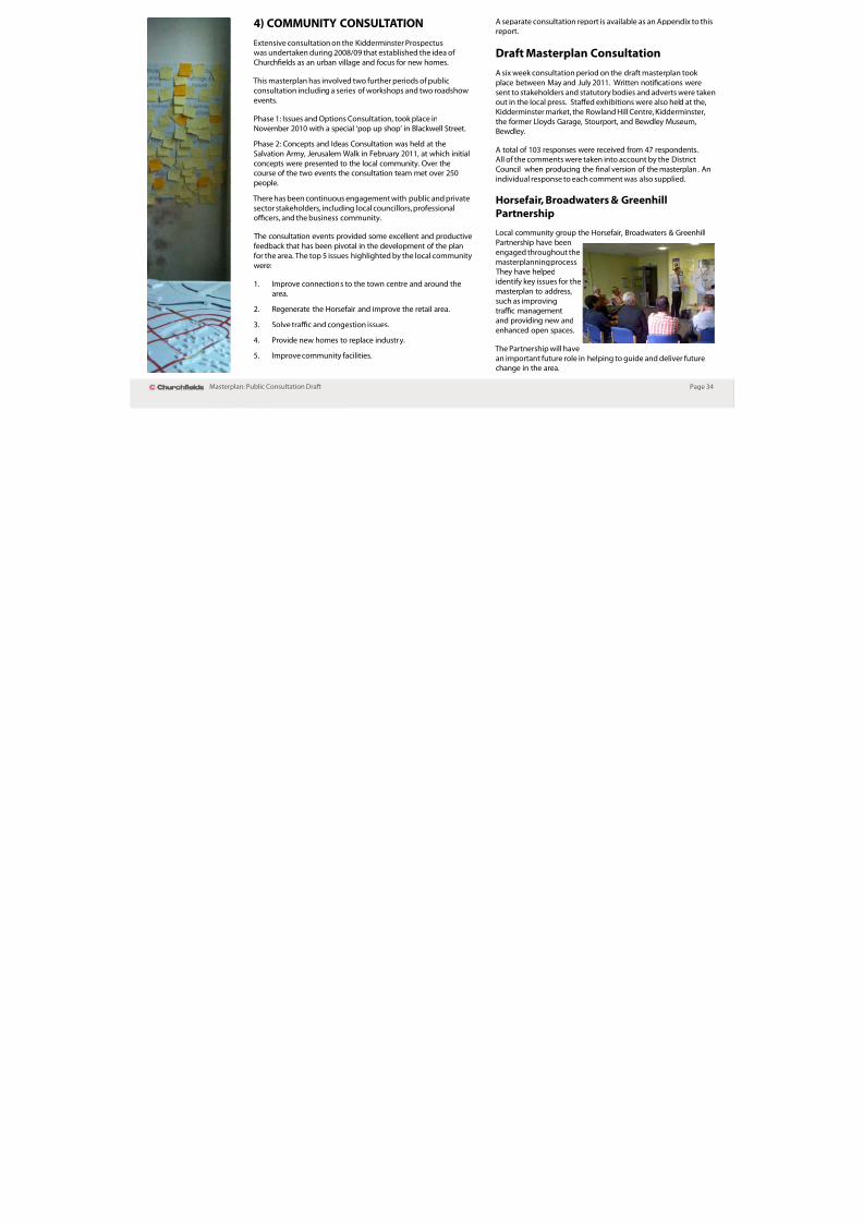
Horseair, Broadwaters & Greenhill
PartnershipLocal community group the Horseair, Broadwaters & Greenhill
Partnership have been
engaged throughout the
masterplanning process. They have helped
identiy key issues or the
masterplan to address,
such as improvingtrac management
and providing new andenhanced open spaces.
The Partnership will have
an important uture role in helping to guide and deliver uturechange in the area.

8/3/2019 Adoption Church Fields Master Plan FINAL (Reduced)
http://slidepdf.com/reader/full/adoption-church-fields-master-plan-final-reduced 37/68
Page 35Masterplan: Public Consultation Drat
5) THE STRATEGIC FRAMEWORK
The design guidance or the Churchelds area is set out belowand is based on the key urban design objectives and development
principles as set out in the Wyre Forest District Design Quality SPG
(2004).
Urban design objectives
Successul streets, spaces, villages, towns and cities tend to havecharacteristics in common. These actors have been analysed to
produce principles or objectives o good urban design. These
objectives should be ollowed and will be undamental in creating
a successul new urban village or Churchelds
Character
The development o the site should create a place with its own
identity and promote character in townscape and landscapeby responding to and reinorcing locally distinctive patterns o
development, landscape and culture within the Churchelds area
o Kidderminster.
Continuity and enclosure
The development should promote the continuity o street
rontages and the enclosure o space by clearly dening private
and public areas.
Quality o the public realm
The development should promote public spaces and routes that
are attractive, sae, uncluttered and work eectively or all in
society, including disabled and elderly people.
Ease o movement
The development should promote accessibility and local
permeability by making a place that is connected and easy to
move through, putting people beore trac and integrating landuses and transport.
Legibility
The development should help to promote legibility by providing
recognisable routes, intersections and landmarks to help peoplend their way around.
Adaptability
The development should demonstrate how sustainable principleso urban design are met including issues o adaptability allowing
development to respond to changing social, technological and
economic conditions.
Diversity
The development should promote diversity and choice through a
mix o compatible uses that work together to create viable places
that respond to local needs.
* Th Ch h ld l i d i k id h

8/3/2019 Adoption Church Fields Master Plan FINAL (Reduced)
http://slidepdf.com/reader/full/adoption-church-fields-master-plan-final-reduced 38/68
Page 36Masterplan: Public Consultation Drat
6) DESIGN PRINCIPLES
The development principles below articulate how the urban designobjectives can be achieved and set out acceptable land uses and
aspects o development orm.
Design Principle 1 (DP1): ‘Improve connectivity’*
• Create a new one-way link road from the ring road toChurchelds to relieve Blackwell Street o hal its trac to
deal with congestion and air quality.
• Make eective use of existing infrastructure such as
Clensmore Street - linking it to Crossley Park and the ringroad.
• Provide a bridge link to Crossley Park for all trac with
particular benet or public transport.
• Provide pedestrian/ cycle bridges across the canal
to link Churchelds to Crossley Park and Puxton Marsh.• Introduce street level crossings over the ring road to the town
centre, including the link to Church Street.
• Give greater priority to pedestrians and cyclists to and
through the area.
• Create a connected and legible street pattern.
• Create a hierarchy of town, district, local and pedestrianstreets characterised by distinct building orms, landscaping
treatments, activities and sense o enclosure.
* The Churchelds masterplan is a design ramework to guide the uture
development o the area. The specic transport proposals present in this
document are ambitions or the area and have been developed usingspecialist transport advice. However, at this stage they are indicative and have
not been ully tested. Specic proposals will need to supported by technical
evidence to show their impacts on the wider trafc network.
DP1: Consultation Feedback This was the most important issue or local people, so the
Masterplan makes this the rst principle.

8/3/2019 Adoption Church Fields Master Plan FINAL (Reduced)
http://slidepdf.com/reader/full/adoption-church-fields-master-plan-final-reduced 39/68
Page 37Masterplan: Public Consultation Drat
Fig 15: DP1 - Connectivity
P dT t Li k R t il P k i i i t d l t i bilit

8/3/2019 Adoption Church Fields Master Plan FINAL (Reduced)
http://slidepdf.com/reader/full/adoption-church-fields-master-plan-final-reduced 40/68
Page 38Masterplan: Public Consultation Drat
Proposed Transport Links
The main highway proposal involves changes at the junction o
Blackwell Street and the ring road and consists o :
Replacing existing roundabout junction with trac signals•
and incorporating at-grade crossings over the ring road.
Making Blackwell Street one-way southbound, enabling•
ootways to be widened and on-street parking to be
introduced.Constructing a new one-way link rom the ring road to•
Churchelds to carry trac away rom the town centre.
Introducing o one-way trac around the Horseair, enabling•
carriageways to be reduced in width and the central publicspace to be enlarged. Crossings will be provided to enable
this important space to be accessed on oot.
These measures will relieve congestion and improve air quality
along Blackwell Street. They will also provide much improved
access to the masterplan area.
Other proposed highway improvements are:
• Connection of Clensmore Street to the ring road at a left-in,
let-out junction. This will provide additional accessibility to
the masterplan area;
Construction o a vehicular bridge across the canal adjacent•to the existing Lime Kiln Bridge.
These links will enable the development o business space
on District Council land to the west o the canal. They will alsoimprove accessibility to Churchelds to and rom the west, as
well as providing a second access to the Crossley Retail Park,
relieving congestion at the Carpet Trades Way/ring road junction.New connections will also enable bus routes to be established to
connect Churchelds with the town centre through the Crossley
Retail Park, maximising patronage and long term viability.
Key improvements are proposed to the walking and cyclingnetwork, namely:
• An at-grade crossing of the ring road opposite St Mary’sChurch, reinstating the historic link between the town centre,
the church and the canal.
• Pedestrian and cycle bridges across the canal to the west,
linking directly to the Crossley Retail Park and to the north,providing improved connectivity to the northern parts o thetown via the existing link to the Marlpool Estate.
The District Council has worked closely with Worcestershire County
Council on developing these initial transport proposals.
Movement Hierarchy
Figure 18 shows the proposed movement hierarchy o the new and
existing links within the masterplan area and its surroundings. This
hierarchy generally indicates the nature o the principal journeysbeing made along the routes – between towns, between districts
and locally.
Overlaid on this movement hierarchy is the place hierarchy – some
o these streets are more important than others in terms o their
local place-making unctions. This will be refected in the characterand detailed design o the routes.
For example, although Broad Street has a district-wide unctionserving much o the Churchelds area, it is a residential street
with an excessively wide carriageway and where trac speed
needs to be reduced and place unctions need to be enhanced.It is thereore proposed that this route should be enhanced as a‘DIY Street’, with residents being involved in the trac calming/
landscape improvements.
Fi P ibl hi l li k

8/3/2019 Adoption Church Fields Master Plan FINAL (Reduced)
http://slidepdf.com/reader/full/adoption-church-fields-master-plan-final-reduced 41/68
Page 39Masterplan: Public Consultation Drat
Fig 18: New street hierarchy - including possible new links
Fig 17:
IndicativeBlackwell
Street
bypass
Fig 16: Possible new vehicle links
Design Principle 2 (DP2): ‘Utilise the open space

8/3/2019 Adoption Church Fields Master Plan FINAL (Reduced)
http://slidepdf.com/reader/full/adoption-church-fields-master-plan-final-reduced 42/68
Page 40Masterplan: Public Consultation Drat
Design Principle 2 (DP2): ‘Utilise the open space
network and topography or visual interest and
recreation’
• Adapt house types to account or topography.
• Maximise views across the valley.
• Create prominent architecture to dene the area.
• Safeguard and strengthen the coherence of greeninrastructure including the ridges that dene the
valley and the edge o character areas.
• Create a complementary network of sport, playand recreation opportunities both within and serving the
masterplan area.
DP2: Consultation Feedback
Not specically in the top 5 issues, but most people regarded
the surrounding open space network to be the areas mostimportant asset and asked or better connections to be made
with green spaces.
8/3/2019 Adoption Church Fields Master Plan FINAL (Reduced)
http://slidepdf.com/reader/full/adoption-church-fields-master-plan-final-reduced 43/68
Page 41Masterplan: Public Consultation Drat
Fig 19: DP2 - Open space and topography
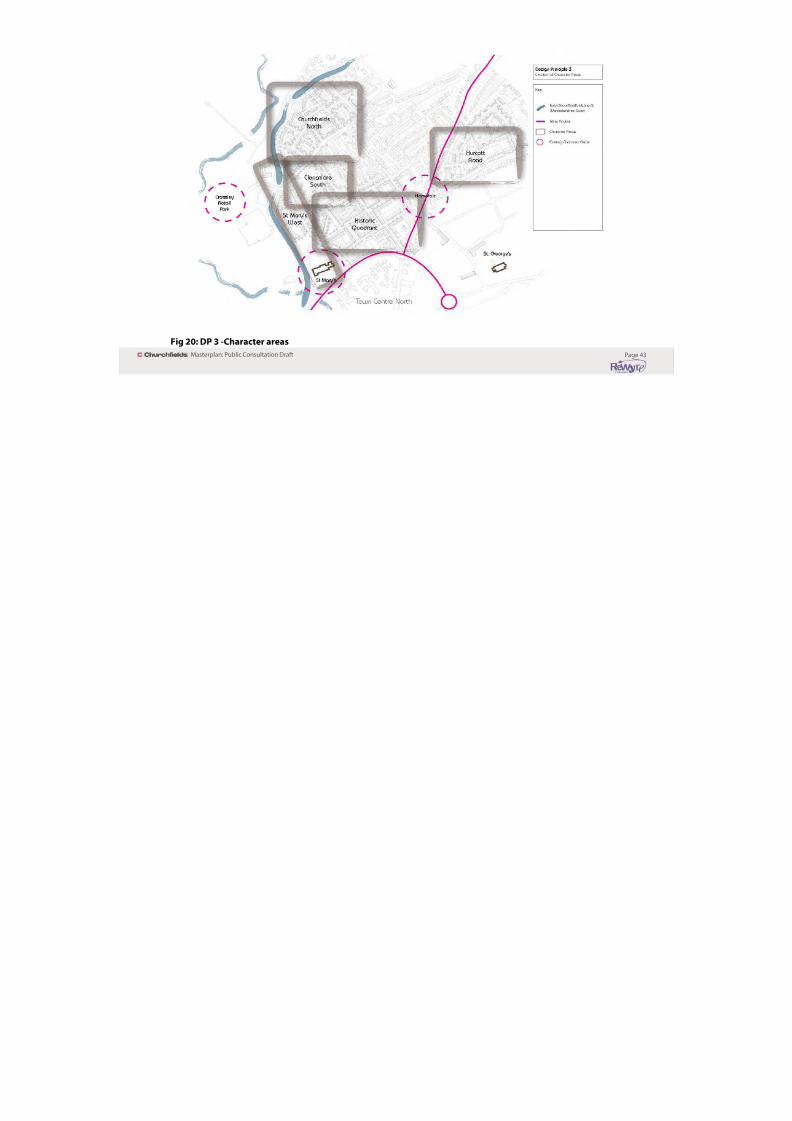
Design principle 3: ‘Creation o character areas and
8/3/2019 Adoption Church Fields Master Plan FINAL (Reduced)
http://slidepdf.com/reader/full/adoption-church-fields-master-plan-final-reduced 44/68
Page 42Masterplan: Public Consultation Drat
Design principle 3: Creation o character areas and
a legible development’
• Provide ve new character areas to dene place.
• Selective use of landmark buildings to terminate vistas
and dene active spaces and junctions.
• Integrate heritage assets and open spaces to strengthen
character.
• Integrate a variety of multi-functional spaces and squares to
dene character.
• Make the most of landmarks, views and vistas.
• Plan for phasing - the sites will need to be developed in
stages. Dierent developers can leave their own mark, but
they must work within the guidelines o the masterplan andmake an appropriate contribution towards the area-wide
benets package.
DP3: Consultation Feedback Heritage proved to be a contentious issue. Although people
were exceptionally proud o their area and the history o
Churchelds, the eeling was that the past was holding back the area.
The wider public view in Kidderminster, however, was that
Churchelds was a special place that needed to preserve its
historic value.

8/3/2019 Adoption Church Fields Master Plan FINAL (Reduced)
http://slidepdf.com/reader/full/adoption-church-fields-master-plan-final-reduced 45/68
Page 43Masterplan: Public Consultation Drat
Fig 20: DP 3 -Character areas
Design Principle 4: ‘Provide a positive rontage to

8/3/2019 Adoption Church Fields Master Plan FINAL (Reduced)
http://slidepdf.com/reader/full/adoption-church-fields-master-plan-final-reduced 46/68
Page 44Masterplan: Public Consultation Drat
Design Principle 4: Provide a positive rontage to
the Staordshire & Worcestershire Canal’
All development should ront onto the canal by one or•
more o the ollowing techniques:
Multi-modal street rontages (essential at least1.
in part on the main development site at the ormer
Georgian Carpet actory).
Pedestrian public right o way in ront o development2.
(publicly adopted or privately owned/ maintained)
with high quality and private parking courts at therear.
Ensure the architectural treatment o buildings relates•
well to the waterside setting and oers a richness andvariety o style and modulation.
Create a sae, secure, and crime ree environment•with quality surace treatment and quality landscape
treatment and appropriate levels o pedestrian lighting.
Without prejudice to the above, make appropriate•
provision or biodiversity (on and/or o site) to enhance
the green inrastructure network in the area .
Explore the scope or residential moorings within the•
waterside developments at Crossley Park and Clensmore.
DP4: Consultation Feedback
The public was unanimous in their view that the canal was
o outstanding natural and historic beauty.
8/3/2019 Adoption Church Fields Master Plan FINAL (Reduced)
http://slidepdf.com/reader/full/adoption-church-fields-master-plan-final-reduced 47/68
Page 45Masterplan: Public Consultation Drat
Fig 21: DP4 - Frontages
Design Principle 5: ‘Create a series o new public

8/3/2019 Adoption Church Fields Master Plan FINAL (Reduced)
http://slidepdf.com/reader/full/adoption-church-fields-master-plan-final-reduced 48/68
Page 46Masterplan: Public Consultation Drat
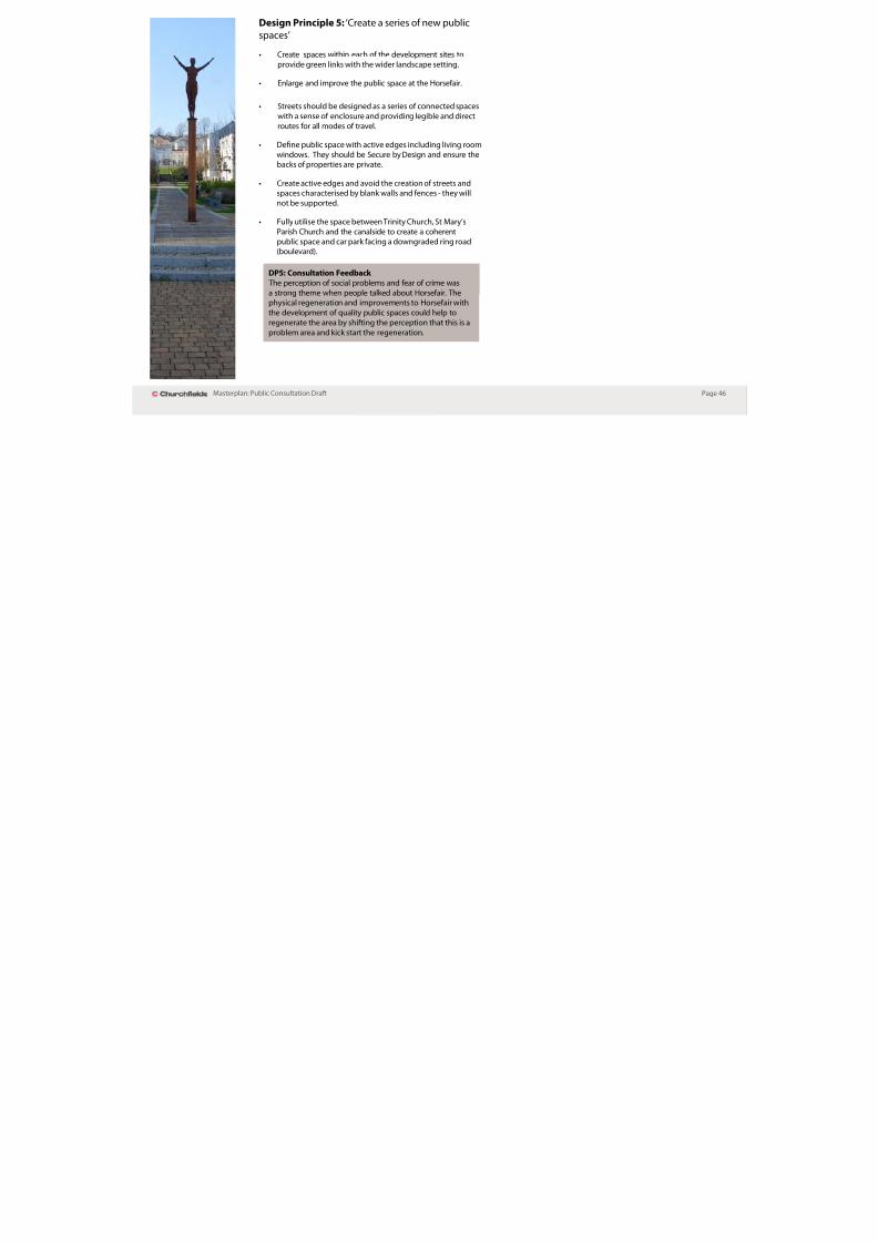
Design Principle 5: Create a series o new public
spaces’
• Create spaces within each of the development sites to
provide green links with the wider landscape setting.
• Enlarge and improve the public space at the Horsefair.
• Streets should be designed as a series of connected spaces
with a sense o enclosure and providing legible and directroutes or all modes o travel.
• Dene public space with active edges including living room
windows. They should be Secure by Design and ensure thebacks o properties are private.
• Create active edges and avoid the creation of streets andspaces characterised by blank walls and ences - they will
not be supported.
• Fully utilise the space between Trinity Church, St Mary’sParish Church and the canalside to create a coherent
public space and car park acing a downgraded ring road(boulevard).
DP5: Consultation Feedback
The perception o social problems and ear o crime was
a strong theme when people talked about Horseair. Thephysical regeneration and improvements to Horseair with
the development o quality public spaces could help to
regenerate the area by shiting the perception that this is a
problem area and kick start the regeneration.
8/3/2019 Adoption Church Fields Master Plan FINAL (Reduced)
http://slidepdf.com/reader/full/adoption-church-fields-master-plan-final-reduced 49/68
Page 47Masterplan: Public Consultation Drat
Fig 22: DP5 - New public spaces
Design Principle 6: ‘Integrate existing heritage

8/3/2019 Adoption Church Fields Master Plan FINAL (Reduced)
http://slidepdf.com/reader/full/adoption-church-fields-master-plan-final-reduced 50/68
Page 48Masterplan: Public Consultation Drat
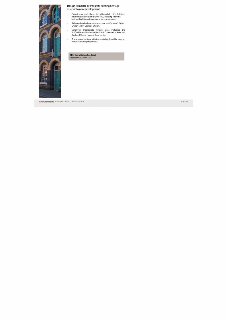
Design Principle 6: Integrate existing heritage
assets into new development’
• Protect, reuse and enhance the setting of all Listed Buildings
(including locally listed) e.g. the 1902 building and other
heritage buildings o complementary group value.
• Safeguard and enhance the open spaces at St Mary’s Parish
Church and St George’s Church.
• Sensitively incorporate historic areas including theStaordshire & Worcestershire Canal Conservation Area and
Blackwell Street/ Horseair local centre.
• A townscape heritage initiative or similar should be used to
enhance existing shop ronts.
DP6: Consultation Feedback
See eedback under DP3.

8/3/2019 Adoption Church Fields Master Plan FINAL (Reduced)
http://slidepdf.com/reader/full/adoption-church-fields-master-plan-final-reduced 51/68
Page 49Masterplan: Public Consultation Drat
Fig 23: DP6 - Heritage assets
Design Principle 7: ‘High quality architecture and

8/3/2019 Adoption Church Fields Master Plan FINAL (Reduced)
http://slidepdf.com/reader/full/adoption-church-fields-master-plan-final-reduced 52/68
Page 50Masterplan: Public Consultation Drat
g p g q y
nish’
• Building forms should respond positively to context with
variety, rhythm and richness across the area and internally
within larger developments.
• Ensure mass and land use reects the location within thelayout including key junctions and spaces and the hierarchy
o streets.
• The larger and more important the street and/ or space the
greater the height and mass that may be appropriate to
create an appropriate sense o enclosure and vibrancy.
• Apply a design code to a specication agreed by the District
Council based on the Design Quality Supplementary PlanningGuidance.
Incorporate Secure by Design principles to reduce•
opportunities or crime and anti-social behaviour
• Incorporate high quality materials in the design of street
urniture, suraces and landscaping including semi-mature
planting.
• Demonstrate sustainability, adaptability and exibility of
use.
• Incorporate energy eciency and renewable energy
measures
Incorporate water eciency measures, including SUDS•
• Incorporate or make a contribution towards public art in the
local neighbourhood

8/3/2019 Adoption Church Fields Master Plan FINAL (Reduced)
http://slidepdf.com/reader/full/adoption-church-fields-master-plan-final-reduced 53/68
Page 51Masterplan: Public Consultation Drat
Fig 24: DP7 - High quality architecture
Design Principle 8: ‘Vibrant mixed communities’ Design Principle 9: ‘Deliverable and realistic’

8/3/2019 Adoption Church Fields Master Plan FINAL (Reduced)
http://slidepdf.com/reader/full/adoption-church-fields-master-plan-final-reduced 54/68
Page 52Masterplan: Public Consultation Drat
g p
• Combine layouts, building form, orientations and land uses
to maximise vibrancy at strategically positioned nodes and
along key movement corridors.
• Provide a mix of tenures and types of housing within
residential developments. This includes specialist housingor elderley care.
• Integrate community facilities and commercial development
at every opportunity.
• Safeguard, enhance and improve connections to
community assets including the local centre, meetingrooms, religious buildings, open spaces and Puxton Marsh
SSSI.
• Provide a more attractive environment for boaters includingopportunities or mooring along the canal.
• Serve to strengthen the vitality and viability of the town
centre as the main employment, retail and service centre
by improving links or new residents and business.
• Suitably incorporate car parking to include a variety of
approaches appropriate to site context including on-street,
in-plot, shared parking, parking courts, multi-unctional
squares and undercrot parking.
Care should be taken with parking courts to ensure they•
are secure by design and are private spaces that have an
instrinsic residential amenity value.
g p
Proposals that ail to demonstrate consistency with the design
principles o this masterplan will be reused unless the applicant
can demonstrate very special circumstances in terms o viability
DP8: Consultation Feedback The development o new housing to create a ‘vibrant and
mixed community’, was supported by the local community.However, this needs to be consistent with the environmental
carrying capacity o the area. The community expressed
concerns about the rise in people demanding new acilities
and increasing trac. Development needs to be appropriatein scale to Churchelds and capacity will be considered urther
as part o the delivery and implementation strategy within the
masterplan.
8/3/2019 Adoption Church Fields Master Plan FINAL (Reduced)
http://slidepdf.com/reader/full/adoption-church-fields-master-plan-final-reduced 55/68
Page 53Masterplan: Public Consultation Drat
Fig 25: DP8 - Vibrant communities
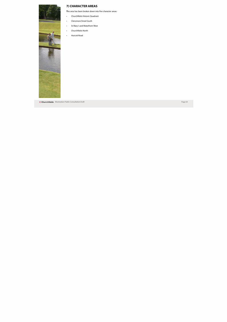
7) CHARACTER AREAS

8/3/2019 Adoption Church Fields Master Plan FINAL (Reduced)
http://slidepdf.com/reader/full/adoption-church-fields-master-plan-final-reduced 56/68
Page 54Masterplan: Public Consultation Drat
)
The area has been broken down into ve character areas:-
• Churchelds Historic Quadrant
Clensmore Street South•
• St Mary’s and Waterfront West
• Churchelds North
• Hurcott Road

8/3/2019 Adoption Church Fields Master Plan FINAL (Reduced)
http://slidepdf.com/reader/full/adoption-church-fields-master-plan-final-reduced 57/68
Page 55Masterplan: Public Consultation Drat
Fig 26: Snapshot o Character Areas
Churchfelds Historic Quadrant

8/3/2019 Adoption Church Fields Master Plan FINAL (Reduced)
http://slidepdf.com/reader/full/adoption-church-fields-master-plan-final-reduced 58/68
Page 56Masterplan: Public Consultation Drat
1) Maintain views towards St Mary’s Church
2) Retain church/ community facility
3) Car parking at centre of block4) Potential new hotel to provide new landmark
building at gateway to Churchfields
5) Removal of roundabout and provision of newsignalized junction
6) New landmark building at junction of Blackwell
Street7) New one-way link – North West
8) New one- way link – South West. Pavements to be
widened and provision of on street parking9) New mews style development
10) New public space at the Horsefair
11) Potential new on street public parking12) Retention of 1902 building – conversion to new
office space
13) Raised table giving greater priority to pedestrians14) Maintain pinch point between locally listed
buildings
15) Provision of on-street parking16) Provision of courtyard parking to reduce impact on
street scene
17) Creation of new green public space overlooked andenclosed by surrounding development. The creation
of a new vista to St Mary’s Church
18) New tree lined street connecting Broad Street withClensmore Street
19) Pedestrian/ cycle connection to York Street
20) New residential development21) Retention of building of heritage value
22) New mixed use development
1
2
34
5
6
8
9
10
11
12
13
14
15
16
17
18
19
20
21
22
7
Vistas
The character o this area is infuenced by the industrial and building heritage. This area will have a mix o uses including residential,oces, commercial, hotel, small-scale retail, and leisure uses.
An industrial urban eel to the area will be created through the retention o historic buildings. New development will create a tight
urban orm based on an urban grid. Some routes will provide important sightlines to St Mary’s Church, while landmark buildings will
terminate others. Development will tend to be back o ootway with parking provided on street and in rear parking courtyards. A new
public car park will be provided at the centre o this area as well as new and improved public spaces at the Horseair and behind what was
historically Duke’s Place.
Fig 27: Churchfelds Historic Quadrant
Clensmore Street South

8/3/2019 Adoption Church Fields Master Plan FINAL (Reduced)
http://slidepdf.com/reader/full/adoption-church-fields-master-plan-final-reduced 59/68
Page 57Masterplan: Public Consultation Drat
The character o this area is infuenced by the topography o the site and viewsacross the Stour Valley. This area should include a mix o residential properties
including detached, semi-detached and terraced. A new pedestrian and cycle
route should connect development rom the Churchelds Historic Quadrantdown to Clensmore Street. A pedestrian connection should also be maintained
to York Street. A new park should be provided which is well overlooked by
surrounding development.
1) Retention of retaining wall and mature landscape
2) Creation of residential block taking into account the
topography of the site and splendid views3) Shared surface road – pedestrian priority
4) New pedestrian link
5) New pedestrian link6) New residential development at lower level to
provide good natural visual surveillance of new
public space7) Trees to be selectively thinned to create usable
public space
8) New residential development fronting onto publicopen space and Clensmore Street
9) Retention of mature landscape
10) Innovative architecture to take into account changein levels. Provision of terraced garden
11) Provision of landmark building to terminate vista12) New residential development to complete
perimeter block
1
2
3
4
5
6
8
9
10
11
12
7
Provision of visual
connections with canal
Fig 28: Clensmore Street South
St Mary’s and Waterront West

8/3/2019 Adoption Church Fields Master Plan FINAL (Reduced)
http://slidepdf.com/reader/full/adoption-church-fields-master-plan-final-reduced 60/68
Page 58Masterplan: Public Consultation Drat
The character o this area is infuenced by the dominance o St Mary’s Church and its landscape setting as well as views down onto theStaordshire & Worcestershire Canal. New development adjacent to the canal should provide an active rontage onto it and increased
natural surveillance. A new pedestrian/ cycle bridge link should be provided across the Staordshire & Worcestershire Canal to improve
connectivity to Crossley Retail Park. The area should include a mix o uses including residential, commercial and leisure uses.
1) Protection of green space that provides setting for
St Mary’s Church
2) New pedestrian/ cycle link across canal to Crossley
retail park
3) Mixed use development to front onto the canal
4) Development to front onto Clensmore Street
5) Provision of new tree planting on Clensmore Street
6) Provision of courtyard parking
7) New landmark building
8) Provision of new multi- modal bridge to improve
connectivity
9) New commercial development on opposite side of
the canal
1
2
3
4
5
6
8
9
7
Fig 29: St. Mary’s and Waterront West
Churchfelds North
8/3/2019 Adoption Church Fields Master Plan FINAL (Reduced)
http://slidepdf.com/reader/full/adoption-church-fields-master-plan-final-reduced 61/68
Page 59Masterplan: Public Consultation Drat
Residential development in Churchelds North should ront onto the canal toprovide good natural visual surveillance. The provision o a trac-calmed street
will allow vehicular access to ront doors, creating activity and security. Visual and
physical connections should be provided rom Clensmore Street to the canal inorder to reinorce the importance o the canal. A new central space will also help
to meet some o the recreational needs o the proposed development including
the need or children’s play space.
1) Provision of a new pedestrian/ cycle bridge
2) Provision of a new arrival space
3) Shared surface street adjacent to the canal to allow
access to front doors
4) Provision of on street parking
5) Development to back onto high wall to form an
enclosed perimeter block
6) Provision of secure perimeter blocks that are small
to improve overall connectivity
7) Provision of new central open space to include
children’s play facilities
8) Create visual and physical connections with canal
from Clensmore Street
9) Provision of mews style development
10) Provision of landmark corners to provide a
gateway to Churchfield North11) Provision of new landmark Apartment building with
potential mixed use on the ground floor
12) Provision of pedestrian and cycle route alongside
the canal
13) Varied street type alongside the canal to allow
vehicular access along small stretches to improve
pedestrian priority.
1
2
3
4
5
6
8
9
10
1112
7
Provision of visual
connections with canal
13
Fig 30: Churchfelds North
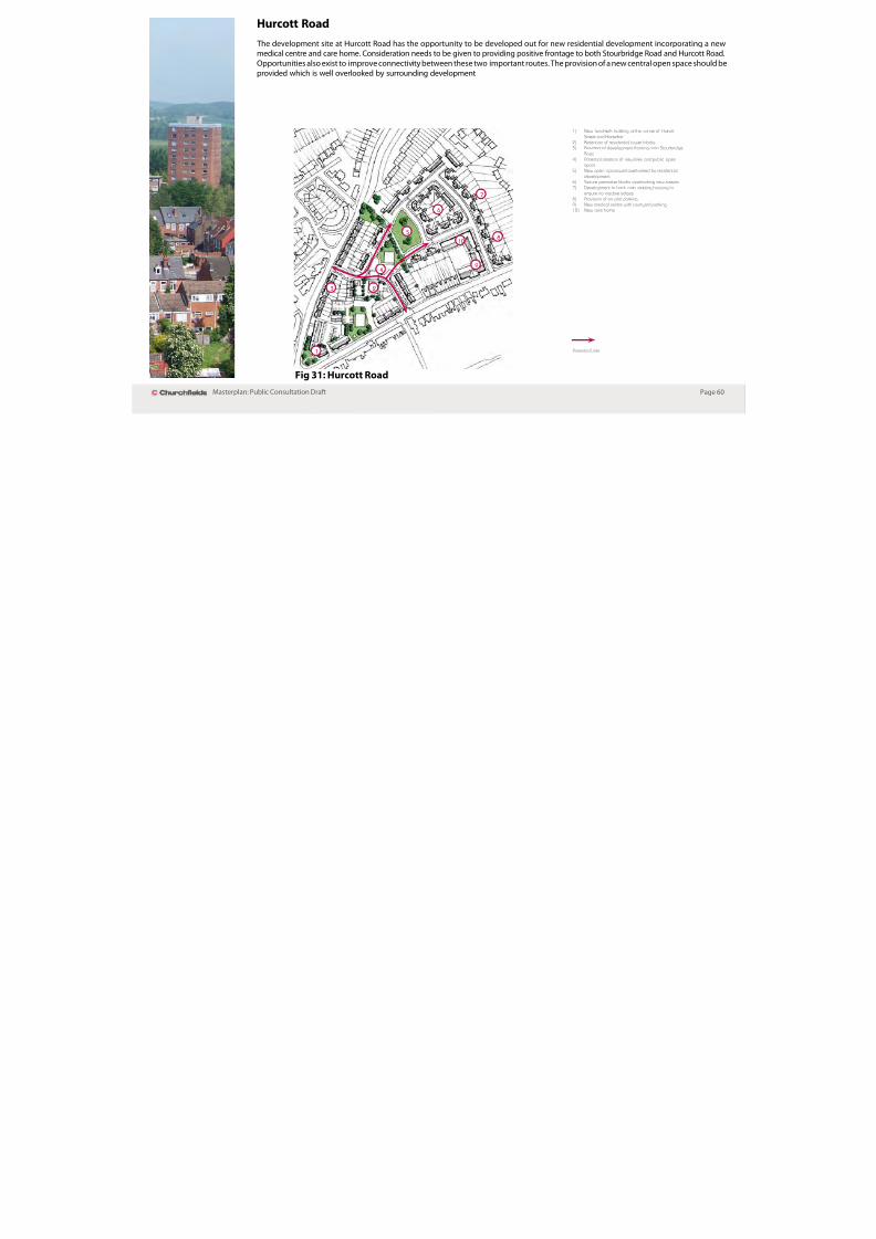
Hurcott Road
8/3/2019 Adoption Church Fields Master Plan FINAL (Reduced)
http://slidepdf.com/reader/full/adoption-church-fields-master-plan-final-reduced 62/68
Page 60Masterplan: Public Consultation Drat
The development site at Hurcott Road has the opportunity to be developed out or new residential development incorporating a newmedical centre and care home. Consideration needs to be given to providing positive rontage to both Stourbridge Road and Hurcott Road.
Opportunities also exist to improve connectivity between these two important routes. The provision o a new central open space should be
provided which is well overlooked by surrounding development
1) New landmark building at the corner of Hurcott
Street and Horsefair
2) Retention of residential tower blocks3) Residential development fronting onto Stourbridge
Road
4) Potential creation of new links and public openspace
5) New open space well overlooked by residential
development6) Secure perimeter blocks overlooking new streets
7) Development to back onto existing housing to
ensure no inactive edges8) Provision of on-plot parking
9) New medical centre with courtyard parking10) New care home
Potential Links1
23
4
5
6
8
9
10
7
Fig 31: Hurcott Road
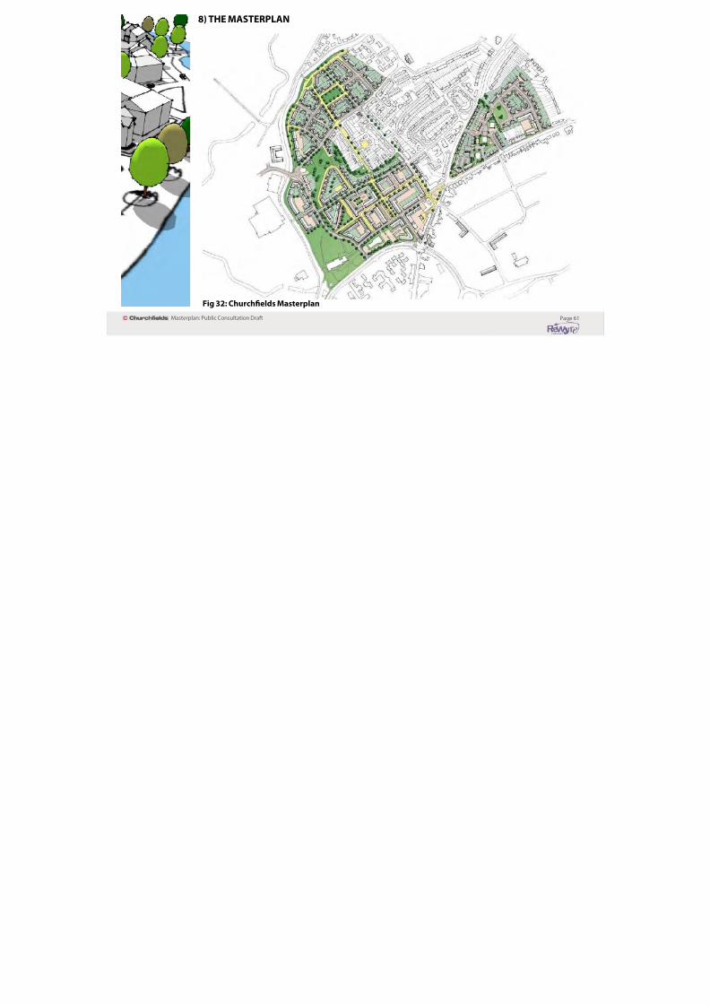
8) THE MASTERPLAN

8/3/2019 Adoption Church Fields Master Plan FINAL (Reduced)
http://slidepdf.com/reader/full/adoption-church-fields-master-plan-final-reduced 63/68
Page 61Masterplan: Public Consultation Drat
Fig 32: Churchfelds Masterplan
project o the size o Churchelds9) DELIVERY & IMPLEMENTATION

8/3/2019 Adoption Church Fields Master Plan FINAL (Reduced)
http://slidepdf.com/reader/full/adoption-church-fields-master-plan-final-reduced 64/68
Page 62Masterplan: Public Consultation Drat
However, it is acknowledged that there will be a limit to the amount
that can be levied through S106 or Community Inrastructure Levycontributions without breaching viability.
Thereore inrastructure has been prioritised accordingly, to givecertainty and condence to developers and landowners. The
priority inrastructure project or Churchelds is the proposed
works to St Mary’s Ringway and the more generic highways
improvements/pedestrian links to the wider Churchelds area.
Further inrastructure priorities will be considered alongside
the phasing o individual sites to ensure that delivery o vital
inrastructure does not constrain development.
Viability
Bruton Knowles were appointed by Wyre Forest District Council to
provide commercial property advice in relation to the suitability,viability and delivery o the Masterplan proposals in the context o
current market conditions.
Bruton Knowles have appraised the component areas o theMasterplan and have concluded that the proposed uses are
sustainable in terms o both viability and market appeal, andcurrently deliver positive land values.
Whilst overall land values are considered positive, in some instances
these will be close to viability thresholds in the current market, due
to the impact o high abnormal costs required or site preparation
to remove existing uses and resolve historic contamination.However, this should not hinder development coming orward
or preclude the delivery o the proposed highways/inrastructure
works outlined in the Masterplan. It is thereore essential that afexible approach to viability and delivery is adopted, alongsidethe prioritisation o inrastructure requirements and alignment o
nancial contributions with a mix o unding sources.
Inrastructure Prioritisation
Highways and inrastructure proposals are an integral component
o the master plan, restoring access and resolving existinghighways problems. Bruton Knowles consider that the proposals
are deliverable, although some cooperation rom landowners will
be required.
The total costs to deliver the indicative highway and inrastructure
requirements set out in the Masterplan is understood to be in theregion o £4.2m. This is considered reasonable or a regeneration
10) FUNDING MECHANISMS
The District Council recognises that the economics o residentialdevelopment may mean that not all o the expectations can be

8/3/2019 Adoption Church Fields Master Plan FINAL (Reduced)
http://slidepdf.com/reader/full/adoption-church-fields-master-plan-final-reduced 65/68
Page 63Masterplan: Public Consultation Drat
It is recognized that market conditions are subject to change,
and that these circumstances can impact on the viability o
development. Consequently, in order to achieve the master planthere will be a requirement or a fexible approach to negotiations
at planning application stage to ensure viability and that the
delivery o an acceptable scheme is not constrained or delayed.
Planning obligations
A legal agreement under Section 106 o the Town and Country
Act (1990) (as amended) will be required which could contain
provisions including nancial contributions in the ollowingpriority order:
• O-site highway works.
• Public Transport (for commercial development).
• Aordable housing (for proposals involving residentialdevelopment).
Additional Section 106 contributions will also be sought as part o
site specic proposals to include (in alphabetical order):
Drainage Inrastructure.•
Education.•
• O-site improvements to cycle and pedestrian routes.
• Open space, play provision and maintenance.
• Public art.
• Upgrade of Police Post.
The above priorities refect the core design principles or the site
and the adopted Wyre Forest District Planning Obligations SPD.
development may mean that not all o the expectations can be
delivered directly rom the developers via s.106 contributions. In
this respect, any departure rom this masterplan and associated
DPD policies will need to be robustly justied with an open book viability exercise. It will also be necessary to demonstrate that
the attainment o the overall masterplan objectives will not be
adversely compromised or prejudiced.
Other unding mechanisms
Whilst post recession unding options or regeneration deliveryhave been reduced, a range o new unding sources are evolving
that are applicable to regeneration schemes.
The District Council will consider utilising a blend o unding
sources to assist in delivery, including Tax Increment Funding
(TIF) and New Homes Bonus (NHB) when relevant legislation is in
place.
11) PHASING
8/3/2019 Adoption Church Fields Master Plan FINAL (Reduced)
http://slidepdf.com/reader/full/adoption-church-fields-master-plan-final-reduced 66/68
Page 64Masterplan: Public Consultation Drat
In terms o the phasing o the development, it is anticipated that Grassmere Close and the most northern area adjoining the Staordshire
and Worcestershire Canal as being the initial points o regeneration, with the development phasing moving southwards towards the
ring road with the later part o the regeneration in the areas close to St Mary ’s Church.
Fig 33: Approximate Site Phasing Plan
12) PLANNING APPLICATIONS Design - how the proposed design o the development willdeal with any potential conficts between the proposed

8/3/2019 Adoption Church Fields Master Plan FINAL (Reduced)
http://slidepdf.com/reader/full/adoption-church-fields-master-plan-final-reduced 67/68
Page 65Masterplan: Public Consultation Drat
Planning applications will be expected to comply with the WyreForest District Council Local Development Framework, including
the Adopted Core Strategy (2010), the emerging Development Plan
Documents, and all relevant Supplementary Planning Documentsand Guidance.
Design and Access Statement
It is a ormal requirement or a design and access statement to
accompany most types o planning application. ‘Guidance oninormation requirements and validation’ indicates that statements
should explain the design thinking and principles that have
inormed the development and how access issues have been dealt
with. In short, a statement should detail:
Use - what buildings and spaces will be used or.
Amount - how much will be built on site.
Layout - how the buildings and public and private spaces
will be arranged on the site, and the relationship between
them and the buildings and spaces around the site.
Scale - how big the buildings and spaces will be (their
height, width and length).
Landscaping - how open spaces will be treated to enhanceand protect the character o a place.
Appearance - what the buildings and spaces will look like.
Access - why the access points and routes have been chosen,
and how the site responds to road layout, including howeveryone can get to and move through the place on equal
terms.
y p p p
use on the site and the activities taking place in the public
open spaces. It must also ensured that development will
not unreasonably aect the current recreational activitiesenjoyed by the community.
The Commission or Architecture and the Built Environment
(CABE) has produced best practice guidance on ‘Design andAccess Statements: how to write, read and use them’ (2006).
Landscape strategy
Developers will be expected to provide inormation as to how thelandscape will be maintained during the establishment period
(usually ve years).
Achieving sustainable design
It will be essential that planning applications clearly demonstrate
how the development meets standards set by the SustainableDevelopment Supplementary Planning Guidance and supporting
checklist. It should also meet the sustainability criteria set outin the adopted Core Strategy and emerging Development Plan
Documents.
13) CONTACTS

8/3/2019 Adoption Church Fields Master Plan FINAL (Reduced)
http://slidepdf.com/reader/full/adoption-church-fields-master-plan-final-reduced 68/68
Page 66Masterplan: Public Consultation Drat
For more inormation on the ReWyre Initiative and theRegeneration Prospectus, as well as other regeneration initiatives
and sites, please visit our website at www.wyreorestdc.gov.uk.
I you are a landowner, developer or investor interested in
regeneration opportunities within the Churchelds Masterplan
area, please contact the Regeneration Team at:
Email: [email protected]
Telephone: 01562 732192
For more inormation on the Wyre Forest Local Development
Framework, including the Kidderminster Central Area Action Plan
Development Plan Docment, then please also visit the websiteabove.
Alternatively you can contact the Planning Policy Team at:
Planning PolicyWyre Forest District Council
Duke House
Clensmore Street
KidderminsterDY10 2JX
Or why not send us an e-mail or give us a call:
E-mail: [email protected]
Telephone: 01562 732928