Adjusting Hydrologic Soil Groups for Post-Construction ... Hydrologic Soil Groups for...
41
Adjusting Hydrologic Soil Groups for Post-Construction Conditions and Their Effects on Hydrology Calculations September 8, 2016 Jay Dorsey OH2O Water Resources Engineering Joseph Miller Banning Engineering
Transcript of Adjusting Hydrologic Soil Groups for Post-Construction ... Hydrologic Soil Groups for...

Adjusting Hydrologic Soil Groups for Post-Construction Conditions and Their Effects on Hydrology
Calculations
September 8, 2016
Jay DorseyOH2O Water Resources Engineering
Joseph MillerBanning Engineering

Overview of PresentationNRCS guidance for curve numbers and
urban hydrology (incl. urban soils) Soil profile modification during land
conversionOhio adjustment to HSG (and CN) for
urban soils

NRCS Curve Number GuidanceNational Engineering Handbook, Part 630
Hydrology Chapter 10 – Estimation of Direct Runoff from
Storm Rainfall (July 2004) Chapter 9 – Hydrologic Soil-Cover Complexes
(July 2004) Chapter 7 – Hydrologic Soil Groups (January
2009)

NRCS Curve Number GuidanceNational Engineering Handbook, Part 630
Hydrology Chapter 7 – Hydrologic Soil Groups (January
2009)

Hydrologic Soil Group (HSG) Hydrologic Soil Group for a limited group of soils
was assigned based on measured rainfall, runoff, and infiltrometer data.
State and NRCS soil scientists assigned HSG for all other (i.e., non-measured) soils based on: Soil properties (texture, structure) Intake and transmission of water Depth to restrictive layer Depth to water table
NRCS. 2009. Hydrologic Soil Groups. Ch. 7, NEH 630 – Hydrology.

Hydrologic Soil Group (HSG) The procedure for assigning HSG was more
explicitly defined in May 2007 revision to NEH 630, Chapter 7 – Hydrologic Soil Groups.
NRCS. 2007. Hydrologic Soil Groups. Ch. 7, NEH 630 – Hydrology.

Hydrologic Soil Group (HSG) The procedure for assigning HSG was more
explicitly defined in May 2007 revision to NEH 630, Chapter 7 – Hydrologic Soil Groups.
NRCS turned update of HSGs over to state NRCS offices.
HSGs for Ohio soils were updated by Ohio NRCS staff in 2008 based on new protocol.
Updated Ohio HSGs submitted to national NRCS office, incorporated in the national soils database and are now available through Web Soil Survey.
NRCS. 2007. Hydrologic Soil Groups. Ch. 7, NEH 630 – Hydrology.
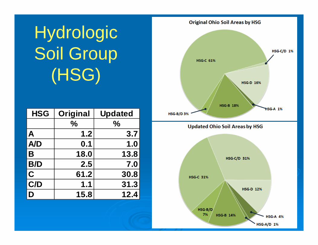
Hydrologic Soil Group
(HSG)
HSG Original Updated% %
A 1.2 3.7A/D 0.1 1.0B 18.0 13.8B/D 2.5 7.0C 61.2 30.8C/D 1.1 31.3D 15.8 12.4

Hydrologic Soil Group (HSG) NEH 630, Chapter 7 –
Hydrologic Soil Groups was revised again in January 2009.
NRCS. 2009. Hydrologic Soil Groups. Ch. 7, NEH 630 – Hydrology.

NRCS Urban Hydrology Guidance Technical Release 55 (TR-55) Urban
Hydrology for Small Watersheds Last updated June 1986 Supplemental information available at NRCS
website

NRCS Urban Hydrology Guidance
NRCS. 1986. Urban Hydrology for Small Watersheds. Technical Release 55 (TR-55).
HSGs in TR-55 (and likely in other state/local guidance) are out of date. Pre-development HSGs for soils should be determined from NRCS’s Web Soil Survey.

NRCS Urban Hydrology Guidance
NRCS. 2004. Hydrologic Soil-Cover Complexes. Ch. 9, NEH 630 – Hydrology.

NRCS Urban Hydrology Guidance
NRCS. 2004. Hydrologic Soil-Cover Complexes. Ch. 9, NEH 630 – Hydrology.


CNC = 74CND = 80 CN = ??

CN = ??Probably>90
Built 1962

HSG-A“sandy”
HSG-B“loamy”
HSG-Csilty & clay
loams
HSG-Dclays &
other soils w/issues
CN 39 61 74 80Ia 3.1” 1.3” 0.7” 0.5”
Abstraction Depth for “Open Space in Good Condition”

NRCS Urban Hydrology Guidance
NRCS. 2004. Hydrologic Soil-Cover Complexes. Ch. 9, NEH 630 – Hydrology.

How to Determine HSG for Disturbed Soils?
NRCS. 1986. Urban Hydrology for Small Watersheds. Technical Release 55 (TR-55).


How to Determine HSG for Disturbed Soils?
NRCS. 1986. Urban Hydrology for Small Watersheds. Technical Release 55 (TR-55).

How to Determine HSG for Disturbed Soils?
NRCS. 1986. Urban Hydrology for Small Watersheds. Technical Release 55 (TR-55).

Soil Compaction

Soil Profile Comparison
Depth(in)
Pre-development
03
12
Disturbed
48
30
18
Ks = 0.6 in/hr
Ks = 0.06 in/hr
Ks ~ 0 in/hr
Ks = 0.6 in/hr
Ks = 0.06 in/hr
Ks ~ 0 in/hr
Ks ~ 0 in/hr

Undeveloped Soil Profile

Disturbed Soil Profile
Compacted
Fill

Post-disturbanceHydrologic Soil Group (HSG)
NRCS. 2007. Hydrologic Soil Groups. Ch. 7, NEH 630 – Hydrology.

Rainwater and Land Development
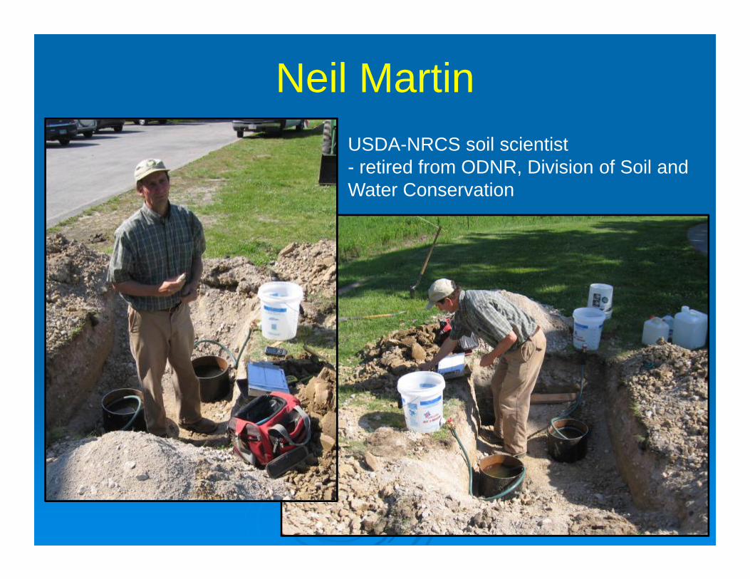
Neil MartinUSDA-NRCS soil scientist- retired from ODNR, Division of Soil and Water Conservation

HSG Adjustment Procedure Removal of the top 18
inches of soil. Compaction of the top 6
inches of the resulting soil. Use texture and adjusted
bulk density in the Soil Water Characteristics calculator to estimate Ksat.
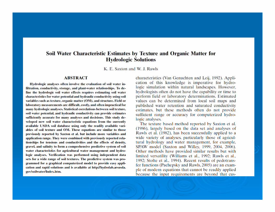

Soil Water Characteristics Calculator
http://hydrolab.arsusda.gov/soilwater/Index.htm

Using Soil Water Characteristics Calculator to Estimate Adjusted Ksat
1. Select soil texture class based on soil survey
2. Reduce organic matter to 0.5%
3. Increase “Compaction” to 1.10
4. Read Sat. Hydr. Cond.

HSG Adjustment Procedure Removal of the top 18
inches of soil. Compaction of the top 6
inches of the resulting soil. Use texture and adjusted
bulk density in the Soil Water Characteristics calculator to estimate Ksat.
Use NRCS guidance to assign HSG.

Pre-ConstrHSG
Post-Constr HSG Number
A A 16B 4C 8D 5
B A 2B 2C 21D 35
C C 8D 66
D, /D D 300A, B, C Not Rated 101
Post-development HSG

RecommendationsFor post-development Curve Numbers: Undisturbed areas can be treated as “open space
in good condition.” For all disturbed areas use post-construction
HSGs published in Rainwater and Land Development Manual.
Ohio EPA staff are developing guidelines for soil renovation criteria to improve soil function and HSG.

Stu Schwartz Photos

Stu Schwartz Graphic
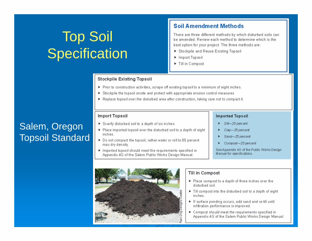
Top Soil Specification
Salem, OregonTopsoil Standard

CNC = 74CND = 80
Infiltration Capacity> 0.5 in/hr
Abstraction DepthHSG-C > 0.75”HSG-D > 0.5”
Functional Urban Soils

Questions:
Jay DorseyOH2O Water Resources Engineering(614) [email protected]
Joseph MillerBanning Engineering(317) [email protected]
OH2OWater ResourcesEngineering