Adams County Farmland Preservation Plan
55
Prepared by: North Central Wisconsin Regional Planning Commission December 2016 Adams County Farmland Preservation Plan
Transcript of Adams County Farmland Preservation Plan

Prepared by: North Central Wisconsin Regional Planning Commission
December 2016
Adams County Farmland Preservation Plan

Acknowledgments
Adams County’s Farmland Preservation Plan was developed with the following residents and staff. Special thanks are extended to the following people: Land and Water Resources and Recreation Committee
Barb Morgan, Chair Kevin Bork Karch Onufry Dan Wysocky
Florence Johnson, Vice Chair
Fred Nickel Paul Pisellini
Planning and Zoning Committee
Rocky Gilner, Chair Fred Nickel Larry Borud Randy Theisen
Barb Morgan, Vice Chair Larry Babcock Al Sebastiani
Advisory Committee
Richard Matzke Adams County Lake Alliance member, concerned citizen Aaron J Bonnett Farmer, concerned citizen June Hesler Farm owner, concerned citizen Bill Parr Real Estate Agent / Broker, concerned citizen Bill Euclide Woodlands owner, concerned citizen Jay Jocham Artist and designer, concerned citizen Staff for this plan
Phil McLaughlin, Adams County Planning & Zoning Administrator
Wally Sedlar County Conservationist, Adams County Land and Water
Fred Heider, AICP, Planner at NCWRPC
Cover Photo: Town of Dell Prairie farm
December 2016
For more information contact: NORTH CENTRAL WISCONSIN REGIONAL PLANNING COMMISSION 210 MCCLELLAN STREET, SUITE 210 WAUSAU, WI 54403
Phone: 715-849-5510 www.ncwrpc.org

Table Of Contents
CHAPTER 1 – INTRODUCTION ....................................................................1 Background .........................................................................1 Overview of WLI/Farmland Preservation Planning ................1 Overview of Current Plan .....................................................2 Plan Maintenance and Amendment ......................................2 CHAPTER 2 – PLANNING PROCESS ............................................................4 Requirements ......................................................................4 Planning Process .................................................................5 CHAPTER 3 – EXISTING CONDITIONS ........................................................7 Issues and Trends ...............................................................7 Anticipated Direction of Agriculture in Adams County..........8 Natural Resources and Environmental Preservation ........... 11 Population, Housing, and Municipal Expansion ................. 12 Utilities and Infrastructure Facilities.................................. 15 Public Ownership .............................................................. 18 Existing Land Use.............................................................. 19 Future Land Use................................................................ 20 CHAPTER 4 - AGRICULTURE & ENVIRONMENT ....................................... 22 Resources and Land Uses .................................................. 22 Farmland Conversion ........................................................ 22 Programs ........................................................................... 23 CHAPTER 5 – ECONOMICS ....................................................................... 25 Agricultural Economic Growth ........................................... 25 Forestry Economic Growth ................................................ 31 CHAPTER 6 – GOALS, OBJECTIVES, POLICIES, & MAPPING CRITERIA .... 32 Goals, Objectives, and Policies ........................................... 32 Mapping Criteria................................................................ 33 CHAPTER 7 – IMPLEMENTATION .............................................................. 35 Implementation Tools ........................................................ 35 Monitoring ......................................................................... 38 Plan Consistency and Amendments ................................... 38
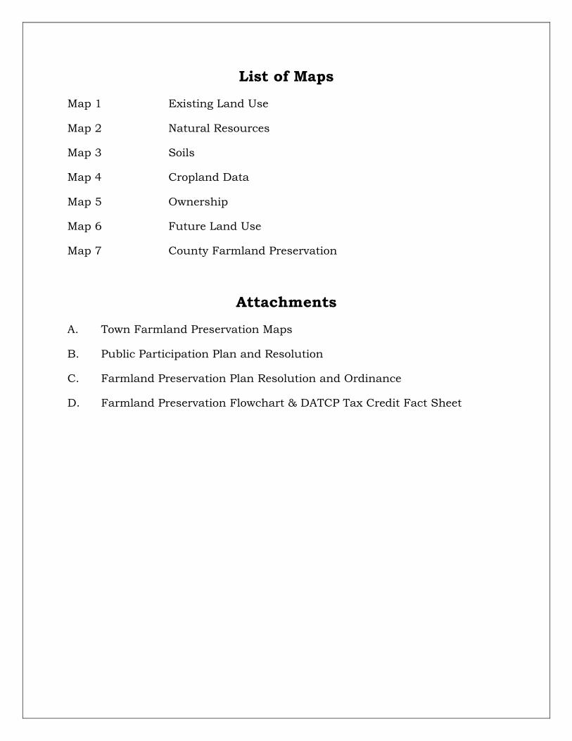
List of Maps
Map 1 Existing Land Use
Map 2 Natural Resources
Map 3 Soils
Map 4 Cropland Data
Map 5 Ownership
Map 6 Future Land Use
Map 7 County Farmland Preservation
Attachments
A. Town Farmland Preservation Maps
B. Public Participation Plan and Resolution
C. Farmland Preservation Plan Resolution and Ordinance
D. Farmland Preservation Flowchart & DATCP Tax Credit Fact Sheet

Adams County 2017 - 1 - NCWRPC Farmland Preservation Plan
CHAPTER 1 INTRODUCTION BACKGROUND In 2010, agriculture constituted a $59 billion industry in Wisconsin. Farmland around the country is being lost at an alarming rate, and, once it is gone, we cannot get it back. Farmland preservation planning is crucial to preserve the agricultural land remaining in Wisconsin, because of the economic importance of agriculture in the State and the potential for loss of our agricultural land base. Much of the best agricultural areas in the nation are located in the upper Midwest, stretching from Ohio to the Dakotas. While Wisconsin does not contain as much prime farmland areas as some of the other upper Midwest states, there are still many areas where agriculture is important. Despite its importance, agriculture faces many challenges, especially in the Northwoods, where the main challenge is a shorter growing season. Other challenges to maintaining successful agriculture are the acidic sandy soils that developed under pine forests; and shallow depth to groundwater, which restricts many agriculturally cultivated plants from growing. OVERVIEW OF WLI/FARMLAND PRESERVATION PLANNING Wisconsin’s Working Lands Initiative (WLI) was adopted in 2009 as part of the 2009-2011 biennial budget. The law is specified in Chapter 91 of Wisconsin State Statutes. The main components include: 1. Modernization of the state’s farmland preservation plans; 2. Establishment of agricultural enterprise areas; 3. Increased tax credit opportunities and certainty of credit value; and 4. Development of the Agricultural Conservation Easement Program. A Farmland Preservation Plan (FPP) provides a vision and guidelines for future growth, development, and land preservation in the County. The plan functions as the primary policy document setting forth directions for how the County

Adams County 2017 - 2 - NCWRPC Farmland Preservation Plan
intends to preserve agricultural production capacity, farmland, soil and water resources, and rural character. These plans also review the economic and cultural importance of agriculture in the County. One of the primary components of a FPP is a set of detailed maps that identify farmland areas for preservation based on locally established criteria. However, creating the Farmland Preservation Plan is only the first step toward tax credit eligibility. After the FPP is completed, then the County, or towns with their own zoning, will need to adopt Farmland Preservation Zoning or create an Agricultural Enterprise Area, and then an eligible landowner may claim a tax credit. See program descriptions in Chapter 7, under: “IMPLEMENTATION TOOLS,” and review DATCP’s Tax Credit fact sheet in Attachment D for details. OVERVIEW OF CURRENT PLAN The most recent Farmland Preservation Plan (FPP) was adopted in 1981. The dated plan is simply a listing of how conservation standards would be met in accordance with Wisconsin State Statutes. Landowners would make sufficient annual progress to ensure that the standards would be met by the end of the schedule of compliance. Each participant would certify in writing every year that they were complying with the soil and water conservation standards required in the plan. PLAN MAINTENANCE AND AMENDMENT The Farmland Preservation Plan is an element of the County’s Comprehensive Plan. On December 31, 2016, the 1981 Farmland Preservation Plan expired. This 2017 Farmland Preservation Plan is intended to fulfill the statutory requirements for both the farmland preservation plan (Chapter 91, Subchapter II, WI Statutes) and the agricultural element of the comprehensive plan (§66.1001(2), Wis. Stats.). Wisconsin Statute §66.1001 requires that an adopted plan be reviewed and updated at least once every ten years. This is not a static plan, but one that may change over time. Changing land uses, policy changes, regulatory

Adams County 2017 - 3 - NCWRPC Farmland Preservation Plan
changes, or shifting economics are some reasons to review if this plan is still current. See Chapter 7, under: “PLAN CONSISTENCY AND AMENDMENTS” for details about how this plan is consistent with the Adams County Comprehensive Plan.

Adams County 2017 - 4 - NCWRPC Farmland Preservation Plan
CHAPTER 2 PLANNING PROCESS The planning process considers existing and future agricultural conditions, the local economy, existing and future growth trends, and current and future prospective participation in the program. The plan tries to coordinate all of this with other agencies who work with landowners, as well as offer the public the opportunity to have input into the planning process. This chapter will discuss the planning process, including public participation. REQUIREMENTS The Farmland Preservation Plan must address certain elements as specified in Chapter 91, Wisconsin Statutes. There are several required plan elements to develop the for farmland preservation plan. Once certified by the state, landowners become eligible for income tax credits. Several meeting were held during the development of this plan. All meetings were held in a public place, easily accessible, and in accordance with the Americans with Disabilities Act. They were advertised well ahead of time, with phone numbers and names of contact persons in case of questions or comments. A public hearing was held as part of the formal plan adoption process and this too was published as required by law. Several objectives were met by holding these meetings: Participants of all races, ethnic backgrounds and economic levels had an equal opportunity to voice their opinion and be involved in the process. All residents of Adams County had an opportunity to be aware of the planning process through the advertisement of the meeting and the stated objective of the Farmland Preservation Plan and mapping criteria. Residents were also offered the opportunity to call or write to voice their comments if they were not able to make them in person. A website was advertised and maintained with all planning documents and a planning schedule on it. Public involvement strengthens the sense of vested interest in the success of the process and in the community as a whole.

Adams County 2017 - 5 - NCWRPC Farmland Preservation Plan
PLANNING PROCESS The Adams County Farmland Preservation Plan was developed during calendar year 2016 in cooperation with the North Central Regional Planning Commission (NCWRPC). To assist in the revision of the Farmland Preservation Plan, Adams County Land Conservation Department & Planning and Zoning Department invited participation from a variety of town representatives, farmers, and citizens. They discussed farming issues and mapped where farmland should be preserved over the next 15 years. Advisory Committee members are listed on the back of this plan’s cover. A chronological history of the plan update activities is as follows:
December 17, 2015 – the first Advisory Committee meeting was held at the Village of Friendship’s Village Hall.
- No business occurred, but background information was discussed for reference.
March – July, 2016 – Development of draft plan text and initial maps.
July 13, 2016 – the second Advisory Committee meeting was held at the Village of Friendship’s Village Hall.
- Initial draft agricultural issues & trends were identified.
- Initial draft goals & objectives were created.
- Initial draft farmland preservation mapping criteria were created.
September 13, 2016 – the third Advisory Committee meeting was held at the Village of Friendship’s Village Hall.
- Revised farmland preservation mapping criteria were created after review of the draft Farmland Preservation maps showed un-intended consequences.
October 5, 2016 – Draft Farmland Preservation Plan reviewed by Planning & Zoning Committee, and a public hearing date is set.
October 11, 2016 – Draft Farmland Preservation Plan reviewed by Land & Water and Resource & Recreation Committee, and a public hearing date is set. Draft plan and public hearing notice sent to DATCP for plan review.

Adams County 2017 - 6 - NCWRPC Farmland Preservation Plan
October 17, 2016 – Each town mailed notice of the Public Hearing.
– Draft plan and maps available for public review online.
Class I Notice published on October 19, 2016 in the Adams-Friendship Times Reporter for the November 28, 2016 Public Hearing.
November 28, 2016 – Public Hearing for Farmland Preservation Plan.
December 2016 – Adoption of the plan by the Adams County Board of Supervisors.
December 2016 – DATCP sends letter adopting the plan.

Adams County 2017 - 7 - NCWRPC Farmland Preservation Plan
CHAPTER 3 EXISTING CONDITIONS A. ISSUES AND TRENDS This chapter provides a brief summary of the existing conditions in Adams County. Some of this information was taken from the Advisory Committee participants, County Comprehensive Plan, the County Land and Water Management Plan, among other sources. The Advisory Committee met in July 2016, and provided the following assessment of issues and current trends. Discussions identified the following issues:
Forestland is being cleared for three different agricultural reasons:
1. Expansion of farming operations;
2. People are concerned that potential DNR regulations will limit the number of high capacity wells that are allowed, so people are drilling wells now in fields that they have no immediate intention of using; and
3. Agricultural fields are being consolidated and expanded, so windbreaks and forested fragments are cleared.
Forestland is also being cleared for housing subdivisions; especially along the streams.
Water table is not being replenished as fast as it is being depleted, and lakes may be affected.
More intermittent streams exist, which were streams with constant flow historically.
More wind erosion – need for wind breaks, cover crops, and conservation tillage.
More water erosion due to big storm events.
More invasive species (terrestrial and aquatic).
Too much phosphorus in lakes, which feed lake weed growth.
Water (both surface and groundwater) quality and quantity is a concern.
Stream bank erosion
Leola Drainage Ditches are overflowing their banks more often due to larger storm events.
More debris is now found in Castle Rock and Petenwell Lakes due to bank erosion that is caused mainly by high water events.

Adams County 2017 - 8 - NCWRPC Farmland Preservation Plan
Significant trends in farming practices or anticipated changes in local land uses in the future:
Productive forest converting to agricultural crop production.
CAFO – more coming.
More shoreland development occurring.
Frac sand mining increasing.
Clay mining increasing.
Sand Valley Golf Course development occurring.
Highways 82 & 13 corridor development – development will continue expanding up from Wisconsin Dells along Hwy 13 up to Hwy 82.
Riparian residential development to increase along major water ways.
B. ANTICIPATED DIRECTION OF AGRICULTURE IN ADAMS COUNTY
Adams County is part of the Central Sands region of Wisconsin. Flat topography, sandy soils, and abundant groundwater combine to make irrigated vegetable production the major agricultural enterprise. Adams County consistently ranks among the top five Wisconsin counties in the production of potatoes, sweet corn, and snap beans. Half of the harvested cropland in the county is irrigated. (UWEX)
Adams County’s top commodities in order from highest to lowest are: vegetables (e.g. potatoes, sweet corn, and snap beans), grain, cattle & calves, fruits & berries (e.g. cranberries), and milk.
Detail about non-agricultural community facilities exists in Chapters 5 & 6 of the Adams County Comprehensive Plan.
Potatoes Current trends in Adams County show that potato production will continue as it has since the turn of the twentieth century throughout the County. Potato development is supported by the Hancock Agricultural Research Station, located in Waushara County. Machinery comes from Westfield and Stevens Point area implement dealers. Repair services exist in Adams County. Growing inputs (except some seed) necessary for potato production are available in Adams County. Potato storage exists and is projected to continue in warehouses on various farms throughout the County into the foreseeable

Adams County 2017 - 9 - NCWRPC Farmland Preservation Plan
future. All potato processing is projected to continue outside of Adams County, usually in Wood County.
Sweet Corn and Snap Beans These two staple canning crops are grown in Adams County by local farmers with contracts to sell their crop only to the canning companies. Crop production is trending toward irrigated canning crops, with an emphasis on multiple crops in one year. This will contribute to wind erosion problems and nutrient loading to the local lakes and streams due to the fact that many of the canning crops are moldboard plowed to reduce the potential for previous crop contamination. Wind erosion potential is growing due to the tillage type and number of times per year tillage occurs. Field expansion has occurred in the last decade to plant more of these crops, and is expected to remain strong into the foreseeable future. Windsheds and forests are being removed as fields consolidate to provide the most efficient center-pivot irrigated fields. Parts of additional forest lands are being cleared and high capacity wells are being drilled in anticipation of potential DNR regulations that are perceived to restrict the amount of high capacity wells that will be allowed in the future.
Machinery for crop production is usually owned by the canning company. Growing inputs come from the cooperative in Adams, WI. No crop storage exists in Adams County. Snap beans are all processed in Plover at the Del Monte plant. Corn is processed at the Lakeside Foods plant in Reedsburg, WI.
Dairy Milk production in the county is expanding through recent and projected dairy expansions; some of which are now classified as CAFOs due to their size. CAFOs exist or are planned in the Towns of Richfield and New Chester.
Most of the machinery and processing originates in various counties of Wisconsin. Dairy inputs are available at the cooperative in Adams, WI. There is one cheese factory just outside Friendship, WI.
Beef Production Cattle and calf operations in Adams County have spring-calving cows (calves are born in the spring of every year). The various inputs needed to begin and maintain this type of farm exist within the County. Machinery is purchased

Adams County 2017 - 10 - NCWRPC Farmland Preservation Plan
outside of Adams County. Major beef processors in Green Bay and Richland Center buy up almost all the cattle in the County, with a few small processors, scattered throughout the County, processing the remainder.
Cranberry Cranberries are grown mainly in the Towns of Leola and Colburn, with most of the machinery, inputs, crop storage, and processing originating in Wood County. Adams County projects that cranberry production will only increase wherever beds can be developed in the Leola and Colburn area, with scattered bogs throughout the County.
Forestry Forestry has and will continue to play an important economic role in Adams County. Forestry is one of the top 10 employers in the county and is number three in total economic output. There are over 259,000 acres of forested land in Adams County with over 41,000 of those acres open to public recreation. This public land and scenic forested land help to fuel the tourism industry in the county. The majority of timber harvested in this county is utilized in Wisconsin’s pulp mills, including mills located in Wisconsin Rapids, Kaukauna, and Mosinee. Hardwood timber from the county is used to supply regional sawmills including mills in Endeavor, Wisconsin Rapids, and small local Amish mills. The red pine plantations are producing quality utility poles as an end product while providing timber for softwood lumber mills through thinning rotations. The oak harvested in the county supports a niche firewood market. There has been a trend in the last ten years from 2005 to 2015 to convert forest lands into agricultural land that are under irrigation. The crop production is trending toward irrigated canning crops, with an emphasis on multiple crops in one year. This will contribute to wind erosion problems, ground water fluctuation and contamination, and nutrient loading to the local lakes and streams due to the fact that many of the canning crops are moldboard plowed to reduce the potential for previous crop contamination. Wind erosion potential is growing due to the tillage type and number of times per year tillage occurs.

Adams County 2017 - 11 - NCWRPC Farmland Preservation Plan
C. NATURAL RESOURCES & ENVIRONMENTAL PRESERVATION
1. Landscape
Adams County is located in central Wisconsin and is bordered by seven other Wisconsin counties: Wood, Portage, Waushara, Marquette, Columbia, Sauk, and Juneau Counties. The county is approximately 440,234 acres in size, including approximately 412,300 acres (94%) land and 27,934 acres (6%) surface water. Approximately 58 percent of the county’s surface area is covered by forest lands (woodlands), which are held in both public and private ownership. The terrain of Adams County is a direct result of the glacial epoch over 12,000 years ago. Highlands to the north furnished a temporary protection form ice invasion while faster moving lobes spread around Adams County and the majority of southwestern Wisconsin. The glacier encircled areas in ice, called the “Driftless Area” because of its lack of rocky glacial decries (or drift). Glacial activity formed what is known as Glacial Lake Wisconsin. The Lake exited for only a relatively short time, and left sandy, glacial stream deposits, and an abundance of marshes, swamps, and smaller lakes. The Lake was responsible for much of the scenery in Adams County. The natural scenery includes spires, pinnacles, castles, domed buttes, and flat-topped mesas. See Map 2: Natural Resources.
2. Soils
The majority of the soils that make up Adams County today (sandy and loamy) are a result of these glacial sandstone deposits. Other soils include stream deposits, the glacial till found in southeast Adams County, organic deposits, and small amounts of alluvial soils. Soils are classified based upon similarity in physical characteristics between the soils and the topography of the area. These similarities are put into groupings called soil associations. The U.S. Natural Resources Conservation Service (NRCS) has grouped Adams County soils into ten of these associations. Map 3 shows where soils suitable for agriculture exist within Adams County. A more detailed account of these soils may be found in the NRCS’s Soil Survey for Adams County.

Adams County 2017 - 12 - NCWRPC Farmland Preservation Plan
D. POPULATION, HOUSING, AND MUNICIPAL EXPANSION
1. Population According to the U.S. Census Bureau, the County had a population growth of 4.29 percent in the past decade. Table 1 shows the population in each municipality in the County in 2000 and 2010. The table also shows the percent change that each municipality population experienced during that time period. About a fourth of the municipalities experienced a reduction in population during the decade. The Town of Friendship had the largest decrease in population, falling 7.17 percent over the time period. Excluding the portion of Wisconsin Dells in the County, the Town of Colburn experienced the largest percentage increase in population, soaring 23.20 percent. The City of Adams grew 7.43 percent.
Table 1: Population of Adams County
Minor Civil Division 2000 2010 % Change
Adams 1,267 1,345 6.16%
Big Flats 946 1,018 7.61%
Colburn 181 223 23.20%
Dell Prairie 1,415 1,590 12.37%
Easton 1,194 1,130 -5.36%
Jackson 926 1,003 8.32%
Leola 265 308 16.23%
Lincoln 311 296 -4.82%
Monroe 363 398 9.64%
New Chester 2,141 2,254 5.28%
New Haven 657 655 -0.30%
Preston 1,360 1,393 2.43%
Quincy 1,181 1,163 -1.52%
Richfield 144 158 9.72%
Rome 2,656 2,720 2.41%
Springville 1,167 1,318 12.94%
Strongs Prairie 1,115 1,150 3.14%
Village of Friendship 781 725 -7.17%
City of Adams 1,831 1,967 7.43%
City of Wi. Dells (pt.) 19 61 221.05%
Adams County 19,920 28,775 4.29%
Wisconsin 5,363,675 5,686,986 6.03%
Source: U.S. Census 2000 and 2010

Adams County 2017 - 13 - NCWRPC Farmland Preservation Plan
2. Housing
Adams County experienced a 23.46 percent increase in housing units from 2000 to 2010. This is a considerable increase relative to the 4.29 percent increase in population during the same time period. The discrepancy between the population and housing unit growth units may be partly contributable to the decrease in the average household size, which increases the number of houses needed for the population. Table 2 shows the number of housing units in each municipality in 2000 and 2010, as well as the percent change. All municipalities experienced an increase in housing units during this period, ranging from 3.60 percent in the Town of Adams to 55.32 percent in the Town of Richfield. The City of Adams was in the middle with a growth of 17.02 percent, or 144 housing units. The Village of Friendship increased housing units by 10.24 percent.
Table 2: Adams County Housing Units 2000-2010
Minor Civil Division 2000 2010 % Change Net Change
Adams 862 893 3.60% 31
Big Flats 754 1,100 45.89% 346
Colburn 154 218 41.56% 64
Dell Prairie 741 957 29.15% 216
Easton 814 864 6.14% 50
Jackson 988 1,100 11.34% 112
Leola 177 223 25.99% 46
Lincoln 202 218 7.92% 16
Monroe 440 574 30.45% 134
New Chester 653 726 11.18% 73
New Haven 308 379 23.05% 71
Preston 992 1,160 16.94% 168
Quincy 1,611 1,707 5.96% 96
Richfield 94 146 55.32% 52
Rome 2,351 3,351 42.54% 1,000
Springville 867 1,065 22.84% 198
Strongs Prairie 966 1,373 42.13% 407
Village of Friendship 293 323 10.24% 30
City of Adams 846 990 17.02% 144
City of Wi. Dells (pt.) 10 69 590.00% 59
Adams County 14,123 17,436 23.46% 3,313
Wisconsin 2,321,144 2,624,358 13.06% 303,214
Source: U.S. Census

Adams County 2017 - 14 - NCWRPC Farmland Preservation Plan
3. Municipal Expansion The City of Adams The City of Adams covers an area of about 1,885 acres in Adams County. Nearly half of the City’s area is currently undeveloped woodland. The City is bisected by State Highway 13 which is the Main Street and the site of most commercial development. The Union Pacific Railroad cuts across the southern half of the City at the angle from the southeast corner and much of the industrial development is along or nearby the railroad. The City envisioned expansion of residential use to the east and west of its currently developed areas and industrial use at the southern extreme in its 2006 Comprehensive Plan. In 2016 the City began an update to their 2006 Comprehensive Plan. The Village of Friendship The Village of Friendship covers an area of about 289 acres and serves as the County Seat. There are a few agricultural and forested areas within the Village. Residential development is distributed on the east and west sides with commercial development stretched mainly along State Highway 13. According to the 2006 Comprehensive Plan, the Planning Commission envisioned an increase in the amount of residential development within the Village, with expansion in the southeast corner west of Roberts Street, south of the Adams-Columbia Electric headquarters, north of East Lake Street, along the south shore of Friendship Lake, the area between Quincy and Park Streets, and the County Fair site. Commercial use was seen by the community along the south side of West Lake Street, the north side of North Street-adjacent to the Shopko/IGA plaza, east of the Adams-Columbia Electric Co-op building along East Lake Street, and west of Park Street.

Adams County 2017 - 15 - NCWRPC Farmland Preservation Plan
E. UTILITIES AND INFRASTRUCTURE FACILITIES
1. Energy
The Adams-Columbia Electric Cooperative serves the largest part of the County. The Waushara Electric Cooperative serves part of the northeast quarter of the County while Alliant Energy serves the Adams-Friendship area and parts of the Towns of Dell Prairie and Leola. Pioneer Power and Light serves most of New Chester. There are several high-voltage transmission lines traversing the County. One line runs along the Wisconsin River to the north from the crossing at STH 21; one is located near the River from the Wisconsin Dells to the Town of Springville; and another cuts across the center of the County from the Town of Quincy eastward to the Town of Lincoln.
There are two major hydroelectric dams in the county. The Petenwell Dam on the Wisconsin River is owned and operated by the Wisconsin River Power Company. Construction of this massive structure began in 1949 and completed in 1960 at a cost of over ten million dollars. The placement of this 20,000-kilowatt capacity dam resulted in the creation of the 22,000-acre Petenwell Flowage. The Castle Rock Hydroelectric Plant is also owned by the Wisconsin River Power Company and is located five miles north of State Highway 82 on County Trunk Highway Z. This dam was built between 1949 and 1951 and created the 13,000-acre Castle Rock Flowage.
Three smaller hydroelectric dams also exist in the county. The dam at Friendship Lake was built for power generation. In the 1940s, the dam was turned over to the Village after several decades of operation. In 1995, Charles Pfeiffer purchased the dam and reconditioned the generating equipment to sell power to Alliant Energy. Pfeiffer also owns and operates hydro-plants at Cottonville and White Creek.
2. Water/ Sewer
The City of Adams and the Village of Friendship provide municipal water supplies for domestic and commercial use, while the Oxford Federal Correctional Institution supplies water for its inmates. Adams Waterworks serves 714 customers, Friendship Waterworks serves about 350, and the Oxford Federal Prison provides water needs for approximately 1,200 inmates. The Town of Rome Water Utility also provides a private water supply system to 1,076 customers around Lake Camelot.

Adams County 2017 - 16 - NCWRPC Farmland Preservation Plan
A municipal wastewater treatment facility serving the Adams-Friendship area is located on the west side of Friendship along the Little Roche a Cri Creek. A private wastewater treatment facility serves the Easton Lake District. It is located in the Town of Easton along Campbell Creek. An industrial wastewater treatment plant exists in Friendship for Grande Cheese.
The City of Adams provides sewage treatment services to the Northern Bay development in the Town of Strongs Prairie. Under this exclusive arrangement, the developer would cover all costs in creation of the service connection, which consists of a 7-mile long pipeline to bring effluent to the plant.
In Adams County, a combination of County and state regulations control the installation and maintenance of privately owned wastewater disposal systems (POWTS). Traditionally on-site disposal systems have relied on drain-fields or mounds that spread effluent over a large area allowing waste to be dispersed without adversely affecting groundwater quality. The success of these systems is dependent on the depth and permeability of the soils in which they are installed.
Soil suitability characteristics in Adams County vary widely for installation of POWTS. A substantial portion of land in the County holds severe limitations for these systems. A severe rating usually indicates that the soils are not desirable for the operation of a soil absorption system because of poor soil permeability, high water tables, periodic flooding, shallow depth to bedrock, and steep slopes. When these conditions prevail, the area is unsuitable for development that utilizes septic tanks for wastewater disposal.
3. Transportation
Roads Adams County's roadway network is comprised of 1,360.57 (2016 inventory) miles of highways and streets connecting communities and their citizens to businesses and recreational activities throughout the County, as well as to major urban centers in relatively close proximity.
The majority of highways and roads are located according to a one-mile grid pattern with most of the irregularly aligned roads in the southeast corner of the County where lakes are prevalent and the terrain more hilly.

Adams County 2017 - 17 - NCWRPC Farmland Preservation Plan
There are no Interstate or U.S. highways in the County. However, Interstate 90/94 from Chicago and Milwaukee to La Crosse and Minneapolis is located near the southwest corner of the County. Interstate 39 is located in a north-south direction just east of the County. Five state highways fun through Adams County: 13, 21, 23, 73 and 82, with the two major ones (13 and 21) bisecting the County almost evenly in a north-south and east-west direction.
The network of county trunk highways (CTH) connects the County's rural areas with the main state truck routes. County trunk highways serve an important role in linking the County's agricultural and forestry resources to the Region's major highways and economic centers. All county highways are generally open to truck traffic. The County uses seasonal weight limits in an effort to minimize damage.
The problem that arises in Adams County is with the larger farm equipment on the smaller rural roads, which is where there can be a conflict between farm versus non-farm traffic – even though the rural residential neighborhoods were there first in instances where there was a forestry buffer between residential and agriculture.
Railroads The Union Pacific Railroad (UPRR) crosses Adams County with a connection to the Canadian National (former Wisconsin Central) at Necedah. Union Pacific has about 29 miles of line in Adams County, with a major depot in the City of Adams for loading and unloading various goods. Within Adams County, a variety of businesses and industries utilize rail service including: the Cenex/Land O'Lakes Cooperative storage and corn oil processing operation, feed mill and fertilizer processing plant, and Lampert's Lumber.
Airports Adams County Legion Field, located east of Adams-Friendship, is the only airport in Adams County that is part of the State Airport System Plan (public). The airport is classified as a Basic Utility - B (BU-B) facility.
There are seven other private landing strips within the County. Most are grass landing strips ranging from 1,000 to 2,500 feet. Clearwater Aero Estates is a 2,675-foot asphalt runway located in the Town of New Haven near the intersection of CTHs G and I.

Adams County 2017 - 18 - NCWRPC Farmland Preservation Plan
4. Communications
Internet access is important to gather agricultural information and for selling crops. In 2012 the Census of Agriculture started asking what type of internet access existed on the farmstead. In Adams County, 229 farms had internet access; 19 farms had dial up, 94 DSL, 23 Cable modem, 42 fiber optic, 50 mobile broadband plan for computer or cell phone, 40 satellite services, and 2 farms had other internet service.
Adams County has broadband access across the southern half of the County, and within the Town of Rome and the Adams-Friendship area. Telephone service coverage in the county is a patchwork and comes from a number of providers. Cellular telephone communication is available throughout the County by a few providers by joint agreement.
5. Waste management
In 1989, Adams County opened its own sanitary landfill to serve the majority of the county. The 500-acre facility is located in the Town of Strongs Prairie.
There are 19 transfer sites maintained by the towns. The County collects garbage in the City of Adams and the Town of Jackson, while the Village of Friendship does its own garbage pick-up. Private companies still do trash collections at some industrial operations. The County Landfill has 61.5 percent of its capacity remaining. The County Landfill is considered to be a full Materials Recovery Facility and is the responsible unit for waste-related matters.
Adams County operates a recycling center at the county landfill, and all of the towns in the county locate recycling dumpsters at their transfer sites. There is sufficient land area for the future expansion of the county recycling facility.
A. PUBLIC OWNERSHIP
Non-taxable acres consist of land owned or managed by the State of Wisconsin, Adams County, School Lands, and Town Lands. Of the 440,960 acres in Adams County, about 16,470 acres in 2016 are considered non-taxable. See Map 5, Ownership.

Adams County 2017 - 19 - NCWRPC Farmland Preservation Plan
See the Adams County Outdoor Recreation Plan for a description of the various County parks and state lands (e.g. wildlife areas, fishery areas, state natural areas).
B. EXISTING LAND USE Adams County is just over 50 percent covered with woodlands, with the majority of these lands in private ownership. A variety of federal and state owned lands are scattered throughout the county, in addition to county, town, city, village and other landowners. Combined federal, state, county and town governments own over 20,000 acres or about 5% of the land in Adams County. Federal ownership is concentrated in the Town of New Chester where a federal prison is located with over 900 acres. Adams County has approximately 411 acres of State Parks and 7,938 acres of wildlife and natural conservancy areas within the county.
Agriculture Irrigated vegetable farming is the primary agricultural enterprise (e.g. potatoes, corn, snap beans, soybeans, and peas). Cranberry production is increasingly important too. Two CAFO’s have been built in the last 3 years in the county and will continue to bring approximately 52,000 acres under contract of nutrient management plans and the 3rd CAFO is planned to start construction in late 2015 or early 2016 and will be completed in 2016 or 2017 depending on the start date. This 3rd CAFO has a nutrient management plan already submitted to Adams County with an additional 18,000 acres under contract for a total of more than 70,000 acres under nutrient management.
Forestry Even though there is only a small amount of County Owned Land, 3244 acres owned by the county, and none of the land is under Forest Management, there are a couple state wildlife areas and state natural areas with extensive wetland environments which make up 16,454 acres and 4,900 acres of Federal Government lands. Paper company holdings offer vast areas of Managed Forest Law lands that are open to the public, approximately 30,000 acres, which in recent months have been sold and the issue of public lands open for recreational use may be reduced significantly.
Residential Development Most residential development occurs around the lakes in the Town of Rome, within the City of Adams and the Village of Friendship, and in the communities

Adams County 2017 - 20 - NCWRPC Farmland Preservation Plan
of Monroe and Dellwood along Castle Rock and Petenwell Lakes. Many housing subdivisions and scattered residential uses exist along town roads and inland lakes throughout the County.
Commercial & Industrial Development Resorts are expanding out of Wisconsin Dells along the STH 13 corridor. Many stores exist in Adams and Friendship. Mining, manufacturing, and agricultural warehousing and processing are scattered throughout the County. New expansions within the county, such as a large golf course, may change the northern area of the county. C. FUTURE LAND USE
1. Population
The Wisconsin Department of Administration (DOA) population projections are displayed in Table 3. The DOA projections indicate an 8.17 percent growth over the 25 year period from 2015 to 2040. The projected population for Adams County in 2040 is 23,780 persons. Future residential growth will be directed toward areas where suitable private property is available.
Table 3: Adams County Population Projections 2015-2040
Population 2015 2020 2025 2030 2035 2040
21,410 22,035 23,120 23,830 23,780 23,315 Source: WDOA
2. Housing The household projection (see Table 4) may be a more important indicator of what might happen to land use. Nationally, the number of persons per household has been on a steady downward trend for a number of decades. Adams County has not seen a dramatic decrease in the average household size in the past decade. In 2000, the county’s average household size was 2.3 people per household and in 2010 it was 2.4. The average household size in the State was 2.43 and was slightly higher in 2.5. Wisconsin Department of Administration projections indicate the number of persons per household in 2040 will be 1.96 in Adams County and there will need to be 11,219 units to house said population.

Adams County 2017 - 21 - NCWRPC Farmland Preservation Plan
Table 4: Adams County Housing Projections 2010-2040 WIDOA
Housing Units 2010 2015 2020 2025 2030 2035 2040 8,666 9,375 9,887 10,599 11,090 11,244 11,219
Source: WIDOA
The future residential growth area, as marked on the Future Land Use map (Map 5), will provide the land necessary for new houses, while preserving agricultural production in Adams County.

Adams County 2017 - 22 - NCWRPC Farmland Preservation Plan
CHAPTER 4 AGRICULTURE & ENVIRONMENT Identifying the resources and land uses in the County are important in order to recognize areas that need to be protected, or characteristics that would limit development potential. The following will provide a brief review of some of these resources in Adams County. A. RESOURCES AND LAND USES
As seen in Table 3 from Chapter 3, agriculture accounts for 22.13 percent of the existing land use in Adams County. Woodlands make up over 70 percent of the land (see Table 5). Residential uses make up less than 5 percent. Table 6 shows how the agricultural land is mainly divided between cropland and woodland. Total agricultural cropland accounts for 73.94 percent of land use, while agricultural woodland accounts for 25.24 percent of land use. Overall, the total acres of agricultural land increased roughly 3,000 acres between 2007 and 2012. Land in Buildings, Livestock and Facilities and Woodlands experienced the majority of the land loss, decreasing 17.52 percent and 25.24 percent respectively.
B. FARMLAND CONVERSION
The rate and speed of farmland conversion is an important factor in understanding Countywide land use trends. The Wisconsin Farmland Preservation Program, enacted in 1977 to preserve good agricultural land from
Table 5: Agricultural Land Use-Adams County
Use Acres Distribution
in 2012 2007 2012 % Change Total Crop Land 79,583 87,541 10.00% 73.94% Total Woodland 23,435 17,519 -25.24% 14.80% Permanent Pasture and Rangeland 1,976 4,781 141.95% 4.04% Land in Buildings, Livestock, Facilities, etc.
10,369 8,552 -17.52% 7.22%
Total 115,363 118,393 2.63% 100.00%
Source: USDA 2012 Census of Agriculture
Adams County 2017 - 23 - NCWRPC Farmland Preservation Plan
development and provide income tax credit to farmers, is a helpful tool to limit where the farmland conversion can take place.
Land use trends indicate that either total farm land sold has increased, and/or the percent converted to non-farm uses has increased since 2007. See the projected conversion by comparing the Existing Land Use Map with the Future Land Use Map.
C. PROGRAMS
With the abundance of natural resources in Adams County and the growing pressure on both public and private lands, the need to protect these precious areas is increasingly important. There are many Federal, State, and Local programs in place that offer technical assistance and cost-share funding to help preserve the environment. Some of these are as follows:
Federal Programs:
Backyard Conservation Conservation Reserve Program (CRP) Conservation Reserve Enhancement Program (CREP) Conservation Security Program (CSP) Emergency Watershed Protection Program (EWP) Environmental Quality Incentives Program (EQIP) Farmland Protection Program Forestry Incentive Program (FIP) Wetlands Reserve Program (WRP) Wildlife Habitat Incentives Program (WHIP)
State:
Managed Forest Law Forest Land Enhancement Program (FLEP) Stewardship Incentive Program (SIP) WI Association of Resource Conservation and Development Council (RC&D) Wildlife Damage Abatement and Claim Program WI Farmland Preservation Program (FPP) WI Forest Landowner Grant Program (FLGP) WI Non-point Source Pollution Abatement Program

Adams County 2017 - 24 - NCWRPC Farmland Preservation Plan
Potential Funding Sources for environmental preservation may come from the following:
Private Sources:
Private Foundations Individual Contributions Volunteers Conservation Organizations Outdoors Forever Trout Unlimited Ducks Unlimited Wisconsin Waterfowl Association
Local Government Sources:
County Land & Water Resources and Recreation Department County Planning and Zoning Department County Highway Department
State Government Sources:
Department of Natural Resources Department of Agriculture, Trade, and Consumer Protection University of Wisconsin-Extension Priority Watershed Program New Nonpoint Program Stewardship Grants Wisconsin Forest Landowner Grant Program Lakes Planning Grants Lakes Protection Grants Land and Water Management Plan Implementation Funds

Adams County 2017 - 25 - NCWRPC Farmland Preservation Plan
CHAPTER 5 ECONOMICS There were 4,523 jobs in Adams County and the area had a Gross Regional Production (GRP) of 499.2 million dollars in 2014. In terms of employment, the Government (24.50%), Accommodation and Food (18.21%), and Crop and Animal Production (12.30%) Industries are the chief employers in the County and the drivers of the local economy. The Government (NAICS 90) employed 1,108 persons and had a location quotient of 1.63. The location quotient model compares County employment to the National employment by industry. If a location quotient is greater than 1.00, then it is an exporting sector providing goods and services to consumers both inside and outside of the County. If the location quotient is below 1.00, than the industry is only providing goods and services to its own county. The Accommodation and Food Industry (NAICS 72) employed 824 people and had a location quotient of 1.63 and the Crop and Animal Production (NAICS 11) Industry employed 556 people and had a location quotient of 13.84.
In 2013 the Crop and Animal Production contributed 61 million dollars or 12 percent to the GRP, trailing behind the Government and “Other Non-Industries” which both produced roughly 81 million dollars. The GDP measures the final market value of all goods and services produced in a region.
A. AGRICULTURAL ECONOMIC GROWTH
Adams County was covered by a vast expanse of pine forests and marsh grass before the influx of white settlers in the 1840s. Unlike the northern counties, which transitioned directly to dairies after tracts of forest were cleared, pioneers in the central and southern counties first attempted to grow wheat. Wheat production peaked in the 1870s. Due to inexperience with the weather patterns and the soil type, many of these endeavors failed. At the turn of the century, the agricultural trends turned towards dairies and potato production. Corn, hay, soybeans and similar crops have also increased significantly during the last hundred years. The number of dairies in the County has since declined, with irrigated vegetable production dominating the agricultural economy.
In the 1990s agricultural employment decreased. From 2001 to 2016, 294 jobs were added in crop production, and 103 jobs were added in Animal and
Adams County 2017 - 26 - NCWRPC Farmland Preservation Plan
Production and Aquaculture, and farming has also increased its dependence upon machinery and chemical inputs. Sandy soil has relatively poor productivity. The yields of all crops have been enhanced in many areas where modern irrigation techniques have proved economically feasible. Farm size, conservation practices, and effective irrigation techniques have increased productivity to make rural Adams County into profitable farmland.
As of 2014, the primary agricultural enterprise in Adams County is irrigated vegetable farming. Potatoes, of several russet and white varieties, are particularly suited to the well-drained, sandy soil prevalent in most parts of the county. Corn of both the sweet and field varieties is raised throughout the County, as are snap beans, soybeans, and peas. These vegetables are processed at plants outside the County. Adams County is also becoming increasingly known as a leading Wisconsin cranberry producer, harvesting 4.3 percent of Wisconsin’s acreage devoted to the fruit. Dairy farms constitute a minimal portion of the agricultural activity in the county, but the major trend is toward large irrigated farms. A wide variety of produce is marketed locally by several small farms and offered fresh at roadside stands, which generated 178,000 dollars in revenue in 2014.
The agriculture and forestry industries in Adams County continue to grow the Region’s Gross Regional Product and exports. In comparison to other industries, together the agriculture and forestry industries generate the third largest gross regional product and accounts for 12 percent of the county’s GRP. This combined industry will continue to be a driver economy for Adams County supporting a variety of additional industries, like agricultural processing, which accounts for 5.2 million dollars of income in the County and 58 jobs.
1. Farms
The most recent Adams County Farmland Preservation Plan was adopted in 1981. The 1978 Census of Agriculture had counted 456 farms in Adams County. This figure decreased to 313 farms by 2012 (see Table 6). In Wisconsin, 22.45% of land in farms has been lost since 1978 to 2012. During the same time period, Adams County had a much slower rate of decline, at negative 7.99 percent.
During the period since the late 1970s, the number of farms has surged and declined. After decreasing to 340 farms in 1992, the number of farms grew by 15 percent in 2002 to 414 farms. After holding steady in 2007 at 408 farms, 95 farms were lost during the recession period to 2012.

Adams County 2017 - 27 - NCWRPC Farmland Preservation Plan
Most of the farms lost were between 1 to 179 acres, which grew in number significantly during the late 1990s and early 2000s. The number mid-size farms, 180 to 999 acres has increased by about 29 farms overall. The number of farms larger than 1000 acres has increased 283.33 percent since 1978. The average farm size was 282 acres in 1978 and 378 acres in 2012. See Table 7.
In 2012, the vast majority of farms were owned by individuals or families, at 81.5 percent. Family partnerships and family-owned corporations owned 9.3 percent and 5.8 percent of farms respectively. Only 3.5 percent of farms were owned by non-family corporations or “other.”
Of the 313 principal operators, 55.27 percent reported farming as their primary occupation. Eighty-nine percent of farmers were male and the average age was 58.5 years. The average age has steadily increased over the years. As farmers retire, the county will face the challenge of cultivating the next generation as will the rest of the nation.
The average value of a farm in Adams County is 1,467,256 dollars, well above the Wisconsin average of 819,551 dollars. The average acre per farm is valued at 3,879 dollars, which is comparable to the Wisconsin average of 3,924 dollars.
The annual average net operation per farm was 88,351 dollars in the County, more than double the State average of 44,058 dollars. Seventy-three farms had
Table 6: Farm Statistics-Adams County 1978 1982 1987 1992 1997 2002 2007 2012 Number of Farms 456 435 382 340 360 414 408 313
Average Size (Acres) 282 274 311 298 338 298 283 378
Land in Farms (Acres) 128,680 119,215 118,900 1,235,539 12,1572 123,539 115,363 118,393
Source: USDA Census of Agriculture
Table 7: Change in Farm Sizes-Adams County
Acres 1978 1982 1987 1992 1997 2002 2007 2012 1978-2012 % Change
1 to 49 149 136 49 50 55 107 109 62 -58.39% 50 to 179 203 169 139 119 124 159 169 126 -37.93% 180 to 499 60 59 132 107 128 99 82 78 30.00% 500 to 999 18 18 42 41 26 23 24 29 61.11% 1000+ 6 11 20 23 27 26 24 23 283.33% Total 436 393 382 340 360 414 408 318 -27.06%
Source: USDA Census of Agriculture

Adams County 2017 - 28 - NCWRPC Farmland Preservation Plan
values of sales above 100,000 dollars. Roughly 62 percent of farm operations have values of sales below $25,000. This is almost a ten percentage point decrease from 2007. However, in 2007 the County had a much higher number of small farms. In 1997, about 66 percent of farms had sales below 25,000 dollars when there were a more comparable number of small farms. In 2012, 170 farms received government assistance which was a decrease of 82 farms receiving payments in 2007. The average payment was 5,190 dollars in 2012.
2. Agriculture Production
Vegetable crops are irrigated extensively in the northeastern part of the county and in the central and southern parts. Large amounts of water are withdrawn chiefly from the unconsolidated glacial deposits in these areas during the irrigation season. Major crop exports from Adams County include sweet corn, snap beans, and potatoes.
Adams County ranked third in the state out of 72 counties for production vegetables, including potatoes. Vegetables sales were 61,468,000 dollars. The county was also a top ten producer of fruits, tree nuts, and berries which generated 6,985,000 dollars in sales. Adams Count ranked 18th in the State in the value of crops including nursery and greenhouse sold in 2012. The value of crops sold was 93,482 dollars.
Vegetable production was most intensive in terms of land use. In 2012, 34,973 acres were harvested on 30 farms, a decrease from 34 farms in 2007. Eleven farms planted potatoes on 12,295 acres. The number of farms planting potatoes is down from 14 farms in 2007. However, the numbers of acres harvested increased almost 20 percent. Corn for grain followed, with 23,165 acres planted in the state and 2,617,081 bushels were harvested. Forage land-used for all hay and haylage, grass silage, and greenchop came in third with 11,841 acres planted and 23,942 dry tons harvested. Soybeans were also a top crop with 10,951 acres planted on 106 farms and a yield of 335,400 bushels.
The county has a number of other crops. There a three orchards. Oats, barley, rye, and winter wheat crops exist in Adams County, but are not as common as corn and soybeans and yields are generally lower than neighboring counties. There has been a trend to dedicate land into soybeans, snap beans, sweet corn, and green peas. This identifies a general trend toward vegetables intended for human consumption and away from the traditional Wisconsin staple of grains intended for livestock.

Adams County 2017 - 29 - NCWRPC Farmland Preservation Plan
3. Livestock
Livestock and dairy businesses do not figure prominently into Adams County’s agricultural sector. Nonetheless, cattle and milk production are two of the County’s top five agricultural commodities. There are 78 cattle ranches and 17 dairies in the County. Cattle sales were 9.0 million dollars and milk sales were 2.9 million dollars in 2012. This was well below the County’s sales in vegetables ($61.5 million) and grain ($22.7 million). In terms of both cattle and milk sales, the County ranked 65th out of 72 counties in Wisconsin in 2012. A majority of the milk produced is used for cheese by the cheese factory in the county.
Other small livestock operations such as hogs, chickens, and sheep exist, but these are relatively few in number. In 2012, there were 14 hog and pig farms in the County and 14 sheep herds. Four farms sold broilers and other meat-type chickens. There were 350 horses or ponies in the County on 71 farms. Four farms produced goat’s milk, one produced angora goats, and seven raised goats for meat. There was one turkey farm. Eight farms had 74 bee colonies and of these farms, six farms collected 4,500 pounds of honey in 2012.
4. Gross Regional Product (GRP)
Total gross regional product (GRP) in Adams County in 2014 was 528.64 million dollars. The revenues from NAICS 11: Crop and Animal Production in Adams County resulted in of 70.58 million dollars in 2014. In comparison to other industries, the agriculture industry generates the third largest gross regional product and accounts for 13 percent of the county’s GRP. “Other Non-Industries” (17% of total GRP) generated the largest GRP followed by Government (16%).
The market value of agricultural products sold in Adams County in 2012 was 105,669,000 dollars in 2012. This was an increase of almost 31 million dollars since 2007. Vegetables, including potatoes, are the county’s highest grossing commodity in 2012 with a value of sales of 61.5 million dollars. The county’s second and third highest value commodities were grains ($22.7 million) and fruits and berries ($7.0 million).
5. Exports
In 2014, Adams County generated $1.1 billion in export revenue. Export revenue is money received in the region through foreign and external domestic sources. Government was the highest export industry accounting for over $376

Adams County 2017 - 30 - NCWRPC Farmland Preservation Plan
million, or 34 percent of total export revenue. Crops and Animal Production was the second highest export industry accounting for over $228 million, or 20.72 percent of total export revenue. Manufacturing was the third highest export accounting for over $136 million, or 12.36 percent of total export revenue. The ability to export goods and services is essential to the county’s economy as it introduces new money to the economy, rather than simply circulating money that is already in the region. This influx of new revenue is redistributed throughout the economy at local restaurants, suppliers, and retailers.
6. Job Growth
Between 2010 and 2016, Adam County lost 92 jobs, a decrease of 2.0 percent. The State of Wisconsin experienced a job growth of 7.1 percent and the nation which increased 10.8 percent. Crop and Animal Production (NAICS) added 157 jobs, an increase of 39 percent. In 2016, the agricultural industry directly employed 556 persons, up from 399 in 2010. Based on National Growth Effect (57), an Industry Mix Effect (-44), and the Competitive Effect (127) the region would expect to add 13 jobs in this industry over the next ten year time period based on a shift share analysis.
While a location quotient analysis provides a snapshot of the economy at a given time, shift-share analysis introduces trend analysis (change over a period of time). This is an analysis technique that examines economic change and incorporates a “what-if” component. The theory behind shift-share is that local economic trends can be determined to be “up “or “down” relative to national trends, called the National Growth Component. It also identifies if the growth is in fast or slow growing industries or sectors, call Industrial Mix; and finally, it identifies how competitive an area is for attracting different economic sectors, call the Competitive Share. Both models use the same employment data.
The industrial mix effect represents the share of regional industry growth explained by the growth of the specific industry at the national level. The national growth effect explains how much the regional industry’s growth is explained by the overall growth in the national economy. The regional competitiveness effect explains how much of the change in a given industry is due to some unique competitive advantage that the region possesses, because the growth cannot be explained by national trends in that industry or the economy as a whole. As a result of the regions unique competitiveness in this industry, the county experienced an increase of jobs. The increase in employment combined with an increase in location quotient (From 13.84 in
Adams County 2017 - 31 - NCWRPC Farmland Preservation Plan
2016 to 16.68 in 2026) shows that the county will increase employment in the crop and animal industry at a faster rate than the nation. This trend signifies that there is a need to continue to strengthen the agricultural economy as it is a driver industry for Adams County supporting the manufacturing industries.
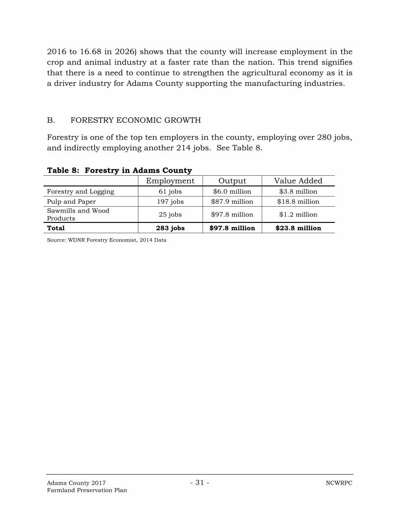
B. FORESTRY ECONOMIC GROWTH
Forestry is one of the top ten employers in the county, employing over 280 jobs, and indirectly employing another 214 jobs. See Table 8.
Table 8: Forestry in Adams County Employment Output Value Added
Forestry and Logging 61 jobs $6.0 million $3.8 million
Pulp and Paper 197 jobs $87.9 million $18.8 million Sawmills and Wood Products
25 jobs $97.8 million $1.2 million
Total 283 jobs $97.8 million $23.8 million
Source: WDNR Forestry Economist, 2014 Data

Adams County 2017 - 32 - NCWRPC Farmland Preservation Plan
CHAPTER 6 GOALS, OBJECTIVES, POLICIES, AND MAPPING CRITERIA A. GOALS, OBJECTIVES, AND POLICIES
Most communities within Adams County went through the comprehensive planning process in 2004-2005. Housing demand was projected during that process, and residents identified where additional housing would be located. These areas can be seen on the Future Land Use map. Residents identified why new residents would move into their communities, and recognized that future housing development would take a variety of forms. Many of those local comprehensive plans are being updated in 2016 and 2017. See Chapter 7, under: “PLAN AMENDMENTS AND CONSISTENCY” for details about how this plan can be modified as local comprehensive plans are created. No additional housing related goals, objectives, and policies were identified from what already exists in the Adams County Comprehensive Plan, because of the housing trends identified.
Goal: Promote Working Forests and Farms.
Objectives:
1. Minimize the conversion of agricultural lands and woodlands into other uses.
2. Encourage retaining large, contiguous, forestry and farmland tracts.
3. Work to preserve farming and forestry as viable occupations within in County.
4. Avoid creating land use conflicts through proper land use planning.
Policies: 1. Promote farmland preservation programs from all levels of government.
2. Promote agricultural cost share programs to farmers per the Adams County Land & Water Resource Management Plan.
3. Promote DATCP’s Farmland Preservation programs to farmland owners.
4. Promote DNR’s Managed Forest Law participation to forestland owners.
Adams County 2017 - 33 - NCWRPC Farmland Preservation Plan
5. Encourage residential development away from agricultural areas through appropriate land use planning.
6. Encourage expanding agricultural development away from residential areas through appropriate land use planning.
7. Promote rural cluster development for housing that seeks to locate in forested or agricultural areas.
8. Non-farm development, particularly subdivisions, will be encouraged in areas away from intensive agricultural activities, in order to minimize farm and non-farm conflicts due to noise, odors, nitrates in well water, pesticides, farm/vehicle conflicts on roadways, late night plowing, etc.
9. Encourage the development of a website with more farmland preservation information.
B. MAPPING CRITERIA The Farmland Preservation Area is mapped in order to include as many potential participants as possible, while taking into consideration the 15-year future growth of the County. Since mapping criteria is partially based upon the County’s Future Land Use map, and since local governments are updating their comprehensive plans (and Future Land Use maps) in 2016 and 2017, then this Farmland Preservation Plan map (Map 7, and Attachment A maps) will need updating after those local plans are adopted. See Chapter 7, under: “PLAN AMENDMENTS AND CONSISTENCY” for more details. The Adams County Farmland Preservation Plan Map (Map 7, and Attachment A maps) identifies: “Farmland Preservation Areas,” and “Planned Out” areas. Farmland preservation areas were determined by including the following future land uses (Map 6): agriculture, forestry, or preservation and open space; and all lands zoned for agriculture (A-1 and A1-15). So if a parcel is either zoned for agriculture or is identified on Map 6 as: ag., forestry, or preservation & open space, then the parcel is “in” so the landowner can participate in farmland preservation. The next step was determining what land to exclude. Basically, all land that is planned for development over the next 10-15 years was removed from farmland preservation, because non-agriculture is planned. See the Mapping Criteria. When creating the Farmland Preservation Plan Map (Map 7, and Attachment A maps) there was an anomaly that created small parcels. An oil pipeline is that

Adams County 2017 - 34 - NCWRPC Farmland Preservation Plan
anomaly, which crosses all of Adams County from northwest to southeast. Many parcels were divided by this pipeline, and smaller parcels were created. If a large parcel was determined to be “in” farmland preservation due to the mapping criteria, then any smaller parcels with the same tax id number along this pipeline were also considered “in.” Below are the map legend definitions:
Farmland Preservation Areas – Parcels that meet the Farmland Preservation Plan mapping criteria. Landowners in this area may apply for farmland preservation income tax credits, if the town has adopted County zoning. In an un-zoned town, the residents may apply for an Agricultural Enterprise Area if they meet the criteria. These areas have been identified during the planning process to be agricultural uses or open spaces. No non-agricultural development is planned in the next fifteen years for those areas identified as farmland preservation areas.
In addition, if there is a conflict with other plan maps, the Farmland Preservation Plan map (Map 7, and Attachment A maps) will supersede those other maps. Planned Out – Parcels that do not allow the owner to apply for farmland preservation income tax credits. These parcels are “planned out,” or excluded because they meet the criteria for non-farmland preservation areas.
Criteria for Farmland Preservation Areas:
Lands depicted on the Future Land Use Map as agriculture, forestry, or preservation and open space.
Lands zoned A1 or A1-15.
Criteria for Non-Farmland Preservation Areas
Exclude all of the following:
Any platted subdivisions.
Any parcel less than 15 acres.
Parcels that are surrounded by land ineligible for farmland preservation.
Any non-taxable land.
The Towns of Big Flats, Easton, Jackson, Lincoln, Rome, and Springville took legislative action to “opt-out” of Farmland Preservation.

Adams County 2017 - 35 - NCWRPC Farmland Preservation Plan
CHAPTER 7 IMPLEMENTATION This chapter identifies common tools available to assist landowners with preserving their farmland for future generations of productivity. Also included is a section about how to revise the plan when conditions change, and so that this plan remains consistent with the Adams County Comprehensive Plan.
A. IMPLEMENTATION TOOLS
Educating the public and local government agencies about the economic benefits of farming and the cost of converting farmland to non-agricultural use is an important part of the implementation strategy. Equally important is showing that land stewardship benefits the owner financially, while also protecting soil productivity into the future. The Wisconsin Working Lands Initiative was signed into law in 2009 and is comprised of the following programs:
Farmland Preservation Plan (FPP); Farmland Preservation Zoning (FP Zoning); Agricultural Enterprise Area (AEA) Program; and Purchase of Agricultural Conservation Easement (PACE) Program [not
funded]
Here is a brief description of each of these tools: Farmland Preservation Plan (FPP) A Working Lands Initiative program
This document is locally created to determine where to encourage farmers to keep their land in productive farming. Lands mapped locally for preservation cannot be planned for development over the next 15 years. Individual farms may not be selectively added or removed; that is what the Mapping Criteria in this plan are for. Establishing this plan is required by law (§91.10(3) Wis. Stats.). The rest of the tools are optional to create.

Adams County 2017 - 36 - NCWRPC Farmland Preservation Plan
Identifying lands for preservation in this plan is the basis for who can participate in the rest of the Working Lands Initiative programs (i.e. FP Zoning, AEA Program, & PACE Program). Farmland Preservation Zoning (FP Zoning) A Working Lands Initiative program
This is the next optional step for Adams County, or locally zoned towns, to consider taking after the Farmland Preservation Plan is adopted in order for residents to actually claim tax credits, unless an AEA (see definition) comes to Adams County. Farmland Preservation Zoning (FP Zoning), which needs to be certified by DATCP, allows some residential development but can restrict housing density. Such constraints on development potential can limit land speculation and keep land affordable to farmers. Keeping large areas relatively free of non-farm development can reduce the likelihood of conflicts between farmers and their non-farming neighbors. If FP Zoning is enacted, then eligible farmers in a FP Zoning district may annually apply for $7.50/acre state tax credits. See DATCP’s Farmland Preservation Tax Credits fact sheet in Attachment D. Agricultural Enterprise Areas (AEA) A Working Lands Initiative program
This is an optional tool that can help communities meet locally identified goals for preserving agricultural land and encouraging agricultural economic development. An AEA is an area of contiguous land primarily in agricultural use that has been designated by DATCP in response to a locally developed petition. Designation of an AEA identifies the area as valuable for current and future agricultural use. Eligible farmers in an AEA can receive income tax credits per an agreement with DATCP. General eligibility requirements are:
Five eligible land owner participants;

Adams County 2017 - 37 - NCWRPC Farmland Preservation Plan
All land in the proposed AEA area must be in the farmland preservation area;
Land must be contiguous; and Land must be primarily in agricultural use.
Benefits of the AEA designation are that the land is identified as important for agricultural preservation. This designation provides reassurance about future farmland use and may encourage investment in agriculture. Eligible landowners can enter into a voluntary Farmland Preservation Agreement that allows them to claim a tax credit in exchange for keeping land in agricultural use for 15 years and meeting conservation standards. Tax credits are as follows:
$10.00/acre if land is FP Zoned, located in an Agricultural Enterprise Area, and landowner has a Farmland Preservation Agreement with DATCP signed after 2009.
$5.00/acre if landowner has a Farmland Preservation Agreement with DATCP signed after 2009.
See DATCP’s Farmland Preservation Tax Credits fact sheet in Attachment D. Purchase of Agricultural Conservation Easements (PACE Program) A Working Lands Initiative program, which is not funded as of 2016.
Agricultural Conservation Easements are deed restrictions that landowners voluntarily place on their properties to protect productive agricultural land. They sell a conservation easement to a government agency or private conservation organization. Landowners retain full ownership and continue to pay property taxes, and manage and operate the farm. Conservation easements are tailored to each property: purchasers and landowners decide which activities should be restricted or limited. When the landowner eventually sells the farmland, the development restrictions are passed on to the new owner.
Adams County 2017 - 38 - NCWRPC Farmland Preservation Plan
Other land use tools that may be implemented to preserve farmland: Purchase of Development Rights (PDR) – Purchase of Development Rights (PDR) is an incentive based, voluntary program with the intent of permanently protecting productive, sensitive, or aesthetic landscapes, yet retaining private ownership and management. In this program, a landowner sells the development rights of a parcel of land to a public agency, land trust or unit of government. A conservation easement is recorded on the title of the property that limits development permanently. Comprehensive Land Use Planning – A comprehensive plan is a local government's guide to a community’s physical, social, and economic development. Comprehensive plans are not meant to serve as land use regulations in themselves; instead, they provide a rational basis for local land use decisions with a twenty-year vision for future planning and community decisions. The County and Townships can use their comprehensive plans (§66.1001 Wis. Stats.) as the basis for farmland preservation zoning ordinances. This not only protects these areas for agricultural uses but also offers a greater tax incentive for landowners.
B. MONITORING
Monitoring is an important step to the whole planning process in order to assess what is working and needs to be adjusted. The County will continually evaluate that decisions remain consistent with goals and objectives of the Farmland Preservation Plan and the County’s Comprehensive Plan. Any participants in the programs will be monitored according to rules and regulations set forth by the Federal, State or Local agencies participating in the program. C. PLAN CONSISTENCY AND AMENDMENTS This Farmland Preservation Plan fulfills the statutory requirements for both the Farmland Preservation Plan (Chapter 91, Subchapter II, WI Statutes) and the Agricultural Element of the Comprehensive Plan (§66.1001(2), Wis. Stats.).

Adams County 2017 - 39 - NCWRPC Farmland Preservation Plan
Several methods were used to ensure consistency between this Farmland Preservation Plan and the Adams County Comprehensive Plan.
1. The Farmland Preservation Plan was adopted as an attachment to the Comprehensive Plan.
2. Goals, objectives, and policies initially came from the Comprehensive Plan, then were modified to focus on farmland preservation, while still complementing the Comprehensive Plan’s goals, objectives, and policies.
3. All maps came from, or are consistent with, the Comprehensive Plan.
4. Mapping criteria used the Future Land Use Map from the Comprehensive Plan.
Now that the Farmland Preservation Plan is part of the Comprehensive Plan, Wisconsin Statute §66.1001 requires that an adopted plan be reviewed and updated at least once every ten years. This is not a static plan, but one that may change over time. Changing land uses, policy changes, regulatory changes, or shifting economics are some reasons to review if this plan is still current. Most communities within Adams County went through the comprehensive planning process in 2005-2006. As communities update their Comprehensive Plans, they are also updating their Future Land Use maps within those plans. All of these local Future Land Use maps will be included in the County Comprehensive Plan, probably on an annual basis. It is the Planning & Zoning Department’s policy to maintain the County’s Future Land Use map as a quilt of local government’s Future Land Use maps. The Adams County Planning & Zoning Committee will decide how often to update the Adams County Comprehensive Plan to include local government’s Future Land Use maps, and subsequently update the Farmland Preservation Maps (Map 7, and Attachment A maps). The Future Land Use map will need to change as local governments update their Comprehensive Plans, and due to the mapping criteria using this map, the Farmland Preservation Plan Map will also need to change. The process to amend the Plan is similar to that of writing this initial document. The steps to amend any part of the Plan will be as follows:

Adams County 2017 - 40 - NCWRPC Farmland Preservation Plan
1. As the result of a request from a local government, a property owner, a developer, or the County Planning & Zoning Committee (Committee) itself, the County staff and Committee will evaluate the proposed amendment to see if its meets the goals and objectives of the Plan, the State requirements, and any other laws or standards that may be in effect at the time of the request.
2. The County staff prepares the text and/or map that amend the specific part of the Farmland Preservation Plan or Plan map.
3. The Committee adopts a resolution outlining the proposed amendment.
4. County staff forward the amended materials required under Section 91.20, Wis. Stats., to DATCP for certification of the Plan amendment.
5. A Class 1 notice is published at least 30 days before the County Board public hearing is held.
6. The County Board holds the formal public hearing on an ordinance that would incorporate the proposed Plan amendment into the County’s Farmland Preservation Plan.
7. Following the public hearing and DATCP certification, the County Board approves or denies the ordinance adopting the proposed Plan amendment.
8. County staff forwards a copy of the adopted ordinance and Plan amendment to DATCP and any landowners who have requested a copy in writing as well as Township chairpersons.

Adams County 2017 - 41 - NCWRPC Farmland Preservation Plan
Map 1 Existing Land Use

Adams County 2017 - 42 - NCWRPC Farmland Preservation Plan
Map 2 Natural Resources

Adams County 2017 - 43 - NCWRPC Farmland Preservation Plan
Map 3 Soils

Adams County 2017 - 44 - NCWRPC Farmland Preservation Plan
Map 4 Cropland Data

Adams County 2017 - 45 - NCWRPC Farmland Preservation Plan
Map 5 Ownership

Adams County 2017 - 46 - NCWRPC Farmland Preservation Plan
Map 6 Future Land Use

Adams County 2017 - 47 - NCWRPC Farmland Preservation Plan
Map 7 County Farmland Preservation

ATTACHMENT A
Town Farmland Preservation Maps

ATTACHMENT B
Public Participation Plan and Resolution

ATTACHMENT C
Farmland Preservation Plan Resolution and Ordinance
ATTACHMENT D
Farmland Preservation Flowchart and
DATCP Tax Credit Fact Sheet