ACT Second Electricity Supply - Switching Station and 330 ... · 23/13367/58928 ACT Second...
47
TransGrid ACT Second Electricity Supply - Switching Station and 330 kV Electricity Transmission Line Options Assessment August 2010
-
Upload
truongdung -
Category
Documents
-
view
217 -
download
0
Transcript of ACT Second Electricity Supply - Switching Station and 330 ... · 23/13367/58928 ACT Second...

TransGrid
ACT Second Electricity Supply -Switching Station and 330 kVElectricity Transmission Line
Options Assessment
August 2010

i23/13367/58928 ACT Second Electricity Supply - Switching Station and 330 kV Electricity Transmission LineOptions Assessment
Contents
1. Introduction 1
1.1 Overview 1
1.2 Certainty Level 1
2. Project Background 3
2.1 Project Background 3
2.2 Project Outline 4
2.3 Project Requirements 4
3. Study Area 5
3.1 Definition of Study Area 5
3.2 Statutory Planning Provisions 5
3.3 Land-use Conflicts 7
3.4 Contaminated Land 8
3.5 Heritage 8
3.6 Topography and ground conditions 9
3.7 Surface Water 9
3.8 Flora and Fauna 10
3.9 Bushfire Hazard 12
3.10 Visual Characteristics 12
3.11 EMF and Electrical Interference 13
4. Options Assessment 15
4.1 Overview 15
5. Option 1 Assessment 16
5.1 Switching Station Option 1 16
5.2 Route Option 1A 16
5.3 Route Option 1B 18
5.4 Route Option 1C 18
5.5 Environmental Constraints 18
6. Option 2 Assessment 21
6.1 Switching Station Option 2 21
6.2 Route Option 2A 21
6.3 Route Option 2B 21

ii23/13367/58928 ACT Second Electricity Supply - Switching Station and 330 kV Electricity Transmission LineOptions Assessment
6.4 Environmental Constraints 23
7. Option 3 Assessment 25
7.1 Switching Station Option 3 25
7.2 Route Option 3A 25
7.3 Environmental Constraints 25
8. Option 4 Assessment 29
8.1 Switching Station Option 4 29
8.2 Route Option 4A 29
8.3 Environmental Constraints 29
9. Option 5 Assessment 32
9.1 Switching Station Option 5 32
9.2 Route Option 5A 32
9.3 Environmental Constraints 32
10. Crossing 2 36
10.1 Environmental Constraints 36
11. Comparative analysis 37
11.1 Comparative ranking of options 37
12. Recommendation 40
13. References 41
Table IndexTable 3-1 NH&MRC Limits of Exposure 14Table 5-1 Option 1 Environmental Constraints 18Table 6-1 Option 2 Environmental Constraints 23Table 7-1 Option 3 Environmental Constraints 27Table 8-1 Option 4 Environmental Constraints 31Table 9-1 Option 5 Environmental Constraints 34Table 10-1 Crossing 2 Environmental Constraints 36Table 11-1 Switching Station comparative ratings 37Table 11-2 Line route options comparative ratings 38Table 11-3 Crossing options comparative ratings 38Table 11-4 Total Preferred Option Comparative Analysis 39

iii23/13367/58928 ACT Second Electricity Supply - Switching Station and 330 kV Electricity Transmission LineOptions Assessment
Figure IndexFigure 1-1 Options for Switching Station and Line Routes 2Figure 3-1 Registered Areas of Nominated or Provisional Heritage. 9Figure 5-1 Switching Station Option 1 and Line Routes 17Figure 6-1 Switching Station Option 2 and Line Routes 22Figure 7-1 Switching Station Option 3 and Line Routes 26Figure 8-1 Switching Station Option 4 and Line Routes 30Figure 9-1 Switching Station Option 5 and Line Routes 33

iv23/13367/58928 ACT Second Electricity Supply - Switching Station and 330 kV Electricity Transmission LineOptions Assessment
Abbreviations
ACT Australian Capital Territory
AHIMS Aboriginal Heritage Information Management System
EI Electrical interference
EMFs Electric and magnetic fields
EP&A Act Environmental Planning and Assessment Act 1979
EPBC Act Environmental Protection and Biodiversity Conservation Act 1999
ESSA Electricity Supply Association Australia
ETL Electricity Transmission Line
kV Kilovolt
km Kilometres
kV/m Kilovolts per metre
MCMA Murrumbidgee Catchment Management Authority
mG MilliGauss
NHMRC National Health and Medical Research Council
NSW New South Wales
TaMS Territory and Municipal Services
TSC Act Threatened Species Conservation Act 1995
YVC Yass Valley Council
123/13367/58928 ACT Second Electricity Supply - Switching Station and 330 kV Electricity Transmission LineOptions Assessment
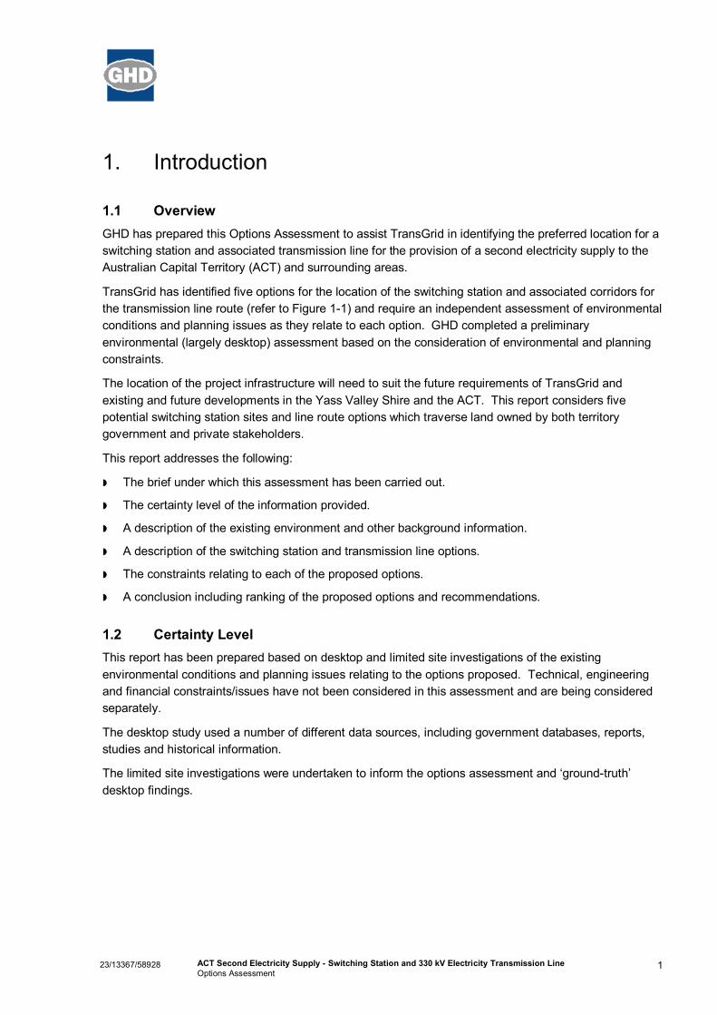
1. Introduction
1.1 OverviewGHD has prepared this Options Assessment to assist TransGrid in identifying the preferred location for aswitching station and associated transmission line for the provision of a second electricity supply to theAustralian Capital Territory (ACT) and surrounding areas.
TransGrid has identified five options for the location of the switching station and associated corridors forthe transmission line route (refer to Figure 1-1) and require an independent assessment of environmentalconditions and planning issues as they relate to each option. GHD completed a preliminaryenvironmental (largely desktop) assessment based on the consideration of environmental and planningconstraints.
The location of the project infrastructure will need to suit the future requirements of TransGrid andexisting and future developments in the Yass Valley Shire and the ACT. This report considers fivepotential switching station sites and line route options which traverse land owned by both territorygovernment and private stakeholders.
This report addresses the following:
» The brief under which this assessment has been carried out.
» The certainty level of the information provided.
» A description of the existing environment and other background information.
» A description of the switching station and transmission line options.
» The constraints relating to each of the proposed options.
» A conclusion including ranking of the proposed options and recommendations.
1.2 Certainty LevelThis report has been prepared based on desktop and limited site investigations of the existingenvironmental conditions and planning issues relating to the options proposed. Technical, engineeringand financial constraints/issues have not been considered in this assessment and are being consideredseparately.
The desktop study used a number of different data sources, including government databases, reports,studies and historical information.
The limited site investigations were undertaken to inform the options assessment and ‘ground-truth’desktop findings.

Option 3
5A
5A
Parkwood Road
(Study area)
1B
1A
2B
2A
Parkw
ood Road
Option 2
Option 1
Option 5
Option 4
1C
4A (green)
3A(blue)
ETL Crossings
Existing residences
Canberra Nature Reserve
AHIMS registered site
Crossing 4Crossing 3
Crossing 2
Crossing 1

323/13367/58928 ACT Second Electricity Supply - Switching Station and 330 kV Electricity Transmission LineOptions Assessment
2. Project Background
2.1 Project BackgroundThe ACT jurisdiction’s reliability criteria requires TransGrid to establish a second supply point for theACT, and to provide a 330 kV supply independent of the Canberra 330/132 kV substation to that supplypoint.
The ACT and surrounding areas are currently supplied by a 132 kV transmission network emanatingfrom the Canberra 330/132 kV Substation. The Canberra 330/132 kV substation, while having adequatetransformer capacity, is poorly located to efficiently supply newly identified urban growth areas to thesouth east of Canberra. In addition, the ACT jurisdiction has promulgated reliability criteria requiringTransGrid to make available geographically separate 132 kV connection point that provides specificcapacity to the ACT jurisdiction.
The purpose of this project is to provide increased reliability of supply to the ACT in the event of thecatastrophic loss of Canberra 330/132 kV substation. The switching station should be located at a‘reasonable distance’ from the existing Canberra 330/132 kV Substation such that no single catastrophicevent can disable both sites. This would ensure that the supply into the ACT would be maintained in theevent of any one site being damaged.
Establishment of the second supply point has been initiated and a new Substation at Williamsdale isscheduled for completion by 1 July 2011. In order to supply Williamsdale independently from theCanberra 330/132 kV Substation, TransGrid’s Project Feasibility Study Report (FS PSR 148 Rev 0)investigated two specific options for the establishment of a second supply point:
» Option 1: Establishment of a switching station in the Uriarra area approximately three to fourkilometres from the existing Canberra 330/132 kV. This would include:
– The development of a 330 kV switching station.
– The cutting-in of the existing Canberra–Yass 330 kV transmission line (Yass transmission line) tothe new switching station.
– The construction of a single circuit 330 kV line approximately three to four kilometres in length toconnect to the Canberra–Williamsdale 330 kV transmission line (Williamsdale transmission line).
» Option 2: Supplying Williamsdale directly from Yass instead of Canberra. This requires either:
– Constructing a new single circuit 330 kV transmission line between Yass and the Williamsdaletransmission line. The new line would be constructed adjacent to the existing Yass transmissionline and be approximately 50 km in length.
– The provision of an additional 330 kV linebay at Yass 330/132 kV substation.
OR
– Dismantling the existing Yass transmission line and constructing a double circuit 330 kV linebetween Yass and Canberra. One circuit would be connected to Canberra substation and theother connected outside of Canberra to form a Yass–Williamsdale 330 kV line.
– The provision of an additional 330 kV linebay at Yass 330/132 kV substation.

423/13367/58928 ACT Second Electricity Supply - Switching Station and 330 kV Electricity Transmission LineOptions Assessment
Based on this study and preliminary investigations, it was recommended that Option 1 be implemented.As such, a new section of single circuit 330 kV transmission line is required to connect the Canberra toWilliamsdale 330 kV transmission line to the proposed new switching station. The new switching stationwould be cut into the Canberra to Yass 330 kV transmission line.
During initial stakeholder and property owner consultation, 17 different configurations under Options 1 &2 were presented to TransGrid for consideration. TransGrid has reduced these options to five by virtue ofinitial consideration of the ACT jurisdiction reliability criteria, regulatory requirements, theabovementioned project feasibility study report as well as technical, environmental financial constraints.The remaining five options are currently being considered by TransGrid.
This Environmental Options Assessment provides independent assessment of environmental conditionsand planning issues as they relate to each of these five options. As such, the assessment will assistTransGrid in identifying the preferred location for a switching station and associated transmission line forthe provision of a second electricity supply to the ACT and surrounding areas.
2.2 Project OutlineTo facilitate the proposed works, TransGrid are required to undertake site and route selection for:
» Establishment of a new 330 kV switching station.
» Establishment of a new 330 kV single circuit electricity transmission line (ETL) to connect the Yasstransmission line to the Williamsdale transmission line.
2.3 Project RequirementsTransGrid provided the following project requirements for consideration during site and route selection:
» The immediate and future electricity needs of the population of the ACT and surrounding areas mustbe met.
» A separate supply of electricity to that provided by the Canberra 330/132 kV substation must beprovided. This separate supply of electricity should be located at a ‘reasonable distance’ from theexisting substation such that no single catastrophic event can disable both sites.
» The potential environmental impacts of the proposed works are minimised.
» The crossings of the Upper and Lower Tumut transmission lines must be located at one of the fourdesignated ETL crossing locations (identified in Figure 1-1). Although none of the proposed lineroutes cross at the point identified as ‘Crossing 2’, this option was considered as part of thisassessment.
» Connection of the proposed ETL to the Williamsdale transmission line is feasible at all locationssouth of the Canberra 330/132 kV Substation (identified as towers 2 to 7).
» Any new 330 kV easements are required to be 60 metres wide.

523/13367/58928 ACT Second Electricity Supply - Switching Station and 330 kV Electricity Transmission LineOptions Assessment
3. Study Area
3.1 Definition of Study AreaThe study area is located approximately 14 kilometres to the north-west of the centre of Canberra on theNew South Wales (NSW)/Australian Capital Territory (ACT) border. The following description of thestudy area relates mostly to the land within the property holdings identified as 001, 002, 003, 004 and005 in Figure 1-1. This area encompasses the five options for the location of the switching station andelectricity transmission lines, and is hereafter referred to as the ‘study area’.
3.2 Statutory Planning ProvisionsThere are a number of statutory planning provisions in which any of the proposed options will enact. Forexample, cross jurisdiction planning and coordination will occur as the proposed development mayinvolve the crossing of the ACT/ NSW boarder.
3.2.1 NSW Legislation
Environmental Planning and Assessment Act 1979The provisions of the Environmental Planning and Assessment Act 1979 (EP&A Act) governdevelopment within the State of NSW. The path for assessment and determination of a development isdependent on which Part of the Act applies, i.e.:
» Part 3A – applies to all developments declared to be a Major Project in accordance with section 75Bof the EP&A Act, and where approval is required from the Minister.
» Part 4 – applies where development consent is required from a consent authority.
» Part 5 – applies where development consent is not required and a determination to approve theactivity is made by a determining authority.
As the Proposal is being undertaken by a Public Authority and falls under the definition of “electricitytransmission and distribution network” it is considered “development permitted without consent” pursuantto clause 41 of the State Environmental Planning Policy (Infrastructure) 2007 (refer below). The Proposalwould therefore normally be determined under Part 5 of the EP&A Act with TransGrid being thedetermining authority. However, if the Proposal is deemed likely to significantly affect the environment,as determined by the environmental impact assessment, Part 3A (Major Infrastructure and otherProjects) of the EP&A Act would apply by virtue of section 75B of the EP&A Act, i.e.:
79B Projects to which Part [3A] applies….
(2) Kinds of projects. The following kind of development may be declared to be a project to whichthis Part applies:
(a) major infrastructure or other development that, in the opinion of the Minister, is of State orregional environmental planning significance,
(b) major infrastructure or other development that is an activity for which the proponent is also thedetermining authority (within the meaning of Part 5) and that, in the opinion of the proponent,would (but for this Part) require an environmental impact statement to be obtained under that Part.

623/13367/58928 ACT Second Electricity Supply - Switching Station and 330 kV Electricity Transmission LineOptions Assessment
Therefore if the proposed development is deemed likely to significantly affect the environment, thedevelopment would be determined through Part 3A of the Act and the Minister for Planning would be thedetermining authority.
State Environmental Planning Policy (Infrastructure) 2007 (SEPP)Pursuant to Clause 41(1) of the SEPP, development for the purpose of an electricity transmission ordistribution network may be carried out by or on behalf of an electricity supply authority or public authoritywithout consent on any land.
Clause 41(2) refers to development in connection with such a network that is also permitted withoutconsent, including:
“(a) construction works (whether or not in a heritage conservation area), including:
(i) laying and installation of cables and cable pits, co-location of cabling and erection ofventilation and access structures, bridges and tunnel edits, and construction of atunnel or conduit for an underground cable, and
(ii) alteration, demolition or relocation of a local heritage item, and
(iii) alteration or relocation of a State heritage item,
(b) emergency works, or routine maintenance works, on the site of an existing component of anetwork or on land that is adjacent to such a site (whether or not the works are on land towhich State Environmental Planning Policy No 14—Coastal Wetlands or StateEnvironmental Planning Policy No 26—Littoral Rainforests applies but, if they are on suchland, only if any adverse effect on the land is restricted to the minimum possible to allow theworks to be carried out),
(c) environmental management works,
(d) establishment of a new substation or an increase in the area of existing substation yards orthe installation of equipment, plant or structures in existing substation yards or substationbuildings,
(e) above or below ground co-location of telecommunications cabling and associatedstructures,
(f) an electricity generating unit to provide temporary support to the network at a substation ormaintenance depot, but only if the combined capacity of all units at the substation ormaintenance depot does not exceed 5 megawatts and none of the units is operated, or isintended to be operated, for more than 200 hours in any 12 month period.”
As the proposed works fall within the definition of works permissible without consent under this SEPP,there would be no requirement to obtain development consent and hence Part 5 of the EP&A Actapplies.
As the proposed works involve the construction of a new switching station and transmission line, and arebeing undertaken by TransGrid, a public authority, they are deemed to be covered by the SEPP.Pursuant to clause 8 of the SEPP, the SEPP prevails to the extent of any inconsistency with the relevantLEPs, and as such development consent is not required.

723/13367/58928 ACT Second Electricity Supply - Switching Station and 330 kV Electricity Transmission LineOptions Assessment
ACT LegislationLegislation within the ACT includes:
» Planning and Development Act 2007
» The Territory Plan 2008
As the proposed development involves the construction of a 330 kV ETL, Schedule 4 of the Planning andDevelopment Act 2007 applies to all of the proposed options. Accordingly, the proposed developmentwould be assessed under the Impact Track process, irrespective of which switching station option andassociated route is selected.
The proposed development has been specified under Schedule 4 of the Planning and Development Act2007 and is not listed as prohibited development under the Code:
“proposal for electricity generation works or distribution corridor, including a proposal including allor any of the following:
(a) transmission line corridor construction, or realignment works, outside an existing corridor thatare intended to carry transmission lines with a voltage of 132 kV or more;”
Under the Territory Plan 2008, a Major Utility Installation is permissible under the Non-Urban ZonesDevelopment Code for all of the following zonings impacted by the proposed options:
» Non-Urban – NUZ1 – Broadacre
» Non-Urban – NUZ3 – Hills, Ridges and Buffers
» Non-Urban – NUZ4 – River Corridor
3.3 Land-use ConflictsThe proposed development is located on the outer fringe of Canberra. There are a number of bothpotential and actual land use conflicts which may occur, depending on the option selected. Anassessment of the proposed development options with regards to future and current land-use conflicts isprovided below. This includes consideration of a 500 metre development restriction zone around theWest Belconnen Landfill.
Through stakeholder consultation and liaison, TransGrid has been made aware of proposed residentialdevelopment areas (particularly within Property Holdings 001 and 003, as detailed in Figure 1-1).However, the proposed development areas are indicative only and are currently subject to Non –Urban –NUZ1 – Broadacre, Non –Urban – NUZ2 – Rural and Non – Urban – NUZ4 – River Corridor land usezoning and do not form part of any formal planning document. Despite this, these proposed residentialdevelopment areas have still been taken into consideration during this Options Assessment.
Switching Station Option 1 is located in grazing land in NSW and consists of three line routes to the westof the West Belconnen Land Fill and to the east of the Murrumbidgee River. Line routes B and C coverpredominately the Non – Urban – NUZ4 – River Corridor zoning, whereas route A crosses the Non –Urban – NUZ1 – Broadacre and Non- Urban – NUZ3 – Hills, Ridges and Buffers zonings. Whilst theproposed development is permissible within all of these zonings, there is a potential land use conflictbetween line A and the existing West Belconnen Landfill due to its proximity.

823/13367/58928 ACT Second Electricity Supply - Switching Station and 330 kV Electricity Transmission LineOptions Assessment
Switching Station Option 2 is also located in grazing land in NSW. It has two potential line route options.Route B is proposed to run parallel to the Murrumbidgee River Corridor to the west, with route A to theeast and through the existing West Belconnen Landfill. It is evident that route A has the potential tocause some land use conflict given its proximity to the development restriction zone of the landfill whilstroute B extends further into the River Corridor.
Switching Station Option 3 is located directly adjacent to the West Belconnen Landfill with the line routepassing through Non –Urban – NUZ1 – Broadacre and Non- Urban – NUZ3 – Hills, Ridges and Bufferszonings. This option has the potential to cause significant land use conflict as both the switching stationand line route are situated within the development restriction zone.
Switching Station Options 4 and 5 are both within the development restriction zone and the physicalperimeters of the West Belconnen Landfill. Hence, there is the potential for significant land use conflict,as well as subsidence risks. In the case of Option 5, a row of vegetation which is currently acting as avisual buffer, may need to be removed to accommodate the project infrastructure.
3.4 Contaminated LandA number of contaminated land issues have been identified in the ACT portion of the study area,including the West Belconnen Landfill Site operated by ACT NOWaste (a disposal site for AsbestosContaminated Material), and Parkwood Road Recycling Estate. Given the known land uses currentlyexisting on site, it is considered highly likely that these properties would be subject to significantcontamination issues. A register of potential sheep dips in the ACT was reviewed; however, none wererecorded in the study area.
A review of the list of confirmed and potential contaminated sites within the Yass Valley LGA indicatedthat there were no contaminated land issues in relation to the NSW section of the study area (DECCW2010a).
3.5 HeritageWithin the ACT, Block 1586 (Property Holding 002 as depicted in Figure 1-1) has been designated as anominated or provisional Registration Area (refer to Figure 3-1), as part of the Block is associated withAboriginal remains (TaMS 2009). The heritage significance of residential dwellings immediately to theeast of Block 1586 is unknown.
A search of Aboriginal and cultural heritage in NSW indicated that a number of known heritage locationsexist including at Hall, Murrumbateman, Yass, Binalong, Burrinjuck and Collector. These are not withinthe study area, and would therefore not be influenced by the proposed works. These include a nationalheritage place, Oak Hill Reserve, Ginninderra Falls Area and the Parkwood Homestead and Chapel(DEWHA 2010).
An Aboriginal Heritage Information Management System (AHIMS) search request from the Departmentof Environment, Climate Change and Water (DECCW) revealed that there are 18 Aboriginal objects andplaces recorded in the north of the study area within NSW (refer to Figure 1-1).

923/13367/58928 ACT Second Electricity Supply - Switching Station and 330 kV Electricity Transmission LineOptions Assessment
Figure 3-1 Registered Areas of Nominated or Provisional Heritage.
Source: TaMs 2010.
3.6 Topography and ground conditionsThe study area is located within the upper reaches of the Murrumbidgee Catchment, which extends fromthe Kosciusko National Park to the confluence with the Murray River near Balranald (MCMA 2008).Elevation within the study area is approximately 540 metres above sea level, and is undulating withminor ridges and significant fall from the west of the area to the Murrumbidgee River.
The local geology is the Mount Painter Volcanics and is of Silurian and Devonian age (GeoscienceAustralia 1966).
Local soils consist of a variety of mixtures of sand, loam, silt and clay. Red and yellow podzolics arenoted to be low fertility soil types, which affect agriculture (YVC 2004). Soil erosion hazard ranges fromslight to very high, with higher soil erosion hazard noted in the north and north-east of the study area(DECCW 2009b).
3.7 Surface WaterThe Murrumbidgee River is the dominant source of freshwater in the area, and is associated with deepgullying. The nearest of the proposed options is located approximately one kilometre to the east of theriver. Ginninderra Creek is also located less than one kilometre from switching station option 2.

1023/13367/58928 ACT Second Electricity Supply - Switching Station and 330 kV Electricity Transmission LineOptions Assessment
The Murrumbidgee River, and its associated tributaries, have been extensively cleared and settled,resulting in the exploitation of groundwater and surface water resources. These activities have, and stillare, having an impact upon water quality (YVC 2004). Potential threats to the water quality of theMurrumbidgee River and Ginninderra Creek include nutrient pollution and sedimentation, resultingprimarily from land clearing, agriculture, grazing and discharges into streams at point sources (YVC2007). Urban salinity is also an issue in the Murrumbidgee Catchment, which has resulted in saltaccumulation at or near the surface which leads to degradation and die-off of vegetation (MCMA 2010).
The study site is unlikely to be significantly affected by flood waters due to the distance from the nearestwaterways, and the deep gullies associated with these waterways.
3.8 Flora and FaunaThe study area is part of the South Eastern Highlands Biogeographic Region (bioregion). The SouthEastern Highlands Bioregion lies just inland from the coastal bioregions of the South East Corner and theSydney Basin, bounded by the Australian Alps and South Western Slopes bioregions to the south andwest. The bioregion includes most of the ACT and extends south into Victoria (DECCW 2008c).
The South Eastern Highlands Bioregion lies just inland from the coastal bioregions of the South EastCorner and the Sydney Basin, bounded by the Australian Alps and South Western Slopes bioregions tothe south and west. The bioregion includes most of the ACT and extends south into Victoria. Both soilsand vegetation vary across the bioregion in relation to altitude, temperature and rainfall. The Bioregioncontains a range of vegetation communities including naturally treeless environments, woodlands and tallforests. The flora and fauna of the South Eastern Highlands is diverse and includes many threatenedspecies. The threatened flora and fauna known to occur in the South Eastern Highlands occupy many ofthe habitats present across the region including those found in the locality (NPWS, 2003).
GHD conducted a flora and fauna survey in December 2009 to assess the likely impacts of switchingstation Option 1 and transmission line route 1C. Large areas of the current study area were coveredduring the December survey. The December survey identified approximately 100 flora species including54 natives. The 46 exotic species did however make up a large groundcover component with Wild Oats(Avena barbata), Great Brome (Bromus diandrus), Wall Fescue (Vulpia muralis), Saffron Thistle(Carthamus lanatus), Soft Brome (Bromus hordeaceus) and Narrow-leaved Clover (Trifoliumangustifolium) common across the site.
The study area for the previous survey included two Mitchell landscapes. These are the UpperMurrumbidgee Gorge and the Canberra Plains which are contained in the Murrumbidgee CatchmentManagement Authority (CMA). The current study area is also contained within these landscapes as itlargely overlaps the previous study area.
The aim of the previous survey was to identify threatened species, populations and ecologicalcommunities and their habitats at the site. The surveys included a range of targeted and general surveysto identify potential habitat.

1123/13367/58928 ACT Second Electricity Supply - Switching Station and 330 kV Electricity Transmission LineOptions Assessment
The survey positively identified threatened species and ecological communities including:
» Yellow Box Red Gum Grassy Woodland, Endangered ACT Nature Conservation Act 1980 (NC Act).
» White-winged Triller (Lalage tricolor), Vulnerable NC Act.
» Pink-tailed Worm-lizard (Aprasia parapulchella), Vulnerable NC Act, EPBC Act and ThreatenedSpecies Conservation Act 1995 (TSC Act).
» White-bellied Sea-eagle (Haliaeetus leucogaster), Migratory EPBC Act.
» Eastern Bent-wing Bat (Miniopterus schreibersii oceanensis), Vulnerable TSC Act.
GHD conducted an assessment of the likelihood of occurrence for all species, populations and ecologicalcommunities listed by the NC Act, TSC Act or EPBC Act with the potential to occur in the study area.Although not identified on site it was considered likely that the NC, TSC and EPBC Act listed SuperbParrot (Polytellis swainsonii) may be impact by the proposed activity. Assessments of significance wereconducted on a number of threatened species and it was considered unlikely that a significant impactwould result from constructing the Option 1 Switching Station and utilising transmission line route 1C.
Rocky habitat at the site was also identified and assessed. Rocky outcrops were identified and assessedfor potential habitat of threatened species. The steep slopes of the study area adjacent to theMurrumbidgee River contain a high density of rock outcrops that are suitable habitat for the Pink-tailedWorm-lizard. The alignment of the transmission lines close to the Murrumbidgee River increase thelikelihood of impacting on rocky outcrops that are known threatened species habitat. A significant impacton the Pink-tailed Worm-lizard was not considered likely to occur as a result of transmission line route1C, however, it was recommended that the alignment avoid impacting on rock outcrops.
The tree planting that surrounds tower seven on the Williamsdale transmission line, in the south of thesite, was identified as being Box Gum Woodland listed under the NC Act. Box Gum Woodland is knownhabitat for a number of woodland species including threatened species and is listed as an EndangeredEcological Community. Although this planting does qualify as the NC Act listed Box Gum Woodland, itdoes not contain important habitat features such as hollow-bearing trees, a sparse shrubby understoryand diverse groundcover layer which would provide preferred habitat for threatened species.
During the current survey each of the five possible sites for the switching station and their associatedtransmission line routes were identified and the ecological constraints considered. Habitat features wereidentified for each site and route and consideration given to the likely impact on threatened species,populations and ecological communities. Habitat features such as rock outcrops, native grassland,hollow-bearing and mature trees and movement corridors were identified. No additional habitats wereidentified that may provide habitat for threatened species, populations or ecological communities. TheNC Act listed Box Gum Woodland surrounding tower seven on the Williamsdale transmission line is animportant habitat resource in the study area. Rock outcrops have also been identified as an importanthabitat feature and is known habitat for the Pink-tailed Worm-lizard. The rock outcrops that are suitablehabitat for the pink-tailed worm lizard are generally confined to the steeper slopes of the study areaadjacent to the Murrumbidgee River. The additional survey area north of the area surveyed in December2009 is generally absent of rock outcrops that are potential habitat of the Pink-tailed Worm-lizard.

1223/13367/58928 ACT Second Electricity Supply - Switching Station and 330 kV Electricity Transmission LineOptions Assessment
3.9 Bushfire HazardThe grasslands surrounding all switching station and ETL options can become highly cured (containingvery little moisture) during summer months. As a consequence, the study area is prone to grassfires.Grass fires could potentially impact switching stations through radiant heat and flame contact. Mostgrassfires in this location, however, would be relatively quick moving and of low intensity.
Bushfire mitigation measures as required by TransGrid’s Fire Protection Manual Operations andMaintenance and Bushfire Risk Management Plan (TransGrid 2009a) would normally mitigate these lowintensity grassfires such that damage would be relatively minor or none at all. Of more concern aregrassfires moving and burning under severe fire weather conditions.
The predominant synoptic meteorological situation associated with severe fire weather conditions is ahigh pressure system centered over the Tasman Sea and another to the west, in the vicinity of the GreatAustralian Bight, which are separated by a trough of low pressure over south-eastern Australia. In thissituation, a high pressure ridge usually extends from the Tasman high to the northern and eastern NSWand is orientated north-west to south-east or west to east, producing hot and dry north-westerly airflowover the ACT.
Switching stations with northern and western bush land interfaces would therefore be more at threat froma grassfire burning under severe conditions. This threat, however, can be reduced or increaseddepending on other factors such as:
1. Bushfire hazards affecting switching station options, being a function of bushfire fuels, length ofpotential fire run, and slope.
2. The ‘defendability’ of the site which, in this circumstance, is the proximity and ease of access forbushfire suppression agencies and their equipment.
Aspect can also have an influence, with northern slopes generally being drier. This is, however, onlyrelevant in hilly or mountainous terrain where significant differences in sunshine/heating on variousaspects occur. As the study area is generally flat to gently undulating, the aspect parameter is notconsidered significant and has not been considered in this options assessment.
In relation to ETLs (and crossing of ETLs), shorter routes would have a lower risk associated withgrassfire ignitions from construction works and faults. However, these risks were considered so low thatany differences between each ETL route would be insignificant.
3.10 Visual CharacteristicsThe study area is characterised by pastoral land within a rural setting, dominated by farming and grazingactivities. There are dwellings in the vicinity of the site but these are scattered and few in number.These dwellings are serviced by Parkwood Road, a dead-end road that is generally not used by non-residents, visitors or tourists (following the closure of Gininderra Falls). Presently, views to the west ofParkwood Road are largely screened by planted vegetation, particularly adjacent to the ACT NOWasteLandfill and Recycling Estate.
The nearest residential developments consist of a group of houses located immediately west of theParkwood waste recovery site. Views from these existing residences are currently affected by thepresence of the industrial area, landfill and the electricity transmission and distribution lines.
1323/13367/58928 ACT Second Electricity Supply - Switching Station and 330 kV Electricity Transmission LineOptions Assessment
There is the potential for visual impacts from the proposed works to both the existing residences and theproposed residential expansion areas (outlined in Section 3.3) as a number of the line route options areproposed to be placed as close as 150 metres east of the residential areas (in particular, line routeoptions 1A, 2A and 3A). However, the existing visual landscape contains industrial and electricityinfrastructure and it is considered that the introduction of new high voltage electricity infrastructure wouldcreate an incremental change in the visual landscape/amenity of the area.
There are a number of intensive agricultural and industrial facilities in the area, including the Parkwoodwaste recovery site, the Parkwood Recycling Estate, the Parkwood egg farm and a quarry. Some of theproposed options are located on and adjacent to the Parkwood waste recovery site and ParkwoodRecycling Estate. These developments are currently screened (to a large extent) from road users onParkwood Road from mature tree plantings along the west of the road. Those further to the east mayalso be impacted if the vegetation, which currently screens these operations is removed (ie ParkwoodEggs) as the immediate topography is relatively flat. Views from the mining area to the south are unlikelyto be impacted due to undulating topography.
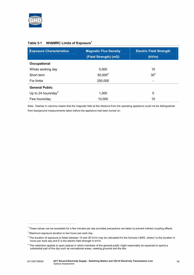
3.11 EMF and Electrical InterferenceThe existence of electric and magnetic fields (EMFs) has been recognized since electricity wasdiscovered and their characteristics have been the subject of many scientific studies around the world.Research conducted over the past 25 years has significantly enhanced TransGrid’s knowledge of EMFs.TransGrid relies on expert advice on this matter from competent health authorities in Australia and fromaround the world.
Electric field strength is related to voltage, is measured in thousands of volts per metre (kV/m) anddiminishes with increasing distance from the source (conductors). A magnetic field is only present whenan electric current is flowing, with the strength of a magnetic field measured in milliGauss (mG) whichrapidly decreases with distance from the source. Common objects are able to shield or form a barrier toelectric fields, but not magnetic fields (ESSA 2004).
Magnetic fields in the immediate vicinity of power lines are typically 10-200 mG under the line, 2-50 mGat the edge of the easement (typically 15 to 35 metres from the centre line) and 1-15 mG at a distance of50 metres from the line (TransGrid 2009b). TransGrid takes a prudent approach to design and siting ofits infrastructure, so as to eliminate or reduce long-term exposures of the public to magnetic fields andmaintain its commitment to public safety.
Limits for electric and magnetic field strength, according to the National Health and Medical ResearchCouncil (NHMRC), are illustrated in Table 3-1. Consequently, TransGrid has employed a 60 metreminimum easement width for a 330 kV Single Circuit Steel Tower construction, within which houses,buildings and other substantial constructions are prohibited (TransGrid 2010).
1423/13367/58928 ACT Second Electricity Supply - Switching Station and 330 kV Electricity Transmission LineOptions Assessment
Table 3-1 NH&MRC Limits of Exposure1
Exposure Characteristics Magnetic Flux Density
(Field Strength) (mG)
Electric Field Strength
(kV/m)
Occupational
Whole working day
Short term
For limbs
5,000
50,0002
250,000
10
303
-
General Public
Up to 24 hours/day4
Few hours/day
1,000
10,000
5
10
Note: Dashes in columns means that the magnetic field at this distance from the operating appliance could not be distinguished
from background measurements taken before the appliance had been turned on.
1 These values can be exceeded for a few minutes per day provided precautions are taken to prevent indirect coupling effects.2 Maximum exposure duration is two hours per work day.3 The duration of exposure to fields between 10 and 30 kV/m may be calculated fro the formula t≤80/E, where t is the duration in
hours per work day and E is the electric field strength in kV/m.4 This restriction applies to open spaces in which members of the general public might reasonably be expected to spend a
substantial part of the day such as recreational areas, meeting grounds and the like.

1523/13367/58928 ACT Second Electricity Supply - Switching Station and 330 kV Electricity Transmission LineOptions Assessment
4. Options Assessment
4.1 OverviewThe five potential switching station options, which have been identified, are each associated with one tothree potential line route options (as illustrated in Figure 1-1). All switching station options are locatednorth-west of the existing Canberra 330 kV Substation. The potential line routes make the connectionbetween the switching station options (Yass transmission line) and the Williamsdale transmission line tothe south.
Four feasible options for crossing the Upper and Lower Tumut transmission lines have been identified inblue in Figure 1-1 and labelled as Crossing 1 to 4 from east to west. Crossing options 1, 3 and 4 areassociated with line route options and therefore the constraints associated with these crossings havebeen considered in the analysis of the line route options. However, crossing 2 has been assessedseparately as it is not associated with any of the proposed line routes.
The following sections provide discussion on the five switching station options, associated transmissionline routes and crossing 2. Where more is known about a potential environmental constraint, this isstated. A general summary of the environmental and planning issues as they relate to the options is alsoprovided.

1623/13367/58928 ACT Second Electricity Supply - Switching Station and 330 kV Electricity Transmission LineOptions Assessment
5. Option 1 Assessment
5.1 Switching Station Option 1Option 1 for the Switching Station is located on Lot 1 DP 771051 at Wallaroo in NSW. The site would beaccessed off Parkwood Road, north-west of the ACT-NSW border. Three potential line route optionshave been identified for this switching station (refer to Figure 5-1).
The topography for this site is favourable, as it lies within a relatively flat area with easy access fromParkwood Road for construction.
Transmission line route 1A has none or few topographic limitations as it follows the existing Yasstransmission line for much of its route and the landscape is gently undulating with no significant drainagelines.
Transmission line route 1C crosses some significant drainage lines which have steeply sloping banks.The placement of towers along this route may be limited by the steep slopes and width of the drainagelines. Further, the location of temporary and permanent access tracks would be influenced by thesesteep slopes and the proximity to the Murrumbidgee River. Hence, the topography of the site across lineroute 1C may impact on tower locations and present erosion risk during construction.
The line route proposed for 1B crosses undulating land and drainage lines, however, the degree of slopeis less than line route 1C. Although there is a high erosion risk during construction there is unlikely to bean ongoing risk once the transmission line is constructed.
This switching station site contains very few ecological constraints. No mature or hollow bearing trees ormid-storey vegetation are present on the site and the groundcover is dominated by common exoticvegetation species. This vegetation community is common and widespread in the surroundinglandscape and placement of the switching station at this site is not likely to have a significant impact onthreatened species, populations or ecological communities of the NSW or ACT.
5.2 Route Option 1AThis proposed line route is approximately 2.65 km in length, crosses the Upper and Lower Tumut 330 kVtransmission lines (Upper and Lower Tumut Lines) at crossing number 1, and would connect to theWilliamsdale transmission line at tower 4. The line commences at the switching station and heads in asouth easterly direction parallel to the existing Yass transmission line. The route traverses grazing landprior to entering the ACT and the ACT NOWaste property, where it runs within about 200 metres ofresidences. Some of the line would be located within active landfill area. South of the ACT NOWasteboundary, the line route traverses grazing land once again prior to connecting to the Williamsdale line.
On the basis of the ecological assessment, this route option would be the preferred option if the sub-station is located at option 1. The route passes through grazing land that is common and widespreadthroughout the local landscape. The groundcovers are dominated by exotic species and there are nohabitat features such as hollow bearing trees, native grasslands or rocky habitats that provide preferredhabitat for threatened species, populations or ecological communities.

Option 1
Existing residences
Canberra Nature Reserve
AHIMS registered site
ETL Crossings
Crossing 4Crossing 3
Crossing 2
Crossing 1
Parkwood Road
Parkw
ood Road

1823/13367/58928 ACT Second Electricity Supply - Switching Station and 330 kV Electricity Transmission LineOptions Assessment
5.3 Route Option 1BThis line route starts at the switching station, crosses the Upper and Lower Tumut lines at crossingnumber 3, and connects at tower 7 on the Williamsdale transmission line. The length of the route isapproximately 3.2 km.
This line route may have an impact on rocky outcrops that are known habitat of the Pink-tailed Worm-lizard. This line route may remove a limited number of mature trees and some understorey species,however it would not impact on Box Gum Woodland. By connecting at tower 6 on the Williamsdaletransmission line (as opposed to tower seven as illustrated in Figure 1-1) there would be a reducedimpact on the tree planting that surrounds tower seven on this line. Further, the sympathetic placementof structures along this route may limit the impact on rocky habitats and the subsequent impact on nativespecies.
5.4 Route Option 1CThis route option starts at the switching station, crosses the Upper and Lower Tumut lines at crossingnumber 4, and terminates at tower 7 on the Williamsdale transmission line. The length of the line routeoption is approximately 3.1 km.
This line route option would require the removal of approximately 1.8 hectares of planted woodland at thesouthern end of the route where the proposed transmission line meets the existing Canberra –Williamsdale 330 kV transmission line. This plantation qualifies as the Endangered EcologicalCommunity Yellow Box Red Gum Grassy Woodland, listed under the NC Act. The placement of thisroute may also impact on rocky habitat that is known habitat for the Pink-tailed worm Lizard.
5.5 Environmental ConstraintsThe environmental constraints associated with the infrastructure described above is summarised in Table5-1.
Table 5-1 Option 1 Environmental Constraints
Issue Constraints
Land-use constraints Potential land-use conflicts exist due to the existing West Belconnen Landfill(and its associated 500 metre development restriction zone), and existinghouses and proposed residential expansion areas outlined in Section 3.3.
Contaminated Land Line route 1A would traverse the Parkwood waste disposal site and landfill.Given the known land uses currently existing on site, it is considered highlylikely that these properties would be subject to significant contaminationissues.
There are no known contamination issues associated with route 1B or 1C.
Heritage Line route 1A would traverse Block 1586. Part of this Block is associatedwith aboriginal remains (TaMS 2009).

1923/13367/58928 ACT Second Electricity Supply - Switching Station and 330 kV Electricity Transmission LineOptions Assessment
Issue Constraints
Topography There are no limitations for the switching station site or transmission lineroute 1A.
The line route proposed for 1B crosses undulating land and drainage lines,however, the degree of the slope is not as steep as for line route 1C.
Transmission line route 1C traverses steeply sloping, wide drainage lineswhich would have limitations for tower placement due to erosion risk andaccess.
Surface Water Line route 1B and 1C may result in some surface water issues due to theproximity to ephemeral drainage gullies which feed directly into theMurrumbidgee River. Erosion may also be exacerbated due to the steeptopography.
Development of the switching station site should minimise the impact toephemeral drainage lines, and the foundations for 1A and 1B line routesshould not be placed within ephemeral drainage lines.
Flora and Fauna There were no ecological limitations identified for the location of theswitching station and transmission line route 1A. The groundcovervegetation which would be removed is common throughout the study area.
Transmission line route 1B would potentially impact on rocky outcrops whichare known habitat of the NC, TSC and EPBC Act listed Pink-tailed Worm-lizard. This route would also remove approximately 0.7 hectares of NC Actlisted Box Gum Woodland.
Transmission line route 1C would impact on the Pink-tailed Worm-lizardhabitat and also remove approximately 1.8 hectares of NC Act listed BoxGum Woodland.
Bushfire Hazard Bushfire hazard:
Grassland fuels surrounding the site are regularly reduced through grazingpressure.
Fire behaviour would not be mitigated as a result of a restricted fire runand/or fire head width at this location.
The site is upslope from the direction of predominant winds (west throughthe north) during severe conditions.
Grassfires could approach from all directions.
Defendability:
Areas adjacent to the switching station site would be readily accessed due tothe construction of associated access tracks to and around each site.Further, the switching station would be equipped with fire suppressionequipment to respond to fires in the immediate vicinity.
The site would be less than 500 m from Parkwood Road but not asaccessible as switching station options 3 and 5.
Visual Impacts Line route 1A may attribute to cumulative visual impacts at the existingresidences, Parkwood Road, Parkwood Recycling Estate, Parkwood wastedisposal site, and proposed residential development area.
Line route 1B may result in visual impacts to the future subdivision area.
2023/13367/58928 ACT Second Electricity Supply - Switching Station and 330 kV Electricity Transmission LineOptions Assessment
Issue Constraints
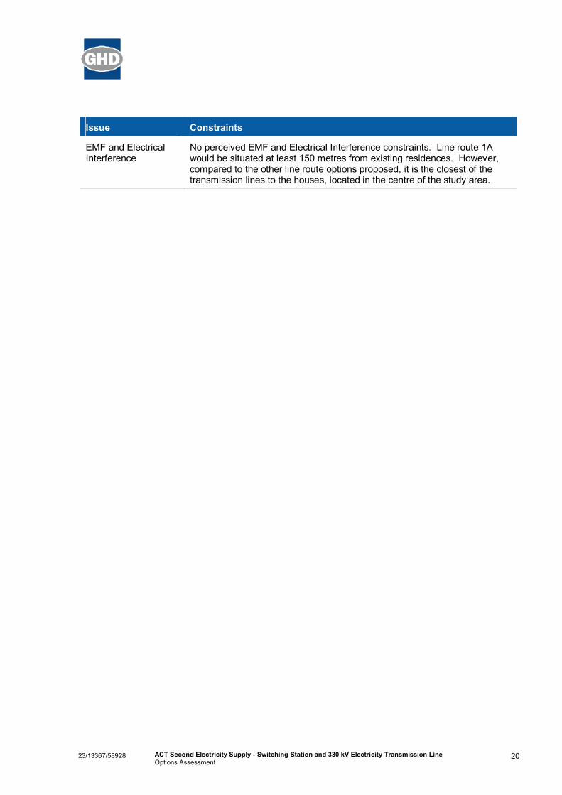
EMF and ElectricalInterference
No perceived EMF and Electrical Interference constraints. Line route 1Awould be situated at least 150 metres from existing residences. However,compared to the other line route options proposed, it is the closest of thetransmission lines to the houses, located in the centre of the study area.

2123/13367/58928 ACT Second Electricity Supply - Switching Station and 330 kV Electricity Transmission LineOptions Assessment
6. Option 2 Assessment
6.1 Switching Station Option 2This proposed switching station is situated on grazing land in NSW, directly north of and adjacent to theexisting Yass transmission line. The proposed site slopes to the south west towards the MurrumbidgeeRiver. Two potential line route options have been identified for this switching station (refer to Figure 6-1).
This site is flat to gently undulating and would not have topographic limitations for the placement of theswitching station. Access would be from Parkwood Road and would not be limited by slope or aspect.Line route option 2A would not be limited by topographic features as it is generally gently undulating andcrosses one drainage line located between towers eight and nine on the Yass transmission line.Transmission line route 2B would cross four major drainage lines that would present limitations due tothe steep topography. The drainage lines all have steep slopes that would present an erosion risk duringconstruction and would influence the location of temporary and permanent access tracks. The steepslopes of the drainage lines may also impact on the placement of towers along this route.
A number of AHIMS Registered Sites have been recorded to the north of this location. The closest ofthese is about 200 metres west within the Yass transmission line easement. This Site is referred to as‘GRGQ1; Ginninderra Falls’ and is described as an open campsite.
This site is the most westerly of the five options. The site is cleared grazing land with a predominantlyexotic understory, no mid-storey vegetation and scattered mature trees. This vegetation is common inthe surrounding landscape and the placement of the switching station at this site would not have asignificant impact on threatened species, population or ecological communities.
6.2 Route Option 2ALine route option 2A is approximately 3.5 km in length and traverses grazing land in a south eastdirection immediately adjacent to and north of the existing Yass transmission line. The proposed routeparallels the Yass transmission line from tower 9 (in NSW) to tower 5 (in the ACT). The route passesthrough ACT NOWaste property and the active landfill, where it angles south across grazing landtowards the Williamsdale transmission line and connects to tower 4. This route crosses the Upper andLower Tumut lines at crossing 1.
Grazing land is common in the study area, and this route would not require the removal of mature orhollow-bearing trees, native grasslands or rocky habitats. Hence, the placement of a transmission lineon this route would not impact on threatened species, populations or ecological communities.
6.3 Route Option 2BLine route option 2B is approximately 3.85 km in length, and crosses the Upper and Lower Tumut lines atcrossing 4. It commences at the switching station and crosses over the existing Yass transmission lineto head in a southerly direction. The route is mostly within grazing land in NSW prior to entering the ACTand the Canberra Nature Reserve. Parts of this route are steep being proximal to the MurrumbidgeeRiver. It crosses a number of drainage lines and gullies and would require the removal of a large numberof trees prior to connecting to the number 7 angle tower of the Williamsdale transmission line.

Option 2
Existing residences
Canberra Nature Reserve
AHIMS registered site
ETL Crossings
Crossing 4Crossing 3
Crossing 2
Crossing 1
Parkwood Road
Parkw
ood Road

2323/13367/58928 ACT Second Electricity Supply - Switching Station and 330 kV Electricity Transmission LineOptions Assessment
This route would involve the removal of vegetation including approximately 1.8 hectares of NC Act listedBox Gum Woodland surrounding tower seven on the Williamsdale line. This route option may alsoinclude the removal of mature trees and understorey vegetation from the drainage lines it crosses. Rockoutcrops may also be impacted by the placement of a line on this route, with the potential to significantlyimpact on the Pink-tailed Worm-lizard due to habitat disturbance.
6.4 Environmental ConstraintsThe environmental constraints associated with the infrastructure described above is summarised in Table6-1.
Table 6-1 Option 2 Environmental Constraints
Discipline Constraints
Land-use constraints It is evident that route 2A has the potential to cause some land use conflictgiven the proximity to the development restriction zone whilst route 2Bextends further into the River Corridor.
The West Belconnen Landfill (with a 500 metre development restrictionzone) and a proposed residential expansion area are all located in thegeneral vicinity of the proposed development.
Contaminated Land Line route 2A would traverse the Parkwood waste disposal site and landfill.Given the known land uses currently existing on site, it is considered highlylikely that these properties would be subject to significant contaminationissues.
There are no known contamination issues associated with route 2B.
Heritage The switching station site is located about 200 metres east of an AHIMSRegistered Site. This Site is referred to as ‘GRGQ1; Ginninderra Falls’ andis described as an open campsite.
Line route 2A would traverse Block 1586. Part of this Block is associatedwith aboriginal remains. Line route 2B would not traverse any areas ofknown heritage or archaeological significance.
Topography There would be no limitations for the location of the switching station andtransmission line route 2A.
Transmission line route 2B would cross four major drainage lines that wouldpresent limitations due to the topography. The location of towers along theroute would be influenced by erosion risk and access limitations due to thesteep slopes of the drainage line.
Surface Water Line route 2B may result in some surface water issues due to its proximity toephemeral drainage gullies which feed directly into the Murrumbidgee River.Erosion may also be exacerbated due to the steep topography.
The foundations for line route 2B should not be placed within ephemeraldrainage lines.
Ginninderra Creek is located less than one kilometre from the switchingstation site.

2423/13367/58928 ACT Second Electricity Supply - Switching Station and 330 kV Electricity Transmission LineOptions Assessment
Discipline Constraints
Flora and Fauna The construction of the switching station would not have ecologicallimitations as it is located on grazing land that is common across the studyarea.
Transmission line route 2A would not have significant ecological constraintsas it is traverses mostly grazing land that is common and widespread acrossthe study area.
Transmission line route 2B would involve the removal of up to 1.8 hectaresof the NC Act listed Box Gum Woodland. It would also have the potential tosignificantly impact the Pink-tailed Worm-lizard due to impacts on rockoutcrops which area known habitat for this species.
Bushfire Hazard Bushfire hazard:
Grassland fuels surrounding the site are regularly reduced through grazingpressures.
Fire behaviour would not be mitigated as a result of a restricted fire runand/or fire head width at this location.
The site is slightly upslope or at least flat from the direction of predominantwinds (west through the north) during severe fire conditions.
Grassfires could approach from all directions.
Defendability:
Areas adjacent to the switching station site would be readily accessed due tothe construction of associated access tracks to and around each site.Further, the switching station would be equipped with fire suppressionequipment to respond to fires in the immediate vicinity.
The site would be less than 500 m from Parkwood Road but further from firesuppression services than Options 1, 3 and 5.
Visual Impacts Line route 2A may attribute to cumulative visual impacts at existingresidences, traffic on Parkwood Road, and the future potential subdivisionarea.
Line route 2B may result in visual impacts to future potential subdivision areadue to the length of the transmission line.
Visual impacts are likely to be greater for residential dwellings near theMurrumbidgee River due to their proximity and extent of views.
The switching Station may result in visual impacts to traffic on ParkwoodRoad.
EMF and ElectricalInterference
There are no apparent EMF and Electrical Interference constraints.

2523/13367/58928 ACT Second Electricity Supply - Switching Station and 330 kV Electricity Transmission LineOptions Assessment
7. Option 3 Assessment
7.1 Switching Station Option 3The location of the switching station for this option is situated on a drainage line. The area slopes in asoutherly direction towards the Murrumbidgee River. The site is located on grazing land and is proximalto at least three residences located to the south. The site is immediately adjacent to the ACT NOWasteactive landfill and an access road used by the residents (refer to Figure 7-1).
The construction of the switching station on this site would require considerable earth works anddiversion of the existing drainage, with an increased risk of erosion. For this reason, this site is notconsidered favourable for the location of the switching station. However, the proposed line route doesnot appear to be limited as the route passes through gently undulating land.
This site does not contain features that are likely habitat for threatened species, populations or ecologicalcommunities. It is located on grazing land that does not contain mature trees or understorey vegetationand the groundcovers are dominated by exotic pasture species. The line route also passes through theACT NOWaste property before connecting to tower four on the Williamsdale transmission line. Thisroute option would involve the removal of planted trees along the property boundary, however, thepotential impact of this on native fauna in the study area is considered to be low. Locating the switchingstation and associated line route at this location is unlikely to have an impact on threatened species,population or ecological communities of the area.
7.2 Route Option 3AThe line route proposed for this switching station is approximately 2.85 km in length and is largelycontained within the ACT NOWaste property, including an active landfill area. Once it passes over thesouthern boundary of the landfill (along which there are some screen plantings), the route traversesslightly undulating grazing land prior to connecting to the Williamsdale transmission line at tower 4. Thisoption would contain all project infrastructure within the ACT. The line route crosses the Upper andLower Tumut lines at crossing 4.
7.3 Environmental ConstraintsThe environmental constraints associated with the infrastructure described above is summarised in Table7-1.

Option 3
Option 5
Existing residences
Canberra Nature Reserve
AHIMS registered site
ETL Crossings
Crossing 4Crossing 3
Crossing 2
Crossing 1
Parkwood Road
Parkw
ood Road

2723/13367/58928 ACT Second Electricity Supply - Switching Station and 330 kV Electricity Transmission LineOptions Assessment
Table 7-1 Option 3 Environmental Constraints
Discipline Constraints
Land-use constraints This option has the potential to cause significant land use conflict as both theswitching station and line route are situated within the ACT NOWastedevelopment restriction zone.
The West Belconnen Landfill (with a 500 metre development restrictionzone) and a proposed residential expansion area are all located in thevicinity of the proposed development.
Contaminated Land Line route 3A would traverse the Parkwood waste disposal site and landfill.Given the known land uses currently existing on site, it is considered highlylikely that these properties would be subject to significant contaminationissues.
Heritage Line route 3A would traverse Block 1586. Part of this Block is associatedwith aboriginal remains.
Topography The location of the switching station for this option is situated on a drainageline. The area slopes in a southerly direction towards the MurrumbidgeeRiver. For this reason this location is not considered favourable intopographic terms.
Erosion may be exacerbated for line route 3A due to steep topography.
Surface Water The switching station would be situated on a drainage line, resulting insurface water issues in the immediate area and ultimately the MurrumbidgeeRiver.
Line route 3A may result in some surface water issues due to its proximity toephemeral drainage gullies which feed directly into the Murrumbidgee River.
It is also preferable for the foundations for line route 3A not to be placedwithin ephemeral drainage lines.
Flora and Fauna The switching station and transmission line at this site would not haveecological constraints.
This option may require that the planted trees along the ACT NOWaste siteboundary be removed, however, they do not provide preferred habitat forthreatened species or populations.

2823/13367/58928 ACT Second Electricity Supply - Switching Station and 330 kV Electricity Transmission LineOptions Assessment
Discipline Constraints
Bushfire Hazard Bushfire hazard:
Grassland fuels surrounding the site are regularly reduced through grazingpressures.
Fire behaviour would not be mitigated as a result of a restricted fire runand/or fire head width at this location.
The site is slightly downslope from the direction of predominant winds (westthrough the north) during severe fire conditions.
Grassfires could approach from all directions, except to the east.
Defendability:
Areas adjacent to the switching station site would be readily accessed due tothe construction of associated access tracks to and around each site.Further, the switching station would be equipped with fire suppressionequipment to respond to fires in the immediate vicinity.
The site would be less than 500 m from Parkwood Road but further fromCanberra than Option 5.
Visual Impacts Line route 3A may attribute to cumulative visual impacts at existingresidences, traffic on Parkwood Road, and the proposed residentialdevelopment area.
The switching station may also result in visual impacts to traffic on ParkwoodRoad.
EMF and ElectricalInterference
There are no apparent EMF and Electrical Interference constraints.

2923/13367/58928 ACT Second Electricity Supply - Switching Station and 330 kV Electricity Transmission LineOptions Assessment
8. Option 4 Assessment
8.1 Switching Station Option 4The location of the switching station for this option is directly on an active landfill area within ACTNOWaste property. The site is generally flat to undulating, however it has and continues to be subject toearthworks which have the capacity to change the topography at this site. The amount of earthworksrequired at site could vary dramatically depending on the topography at the site and commencement ofconstruction. The proposed line route does not appear to be limited as the route passes through gentlyundulating land (refer to Figure 8-1).
Locating the switching station at this site would not have an effect on threatened species, populations orecological communities. The transmission line route for this option would remove up to five plantedeucalypts form a tree planting along the boundary of the ACT NOWaste site, however, this would nothave a significant impact on threatened species, populations or ecological communities either. Theswitching station would be located in a highly disturbed location (being active landfill) that is not currentlyproviding favourable habitat for native flora or fauna.
8.2 Route Option 4AThe proposed line is approximately 0.95 km in length and crosses the ACT NOWaste southern boundary(along which there are some screen plantings) and traverses slightly undulating grazing land prior toconnecting to the Williamsdale transmission line at tower 4. This option would contain all projectinfrastructure within the ACT, assisting in legislative and planning approval streamlining and processing.The line route crosses the Upper and Lower Tumut lines at crossing 1.
8.3 Environmental ConstraintsThe environmental constraints associated with the infrastructure described above is summarised in Table8-1.

Option 4
Existing residences
Canberra Nature Reserve
AHIMS registered site
ETL Crossings
Crossing 4Crossing 3
Crossing 2
Crossing 1
Parkwood Road
Parkw
ood Road

3123/13367/58928 ACT Second Electricity Supply - Switching Station and 330 kV Electricity Transmission LineOptions Assessment
Table 8-1 Option 4 Environmental Constraints
Discipline Constraints
Land-use constraints As the switching station option is situated within the development restrictionzone of the physical perimeters of the West Belconnen Landfill, there is thepotential for significant land use conflict.
The West Belconnen Landfill (with a 500 metre development restrictionzone) and a proposed residential expansion area are located in the vicinity ofthe proposed development.
Contaminated Land The switching station and line route 4A would be located within parts of theParkwood waste disposal site and landfill. Given the known land usescurrently existing on site, it is considered highly likely that these propertieswould be subject to significant contamination issues.
Heritage The switching station and line route 4A would traverse Block 1586. Part ofthis Block is associated with aboriginal remains.
Topography There are no apparent limitations for the switching station or transmissionline route 4A. However, any future development should consider potentialsoil erosion issues.
Surface Water No apparent surface water constraints.
Flora and Fauna The potential impact on threatened species, populations or ecologicalcommunities from a switching station at this site is considered negligible.
The transmission line route for this option would remove up to five plantedeucalypts from a tree planting (along the ACTNOWaste boundary), however,this would not have a significant impact on threatened species, populationsor ecological communities.
Bushfire Hazard Bushfire hazard:
Grassland fuels surrounding the site are regularly reduced through grazingpressures.
To the east, north, and northwest there is very little bushfire fuel and the siteis exposed to grassfires only from the west through to the south.
Defendability:
Areas adjacent to the switching station site would be readily accessed due tothe construction of associated access tracks to and around each site.Further, the switching station would be equipped with fire suppressionequipment to respond to fires in the immediate vicinity.
The site would be less than 500 m from Parkwood Road and closer toCanberra than Options 1, 2, 3 and 4.
Visual Impacts The switching station and line route 4A may result in visual impacts atexisting residences and the proposed residential development area.
EMF and ElectricalInterference
There are no apparent EMF and Electrical Interference constraints.

3223/13367/58928 ACT Second Electricity Supply - Switching Station and 330 kV Electricity Transmission LineOptions Assessment
9. Option 5 Assessment
9.1 Switching Station Option 5The location proposed for the switching station is located on ACT NOWaste property adjacent toParkwood Road, which is currently used for the sorting and stockpiling of waste. This option wouldrequire the removal of a number of mature trees presently screening the active waste stockpiles fromtraffic on Parkwood Road, and would ensure that all project infrastructure is contained within the ACT(refer to Figure 9-1).
This site is generally flat to gently undulating and there would be no topographic constraints for theswitching station or the transmission line routes. The substation and transmission lines would beadjacent to and within the ACT NOWaste facility which currently contains temporary and permanentbuildings, sheds and storage areas.
This site would be located in an area that has been planted as a visual screen for the ACT NoWastefacility. The tree planting has a range of local and non-local native eucalypts. The screen providespotential foraging and roosting sites and may also provide a movement corridor for native fauna and maybe used as a link between habitats for mobile species. The routes of the proposed transmission linesgenerally follow existing tree plantings. These tree plantings are providing habitat for native fauna andtheir removal should be avoided. The removal of tree plantings for the switching station or transmissionlines would represent a loss of habitat for native fauna.
9.2 Route Option 5ADue to its location approximately one kilometre from the Yass transmission line, there are two linesproposed for this switching station required to connect the switching station to both the Yass andWilliamsdale transmission lines, with a combined length of about 2.3 kilometres.
The route to connect to the Yass line would commence on or near the ACT/ NSW border along avegetated lane (requiring the removal of a number of trees) and also through the active ACT NOWasteproperty to the switching station, located on Parkwood Road.
The line route to connect the switching station to the Williamsdale line would either be within the activeACT NOWaste property (including active landfill areas) or within the Parkwood Road reserve. There area number of mature tree plantings within the road reserve currently screening the landfill and wastestockpiles from Parkwood Road. The line would cross three existing transmission lines (including theYass transmission line) and some grazing land prior to connecting to the Williamsdale transmission lineat angle tower 2.
This option would also ensure that all project infrastructure is contained within the ACT.
9.3 Environmental ConstraintsThe environmental constraints associated with the infrastructure described above is summarised in Table9-1.

Option 5
Existing residences
Canberra Nature Reserve
AHIMS registered site
ETL Crossings
Crossing 4Crossing 3
Crossing 2
Crossing 1
Parkwood Road
Parkw
ood Road

3423/13367/58928 ACT Second Electricity Supply - Switching Station and 330 kV Electricity Transmission LineOptions Assessment
Table 9-1 Option 5 Environmental Constraints
Discipline Constraints
Land-use constraints As the switching station option is situated within the development restrictionzone of the West Belconnen Landfill, there is the potential for significant landuse conflict.
The West Belconnen Landfill (with a 500 metre development restrictionzone) and a proposed residential development area are located in the vicinityof the proposed development.
Contaminated Land The switching station and line route 5A would be located within parts of theParkwood waste disposal site and Parkwood Road Recycling Estate. Giventhe known land uses currently existing on site, it is considered highly likelythat these properties would be subject to significant contamination issues
Heritage The switching station and line route 5A would traverse Block 1586. Part ofthis Block is associated with aboriginal remains.
Topography The site is generally flat to gently undulating and there are no apparenttopographic constraints for the switching station or transmission line routes.However, future development should consider potential soil erosion issues.
Surface Water No apparent surface water constraints.
Flora and Fauna This site would be located in an area that has been planted as a visualscreen. The screen also provides potential foraging and roosting sites fornative fauna.
The routes of the proposed transmission lines generally follow existing treelines. Avoiding these tree plantings would be desirable to avoid potentialforaging and roosting resources for native fauna.
Bushfire Hazard Bushfire hazard:
Grassland fuels surrounding the site are regularly reduced through grazingpressures.
Fire behaviour would be mitigated as a result of a restricted fire run and firehead width at this location.
The site is slightly upslope or at least flat from the direction of predominantwinds (west through the north) during severe fire conditions.
The site is exposed to grassfires only from the north through to the west.
Defendability:
This is considered to be the most accessible location. Areas adjacent to theswitching station site would be readily accessed due to the construction ofassociated access tracks to and around each site. Further, the switchingstation would be equipped with fire suppression equipment to respond tofires in the immediate vicinity.

3523/13367/58928 ACT Second Electricity Supply - Switching Station and 330 kV Electricity Transmission LineOptions Assessment
Discipline Constraints
Visual Impacts The switching station and line route 5A may result in visual impacts atexisting residences, Parkwood Recycling Estate, Parkwood waste disposalsite, and the potential future subdivision area.
If the removal of vegetation, currently acting as a visual buffer, is required,the proposed development may have a significant impact on traffic onParkwood Road, residential dwellings and industrial properties to the east ofParkwood Road.
EMF and ElectricalInterference
EMF and Electrical Interference impacts may be an issue for those at theParkwood Recycling Estate and the Parkwood waste disposal site due to theproximity to the proposed infrastructure.

3623/13367/58928 ACT Second Electricity Supply - Switching Station and 330 kV Electricity Transmission LineOptions Assessment
10. Crossing 2
There are a number of points at which the proposed lines may cross the existing Upper and LowerTumut transmission lines. Crossing 2 does not currently have a proposed transmission line routecrossing at this location, however it was assessed as a potential crossing point (refer to Figure 1-1).
Crossing 2 does not have any topographic limitations as the site is gently undulating and is located awayfrom drainage lines on grazing land.
Although there are no transmission line routes currently proposed for this crossing, it was assessed forpotential habitat of threatened species, populations and ecological communities. Crossing 2 is locatedon grazing land that is common across the study area. Habitat features such as mature trees, rockyoutcrops and native grasslands would not be impacted and there is unlikely to be an impact onthreatened species, population or ecological communities.
10.1 Environmental ConstraintsAlthough none of the proposed line routes crossed the Upper and Lower Tumut lines at crossing 2, Table10-1 below outlines the environmental constraints associated with this potential crossing.
Table 10-1 Crossing 2 Environmental Constraints
Discipline Constraints
Land-use constraints A proposed residential expansion area is located in the immediate area.
Contaminated Land There are no apparent contaminated land constraints.
Heritage There are no apparent heritage constraints.
Topography There are no apparent topographic limitations for the crossing at thislocation. The site is flat to gently undulating and is located away fromdrainage lines in grazing land. However, future development shouldconsider potential soil erosion issues.
Surface Water There are no apparent surface water constraints.
Flora and Fauna There are no ecological constraints that are present at crossing 2. Thiscrossing is located on grazing land that is common across the study area.
Bushfire Hazard In relation to ETLs (and crossing of ETLs), shorter routes would have a lowerrisk associated with grassfire ignitions from construction works and faults.However, these risks were considered so low that any differences betweeneach ETL route would be insignificant.
Visual Impacts The crossing may result in visual impacts at existing residences and thefuture potential subdivision area.
EMF and ElectricalInterference
EMF and Electrical Interference impacts may be an issue for the futurepotential subdivision area due to the close proximity.

3723/13367/58928 ACT Second Electricity Supply - Switching Station and 330 kV Electricity Transmission LineOptions Assessment
11. Comparative analysis
11.1 Comparative ranking of optionsA comparative ranking of each of the switching station, line route and crossing options is provided inTable 11-1, Table 11-2, and Table 11-3 below. The ranking has been allocated on a scale of 1 to 4, withthe options with the most merit allocated a rank of 1. Therefore, the most preferred option has the lowestscore.
A comparative analysis of each complete option (including the possible combinations of switchingstation, associated line route and associated line crossing) is also provided in Table 11-4, resulting in theselection of a Total Preferred Option (TPO).
Table 11-1 Switching Station comparative ratings
Opt
ions
Land
-use
Con
flict
s
Con
tam
inat
edLa
nd
Her
itage
Topo
grap
hy
Surf
ace
Wat
er
Flor
a an
d Fa
una
Bus
hfire
Haz
ard
Visu
al Im
pact
s
EMF
and
EI
Tota
l Sco
re
Ove
rall
Ran
king
Switching Station Options
1 1 1 1 1 1 2 2 2 1 12 1
2 1 1 3 2 2 2 3 4 1 19 2
3 3 2 2 4 3 2 2 3 1 22 3
4 4 4 4 1 1 1 1 4 3 23 4
5 4 4 4 1 1 3 1 4 4 26 5
The comparative ranking for the analysis of the switching station options has shown option 1 to be themost preferred option.

3823/13367/58928 ACT Second Electricity Supply - Switching Station and 330 kV Electricity Transmission LineOptions Assessment
Table 11-2 Line route options comparative ratings
Opt
ions
Land
-use
Con
flict
s
Con
tam
inat
edLa
nd
Her
itage
Topo
grap
hy
Surf
ace
Wat
er
Flor
a an
d Fa
una
Bus
hfire
Haz
ard
Visu
al Im
pact
s
EMF
and
EI
Tota
l Sco
re
Ove
rall
Ran
king
Line Route Options
1A 4 4 4 1 1 1 1 3 2 21 4
1B 2 1 1 2 2 3 1 2 1 15 1
1C 1 1 1 4 3 4 1 1 1 17 2
2A 4 4 4 1 1 2 1 3 3 23 7
2B 2 1 1 4 4 4 1 4 1 22 5
3A 4 4 4 1 2 1 1 3 2 22 5
4A 4 3 3 1 1 1 1 2 4 20 3
5A 4 4 4 1 1 2 1 4 4 25 8
The comparative ranking for the analysis of the line route options has shown option 1B to be the mostpreferred option.
Table 11-3 Crossing options comparative ratings
Opt
ions
Land
-use
Con
flict
s
Con
tam
inat
edLa
nd
Her
itage
Topo
grap
hy
Surf
ace
Wat
er
Flor
a an
d Fa
una
Bus
hfire
Haz
ard
Visu
al Im
pact
s
EMF
and
EI
Tota
l Sco
re
Ove
rall
Ran
king
Crossing Options
1 4 1 2 1 1 1 1 3 1 15 3
2 1 1 2 1 1 1 1 3 1 12 1
3 1 1 1 1 1 3 1 2 1 12 1
4 1 1 1 4 4 4 1 4 1 21 4
The comparative ranking for the analysis of the crossing options has shown that options 2 and 3 are themost preferred.

3923/13367/58928 ACT Second Electricity Supply - Switching Station and 330 kV Electricity Transmission LineOptions Assessment
Table 11-4 Total Preferred Option Comparative Analysis
Switc
hing
Stat
ion
Opt
ion
Ass
ocia
ted
Line
Rou
te O
ptio
n
Ass
ocia
ted
Line
Cro
ssin
g
Switc
hing
Stat
ion
Com
para
tive
Ran
king
(from
Tab
le 1
1-1)
Line
Rou
teO
ptio
nC
ompa
rativ
eR
anki
ng
(from
Tab
le 1
1-2)
Line
Cro
ssin
gC
ompa
rativ
eR
anki
ng
(from
Tab
le 1
1-3)
Tota
l Sco
re
Ove
rall
Ran
king
Total Preferred Option
1 1A 1 1 4 3 8 2
1 1B 3 1 1 1 3 1
1 1C 4 1 2 4 8 2
2 2A 1 2 7 3 12 7
2 2B 4 2 5 4 11 5
3 3A 1 3 5 3 11 5
4 4A 1 4 3 3 10 4
5 5A 1 5 8 3 16 8
The comparative ranking for the Total Preferred Option (TPO) has shown that the combination ofswitching station option 1, line route 1B and Crossing 3 is the most preferred.

4023/13367/58928 ACT Second Electricity Supply - Switching Station and 330 kV Electricity Transmission LineOptions Assessment
12. Recommendation
Following comparative ranking of all the switching station and associated transmission line route options,switching station option 1 and associated line route option 1B (crossing option 3) present the leastconstrained of the options assessed. However, it is further recommended that this line route optionconnects with the Williamsdale transmission line at tower 6 to reduce the impact on the endangeredvegetation to the north of tower 7.

4123/13367/58928 ACT Second Electricity Supply - Switching Station and 330 kV Electricity Transmission LineOptions Assessment
13. References
Department of Environment, Climate Change & Water (DECCW) 2010a, Contaminated Land Register,retrieved May 27, 2010, from http://www.environment.nsw.gov.au/clmapp/aboutRegister.aspx.
Department of Environment, Climate Change & Water (DECCW) 2010b, Natural Resource Atlas: SoilProfiles, retrieved February 2, 2010, from http://www.environment.nsw.gov.au/soils/survey.htm.
Department of Environment, Climate Change & Water (DECCW) 2010c, NSW Bioregions, retrievedFebruary 3, 2010, from http://www.environment.nsw.gov.au/bioregions/BioregionsNswoutline.htm.
Department of the Environment, Water, Heritage and the Arts (DEWHA) 2010, Protected Matters Search,retrieved February 2, 2010, from http://www.environment.gov.au/epbc/protect/index.html.
Energy Supply Association of Australia Limited (ESAA) 2004, Electric and magnetic fields. What weknow.
Geoscience Australia 1966, 1:250 000 Geology Maps Wollongong, map ID SI5609, Second edition1966, NSW Department of Mines, retrieved February 2, 2010, fromhttp://www.geoscience.gov.au/bin/mapserv36?map=/public/http/www/geoportal/250/index.map&mode=browse&layer=map250&queryon=true.
Murrumbidgee Catchment Management Authority (MCMA) 2008, Murrumbidgee Catchment Action Plan,retrieved February 2, 2010, fromhttp://murrumbidgee.cma.nsw.gov.au/uploads/media/MCMA009_CAP_Web_P1_01.pdf.
NSW National Parks and Wildlife Service (2003) The Bioregions of New South Wales: their biodiversity,conservation and history. NSW National Parks and Wildlife Service Hurstville
Department of Territory and Municipal Services (TaMS) 2010, ACT Heritage Register, retrieved June 16,2010, from http://www.tams.act.gov.au/live/heritage/act_heritage_register.
TransGrid 2010, Easement Maintenance, retrieved June 16, 2010, fromhttp://www.transgrid.com.au/pe/lwp/Pages/EasementMaintenance.aspx.
TransGrid 2009, Electric and Magnetic Fields Brochure.
TransGrid 2009, Fire Protection Manual Operations and Maintenance and Bushfire Risk ManagementPlan.
Yass Valley Council (YVC) 2004, 2003/2004 State of the Environment Supplementary Report, retrievedFebruary 2, 2010, from http://www.yass.nsw.gov.au/files/2623/File/2004SupplementarySoEReport8-2.pdf.

23/13367/58928 ACT Second Electricity Supply - Switching Station and 330 kV Electricity Transmission LineOptions Assessment
GHD
2/57 Graham St Nowra NSW 2541PO BOX 621 Nowra NSW 2541T: 61 2 4424 4900 F: 61 2 4424 4999 E: [email protected]
© GHD 2010
This document is and shall remain the property of GHD. The document may only be used for the purposefor which it was commissioned and in accordance with the Terms of Engagement for the commission.Unauthorised use of this document in any form whatsoever is prohibited.
Document Status
Reviewer Approved for IssueRevNo. Author
Name Signature Name Signature Date
0 R. HudsonG. YoungL. Moore
S. Witney * Approval onfile
DRAFT N/A 01/07/2010
1 L. Moore S. Witney * Approval onfile
DRAFT N/A 05/08/2010
2 R. HudsonL. Moore
A. Beldom A. Beldom 09/08/2010