ACID SULFATE SOILS -...
43
1 ACID SULFATE SOILS GUIDEBOOK FOR VA/MD MAPSS/VAPSS TOUR, NOV. 4, 2011, IN GENERAL VICINITY OF FREDRICKSBURG, VA Edited by Del Fanning, [email protected] or [email protected] Cover pictures are described on next page, back of this page
Transcript of ACID SULFATE SOILS -...

1
ACID SULFATE SOILS GUIDEBOOK FOR VA/MD MAPSS/VAPSS
TOUR, NOV. 4, 2011, IN GENERAL VICINITY OF FREDRICKSBURG, VA
Edited by Del Fanning, [email protected] or [email protected]
Cover pictures are described on next page, back of this page

2
Cover Pictures: Top: Dr. W. Lee Daniels, Thomas B. Hutcheson, Jr. Professor of Environmental Soil Science at Virginia Tech, stands on iron oxides stained concrete of sidewalk at the Great Oaks development in Fredericksburg, VA in November, 2005. The yard surrounding the sidewalk was un-vegetated, in spite of sod being laid on the active acid sulfate soil of the yard at this site more than once -- although grass was growing along the down slope edge of the concrete – probably because of neutralization of waters carrying the iron released by acid sulfate weathering from the soil by the concrete. Lee is a main organizer and a presenter at this acid sulfate soils conference. A drive by of this and other yards at Great Oaks, most of which were remedied by heavy lime additions, is planned for this tour, time permitting, and a write-up about Great Oaks from the field trip guidebook for the acid sulfate soils tour that took place in 2006 (Fanning 2006) is in this guidebook, see pages 21-24. Bottom: a collage of pictures reproduced from Fig. 3 of Fanning et al. (2004) showing scalped land surface along the north perimeter of Stafford County Regional Airport grounds after a long dry weather spell in October, 2001, during construction of the airport. The brown oxidized zone at the top of the slope clearly stands out above the white, salt covered, lower scalped surface where some pH’s were less than 2. Inset pictures show A – exposed contact between the oxidized (brownish) and unoxidized (dark bluish gray) zones, which occurred about 3.5 meters below the natural, pre-scalping surface of the hill: B – Exposed platy soil structure with plate surfaces parallel to the scalped land surface. The structure is considered to have formed after the scalped land surface came into existence. The newly formed mineral jarosite, indicative in combination with ultra low pH of a sulfuric horizon by Soil Taxonomy, was found on some of the plate surfaces. C – Small rivulet, spring, that emanated from along the top of the unoxidized zone in low spot in natural surface topography, showing newly formed iron (hydr)oxides in the drainage way.from the acid drainage waters. The salts on the surface were identified as halotrychite, a highly hydrated ferrous iron aluminum sulfate mineral for the white salt covering the bulk of the surface of the previous unoxidized zone, and aluminocopiapite, a highly hydrated aluminum ferric iron hydroxy sulfate mineral for some lemon yellow salts that occurred along the rivulet. We will be examining soil profiles along the now largely vegetated slope during the field trip on Nov. 4, 2011. References: Fanning, D. S. (Tour Leader, Guidebook Editor). 2006. Acid sulfate soils of the U.S. Mid-Atlantic/Chesapeake Bay Region. Guidebook for tour, July 6-8, 2006 for 18th World Congress of Soil Science. University of Maryland, College Park, MD. http://www.sawgal.umd.edu/MAPSS/WCSS_Guidebook.pdf Fanning, D. S., Cary Coppock, Z. W. Orndorff, W. L. Daniels, and M. C. Rabenhorst. 2004. Upland active acid sulfate soils from construction of new Stafford County, Virginia, USA, Airport. Australian J. Soil Research 42: 527-536.

3
TABLE OF CONTENTS
Cover with explanation of cover pictures. Pages 1 and 2 Table of Contents. This page. Page 3. Overall Introduction. Page 4. STOP 1, SRAP, Stafford County, VA, Regional Airport. Pages 5-20. STOP 2, Great Oaks Development in Fredericksburg, VA, Pages 21-24. STOP 3, Captain Billy’s Restaurant, Pope’s Creek, MD, Page 25. STOP 4, Loyola Retreat House, Faulkner, MD, where the cliff face on the Potomac River, with acid sulfate weathering features and a Native American oyster shell kitchen midden, will be examined. Pages 26-41. Tour Roadlog, Pages 41-42 Acknowledgements, Page 43

4
OVERALL INTRODUCTION
This tour will have only four main stops, one of which will be for lunch, however, this tour guidebook is quite long, taking advantage of the tour guide prepared for the WCSS (World Congress of Soil Science) acid sulfate soils tour of July, 2006, from which much material for the stops of this trip are reproduced in this 2011 guidebook. A road log guide for this trip has at the last minute been produced, see pages 41-42. A main goal of the trip is to show the oxidized and unoxidized zones of the soil geologic column at Stop 1 SRAP (the Stafford County, VA Regional Airport) and at Stop 4 (the cliff on the Potomac River at the Loyola Retreat House) and some of the consequences in terms of the formation of active acid sulfate soils at Stops 1 and 2 (the Great Oaks development) in Fredericksburg. We considered an additional stop at the huge road cut with active acid sulfate soils in the Quantico Slate on Mine Road near Garrisonville, VA, but time-distance won’t permit us to visit that site. For those with an interest in that site, there are information and pictures available in the WCSS tour guidebook (Fanning, 2006), which is available on the MAPSS web site. Another site that would have been good to visit on this tour is the Carriage Hills development in Falmouth, VA, just north of, but outside the city limits of Fredericksburg. Much disturbance of sulfidic materials occurred there with active acid sulfate soils brought into existence in new home owner’s yards after the time of the WCSS tour. Information about some of the Carriage Hills acid sulfate soils situations appear in an article by Fanning and others in the Summer 09 issue of Pedologue, the MAPSS Newsletter, see reference below, which also is available on the MAPSS web site. Many of the yards at Carriage Hills were remedied thru assistance from Dr. Daniels and his team at VT and the builders at Carriage Hills with assistance from Stafford County environmental authorities to get them to do it. Those who are interested are invited to look at these publications available from the web site as cited below. Archeologists have become very interested in the oyster shell kitchen midden at Stop 4 and have helped us to gather more information about the midden for this tour, for which we owe them a big debt of gratitude. References: Fanning, D. S. (Tour Leader, Guidebook Editor). 2006. Acid sulfate soils of the U.S. Mid-Atlantic/Chesapeake Bay Region. Guidebook for tour, July 6-8, 2006 for 18th World Congress of Soil Science. University of Maryland, College Park, MD. http://www.sawgal.umd.edu/MAPSS/WCSS_Guidebook.pdf Fanning, Delvin S., Philip K. Zurheide, and W. Lee Daniels. 2009. Active acid sulfate soils in yards of homes in new housing development at the Carriage Hills Development at Falls Run in Stafford County, VA – recognized by homeowners, with an assist from Dig It, the soils exhibit at Smithsonian Museum of Natural History. The saga goes on. Pedologue, Summer 2009 Issue. http://www.sawgal.umd.edu/mapss/Pedologue/PEDOLOGUE_2009Summer.pdf

5
STOP 1
SRAP STAFFORD COUNTY, VA REGIONAL
AIRPORT
The bulk of the printed materials for this stop, pages 7-20, were prepared for the July 8, 2006, World Congress of Soil
Science Tour of Acid Sulfate Soils of the Mid-Atlantic Chesapeake Bay Region (Fanning, 2006) – see full reference on
the back of the cover page for this 2011 tour. However, descriptions of profiles made in two new soil pits for this 2011 tour appear at the end of the printed materials for this stop,
pages 15-20.
6
STOP 1 AND BEGINNING AND END OF THE TOUR STAFFORD COUNTY, VA REGIONAL AIRPORT, SRAP
There are broad areas of active acid sulfate soils, mostly Sulfaquepts or Sulfudepts by Soil Taxonomy, at SRAP. Had acid sulfate soil principles been employed by engineers who constructed the airport, around the year 2000, sulfidic materials should not have been exposed to oxidation and active acid sulfate soils should not have formed. As explained by Fanning et al. (2004) in their paper about the acid sulfate soils at SRAP, the engineers in charge of the construction claimed ignorance of knowledge about acid sulfate soils. Active acid sulfate soils formed in a few weeks or months on sulfidic materials (potential acid sulfate soil materials in general terminology) that were exposed -- both on scalped land surfaces (cuts in engineering parlance) and on the spoil that was employed to make the flat land for runways etc. and on the excess spoil which was piled to make new hills in the northeast corner of the airport. Soil scientists now employ the soils at the airport to educate people about the nature of acid sulfate soils and the need to employ sound principles in future land disturbance activities to prevent the problems associated with active acid sulfate soils from arising. Also ways of remedying and reclaiming lands where active acid sulfate soils have been bought into existence have been employed and studied here, particularly by Virginia Tech soil scientists/reclamation experts. As soil scientists we are disappointed that the lessons pertaining to the dangers of bringing active acid sulfate soils into existence by deep land disturbance, experienced at SRAP, have not been better learned and employed by community leaders so as to prevent active acid sulfate soils from coming into existence in developments such as at Great Oaks in Fredericksburg and Carriage Hills in Stafford County, and many other places, in the times since SRAP was constructed. We’ll just have to keep sounding off. The bulk of the information about acid sulfate soils at SRAP was collected and put into the guidebook for acid sulfate soils tour for the 2006 WCSS (World Congress of Soil Science) (Fanning, 2006). The pages of that guidebook pertaining to the airport are reproduced on succeeding pages, pages 7- 14. Following that, in this guidebook, pages 15-20, there are descriptions of two profiles for which backhoe trenches were opened for us at the airport by Ed Wallis, Airport Manager, for this trip. One of these descriptions is for a profile at the boundary between the oxidized and unoxidized zones along the slope and the other for more clay rich and rock like soil near the bottom of the slope. If time permits we also hope to show off a relatively undisturbed soil in the oxidized zone and an active acid sulfate soil in spoil at SRAP, and there is a “Badlands area with gullies and no vegetation a bit to the west of where the soil pits mentioned above are located. The tour group may be split into two groups to see stuff around other parts of the airport – tour around to probably be led by Lee, Zenah and Ed Wallis.

7
Fanning’s preliminary comments: (this section reproduced from Fanning, 2006) This stop will be at the Stafford County, VA, Regional Airport where large areas of sulfidic materials were exposed on scalped land surfaces and as spoil during the construction of the airport, which opened in 2002. Virginia Tech (Orndorff and Daniels) and University of Maryland (Fanning, Coppock, Rabenhorst) soil scientists have collaborated to document information on the soils, water quality and corrosion etc. at this site and Virginia Tech developed a reclamation plan that utilized heavy applications of lime-stabilized biosolids (sewage sludge) and acid and salt tolerant grass species (e.g. hard fescue) to establish vegetation on the soils of the site, most of which were active acid sulfate soils with a sulfuric horizon by Soil Taxonomy right at the surface of the soils. Results of our early (2001-2003) scientific efforts at this site and background information about the airport and its construction are covered in a joint paper presented at the 5th International Acid Sulfate Soils Conference in Australia in 2002 (Fanning et al. 2004 – see citation at the end of the soil description and data for a soil on the scalped soil surface at this site below). To save space in what we write here, reprints of the paper will be given out to trip participants. The leaders of the trip would be pleased to receive these reprints back after participants have looked at the paper, however, these can be taken as a souvenir of this trip etc. if so desired. What we are giving out essentially exhausts our supply of the reprints – that’s why we ask for them back if you don’t have a good use for them. Documentation for much of what we say at this site is in the (reprint) paper. Our planned activities for this site are to stop at the airport hangar to pick up Dr. Zenah Orndorff and Ed Wallis, Airport Manager, and to give those who need it the opportunity to use the rest rooms in the hangar. We will then proceed to examine the soil on the scalped land surface, described below, and to discuss this soil and how it developed with reference back to the paper mentioned above. If available, we may also examine a soil in spoil on flatter ground. We then plan to drive our tour group in the bus around the airport to the southwest side for a short stop and talks there. There may be opportunities for examination of some of the concrete and metal corrosion caused by waters that have seeped and flowed out of the soils. Somewhere along the way, Zenah will comment on the water quality in stream water as affected by the airport construction and the use of the biosolids in the reclamation efforts. Orndorff preliminary comments Construction of SRAP in the late 1990’s exposed over 150 ha of lower Tertiary age Coastal Plain materials as the airport runway was constructed through a deeply dissected landscape. As construction proceeded, long spur ridges were excavated to depths > 25 m, exposing significant volumes of gray, reduced, sulfidic (0.6 to 1.2 % pyritic-S; PPA up to 60 Mg CaCO3/1000 Mg material) silty sediments, which were subsequently filled into intervening valley fills to support the > 1500 m runway. Excavated sulfidic materials exceeded the capacity of the valley fills and were also placed into several large, steeply sloping excess spoil fills along a first-order stream draining the eastern section of the site. Due to the fact that the sulfidic nature of these materials was not recognized until well after all final grading was completed, the acid-forming materials were not isolated away from drainage, and in fact were essentially

8
scattered randomly, and thoroughly, throughout the site. Reclamation efforts over the past four years have been highly successful (> 90% of area is revegetated), although discrete problematic areas still exist throughout the airport. More detailed information regarding the soils and reclamation of SRAP is provided in Fanning et.al (2004) and an updated table of water quality data is provided on a subsequent page.. Provided on this page are
pictures to show some of the metal and concrete corrosion at SRAP. The first picture shows drain pipes from a sediment control pond on the south side of the airport where the pipes have been eaten thru by the acidic waters. This picture was taken by Dr. Daniels of Virginia Tech. The picture at the bottom of the page, also from Dr. Daniels, shows
concrete corrosion and iron staining in a “protected” channel on the north side of the airport.
9
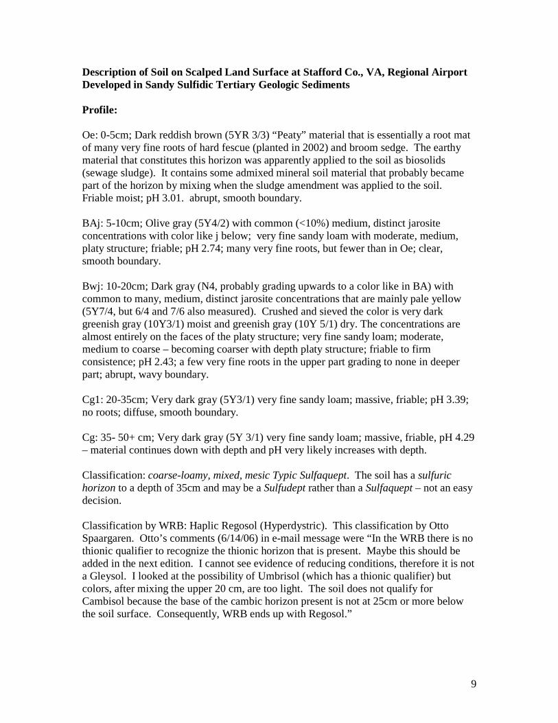
Description of Soil on Scalped Land Surface at Stafford Co., VA, Regional Airport Developed in Sandy Sulfidic Tertiary Geologic Sediments Profile: Oe: 0-5cm; Dark reddish brown (5YR 3/3) “Peaty” material that is essentially a root mat of many very fine roots of hard fescue (planted in 2002) and broom sedge. The earthy material that constitutes this horizon was apparently applied to the soil as biosolids (sewage sludge). It contains some admixed mineral soil material that probably became part of the horizon by mixing when the sludge amendment was applied to the soil. Friable moist; pH 3.01. abrupt, smooth boundary. BAj: 5-10cm; Olive gray (5Y4/2) with common (<10%) medium, distinct jarosite concentrations with color like j below; very fine sandy loam with moderate, medium, platy structure; friable; pH 2.74; many very fine roots, but fewer than in Oe; clear, smooth boundary. Bwj: 10-20cm; Dark gray (N4, probably grading upwards to a color like in BA) with common to many, medium, distinct jarosite concentrations that are mainly pale yellow (5Y7/4, but 6/4 and 7/6 also measured). Crushed and sieved the color is very dark greenish gray (10Y3/1) moist and greenish gray (10Y 5/1) dry. The concentrations are almost entirely on the faces of the platy structure; very fine sandy loam; moderate, medium to coarse – becoming coarser with depth platy structure; friable to firm consistence; pH 2.43; a few very fine roots in the upper part grading to none in deeper part; abrupt, wavy boundary. Cg1: 20-35cm; Very dark gray (5Y3/1) very fine sandy loam; massive, friable; pH 3.39; no roots; diffuse, smooth boundary. Cg: 35- 50+ cm; Very dark gray (5Y 3/1) very fine sandy loam; massive, friable, pH 4.29 – material continues down with depth and pH very likely increases with depth. Classification: coarse-loamy, mixed, mesic Typic Sulfaquept. The soil has a sulfuric horizon to a depth of 35cm and may be a Sulfudept rather than a Sulfaquept – not an easy decision. Classification by WRB: Haplic Regosol (Hyperdystric). This classification by Otto Spaargaren. Otto’s comments (6/14/06) in e-mail message were “In the WRB there is no thionic qualifier to recognize the thionic horizon that is present. Maybe this should be added in the next edition. I cannot see evidence of reducing conditions, therefore it is not a Gleysol. I looked at the possibility of Umbrisol (which has a thionic qualifier) but colors, after mixing the upper 20 cm, are too light. The soil does not qualify for Cambisol because the base of the cambic horizon present is not at 25cm or more below the soil surface. Consequently, WRB ends up with Regosol.”

10
Fanning’s comment in reply to Sparrgaren was to the effect that the low chroma colors are from geologic gleying of the parent material, thus the assignment of Cg horizon symbols. Fanning thinks that a thionic modifier is needed by WRB for this soil. This soil is similar to the one on the scalped surface at Stop 3. If an engineering cut into sulfidic materials is made, as was the case here, a sulfuric horizon can form within a few months, as here. In Soil Taxonomy this immediately advances the soil from being an Entisol (Sulfaquent?) to an Inceptisol. There are big pedogenic changes in the chemistry, and in S mineralogy (mineral transformations), as well as in the physical properties of the zone in which the sulfuric horizon has formed – this is “big bang” soil genesis. Described and sampled on Nov. 17 and 19, 2005 by D. S. Fanning, Department of Natural Resource Sciences and Landscape Architecture, University of Maryland, College Park, MD 20742-4452. Telephone: Office: 301-405-1308, Home: 301:864-5561. e-mail: [email protected] or [email protected] Area: Stafford County, VA. Location: Near middle of cut slope on N side of Airport, down from former engineering headquarters. Vegetation: Hard fescue and some broom sedge. Parent material: Very fine sand sulfidic Tertiary sediments that were in the unoxidized zone of the soil-geologic column until exposed by construction activities during the construction of the airport. Physiography – Geomorphology: Human-made slope (scalped land surface by terminology of Fanning and Fanning, 1989, textbook) in dissected Upper Coastal Plain uplands. The scalped land surface was made during the airport construction activities in about the year 2000. Slope and Aspect: About 25% smooth slope facing south. Erosion: The soil was described in the west wall of a shallow gully that has formed since the slope was made by construction in about 2001. Moisture condition when described: The soil was moist throughout. The description was made during cool weather with day time highs about 50 degrees F. Additional Notes: The faces of the platy structure in the BA and Bwj horizons are mostly covered with jarosite. The plate faces are roughly parallel to the soil surface. This demonstrates that the platy structure formed on the new, human-constructed, land surface and that the jarosite formed after the land surface was constructed. There are some fine, sand-size lignite grains/chips in the Cg horizons that appear to constitute about 5% of the sand of these horizons. Pictures of profile and landscapes follow.

11
The depth increments on the tape over profile are 10cm (about 4 inches) apart.

12
These pictures taken in November, 2005, may be compared to the pictures of this slope when it was covered with salts etc. and not vegetated in 2001, shortly after airport construction as given in the paper by Fanning et al. (2004). For some lab data for the profile, see the next page. The top picture is a close up of the profile sampling site, the bottom is the full slope.

13
Some data for total S, C, and N contents determined with a CNS analyzer at the NRCS National Soil Survey Lab on air-dry, less than 2 mm soil material, for this profile from the Stafford Regional Airport are given below. Horizon Depth (cm) Total S (%) Total C ((%) Total N (%) Oe 0-5 0.27 2.77 0.332 BAj 5-10 0.13 0.32 0.092 Bwj 10-20 1.42 0.30 0.092 Cg1 20-35 0.42 0.39 0.062 Below: Incubation data of duplicate samples of the Cg2 horizon soil materials that show that this horizon qualifies as a sulfidic material by Soil Taxonomy. Dates are in 2006. Note that the pH had already dropped from 4.29 when the sample was collected in November, 2005, until the time the incubation was started in February 2006. Sample Depthcmetc. 2/15 2/22 3/1 3/9 3/16 3/23 3/30 4/6 4/13 SRAP Cg2, 1 3.69 3.49 3.19 3.02 2.52 2.73 2.47 2.31 2.12 SRAP Cg2, 2 3.73 3.48 3.05 3.02 2.62 2.75 2.44 2.33 2.06 References: Fanning, D. S. and M. C. B. Fanning. 1989. Soil: Morphology, Genesis, and Classification. John Wiley and Sons, New York. 395 pages. Fanning, D. S., Cary Coppock, Z. W. Orndorff, W. L. Daniels, and M. C. Rabenhorst. 2004. Upland active acid sulfate soils from construction of new Stafford County, Virginia, USA, Airport. Austrlian J. Soil Research 42: 527-536.

14
The table below repeats data given in Table 1 of Fanning et al. (2004) and gives some additional data from more recent dates (Sep-03, Sep-05 and Mar-06). dS/m -----------------------mg/L----------------------
Location Date pH EC Fe Al S NH3-N NO3-N SW 4 Apr-02 5.12 121 6.1 0.5 2 ND 0.09
(Above site) Jun-02 5.75 93 6.8 0.1 1 0.52 0.29 Nov-02 4.69 636 0.6 0.3 6 0.32 0.41 Sep-03 5.29 201 1.7 0.1 2 0.28 1.38 Sep-05 ND ND ND ND ND ND ND Mar-06 ND ND ND ND ND ND ND
SW 1 Feb-02 3.18 816 42.0 12.0 107 ND ND (In Site) Apr-02 2.93 1489 62.0 25.0 195 0.74 0.02
Jun-02 2.92 2080 67.0 7.0 294 46.20 0.69 Nov-02 3.49 1496 34.0 17.0 252 3.95 8.69 Sep-03 3.49 646 8.2 2.1 77 1.21 0.88 Sep-05 6.31 230 14.5 0.1 21 0.17 0.19 Mar-06 4.28 142 2.8 2.3 35 0.00 0.14
SW 6 Apr-02 3.30 1267 42.0 18.0 147 0.88 ND (Below Site) Jun-02 6.32 728 44.0 0.7 66 16.10 0.12
Nov-02 4.20 143 19.0 10.0 136 2.36 4.79 Sep-03 4.39 515 0.5 2.8 70 0.86 1.55 Sep-05 6.72 431 8.4 1.3 17 0.08 0.10 Mar-06 4.80 315 2.9 3.7 36 0.12 0.42
SW 7 May-
02 5.48 58 2.9 0.2 5 0.13 0.05 (Above Site) Jun-02 6.60 56 2.4 ND 3 0.43 0.04
Nov-02 5.01 96 1.7 0.1 8 0.84 0.89 Sep-03 5.94 206 1.2 0.1 4 0.13 0.88 Sep-05 6.56 48 2.2 0.1 2 0.00 0.04 Mar-06 5.35 63 0.5 0.1 5 0.02 0.15
NRCS Dam Mar-02 3.30 590 8.7 7.7 61 0.14 0.36
(Below Site) May-
02 5.97 535 7.4 0.2 66 17.32 0.90 Jun-02 7.37 531 0.8 ND 57 18.34 0.08 Nov-02 5.23 962 0.3 1.0 138 1.86 12.80 Sep-03 7.03 406 0.9 0.1 43 0.23 1.66 Sep-05 6.30 132 1.1 0.1 10 0.00 0.10 Mar-06 5.92 122 0.8 0.1 12 0.00 0.04

15
SOIL DESCRIBED IN NEW UPSLOPE PIT, REFERRED TO AS PIT 1, FOR VAPSS/MAPSS ACID SULFATE SOILS TOUR ON NOV. 4, 2011. THIS PIT WAS DUG ACROSS THE BOUNDARY OF WHERE THE UPPER PART OF THE SOIL PROFILE EXPOSED IS IN THE OXIDIZED ZONE OF THE SOIL- GEOLOGIC COLUMN AND WHERE DOWNSLOPE THE OXIDIZED ZONE WAS COMPLETELY SCALPED AWAY DURING AIRPORT CONSTRUCTION, SUCH THAT THE NEW SOIL, FOLLOWING THE SCALPING IS IN THE UNOXIDIZED ZONE OF THE ORIGINAL SOIL-GEOLOGIC COLUMN. Description of soil profile on scalped land surface at Stafford Co., VA, Regional Airport. This profile is developed in very fine sand sulfidic Tertiary Geologic Sediments. It was described in a new backhoe pit, opened Oct. 3. 2011 by Ed Wallis, for VAPSS/MAPSS acid sulfate soils workshop tour Nov. 4, 2011. The profile was described on the land surface about 2 meters upslope from the boundary between the oxidized zone and the unoxidized zone on the scalped land surface. Profile: A: 0-7cm; dark reddish brown (5YR 3/3) silt loam that is essentially a root mat of many fine and very fine roots of grass, hard fescue, planted in 2002 after lime-stabilized biosolids (sewage sludge) were added and mixed into this soil that was previously unvegetated on a scalped land surface; moderate to strong, very fine and fine granular structure; friable; pH 8.1, apparently reflecting presence of calcium carbonate, probably formed from burned-slaked lime of the biosolids; abrupt, smooth boundary. Bw: 6-31cm; strong brown (7.5YR 5/8), with common, fine, distinct 7.5YR 5/3 redox depletions, especially in the lower part; very fine sandy loam with weak, fine, subangular blocky structure with a tendency to weak medium platy primary structure in the lower part; very friable; pH 5.67; common very fine and few fine roots in upper half, but few roots of any kind below; abrupt, smooth boundary that dips into the hill upslope of the profile. This horizon becomes thicker upslope and gets thinner down slope until it is absent about 2 meters down the slope where this horizon that represents the lower part of the oxidized zone of the original (pre-disturbance oxidized zone) soil geologic column is no longer present. Bwj: 31-54cm; brown (5YR 5/2) in upper part grading to dark grayish brown (10YR 4/2) matrix in lower part with common fine (but elongated laterally along faces of weak platy structure) prominent 5Y 7/4 jarosite and 7.5YR 5/8, probable lepidocrocite, redox concentrations; very fine sandy loam; friable; pH 4.0 in upper part and 3.9 in lower part; based on chemical tests – no violent reaction with 30% hydrogen peroxide -- see notes pertaining to this profile, this horizon is judged to not be a sulfuric horizon, but to be a post-active acid sulfate soil material; abrupt, irregular boundary Cgse: 54-140+cm; very dark bluish gray (5B 3/1) very fine sandy loam or perhaps loamy very fine sand; massive; friable with tendency to be firm in situ; no roots

16
present; pH 4.1. Based on previous pH with incubation test and a violent reaction within about a minute after the addition of hydrogen peroxide to a sample of this soil material from a depth of about 80cm with 30% hydrogen peroxide, this soil material qualifies as a sulfidic material by Soil Taxonomy. Described Oct. 4, 2011 by D. S. Fanning, Department of Environmental Science and Technology, University of Maryland, College Park, MD 20742-4452. Telephone: Office: 301-405-1308, Home: 301:864-5561. e-mail: [email protected] or [email protected] A picture of the profile appears on the next page. Classification: As described this soil does not have a sulfuric horizon occurring above a depth of 50cm, thus it does not qualify as a Sulfaquept or a Sulfudept, however, it does have sulfidic materials occurring at a depth of 54cm and below, thus the soil should qualify for a Sulfic subgroup as that subgroup is recognized elsewhere in Soil Taxonomy. If a cambic horizon is recognized for the Bw horizon, the soil should qualify as a Dystrudept, if a cambic horizon is not recognized, the soil should qualify as a Udorthent. A Scalpic subgroup, to recognize that the soil is on a scalped land surface would be recommended by the system for highly human-influenced soils by Fanning and Fanning (1989). The family classification remains to be worked out. Note that the soil as described is of very minor extent, it occurs on the boundary between the Sulfudepts/Sulfaquepts downslope and the Dystrudepts/Udorthents upslope. Area: At Stafford County, VA, Regional Airport, Stafford County, VA. Location: Middle to upper part of cut slope on N side of Airport, down from former engineering headquarters. GPS coordinates need to be obtained. Vegetation: Hard fescue and some broom sedge and other plants, trees invading. Parent material: Very fine sand sulfidic Tertiary sediments of which the upper part were in the oxidized zone and the lower part in the unoxidized zone of the soil-geologic column until exposed by construction activities during the construction of the airport. Physiography – Geomorphology: Human-made slope (scalped land surface by terminology of Fanning and Fanning, 1989, textbook) in dissected Upper Coastal Plain uplands. The scalped land surface was made during the airport construction activities in about the year 2000. Slope and Aspect: About 25% up slope and 20% down slope on generally smooth south-facing slope. Erosion: There was no evidence of erosion since the slope was constructed where this profile was described, Moisture condition when described: The soil was moist throughout.

17
A picture of the soil profile described on the previous two pages. Note that the thickness of the stong brown Bw horizon increases upslope to the right and decreases downslope to the left. The textures of the various horizons was similar, indicating that the upper horizons developed from material like the sulfidic materials of the Cgse horizon at the bottom of the profile. The brown spots at the top of the Cgse horizon are contamination of materials fallen from above – the profile should have been cleaned better prior to photography. Picture taken by D. S. Fanning, Oct. 4, 2011.

18
Description of soil profile (SRAP pit 2 for Nov. 4, 2011 field trip) on lower slope of scalped land surface at Stafford Co., VA, Regional Airport. This profile is developed in clayey Tertiary or Upper Cretaceous Geologic Sediments, which have essentially hardened (possibly in part after exposure by landscape scalping) to a rock-like (shale?) material. It was described in new a new backhoe pit opened Oct. 3. 2011, by Ed Wallis, SRAP Manager for VAPSS/MAPSS acid sulfate soils workshop tour Nov. 4, 2011. Profile: A or Oe?: 0-5cm; dark reddish brown (5YR 3/3) peaty silt loam that is essentially a root mat of fine and very fine roots of grass, presumably hard fescue; moderate to strong , very fine, granular structure; very friable; pH 7.6; abrupt, smooth boundary. The high pH of this and the AB horizon below are from the incorporation of lime-stabilized biosolids in 2001-2002 to enable plant growth on this soil. AB: 5-11cm; dark reddish brown (5YR 3/4) sandy loam; strong, very fine, granular structure; very friable; pH 7.6: abrupt, wavy boundary. Bwj 1: 11-30cm; reddish brown (2.5YR 4/6) and dark gray (7.5YR 4/1?), with more of the red colors in the lower part and more gray in the upper part, silty clay loam; structure and consistence not described, but appears blocky in profile picture, see succeeding page, and was likely friable; some jarosite concentrations seen in some places; common fine and very fine roots in upper part grading to none in lower part; pH 3.3; clear, irregular boundary. Bwj 2: 30-50cm; similar to Bwj1, but with more of the grayer colors and with gray interior of stones, which occupy sufficient, greater than 15% of volume, to justify a stony modifier on textural class, thus stony silty clay loam texture. The stones have red iron oxides and jarosite on some of their faces; pH 3.2; abrupt, irregular boundary Rgse; 50 cm to bottom of pit at about 1 meter depth; dark greenish gray (10G 4/1) rock that tends to break down to silty clay loam like materials of Bwj horizons; strong, very coarse prismatic structure, but prisms are crude – not nice vertical fractures between them, with reddish brown iron oxides and jarosite, 2.5Y-5Y 8/4. on fracture faces in at least the upper part of this layer which was broken up by back hoe digging the pit – this material would be very difficult to dig by hand with a spade/shovel; pH about 5 in gray interior of rock measured with bromcresol green indicator, but pH is 4 or less on fracture faces – the pH of some of the crushed rock measure in laboratory with glass electrode was 4.1. This material carries down below the bottom of the pit. Some of the material gave a violent, heat-producing reaction with 30% hydrogen peroxide, but it took about 10 minutes for the reaction to “take off”, slowness thought to be because of the low amount of surface area for

19
reaction. This material is considered to qualify as a sulfidic material by Soil Taxonomy. Described Oct. 3, 2011 by D. S. Fanning, Department of Environmental Science and Technology, University of Maryland, College Park, MD 20742-4452. Telephone: Office: 301-405-1308, Home: 301:864-5561. e-mail: [email protected] or [email protected] . Fanning was assisted by Matt Salos, chair of the Cheverly, MD green infrastructure science advisory committee, who took the picture of the profile of this soil that appears on the next page. Classification: The Bwj horizons, 11-50 cm depth, qualify as a sulfuric horizon by Soil Taxonomy. Since the upper boundary of this sulfuric horizon occurs above a depth of 50cm the soil is a Sulfaquept or a Sulfudept by Soil Taxonomy. A Scalpic subgroup (not presently recognized as an official subgroup by Soil Taxonomy) to recognize that the soil is on a scalped land surface would be recommended by the system for highly human-influenced soils proposed by Fanning and Fanning (1989, Chapter 24, page 197). The family classification remains to be worked out. Area: At Stafford County, VA, Regional Airport, Stafford County, VA. Location: Low part of cut slope on N side of Airport, down from former engineering headquarters. GPS coordinates need to be obtained. The pit for this profile is about 50 feet, 15+ meters, upslope from the concrete gutter at the boundary to the flat land of the airport at the base of the slope. Vegetation: Hard fescue and some broom sedge and other plants, trees invading. Parent material: Clayey, rock-like Tertiary or Upper Cretaceous sediments/sedimentary rock exposed during the construction of the airport in about the year 2000. The parent material strongly contrasts with the very fine sandy soil materials that occur at higher elevation on the slope in which the profile for Pit 1 for this 2011 field trip was described and where the profile that was described on the edge of a gully for the WCSS tour in 2005-6. A diagram showing the sandier material higher on the slope and the more clay-rich material on the lower slope constitutes Fig. 5, page 533 of the Fanning et al. (2004) paper published in the Australian Journal of Soil Science. The information for that diagram was based in information from descriptions of the surface soils across the whole slope done by Coppock and Fanning for in 2001. Physiography – Geomorphology: Human-made slope (scalped land surface by terminology of Fanning and Fanning, 1989, textbook) in dissected Upper Coastal Plain uplands. The scalped land surface was made during the airport construction activities in about the year 2000. Slope and Aspect: About 20% and smooth upslope from the pit, but less than 20% and concave down south-facing slope.

20
Erosion: There has been post airport construction gully erosion on parts of the slope near where this profile was described, but not at the site of this profile. Moisture condition when described: The soil was moist throughout when described.
Picture of profile described, taken by Matt Salos, Oct. 3, 2011, the same day the pit was opened with backhoe by Ed Wallis, SRAP Manager of Pit 2 at the airport for the Nov. 4, 2011 VAPSS/MAPSS tour. The light gray clayey soil materials were rock-like (Ed’s term was non-durable stone) and when broken up and tested with 30% hydrogen peroxide gave a violent heat-generating reaction, however, it took about 15 minutes for the reaction to “take off”, probably because of low surface area available for the reaction. Fracture surfaces in this rock-like material were decorated with iron oxide and jarosite concentrations.

21
STOP 2
GREAT OAKS DEVELOPMENT
FREDERICKSBURG, VA
All of the written materials in this guidebook for this stop are from the Guidebook for the 2006 WCSS acid sulfate soils tour.

22
EXTRA STOP AS FIRST STOP ON THE MORNING OF JULY 8 GREAT OAKS HOUSING DEVELOPMENT IN
FREDERICKSBURG, VIRGINIA THIS SECTION IS REPRODUCED FROM 2006 WCSS GUIDEBOOK This will be a short stop, for 30 minutes or less, at a new (3 years old or less) housing development called Great Oaks in Fredericksburg, VA, just before we reach interstate highway I-95 that we will take to succeeding stops as we head north toward Washington, DC. Acid sulfate problems have arisen in many housing developments in Virginia and Maryland and other states in the region. We are stopping at Great Oaks because it is very convenient to the route of our trip and because some of the problems are at a spectacular stage here at the present time. The road leading into the development along Hays Street goes past houses with no observable problems because in the construction sulfidic materials were not encountered. Here the road/street and the houses along it are on a ridge top, probably in Quaternary geologic deposits. We will turn left off this road onto Great Oaks Lane and proceed down slope. In about 1 block we will reach Hickory Court, which goes off to the right. It is in this neighborhood where the lawns have almost no grass, in spite of being sodded in many places with new turf two times, and the side walks in many places are coated with iron (hydr)oxides to give them a reddish/orange color -- as shown in pictures below and on the following page.
Yard above had dead turf at corner of Great Oaks Lane – the street going across the picture -- and Hickory Court that leads out to the STOP sign.

23
Lee Daniels, soil scientist and reclamation expert from Virginia Tech is shown standing on discolored side walk around house at the corner of Great Oaks Lane and Hickory Court. Grass is growing along the edge of the concrete probably because of the liming effect of the concrete.
Dead turf on hill side coming down from house in spite of being sodded with healthy turf two times. Lee and Zenah Orndorff have worked with some home owners who had lawns looking like this one to enable the establishment of planted turf grasses as shown in two pictures from the yard of Les Hazen on the next page. About 30 tons of lime per acre and 4 inches of a compost/topsoil mix were mixed into the top 6 inches of the acid sulfate

24
soil to achieve the excellent turf shown (pictures taken May 23, 2006). The adjoining yard below was also treated with the same measures.
The lower picture shows a peek into the soil beneath turf in Mr. Hazen’s front yard. Mr. Hazen claims that prior to the soil reclamation treatment his yard looked like the un-reclaimed ones shown in the pictures on the previous pages. The geologic materials here are considered to be Tertiary Coastal Plain sediments like those at SRAP to be seen at Stop 5.
25
.
STOP 3
CAPTAIN BILLY’S RESTAURANT
POPE’S CREEK
MARYLAND
LUNCH STOP
Note that the cost of lunch for those registered for this tour are included in your registration fee, including the cost of the gratuity/tip. However, if you order an alcoholic beverage, you are expected to pay for that yourself.

26
STOP 4
LOYOLA RETREAT HOUSE
ON HILL OVERLOOKING THE
POTOMAC RIVER
VIEW ACROSS TO VIRGINIA,
AFTER PARKING IN LOWER PARKING
LOT, WE WILL PROCEED ON FOOT
DOWN STEEP, GULLIED IN UPPER
PART, TRAIL TO SEE NATIVE
AMERICAN OYSTER SHELL KITCHEN
MIDDEN AND SOIL WEATHERING PROFILE
ON CLIFF FACES BY THE RIVER WATCH YOUR STEP
BE EXTRA COURTEOUS AND QUIET A RETREAT IS SCHEDULED AT THE
RETREAT HOUSE

27
STOP 4 CLIFF ON THE POTOMAC RIVER AT LOYOLA RETREAT HOUSE AND RELATED STUFF
By Del Fanning, Dan Wagner, Derrin Lowery, with much help from others
ABOVE: Photo by Darrin Lowery looking to the north, of cliff face which the trail from the Retreat House leads to, which is off the right side of the photo, where the thickest part of the kitchen midden, shown in other photos for this stop, also lies. The slope of the hill of the land, on top of the cliff, leads down to close to the water of the river off the right side of the photo. A main reason for visiting this site, from an acid sulfate soils perspective, is to see the boundary between the brown soil materials of the oxidized zone at the top of the cliff and the dark gray color of the unoxidized zone at the base of the cliff. Lateral oxidation into the unoxidized zone on the face tends to obliterate the gray colors of the unoxidized zone on the face, but the boundary is visible to trained eyes, even without scraping away the thin surficial zone, which in many places contains bitter-tasting salts, produced by the acid sulfate weathering of pyrite of the unoxidized zone. The salts undoubtedly are iron and aluminum sulfate minerals such as rozenite, copiapite, and halotrychite. In the soil materials along the boundary at the top of the unoxidized zone, pale yellow jarosite is visible in many places, and a thin sulfuric horizon as defined by Soil Taxonomy may be present, overlain by post-active acid sulfate soil materials. Most of the iron of the brown iron oxides of the oxidized zone was very likely released from pyrite of those soil materials prior to oxidation -- as documented for other sites, such as the Burrough’s site data of Wagner (1982) shown on subsequent pages. The Burrough’s site where the deep weathering column was studied by Wagner is about a mile north up the river.

28
A picture of Del Fanning standing beside unoxidized zone (surficially weathered after exposure by shore erosion) of the soil- geologic column. This picture was taken by Dan Wagner. Dan entitled the photo “splash zone” to call attention to the orange iron oxides at the
base of the cliff, which we are convinced have formed by splashing of the high pH river sea water up onto the base of the cliff, which triggers the oxidation of the iron of the iron containing salts and the precipitation of lepidocrocite and/or goethite.
A close-up of the “splash zone”. The iron oxides occur only on the face. The round object that protrudes from the cliff face in the lateral middle of the photo, but close to the top vertically, is silica cemented. Sandy soil material of the beach lies against the bottom of the
cliff.
29
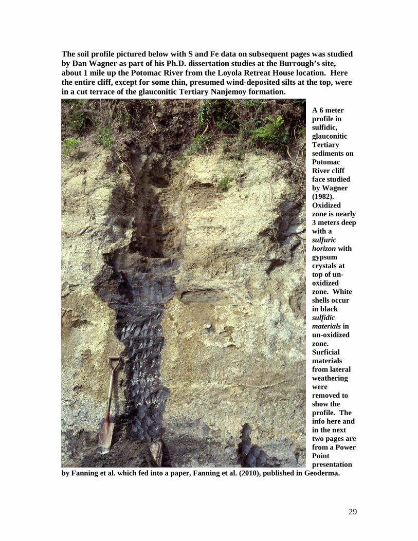
The soil profile pictured below with S and Fe data on subsequent pages was studied by Dan Wagner as part of his Ph.D. dissertation studies at the Burrough’s site, about 1 mile up the Potomac River from the Loyola Retreat House location. Here the entire cliff, except for some thin, presumed wind-deposited silts at the top, were in a cut terrace of the glauconitic Tertiary Nanjemoy formation.
A 6 meter profile in sulfidic, glauconitic Tertiary sediments on Potomac River cliff face studied by Wagner (1982). Oxidized zone is nearly 3 meters deep with a sulfuric horizon with gypsum crystals at top of un-oxidized zone. White shells occur in black sulfidic materials in un-oxidized zone. Surficial materials from lateral weathering were removed to show the profile. The info here and in the next two pages are from a Power Point presentation
by Fanning et al. which fed into a paper, Fanning et al. (2010), published in Geoderma.

30
Sulfur forms with depth for profile shown on previous page, after Wagner, Ph.D. dissertation, 1982. Pyrite is present only in un-oxidized zone. Jarosite is retained in post-active zone in lower part of 3m soil. J and soluble sulfate are present in un-oxidized zone because of post-sampling oxidation. Note change in depth scale below the 3.0 meter depth.
31
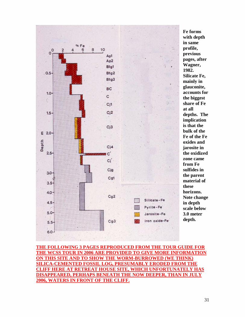
Fe forms with depth in same profile, previous pages, after Wagner, 1982. Silicate Fe, mainly in glauconite, accounts for the biggest share of Fe at all depths. The implication is that the bulk of the Fe of the Fe oxides and jarosite in the oxidized zone came from Fe sulfides in the parent material of these horizons. Note change in depth scale below 3.0 meter depth.
THE FOLLOWING 3 PAGES REPRODUCED FROM THE TOUR GUIDE FOR THE WCSS TOUR IN 2006 ARE PROVIDED TO GIVE MORE INFORMATION ON THIS SITE AND TO SHOW THE WORM-BURROWED (WE THINK) SILICA-CEMENTED FOSSIL LOG, PRESUMABLY ERODED FROM THE CLIFF HERE AT RETREAT HOUSE SITE, WHICH UNFORTUNATELY HAS DISAPPEARED, PERHAPS BENEATH THE NOW DEEPER, THAN IN JULY 2006, WATERS IN FRONT OF THE CLIFF.

32
EXTRA STOP ON JULY 7, CLIFF ON MARYLAND SHORE OF TIDAL POTOMAC RIVER AT LOYOLA RETREAT HOUSE THIS SECTION IS REPRODUCED FROM WCSS TOUR GUIDEBOOK, FANNING, 2006
This stop will be made in the evening of July 7 after we have checked in to our lodging at the Best Western LaPlata Inn and as we proceed on the way to our dinner stop for this night at Robertson’s Restaurant at Pope’s Creek on the shore of the tidal Potomac River about 10 miles southeast of LaPlata. The Retreat House stop is about a mile up river from the restaurant, which (the restaurant) is water’s edge. The Loyola Retreat House sits on a hill above the river and a trail to the river beach beneath a cliff on the river can be walked in about 5 minutes. It is a steep climb back, so those who don’t think they can walk down to the river and back in a few minutes should probably remain with the tour bus. It will be necessary to be quiet when we are close to the buildings of the retreat house as there will be a retreat going on and those in charge do not want us to disturb anyone. The cliff face here has many interesting (acid sulfate) and other weathering features. It was discovered for us by graduate student David Ruppert when he was participating in a retreat at the Retreat House and he went for a walk down to the river. We have been helped at this site as well by a former graduate student, Carol Gordon, who now works for the Charles County, MD, Soil Conservation District out of LaPlata. We are here in Charles County; LaPlata is the county seat. Fanning with students visited this site on a cold, windy Sunday afternoon near the end of February, 2006, when the pictures from this site on the following two pages were taken. One of the points of interest here is a thick Native American oyster shell kitchen midden that can be viewed from below, from the beach, up to where it is exposed at the top of the cliff – see picture X1 on the next page. There are such middens at many places along the tidal Potomac River, but this is one of the thickest that we have seen. It appears to have a buried soil surface with a thick A horizon (probably a buried anthropic epipedon) within it – that apparently was followed by another period of shell deposition. A few miles farther down the river, the small present-day village of Morgantown is built on an extensive midden on flat land just a little above sea level. The soils of that midden site have been studied as part of Master’s thesis research by former students Jim Luzader (1983) and Ian Kaufmann. Pictures of a soil

33
profile and a midden landscape when the soil was tilled from that site appear on page 67 in the Fanning and Fanning (1989) book.
Picture X1. Carol Gordon, (now, 2011, Carol Loopstra) who is a short person, holding a tiling spade (sharp shooter) standing on top of Native American oyster shell kitchen midden exposed on low cliff above tidal Potomac River just a short distance (50 meters) upriver from where the trail from the Loyola Retreat House reaches the river thru a creek valley to the right of where Carol is standing. This site will also afford an opportunity to view other parts of the cliff face to see the oxidized vs. un-oxidized parts of the soil-geologic column that are in marine sediments of Miocene (probably Calvert formation) and/or Eocene (probably Nanjemoy formation) age. We are hoping to get out to this site for a further look before we bring the tour group here. One of the interesting features that occurs in the cliff face are what we think are petrified (silicified) tree logs that have petrified worm burrows within them – see the picture, X2, on the following page. An acid sulfate weathering profile with its lower part in the un-oxidized Nanjemoy (Eocene) formation was studied on a 6 meter high cliff about a mile farther up river from the Retreat House cliff on the Mt. Air estate (Wagner, 1982). There the cliff was in a cut river terrace. At the Retreat

34
House site the land that the cliff is cut into is hilly. We would have liked the tour to have had the opportunity to visit the Mt. Air site that Wagner studied (see picture of that cliff in Figure 1.10 of Fanning and Fanning, 1989, page 10), however, we no longer have access to that site and it is also physically much more difficult to reach than this Retreat House site. At the Mt.Air cliff, macroscopic gypsum crystals where former calcium carbonate shells have been converted to gypsum by sulfuric acid, as well as jarosite and iron (hydr)oxides formed by acid sulfate weathering are to be seen in the base of the oxidized zone and in the actively sulfuricizing zone at the top of the un-oxidized zone.
Picture X2. What is interpreted to represent a worm burrowed log, where the burrows have been silicified, from the sediments near the base of the cliff on the Potomac River at the Loyola Retreat House. The surrounding sediments, which contain shells and shell casts are also apparently silicified. References: Fanning, D. S. and M. C. B. Fanning. 1989. Soil: Morphology, Genesis, and Classification. John Wiley and Sons, New York. Luzader, J. D. 1983. Characterization of soils developed in oyster shell middens in Maryland. M.S. Thesis. University of Maryland, College Park, MD. Wagner, D. P. 1982. Acid sulfate weathering in upland soils of the Maryland Coastal Plain. Ph.D. dissertation, University of Maryland, College Park, MD.

35
THE FOLLOWING PAGES ARE A NEW MANUSCRIPT FOR THIS GUIDEBOOK BY DARRIN LOWERY TO EXPLAIN THE NATIVE OYSTER-SHELL OYSTER-SHELL KITCHEN MIDDEN AT THIS SITE. A Brief Summary of the Popes Creek Midden Deposits along the Potomac River By Darrin L. Lowery, Ph.D. The Popes Creek area has a rich archaeological record. The archaeological record is indicated by the vast quantities of shell that are deposited across the landscape (see Figure 1). These shell deposits represent the refuse from thousands of prehistoric Native American meals that were discarded across the landscape over many millennia. The earliest shell midden debris along this stretch of the Potomac River dates to around 4,000 to 4,500 years ago. As expected, carbonized wood from ancient heaths (see Figure 1A), prehistoric ceramic fragments (see Figure 1B), stone tool chipping debris, damaged projectile points, and other materials have been found within the Popes Creek middens. The impressions on the ceramics (see Figure 2) provide evidence of other perishable materials (i.e., cordage, nets, and other fabrics) that have long since decayed and disappeared from the archaeological record. Some decorations observed on the ceramics show strong humanistic ties. A uniform gouged surface along the rims of some ceramic shards (see Figure 3) may have been created by scratching the surface of the wet clay with a finger nail and finger prints in the clay have also been noted on a few specimens. The artifacts shown in Figure 4 illustrate the long-term archaeological record associated with the Popes Creek area. The prehistoric ceramics include Mockley ware, which is an oyster shell-tempered type of vessel that was manufactured between 2,000 and 1,600 years ago. At that time, sea levels in the bay were 1.5 to 2 meters lower than present. Popes Creek ware, which was named for the Popes Creek site was manufactured between 2,200 and 2,500 years ago. Sea levels at that time were around 2.5 meters lower than present. Finally, Accokeek ware documents a human presence at the Popes Creek site between 2,500 and 2,700 years ago. During this era, sea levels in the Chesapeake Bay watershed would have been at least 3 meters lower than present. Between 1,800 and 2,500 years ago, prehistoric fossil sharks teeth belonging to the species Carcharodon carcharias were being collected by the prehistoric cultures living around the bay from the late Miocene deposits and being traded to the mound-building cultures in the Ohio Valley. Finally, the shape of the oysters throughout the stratified the Popes Creek midden deposits document the ancient salinity changes, the water clarity transformations, and the bottom conditions along the Potomac River over the past three thousand years. Between 1834 and 1840, Julius T. Ducatel, the State Geologist of Maryland, recorded many of the prehistoric shell middens in the Chesapeake Bay area as sources of calcium to be mined for agricultural purposes. Early reports indicate that some of the Popes Creek middens were over 6 meters thick before they were hauled away for farming or road construction activities. Like many middens around the Chesapeake, their size has been greatly reduced over the decades from mining and other agricultural activities. In the late 19th century, William Henry Holmes, a representative of the Smithsonian Institution, conducted the first systematic archaeological excavations at Popes Creek. His work along with later excavations documented the immensity and the long chronological

36
record associated with these grand prehistoric archaeological sites. The Popes Creek middens represent some of the largest prehistoric refuse piles in North America and they reflect interaction between humans and the former ecological bounty of the developing Chesapeake Bay.
Figure 1. Eroded Shell Midden with Prehistoric Refuse.
37
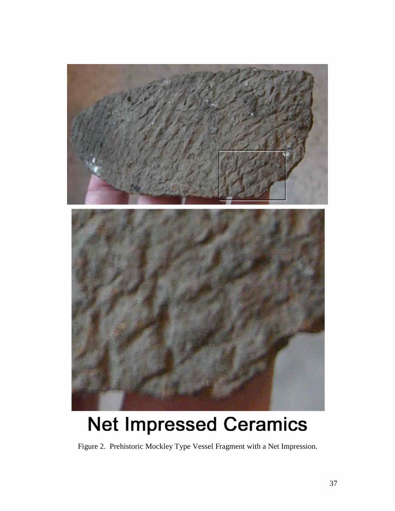
Figure 2. Prehistoric Mockley Type Vessel Fragment with a Net Impression.

38
Figure 3. Prehistoric Popes Creek Vessel Fragment with “Finger Nail” Incised Rim Decorations.

39
Figure 4. A Variety of Refuse from the Midden. This is the end of the Lowery paper
40
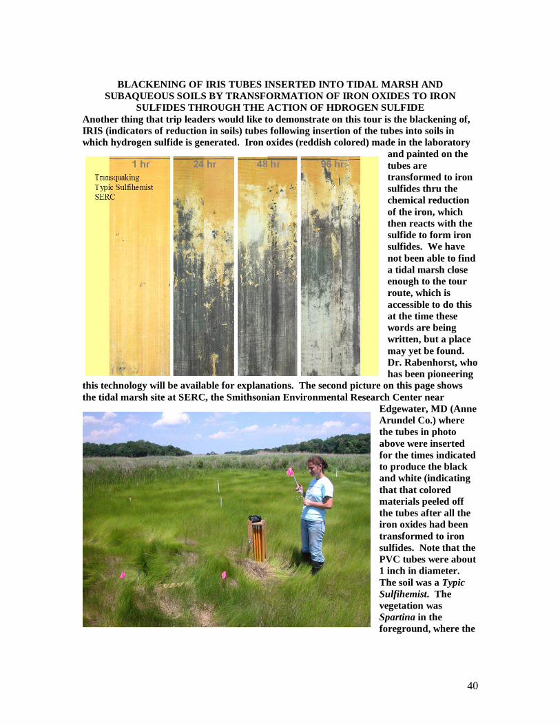
BLACKENING OF IRIS TUBES INSERTED INTO TIDAL MARSH AND
SUBAQUEOUS SOILS BY TRANSFORMATION OF IRON OXIDES TO IRON SULFIDES THROUGH THE ACTION OF HDROGEN SULFIDE
Another thing that trip leaders would like to demonstrate on this tour is the blackening of, IRIS (indicators of reduction in soils) tubes following insertion of the tubes into soils in which hydrogen sulfide is generated. Iron oxides (reddish colored) made in the laboratory
and painted on the tubes are transformed to iron sulfides thru the chemical reduction of the iron, which then reacts with the sulfide to form iron sulfides. We have not been able to find a tidal marsh close enough to the tour route, which is accessible to do this at the time these words are being written, but a place may yet be found. Dr. Rabenhorst, who has been pioneering
this technology will be available for explanations. The second picture on this page shows the tidal marsh site at SERC, the Smithsonian Environmental Research Center near
Edgewater, MD (Anne Arundel Co.) where the tubes in photo above were inserted for the times indicated to produce the black and white (indicating that that colored materials peeled off the tubes after all the iron oxides had been transformed to iron sulfides. Note that the PVC tubes were about 1 inch in diameter. The soil was a Typic Sulfihemist. The vegetation was Spartina in the foreground, where the
41
tubes were inserted and Phragmites in the background and forest on the hills surrounding the marsh. A reference to work by Rabenhorst and others pertaining to the measurement of sulfide concentrations in pore waters appears below. Reference: Rabenhorst, M. C., J. P. Megonigal, and J. Keller. 2010. Synthetic iron oxides for documenting sulfide in marsh porewater. Soil. Sci. Soc. Am. J. 74:1383-1388. Roadlog for MAPSS/VAPSS acid sulfate soils tour, Nov. 4, 2011. Start at SRAP, Stafford Regional Airport, which is STOP 1 0.6 mi. Turn right on Centerport Parkway. 2.6 mi. Cross Mt. View Road, continue on Centerport Parkway 3.8 mi. Take I-95 South exit, merge into 1-95S 8.5 mi. Pass VA Welcome Center. 10.0 mi. Take exit 130A for Rt. 3 East, merge into Rt. 3 East, and get into left hand lane. 10.8 mi. Turn left at 2nd light onto Mahone St., just before Kentucky Fried Chicken on left side of Rt. 3. 11.0 mi. Turn right onto Hays St. 11.2 mi. Turn left on Great Oaks Lane. 11.3 mi. Turn right on Hickory Court, stop vehicles along right side of Hickory Court Lane, Dismount vehicles, This is STOP 2. Group will split into two groups to visit reclaimed yard of Les Hazen at 1017 Hickory Court and the yard of family of Mandar Shirke at 1001 Hickory Court, on the NE corner of intersection of Great Oaks Lane and Hickory Court – this is the yard that folks in the neighborhood refer to as Iron Mountain, where the picture of Dr. Daniels which is on the cover of our guidebook was taken. This picture has become somewhat famous in the lore of acid sulfate soils, about which some comments will be made. The Shirke family is much interested to learn more about acid sulfate soils and Mr. Shirke may question us to learn more. Del Fanning just met him on Sunday, Oct. 30, 2011. After we reload the buses we will drive and turn around at the cul-de-sac by the Hazen residence and reverse our direction on Hickory Court. 11.5 mi. Turn left on Great Oaks Lane. 11.6 mi. Turn right on Century Oak Drive, which becomes Hays St. 11.8 mi. Turn left on Mahone St. 12.0 mi. At light turn left on Plank Road, which will be Rt. 3 East. Then stay on 3 East, don’t take business 3 14.0 mi. Be in right lane as Rt. 3 East makes a right turn – stay on 3 34.3 mi. Turn left on Rt. 301 to go northeast on 301 toward the Potomac River bridge to MD. 48.8 mi. You should now have crossed the Nice Bridge into MD, there is no toll in this direction. Continue on Rt. 301 to cross Rt. 257 at about 50.2 mi., and Rt. 234 at about 52.2 mi. – stay on Rt. 301.

42
54.8 mi. Turn left on Popes Creek Rd. Be careful, we will be crossing Rt. 301 south lane which carries fast-moving traffic. 55.9 mi. We pass Loyola Retreat House Rd. on the right, we will return and take this road on our return trip. 57.9 mi. We reach Captain Billy’s Crabhouse Restaurant, on the right, but we will park in the parking lot on the left side of Popes Creek Road. This is STOP 3, Lunch Stop. You may look at the tidal marsh with Phragmites reeds growing along its edge on left side of parking lot in the direction from which we arrive here. Unload vehicles and proceed into Captain Billy’s to eat, use bathroom facilities etc. After lunch we will reload vehicles and proceed back from whence we came to the Loyola Retreat House. 59.9 mi. Turn left on Loyola Retreat House Road. 60.7 mi. We will cross the bridge that was washed out by Hurrican Irene and was only put back so traffic could cross again on last Friday, Oct. 28. 61.0 mi. We reach the lower parking lot at the Retreat House. This is STOP 4. Unload vehicles and proceed down trail, be very careful, the hill down from the parking lot is steep and the dirt road/trail is gullied and difficult to traverse at the top part. Proceed following leaders to river to see Native American kitchen midden and other things as described in the tour guide. 62.0 mi. On our way back to SRAP, Turn left on Popes Creek Road 63.1 mi. Turn right onto Rt. 301 S. 69.3 mi. Nice Bridge over Potomac, Toll booths. Charge will be $4 for 2 axle vehicle, we could have saved $1 per vehicle had we come last week, the toll went up $1 for 2 axle vehicle this week. 83.4 mi. Turn right off 301 back onto Rt. 3 West to return to Fredericksburg. 102.6 mi. Stay left to follow Rt. 3 West, left turn here, don’t take business 3 that goes straight. Follow signs for I-95. 106 mi. Stay in right lane take exit from 3 onto I-95 north. 111.8 mi. Take exit 136, Centerport Pkwy. to SRAP. You’re on your own, it should be about 4.0 mi. back to airport parking lot. Thus total trip for the tour should be about 116 miles. We hope you had a good time and learned a lot about acid sulfate soils and a bit about Native American kitchen middens too!

43
ACKNOWLEDGEMENTS
Those of us who are in charge of running this tour for MAPSS and VAPSS and the University of Maryland and Virginia Tech have many to thank, undoubtedly we will miss some, please forgive. First, for permitting us to conduct our tour on their property, we owe a huge debt of gratitude to SRAP, Stafford Regional Airport, and especially to Airport Manager Ed Wallis for opening soil pits and his continued support for soil science and soil scientists For the opportunity to visit and study the cliff faces on the Potomac River at the Loyola Retreat House, Faulkner, MD we thank the Retreat House itself and those there, Barbara McDonald, Mr. Greer and others who were so helpful and kind to us. The bridge over the stream on the entry road, which got washed out by Hurricane Irene, got put back just in the knick of time to make our tour possible. We know it wasn’t fixed just for us, but we are extremely grateful that we were able to visit and study this wonderful place. We also thank the families of Les Hazen and Mandar Shirke at Great Oaks and that community in Fredericksburg for letting examine the soils by their homes to show aspects of acid sulfate soils and results of reclamation efforts and the need for more. Thanks also to the folks at Captain Billy’s Crabhouse at Popes Creek, Dottie Clemons and her efficient staff for collaborating to feed and host us for lunch. For help in gathering information and photos of the cliffs and for information about the soils and archeology at the Retreat House site and the surrounding area, we thank Dr. Daniel P. Wagner, Soil Consultant, Geo-Sci Consultants and MAPSS member, University Park, MD 20782, and Dr. Darrin Lowery, Department of Anthropology, National Museum of Natural History, Smithsonian Institution, as well as Department of Geography, University of Delaware. Although we haven’t met him yet, but for help with archeology information pertaining to the kitchen midden at the Retreat House site that we expect to receive when we visit there we also thank Dr. Torrey Rick of the Smithsonian Institution, and MAPSS President Dr. John Wah for coordinating with our archeology friends and encouraging us to consider the archeology aspects of soils as well as acid sulfate soils. And for their willingness to help, and soil monoliths still to be made, thanks to Margaret Boozer and her helpers at Red Dirt Studio, we expect her to be taking some pictures of us along the way. Finally we thank all attendees of this conference and field tour, be ye members of MAPSS or VAPSS or otherwise, and ourselves. And of ourselves, an especially big thanks and hugs from everyone for Sue Brown at VT for handling all the registration hazzles and everything else she did. Thank God for giving us the strength and energy to bring off this event. We hope the world will be better and more harmonious through wise and effective use of natural resources with which we have been so wonderfully bestowed, even sulfidic materials are beautiful, we just need to learn how to manage them better. Signed, Del Fanning, for Lee Daniels, Martin Rabenhorst and other members of MAPSS (Mid-Atlantic Association of Professional Soil Scientists) and VAPSS (Virginia Association of Soil Scientists) and our other sponsor of the conference and field trip, TCCSWCD (Tri-County-City Soil and Water Conservation District).