Transformation of Australia’s vegetated landscapes. Richard Thackway ACEAS Grand 2014
Upload
nguyenkhanhCategory
view
215download
0
Richard Thackway
ACEAS Seminar, UQ, Brisbane 15 December 2010
www.abare-brs.gov.au
Outline
• Drivers
• Big questions and the challenge
• Background
• This project and preliminary results
• Where to from here
• Conclusions
www.abare-brs.gov.au
Drivers for native veg condition info
• NRM policy and program design e.g. – Implementing guidelines for conservation and management of threatened
species EPBC ACT
– Reporting on the performance of investment e.g. changing LMP to
improve landscape connectivity
– Assessing land acquisitions for the National Reserve System
• Resource management e.g. – A measure of sustainable use and management (public/private)
• Monitoring and reporting and improvement e.g. – National, state & regional reporting e.g. SoE & SOFR
– Reporting 5 yearly outcomes Regional Forest Agreements 3

www.abare-brs.gov.au
The big questions
1. What happened in this landscape over time <200yrs?
2. How might these responses of native veg affect future land use options?
www.abare-brs.gov.au
0 1 2 3 4 5 6 7
1750 1800 1850 1900 1950 2000 2050
X, Y Tas Midlands
0 1 2 3 4 5 6 7
1750 1800 1850 1900 1950 2000 2050
X, Y Tas Midlands
0 1 2 3 4 5 6 7
1750 1800 1850 1900 1950 2000 2050
X, Y Tas Midlands
0
1
2
3
4
5
6
7
1750 1800 1850 1900 1950 2000 2050
X, Y Tas Midlands
0 1 2 3 4 5 6 7
1750 1800 1850 1900 1950 2000 2050
X, Y Tas Midlands
0 1 2 3 4 5 6 7
1750 1800 1850 1900 1950 2000 2050
X, Y Tas Midlands
0
2
4
6
1750 1800 1850 1900 1950 2000 2050
X, Y Tas Midlands
0
2
4
6
1750 1800 1850 1900 1950 2000 2050
X, Y Tas Midlands
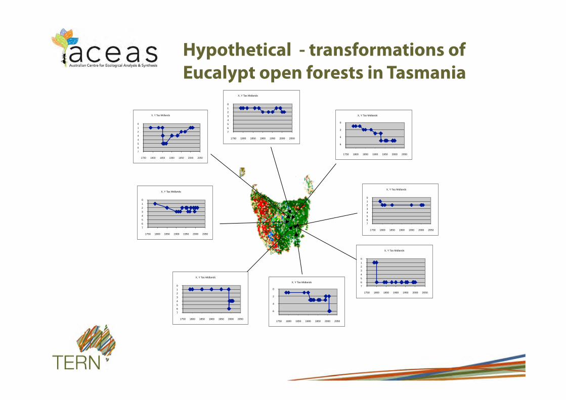
Hypothetical - transformations of
Eucalypt open forests in Tasmania

www.abare-brs.gov.au
1850-1900
1900-1950
2000-2010
Changes over time
1800-1850
1788-1800
1950-2000
The challenge

www.abare-brs.gov.au
Perceptions and misconceptions
7
• Except within the last 30 yrs there is no reliable vegetation condition data / info on changes over time
• Historical written observations of LU & LMP do not provide a reliable record changes in veg condition
• Study of native veg condition is a new and emerging discipline
• Detailed site-based ecological benchmarks are required to assess condition

www.abare-brs.gov.au
Historic use of vegetation condition info
High
Low
Low High
Influence of veg information
on public debate
Community’s willingness to act
Rainforests
Acacia shrublands Hummock Grasslands Tussock grasslands Other shrublands Leptospermum Heaths Chenopod shrublands
Savannah woodlands Eucalypt river red
gum forests
Mangroves
Eucalypt grassy woodlands
Tall wet eucalypt forests
Coastal heaths
Alpine grasslands
Acacia woodlands
Mallee shrublands
www.abare-brs.gov.au
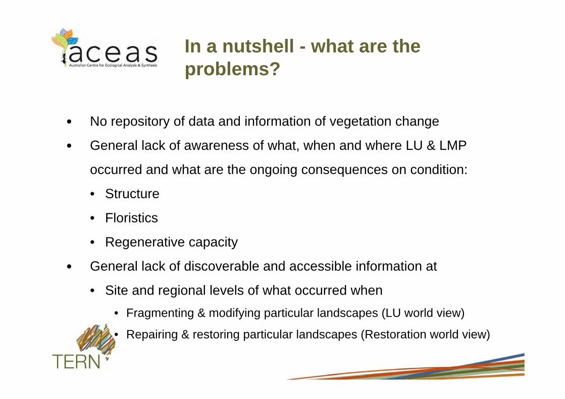
In a nutshell - what are the problems?
No repository of data and information of vegetation change
General lack of awareness of what, when and where LU & LMP
occurred and what are the ongoing consequences on condition:
• Structure
• Floristics
• Regenerative capacity
General lack of discoverable and accessible information at
• Site and regional levels of what occurred when • Fragmenting & modifying particular landscapes (LU world view)
• Repairing & restoring particular landscapes (Restoration world view)

www.abare-brs.gov.au
Assumptions
• Changes in LMP – result in predictable changes in structure, floristics & regen capacity – are adequately and reliably documented over time & are available/
accessible – can be used to simulate changes in vegetation condition – can be consistently and reliably differentiated from natural
environmental changes
• Ecological models and remote sensing can be used to spatially extend localised transformations to the broader landscape
www.abare-brs.gov.au
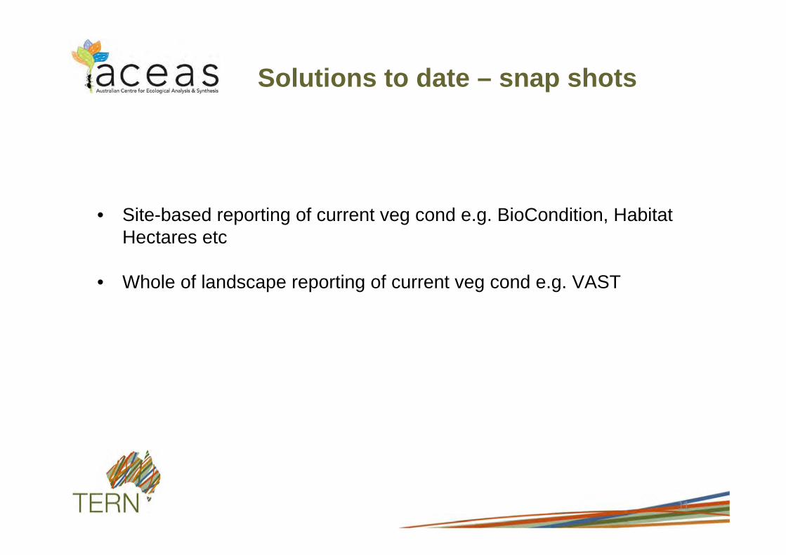
Solutions to date – snap shots
• Site-based reporting of current veg cond e.g. BioCondition, Habitat Hectares etc
• Whole of landscape reporting of current veg cond e.g. VAST
11
www.abare-brs.gov.au
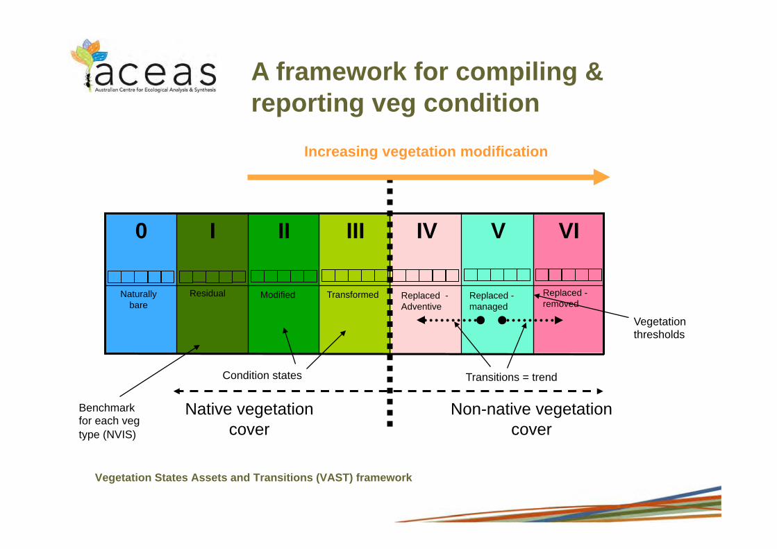
Vegetation States Assets and Transitions (VAST) framework
VI V IV III II I 0
Native vegetation cover
Non-native vegetation cover
Increasing vegetation modification
Transitions = trend
Vegetation thresholds
Benchmark for each veg type (NVIS)
A framework for compiling & reporting veg condition
Condition states
Residual Naturally bare
Modified Transformed Replaced -Adventive
Replaced - managed
Replaced - removed

www.abare-brs.gov.au 40 kms 0
Example: VAST Nandewar bioregion, NSW
Source: Westaway, Drielsma and Ferrier. (2004).
VAST classes I – Residual II – Modified III – Transformed IV – Replaced (Adventive) V – Replaced – managed VI – Replaced - removed
Increasing modification of veg structure, composition and regen capacity
VAST V & VI
VAST IIIb
VAST IIIa
VAST II
VAST I
O - 9
1O - 49
5O - 74
75 - 89
9O - 100
VAST
www.abare-brs.gov.au
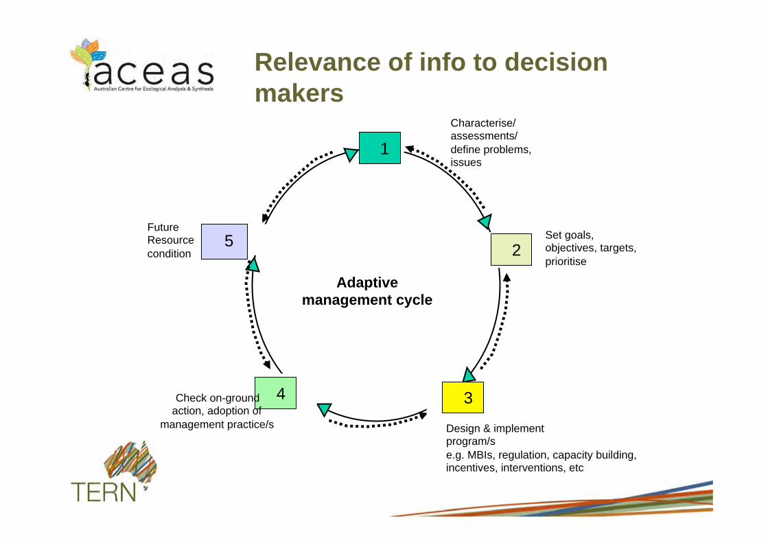
Relevance of info to decision makers
Adaptive management cycle
2Set goals, objectives, targets, prioritise
Characterise/ assessments/ define problems, issues
1
5Future Resource condition
4Check on-ground action, adoption of
management practice/s Design & implement program/s e.g. MBIs, regulation, capacity building, incentives, interventions, etc
3

www.abare-brs.gov.au
This project
• Develop an approach for simulating spatial and temporal responses of native vegetation to LMP
• Investigate opportunities for deriving trajectories of vegetation transformation
15

www.abare-brs.gov.au 16
Converting historical observations into ecological records
Where
When What

www.abare-brs.gov.au
Land management practices (LMP) = the how of land use:
• Remove life forms e.g. tree, shrub, grass e.g. push out, pull out, cut off and chemically treat
• Replace life forms e.g. tree, shrub, grass e.g. replant, rehabilitate, re-sow
• Manage health & vitality of life forms e.g. tree, shrub, grass e.g. prune, stake, slash, fertilise, graze
• Manage residues from life forms e.g. tree, shrub, grass e.g. burn grass, burn fine woody debris, bark, leaves
What are LMPs?

www.abare-brs.gov.au 18
Two types of data and information
Mainly aspatial - text-based e.g. • Land use and land management history • Environmental history • Ecological history • Other
Mainly spatial - maps and models incl. remotely images and GIS – ecological sources – land use and LMP sources – Geographical and historical sources – other
Older & more qualitative
More recent & more quantitative

www.abare-brs.gov.au
1962 1983 1986 1997 2004
Proof of concept
VAST states mapped between 1962 - 2004 Talaheni –250 ha southern tablelands New South Wales
Source: Thackway, Lesslie and Frakes (2006)
www.abare-brs.gov.au
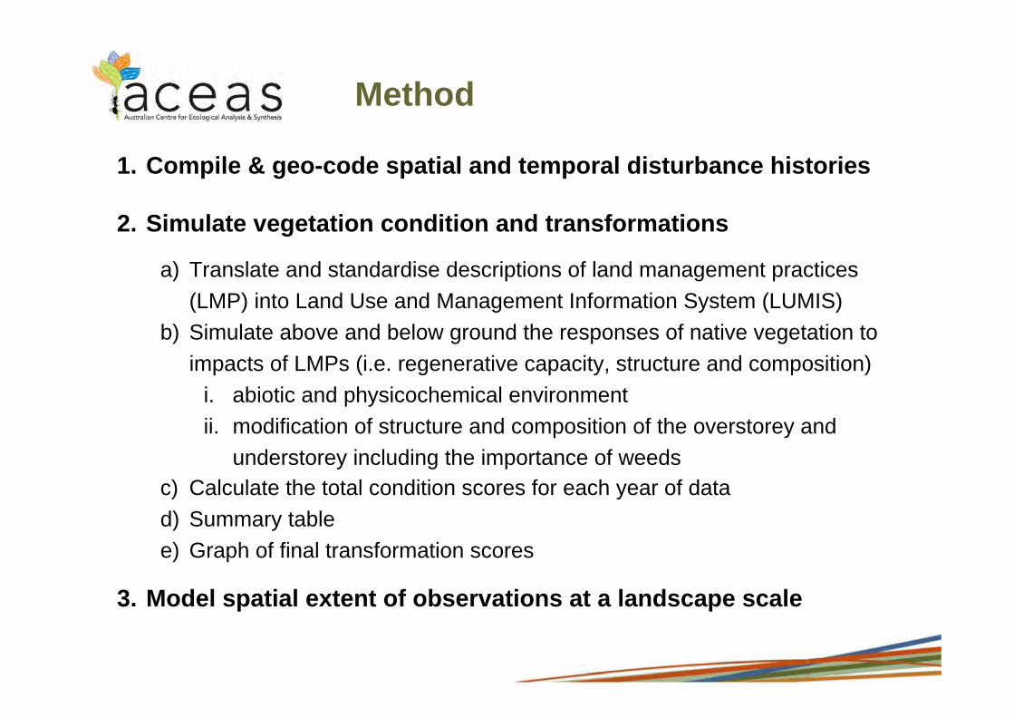
Method
1. Compile & geo-code spatial and temporal disturbance histories
2. Simulate vegetation condition and transformations
a) Translate and standardise descriptions of land management practices (LMP) into Land Use and Management Information System (LUMIS)
b) Simulate above and below ground the responses of native vegetation to impacts of LMPs (i.e. regenerative capacity, structure and composition)
i. abiotic and physicochemical environment ii. modification of structure and composition of the overstorey and
understorey including the importance of weeds c) Calculate the total condition scores for each year of data d) Summary table e) Graph of final transformation scores
3. Model spatial extent of observations at a landscape scale
www.abare-brs.gov.au
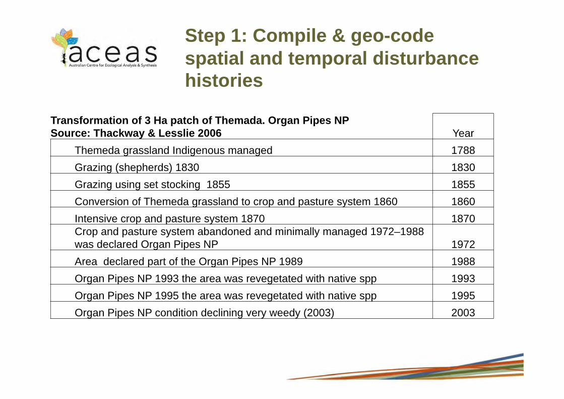
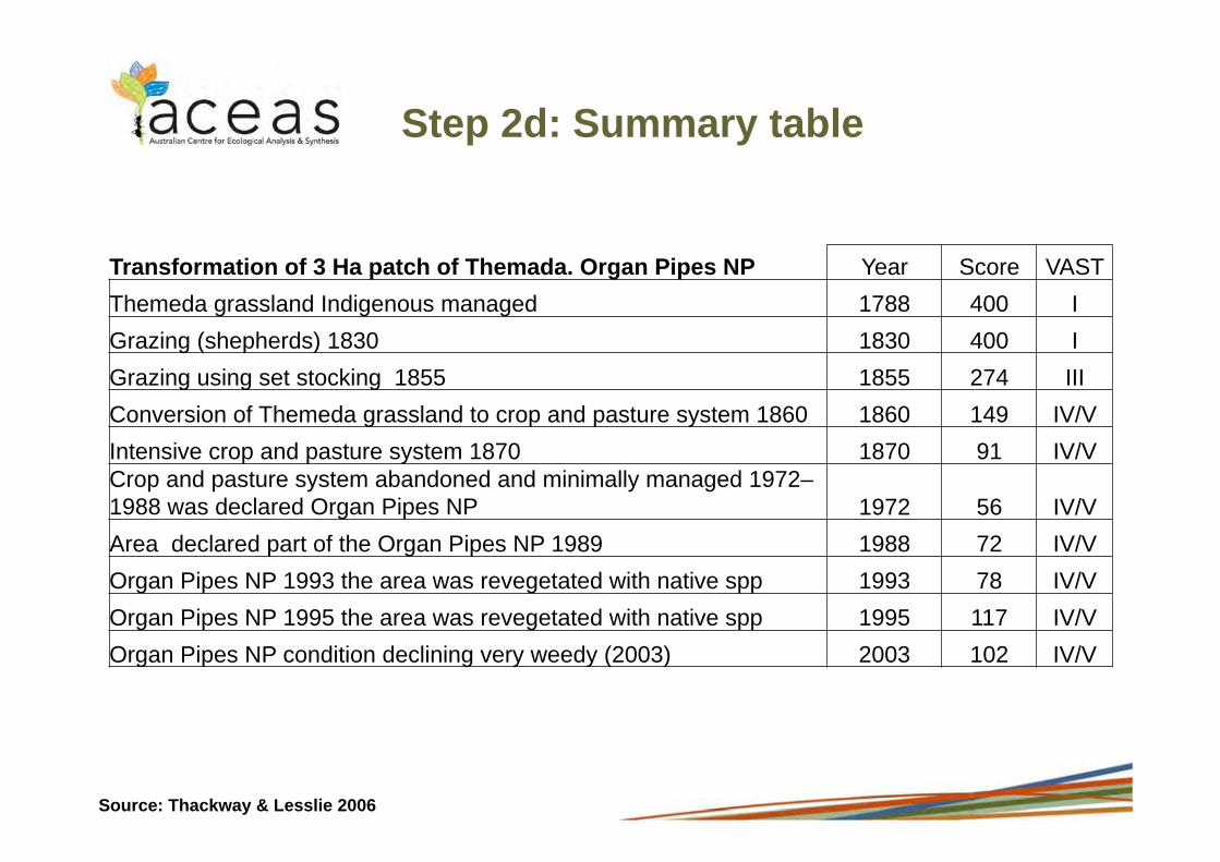
Transformation of 3 Ha patch of Themada. Organ Pipes NP Source: Thackway & Lesslie 2006 Year
Themeda grassland Indigenous managed 1788 Grazing (shepherds) 1830 1830 Grazing using set stocking 1855 1855 Conversion of Themeda grassland to crop and pasture system 1860 1860 Intensive crop and pasture system 1870 1870 Crop and pasture system abandoned and minimally managed 1972–1988 was declared Organ Pipes NP 1972 Area declared part of the Organ Pipes NP 1989 1988 Organ Pipes NP 1993 the area was revegetated with native spp 1993 Organ Pipes NP 1995 the area was revegetated with native spp 1995 Organ Pipes NP condition declining very weedy (2003) 2003
Step 1: Compile & geo-code spatial and temporal disturbance histories

www.abare-brs.gov.au 22
Land use codes
Land management practices focussed on: PLANTS_VEG (codes
1.n.n.n.n.) on ANIMALS (codes 2.n.n.n.n) on SOIL (codes 3.n.n.n.n)
on WATER (codes 4.n.n.n.n)
Year ALUM
classification
First LUMIS code
Second LUMIS code
Third LUMIS code
Forth LUMIS code
Fifth LUMIS code
1788 1.2.5
1830 2.1.0 1.3.1.4
1855 2.1.0 1.3.1.4
Step 2a: Translate and standardise LU & LMPs
www.abare-brs.gov.au
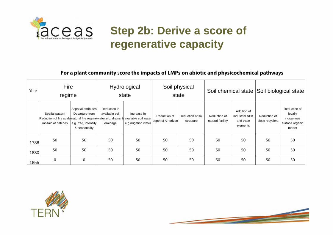
Step 2b: Derive a score of regenerative capacity
23
For a plant community score the impacts of LMPs on abiotic and physicochemical pathways
Year Fire
regime Hydrological
state Soil physical
state Soil chemical state Soil biological state
Spatial pattern Reduction of fire scale
mosaic of patches
Aspatial attributes Departure from
natural fire regime e.g. freq, intensity
& seasonality
Reduction in available soil
water e.g. drains & drainage
Increase in available soil water e.g irrigation water
Reduction of depth of A horizon
Reduction of soil structure
Reduction of natural fertility
Addition of industrial NPK
and trace elements
Reduction of biotic recyclers
Reduction of locally
indigenous surface organic
matter
1788
1830
1855

www.abare-brs.gov.au
Step 2b: Simulate responses of LMPs on structure and composition
24
Native vegetation extent Non-native vegetation extent >70%
unmodified 30-70%
unmodified 10-30%
unmodified <10%
unmodified (novel veg)
100% modified (replaced
production veg)
100% modified
(replaced no veg)
Vegetation structure
Upper
Lower
Vegetation composition
Upper
Lower
Structural 1. Height 2. Cover 3. Structural or age class diversity
www.abare-brs.gov.au
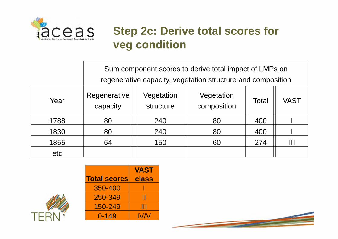
Step 2c: Derive total scores for veg condition
25
Sum component scores to derive total impact of LMPs on regenerative capacity, vegetation structure and composition
Year Regenerative
capacity Vegetation structure
Vegetation composition
Total VAST
1788 80 240 80 400 I 1830 80 240 80 400 I 1855 64 150 60 274 III etc
Total scores VAST class
350-400 I 250-349 II 150-249 III 0-149 IV/V
www.abare-brs.gov.au
Transformation of 3 Ha patch of Themada. Organ Pipes NP Year Score VAST Themeda grassland Indigenous managed 1788 400 I Grazing (shepherds) 1830 1830 400 I Grazing using set stocking 1855 1855 274 III Conversion of Themeda grassland to crop and pasture system 1860 1860 149 IV/V Intensive crop and pasture system 1870 1870 91 IV/V Crop and pasture system abandoned and minimally managed 1972–1988 was declared Organ Pipes NP 1972 56 IV/V Area declared part of the Organ Pipes NP 1989 1988 72 IV/V Organ Pipes NP 1993 the area was revegetated with native spp 1993 78 IV/V Organ Pipes NP 1995 the area was revegetated with native spp 1995 117 IV/V Organ Pipes NP condition declining very weedy (2003) 2003 102 IV/V
Step 2d: Summary table
Source: Thackway & Lesslie 2006
www.abare-brs.gov.au
Step 2e: Preliminary results for selected sites

www.abare-brs.gov.au
Talaheni, Murrumbateman, NSW

www.abare-brs.gov.au
Commenced restoration
toward native vegetation
Fencing and set stocking commenced
Overstorey cleared
Lightly grazing commenced
1962
Source: Fig 3 http://143.188.17.20/data/warehouse/brsShop/data/workshop_16_thackway.pdf
0
50
100
150
200
250
300
350
400
450
1750 1800 1850 1900 1950 2000 2050
Sco
re
Year
Transformations of grassy woodland Talaheni, NSW
- qualitative & quantitative data
VAST I
VAST II
VAST III
VAST IV/V

www.abare-brs.gov.au
Lower Cotter Catchment, ACT

www.abare-brs.gov.au
0
50
100
150
200
250
300
350
400
450
Sco
re
Year
Transformation of Themeda grassy woodland,
ACT – qualitative data

Organ Pipes NP, Vic

www.abare-brs.gov.au
0
50
100
150
200
250
300
350
400
450 S
core
Year
Transformation of 3 Ha patch of Themeda
grassland - Vic Basalt Plains

Eucalypt forest, South Brooman State Forest, NSW

www.abare-brs.gov.au
0
50
100
150
200
250
300
350
400
450
1750 1800 1850 1900 1950 2000 2050
Sco
re
Score
Transformation of Euc. Forest - Compartment 47,
South Brooman State Forest - quantative and qualitative data

www.abare-brs.gov.au
Where to from here?
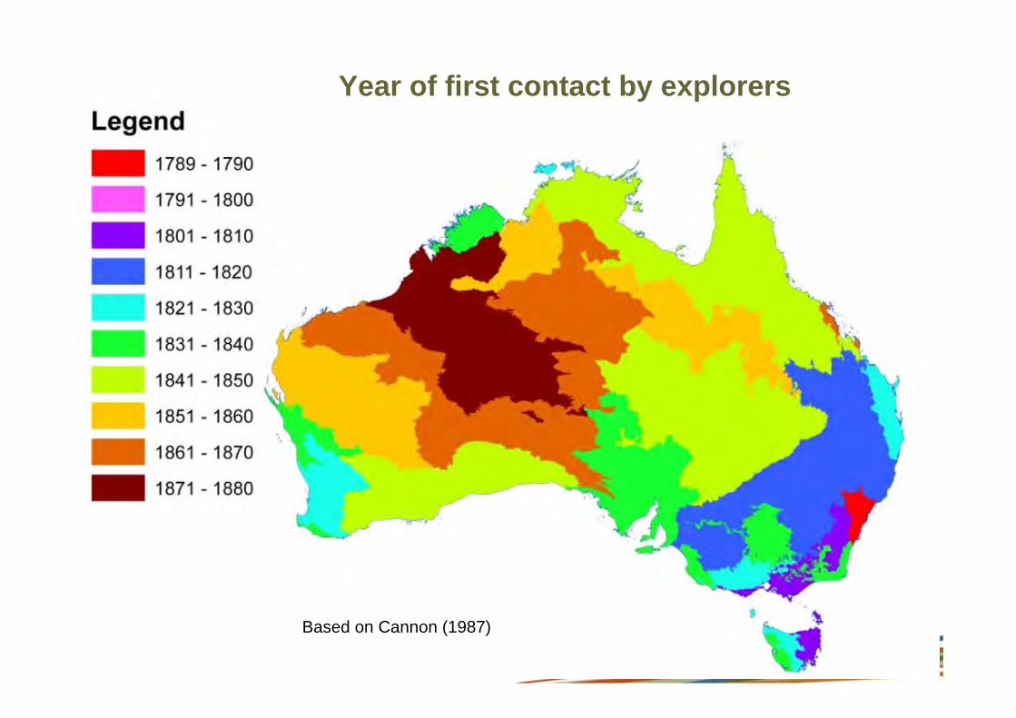
• Incorporate a regional context - first contact by explorers • Step 3: Model spatial extent of observations at a landscape scale
• Investigate ways of up-scaling sites to landscape scale using models and remote sensing
– Overstorey – Foliage projective cover – Height – Structural diversity
– Understorey – Height – Structural diversity – Ground cover
• Reference sites • More case studies ....?
www.abare-brs.gov.au
Based on Cannon (1987)
Year of first contact by explorers

www.abare-brs.gov.au
Step 3: Model landscape level transformations
Source: Sayre et al. (2009)
• Compiling model inputs for a national ecosystems mapping project (using GEOSS approach)
• TERN Auscover (2010 EIF proposal)
• CSIRO, ABARES, ANU and SEWPAC
• ~100m grid
• Help needed here with modelling
EIF (Education Investment Fund)

www.abare-brs.gov.au
Hei
ght
Crown /Foliage cover
Eucalyptus populnea (poplar box) woodland with emergent Angophora, Injune Qld.
Strata
LiDAR (1m cubes)
Step 3: Establish links with remote sensing

www.abare-brs.gov.au
Step 3: Establish links with remote sensing
Landsat MODIS
Burdekin catchments, Qld Green = Foliage Projective Cover Brown = Ground cover

www.abare-brs.gov.au
Step 3: Establish links with remote sensing
Dynamic Land Cover ‘view areas that show a sharp change in trend data in tussock grassland’
TERN, GA, ABARES, CSIRO
MODIS

www.abare-brs.gov.au
Step 3: Establish links with remote sensing
Dynamic Land Cover ‘view areas that show a sharp change in trend data in tussock grassland’
TERN, GA, ABARES, CSIRO
A B
MODIS
www.abare-brs.gov.au
Reference sites network
• Permanent sites showing relationships between LMP/s and veg condition
• Relevant sites include
• Forests
• Rangelands
• Other?
• Some work is needed to:
• Compile national network of sites (TERN)
• Validate relationships between LMP and veg condition

www.abare-brs.gov.au 44
Hypothetical - Interim maps of veg transformations

www.abare-brs.gov.au
• Preliminary results are promising
• Quantitative and qualitative info is used to simulate veg condition
• Access to site-based longitudinal datasets will help refine the approach
• Independent datasets are needed to validate relationships between the scores and the thresholds represented in the VAST classes
• This approach does not aim to simulate habitat or old growth
Conclusions

www.abare-brs.gov.au
Acknowledgements
• ACEAS-TERN is funding my sabbatical at the University of Queensland
• CSIRO Ecosystems Sciences, Canberra for hosting me as a visiting scientist
• ABARES, Greening Australia, Forestry NSW, CSIRO ES, John Ive for providing datasets
www.abare-brs.gov.au
Thank you