AccuWeather Enterprise Solutions White Paper Extraordinary ... · AccuWeather Enterprise Solutions...
8
Photo by Dick McGowan AccuWeather Enterprise Solutions White Paper Extraordinary Tornadoes and Preparedness Best Practices Presented By: Mike Smith / Senior Vice President, Chief Innovation Executive, Certified Consulting Meteorologist / AccuWeather Enterprise Solutions September 2013
Transcript of AccuWeather Enterprise Solutions White Paper Extraordinary ... · AccuWeather Enterprise Solutions...

Photo by Dick McGowan
AccuWeather Enterprise Solutions White Paper
Extraordinary Tornadoes and Preparedness Best Practices
Presented By: Mike Smith / Senior Vice President, Chief Innovation Executive, Certified Consulting Meteorologist / AccuWeather Enterprise Solutions
September 2013

One of the goals of AccuWeather Enterprise Solutions is to keep our clients and friends apprised of the latest developments in weather science, meteorological technology, and business best practices. A lot has changed since our last white paper in 2011, thus the need for an update.
I’m going to begin with the changes in weather science because that is the foundation on which both our services and best business practices rest.
/ Progress in Weather ScienceWeather science is moving forward rapidly. There are three major developments that affect our clientele:
Dual Polarization is being retrofitted to the existing NWS radars plus several new types of radar (such as the
CASA network being installed in Dallas-Ft. Worth) have it. Without going into the details, dual polarization allows
us to much more effectively differentiate between large hail and heavy rain. For example, the radar image below left from
eastern Kansas shows an area of high reflectivity in the conventional radar data (the type you would see on television).
Unfortunately, we don’t know for sure whether the conventional radar indicates very heavy rain or large hail.
With dual polarization, we are sure – the radar indicates large hail, and we are able to warn accordingly.
1
Conventional Radar Data Duel Polarization
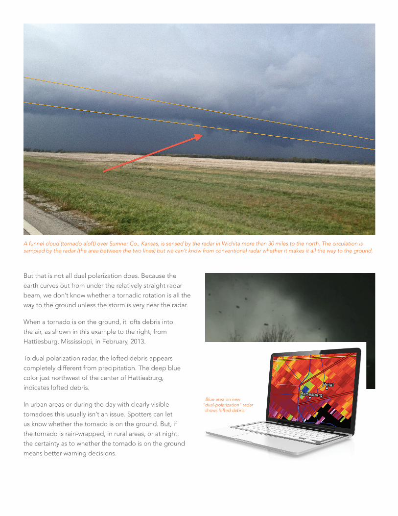
But that is not all dual polarization does. Because the
earth curves out from under the relatively straight radar
beam, we don’t know whether a tornadic rotation is all the
way to the ground unless the storm is very near the radar.
When a tornado is on the ground, it lofts debris into
the air, as shown in this example to the right, from
Hattiesburg, Mississippi, in February, 2013.
To dual polarization radar, the lofted debris appears
completely different from precipitation. The deep blue
color just northwest of the center of Hattiesburg,
indicates lofted debris.
In urban areas or during the day with clearly visible
tornadoes this usually isn’t an issue. Spotters can let
us know whether the tornado is on the ground. But, if
the tornado is rain-wrapped, in rural areas, or at night,
the certainty as to whether the tornado is on the ground
means better warning decisions.
A funnel cloud (tornado aloft) over Sumner Co., Kansas, is sensed by the radar in Wichita more than 30 miles to the north. The circulation is sampled by the radar (the area between the two lines) but we can’t know from conventional radar whether it makes it all the way to the ground.
Blue area on new “dual-polarization” radar
shows lofted debris

Terminal Doppler Weather Radar (TDWR) has
been around a while but the high-resolution data
available at one-minute intervals is new to private sector
meteorology. The wind sensing capability of TDWR is
four times greater than other Doppler weather radars.
That additional resolution helps us warn more accurately
of tornadoes, downbursts, and other small wind storms.
In addition to better wind data, Terminal Doppler Weather
Radars provide superior all-around data in a number of
major cities including New York, Philadelphia, Charlotte,
Orlando, West Palm Beach, Salt Lake City, and many others.
2
Mesoscale Modeling is a term coined by the
legendary Dr. Ted Fujita (for whom the Fujita Scale
is named). Mesoscale means “fine grained” – weather
features as small as 2.5 miles. Mesoscale models are
already providing us with superior forecasting data
for ice storms, blizzards, and thunderstorms.
AccuWeather Enterprise Solutions uses these scientific
breakthroughs and combines them with our storm warning
technology, our third-generation SmartWarn® System, which
is the envy of meteorology. What does this mean to you?
• The highest level of accuracy
• Timeliness that meets the agreed-upon goals
• Minimal false alarms
3
April 14, 2012, because the tornado is so close to the TDWR (deep purple circle at upper right), it could actually measure its swirling winds. The lighter purple oval shows the circulation around the tornado (known visually as a “wall cloud”).
The yellow arrow points to the (black pixel) calm center of the tornado. The darker blue area to the right of the arrow tip is winds of 150 mph. The small green area surrounded by red above the arrow’s tip is winds of 100 mph. This data assisted AccuWeather Enterprise Solutions in providing superior tornado warning accuracy that evening when compared with other sources.
Eight hours in advance, 70 to 75 mph are forecast for Washington, D.C. On schedule, the great derecho of June 29, 2012, swept across the city causing power interruptions for up to a week.

/ Best PracticesWe consult with scores of medium and large businesses from New York to San Diego and we learn a lot from listening to our clients. The suggestions below came from those consultations as well new meteorological and social science research into storm preparation and response.
As a result of both Hurricane Sandy and the multi-state
derecho (a storm that produced destructive winds from
west of Chicago to Washington, D.C. then east into the
Atlantic) of June 29, 2012, both electrical and telephone
service were lost over large geographic areas for extended
periods of time. Fortunately, there is a solution to insure your
company maintains communications when cell and landline
telephone service are lost in your area: a satellite phone.
The cost of satellite phones has come down dramatically
the last five years to where a number of models are well
below $1,000. Monthly fees have come down as well: you
can maintain a number with both voice and text capability
for less than $50 per month. This seems a reasonable
investment to maintain communications after violent weather,
a major geologic disaster, or manmade event occurs.
Tornado drills in the central U.S. are at least as important
as fire drills because the statistical odds of experiencing
a tornado are actually higher. To simulate the actual conditions,
turn off your lights during a drill as power may be lost in
advance of the tornado if the “real thing” occurs. If there
are any procedures (other than sheltering) that must occur
when a tornado approaches (such as shifting responsibility
to a different office) it is encouraged that those be practiced
during the drill. The more realistic, the better.
What can go wrong during a tornado warning? The question has been researched (Weather and Forecasting, October, 2010, p. 1412-1429):
• Person responsible for initiating warning response was off-site
• NOAA weather radio batteries were dead
• False reports of a tornado where none actually existed
• Conflicting information as to whether a tornado warning
was still in effect
• “Built-in” delay due to secondary relay of warning
information before action can be taken (i.e., warning
received in one department, second department
responsible for ordering action)
• Communicating an “all-clear” was impossible
(due to lack of power and/or communications)
I would add one more: Decision paralysis caused by too
many sources of information.
It seems logical to gather as many opinions as possible.
The problem with this approach is that it requires someone
to make a final decision from a myriad of sources (Doppler
radar display, sirens, weather radio television, commercial
radio, etc.) and that person likely lacks meteorological
expertise. Or, as I call it, someone has to “play meteorologist”
while the tornado or other storm is approaching.
While the “gather as much information approach” seems
logical, academic research shows it is ineffective.
Dr. Catherine Smith of East Carolina University, in her study
of school districts of North and South Carolina, learned
that the school districts that used one or two sources of
information made much better decisions as to whether
to call off school for a winter storm than those that used
six or more sources.
Social science also tells us that action will not be taken
on receipt of a National Weather Service tornado warning
until the warning is “confirmed” (c.f., Communication of
Emergency Public Warnings, Mileti and Sorensen, FEMA,
1990). This includes a process of determining the warning’s
relevance to the location in question, the level of threat
posed, et cetera. This process can be fraught with uncer-
tainty and inevitably delays action being taken.
What is the solution?
It is natural and profitable for companies to focus on their
core mission. Rather than worrying about the state of the
battery charge in a NOAA weather radio, it is far more effective
to outsource storm monitoring and warnings to specialists
and work with those specialists to effectively integrate
those warnings into your existing business processes.

/ Advantages of AccuWeather Enterprise Solutions’ SkyGuard® Service
Site-specificity. No more trying to figure out where the tornado is, which
way it is moving, and whether it will affect your location.
You receive a warning from AccuWeather only if your
location is going to be affected by the storm.
Advance preparation time. Your enterprise gets the time it needs to shelter
people and protect assets.
Clarity of communications. Whether it is a railroad’s operating rules, industry standards
or other communication requirements, our messaging fits
seamlessly into your mode of operation. No more trying to
translate wide-area “one size fits all” governmental warnings.
No unnecessary false alarms. Expensive false alarms, that call the credibility of your
organization’s warning system into question, are
minimized with SkyGuard.
Warnings created by true specialists. AccuWeather’s certified storm warning meteorologists
typically have eight times the amount of experience
handling tornadoes as local meteorologists (both
government and media). That level of expertise, combined
with our unique technology, leads to the highest quality
warnings the state-of-the-science will allow.
Communication with our meteorologists. Day or night, any day of the year, you may speak to the
meteorologist who is monitoring your location and who
issues the warnings for your location. Expert advice is
a phone call away.
SkyGuard takes all of the guesswork out of protecting your
assets and your people when dangerous weather presents
itself. SkyGuard warnings are received only when your
specific location is threatened and action is prescribed.
Auto Manufacturer
NWS Tornado Warnings
SkyGuard Tornado Warnings
Hrs. of Production Saved
Company A 203 25 131
Company B 54 14 31
Company C 133 14 93
/ How Good is SkyGuard?A thirty-two month study of America’s automobile industry documents the amazing value of SkyGuard. An unplanned shutdown is extremely expensive (i.e., half-painted cars ruined, stamping equipment must be cleaned, robotic computers reset, etc.).
This represents a cumulative saving of $15 million dollars via the elimination of lost production time to the U.S. auto industry during the period of study.

But it isn’t just about the bottom-line, it is about the safety
of your most important asset, your people.
This same manufacturer took a direct hit from a tornado
on February 5, 2008. Because their business continuity
department had set up a SkyGuard warning system, they
received twenty-two minutes of advance warning allowing
them to move 88 people into shelter where they stayed
as the plant collapsed around them (along with multi-ton
air conditioning equipment on the roof). Other than minor
cuts, which occurred while exiting the shelter through the
demolished plant, everyone was safe.
The company had rudimentary production back up just
13 days later!
This happy outcome would never have occurred using
the local government warnings. The first tornado warning
for the plant’s location was issued four minutes after the
tornado struck.
Regardless of your industry, your weather and storm
information should be clear and actionable so as to
protect your people, property and profits.
Heavy Equipment Manufacturer
NWS Tornado Warnings
SkyGuard Tornado Warnings
Hrs. of Production Saved
Company A 735 47 955
Similar results were achieved with a world-leading heavy equipment manufacturer with locations throughout the United States, Canada, and Mexico:
This represents a saving of more than $20 million via the elimination of lost production.
For more than a half-century, AccuWeather has provided award-winning services to business, industry, and government. Call us today. After all, the next storm may already be on the way.
Mike Smith is a board-certified consulting meteorologist and a Fellow of the American
Meteorological Society. He is founder of WeatherData, Inc. which became part of AccuWeather
in 2006 and where he now serves as Senior Vice President and Chief Innovation Executive
of AccuWeather Enterprise Solutions. Mike is the author of two books, When the Sirens Were
Silent and Warnings: The True Story of How Science Tamed the Weather. Mike is a frequent
speaker and author on both popular and technical weather-related topics. He has appeared
on The Discovery Channel, The History Channel, Fox News, and all of the major networks.

Call 814.235.8600 or email us at [email protected] to learn more about AccuWeather Enterprise Solutions.
AccuWeather.com/EnterpriseSolutions