
Accessing Hard Maps and Associated Digital … · Master of Science (Geographic ... Hastings thank...
76
Accessing Hard Maps and Associated Digital Components: A Case Study of the U.S. Library of the Marine Corps by Samantha J. Tucker A Thesis Presented to the Faculty of the USC Graduate School University of Southern California In Partial Fulfillment of the Requirements for the Degree Master of Science (Geographic Information Science and Technology) May 2017
-
Upload
duongthuan -
Category
Documents
-
view
219 -
download
0
Transcript of Accessing Hard Maps and Associated Digital … · Master of Science (Geographic ... Hastings thank...

Accessing Hard Maps and Associated Digital Components:
A Case Study of the U.S. Library of the Marine Corps
by
Samantha J. Tucker
A Thesis Presented to the
Faculty of the USC Graduate School
University of Southern California
In Partial Fulfillment of the
Requirements for the Degree
Master of Science
(Geographic Information Science and Technology)
May 2017

Copyright ® 2016 by Samantha J. Tucker

To Emma C. Tucker, my amazing wife and climbing partner

iv
Table of Contents
List of Figures ................................................................................................................................ vi
List of Tables ................................................................................................................................ vii
Acknowledgements ...................................................................................................................... viii
List of Abbreviations ..................................................................................................................... ix
Abstract .......................................................................................................................................... xi
Chapter 1 Introduction .................................................................................................................... 1
1.1 Current system: Hard copy map request ..............................................................................2
1.2 Maps .....................................................................................................................................3
1.3 Library of the Marine Corps ................................................................................................5
1.4 GIScience and maps .............................................................................................................8
Chapter 2 Literature Review ......................................................................................................... 10
2.1 Related studies ...................................................................................................................10
2.1.1. Library capabilities ..................................................................................................11
2.1.2. Library user access ...................................................................................................14
2.1.3. Metadata ...................................................................................................................15
2.1.4. Geospatial catalog and frameworks .........................................................................17
2.1.5. Definitions................................................................................................................19
2.1.6. Copyright .................................................................................................................19
2.1.7. Data types.................................................................................................................20
2.1.8. Scanning of hard maps .............................................................................................20
2.1.9. Georeferencing .........................................................................................................22
2.1.10. Extraction of vector features ..................................................................................23
2.2 Existing library databases ..................................................................................................24
2.2.1. Library cataloging examples ....................................................................................24
2.2.2. Entity-relationship model examples ........................................................................27
2.3 Database design process and evaluation framework..........................................................30
Chapter 3 Data and Methods......................................................................................................... 32
3.1 User communities ..............................................................................................................33
3.1.1. Marine/Dependent....................................................................................................34
3.1.2. Librarian (receives request and scanner) .................................................................34
3.1.3. IT personnel .............................................................................................................35

v
3.1.4. GIS analyst ...............................................................................................................35
3.2 Design principles ...............................................................................................................36
3.2.1. Task initiation ..........................................................................................................36
3.2.2. Scanning of hard map ..............................................................................................36
3.2.3. Metadata entry .........................................................................................................37
3.2.4. Vector feature creation .............................................................................................37
3.3 Spatial database design ......................................................................................................38
3.3.1. Overview of process ................................................................................................38
3.3.2. Spatial database principles .......................................................................................40
3.4 Collection of data ...............................................................................................................41
Chapter 4 Results .......................................................................................................................... 43
4.1 Spatial database ..................................................................................................................43
4.1.1. Spatial database structure .........................................................................................43
4.1.2. Attributes..................................................................................................................46
4.2 Evaluation of spatial database design ................................................................................51
4.2.1. Integrity constraints .................................................................................................51
4.2.2. Business rules...........................................................................................................53
4.2.3. Normal forms ...........................................................................................................53
4.2.4. Test data ...................................................................................................................55
4.3 Evaluation of process .........................................................................................................56
Chapter 5 Conclusion .................................................................................................................... 58
5.1 Objectives ..........................................................................................................................58
5.2 Advancing GIScience ........................................................................................................60
5.3 Future Work .......................................................................................................................61
References ..................................................................................................................................... 64

vi
List of Figures
Figure 1 Overview of ebRIM model with catalog standard extensions ........................................ 28
Figure 2 Outline of parallel processes registering an object ......................................................... 29
Figure 3 Example of a dataset incorporating ISO19115, NASA ECS, and FGDC metadata....... 30
Figure 4 Overview of proposed methodology .............................................................................. 32
Figure 5 Key stakeholders associated with process ...................................................................... 33
Figure 6 Overview of components and interactions ..................................................................... 39
Figure 7 Types of relationships possible within an entity-relationship model ............................. 41
Figure 8 Entity-relationship model displaying just objects for the spatial database..................... 44
Figure 9 Entity-relationship model expanded to include attributes for each object ..................... 48

vii
List of Tables
Table 1 Summary of software and staffing from five library universities .................................... 12
Table 2 Common metadata standards ........................................................................................... 16
Table 3 Observations of organizations with online map collections ............................................ 25
Table 4 Nine-stage GIS planning methodology............................................................................ 31
Table 5 Common principles from scanning a hard map ............................................................... 37
Table 6 Attributes that ignored the domain constraint.................................................................. 52
Table 7 Business rules for objects presented in Figure 9.............................................................. 54
Table 8 First, second and third rules for normal forms ................................................................. 54
Table 9 Objects that break the normal forms ................................................................................ 55
Table 10 Comments on how the designed process met the nine-stages ....................................... 57

viii
Acknowledgements
Dr. Kemp thank you for helping me find the “nugget”. Without finding the nugget, I would not
be seeing the light at the end of the tunnel for writing this thesis. Dr. Hastings thank you for
connecting me to databases and the wonderful world present beneath the deck. Dr. Chiang thank
you for the introduction to the connection between GIS and historical maps. Dr. Swift thank you
for the positive encouragements, early morning calls, and more positive encouragements. Each
professor I had at USC taught me about the different aspects of GIScience, and it is exciting to
know that it is so much more than a system.
Thank you to my wife who encourages me to be the best I can. Thank you to my family,
my military family, and friends for listening to my project and believing in me.

ix
List of Abbreviations
AK Actual key
ALA American Library Association
BCE Before Common Era
ebRIM e-business XML Registration Information Model
ECS NASA EOS Core System
eLibrary Electronic library
ENVI Environment for Visualizing Images
FGDC Federal Geographic Data Committee
FK Foreign key
GB Gigabyte
GIF Graphics interchange format
GIS Geographic information system
GISci Geographic information science
GRASS Geographic Resources Analysis Support System
ISO International Standards Organization
IT Information technology
JPEG Joint photographic experts group
m Meter
MAGIRT Map and Geospatial Information Round Table
MB Megabyte
NASA National Aeronautics and Space Administration
NYU New York University

x
OCR Optical character recognition
OCUL Ontario Council of University Libraries
OGC Open Geospatial Consortium
OWS Open Geospatial Consortium Web Services
PK Primary key
PNG Portable network graphic
ppi Pixels per inch
TIFF Tagged image file format
UDDI Universal Description, Discovery, and Integration
UNC University of North Carolina at Chapel Hill
URL Uniform resource locator
U.S. United States
USC University of Southern California
XML Extensible Markup Language
xi
Abstract
Maps provide information to researchers, as each map represents the environment from
the perspective of the creator, at a set point in time. Libraries act as sources of information for
researchers and can provide resources for users to locate, request, and receive maps. However,
each library has differing capacities for users to access maps, and that capacity can even differ
within the same organization. The United States (U.S.) Marine Corps is an example of an
organization that has libraries with differing levels of accessibility for users accessing maps. At
this time, remote users do not have access to hard, or paper maps, in the Library of the Marine
Corps located in Quantico, Virginia. Therefore the aim of this thesis is to design an innovative
process for remote users to access hard maps from the Library of the Marine Corps using digital
components. To design a suitable process and spatial database, this project focuses on how users
currently search and access hard maps and digital components from the Library of the Marine
Corps, what the metadata standards for geospatial data and cartography currently consist of,
common access capabilities of other libraries, and current practices for scanning, georeferencing,
and extracting vector features from hard maps. A detailed entity-relationship model illustrates an
efficient spatial database that can accompany the process, revealing the relationships between
different spatial objects involved in users locating, requesting, and receiving digitized versions of
hard maps and associated digital components from the Library of the Marine Corps. Finally, this
project evaluates the spatial database and process for integrity and suitability for the Library of
the Marine Corps. Other libraries housing important historical as well as current collections of
hard maps could use the results of this research.
1
Chapter 1 Introduction
Maps are important sources of information for showing how a map designer perceives the
environment at a specific point in time. This information provides researchers with information
about the past, which assists in understanding the present or making predictions about the future.
Maps are accessible from a variety of locations and libraries provide one of the easily accessible
points for researchers. Each library has different capacities for researchers locating, requesting,
and receiving a copy of a hard, or paper copy, map. Even libraries within the same organization
can have different capacities for user access. The Library of the Marine Corps, located in
Quantico, Virginia, is an organization with an extensive hard map collection and different levels
of accessibility for users requiring access to hard maps.
This project has two primary objectives to assist the Library of the Marine Corps with
allowing users to access versions of a hard map from a remote location. The first primary
objective is to design a spatial database capable of meeting the requirements of different users
and the library. To meet this objective, there are two secondary objectives. The first is to design a
robust spatial database that captures metadata about a hard map and allows for collecting,
storing, and downloading each hard map in various digital formats, such as an image or vector
file. The second objective is to structure the format of the spatial database as an electronic library
(eLibrary) allowing for terminology, spatial, and temporal searches of hard maps and digitized
components of maps. The second primary objective is to propose a process for utilizing the
spatial database. The process should explain how the spatial database interacts with the different
stages of a request for a copy of a hard map in a digital format. The process explains various
methodologies for scanning a hard map and how the spatial database archives obtained data
about a map. Finally, the process should explain the extraction methodologies for spatial data

2
and map features from a scanned map. Fulfilling these two primary objectives of a spatial
database and outline of processes for utilizing the database can assist the Library of the Marine
Corps in providing digital versions of hard maps to its remote users.
To meet these objectives and understand the importance of maps and the capacities of
this library the rest of this thesis is structured as follows: this chapter discusses how a user
currently accesses a hard map in the Library of the Marine Corps, why these maps are important,
why the Library of the Marine Corps is a suitable library for this study, and why hard maps are
important to geographic information science (GIScience). Chapter 2 contains a summary of
literature relevant to this study in the fields of library capabilities, metadata, definitions,
copyright, scanning, georegistering, and vector extraction. Chapter 3 proposes a streamlined
process to request and receive a copy of a hard map in digital format from the Library of the
Marine Corps, including the development of a spatial database model for archiving map features,
generating metadata about each map, and facilitating sharing digital versions of the library’s hard
maps. Chapter 4 proposes detailed procedures for users to request and receive a digital map, map
feature data, and metadata based on a hard map in the library’s holdings. Lastly, Chapter 5
provides a reflection on continuing communications with the Library of the Marine Corps and
recommendations for future implementations of the proposed process and spatial database and
their applicability to other libraries with important hard map collections not readily accessible to
remote users.
1.1 Current system: Hard copy map request
Users require access to libraries for research purposes and have various methods for
contacting, requesting, and receiving information from a library. Generally a library has a variety
of information available in different formats. The methods for contacting a library currently

3
include interacting at the library with a librarian, calling a library and speaking with a librarian,
emailing a library, and using a chat function available on a library’s website. Users also have
options to use a library’s website to search a catalog of holdings either remotely or within a
library’s premises. After a user locates the required document, there is an option for a user to
contact the library requesting the document. A user does not necessarily need to request the
document from the library if the location of the information is readily accessible, for example,
the call number in the library or a download option from the website. If a user is unable to
physically access the library, a user can contact a library and request to loan a library holding if
available. This option may not be feasible due to the age of a document or other lean restriction
for some documents in a given library so that a remote user may receive the document in a
different format compared to its original format. A hard map is an example of a document not
suitable for loaning between libraries due to its potential uniqueness and fragile nature,
regardless of age. This limitation requires the library to send a copy of the hard map to a remote
user in a different format. This format could differ between requests from users, as each user’s
purpose for the map may differ. Therefore, this thesis focuses on hard maps as the document
requested by users due to the varying formats required by users for research purposes.
1.2 Maps
Maps are a source of information displaying the relationship between the environment
and a map creator’s perspective at a set point in time. Brotton proposes that a map is “a graphic
representation that presents a spatial understanding of things, concepts, or events in the human
world” (2014, 7). This definition succinctly summarizes the intangible value of a map to a
researcher. It also specifies that a map is a graphic representation, but does not specify the
medium for that representation. Maps can occur in a variety of mediums including stone, animal

4
skin, paper, and digital. For example, one of the oldest maps present today displays the
interaction of a community and its environment in c.1500 BCE, carved onto stone, 2.3 by 4.6 m,
and situated in Capo Di Ponte, Valcamonica, Italy (Brotton 2014). Maps also display a variety of
subjects and perceptions of cardinality, the influence of religion, navigation, and politics
(Brotton 2014). Regardless of the medium or subject of a map, for example, the stone map from
Italy or a digital map created using ESRI’s ArcGIS Story Map, each can provide information for
research purposes (Esri 2016). This variety of mediums in which maps are available can affect
accessibility by users for research purposes. For example, access to a digital map can be through
a Web search or e-mail. Hard maps, unless already digitized, are restricted to the physical storage
location of the map.
Today, researchers can have ready access to hard maps due to digitization technology.
Unfortunately, many libraries have no standard requirements for handling the digitization of hard
maps. Due to financial costs associated with digitizing a hard map, duplication of effort of
having the same map both as a hard copy and a digital copy (Goodchild and Zhou 2003), time
involvement, and varying digital formats requested by users, it is often unrealistic to digitize
every hard map. Therefore, it is important to design a process and spatial database model that
facilitates searches for a hard map, provides options for several digital formats of a digitized hard
map, a method for digital data delivery to the requester, and a method that can validate hard map
digitization efforts. In narrowing the focus of this project, it was necessary to select a single
library for use as a case study since there are a variety of organizations that provide access to
hard maps including libraries and museums.

5
1.3 Library of the Marine Corps
A library suitable for this thesis project required two components: a vast collection of
historic as well as recent hard maps not currently digitized, and remote users not able to
physically access hard maps from the library. The Library of the Marine Corps is a suitable
library for this thesis as it has these two components. Currently, there are hard maps not stored in
a digital format located at Quantico, Virginia, while the Marine Corps has bases stationed around
the globe. Additionally, the Marine Corps requires Marines to continue their education
throughout their careers. This means that Marines require access to a library regardless of their
location, and potentially may require access to a hard map that is only located in Quantico,
Virginia. These components make the Library of the Marine Corps a highly suitable library for
designing a solution that facilitates Marines’ access to the library’s holdings.
U.S. Marines have the opportunity for continuing education in-residence (attend in
person) and through distance learning. For example, a Marine may receive orders for one year to
Command and Staff College at Quantico, Virginia and attend in-residence or to attend the
Command and Staff College Distance Education Program while stationed elsewhere attending to
other duties. When enrolled in a college or university, a Marine consults various source
documents, such as maps, to learn about past battles. For instance, while in-residence at
Command and Staff College, the students attend a staff ride (field trip) to the First Battle of Bull
Run, also known as Battle of First Manassas, fought during the Civil War in Prince William
County, Virginia. In preparation for this staff ride, students create a slide on a particular aspect of
the battle by consulting maps of the movement of the Confederates and Unionists, first-person
accounts by soldiers and generals, and interpretations by subject matter experts. The learning
materials for this staff ride are available from the Library of the Marine Corps and through public

6
Internet searches. Marines attending the Command and Staff College Distance Education
Program have a similar exercise except there is no staff ride component. Additionally, resources
come from the Marine Corps Community Services Library and public Internet searches. Since a
distance learning Marine is not located in Quantico, Virginia, the Marine does not have access to
the actual battle site or the Library of the Marine Corps. While the physical access to the battle
site is cost prohibitive for a distance learning Marine, access to the Library of the Marine Corps
could be facilitated. By changing the capacity of the Library of the Marine Corps to extend
services to distance learning Marines, the distance learning Marine is now only missing access to
the physical battle site in comparison to an in-residence Marine.
The access to items at each library differs greatly. The Library of the Marine Corps has
the greatest availability of library items, while the Marine Corps Community Services Libraries
offers the lowest level of access. This is because the Library of the Marine Corps is designated as
a research library, while the Marine Corps Community Services Library is a community library.
As previously stated, the disparity between access to library items and the requirement for a
Marine to continue education regardless of location is one of the primary criteria for the selection
of the Library of the Marine Corps for this thesis.
The Library of the Marine Corps provides access to holdings to Marines, other Service
Members, retirees, and family members. Its mission is to support “the Marine Corps University
and Marine Corps by providing comprehensive storage, retrieval, analysis, and distribution of
warfighting-related information” (Ramkey 2014, 2). This mission statement is important in the
context of this thesis for two reasons. Firstly the mission statement provides support for
implementing a system that improves retrieval and distribution of information, and secondly hard
maps are a source of warfighting-related information. As previously discussed, maps provide an

7
insight into a user’s perspective at a point in time, and a Marine can review information from a
map to make informed decisions about a future course of action.
The library has four different sections to help support the mission of the Library of the
Marine Corps. Only two sections, Archives and Special Collections and the Virtual Library,
pertain to this thesis as these sections contain hard maps. Both sections manage the storage,
digitization, and preservation of hard maps. The Archives and Special Collections have three
primary categories of information – personal papers, official Marine Corps records, and Marine
Corps University materials. Only personal papers and official Marine Corps records contain hard
maps. Currently, there is no access to these collections online as the Archives and Special
Collections branch building is undergoing maintenance (Marine Corps University 2016).
An example document published by the Archives and Special Collections section does
provide some guidance for accessing a collection. This document, about Desert Shield/Desert
Storm, explains the library’s referencing system, which is important when designing a suitable
methodology for improving access to hard maps and how users currently bring a personal laptop
and scanner to record information (Marine Corps Archives and Special Collections Branch
2010). As previously discussed, a Marine may be stationed outside Quantico, Virginia and not
have access to the Archives and Special Collections branch, so this method of physically visiting
the library and collecting materials is not suitable. The Virtual and Research Branches Collection
Development Committee selects, digitizes, and distributes materials to Marine Corps Community
Services Libraries (Ramkey 2014). However, this branch does not currently have any digitized
maps accessible online (Maslowski 2016). The Virtual and Archives and Special Collections are
key stakeholders to consider for implementing a process to serve users requesting access and
copies of hard maps.

8
1.4 GIScience and maps
As discussed, maps are an invaluable source of information and GIScience includes a
field of research dedicated to researching the extraction of information from hard and digital
maps. Other research fields that use information from maps or are concerned with the process of
digital information extraction include image processing, document analysis and recognition,
machine learning, data integration, and geoinformatics/digital cartography (Chiang, Leyk and
Knoblock 2014). Chiang et al. summarize the connection between geographic information
system (GIS) and maps succinctly: “Converting geographic features (e.g. place names) in map
images into a vector format is the first step for incorporating cartographic information into a
geographic information system (GIS)” (2016, 21). Chiang envisages that in the future all hard
maps and digitized components could be linked, which involves updating library databases,
improving search capabilities, and automating the scanning, georeferencing, and vector
extraction software (Chiang 2015). The aims of this project address the designing of a database
to link the digitization as well as the data integration process by completing the spatial database
design that can support both the cataloging of digital versions and archiving of information
retrieved from hard maps at the Library of the Marine Corps.
Beneficial results of incorporating cartographic information into GIS can be the
generation of gazetteers and the corresponding improvement of optical character recognition
(OCR) software (Chiang and Knoblock 2015). In such a project new words are added to a
gazetteer while processing multiple maps from different time periods creates additional
validation references (Yu, Luo and Chiang 2016). The Archives and Special Collections branch
of the Library of the Marine Corps contains historical maps that could contribute to historical

9
gazetteers, improving OCR capabilities for data retrieval from historical documents from
different eras.

10
Chapter 2 Literature Review
As part of this thesis work, review of two important areas of literature occurred to provide the
Library of the Marine Corps with a process that can assist remote users in accessing digital
versions of hard maps. First, a review happened on the literature and current practices for several
libraries which provide online access to maps to understand how users access spatial data in
these libraries, how digital versions of hard maps are stored, and how libraries provide requested
spatial data to library users. Second, a literature review revealed the technical processes of
scanning hard maps and extracting features from maps into data models. In the context of this
thesis, a data model is a vector file, such as a point or shape file containing spatial information
and descriptions about an object. By understanding the current procedures libraries use today for
handling digital versions of hard maps and the technology and software available for processing
hard maps, a conceptual model for the process and spatial database for the Library of the Marine
Corps was developed. The following sections provide a breakdown of these related studies,
including existing library databases, database design processes, and a database design evaluation
framework.
2.1 Related studies
To successfully design a spatial database and process for the Library of the Marine Corps
so users can request and download digitized hard maps and related components, a literature
review was conducted on a variety of related topics. The following topics as discussed in this
chapter, pertaining specifically to libraries, are library capabilities, library user access, metadata,
copyright, definitions, scanning, georeferencing, extraction of vector features, and data types.

11
2.1.1. Library capabilities
It is possible to determine a modern library’s capability for utilizing a spatial database
and process for providing digitized maps and features by reviewing the software and hardware,
staff expertise, and geospatial catalog design and frameworks required to support remote access.
These elements encompass confidentiality, agreements and licenses, data management policies,
archiving methods, and storage methods. As a part of this project, the knowledge of experts
including consortiums (Scaramozzino, et al. 2014, Forward, Leahey and Trimble 2015),
committees (Kollen, et al. 2013), and journals such as Journal of Map & Geography Libraries:
Advances in Geospatial Information, Collections & Archive, Code4Lib, and New Review of
Academic Librarianship were reviewed.
The first consortium evaluated currently consists of five university libraries, the
University of North Carolina at Chapel Hill (UNC), Texas A&M University, New York
University (NYU), North Carolina University, and California Polytechnic State University.
Scaramozzino et al. (2014) reviewed this consortium to learn how each library is transforming
supplying data from a single access point in a limited range of media formats to providing and
receiving data from multiple access points in a variety of formats. This review regarding
software, hardware, and staffing for each library provides insight for this project regarding
options for the Library of the Marine Corps to implement a system capable of handling
geospatial data and providing remote access to it. Table 1 summarizes the software and staffing
components from each library involved in that study. The discussion on hardware was limited to
locations of where users could access software on computers or what software users could
download onto personal computers, so is not included in Table 1 as part of the summary for
Scaramozzino et al. (2014) review.

12
Table 1 Summary of software and staffing from five library universities
University GIS Software Search and access
Software
Staffing
University of
North
Carolina at
Chapel Hill
Esri, Environment for
Visualizing Images
(ENVI), GME, Google
Earth, Geographic
Resources Analysis
Support System (GRASS),
QGIS, GeoDa, R,
statistical software
GIS Data Finder,
Andrew File System,
Endeca Information
Access Platform
Three full-time
librarians, two student
assistants with skills in
GIS and data service,
assistance from
information technology
services
Texas A&M
University
ArcGIS Java and Flash-based
Web-mapping services
Two professional, one
assistant, a GIS
coordinator, four to six
student assistants
New York
University
Esri ArcMap, ArcPad,
ArcIMS, ArcGIS Desktop,
GeoLytics, Google Earth,
Google Earth Pro, Simply
Map, Policy Map, Social
Explorer
Libguide,
OpenGeoportal.org
Staff from NYU
Libraries and
information technology
services
North
Carolina
University
GRASS, other open source
packages, ArcGIS
GIS Lookup database
designed by NC State
One data services
librarian
California
Polytechnic
State
University
ArcGIS 10.2, Google
Earth, SketchUp,
AutoCAD 2014,
MATLAB, SPSS, Adobe
Creative Suite
SLO Datafinder Web
site
Two full-time, one
half-time staff, three
assistants
Source: Scaramozzino, et al. 2014
Forward et al. (2015) provided information about another consortium, the Ontario
Council of University Libraries (OCUL), composed of 21 libraries. The authors’ reviewed the
consortium’s approach to handling metadata standards and utilizing a single online portal for
users to access geospatial information. OCUL implemented a self-designed Scholars Portal to
allow users access to spatial data from a Web site. This is a successful example of a group of
libraries successfully collaborating to creating their own software application, in this case, a
spatial data portal so that users can search for and access spatial data from a remote location

13
using the Internet. It is assumed that the collaboration to produce a single application was
economically preferable to each library attempting to create its own data portal. An added benefit
is the use of common metadata standards across 21 libraries which will streamline continuing
usage and maintenance of the data.
The Spatial Committee, formed by the American Library Association (ALA) Map and
Geospatial Information Round Table (MAGIRT) Geographic Technologies Committee,
interviewed a number of libraries to provide guidance to academic libraries using and
implementing spatial data catalogs (Kollen, et al. 2013). Kollen et al. (2013) summarized these
interviews to discuss common technologies libraries use for assisting users in searching for an
item. The common technologies for searching for an object within a system included databases
using PHP and MySQL, content management software, Geonetwork, ArcGIS Server, Dspace,
and Solr/Lucene. This variety of technologies used by different libraries reviewed in this study
indicates that there is no universal spatial data collection technology currently in use by research
libraries. Therefore, the spatial database or process could adapt to any of these technologies
depending on the software and staffing resources at the Library of the Marine Corps.
Durante and Hardy (2015) provide a case study using the Stanford libraries and the
implementation of a full-service repository for geospatial data. The Stanford libraries spatial data
infrastructure utilizes GeoHydra, Extensible Markup Language (XML), EarthWorks, and
GeoBlacklight technology. Hydra is a combination of Ruby language, Fedora repository,
Blacklight discovery platform, and Apache Solr search index. The GeoHydra, an open source
software, and EarthWorks are specific to the Stanford libraries. The Stanford libraries gather
information from a variety of sources, not just hard maps. While the objective of this project

14
involves only scanning hard maps for the Library of the Marine Corps, the processes used at the
Stanford libraries could be adapted for the Library of the Marine Corps.
Each of the libraries reviewed provide an online search tool using different software to
provide users with the ability to search and access geospatial data. UNC experienced difficulty
with users requesting access to geospatial data from external locations and changed from GIS
Data Finder and Andrew File System to the Endeca Information Access Platform for Libraries
(Scaramozzino, et al. 2014). The staffing at libraries seemed dependent on course requirements
and funding, and normally employed one GIS expert and one database expert (Scaramozzino, et
al. 2014). The reviews showed no universal method for libraries to provide search and access to
users regardless of software, hardware, or staffing (Durante and Hardy 2015, Forward, Leahey
and Trimble 2015, Scaramozzino, et al. 2014). Since there are a variety of software options for
libraries to construct a website for users to search and access geospatial data (Durante and Hardy
2015, Forward, Leahey and Trimble 2015, Scaramozzino, et al. 2014), it is important to
understand how existing users access libraries.
2.1.2. Library user access
For the purposes of this project, a user is a stakeholder that requires access to digitized
hard maps and associated digital components from the Library of the Marine Corps. This
relationship between the library and user is similar to the relationship between other libraries and
their users. This relationship involves a user identifying the collection, searching within the
collection for the required information (Goodchild and Zhou 2003), requesting the information,
and receiving the information. It is important to identify this approach as users have a variety of
methods available for searching data, including asking a librarian for assistance or using search
capabilities on a library’s website, which does not change the relationship between the library
15
and the user. It is important to understand each step for a user, as while the relationship remains
constant, the information shared within and between each stage can be different.
To determine how users access and search within libraries it is important to review
previous studies and surveys. Kollen et al. (2013) summarized a survey sent to academic libraries
by ALA MAGIRT and determined that users access information using search tools that are
alphabetical, topical, include basic and advanced text searches, spatial browsing, and have spatial
searching capabilities. Users typically access these search tools through Open Geospatial
Consortium (OGC) Web Services (OWS) using one of five standard interfaces: a web coverage
service, a web map service, a web feature service, a sensory planning service, and a catalog
service (Chen, et al. 2010). GIS users typically frame search requests around spatial, thematic,
and temporal themes rather than text-based searches (Ahonen-Rainio 2006). This means users
typically prefer a visual interface for locating and reviewing findings, rather than reviewing the
text of metadata (Ahonen-Rainio 2006). The design of the spatial database for this project,
therefore, should have the ability to interact with one of more of the standard search interfaces
used by the OGC OWS and provide a variety of search methods to users.
2.1.3. Metadata
Metadata standards provide uniformity for information about objects which translates
into attributes associated with an object in a database. The definition for metadata is “a set of
data that describes or gives information about other data” (Ahonen-Rainio 2006, 38). Metadata
can be external to an object as an accompanying file, or internal to the object, and is readable by
both human users and computer applications (Ahonen-Rainio 2006). In the context of this thesis,
an attribute is information that explains a certain part of an object, such as the attribute ‘author’
contains the name of the author that designed the hard map. It is important to maintain metadata

16
for each object separate from a user’s application, so an object is searchable within a catalog
with or without a web application (Durante and Hardy 2015), such as an online data portal. As
the objectives of this project focus on the U.S. Library of the Marine Corps and relevant spatial
components of the library's hard maps and proposed data models, the review considered
American metadata standards, standards related to library map cataloging standards, and
geospatial information standards.
The Federal Geographic Data Committee’s (FGDC’s) Content Standard for Digital
Geospatial Metadata (1998) and the International Standards Organization (ISO) are common
metadata standards for libraries (Kollen, et al. 2013, Chen, et al. 2010, Durante and Hardy 2015).
Table 2 is a compilation of common standards that could be considered in the construction of the
spatial database design. Due to the variety of standards listed in Table 2 and the varying purposes
of objects by users and organizations, there is no standard metadata template for American
libraries.
Table 2: Common metadata standards
Standard Purpose
19110 Geographic information – methodology for feature cataloging
19115-2 Geographic information – metadata – gridded imagery – part 2
19115 Geographic information - metadata
19119 Geographic information – services
19139 Geographic information – metadata- xml schema
implementation
19157 Geographic information – data quality
Source: Durante and Hardy 2015
Current map cataloging standards for libraries utilize the Resource and Description
Access and Functional Requirements for Bibliographic Records (Traill 2014). These two
documents assist in creating frameworks, such as the Library of Congress Bibliographic
Framework Initiative, which uses an XML for users to search for an object within a system

17
(Traill 2014). The generation and maintenance of metadata are both manual and automated.
Owners that generate the data or receivers that store the data can manually update metadata
information associated with an object, or computer programs can automatically retrieve the
information necessary for the metadata template of an object (Ahonen-Rainio 2006).
Additionally, text-based cataloging systems used by many libraries are different from
common metadata standards (Ahonen-Rainio 2006), meaning there is no simple integration
between the two standards, resulting in additional differences between organizations. While
metadata creates the frameworks for entering data, there is minimal guidance in the standards on
standard terminology for the entry fields of objects. Since there is no accepted standard, there
will be minimal metadata fields used in the designing of the spatial database. Future consultation
with the Library of the Marine Corps can of course add additional fields as required.
2.1.4. Geospatial catalog and frameworks
The structure of a geospatial catalog is the key to how a library can share information
with users. A geospatial catalog facilitates “sharing, discovery, retrieval, management of, and
access to large volumes of distributed geospatial resources” (Chen, et al. 2010, 411). In 2010, the
Spatial Data Committee established by the ALA and MAGIRT Geographic Technologies
Committee provided guidance to academic libraries on spatial data catalogs (Kollen, et al. 2013).
The OGC uses two primary models for cataloging digital resources, e-business XML
Registration Information Model (ebRIM) and Universal Description, Discovery, and Integration
(UDDI) (Chen, et al. 2010). The ebRIM uses an object-orientated approach which allows for
flexibility when integrating OWS, while the UDDI is a methodology intended for an
organization wanting to use OWS (Chen, et al. 2010). The design of the spatial database and
process for this project does not intend on using OWS for the Library of the Marine Corps to

18
provide access to digitized hard maps. Nevertheless, the ebRIM with its object-orientated design
is important in describing how an item is stored within the system and can be accessible to users.
A framework, such as the metadata lifecycle, supports the successful implementation and
maintenance of a geospatial catalog.
The metadata lifecycle explained by Kollen et al. (2013) describes a library’s
management of an item: collection, creation, storage, publication, discovery, retrieval, and access
and update. For this thesis, the hard map already exists within the library, so a review of the
collection step is unnecessary, whereas the rest of the steps in the metadata lifecycle require
review. This lifecycle allows users to locate an item within a library and is adaptable to different
libraries in terms of order and methodologies.
Durante and Hardy (2015) provide a framework focused more on geospatial data
compared to the metadata lifecycle with the aim of designing a “durable digital library assets,
delivering vector, raster, and georeferenced maps via a spatial data infrastructure, discovering
geospatial layers with a variety of applications and contexts, and curating geospatial data” (124).
The focus of this project is on access to hard maps, digitized hard maps, and associated vector
formats. According to Durante and Hardy (2015), observation is important to design a structure
capable of accommodating a variety of geospatial data formats.
In addition to a solid framework, it is important to include collection metadata during the
discovery stage (Goodchild and Zhou 2003). This component adds an upper level for users to
query before searching in detail for an item. Collection metadata is available to libraries in two
formats: inherent, meaning auto analysis, and contextual, meaning supplied by the creator.
Regardless of the selected collection metadata format, each item within a collection still requires
metadata so users are not sifting through large collections (Durante and Hardy 2015).

19
2.1.5. Definitions
To meet the objective of this project to design a robust spatial database that can locate
and request an object and remove duplicates, consistency is a key factor (Ahonen-Rainio 2006).
In 2008 the Library of Congress announced its Policy and Standards Divisions would develop a
genre/form thesaurus for cartography (Traill 2014). In 2010 the division published the Library of
Congress Genre/Form Terms for Library and Archival Materials that implemented multiple
headings for an object, rather than a single heading including multiple terms (Traill 2014). There
was no reference to hard maps in this publication. However, this change to headings for an object
is important to this study, as removing multiple terms from an attribute improves the integrity of
the database.
Hard maps also can be classified as rare materials and occur either as a map sheet or a
book. This means it is necessary to have definitions capable of incorporating both formats. In
2007 the Descriptive Cataloging of Rare Materials (Books) and Descriptive Cataloging of Rare
Materials (Cartographic) provided standards for these formats (Traill 2014). This project’s
spatial database design must take into consideration these dual source formats for hard maps.
2.1.6. Copyright
Libraries and source items within a library are subject to copyright terms and conditions.
These terms and conditions may restrict which users can access an item, whether an item can
leave the library premises, what the item can be used for or in, or how the item is to be
referenced. Additionally, the Library of the Marine Corps has different classifications that mean
only users with a certain level of clearance can access items. A spatial database for a library
should consider these terms and conditions during the design phase in consultation with the
library.

20
2.1.7. Data types
Maps are a compilation of data showing the designer’s perspective of the environment at
a single point in time. Data represents the environment either in a discrete or continuous format.
There is no correct format for data representing the environment, and the data format depends on
the user's intended use or subject. Discrete data is either a point, line, or area, while continuous
data is pixel based, forming a raster. The data format and software program used to create and
store the data determines the file format of the data. For example discrete data can use a shapefile
format (.shp) while continuous data can use an image file format, such as a portable network
graphic (PNG) transparent file (.png), joint photographic experts group (JPEG) raster format
(.jpg, .jpeg), tagged image file format (TIFF) (.tiff, .tif), and graphics interchange format (GIF)
transparent file (.gif).
The creation of a hard map is from discrete and continuous data. Often the background of
a hard map is continuous representing a surface, while areas of interest are discrete. For example,
a street map can user either a satellite image or elevation surface as background, while the roads,
houses, and county boundary areas are placed on top of the surface as a combination of points,
lines, and areas. Since the hard map is an image, it is continuous data and saved in one of the file
formats listed above for rasters. If required, a user can also digitize items from a hard map and
create discrete data.
2.1.8. Scanning of hard maps
The scanning of a hard map is important to this project for two reasons. The first reason
is that a user can receive a scanned map compared to a hard map. It is not always possible or
realistic to send a hard map to a user, as it may by priceless, have large dimensions, or not be a
suitable medium to mail. The second reason is that there is software available that can extract

21
features from scanned maps, such as points, lines, polygons, text and numbers, and symbols
(Chiang, Leyk and Knoblock 2014). By extracting digital features from hard maps, it is possible
to perform analyses of the features digitized from the hard map and combine these with
additional features from other hard maps, in order to perform new analyses (Chiang 2015). This
project’s literature review does not provide a detailed process on how to scan maps.
Nevertheless, the general process is important to understand, so that the process must be
described within the spatial database for scanning and capturing features and other information
form the map.
Stanford University Library’s Digital Production Group digitizes maps (Stanford
University Libraries 2016). This group uses a variety of equipment to scan a map, including a
robotic book-scanner, manual book-scanner, PhaseOne P65 and reproduction system, WideTek
wide format color scanner, flatbed scanner, and sheet feed scanner. Each piece of equipment has
different specifications regarding the level of resolution, with the robotic scanner having the
lowest resolution of 200 to 600 ppi, and the flatbed scanner having the highest maximum
resolution of 6400 ppi. One of the members of the group selects the suitable piece of scanning
equipment during the digitization process.
There are a number of steps required to digitize a map. The Stanford Library created a
video showing a typical method utilizing a camera for imaging a map. The author interpreted the
steps as follow from the video (Stanford University Libraries' Digitization Labs 2012):
1. Obtain resolution for image capture (based on the finest detail)
2. Adjust height of camera to capture necessary pixels
3. Take a picture of target used for quality insurance and software
4. For a map requiring multiple images, make sure the tiles overlap

22
5. Imaging software crops each tile
6. Upload tiles onto server for quality control
7. Stitch and photoshop tiles together with enhancement or embellishments
If the digitizer chose another piece of equipment to scan the hard map, then step 2 would
be adjusting the piece of equipment to ensure the correct resolution is captured for the image.
Other items that might change the process or require noting in the metadata for the scanned
image include the compression process and any aging artifacts if it is a historical map (Chiang,
Leyk and Knoblock 2014).
It is unknown what equipment the Library of the Marine Corps has for scanning maps.
Currently, the Library of the Marine Corps invites users to bring personal computers and
scanners to the Archives and Special Collections branch to scan documents (Marine Corps
Archives and Special Collections Branch 2010). This method was unsuitable for this project
since the author does not reside near the library location. Additional consultation is required with
the Library of the Marine Corps to determine current practices used by the library staff and
possibility of expansion of hardware to scan maps within the library.
2.1.9. Georeferencing
After a librarian or technician digitizes a hard map, the newly created image file needs to
be georeferenced so, the digital map works in a GIS. This means adding the appropriate
projection and coordinates to the raster. The degree of difficulty for georeferencing an image
depends on the clarity of features within the image, the scale of the image, the coverage of the
image (Campbell and Wayne 2011), and the published date of the original hard map (Yu, Luo
and Chiang 2016). If features are distinguishable within the image, the image occurs within one
projection, the area is large enough in the image to distinguish the area from other areas and was

23
recently published, then a GIS technician using a standard GIS software package could
georeference the image with a lesser degree of difficulty. For an image with any differences
related to these four criteria, the degree of difficulty increases.
This project’s objectives focus on the assumption that hard maps from the Archives and
Special Collections branch of the Library of the Marine Corps can be digitized. The hard maps
are likely to be hand drawn and from a different era. This means any digitized hard maps are
likely to be older maps; the features may be difficult to identify on the map, and the physical
scale of the image could change depending on the experience of the cartographer. Therefore, it is
likely to be a challenge to georeference any of the digitized images of older maps. To simplify
the goals proposed in this project, it is proposed that each map image be georeferenced with a
point for the general area of the map, rather than georeferencing the image itself. The spatial
database can also contain this simplified map location, datum, and projection as attributes
(Chiang, Leyk and Knoblock 2014). However, for the extraction of features from the digitized
image, the image must also be georeferenced. Therefore, additional research is required in the
processing of the digitized images to ensure each image is georeferenced with an acceptable
degree of error.
2.1.10. Extraction of vector features
The extraction of vector features from a georeferenced image is proposed as the final
stage in the process for this project. There are four options for processing a scanned map for
collecting vector features: (i) raster-to-vector conversion tool with minimum automation, (ii)
semi-automatic systems, (iii) fully automatic systems for specific map types, and (iv) fully or
semi-automatic systems for specific types of map features (Chiang, Leyk and Nazari, et al.
2016). Regardless of the processing system selected there are some challenges to extracting

24
vector features, in particular, labels, from historical maps. These challenges include artifacts
(noise, intersection of other text labels, and non-textual artifacts), unpredictable rotation and
orientation of text, and resolution of the image (Yu, Luo and Chiang 2016). Chiang, Leyk, and
Knoblock (2014) reviewed text recognition programs and associated challenges in detail. Some
of the information from this review is incorporated into the design of the spatial database for this
project, such as the resolution of the image, sampling spot size (blur), the bit depth of resulting
data, and brightness/contrast (Chiang, Leyk and Knoblock 2014).
2.2 Existing library databases
A review of other libraries cataloging standards and literature reviews of entity-
relationship models assisted in designing a spatial database capable of allowing users to locate,
request, and receive digitized versions of hard maps from the Library of the Marine Corps. The
author sent emails to libraries and Web sites that host digital maps to understand cataloging
standards and databases. Chen et al. (2010), Goodchild and Zhou (2003), and Durante and Hardy
(2015) provide models for cataloging standards. The Web sites of each organization, the
responses to the email, and the example models provide insight into how to design a spatial
database for this project.
2.2.1. Library cataloging examples
The organizations contacted to inform this project were either a research library or had a
Web site that hosted digital maps. Table 3 provides a list of the observed and contacted
organizations. From the six contacted organizations, the Library of Congress, Stanford Digital
Repository, History of War, and the Naval History and Heritage Command provided responses.
The responses are included in Table 3 along with observations from each organization's Web
site.

25
Table 3 Observations of organizations with online map collections
Name of System;
Organization
Function Model Data Collection
practice
Data dissemination
functionality
Perry-Castaneda
Library Map
Collection;
University of
Texas Libraries
Current and
historical
maps online.
Contains
public maps
from the
LoMC
Archives and
History
Division and
other military
services.
There are
70,000 maps
online and
250,000 in
print.
Unknown From non-
copyright sources.
Individual users
cannot request
digitization of a
map. A user can
email a request of
a suggestion for a
map requiring
digitization.
Scanning uses
two different
scanners with 400
to 800 dpi Older
maps are 150 to
200 dpi.
Maps are downloaded
via a hyperlink. Can
search via broad
categories. There is no
preview panel before
download. Within the
web browser, there is
an option to zoom. The
only format for saving
is JPEG.
Military History
Encyclopedia on
the Web; History
of War
Maps of
operations in
which
Marines have
participated
Access
database for
the articles,
pictures, and
maps
Unknown Able to search data via
two methods – indexes
(categories) and a
search box (categorized
via subject terms). If
accessing via the
gallery, then there are
thumbnails available
with hyperlinked
names.
Naval History
and Heritage
Command
Maps of
Marines
participation
in operations
OCLC
database or
Library of
Congress
system of
cataloging
and
classification
Unknown There is no direct
ability to search for
online map media.
Maps are associated
using topics.

26
Name of System;
Organization
Function Model Data Collection
practice
Data dissemination
functionality
Library of
Congress
17,400 map
collection
online with
some related
to Marine
Corps
operations.
Library of
Congress
Integrated
Library
System (LC
ILS) with an
upgrade to
Voyager
2000.1.3.
Database)
resides on a
Sun E10000
server
A variety of
sources including
maps, atlases,
reference works,
globes, relief
models, CDs, and
DVDs.
Accessed via online
map collections
website.
David Rumsey
Map Collection;
Cartography
Associates
71,000 maps
online from
16th through
21st century
with free
access to
high-
resolution
images
LUNA
Browser
A variety of
optical equipment
and digital
scanners. Images
are compressed
and viewable via
the internet.
It is possible to view
maps via a variety of
applications including
LUNA Browser,
Atlases, Georeferencer,
MapRank Search,
Google Earth, Google
Maps, Second Life, 3D
GIS, Insight Java
Client, and Ticker.
LUNA browser users
can search by keyword,
advanced search, or
category.
Stanford Digital
Repository
Provide
digital
collections
searchable
via Search
Works
Search
Works
catalog
Digitized by staff
or gathered
collections from
third parties.
Search Works via the
internet hosted by
Stanford University
Libraries. Unable to
view online maps,
unless they are
available for public
access.
As the Archives and Special Collections branch was not available for comment in the
time frame of this study, it is unknown what model and data collection practices the branch
currently uses. The Naval History and Heritage Command responded that it uses the Library of
Congress cataloging and classification system, which means the Library of the Marine Corps,

27
may conform to the same standards. The responses from each organization enforce the earlier
reviews from Section 2.1, that there is currently no standard methodology for designing a spatial
database, and that it depends on existing infrastructure, each organizations’ requirements, and
needs of the users.
2.2.2. Entity-relationship model examples
The literature review concerning different entity-relationship models applicable to spatial
databases that can serve academic or research libraries includes objects and attributes that may
be suitable for designing a spatial database. While each component is important in an entity-
relationship model, only some components apply to this project. Figure 1 is a simplified entity-
relationship model displaying objects and relationships. Objects relevant to this project’s spatial
database include ‘registry object’, ‘classification,' ‘classification scheme’, and ‘registry entry’.
These four components allow for identification of a hard map and for a user to search for the
hard map. The ‘extrinsic object’ is the search component of this model. This allows a user to
request an item. Another important item is the use of a unique identifier. This unique identifier
allows objects to be incorporated into the collection-level metadata (Goodchild and Zhou 2003),
allowing each object to belong to multiple classifications (Durante and Hardy 2015). By
allowing an object to occur within multiple classifications, this removes duplication and allows a
user greater search flexibility.
Another set of authors designed an overview for extracting data and metadata from an
object (Durante and Hardy 2015) . This methodology included processing data so users could
access information via an online data portal, which is different than the proposed methodology
for this project. The outline presented in Durante and Hardy’s (2015) paper does present an
alternate idea for the step of registering using two parallel processes as displayed in Figure 2.

28
Chen et al. (2010) provided a detailed perspective of the attributes associated with registering an
object integrating three metadata standards ISO19115, FGDC, and an additional standard NASA
EOS Core System (ECS). The NASA ECS is not under consideration for this project as it was
designed for NASAs remote sensing data. Figure 3 displays the interactions between three
different objects utilizing the different metadata standards; the core dataset, responsible
organization, and reference system.
Figure 1 Overview of ebRIM model with catalog standard extensions
Source: Chen et al. 2010, 414

29
Figure 2 Outline of parallel processes registering an object
Source: Durante and Hardy 2015, 133

30
Figure 3 Example of a dataset incorporating ISO19115, NASA ECS, and FGDC metadata
Source: Chen, et al. 2010, 414
2.3 Database design process and evaluation framework
To ensure the relationships between the different objects in the entity-relationship
diagram, there are three constraints to consider: (i) domain constraint, (ii) entity constraint, and
(iii) referential constraint (Yeung and Hall 2007). A domain constraint establishes permissible
value limits for each attribute. The domain is the smallest representative unit within each
attribute and cannot contain composite or multivalued attributes. The entity constraint is the use
of a primary key (PK) within each object and ensuring there are no null values. The referential
constraint involves the entry of new items within an object that has a foreign key (FK). The item
must first have a PK before a corresponding entry is created in a table where it has a FK,
otherwise the integrity of the database is compromised. The three constraints were considered

31
during the design phase of the spatial database for this project, and the resulting spatial database
was subsequently evaluated against the three constraints, described in detail in Chapter 4.
Evaluation of the process objective utilized the nine-stage GIS planning methodology
listed in Table 4 (Tomlinson 2013). By reviewing how this project’s process meets these nine-
stages it is possible to determine how the Library of the Marine Corps could receive the process
and spatial database and implement these items into the existing service system.
Table 4 Nine-stage GIS planning methodology
Stage Definition
1: Consider the strategic
purpose
Consider an organizations goals, objectives, mandates, and
management accountability for measuring success of this project.
2: Build the foundation Define planning and implementation stages to the organization and
receive funding for the planning stage. Organize a GIS team to plan
the design of the project.
3: Conduct a technology
seminar
Identify what the organization needs from GIS by hosting technology
seminars about the benefits of GIS and the planning process.
4: Describe the
information products
Identify tasks for stakeholders and design suitable information
products involving the method of construction of the product,
frequency of product outputs, input data, tolerance of error, and
benefits of a new product.
5: Consider the data
design
Define spatial data characteristics, data sources, data and technology
standards, and conversion and interoperability guidelines.
6: Choose a logical
database model
Select a database model that best represents the input data,
relationships, attributes, and behaviors.
7: Determine the system
requirements
Identify GIS workstations, software, communications bandwidth,
core capacity, and location of storage. Present findings to
organization.
8: Consider benefit-cost,
migration, and risk
analysis
Determine method for implementation and prepare a presentation for
organization using a benefit-cost analysis and risk factors.
9: Plan the
implementation
Write report addressing staffing and training, legacy hardware and
software, implementation schedule, managing changes, and benefit-
cost analysis.
Source: Tomlinson 2013
32
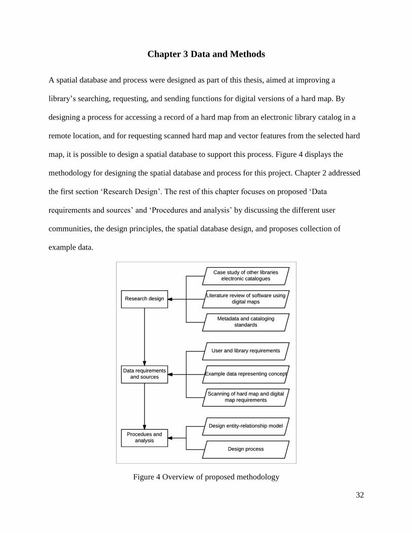
Chapter 3 Data and Methods
A spatial database and process were designed as part of this thesis, aimed at improving a
library’s searching, requesting, and sending functions for digital versions of a hard map. By
designing a process for accessing a record of a hard map from an electronic library catalog in a
remote location, and for requesting scanned hard map and vector features from the selected hard
map, it is possible to design a spatial database to support this process. Figure 4 displays the
methodology for designing the spatial database and process for this project. Chapter 2 addressed
the first section ‘Research Design’. The rest of this chapter focuses on proposed ‘Data
requirements and sources’ and ‘Procedures and analysis’ by discussing the different user
communities, the design principles, the spatial database design, and proposes collection of
example data.
Figure 4 Overview of proposed methodology
33
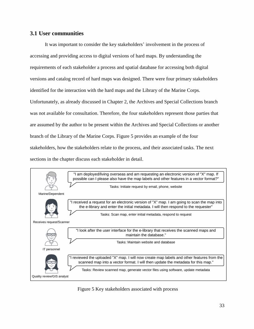
3.1 User communities
It was important to consider the key stakeholders’ involvement in the process of
accessing and providing access to digital versions of hard maps. By understanding the
requirements of each stakeholder a process and spatial database for accessing both digital
versions and catalog record of hard maps was designed. There were four primary stakeholders
identified for the interaction with the hard maps and the Library of the Marine Corps.
Unfortunately, as already discussed in Chapter 2, the Archives and Special Collections branch
was not available for consultation. Therefore, the four stakeholders represent those parties that
are assumed by the author to be present within the Archives and Special Collections or another
branch of the Library of the Marine Corps. Figure 5 provides an example of the four
stakeholders, how the stakeholders relate to the process, and their associated tasks. The next
sections in the chapter discuss each stakeholder in detail.
Figure 5 Key stakeholders associated with process

34
3.1.1. Marine/Dependent
The Marine or Marine’s dependent are the primary stakeholders, as these users are the
initiators and start the process of digitizing a hard map. Without a Marine or dependent
requesting a copy of a hard map or map features in a vector format, there is no initiator for
selecting a hard map for processing. As discussed in Chapter 2, it is probably not feasible to
process every hard map in a collection into a digital version due to money and time constraints of
a library and its staff. Therefore, the Marine automatically provides prioritization for the library
for processing hard maps in a collection into a raster and vector format.
It is necessary to capture information about each user, including best method of contact,
details about the requester, and level of clearance. As Marines are stationed or deployed in
various countries it is important to capture the best method of contact in order to enable
communication between the Marine and the library and to ensure delivery of the product(s). By
gathering other details about the requester, such as the Marines unit or level of education, this
information can be used for future analysis by the Library of the Marine Corps.
Also as discussed in Chapter 2, it is necessary to consider copyrights and classifications
of hard maps. By collecting the level of clearance of the requester, this information acts as a
mechanism for ensuring requesters can only access appropriate materials.
3.1.2. Librarian (receives request and scanner)
The librarian that receives the request from the initiator is the next key stakeholder in the
process. The librarian is a staff member, and for this project performs two tasks – responding to
the request and scanning and entering the initial metadata about the selected hard map.
Response to the request by the librarian validates the request of a user for a digital copy
of a hard map or map features in vector format. The librarian identifies the version of the hard

35
map in the collection and responds to the user. After the hard map is transformed into a raster or
vector format, the librarian responds to the user by providing or transmitting the final product(s)
to the user.
There are various hardware and software available for scanning hard maps as previously
discussed in Chapter 2. The skill level of the librarian for using the necessary hardware and
software depends on the resources available at the library. It is unknown what resources the
Library of the Marine Corps currently possesses for scanning a hard map, therefore, it is not
possible to identify the skill level. The librarian does require data entry skills to enter initial
metadata about the hard map into the spatial database.
3.1.3. IT personnel
The database and the user interface for the process of entering and managing the hard
map require information technology (IT) personnel. In the initial phase of creating a process for
converting hard maps to scanned and vector formats, the IT personal construct the spatial
database and the user interface. After the spatial database and user interface are operational, the
IT personnel maintains the software and hardware necessary for converting hard maps into
digital versions and the user interface for access.
3.1.4. GIS analyst
After the librarian scans in a copy of a hard map and creates a unique entry in the spatial
database, the GIS analyst uses appropriate software to contribute additional information from the
map. This additional information is in the format of vector features and can include labels, roads,
buildings, or other manmade features. As the GIS analyst creates each vector feature a
connection remains in the spatial database to the original hard map. This reduces duplication of
effort if a different user requests the same hard map and provides the ability in the future for
36
users to search for vector features via the user interface since the spatial database is now
populated with information from hard maps. The GIS analysist also accesses the user interface to
update the metadata with the necessary information for each digital version of the hard map.
3.2 Design principles
The spatial database for supporting the information and products gathered from scanning
a hard map involved four main processes: (i) initiation of the task, (ii) scanning of the hard map,
(iii) metadata entry, and (iv) creation of vector features. Taking into consideration the previous
section about key stakeholders this section continues the discussion about the principles behind
the design of the four processes.
3.2.1. Task initiation
Task initiation is a pivotal process that enables a central point for the process of scanning
a hard map. The task initiation incorporates factors such as details about the user requesting
information from the hard map, which librarian processes and scans the map, and details from
the existing library catalog about the hard map. Task initiation also allows the system to record a
start date, which allows management and administrators to track information regarding the
average time to process a request or the amount of time used by a staff member on a single
request.
3.2.2. Scanning of hard map
The scanning of a hard map depends on the technology and software available to an
organization. An organization such as the Stanford Library has multiple technologies for
scanning hard maps of various sizes and mediums. This means the collected data regarding the

37
scanning and processing of a hard map could be different, but there are some common principles
as listed in Table 5.
Table 5: Common principles from scanning a hard map
Principle Purpose
Resolution
Resolution is determined by the hardware or the personnel and
provides information about what the scanned map could be
used for in relation to visual displays and creation of vector
features.
Hardware
Recording the actual hardware used to scan the map provides
information to other users about the product. This could
provide insight into accuracy of the scanned map.
Error This provides information to the user of a scanned map any
errors that may have occurred during the scanning of the map.
Personnel
Knowing who scanned the map provides assistant in quality
reviews of items. This can also provide assistance in the level
of accuracy for a scanned map.
3.2.3. Metadata entry
There are two types of products that require data entry during the processing of a hard
map, firstly the hard map itself and secondly any raster or vector data formats. Depending on the
location of a library or the preferences of a library there is no worldwide industry standard for
the metadata for a hard map or a raster or vector data format. This means library data catalogs
could differ and flexibility is required in designing a spatial database to capture all necessary
information about the hard map and its additional products.
3.2.4. Vector feature creation
A GIS analyst can create a vector feature using suitable software. Discussed in Chapter 2,
there are different types of software for extracting vector features from a scanned hard map. It is
important to capture generic information about the feature extracted from the scanned image and
capture this information in the metadata. The data entry must also remain simple to ensure
consistency between different features and users. Similar to capturing information about the

38
scanned map is it important to capture the identification of the staff that generated the vector
data, the software used to create the data, the file format of the features, any errors encountered
during the processing, and other comments about the extracted information from the scanned
image. Capturing this information in the spatial database allows other users to locate and use the
vector features of a hard map.
3.3 Spatial database design
A spatial database supports the structure of a system that contains all the necessary
information for each object and the relationships between each object (Yeung and Hall 2007).
This type of database is recommended for this project because it is able to contain both spatial
information about an object and non-spatial descriptors. During the design of this spatial
database, it was important to document the stakeholders assumed to be involved in designing the
database structure, the guiding principles of the process, and the proposed functionality of the
user interface. This chapter already discussed the stakeholders and principles behind the process.
This section introduces a user interface for searching for a hard map and how the spatial database
interacts within that system. Then the basic principles behind constructing a spatial database are
proposed.
3.3.1. Overview of process
The process of a user requesting a scanned image of a hard map with features from the
map in a vector format is assumed to require a number of steps and interactions of different
components. Figure 6 provides a proposed overview of the different components involved in the
process. There are two main differences in the components as indicated by the two dashed
containers.

39
Figure 6 Overview of components and interactions
The container on the left is the user interface and is composed of three different parts.
The first provides the ability for a user to search for a hard map using keywords, or spatial or
temporal parameters. Once the user selects a hard map, the program initiates a request form and
sends it to the Library of the Marine Corps. Once the librarian receives the request and the scans
the map, the librarian enters the metadata for the scanned image using the librarian data entry
form. The GIS analyst also uses this form to enter in new vector data files or update the scanned
metadata.
The container on the right houses all the software and hardware that supports the user
interface. The web application scripting creates and maintains the website. The spatial database

40
contains the index and metadata information for the hard maps and is the primary focus of this
thesis. The digital storage is where the scanned maps and the vector features obtained from the
scanned image are stored. The design has the raster and vector files stored separately from the
spatial database as the file size of a scanned map can range from 200 MB to 2 GB (Rumsey,
2016). The greater the storage requirements of the database, the greater the requirement for the
amount of memory to index and search for items within the system. Therefore, to allow for
growth in the system and not grow the database such that it becomes inefficient, this project’s
design proposes the raster and vector files are stored separately.
3.3.2. Spatial database principles
The proposed design of the spatial database used an entity-relationship data model. The
entity-relationship model provided a workspace for visualizing the types of objects and
relationships between objects associated with a process. The workspace can be accessed and
understood by various stakeholders including the client, the database designer, the database
developer, and the end users (Yeung and Hall 2007). In this case, the proposed client is the
Library of the Marine Corps, the database designer is the author, the database developer is the IT
personnel, and the end user is the Marine or dependent. As the client is further engaged, the
entity-relationship model can later be adapted to meet the needs of the Library of the Marine
Corps and the users.
The actual entity-relationship model includes tables representing each object. An object
in the spatial database can represent a collection of items, such as people or books. Each object
has a list of attributes. Depending on the objects within the entity-relationship model there could
be geospatial feature classes, non-spatial tables, and spatial tables. The relationship between each
object is represented by line symbols with different markings as shown in Figure 7. It is possible

41
to have one-to-one, one-to-many, and many-to-many relationships with the additional rule of
mandatory or optional between tables within the spatial database.
Figure 7 Types of relationships possible within an entity-relationship model
3.4 Collection of data
This author consulted with the Library of the Marine Corps and reviewed necessary
documents from the Library of the Marine Corps website to understand the requirements of the
library and its users. The author requested example data from the Archives and Special
Collections branch of the Library of the Marine Corps. Due to the physical moving of the branch
at the time this research was conducted, the Archives and Special Collections was not available
for consultation.
As previously mentioned there are other libraries that service the Marine Corps which the
author consulted, including the Marine Corps Community Services Libraries at Camp Foster,
Okinawa, Japan to determine how remote users normally access hard maps from the Library of
the Marine Corps. The Camp Foster library currently provides remote users with the contact
details for the Library of the Marine Corps. The Camp Foster library only had three hard maps
within the collection, as the library has a community service focus rather than a research focus.

42
Therefore, the three maps, two of which were present in another Marine Corps library, were not
suitable as example data for this thesis.

43
Chapter 4 Results
To meet the objectives of this project, this chapter presents a spatial database design, evaluates
the spatial database design, and evaluates the process for making hard maps available to users,
Marines and dependents, proposed in Chapter 3. The first section of this chapter reveals the
proposed spatial database structure and provides a discussion about each object for interest. The
second section evaluates the spatial database design. The final section evaluates the process as
presented in Chapter 3.
4.1 Spatial database
The spatial database presented in Figure 8 is a combination of objects and relationships
between objects. Each object is comprised of attributes that contain additional information about
an object. This section discusses, in particular, the construction of the entity-relationship model
and the selected attributes for each object.
4.1.1. Spatial database structure
The objectives of this project informed the resulting structure for the spatial database.
Firstly, the spatial database needed to contain information that would allow a user to search for a
map using either a term, a category such as ‘civil war,' spatial information such as place name or
spatial coordinates, or temporal information. Secondly, the spatial database must facilitate access
to stored digital formats of a hard map, including the ability of a user to download the map
image. These two objectives appear straightforward and one object, such as a map record, could
be the primary object. However, a single object does not include information about who has
clearance to access maps, features on the map, or information about the staff responsible for

44
looking after the task of scanning and digitizing the hard map Figure 8 displays the objects
deemed to be required to meet the objectives of this project.
Figure 8 Entity-relationship model displaying just objects for the spatial database
The spatial database is comprised of seven different objects and nine relationships. These
objects are MAP, LIBRARY_OF_THE_MARINE_CORPS_CATALOG, TASK, USER,
PERSONNEL, and DIGITIZED COMPONENTS which contains DIGITAL_MAP and
DATA_MODEL. There are a variety of one-to-one and one-to-many relationships, both optional
and mandatory. The following paragraphs discuss the different objects and relationships present
in Figure 8.
The object MAP is pivotal in the database as this object contains information about the
hard map, links back to the Library of the Marine Corps catalog, is used by stakeholders, and
connects to digitized components such as vector features gleaned from the map. MAP has a one-
to-one relationship with the LIBRARY_OF_THE_MARINE_CORPS_CATALOG since each

45
hard map is unique in the catalog and the catalog only has one record of that hard map. The
relationship is mandatory between the hard map to the catalog since only some of the hard maps
in the Archives and Special Collections are recorded in the catalog. Each time a hard map is
involved in a task a unique record is created that links back to the catalog for the Library of the
Marine Corps.
The object TASK is the active component of the database that links a user and personnel
that work at the library to a hard map. A task must have only one user, but a user can initiate
multiple tasks. A staff member from the library receives the task and may simultaneously work
on multiple tasks. One hard map represents a single record in the object TASK. If the same hard
map requires additional digitized components, the same map can occur again within the object
TASK as a new record.
The object DIGITIZED COMPONENTS is a container for DIGITAL_MAP and
DATA_MODEL since these two components have the same one-to-many relationship with the
library staff. The container would not be present in the actual construction of the spatial
database. The use of the container simplifies the diagram to display two components that are
similar, reducing the number of lines required within the diagram. For example, the library staff
member has the same relationship with both digital components, represented by one line. The
relationship between the two objects means the personnel can work on one or multiple digitized
components, while a digitized component can only have one personnel assigned. The MAP has
two different relationships with the digitized components, which is why the relationship lines
continue inside the container to the corresponding objects. MAP to DIGITAL_MAP is a one-to-
one relationship because a user creates a task regarding a hard map and a library staff member
scans the hard map. Once a library staff member scans a map, other personnel can create

46
multiple data models. There is a one-to-many relationship between DIGITAL_MAP and
DATA_MODEL since is it important to record which scanned map the data models were made
from. As personnel can create multiple data models from a digitized version of a map, the hard
map needs a one-to-many relationship to capture all the different models. As stated in Chapter 1,
in the context of this thesis a data model is a vector file, such as a point or shape file containing
spatial information and descriptions about an object
The object PERSONNEL represents library staff members, such as the librarian, GIS
analyst, and IT personnel. As discussed in Chapter 3, each personnel have different capabilities
and tasks involved in the process of completing a request for a user for a digitized version of a
hard map. All personnel, regardless of ability, represent a single object as all personnel support
MAP, TASK, and DIGITIZED COMPONENTS.
The object USER is the last object and is different from PERSONNEL, as the user is the
object that initiates the task of processing a hard map into digitized components. The user only
has one relationship in the diagram, which is to tasks as previously discussed. A library staff
member is responsible for sending the digitized components to the user. It is not necessary to
directly link USER to MAP or DIGITIZED COMPONENTS, since this is not vital information
for either of these components. Instead, TASK captures this information if required by
administration.
4.1.2. Attributes
Each object contains additional information describing the individual item and revealing
the structure of the spatial database using different keys. Figure 9 expands on Figure 8 by
providing the details of the attributes for each object. Each object contains a PK which is a
unique identifier for different records. Since a PK is unique, the reference is not readily

47
recognizable by users and staff members, so an actual key (AK) is used instead. An AK is
normally a common name and recognizable by a user or staff member. In addition, some objects
contain one or more FKs which represent a relationship with another object. The name of the FK
in one object and the connecting PK in another object can differ as long as the content within the
cells is the same, since this is what connects two records in different objects. The remainder of
this section explains the different attributes within each object.
The object USER captures information regarding the person starting the request and
information necessary for creating a profile to access the system. The object has one PK, UserID,
and an AK UserName. The system automatically generates a unique PK. The user can create the
AK. The user interface requires the Password attribute so the user can access the user interface
for initiating tasks and searching for hard maps and digitized components. The Classification
attribute acts as a level of access ensuring a user only accesses items with a suitable level of
classification or clearance. The rest of the attributes consist of information contributed by the
user which can be used for future analyses of the users, such as level of schooling of users
collected by the ‘Education’ attribute.
The object TASK’s main purpose is to combine information from other objects, so there
are few attributes local to TASK. There is one PK, TaskID, a unique reference automatically
generated by the system. There are three FKs, UserID, PersonnelID, and MapID. These are also
unique references that link back to USER, PERSONNEL, and MAP respectively. The three
unique attributes to TASK are DateStart, DateEnd, and Request. The DateStart automatically
generates after a user submits a request. A library staff member enters the DateEnd in the same
format in which the user has received the requested product(s). The Request is a copy of the

48
comment from the user requesting digitization of a hard map and any other digitized components
such as vector features. This is a text field and created for tracking and archiving purposes.
Figure 9 Entity-relationship model expanded to include attributes for each object

49
The object PERSONNEL is similar to USER in that it has one PK, PersonnelID, and one
AK, UserName. The PK is a unique reference automatically generated by the system, and the
AK is a unique reference created by the staff member. The staff member also has a level of
classification which allows access to different classification documents. The other attributes
consist of basic information collected about the staff members.
The object MAP contains the largest number of attributes compared to the other objects
in the design. This is because MAP contains both metadata about the hard map and links to
digitized components of the hard map. MAP also meets one of the objectives of this project by
collecting information about search terms, geographic coordinates, and temporal information. A
user can later use these attributes in query searches. In regards to structure, MAP has one PK,
MapID, which is a unique reference automatically generated by the system. It has an AK,
MapName, that is recognizable by users and library staff members. This attribute does not have
to be unique, as there is the potential for different maps to have the same name. There are three
FKs, CatalogID, ScannedID, and VectorID that connect MAP to LIBRARY_OF_THE_
MARINE_CORPS_CATALOG, DIGITAL_MAP, and DATA_MODEL, respectively. The
ScannedID and VectorID are the same in both objects since the system automatically generates
these references. The format is not known at this time for the CatalogID. However the two must
be the same for the relationship to work between the objects.
The object LIBRARY_OF_THE_MARINE_CORPS_CATALOG represents the
Library of the Marine Corps catalog system. It is unknown what attributes the system presently
maintains or the structure of the existing database. When this information is obtained in the
future, the PK attribute name can be corrected and updated in MAP.

50
The object DIGITAL_MAP contains all the necessary information for when the hard map
is scanned including the location of the scanned map on the server. DIGITAL_MAP has one PK,
Scanned ID, that is a unique reference automatically generated by the system. It has one AK,
FileName, that is unique and created by the library staff member when the file is generated by
scanning the hard map. There is one FK, PersonnelID, linking PERSONNEL to
DIGITAL_MAP. This allows a record to be kept of the staff member that scanned the hard map
and entered in the information about the image file. If there are any discrepancies, the staff
member can be contacted by the library. Additionally, by using the PersonnelID, rather than the
UserName from PERSONNEL, the personal contact details of the staff member are protected.
The rest of the attributes contain information about the scanner used to scan the hard map, the
resolution of the image, the location of the file on the server, and any comments by the staff
member during the digitization process. This information helps mitigate errors in the future use
of this image.
The object DATA_MODEL is the next stage in processing the hard map after it is
scanned. DATA_MODEL contains one PK, VectorID, which is a unique reference automatically
generated by the system. Similar to DIGITAL_MAP it has an AK, FileName, that is a unique
identifier generated by a library staff member once the data model is created. DATA_MODEL
also has two FKs, PersonnelID, and ScannedID to create the relationships between
PERSONNEL and DIGITAL_MAP respectively. PersonnelID is acting in the same manner as in
DIGITAL_MAP providing a connection between the staff member that creates the various data
models and the staff member’s personnel information. The ScannedID links the digital map that
is used during the process of extraction of various data models. This information provides a
history for the data model and completes part of the metadata for the object. The rest of the

51
attributes pertain to the type of data model created, what feature was extracted from the scanned
map, what software was used to extract the feature, any errors encountered during the creation of
the data model, and where the item is located on the server.
4.2 Evaluation of spatial database design
When designing a spatial database, there are three basic principles that a designer should
adhere too: integrity constraints, business rules, and normal forms (Yeung and Hall 2007). These
constraints ensure a simple and non-duplicating design. These principles were mostly adhered to
when designing the spatial database to meet the objectives of this project. This result means the
entity-relationship model presented in Figure 9 can be adapted to the Library of the Marine
Corps software and system in the future. In addition, other organizations can adapt this entity-
relationship model using different software, since the model follows the basic principles. An
organization’s software does not have to contain spatial capabilities. As this database stores the
digitized components separately using a text or uniform resource locator (URL) field as a
reference, there is no requirement for software to project the scanned image or vector file.
4.2.1. Integrity constraints
This design of the spatial database addressed some of the integrity constraints since the
entity-relationship design only encompassed a portion of the constraints. In regards to the
domain constraint, the majority of attributes were designed for single-valued attributes except for
those listed in Table 6. After additional consultation with the stakeholder and software selected
for construction of the spatial database and user interface, the composite and multivalued entries
can be split into additional tables or ignored for simplicity purposes.

52
Table 6 Attributes that ignored the domain constraint
Object Attribute Composite/Multivalued description
MAP XY_Coordinate Contains a multivalued entry with both the X and Y coordinate.
To reduce the number of attributes in MAP these values were
kept together, but can be split into separate attributes during
construction of database.
MAP ContentTags A map could have more than one searchable tag associated with
it. Without access to example data it is unknown what the tags
could involve. This attribute could use a gazetteer for tags or
allow the librarian to enter tags. The first would remove
duplication, while the second method would require additional
rules when users search via content tags. This decision would be
decided in consultation with the stakeholder.
MAP Author Contains a composite in two forms. The first contains both the
first and last name of the author. The second is the possibility of
more than one author. The decision to create a separate table
with authors depends on the existing library catalog and
stakeholder preferences.
MAP MapSize Contains a multivalued entry with both the width and the height
of the hard map.
TASK Request Contains a composite entry as this is a copy of the text from the
user requesting digitization of a hard map. This attribute could
reference the hard map and the digitized components requested
by the user.
DIGITAL_
MAP
Resolution Contains the potential for a multivalued description if the height
and width are different for the pixels selected for scanning.
DIGITAL_
MAP
Error Contains a composite entry if text has references to multiple
errors.
DIGITAL_
MAP
Comment Contains the potential for a composite entry if the personnel
enter a comment.
DIGITAL_
MAP
Hardware Contains the potential for a composite entry if multiple hardware
are used during digitization.
DATA_
MODEL
Error Contains a composite entry if text has references to multiple
errors.
DATA_
MODEL
Comment Contains the potential for a composite entry if the personnel
enter a comment.
DATA_
MODEL
Software Contains the potential for a composite entry if multiple software
are used during digitization.
As discussed in section 4.1.2, each object has one PK that is a unique reference
automatically generated by the system. The automatic generation of a PK ensures there are no
null values and stops a library staff member from accidentally creating a record without a PK.
53
This ensures the entity constraint and removes the additional rule during construction of the
database that the PK is not null.
The referential constraint is unable to be enforced during the entity-relationship design
stage. Each object discussed in section 4.1 has a PK and an FK with the same attribute name to
help maintain the relationships between each object. The only relationship FK attribute that is
unclear is the relationship between MAP and LIBRARY_OF_THE_MARINE_CORPS_
CATALOG since it is unknown at this time how that attribute is currently referenced in the
library’s catalog.
4.2.2. Business rules
Business rules continue to enforce the relationships between objects. The detail about the
rule for each relationship is not explicit in Figure 9, however, it is possible to determine which
relationships are mandatory and which are optional from the symbols in Figure 7. Table 7
explains in detail the business rules between the objects in Figure 9.
4.2.3. Normal forms
Normal forms are the next level of rules to ensure the integrity of the database. Normal
forms are concerned with the relationships between attributes within an object. There are three
rules, as presented in Table 8 that an object must meet to be in normal form. Consideration
during the design of the spatial database included maintaining normal form. The final spatial
database design unsuccessfully maintained normal form, as listed in Table 9. The breaking of
normal form within the spatial design was a decision by the author and additional consultation
with the client is required to fix any deviations from normal form.

54
Table 7 Business rules for objects presented in Figure 9
Objects Business rule
USER and TASK A task can only be initiated when a user makes a request
A user can make multiple requests
PERSONNEL and TASK A staff member must be assigned to a task at all times
A staff member can be assigned to multiple tasks
TASK and MAP A task must have a hard map
The same map can be assigned to multiple tasks
MAP and LIBRARY_
OF_THE_
MARINE_CORPS_
CATALOG
Once a hard map is located it must have an entry in the
Library of the Marine Corps catalog
The hard map may not be present within the Library of the
Marine Corps catalog prior to location by a staff member
PERSONNEL and DIGITIZED
COMPONENTS
A digitized component must have a staff member assigned
A staff member can be assigned to multiple digitized
components
MAP and DIGITIZED
COMPONENTS
A hard map may have one digital map or multiple data
models
All digitized components must have a corresponding hard
map
DIGITAL_MAP and
DATA_MODEL
A digital map can be used to create data models
Data models must be created from a scanned map
Table 8 First, second and third rules for normal forms
Normal Form Rule
First (1NF) There are no repeating attributes in the table (that is, no two columns are
allowed to store identical attributes, for example, the land use status of a
parcel at different points in time).
Second (2NF) The table is in 1NF, and all non-key attributes are functionally dependent on
the primary key.
Third (3NF) The table is in 1NF and 2NF, and there is no transitive dependency of
attributes on the primary key (“transitive” in this context means indirect)
Source: Yeung and Hall 2007

55
Table 9 Objects that break the normal forms
Object Rule Reason
USER 1NF There is the potential for Email and UserName to be the same if the
process decides that a user name is to be the user’s email address to help
reduce duplication of accounts for the same individual. If this is the case,
then one of the attributes needs removal to ensure consistency between
the user name and the email.
PERSONNEL 1NF There is the potential for Email and UserName to be the same if the
process decides that a user name is to be the staff member’s email. To
improve security of the system this method is not suggested.
DIGITAL_
MAP
1NF FileName is a partial duplication of FileLocation, excluding the address
location of where the digital map is stored on the server. Currently it is
acceptable to break this rule, so staff members can easily identify a
digital map by its file name and it is clear in the design that there is a
separate location for the digital map other than the database. To bring the
object into 1NF the FileName can be changed to another recognizable
format for the staff if decided by the organization.
DATA_
MODEL
1NF Same problem and justification as DIGITAL_MAP.
MAP 1NF MapReference is a combination of other attributes within MAP. It is
currently an attribute to provide a bibliography or reference for the hard
map in the entity-relationship model. With scripting this attribute can be
removed and created in various bibliographic formats as requested by the
user.
4.2.4. Test data
The next logical step is implementation and loading of data into the spatial database.
After that evaluation of the spatial database can be continued by testing its usage. However, it
was not possible to receive example data from the Library of the Marine Corps at the time this
research was conducted, as previously mentioned. The author was unable to visit the library in
person and request test data such as historical maps to scan and digitally archive. Therefore, an
alternate method of evaluation of the success of this project was chosen, as described in the next
section.

56
4.3 Evaluation of process
Chapter 3 introduced the outline of a process for a user requesting a digitized version of a
hard map from the Library of the Marine Corps. The aim was to develop a process for using the
spatial database. There were three secondary objectives associated with this aim. The first, as
discussed in Chapter 3, was to explain the different interactions for requesting a digitized hard
map. The other two secondary objectives, as discussed in Chapter 2, were scanning a hard map
and extracting features from a digitized map. This chapter now evaluates the process introduced
in Chapter 3 using the nine-stage GIS planning methodology listed in Table 4 (Tomlinson 2013).
The project scope changed to a conceptual study rather than a specific process and spatial
database designed for the Archives and Special Collections branch, since the branch was not
contactable at the time this project was conducted. The Library of the Marine Corps remained the
representative organization for this project as Chapter 1 identified a need for the digitization of
hard maps for users. This means that the nine-stages were only partly completed. Once
successful consultation occurs with the Archives and Special Collections branch, the nine-stages
can resume. The benefit of designing a non-specific process and spatial database means other
organizations can adapt this process to make digitized hard maps available to users. Table 10
discusses the success of each stage for this project’s process design.
The process design addressed six of the nine stages by conducting literature reviews,
emails with other organizations, and reviewing available online documents from the Library of
the Marine Corps. Therefore, the process presented in Figure 6 is a suitable product, for example
for a GIS team to use when requesting funding for the planning stage of implementation of this
project from the Library of the Marine Corps. It is anticipated that additional input from the

57
Library of the Marine Corps will change the rest of the products and documents in the other
stages if there is a direct collaboration with the organization in the future.
Table 10 Comments on how the designed process met the nine-stages
Stages Chapter Comment
1 1 Chapter 1 identified the Library of the Marine Corps aims for “comprehensive
storage, retrieval, analysis, and distribution of warfighting-related
information” (Ramkey 2014, 2). The Archives and Special Collection is
suitable for accountability of project’s scope since the majority of hard maps
are stored there. The Virtual Library branch may also measure success for the
online user interface.
2 - The author sent an email to the Greys Research Library and the response
identified the Archives and Special Collections branch for consultation, even
though it was in the process of moving and most likely would not respond.
The author sent two additional emails to the branch for comment and there
was still no response. The author did not present the different stages to the
branch or receive funding.
As this was a part of a thesis, the GIS team consisted of this author, two thesis
advisors, and committee members.
3 1, 2 The author did not hold a technology seminar with the Archives and Special
Collections branch. Instead the needs of the organization were identified by
contacting other libraries and organizations that had hard maps or electronic
libraries.
4 1, 2, 3 Figure 5 identified the tasks for four different stakeholders including input
data and outputs. Chapter 1 and 2 identified the benefits of new products in
the form of digitized hard maps and data models. The process or spatial
database did not specifically discuss the tolerance of error. Each digital
component did contain an error attribute, personnel attribute, and technology
attribute in the metadata.
5 2, 3, 4 The majority of the data design was completed in Chapter 2 and Chapters 3
and 4 display the information in figures and tables.
6 3, 4 Chapter 3 introduces the spatial database and Chapter 4 evaluates the database
design.
7 2 The author performed a literature review and contacted other libraries and
organizations that had an electronic library to determine a scope for system
requirements.
8 - Not conducted.
9 - Not written.

58
Chapter 5 Conclusion
The main aim of this project was to propose a design a process and spatial database for the
Library of the Marine Corps, so remote users had access to digital copies of hard maps and
associated digital components. This meant there were two objectives for this project. The first
objective was designing a spatial database with objects, associated attributes, and relationships
that supported a user requesting a digitized copy of a hard map, library staff scanning a hard
map, a GIS analyst creating vector features such as text tables from a scanned map, and a user
searching for a digital component. The second objective was designing a process showing the
relationships between the different components of the user interface, web application scripting,
spatial database, and separate digital storage. This final chapter summarizes how the components
of this project met these objectives, and future work needed to completely fulfil the original
goals.
5.1 Objectives
As a part of this project, the two primary objectives, to design a spatial database and a
process to facilitate access to hard maps and digitized components from the Library of the
Marine Corps, were met. The first objective was met by designing a spatial database based on a
combination of background literature reviews and case studies relevant to this topic. However,
the spatial database design was limited by lack of knowledge of the Library of the Marine Corps
catalog or the current processes. Even without consultation, the design of the spatial database
provided appropriate objects with the necessary attributes to capture metadata, digitized
components, and relationships between hard maps and digitized components. The spatial
database also includes attributes that facilitate searches in the object MAP based on terms and
spatial and temporal information about the maps. The user interface and query tools could be

59
developed to utilize these attributes to assist users in searching for the necessary hard map or
digitized components. The second objective was met by designing a process for using the spatial
database, as presented in Chapters 2 and 3. Chapter 2 covered the different methodologies for
scanning hard maps and extracting spatial data and map features from hard maps. Chapter 3
showed the interactions of the spatial database and the user interface. Chapter 4 discussed the
limitations of the process and that the majority of these limitations could be fixed through
consultation with the Library of the Marine Corps. Overall it is assumed that the design of this
project’s spatial database and process could meet the needs of the Library of the Marine Corps to
support remote user access to the hard map archive. The next step in this project would be to
collaborate with the Library of the Marine Corps to build the spatial database and user interface
and improve access to warfighting-related information to Marines and dependents located around
the globe.
The overall success of the primary objectives of this project was considered positive.
Nevertheless since the author was unable to construct a spatial database using data from the
Library of the Marine Corps, the lack of example data highlighted two important facts.
Firstly, the Marine Corps does not have a process for supplying digital versions of maps
to its stakeholders. The Marine Corps only station a portion of Marines at Quantico, Virginia,
and the rest rely on community libraries or online access. If Marines could request the
digitization of a hard map, this creates a priority for digitization of hard maps for the Library of
the Marine Corps and improves the availability of warfighting-related information to Marines
stationed around the globe.
Secondly, Chiang (2015) introduced a vision of having a connection between hard maps,
digitized maps, and data models. As discussed in Chapter 2, the majority of information occurs

60
in separate locations. The spatial database proposed in this project could provide a relationship
bridge between the different objects on maps thus creating new information connections. While
this spatial database proposed to use internal storage, the file paths to scanned images could be
URL’s that connect hard maps to data models completed by other organizations.
5.2 Advancing GIScience
The information and results in this thesis have implications for advancing GIScience.
Currently, the science behind connecting a hard map, a digitized version of a hard map, and
vector formats of features is not specifically summarized in the literature except in Chiang’s
(2015) vision paper. A spatial database and user interface provide the necessary components to
connect these items together. The spatial database designed as part of this project provides a
guide for how to connect the different components described in this effort and a user interface to
access the different components. The obvious advantage of using a spatial database is to provide
easier access to multiple digital components associated with a single hard map.
Also, other advantages of having a spatial database that links digital components to
original hard maps include ease of access for researchers, greater access to historical
information, and interest in software for extracting features from digitized maps. This literature
review and reviews of other libraries’ Web sites highlighted the lack of access to digitized maps
and connection to vector objects digitized from maps. When a digitized map was available for
download, often there were limited choices for file type, and there was no spatial component,
except for maybe a textual tag. Researchers that work with GIS data spend a significant amount
of time locating suitable data with the aim of answering a spatial question. Improving the ease of
access for GIScience researchers to historical hard map archives could improve existing
knowledge bases and vastly improve the time required to access these. For example, OCR

61
software improves its performance in recognizing text labels correctly when analyzing multiple
source maps from different time periods (Yu, Luo and Chiang 2016). Additionally, digitized
historical information can contribute to temporal studies and improve gazetteers for given time
periods. Finally, as additional digitized maps and historical data from hard maps become
available and archives grow, the part of GIScience involved with advancing recognizing features
on maps can further progress. Overall, improving access to digital maps and associated digitized
components can assist the communities that work in GIScience or GIS by providing greater and
timelier access to hard map data.
5.3 Future Work
The first priority for future work is receiving a response from the Archives and Special
Collections branch. If this is not achievable, then the priority will be to establish a new library or
consortium to work with. The Navy Department Library, Naval History and Heritage Command,
could be a suitable organization, as this library is currently in the process of making maps
available to the public. Since this is a project already underway, Tomlinson’s (2013) nine-stages
would involve a thorough investigation beginning at Stage 1 to understand the current situation
and how GIS could assist the process. Other organizations that have similar parameters to the
Library of the Marine Corps regarding limited access to digital data, use of war-related
information by service members, and not being stationed near the central library, include the
Naval War College, the U.S. Army Fort Leavenworth, and the Army War College. The spatial
database and processes designed for the project could also be adapted and applied to these
organizations. If applicable, then a GIS team could update the spatial database and process for
creating digitized components.

62
If the GIS team establishes communication with the Archives and Special Collections
branch, then Stage 2 is the starting point, and then the rest of the stages accordingly. It is vital to
understand the existing library catalog and the specific hard map access processes currently
utilized by the branch. The processes used by the branch could change the business rules
governing the relationships between objects and attributes for objects.
After an organization is involved with the project, it is important to understand the needs,
existing processes, and software and hardware of the selected organization. The GIS team can
apply this information to the spatial database design, and then construct, implement, and load the
spatial database with data. Next, testing and evaluation can occur and the database updated as
required. Additionally, the IT personnel can create a user interface and storage location for the
database and its associated files.
A preliminary user interface, displayed in Figure 6, had three proposed Web pages. The
first contained the functionality for a user to search for a hard map or digitized components of a
hard map using keywords or a spatial selection on a map. The second page was a user request
form collecting information about the user and the request for a hard map and its digitized
components. The last page was for staff members at the library to enter metadata information
about the hard map and any digitized components. Consultation between the GIS team, the IT
personnel, and the library determine the need for additional user interface pages and the detail on
each page.
Once the GIS team, IT personnel, and organization complete the user interface and
spatial database, the organization and users require instructions and tutorials on how to use the
system. This involves creating additional products such as written documents with step-by-step
instructions, video instructions, or classroom tutorials. These products allow users to understand
63
how the system works and suggest methods for how students could utilize digitized components
at school. The GIS analyst could also create instructions and tutorials on how digitized
components work within GIS software to create maps and analyze patterns in data.
Additionally, the software and technology for extracting features from hard maps is a
growing rapidly. Any future processes or designing of spatial databases should reference current
literature and update accordingly.
Each of these future work tasks can assist a user’s access to digital data, increase the
amount of war-related information available for analysis, and advance the GIScience by
encouraging the use of OCR software and reducing the amount of time required by a researcher
to locate digital components after location of a suitable hard map. The information gathered in
this project, the proposed process for a library to use a spatial database, and the design of the
spatial database are ideas that can be used to improve access to digital hard map data that can be
used to advance GIScience.

64
REFERENCES
Ahonen-Rainio, Paula. "Metadata for Geographic Information." Journal of Map & Geography
Libraries, no. 2 (2006): 37-66.
Brotton, Jerry. Great Maps. New York: DK Publishing, 2014.
Campbell, James B., and Randolph H. Wayne. Introduction to Remote Sensing. 5th. New York:
Guilford Press, 2011.
Chen, Aijun, Liping Di, Yuqi Bai, Yaxing Wei, and Yang Liu. "Grid computing enhances
standards - compatible geospatial catalogue service." Computers & Geosciences, no. 36
(2010): 411-421.
Chiang, Yao-Yi. "Querying Historical Maps as a Unified, Structured, and Linked Spatiotemporal
Source (Vision Paper)." SIGSPATIAL, 2015.
Chiang, Yao-Yi, and Craig A. Knoblock. "Recognizing Text in Raster Maps." Geoinformatica
19 (2015): 1-27.
Chiang, Yao-Yi, Stefan Leyk, and Craig A. Knoblock. "A Survey of Digital Map Processing
Techniques." ACM Computing Surveys 47 (2014): 1-44.
Chiang, Yao-Yi, Stefan Leyk, Narges Honarvar Nazari, Sima Moghaddam, and Tian Xiang Tan.
"Assessing the impact of graphical quality on automatic text recognition in digital maps."
Computers & Geosciences 93 (2016): 21-35.
Durante, Kim, and Darren Hardy. "Discovery, Management, And Preservation of Geospatial
Data Using Hydra." Journal of Map & Geography Libraries: Advances in Geospatial
Informaiton, Collections & Archives, no. 11 (2015): 123-154.
Esri. Story Maps. 2016. https://storymaps.arcgis.com (accessed December 18, 2016).
Forward, Erin, Amber Leahey, and Leanne Trimble. "Shared Geospatial Metadata Repository for
Ontario University Libraries: Collaborative Approaches." New Review of Academic
Librarianship 21 (2015): 170-184.
Goodchild, Michael F., and Jianyu Zhou. "Finding Geographic Information: Collection-Level
Metadata." GeoInformatica 7, no. 2 (2003): 95-112.
Hardy, Darren, and Kim Durante. "A Metadata Schema for Geospatial Resource Discovery Use
Cases." Code4Lib Journal, no. 25 (2014).
Kollen, Christine, Cynthia Dietz, Joy Suh, and Angela Lee. "Geospatial Data Catalogs:
Approaches by Academic Libraries." Journal of Map & Geography Libraries: Advances
in Geospatial Information, Collections & Archives 9 (2013): 276-295.
Marine Corps Archives and Special Collections Branch. Desert Shield/Desert Storm: A Register
of Collections in the Marine Corps Archives and Special Collections. Guide, Quantico:
Library of the Marine Corps. Gray Research Center, 2010.
Marine Corps University. Library of the Marine Corps Research Portal - Library of the Marine
Corps. January 14, 2016. http://guides.grc.usmcu.edu/lomc (accessed June 28, 2016).
Maslowski, Monika. "Personnal communication." Systems Librarian/Webmaster and Interim
Head, Virtual Library. Quantico: Library of the Marine Corps, September 7, 2016.
Ramkey, Carol E. Collection Development Plan for the Library of the Marine Corps consisting
of the Marine Corps Research Library, the Archives and Special Collections, the Virtual
Library, the Quantico Base Library. Plan, Quantico: Marine Corps University, 2014.
Scaramozzino, Jeanine, et al. "Map Room to Data and GIS Services: Five University Libraries
Evolving to Meet Campus Needs and Changing Technologies." Journal of Map &

65
Geography Libraries: Advances in Geospatial Informaiton, Collections & Archives 10
(2014): 6-47.
Stanford University Libraries. Digital Production Group. 2016.
https://library.stanford.edu/research/digitization-services/labs/digital-production-group
(accessed September 20, 2016).
Stanford University Libraries' Digitization Labs. Directed by StanfordDigitalLib. Performed by
Stanford University Libraries' Digitization Labs. 2012.
Tomlinson, Roger. Thinking About GIS: Geographic Informaiton System Planning for
Managers. 5th. Redlands, California: Esri Press, 2013.
Traill, Stacie. "Exploring the Terra Incognita of Access and Discovery: The Evolution of
Cartographic Cataloging in the Twenty-First Century." Journal of Map & Geography
Libraries: Advances in Geospatial Information, Collections & Archives, no. 10 (2014):
48-61.
Yeung, Albert K. W., and G. Brent Hall. Spatial Database Systems: Design, Implementation and
Project Management. Dordrecht: Springer, 2007.
Yu, Ronald, Zexuan Luo, and Yao-Yi Chiang. "Recognizing Text in Historical Maps Using
Maps From Multiple Time Periods." Proceedings of the 23rd International Conference
on Pattern Recognition. 2016.