ABUE EN V01 C - aplng.com.au · LNGC Liquefied Natural Gas Carrier (referred to as LNG Tanker in...
37
Australia Business Unit East Shipping Activity Management Plan ABUE‐450‐EN‐V01‐C‐00005
Transcript of ABUE EN V01 C - aplng.com.au · LNGC Liquefied Natural Gas Carrier (referred to as LNG Tanker in...

Australia Business Unit East
Shipping Activity Management Plan
ABUE‐450‐EN‐V01‐C‐00005

ABUE Shipping Activity Management Plan
Official copy located in EDMS. UNSTAMPED, printed copies are UNCONTROLLED documents and MAY NOT BE CURRENT.
Document Number: ABUE‐450‐EN‐V05‐C‐00005 Revision Number: 000
Revision Date: 1‐Sept‐2016 Page: 3 of 37
Next Review Due: 31‐Jul‐2019
This document supersedes ABUE‐450‐EN‐N05‐C‐00015
ABUE Shipping Activity Management Plan
Official copy located in EDMS. UNSTAMPED, printed copies are UNCONTROLLED documents and MAY NOT BE CURRENT.
Document Number: ABUE‐450‐EN‐V05‐C‐00005 Revision Number: 000
Revision Date: 1‐Sept‐2016 Page: 4 of 37
Contents 1. Introduction ................................................................................................................................................. 6
1.1. Purpose and Scope .............................................................................................................................. 6
1.2. Responsibilities .................................................................................................................................... 7
1.3. Regulatory Framework for Shipping Activities .................................................................................... 7
1.4. Acronyms, Terms and Definitions........................................................................................................ 9
2. Shipping Activities ..................................................................................................................................... 10
3. Environmental Values ................................................................................................................................ 15
3.1. Dugong ............................................................................................................................................... 15
3.2. Marine Turtles ................................................................................................................................... 15
3.2.1. Loggerhead Turtle ...................................................................................................................... 15
3.2.2. Flatback Turtle ........................................................................................................................... 16
3.2.3. Green Turtle ............................................................................................................................... 16
3.3. Cetaceans .......................................................................................................................................... 16
3.4. Water Mouse ..................................................................................................................................... 18
3.5. Seagrass ............................................................................................................................................. 18
4. Potential Impacts on Environmental Values ............................................................................................. 19
4.1. Vessel Strike ....................................................................................................................................... 19
4.2. Shoreline Erosion from Vessel Wash ................................................................................................. 19
4.3. Turbidity Plumes ................................................................................................................................ 20
4.4. Noise and General Disturbance ......................................................................................................... 20
4.5. Lighting Disturbance .......................................................................................................................... 20
4.6. Pollution through Spills and Discarded Waste .................................................................................. 20
5. Risk Assessment ......................................................................................................................................... 21
6. Mitigation Measures ................................................................................................................................. 25
6.1. Vessel Strike ....................................................................................................................................... 25
6.2. Shoreline Erosion from Vessel Wash ................................................................................................. 26
6.3. Turbidity Plumes ................................................................................................................................ 26
6.4. Noise and General Disturbance ......................................................................................................... 26
6.5. Lighting Disturbance .......................................................................................................................... 26
6.6. Pollution through Spills and Discarded Waste .................................................................................. 27
6.7. Environmental Offsets ....................................................................................................................... 28
ABUE Shipping Activity Management Plan
Official copy located in EDMS. UNSTAMPED, printed copies are UNCONTROLLED documents and MAY NOT BE CURRENT.
Document Number: ABUE‐450‐EN‐V05‐C‐00005 Revision Number: 000
Revision Date: 1‐Sept‐2016 Page: 5 of 37
6.8. Residual Risk ...................................................................................................................................... 29
6.8.1. Dugong ....................................................................................................................................... 29
6.8.2. Marine Turtles ........................................................................................................................... 30
6.8.3. Water Mouse ............................................................................................................................. 30
6.8.4. Seagrass ..................................................................................................................................... 31
7. Monitoring ................................................................................................................................................. 32
8. Reporting, Auditing and Review ................................................................................................................ 33
9. LNG Carriers Vessels Special Note ............................................................................................................. 34
10. References ................................................................................................................................................. 35
List of Appendices Appendix 1. Compliance Matrix Addressing Approval Conditions of EPBC2009/4977 ..................................... 37
List of Tables Table 1.1: Australian Legislation and Administering Authority ........................................................................... 8
Table 1.2: List of Acronyms, Terms and Definitions ............................................................................................ 9
Table 5.1: Summary of ConocoPhillips Risk Assessment Matrix ....................................................................... 22
Table 5.2: Risk assessment for shipping activities ............................................................................................. 23
List of Figures Figure 2.1: Location of the APLNG Facility and surrounding features .............................................................. 11
Figure 2.2: Indicative FLNE ferry, barge and support vessel route ................................................................... 12
Figure 2.3: Indicative direct Marina barge and support vessel route ............................................................... 13
Figure 2.4: Indicative alternative Marina barge and support vessel route ....................................................... 14
Figure 3.1: Environmental values for dugong, turtles and seagrass near the APLNG Facility .......................... 17
ABUE Shipping Activity Management Plan
Official copy located in EDMS. UNSTAMPED, printed copies are UNCONTROLLED documents and MAY NOT BE CURRENT.
Document Number: ABUE‐450‐EN‐V05‐C‐00005 Revision Number: 000
Revision Date: 1‐Sept‐2016 Page: 6 of 37
1. Introduction
Australia Pacific LNG (APLNG) is constructing a liquefied natural gas (LNG) facility (the APLNG Facility) on Curtis Island near Gladstone. The APLNG Facility receives coal seam gas from the Surat and Bowen Basins of South East Queensland.
The Downstream component of the APLNG Project, being the construction and operation of an LNG facility (up to four trains) and associated marine infrastructure, was approved under the Commonwealth Environment Protection and Biodiversity Conservation Act 1999 (EPBC Act) through the granting of approval EPBC2009/4977 (EPBC Act Approval) in February 2011. Conditions 42 to 45 of the EPBC Act Approval require the development of a Shipping Activity Management Plan (SAMP) to manage the potential impacts of shipping activities undertaken by or under the control of APLNG on certain EPBC Act‐listed species and their habitats.
Approval conditions provide for the development of separate SAMPs for construction and operational phases of the project, as the nature and frequency of shipping activities differs between these phases. The SAMPs must be submitted to the Department of the Environment for approval by the Minister prior to implementation.
1.1. Purpose and Scope
This SAMP has been developed to satisfy the requirements of Conditions 42 to 45 of the EPBC Act Approval (see Appendix 1), and describes how operational shipping activities will be managed to minimise potential impacts to species listed under condition 42a) of the EPBC Act Approval, which are:
Dugongs (Dugong dugon)
Green turtles (Chelonia mydas)
Loggerhead turtles (Caretta caretta)
Flatback turtles (Natator depressus)
Water mouse (Xeromys myoides)
Seagrass species Halodule uninervis, Halophila ovalis, Halophila decipiens, Halophila minor, Halophila spinulosa and Zostera capricorni.
The SAMP also includes reference to Cetacean species known to frequent the waters of Port Curtis or open waters off Curtis Island. No impacts are anticipated to whale species given the shallow and operational nature of the Port. Potential impacts on other Cetaceans are expected to be similar to those on dugong and turtles and the mitigation measures and controls to minimise potential impacts are the same.
This SAMP is for the operational phase of the APLNG Facility and applies only to shipping activities undertaken by, or under the control of APLNG during operations, maintenance and shutdown periods namely:
Ferries, which transport staff and contractors between the APLNG Facility and the mainland to support
its day‐to‐day operations; and
Support vessels such as barges and small craft which transport materials and equipment to the APLNG
Facility to support its day‐to‐day operations.
A SAMP for the construction phase of the project was prepared and approved for implementation in 2011.
ABUE Shipping Activity Management Plan
Official copy located in EDMS. UNSTAMPED, printed copies are UNCONTROLLED documents and MAY NOT BE CURRENT.
Document Number: ABUE‐450‐EN‐V05‐C‐00005 Revision Number: 000
Revision Date: 1‐Sept‐2016 Page: 7 of 37
The activities of LNG Carriers (LNGCs, also referred to as LNG Tankers in approval conditions) will not be undertaken by or under the direct control of APLNG and are not addressed in this SAMP. These LNGCs will nonetheless be subject to applicable laws, including Commonwealth and Queensland maritime legislation and any applicable requirement or direction of the Regional Harbour Master (RHM) or pilot (refer to section 9).
1.2. Responsibilities
The APLNG Project brings together a joint venture between three industry leaders in the fields of coal seam gas and LNG production (Origin, ConocoPhillips and Sinopec). ConocoPhillips is responsible for the construction and operation of the downstream APLNG Facility, and operations are managed by ConocoPhillips Australian Business Unit East (ABUE). Shipping activities involving the movement of people, equipment and materials to and from the APLNG facility are conducted by Contractors who report to ConocoPhillips.
The operation of LNGCs is conducted by other parties who are not operating under the command or charge of APLNG. For this reason, LNGCs are not addressed by this SAMP but are governed by Commonwealth and Queensland maritime legislation, which gives effect to various international standards.
1.3. Regulatory Framework for Shipping Activities
There are several international conventions for shipping activities for which Australia is a party, including:
International Convention for the Safety of Life at Sea 1974 (SOLAS)
United Nations Convention on the Law of the Sea 1982 (UNCLOS)
International Convention for the Prevention of Pollution from Ships 1973, as modified by the Protocol of 1978 relating thereto (MARPOL 73/78)
International Regulations for Preventing Collisions at Sea 1972 (COLREGS).
These conventions are implemented through Commonwealth and State legislation by managing agencies including the Australian Maritime Safety Authority (AMSA), Maritime Safety Queensland (MSQ), the Department of Infrastructure and Regional Development, the Department of Transport and Main Roads, the Department of the Environment and the Great Barrier Reef Marine Park Authority (GBRMPA).
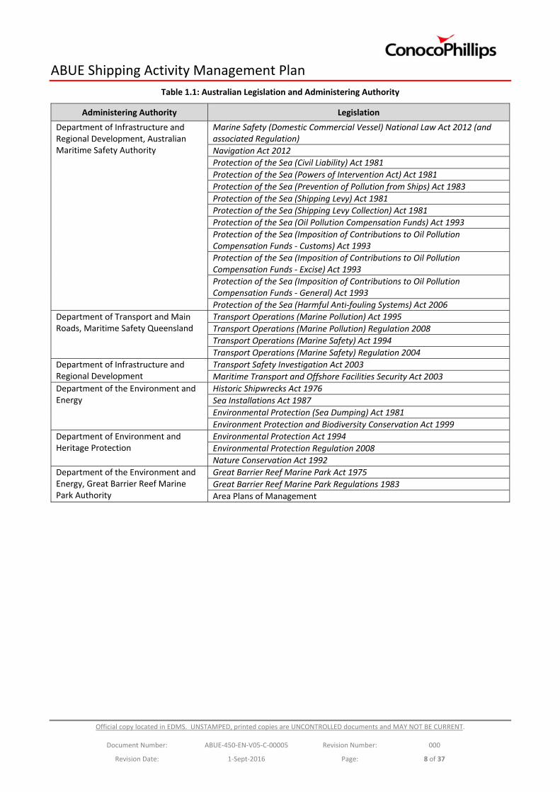
Relevant legislation is outlined in Table 1.1.
ABUE Shipping Activity Management Plan
Official copy located in EDMS. UNSTAMPED, printed copies are UNCONTROLLED documents and MAY NOT BE CURRENT.
Document Number: ABUE‐450‐EN‐V05‐C‐00005 Revision Number: 000
Revision Date: 1‐Sept‐2016 Page: 8 of 37
Table 1.1: Australian Legislation and Administering Authority
Administering Authority Legislation
Department of Infrastructure and Regional Development, Australian Maritime Safety Authority
Marine Safety (Domestic Commercial Vessel) National Law Act 2012 (and associated Regulation)
Navigation Act 2012
Protection of the Sea (Civil Liability) Act 1981
Protection of the Sea (Powers of Intervention Act) Act 1981
Protection of the Sea (Prevention of Pollution from Ships) Act 1983
Protection of the Sea (Shipping Levy) Act 1981
Protection of the Sea (Shipping Levy Collection) Act 1981
Protection of the Sea (Oil Pollution Compensation Funds) Act 1993
Protection of the Sea (Imposition of Contributions to Oil Pollution Compensation Funds ‐ Customs) Act 1993
Protection of the Sea (Imposition of Contributions to Oil Pollution Compensation Funds ‐ Excise) Act 1993
Protection of the Sea (Imposition of Contributions to Oil Pollution Compensation Funds ‐ General) Act 1993
Protection of the Sea (Harmful Anti‐fouling Systems) Act 2006
Department of Transport and Main Roads, Maritime Safety Queensland
Transport Operations (Marine Pollution) Act 1995
Transport Operations (Marine Pollution) Regulation 2008
Transport Operations (Marine Safety) Act 1994
Transport Operations (Marine Safety) Regulation 2004
Department of Infrastructure and Regional Development
Transport Safety Investigation Act 2003
Maritime Transport and Offshore Facilities Security Act 2003
Department of the Environment and Energy
Historic Shipwrecks Act 1976
Sea Installations Act 1987
Environmental Protection (Sea Dumping) Act 1981
Environment Protection and Biodiversity Conservation Act 1999
Department of Environment and Heritage Protection
Environmental Protection Act 1994
Environmental Protection Regulation 2008
Nature Conservation Act 1992
Department of the Environment and Energy, Great Barrier Reef Marine Park Authority
Great Barrier Reef Marine Park Act 1975
Great Barrier Reef Marine Park Regulations 1983
Area Plans of Management
ABUE Shipping Activity Management Plan
Official copy located in EDMS. UNSTAMPED, printed copies are UNCONTROLLED documents and MAY NOT BE CURRENT.
Document Number: ABUE‐450‐EN‐V05‐C‐00005 Revision Number: 000
Revision Date: 1‐Sept‐2016 Page: 9 of 37
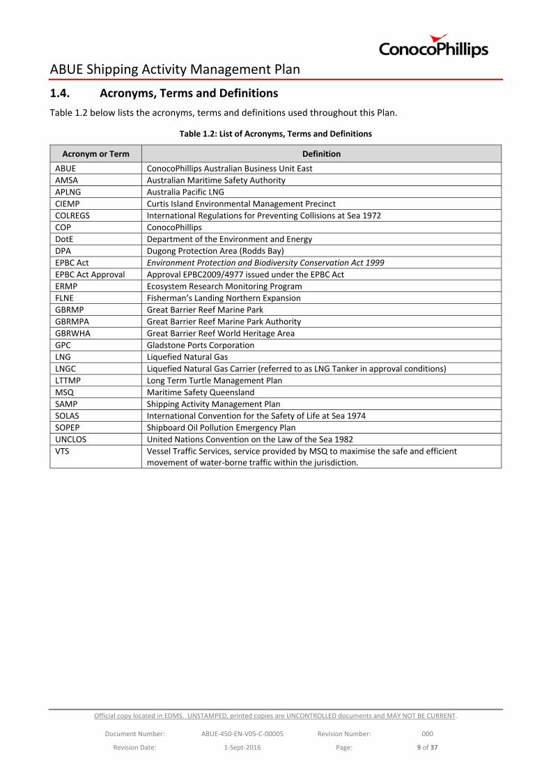
1.4. Acronyms, Terms and Definitions
Table 1.2 below lists the acronyms, terms and definitions used throughout this Plan.
Table 1.2: List of Acronyms, Terms and Definitions
Acronym or Term Definition
ABUE ConocoPhillips Australian Business Unit East
AMSA Australian Maritime Safety Authority
APLNG Australia Pacific LNG
CIEMP Curtis Island Environmental Management Precinct
COLREGS International Regulations for Preventing Collisions at Sea 1972
COP ConocoPhillips
DotE Department of the Environment and Energy
DPA Dugong Protection Area (Rodds Bay)
EPBC Act Environment Protection and Biodiversity Conservation Act 1999
EPBC Act Approval Approval EPBC2009/4977 issued under the EPBC Act
ERMP Ecosystem Research Monitoring Program
FLNE Fisherman’s Landing Northern Expansion
GBRMP Great Barrier Reef Marine Park
GBRMPA Great Barrier Reef Marine Park Authority
GBRWHA Great Barrier Reef World Heritage Area
GPC Gladstone Ports Corporation
LNG Liquefied Natural Gas
LNGC Liquefied Natural Gas Carrier (referred to as LNG Tanker in approval conditions)
LTTMP Long Term Turtle Management Plan
MSQ Maritime Safety Queensland
SAMP Shipping Activity Management Plan
SOLAS International Convention for the Safety of Life at Sea 1974
SOPEP Shipboard Oil Pollution Emergency Plan
UNCLOS United Nations Convention on the Law of the Sea 1982
VTS Vessel Traffic Services, service provided by MSQ to maximise the safe and efficient movement of water‐borne traffic within the jurisdiction.
ABUE Shipping Activity Management Plan
Official copy located in EDMS. UNSTAMPED, printed copies are UNCONTROLLED documents and MAY NOT BE CURRENT.
Document Number: ABUE‐450‐EN‐V05‐C‐00005 Revision Number: 000
Revision Date: 1‐Sept‐2016 Page: 10 of 37
2. Shipping Activities
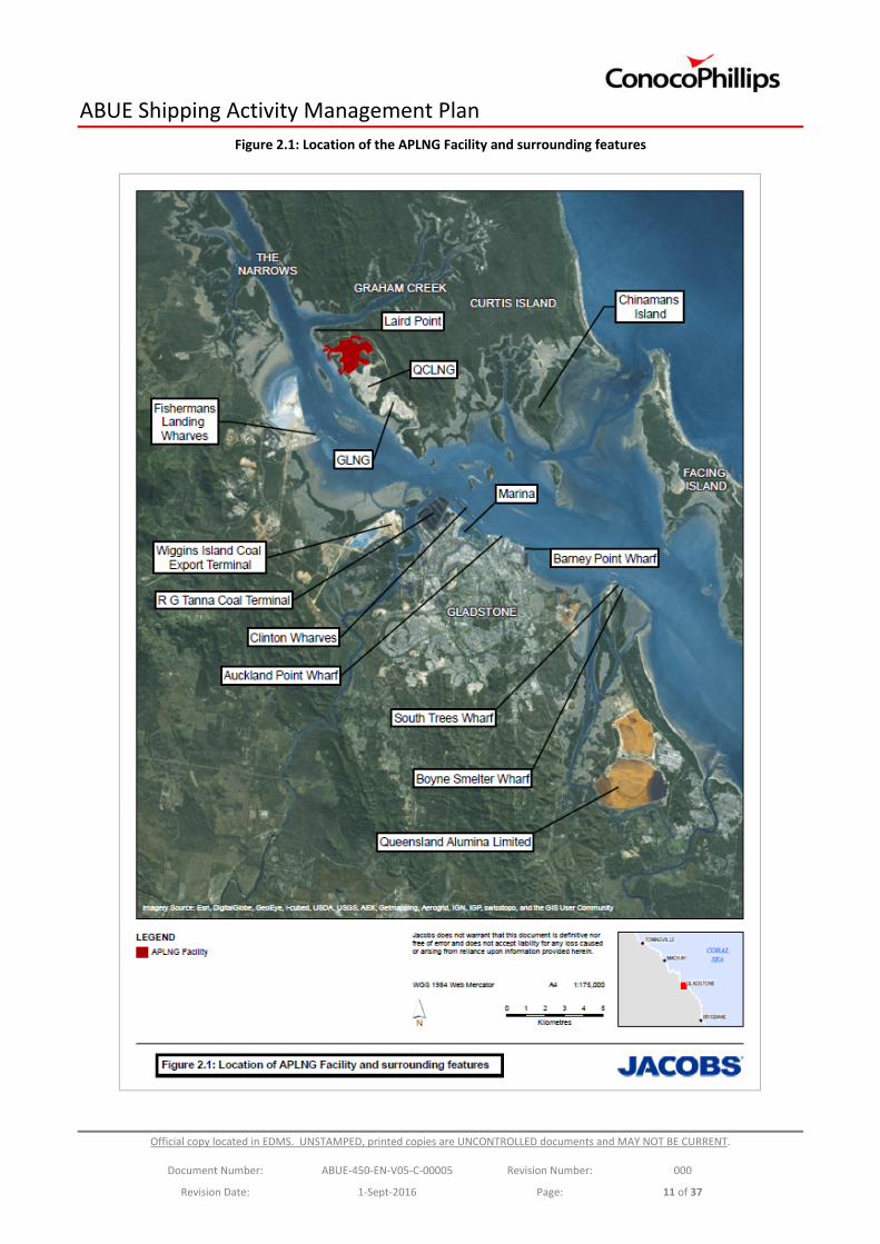
The APLNG Facility is located south of Laird Point on Curtis Island, approximately 525 km north of Brisbane, Queensland (Figure 2.1). The APLNG Facility is within the Port of Gladstone (Port Curtis), a deep water port which supports a variety of industrial activities.
Passenger ferries transport staff and contractors at the beginning and end of each shift between the Fisherman’s Landing Northern Expansion (FLNE) on the mainland and the APLNG Facility. At least six 3‐4km ferry journeys occur each day. However, additional movements of staff, contractors and supplies may take place as required outside of scheduled shift changes, for example in response to maintenance and shutdown activities.
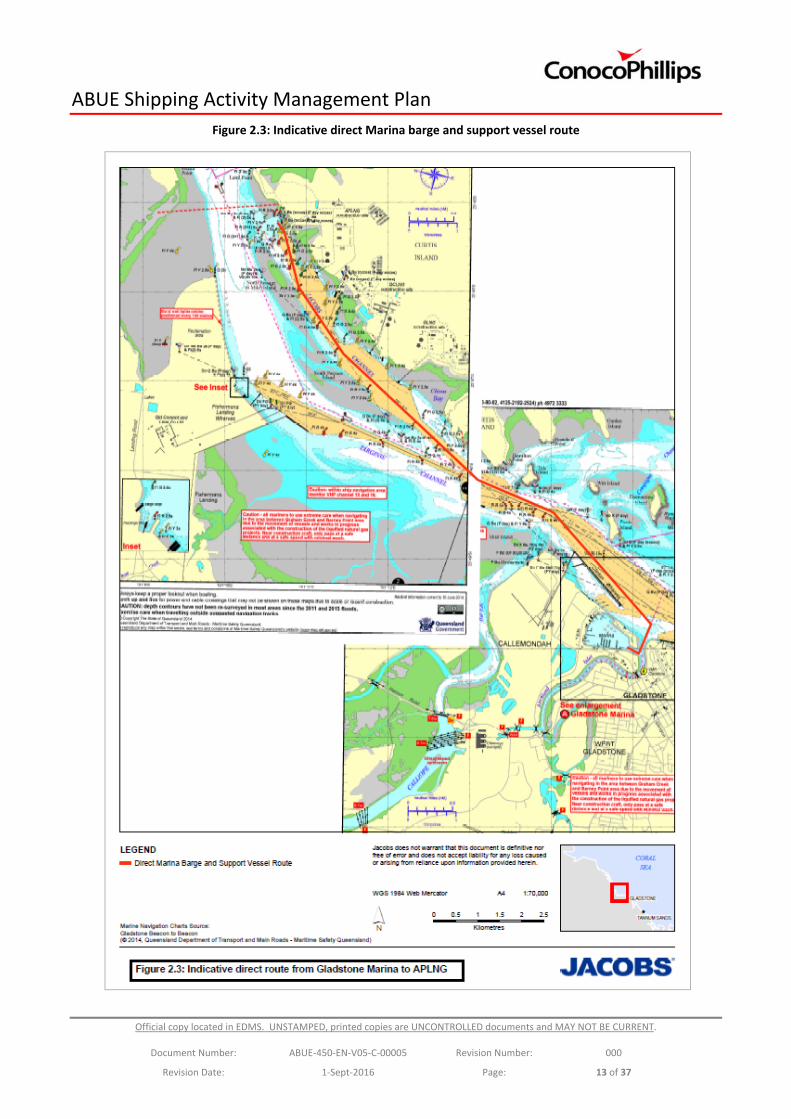
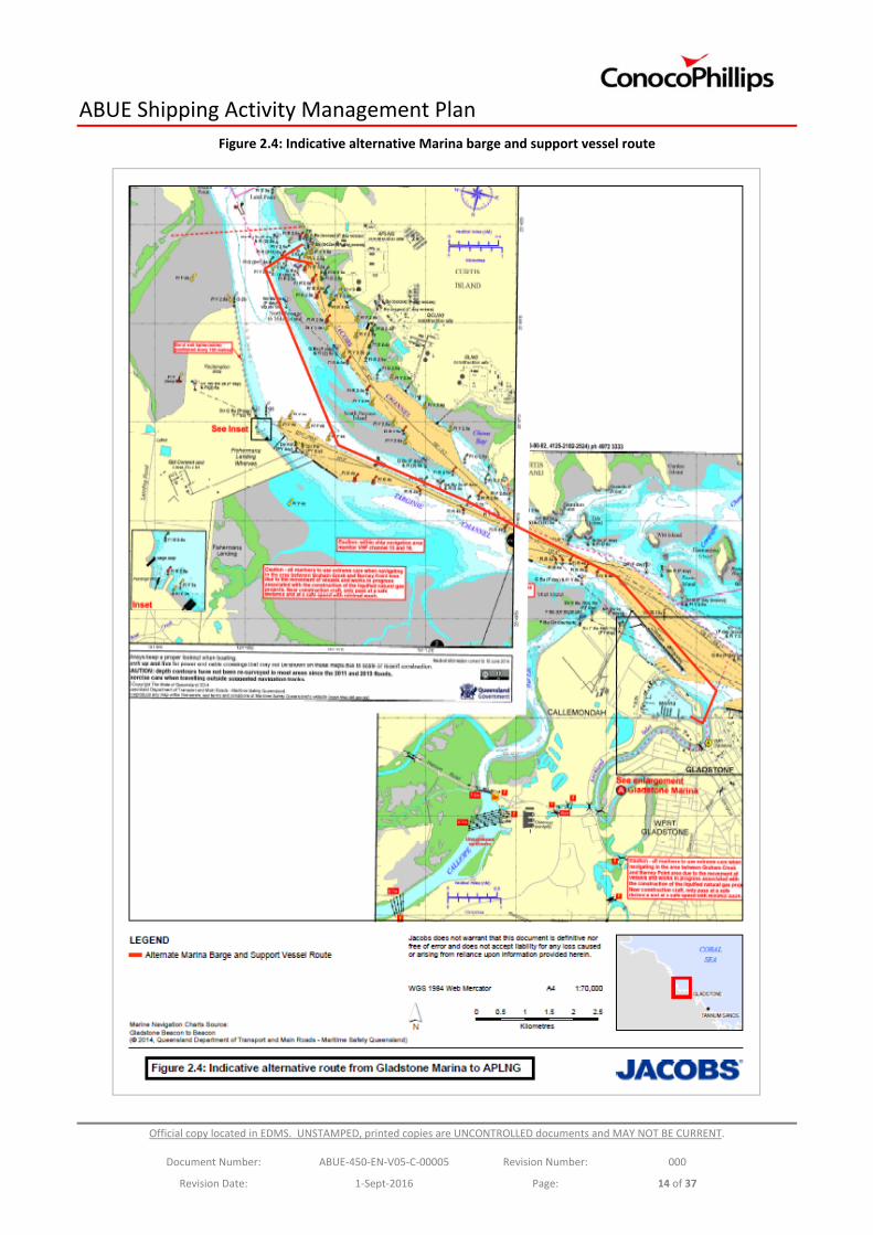
Barges and support vessels are used to transport personnel, equipment and materials between the mainland and the APLNG Facility. These vessels depart from a permanent facility at the Gladstone Marina and travel approximately 13‐14km to the APLNG Facility: either along a direct route utilising the marked navigation channels associated with Clinton Channel and Jacobs Channel; or alternatively the marked navigation channels associated with Clinton Channel and Targinie Channel, including the preferred ‘small craft track’ recommended by MSQ (Ship navigation area for small boats – Gladstone). They may also depart from the temporary facility at FLNE as required.
Barges, support vessels and ferries dock at the northern perimeter of the APLNG Facility, where a ramp for barge access and a ferry berthing facility are in place. Alternatively, docking may occur at the Material Offloading Facility (MOF) when maintenance or other activities are occurring at the primary dock.
Maps showing the indicative locations of the most common ferry, barge and support vessel routes utilised when servicing the APLNG Facility, are presented in Figures 2.2, 2.3 and 2.4. It should be noted that the route taken by each vessel will be determined by the vessel master and may be altered in response to operational or safety requirements, including where under the direction of the RHM, MSQ or Vessel Traffic Services (VTS).
ABUE Shipping Activity Management Plan
Official copy located in EDMS. UNSTAMPED, printed copies are UNCONTROLLED documents and MAY NOT BE CURRENT.
Document Number: ABUE‐450‐EN‐V05‐C‐00005 Revision Number: 000
Revision Date: 1‐Sept‐2016 Page: 11 of 37
Figure 2.1: Location of the APLNG Facility and surrounding features

ABUE Shipping Activity Management Plan
Official copy located in EDMS. UNSTAMPED, printed copies are UNCONTROLLED documents and MAY NOT BE CURRENT.
Document Number: ABUE‐450‐EN‐V05‐C‐00005 Revision Number: 000
Revision Date: 1‐Sept‐2016 Page: 12 of 37
Figure 2.2: Indicative FLNE ferry, barge and support vessel route
ABUE Shipping Activity Management Plan
Official copy located in EDMS. UNSTAMPED, printed copies are UNCONTROLLED documents and MAY NOT BE CURRENT.
Document Number: ABUE‐450‐EN‐V05‐C‐00005 Revision Number: 000
Revision Date: 1‐Sept‐2016 Page: 13 of 37
Figure 2.3: Indicative direct Marina barge and support vessel route
ABUE Shipping Activity Management Plan
Official copy located in EDMS. UNSTAMPED, printed copies are UNCONTROLLED documents and MAY NOT BE CURRENT.
Document Number: ABUE‐450‐EN‐V05‐C‐00005 Revision Number: 000
Revision Date: 1‐Sept‐2016 Page: 14 of 37
Figure 2.4: Indicative alternative Marina barge and support vessel route
ABUE Shipping Activity Management Plan
Official copy located in EDMS. UNSTAMPED, printed copies are UNCONTROLLED documents and MAY NOT BE CURRENT.
Document Number: ABUE‐450‐EN‐V05‐C‐00005 Revision Number: 000
Revision Date: 1‐Sept‐2016 Page: 15 of 37
3. Environmental Values
Port Curtis is located within the Great Barrier Reef World Heritage Area (GBRWHA) and provides habitat for a variety of threatened species including turtles, dugong and the water mouse. Coastal foreshores within sheltered waters to the north of the APLNG Facility, referred to as The Narrows, and waters offshore of Port Curtis are located within the Great Barrier Reef Marine Park (GBRMP).
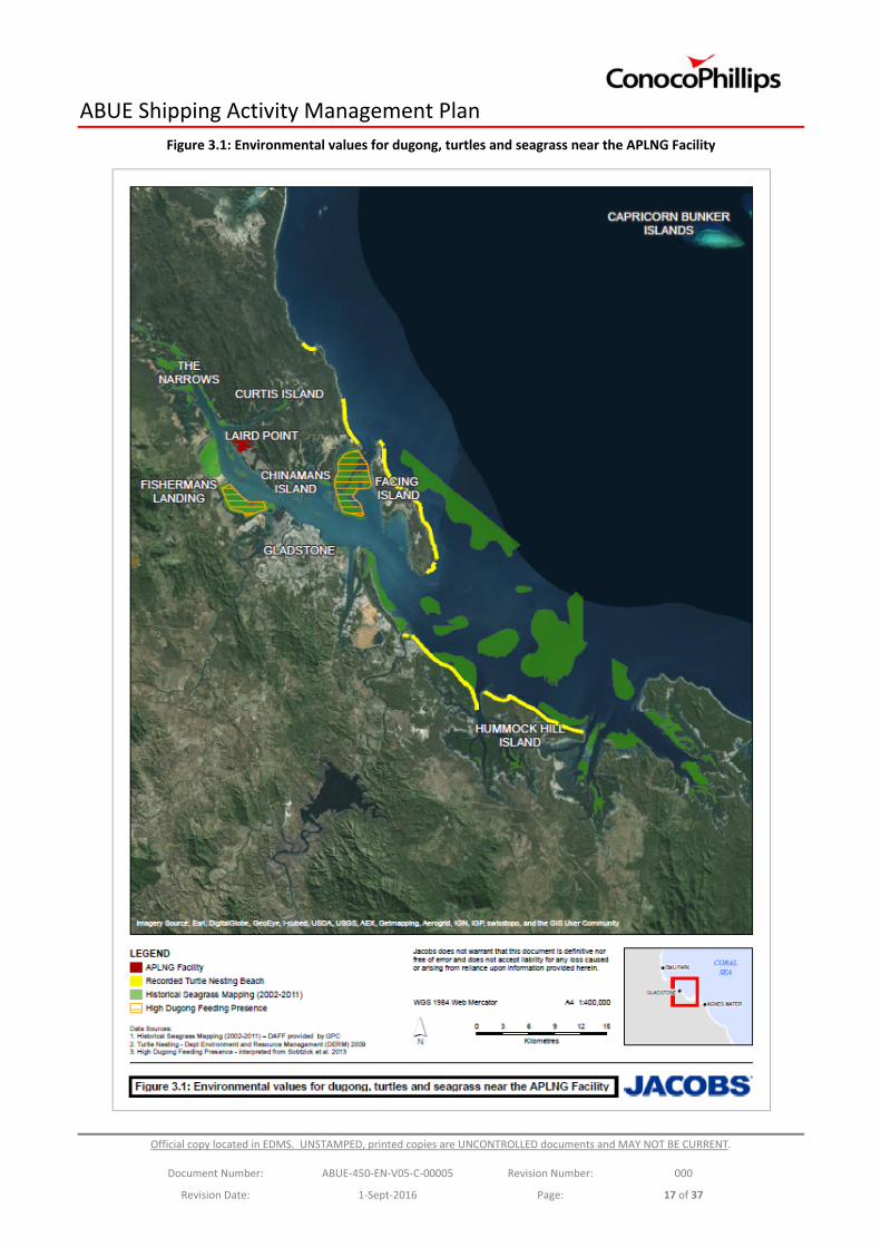
Condition 42 of the EPBC Act Approval specifies that the SAMP must include provisions for the protection of dugongs, marine turtles (loggerhead, flatback and green turtles), water mouse and a number of seagrass species; and identify the habitats, activities and environmental tolerances in relation to shipping activities for the above species (see Figure 3.1). This information is provided in the following sections.
3.1. Dugong
The dugong (Dugong dugon) is protected under the EPBC Act (Marine, Migratory) and is known to occur in the Gladstone region. The species is generally found in shallow protected waters where its primary foraging resource, seagrass, occurs.
The Gladstone region is considered to be of low to medium conservation value for dugongs at the scale of the GBRWHA (Grech and Marsh 2007). However, the local significance of Port Curtis as habitat for dugongs is demonstrated by the presence of the Rodds Bay Dugong Protection Area (DPA) which extends from the northern reaches of Port Curtis, south to Rodds Peninsula. While DPAs were established for the management of fisheries activities, they are indicative of the presence of important dugong habitat.
A recent review (Sobtzick et al. 2013) concluded that there is a relatively small population of dugongs in the Gladstone region, with important habitat overlapping with areas of human use. A compilation of various dugong monitoring initiatives indicates a high dugong presence south of Fisherman’s Landing and east of Chinaman’s Island, where shallow water seagrass beds are known to occur (Figure 3.1; Sobtzick et al. 2013). Marsh and Lawler (2007) estimated the dugong population of the Gladstone region at 183 (±66) individuals, with a more recent assessment predicting the population to be in the low hundreds (Sobtzick et al. 2013).
The majority of the dugong’s diet is comprised of seagrass (Sobtzick et al. 2013). Seagrass meadows in the Gladstone region are considered to be of regional importance as they represent the only major seagrass habitat between Hervey Bay and Shoalwater Bay, providing a crucial foraging resource for transiting dugongs (Chartrand et al. 2009; Rasheed et al. 2008; Sobtzick et al. 2013; Thomas et al. 2010).
3.2. Marine Turtles
3.2.1. Loggerhead Turtle
Loggerhead turtles (Caretta caretta) are protected under the EPBC Act, and listed as Endangered, Marine, and Migratory. Loggerhead turtles occur in the Gladstone region, with transient, foraging and nesting turtles all recorded in various locations (EPA 2003; Limpus et al. 2013a). The Capricorn Bunker group of islands and reefs (located 60 km east of the APLNG Facility) is an important feeding habitat and breeding area for loggerhead turtles, while nesting loggerhead turtles have occasionally been recorded on the eastern side of Curtis and Facing islands (GHD 2009; Limpus et al. 2013a). The peak nesting period for loggerhead turtles is during December, with hatching occurring up until the end of April (EHP 2014).
The diet of loggerhead turtles mainly consists of invertebrates (e.g. gastropods and bivalve molluscs) and fish to a lesser extent (Limpus 2008). The Gladstone region has a perennial feeding ground and may provide feeding habitats for inter‐nesting females, and resident and transient loggerheads of both sexes.
ABUE Shipping Activity Management Plan
Official copy located in EDMS. UNSTAMPED, printed copies are UNCONTROLLED documents and MAY NOT BE CURRENT.
Document Number: ABUE‐450‐EN‐V05‐C‐00005 Revision Number: 000
Revision Date: 1‐Sept‐2016 Page: 16 of 37
3.2.2. Flatback Turtle
Flatback turtles (Natator depressus) are protected under the EPBC Act, and listed as Vulnerable, Marine, and Migratory. Flatback turtles occur in the Gladstone region with transient, foraging and nesting turtles all recorded (Limpus et al. 2013b; EPA 2003). The species is endemic to northern Australia and southern New Guinea, with breeding mostly restricted to Australia (Limpus et al. 2013b).
Peak Island (located approximately 52 km north of the APLNG Facility) is a major nesting rookery with approximately 200 females nesting each year (Limpus et al. 2013b). South End Beach on Curtis Island is an intermediate sized nesting beach, with an average of 56 females nesting each year (Limpus et al. 2013b). Nesting also occurs in low numbers on the eastern side of Facing Island, at Tannum Sands and at Hummock Hill Island (Limpus 2007).
The peak nesting period for flatback turtles is mid‐November to mid‐December, with the peak hatching period in February (Limpus 2007; QGC 2014). The flatback turtle primarily forages in subtidal soft bottom habitats, with a diet primarily consisting of soft‐bodied animals such as soft corals, sea cucumbers and jellyfish (EHP 2014).
3.2.3. Green Turtle
Green turtles (Chelonia mydas) are protected under the EPBC Act, and listed as Vulnerable, Marine, and Migratory. Green turtles occur in the Gladstone region, with transient, foraging and occasional nesting turtles recorded (Limpus et al. 2006,). A large number of juvenile and sub‐adult green turtles have been recorded in the Gladstone region feeding on seagrass, algae and potentially invertebrates (GPC 2011; Limpus et al. 2013c).
The Capricorn Bunker group of islands are and important breeding area for green turtles (Limpus et al. 2013c). The Gladstone area provides important inter‐nesting habitat for breeding females (Limpus et al. 2013c). Occasional nesting has been recorded on Curtis and Facing Islands, with peak nesting in mid‐December to mid‐January and peak hatching in February and March (Limpus et al. 2013c.)
3.3. Cetaceans
All cetaceans are protected under the EPBC Act. Five species of cetaceans (one whale and four dolphins) are known to occur in the Gladstone area. The humpback whale (Megaptera novaeangliae, listed as Vulnerable, and Migratory) migrates to the waters of the GBRMP to breed and calve in the winter months with the Capricorn Bunker Island (100 km east of Gladstone) an important migratory route (Smith et al. 2012). Humpback whales have been occasionally recorded in Gladstone Harbour.
The Australian snubfin dolphin (Orcaella heinsohni, Migratory), the Indo‐Pacific humpback dolphin (Sousa chinensis or Sousa sahulensis, Migratory), the Indo‐Pacific (or Indian Ocean) bottlenose dolphin (Tursiops aduncus) and the offshore bottlenose dolphin (Tursiops truncatus) have been recorded in the Gladstone region on numerous occasions. Of these species, the Indo‐Pacific humpback dolphin is the most frequently sighted in Port Curtis, with foraging, transiting and socialising behaviours recorded (Cagnazzi 2013).
ABUE Shipping Activity Management Plan
Official copy located in EDMS. UNSTAMPED, printed copies are UNCONTROLLED documents and MAY NOT BE CURRENT.
Document Number: ABUE‐450‐EN‐V05‐C‐00005 Revision Number: 000
Revision Date: 1‐Sept‐2016 Page: 17 of 37
Figure 3.1: Environmental values for dugong, turtles and seagrass near the APLNG Facility
ABUE Shipping Activity Management Plan
Official copy located in EDMS. UNSTAMPED, printed copies are UNCONTROLLED documents and MAY NOT BE CURRENT.
Document Number: ABUE‐450‐EN‐V05‐C‐00005 Revision Number: 000
Revision Date: 1‐Sept‐2016 Page: 18 of 37
3.4. Water Mouse
The water mouse (Xeromys myoides) is protected under the EPBC Act, and is listed as Vulnerable. The Gladstone region, including Curtis Island, supports water mouse habitat which generally includes mangrove wetlands and saltmarshes (QGC 2013). The water mouse has a diet primarily consisting of crustaceans and bivalves (QGC 2013).
Habitat modelling estimates approximately 9,483.79 ha of habitat suitable for the water mouse is present on Curtis Island (Ecofund Queensland 2013, QGC, 2014). The water mouse has been recorded near the APLNG Facility, indicating a possible presence in the area (QGC 2013). However, limited habitat is present in the Curtis Island Industry Precinct and surveys have recorded few sightings or potential nesting sites. Such information suggests that while water mouse habitat is present in close proximity to the APLNG Facility and adjacent shipping channels, few individuals utilise the area.
3.5. Seagrass
Seagrass communities provide critical habitat and food for a variety of marine organisms, including species listed under the EPBC Act such as turtles and dugong. Monitoring has recorded extensive intertidal and deepwater seagrass meadows in the Gladstone region (Figure 3.1). Numerous seagrass surveys have been conducted in the area since 1987, involving mapping and long‐term monitoring, which have identified considerable variability in the abundance and distribution of seagrass, particularly within inshore areas. This variability has often been caused by changes in local and regional climatic conditions, such as flood events (McKenzie et al. 2011, 2012; Rasheed et al. 2008; Thomas et al. 2010).
Seven species of seagrass have been identified in the Port Curtis and Rodds Bay area including Zostera capricorni, Halodule uninervis¸ Cymodocea rotundata, Halophila ovalis, Halophila decipiens, Halophila minor and Halophila spinulosa (York and Smith 2013). Several of these species provide an important food source and/or habitat for dugong, green turtles and commercially‐important fisheries species.
Seagrass meadows in the Gladstone region are considered to be regionally significant as they provide the only major area of seagrass habitat between Hervey Bay and Shoalwater Bay (Chartrand et al. 2009; Rasheed et al. 2003, 2008; Sobtzick et al 2013; Taylor et al. 2006, 2007; Thomas et al. 2010;). The seagrass meadows provide a foraging resource and habitat for local fauna, and those transiting along the coast. In this context, the seagrass meadows of Port Curtis are likely to provide an important connecting habitat for transient animals including dugongs.
ABUE Shipping Activity Management Plan
Official copy located in EDMS. UNSTAMPED, printed copies are UNCONTROLLED documents and MAY NOT BE CURRENT.
Document Number: ABUE‐450‐EN‐V05‐C‐00005 Revision Number: 000
Revision Date: 1‐Sept‐2016 Page: 19 of 37
4. Potential Impacts on Environmental Values
Shipping activities have the potential to impact EPBC Act‐listed marine species and their habitats through a variety of mechanisms. The risk of an impact varies according to many factors including vessel design and size, vessel speed, location of shipping routes in relation to key habitats, the frequency of vessel operations and variations in the quality and quantity of resources such as seagrasses in response to natural events such as flooding.
This section provides an overview of the potential of operational shipping activities to affect species listed in Condition 42 of the EPBC Act Approval. Mitigation measures to address these potential impacts are described in section 6.
4.1. Vessel Strike
Turtles and dugong breathe air at the water’s surface and often forage on seagrass in shallow water less than 10m in depth. Turtles and dugong can be slow to respond to the sound or sight of an approaching vessel and may be injured or killed from the blunt trauma of a fast moving vessel or cuts inflicted by a vessel’s propeller.
Records published by the Department of Environment and Heritage Protection (Biddle and Limpus 2011) indicate that vessel strikes occur regularly on turtles in Queensland in locations where vessel traffic and key feeding habitat coincide (e.g., Moreton Bay). There are fewer reported vessel strikes on dugong than turtles in Queensland, although vessel strike ‘hot spots’ may occur in areas where a high frequency of vessel traffic coincides with dugong habitat (Yeates and Limpus 2003).
It is generally accepted that the risk of vessel strike increases with vessel speed (Hazel et al. 2007). The slower a vessel is moving, the more time is available for the turtle or dugong to recognise the danger and take action to avoid a collision. In addition, the force of a strike is reduced at slower speeds. If the turtle or dugong is visible to the vessel master, then action may also be taken by the vessel master to avoid a collision, by reducing speed or changing direction. However, such action is dependent upon the size of the vessel and safety considerations. Generally, small vessels are more manoeuvrable than large vessels, and have greater capacity to be navigated to avoid collisions.
The risk of injury to turtles, dugong and cetaceans from vessel strike can be reduced on some ships through vessel design. This may involve reducing the draft of the vessel by applying modern hull designs, designing rounded edges into the hull layout and using jet propulsion rather than propellers.
Water depth also plays a role in determining the risk of vessel strike. Shallow seagrass habitats used for foraging are likely to be of higher risk than deeper areas where there is significant clearance between the vessel hull and the seabed (Hazel 2009). Deeper areas also allow the animal to dive to avoid a collision, provided that the vessel speed is not too high to prevent such a response. In this context, the risk of vessel strike is likely to be higher within shipping channels surrounded by shallow seagrass habitats than in deeper habitats offshore.
4.2. Shoreline Erosion from Vessel Wash
The coastal foreshores of Port Curtis are dynamic systems which change in response to a range of natural variables, including tides, currents, flood events, wind and cyclones. Such processes can cause natural erosion or accretion of foreshores, with marine habitats such as mangroves and seagrass meadows playing an important role in foreshore stabilisation.
ABUE Shipping Activity Management Plan
Official copy located in EDMS. UNSTAMPED, printed copies are UNCONTROLLED documents and MAY NOT BE CURRENT.
Document Number: ABUE‐450‐EN‐V05‐C‐00005 Revision Number: 000
Revision Date: 1‐Sept‐2016 Page: 20 of 37
Shipping activities have the potential to cause erosion beyond that which may occur naturally. The regular wash created by the hull, propeller or thrusters of vessels, particularly in sheltered inshore areas may cause an increase in foreshore erosion. Such effects may change the diversity and structure of wetland habitats which are utilised by the water mouse for feeding and nesting. An increase in turbidity and sediment deposition caused by erosion of the foreshore may indirectly impact on seagrass habitats by reducing the quality and quantity of light reaching the seabed and available for photosynthesis.
4.3. Turbidity Plumes
When the hull of a vessel and the currents produced by its propulsion are in proximity to the sea bed, there is potential for turbidity plumes to be produced through the suspension of sediments. Once sediments on the sea floor become resuspended in the water column, they can drift in currents into adjacent areas, reducing water quality and light intensity on the sea bed. When such sediments settle back to the sea floor, they may smother filter‐feeding benthic communities. Sediment plumes may also disturb mobile marine fauna such as turtles and dugongs, or reduce the quantity or quality of seagrass areas used for foraging. The use of thrusters to assist navigation within inshore areas may increase the likelihood of plumes being produced, particularly at low tide.
4.4. Noise and General Disturbance
Port Curtis is a highly industrialised port, with approximately 1500 ship movements each year (GHD 2013). The shipping activities associated with the APLNG Facility operations will result in incremental increases in underwater noise and general disturbance from the pre‐development scenarios within Port Curtis and the Great Barrier Reef lagoon, the disturbance will decrease when compared to the construction phase. Such affects may act cumulatively with existing shipping disturbance by displacing threatened species to alternative locations and interfering with natural behaviours such as foraging or communication by sound.
4.5. Lighting Disturbance
Vessels must be illuminated at night to provide for safe navigation. Lighting on vessels can disturb the behaviour of nesting turtles and emerging turtle hatchlings, which use light or the absence of light as visual cues to navigate to a nesting beach or from a beach towards the ocean.
Nesting turtles generally select a nesting site at night and light disturbance can significantly reduce the number of nesting attempts of female turtles (Witherington 1992). Turtle hatchlings tend to emerge at night and crawl directly towards the horizon, which is often lit by stars.
The effects of lighting on vessels can be expected to be most significant when vessels are anchored for prolonged periods in the direct line of sight of nesting beaches. Groups of anchored vessels with lights may cause disorientation to turtle hatchlings, resulting in increased predation and risk of desiccation from failure to reach the water.
4.6. Pollution through Spills and Discarded Waste
Ships can pollute the marine environment through spills of contaminants such as fuel, oil, chemicals, waste water or solid waste. The quantity and nature of potential contaminants on‐board varies significantly among vessel types, based on their size, application, mode of operation and design. Pollution events may occur in the event of damage to a ship’s hull, caused by a vessel collision, grounding or cyclone. Pollution from vessels can have a range of environmental impacts, including contamination of wetland or seagrass habitats with hydrocarbons or heavy metals, potentially resulting in toxic effects on marine fauna.
ABUE Shipping Activity Management Plan
Official copy located in EDMS. UNSTAMPED, printed copies are UNCONTROLLED documents and MAY NOT BE CURRENT.
Document Number: ABUE‐450‐EN‐V05‐C‐00005 Revision Number: 000
Revision Date: 1‐Sept‐2016 Page: 21 of 37
5. Risk Assessment
A comprehensive risk assessment of the potential impacts of shipping‐related activities undertaken by, or under the control of APLNG on the species specified in Condition 42 (a) of the EPBC Act Approval has been completed. The risk assessment approach is based on the ConocoPhillips Risk Matrix, which considers the following key steps:
Identification of hazards
Assessment of the likelihood and consequence of the hazard
Assignment of a risk rating (inherent risk)
Consideration of mitigation measures
Reassessment of the risk rating, by re‐evaluating the likelihood criteria, given the influence of mitigation measures (residual risk)
A summary of the criteria used to determine the likelihood and consequence of each potential impact is set out in Table 5.1. For each hazard scenario, the realistic potential consequence and likelihood of the event occurring was evaluated, without considering active mitigation or safeguards in place. The assessment was then repeated, following consideration of all mitigation measures and safeguards. These mitigation measures are summarised in section 6 below.
The likelihood of an impact occurring on listed species or their habitat was assessed at a population level. The consequence rating is based upon the most probable consequence for populations of EPBC Act‐listed species and their habitats given the nature of the activity. When combined, the consequence and likelihood ratings provide a risk rating, which can be used to describe the risk of impacts on biodiversity (threatened species and their habitat).
The risk assessment was reviewed in July 2016 following the proposed addition of barge and support vessel movements from a permanent facility at the Gladstone Marina. The results of this review are incorporated into Table 5.2 below.

ABUE Shipping Activity Management Plan
Official copy located in EDMS. UNSTAMPED, printed copies are UNCONTROLLED documents and MAY NOT BE CURRENT.
Document Number: ABUE‐450‐EN‐V05‐C‐00005 Revision Number: 000
Revision Date: 1‐Sept‐2016 Page: 22 of 37
Table 5.1: Summary of ConocoPhillips Risk Assessment Matrix
Likelihood Rating (probability of occurrence)
Consequence Rating
Category 1 – Minor loss or migration of species (<10%), habitat or ecosystem which are short term and completely reversible.
Category 2 – Brief loss or migration of species (<15%), habitat or ecosystem which are short term and completely reversible. Minor reclamation efforts required for total reversal.
Category 3 – Temporary loss or migration of species (<25%), habitat or ecosystem which are short term and completely reversible. Moderate reclamation efforts required for total reversal.
Category 4 – Serious loss or migration of species (>50%), habitat or ecosystem. Partial reversal only possible through intensive reclamation efforts (>50 years).
Category 5 – Catastrophic permanent loss or extinction of species (100%), habitat or ecosystem. Irrevocable loss, no reclamation possible.
5 ‐ Frequent (multiple times per year)
Medium Medium Significant High High
4 ‐ Probable (several times in recent memory of an experienced employee)
Low Medium Significant Significant High
3 ‐ Rare (Once or twice in the extreme memory of an experienced employee)
Low Medium Medium Significant Significant
2‐ Remote (May or may not occur in the extreme memory of an experienced employee)
Low Low Medium Medium Medium
1 ‐ Improbable Low Low Low Low Medium
ABUE Shipping Activity Management Plan
Official copy located in EDMS. UNSTAMPED, printed copies are UNCONTROLLED documents and MAY NOT BE CURRENT.
Document Number: ABUE‐450‐EN‐V05‐C‐00005 Revision Number: 000
Revision Date: 1‐Sept‐2016 Page: 23 of 37
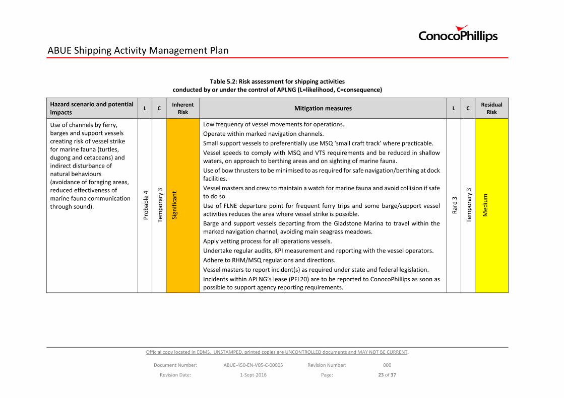
Table 5.2: Risk assessment for shipping activities conducted by or under the control of APLNG (L=likelihood, C=consequence)
Hazard scenario and potential impacts
L C Inherent Risk
Mitigation measures L C Residual Risk
Use of channels by ferry, barges and support vessels creating risk of vessel strike for marine fauna (turtles, dugong and cetaceans) and indirect disturbance of natural behaviours (avoidance of foraging areas, reduced effectiveness of marine fauna communication through sound).
Probable 4
Temporary 3
Significant
Low frequency of vessel movements for operations.
Operate within marked navigation channels.
Small support vessels to preferentially use MSQ ‘small craft track’ where practicable.
Vessel speeds to comply with MSQ and VTS requirements and be reduced in shallow waters, on approach to berthing areas and on sighting of marine fauna.
Use of bow thrusters to be minimised to as required for safe navigation/berthing at dock facilities.
Vessel masters and crew to maintain a watch for marine fauna and avoid collision if safe to do so.
Use of FLNE departure point for frequent ferry trips and some barge/support vessel activities reduces the area where vessel strike is possible.
Barge and support vessels departing from the Gladstone Marina to travel within the marked navigation channel, avoiding main seagrass meadows.
Apply vetting process for all operations vessels.
Undertake regular audits, KPI measurement and reporting with the vessel operators.
Adhere to RHM/MSQ regulations and directions.
Vessel masters to report incident(s) as required under state and federal legislation.
Incidents within APLNG’s lease (PFL20) are to be reported to ConocoPhillips as soon as possible to support agency reporting requirements.
Rare 3
Temporary 3
Med
ium
ABUE Shipping Activity Management Plan
Official copy located in EDMS. UNSTAMPED, printed copies are UNCONTROLLED documents and MAY NOT BE CURRENT.
Document Number: ABUE‐450‐EN‐V05‐C‐00005 Revision Number: 000
Revision Date: 1‐Sept‐2016 Page: 24 of 37
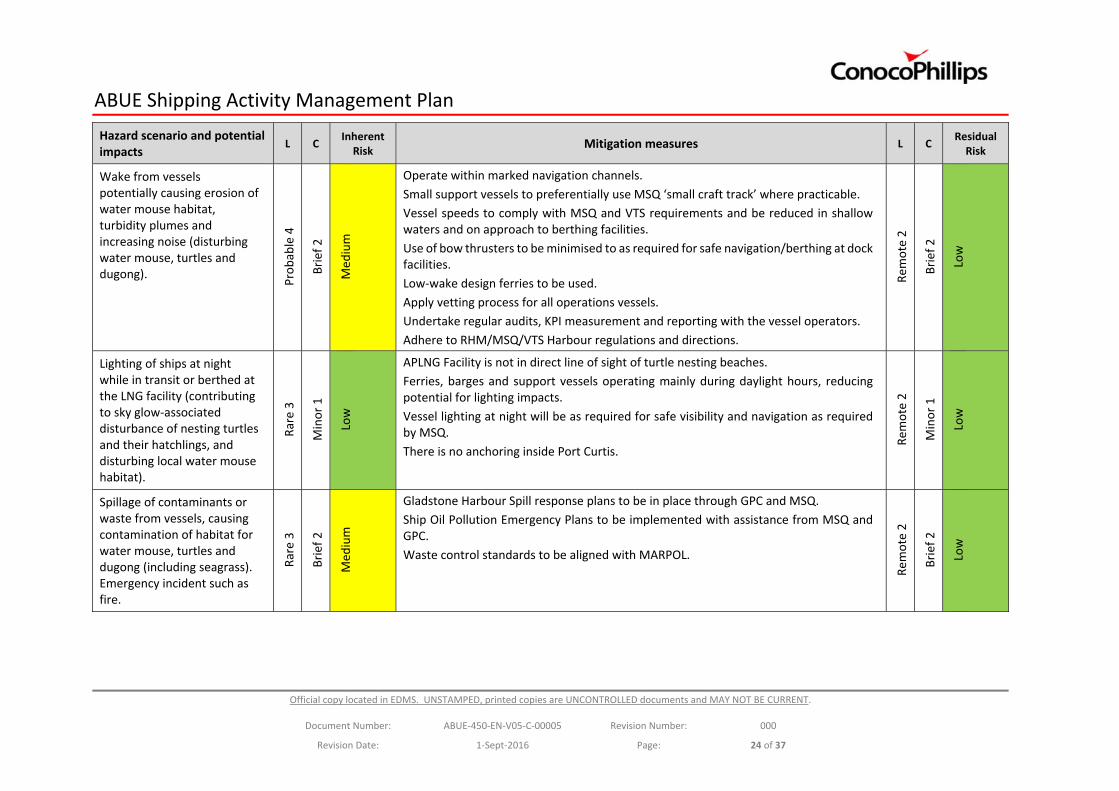
Hazard scenario and potential impacts
L C Inherent Risk
Mitigation measures L C Residual Risk
Wake from vessels potentially causing erosion of water mouse habitat, turbidity plumes and increasing noise (disturbing water mouse, turtles and dugong).
Probable 4
Brief 2
Med
ium
Operate within marked navigation channels.
Small support vessels to preferentially use MSQ ‘small craft track’ where practicable.
Vessel speeds to comply with MSQ and VTS requirements and be reduced in shallow waters and on approach to berthing facilities.
Use of bow thrusters to be minimised to as required for safe navigation/berthing at dock facilities.
Low‐wake design ferries to be used.
Apply vetting process for all operations vessels.
Undertake regular audits, KPI measurement and reporting with the vessel operators.
Adhere to RHM/MSQ/VTS Harbour regulations and directions.
Rem
ote 2
Brief 2
Low
Lighting of ships at night while in transit or berthed at the LNG facility (contributing to sky glow‐associated disturbance of nesting turtles and their hatchlings, and disturbing local water mouse habitat).
Rare 3
Minor 1
Low
APLNG Facility is not in direct line of sight of turtle nesting beaches.
Ferries, barges and support vessels operating mainly during daylight hours, reducing potential for lighting impacts.
Vessel lighting at night will be as required for safe visibility and navigation as required by MSQ.
There is no anchoring inside Port Curtis.
Rem
ote 2
Minor 1
Low
Spillage of contaminants or waste from vessels, causing contamination of habitat for water mouse, turtles and dugong (including seagrass). Emergency incident such as fire.
Rare 3
Brief 2
Med
ium
Gladstone Harbour Spill response plans to be in place through GPC and MSQ.
Ship Oil Pollution Emergency Plans to be implemented with assistance from MSQ and GPC.
Waste control standards to be aligned with MARPOL.
Rem
ote 2
Brief 2
Low
ABUE Shipping Activity Management Plan
Official copy located in EDMS. UNSTAMPED, printed copies are UNCONTROLLED documents and MAY NOT BE CURRENT.
Document Number: ABUE‐450‐EN‐V05‐C‐00005 Revision Number: 000
Revision Date: 1‐Sept‐2016 Page: 25 of 37
6. Mitigation Measures
The following mitigation measures will be implemented to minimise the impact of shipping activities undertaken by, or under the control of APLNG on EPBC Act‐listed species and their habitats in accordance with EPBC Act Approval condition 42 d). These controls will be implemented to the extent that is consistent with applicable law and any requirement or direction given by the RHM, MSQ, VTS or pilot.
6.1. Vessel Strike
To minimise the risk of vessel interactions with marine fauna the following control measures will be in place:
The frequency of vessel trips will be minimised where possible, typically involving six return ferry trips, one or two barge trips and support vessel trips as required per day; with additional barge trips and vessel support trips to be determined on the need of the APLNG Facility.
Ferry, barge and support vessels will use marked navigation channels to maximise clearance.
Support vessels will preferentially use the MSQ recommended ‘small craft track’ where practicable to maintain safe distances from shipping vessels. The support vessels are generally small in size with shallow draft and are highly manoeuvrable.
Vessel speeds will comply with MSQ and VTS requirements. Ferries and barges will generally operate at speeds of less than 15 knots and small support vessels at less than 25 knots; with speeds reduced to less than 6 knots on sighting of marine fauna; within 30m of a jetty, wharf, vessel ramp, pontoon or ship; and in areas where wash is reasonably capable of causing damage to the shoreline as per the requirements of the Transport Operations (Marine Safety) Regulation 2004 (Qld). Speeds will also be reduced in shallow water (<5m) where interactions with turtle and dugong are more likely.
The use of bow thrusters will be minimised to as required for safe navigation/berthing at dock facilities.
Ferries, barges and support vessels will operate mostly during daylight hours, when the visibility of marine fauna to the vessel master and crew will be highest;
Vessel masters and crew will maintain a watch for marine fauna and avoid collision if safe to do so.
Mainland departure point for ferries, as well as some barges and support vessels, is at Fisherman’s Landing Northern Expansion only 3‐4km from the APLNG Facility. This significantly reduces the area where vessel strike is possible during ferry trips.
Most barge and support vessels will depart from a permanent facility at the Gladstone Marina and travel approximately 13‐14km within marked navigation channels to avoid the main seagrass meadows, to the APLNG facility.
In the event of a vessel strike a review of the circumstances will be conducted in accordance with an Incident Reporting and Investigation Process to determine any other mitigation measures that could be implemented to prevent future occurrences.
A vetting process applies for all operations vessels and regular audits, KPI measurement and reporting will be undertaken with vessel operators.
All vessels are guided by adherence to RHM, MSQ and VTS requirements and directions.
Vessel masters are to report incident(s) as required under state and federal legislation for example Transport Operations (Marine Safety) Act 1994.
Incidents within APLNG’s lease (PFL20) are to be reported to ConocoPhillips as soon as possible to support agency reporting requirements.
ABUE Shipping Activity Management Plan
Official copy located in EDMS. UNSTAMPED, printed copies are UNCONTROLLED documents and MAY NOT BE CURRENT.
Document Number: ABUE‐450‐EN‐V05‐C‐00005 Revision Number: 000
Revision Date: 1‐Sept‐2016 Page: 26 of 37
6.2. Shoreline Erosion from Vessel Wash
Ferries, barges and support vessels will operate within marked navigation channels to maximise distances from shorelines. Small support vessels with shallow draft will preferentially use the MSQ recommended ‘small craft track’ where practicable, to avoid potential interaction with shipping activities.
Vessel speeds will comply with MSQ and VTS requirements. Ferries and barges will generally operate at speeds of less than 15 knots and small support vessels at less than 25 knots; with speeds reduced to less than 6 knots within 30m of a jetty, wharf, vessel ramp, pontoon or ship; and in areas where wash is reasonably capable of causing damage to the shoreline as per the requirements of the Transport Operations (Marine Safety) Regulation 2004 (Qld). Speeds will also be reduced in shallow water (<5m) where interactions with turtle and dugong are more likely.
The use of bow thrusters will be minimised to as required for safe navigation/berthing at dock facilities and low‐wake design ferries will be used.
The ABUE vetting process applies for all operations vessels and regular audits, KPI measurement and reporting will be undertaken with the Vessel operators.
6.3. Turbidity Plumes
A number of the controls in place to mitigate vessel strike and vessel wash will also reduce the risk of generating turbidity plumes including:
Ferries, barges and support vessels will operate within marked navigation channels which will maximise clearance between vessel hull and sea bed, minimising the risk of sediment resuspension and the generation of turbidity plumes.
Small support vessels with shallow draft will preferentially use the MSQ recommended ‘small craft track’ within the marked navigation channels, where practicable, to avoid shallow waters and potential interaction with shipping activities.
Vessels speeds will comply with MSQ and VTS requirements and will be reduced to less than 6 knots in shallow waters (<5m depth) where resuspension of sediments is more likely.
Bow‐thrusters will only be used where necessary for safe navigation and manoeuvring.
6.4. Noise and General Disturbance
As Port Curtis is already highly industrialised, the shipping activities associated with the APLNG Facility operations will result in incremental increases in underwater noise and general disturbance from the pre‐development scenarios. For any given vessel, noise emissions are a function of speed. In this context, restrictions on speed will assist in reducing under water noise.
All vessels will be approved through the ABUE vetting process prior to use.
6.5. Lighting Disturbance
Vessels must be illuminated at night to provide for safe navigation and comply with relevant regulations and MSQ requirements. Ferry, barge and support vessels will operate primarily during daylight hours and will be illuminated as required by MSQ if travelling between sunset and sunrise, and in periods of restricted visibility.
Within Port Curtis, the APLNG Facility is not in the direct line of sight of any known turtle nesting beaches. Vessels, jetties and marine offloading facilities at the APLNG Facility will avoid using excessive lighting to reduce their contribution to the overall sky glow of the Gladstone region.
ABUE Shipping Activity Management Plan
Official copy located in EDMS. UNSTAMPED, printed copies are UNCONTROLLED documents and MAY NOT BE CURRENT.
Document Number: ABUE‐450‐EN‐V05‐C‐00005 Revision Number: 000
Revision Date: 1‐Sept‐2016 Page: 27 of 37
6.6. Pollution through Spills and Discarded Waste
Marine discharges will be managed in accordance with the Ship Oil Pollution Emergency Plan (SOPEP), reporting through the APLNG spill reporting process, Gladstone Port Procedure, Australian and Queensland legislation and international conventions. This will reduce the risk of any discharges within the GBRWHA.
There will be no vessel cleaning or antifouling activities at the APLNG Facility. Maintenance activities will be conducted at commercial facilities established for such purposes.
Ballast water exchange will comply with Australian and international guidelines and generally occur in offshore waters.
The shipping contractors will manage their waste consistent with MARPOL, to reduce the risk of marine debris.
In the event of a spill from a vessel, the vessel master will implement the vessel’s Shipboard Oil Pollution Emergency Plan (SOPEP). Where appropriate, the Gladstone first strike response team would also be initiated through MSQ (outside Gladstone harbour) or GPC (within the Port of Gladstone).
The following management measures are to be implemented to reduce the risk of a spill and contain a spill should one occur:
A Spill Contingency Plan will provide further details of spill response equipment to be maintained on site, response options such as spill containment and shoreline protection in relation to potential impacts on EPBC Act‐listed species, and requirements for environmental monitoring after a spill should one occur;
All required vessels are to have a SOPEP for operating in the Port of Gladstone which is subject to review and approval by GPC.
All ferries, barges and support vessels will be vetted by ABUE prior to being contracted to ensure they are fit for purpose, in good condition and have all necessary environmental control systems. Vessels beyond a certain age will not be contracted to avoid risks associated with aging or obsolete vessels.
Routine inspections will be conducted of fittings, hoses, machinery and containers on ferries and support vessels to ensure they are in working order, properly maintained and not leaking. More detailed inspections will be conducted at weekly, monthly or longer intervals as appropriate and required by MSQ. Inspection records will be kept by the vessel contractors for auditing purposes.
LNG will vaporise if spilled and leave no visible sheen.
Spill prevention and response plans are in place through GPC and MSQ, who have roles in responding to spills from vessels. Vessel masters have primary first‐strike responsibility for responding to and reporting spills from their vessels in accordance with the vessel’s SOPEP. Spill response kits including equipment such as booms and absorbent pads will be maintained at the APLNG Facility jetty, and ConocoPhillips will support in spill response at the request of the vessel master or as directed by GPC.
The disposal of wastes from vessels will comply with the relevant Queensland, Australian and international regulations and guidelines.
Ships are escorted by a pilot through some sections of the Great Barrier Reef and within Port Curtis, reducing the risk of a grounding or collision. The LNG Industry Indirect Offset Program (Section 13.7) includes measures to improve managing agencies’ response capabilities for a ship grounding or marine pollution event.
ABUE Shipping Activity Management Plan
Official copy located in EDMS. UNSTAMPED, printed copies are UNCONTROLLED documents and MAY NOT BE CURRENT.
Document Number: ABUE‐450‐EN‐V05‐C‐00005 Revision Number: 000
Revision Date: 1‐Sept‐2016 Page: 28 of 37
6.7. Environmental Offsets
APLNG, QCLNG and GLNG have committed to collaborative funding and delivery of a range of environmental offsets which satisfy the conditions of relevant approvals at Commonwealth, (DotE, 2013), and State levels. These include offsets that address the low levels of residual environmental impact associated with ferry, barge and support vessel operations to the APLNG Facility.
The LNG Industry Indirect Offset Program offsets the risks to biodiversity values of the World Heritage Area from the three LNG facilities. This includes the potential impacts of increased shipping activity during operations, and associated impacts on water quality. The Program is a requirement of Condition 16c) of EPBC Act Approval, and involves financial contributions to the GBRMPA (through the Australian Government Reef Trust) to address the environmental risks associated with increased shipping activity.
Projects and initiatives that will be funded and are relevant to APLNG Facility shipping activities are:
Appointment of an Environmental Incident Controller within the Field Management Program of GBRMPA to build capacity to respond to shipping incidents in the Mackay/Capricorn region of the Marine Park. Actions will concentrate on shipping activities linked to the Curtis Island LNG developments, although funding will also be made available for response to an emergency anywhere within the Marine Park; and
Turtle nesting sites in the Capricorn Bunker Group of Islands, Swain Reef and Gladstone coastal areas will be maintained and improved.
The Monte Christo Offset Project has secured the Monte Christo property which comprises a significant area of Curtis Island, north of the APLNG Facility, within the Great Barrier Reef World Heritage Area. The legal interests for the property, and grazing permits within the Curtis Island State Forest, and are planned to be surrendered to the Queensland Government.
The LNG proponents have also made financial contributions to assist with the management of the Curtis Island Environmental Management Precinct (CIEMP) and this contribution will also be utilised for areas covered under the Monte Christo Offset Proposal on Curtis Island, to be conducted by the Queensland Department of National Parks, Sport and Racing (DNPSR).
The areas affected by this offset project and their adjacent intertidal lands contain 9,483.79 ha of habitat suitable for the water mouse (Ecofund 2013, QGC 2014). Such areas will be managed by DNPSR under an island‐wide management program, and provide indirect benefits to water mouse on Curtis Island. The Monte Christo Offset Proposal addresses risks to biodiversity values of the World Heritage and National Heritage property arising from increased shipping movements as required by condition 14c).
ABUE Shipping Activity Management Plan
Official copy located in EDMS. UNSTAMPED, printed copies are UNCONTROLLED documents and MAY NOT BE CURRENT.
Document Number: ABUE‐450‐EN‐V05‐C‐00005 Revision Number: 000
Revision Date: 1‐Sept‐2016 Page: 29 of 37
6.8. Residual Risk
Following the implementation of mitigation measures, the risk of all hazard scenarios was assessed as ‘Low’ under the ConocoPhillips Risk Assessment Matrix, with the exception of vessel strike in inshore areas, which was assessed as ‘Medium’. The Medium risk primarily reflects the frequency of ferry trips between the mainland and the APLNG Facility, and the extended barge and support vessel route from the Gladstone Marina. There are several key factors that will limit the impact of these shipping activities, including:
Ferries, and some barges and support vessels, will depart from the Fisherman Landing Northern Expansion, which is only 3‐4km from the APLNG Facility . This reduces the area over which vessel strike may occur, reducing the duration of ferry trips from 40 minutes to approximately 15 minutes. The ferry route is also located away from major dugong feeding areas and turtle nesting beaches (Figure 3.1);
Barges and support vessels departing from a permanent facility at the Gladstone Marina will follow marked navigation channels along the route.
Ferries, barges and support vessels will operate mostly during daylight hours, when the visibility of marine fauna to the vessel master and crew will be highest; and
Speed restrictions apply to mitigate the risk of vessel strike and shoreline erosion in shallow waters and inshore areas.
The following sections provide a summary of the likely impacts of shipping activities on the identified EPBC Act‐listed species, and relevant mitigation measures.
Potential impacts of shipping activity on cetaceans will be similar to those on dugongs and turtles. Mitigation and monitoring measures to minimise the impacts of shipping activity on cetaceans are described in sections 6.8.1 and 6.8.2.
6.8.1. Dugong
Dugong contribute to the World Heritage values of the Port Curtis region and occur adjacent to several industrial activities which have been operating in the area for decades. Seagrass habitats in close proximity to the APLNG Facility and its associated network of navigation channels are likely to be used at times by dugongs as foraging habitats. Dugongs are potentially susceptible to vessel strike and to indirect effects associated with reduced seagrass abundance and diversity. Any impacts of shipping are likely to occur at a small scale, and not impact on the population as a whole.
There are several mitigation measures in place which will significantly reduce the environmental risk of shipping activities for dugongs. These include the reduced speeds of vessels within inshore areas where dugongs forage, the short distance of the ferry route between the mainland and the APLNG Facility and the use of marked navigation channels from the Marina to the APLNG Facility. While dugong have been observed using seagrass beds in the northern part of Port Curtis, their key area of habitat in the Gladstone region is located further to the south at Rodds Bay. Underwater noise and lighting produced by vessels is unlikely to affect dugongs given the scale of operations, and the use of vessels mostly during daylight hours.

ABUE Shipping Activity Management Plan
Official copy located in EDMS. UNSTAMPED, printed copies are UNCONTROLLED documents and MAY NOT BE CURRENT.
Document Number: ABUE‐450‐EN‐V05‐C‐00005 Revision Number: 000
Revision Date: 1‐Sept‐2016 Page: 30 of 37
6.8.2. Marine Turtles
The Gladstone region provides habitat for several sea turtle species, which utilise different parts of the region during different life stages. Some turtle nesting beaches are regionally significant, with foraging grounds also present at inshore and offshore locations. Green turtles in particular are known to occur in close proximity to the APLNG Facility and its adjacent shipping channels. Flatback and loggerhead turtles are more likely to occur in offshore waters, possibly in proximity to GBRMP shipping channels.
The risk of vessel strikes on turtles is greatest within the inshore areas of Port Curtis, where seagrass foraging areas occur adjacent to navigation channels. However, the reduced speed of vessels in shallow waters, will provide significant mitigation of vessel strike risks. The short travel distance for ferries and the use of marked navigation channels from the Marina to the APLNG facility will also minimise the risk of vessel strike.
A Long Term Turtle Management Plan (LTTMP) has been developed by the LNG industry in Gladstone, and includes comprehensive monitoring and reporting of turtle indicators. This includes monitoring of turtle nesting activity, hatchling disorientation at nesting beaches, habitat utilisation by inter‐nesting flatback turtles, night time sky glow assessments and necropsies to determine the cause of death for turtle carcasses recovered from the region. A control site at Wild Duck Island has also been established to provide some comparison of monitoring data with an undeveloped area.
6.8.3. Water Mouse
While Curtis Island contains extensive water mouse habitat, direct disturbance of the water mouse or its mangrove and saltmarsh habitats is unlikely to occur due to project‐related shipping activities.
Vessel speeds will be reduced to less than 6 knots within 30m of a jetty, wharf, vessel ramp, pontoon or ship; and in areas where wash is reasonably capable of causing damage to the shoreline as per the requirements of the Transport Operations (Marine Safety) Regulation 2004 (Qld). Speeds will also be reduced in shallow water (<5m).
For shipping activities located offshore or within the deeper sections of Port Curtis, the likelihood of impacts to the water mouse or its habitat is insignificant.
In addition, the Water Mouse Management Plan (APLN‐000‐EN‐V01‐D‐10644) and offset requirements associated with potential impacts to the water mouse have been approved by the Department of the Environment (APLN‐DOTE‐APLN‐L‐000009, 8 June 2016; and APLN‐DOTE‐APLN‐L‐000005, 27 September 2013) and are being implemented.
ABUE Shipping Activity Management Plan
Official copy located in EDMS. UNSTAMPED, printed copies are UNCONTROLLED documents and MAY NOT BE CURRENT.
Document Number: ABUE‐450‐EN‐V05‐C‐00005 Revision Number: 000
Revision Date: 1‐Sept‐2016 Page: 31 of 37
6.8.4. Seagrass
Seagrass habitats provide an important foraging resource for turtles and dugong in the Port Curtis region and underpin the World Heritage values of the area. The condition of seagrass assemblages varies according to a range of natural and anthropogenic factors, including rainfall and water quality.
There are minimal risks to seagrass habitats associated with shipping activities servicing the APLNG Facility. The most likely mode of impact from shipping is the creation of suspended sediment plumes at low tide, when navigating in channels adjacent to shallow areas where seagrass is present. Suspended sediment plumes may drift in the currents, temporarily reducing the quality and quantity of light available to seagrass for photosynthesis. Suspended sediment may also be deposited on seagrass, causing indirect disturbance. However, the risk assessment has identified that the spatial and temporal scales of such impacts are likely to be minor.
All shipping activities will be conducted within designated navigation channels to maximise clearance between the hull of a vessel and the seabed and minimise the likelihood of resuspending sediments. Most seagrass habitats within Port Curtis occur within inter‐tidal or sub‐tidal waters that are much shallower than those used for the navigation of vessel associated with the LNG Facility.
Previous monitoring of seagrass communities of Port Curtis has found that inshore seagrass assemblages can appear and disappear in response to changes in regional water quality conditions (Bryant et al. 2013). Such patterns are likely to continue in the future. Small patches of seagrass located to the south and west of the APLNG Facility can be expected to show some variability in percent cover and species distribution in response to rainfall events and regional water quality conditions.
Seagrass habitats are potentially vulnerable to a spill of contaminants from a ship into the marine environment. Each ship will have a SOPEP which will be implemented in the event of a spill to minimise any impacts on the marine environment.
ABUE Shipping Activity Management Plan
Official copy located in EDMS. UNSTAMPED, printed copies are UNCONTROLLED documents and MAY NOT BE CURRENT.
Document Number: ABUE‐450‐EN‐V05‐C‐00005 Revision Number: 000
Revision Date: 1‐Sept‐2016 Page: 32 of 37
7. Monitoring
Several environmental monitoring programs are conducted in the Port of Gladstone and Port Alma region to assess the impacts of the APLNG Facility shipping activity, and nearby facilities on the environment. APLNG currently provides considerable funding for monitoring programs which are scientifically rigorous and have technical oversight by qualified scientific experts.
Dugongs and turtles in the Port of Gladstone and Port Alma region are currently monitored as part of the Marine Megafauna aspect of the Ecosystem Research and Monitoring Program (ERMP: http://www.gpcl.com.au/environment/ermp) which runs until at least 2020. The monitoring program involves a gap analysis of existing information, satellite tagging, acoustic tagging and seagrass monitoring. Further details about this monitoring program can be found online at: http://www.gpcl.com.au/SiteAssets/Environment/GPC_Ecosystem_Research_and_Monitoring_Program_Approved_by_DoE_January_2016.pdf
Turtles in the Gladstone region are monitored under numerous monitoring programs including the Marine Megafauna aspect of the ERMP and the LTTMP, part of the collective commitments of the LNG proponents. Collectively, these programs involve annual monitoring of nesting turtles and hatchling emergence, ambient night time sky glow assessments, turtle tracking, necropsies of turtle carcasses, investigations into the cause of recorded vessel strikes, turtle health surveillance and seagrass monitoring. Where possible, the research programs are collaborative and share research findings. Further details can be found at the following links:
ERMP: http://www.gpcl.com.au/SiteAssets/Environment/GPC_Ecosystem_Research_and_Monitoring_Program_Approved_by_DoE_January_2016.pdf
LTTMP: http://library.the‐group.net/bggroup/client_upload/file/BG_long_term_turtle_management_plan.pdf
Seagrass in the Port of Gladstone and Port Alma region is currently monitored as part of the seagrass aspect of the ERMP. The program involves gap analysis, broad scale mapping, long term seagrass monitoring, evaluation of nutritional quality and seed bank recovery and seagrass restoration (if necessary). Further details about this monitoring program can be found at the following link: (http://www.gpcl.com.au/SiteAssets/Environment/GPC_Ecosystem_Research_and_Monitoring_Program_Approved_by_DoE_January_2016.pdf).
Seagrass is also monitored annually by the Centre for Tropical Water and Aquatic Ecosystem Research at James Cook University (TropWATER), and reported as part of the Gladstone Healthy Harbours Partnership.
Water mouse monitoring is conducted in accordance with the approved Water Mouse Management Plan (APLN‐000‐EN‐V01‐D‐10644).
ABUE Shipping Activity Management Plan
Official copy located in EDMS. UNSTAMPED, printed copies are UNCONTROLLED documents and MAY NOT BE CURRENT.
Document Number: ABUE‐450‐EN‐V05‐C‐00005 Revision Number: 000
Revision Date: 1‐Sept‐2016 Page: 33 of 37
8. Reporting, Auditing and Review
Vessel masters are required to report maritime incident(s) under relevant state and federal legislation for example the Transport Operations (Marine Safety) Act 1994. Vessel masters are also required to report incidents that occur within APLNG’s lease (PFL20) to ConocoPhillips as soon as possible to support agency reporting requirements.
Condition 82 of the EPBC Act Approval requires reporting of non‐compliances with any condition of approval, and remedial actions, to DotE within five business days. In addition, DotE have requested that the Minister be notified of any incident that results in injury to, or mortality of, an individual or individuals of EPBC‐listed threatened or migratory species, within one business day.
The implementation of this Plan will be verified periodically in accordance with ConocoPhillips’ auditing requirements, but not less frequently than once every 3 years.
Third party audits will be carried out as per the condition requirements of the EPBC Act Approval (Conditions 76 to 81) for the operation of the APLNG Facility.
The Shipping Activity Management Plan will be reviewed bi‐annually, or in response to incidents or requests from regulatory agencies, and revised to reflect changes and new activities or developments, as per Conditions 65 to 71 of EPBC Act Approval.
Amendments to the Plan must not contravene or create inconsistency with any condition of the Environmental Authority or EPBC Act Approval.
ABUE Shipping Activity Management Plan
Official copy located in EDMS. UNSTAMPED, printed copies are UNCONTROLLED documents and MAY NOT BE CURRENT.
Document Number: ABUE‐450‐EN‐V05‐C‐00005 Revision Number: 000
Revision Date: 1‐Sept‐2016 Page: 34 of 37
9. LNG Carriers Vessels Special Note
LNGCs will travel from international waters, through the GBRMP, into Port Curtis and berth at the APLNG Facility jetty.
LNGCs will be sent to the APLNG Facility to load and export LNG. APLNG will not have direct command or charge over LNGCs. For this reason, LNGCs are not addressed by this SAMP. However, the operation of LNGCs are governed by Commonwealth and Queensland maritime legislation, which gives effect to various international standards.
In particular, designated shipping areas have been declared within the General Use Zone of the GBRMP which will be relevant to LNGCs when in transit to and from Port Curtis. The Queensland Coastal Passage Plan (AMSA 2014a) and the North East Shipping Management Plan (AMSA 2014b) also have a role in protecting the environmental values of the Great Barrier Reef while facilitating international shipping activities. Gladstone Ports Corporation (GPC) is responsible for pilot management and providing pilotage services for LNGCs. The waters of Port Curtis including those around Laird Point have been designated as a compulsory pilotage area.
The Vessel Traffic Service is also relevant to the operation of shipping activities. This is a service implemented by the Australian and Queensland governments to improve safety and protect the environment by providing traffic management services at ports and information to ships on weather and traffic conditions.
ABUE Shipping Activity Management Plan
Official copy located in EDMS. UNSTAMPED, printed copies are UNCONTROLLED documents and MAY NOT BE CURRENT.
Document Number: ABUE‐450‐EN‐V05‐C‐00005 Revision Number: 000
Revision Date: 1‐Sept‐2016 Page: 35 of 37
10. References
AMSA (2014a). Queensland Coastal Passage Plan. Australian Maritime Safety Authority, July 2014.
AMSA (2014b). North East Shipping Management Plan. Australian Maritime Safety Authority, October 2014.
Bechtel (2011). APLNG Shipping Activity Management Plan (Submission for EPBC Act Approval). Prepared on behalf of APLNG, 30 pp.
Biddle TM and Limpus CJ (2011). Marine wildlife stranding and mortality database annual reports 2005–2010. Marine Turtles. Conservation Technical and Data Report 2010 (1). 1–124.
Bryant CV, Davies JD, Jarvis JC, Tol S, Rasheed MA (2013). Seagrasses in Port Curtis and Rodds Bay 2013 – Annual Long Term Monitoring, Biannual Western Basin Surveys and Updated Baseline Survey. Report 14/23.
Chartrand K, Rasheed MA and Unsworth RKF (2009). Long‐term seagrass monitoring in Port Curtis and Rodds Bay, Gladstone ‐ November 2008. QPI&F Publication PR09‐4407, 32 pp.
DotE (2013). Australia Pacific LNG, LNG and Marine Facilities and Pipeline Projects (EPBC 2009/4977 and 2009/4976): Approval for the Monte Christo Offset Proposal. Australian Government, Department of the Environment.
Ecofund (2013). Monte Christo Offset Proposal, Prepared for LNG Facilities – Curtis Island, Gladstone.
EHP (2014). https://environment.ehp.qld.gov.au/species‐search/details/?id=29
EPA (2003). Curtis Coast Regional Coastal Management Plan. Queensland Environmental Protection Agency.
GHD (2009). Curtis Island Environmental Management Precinct – Ecology, Environment and Heritage Study. Report on behalf of the Department of Infrastructure and Planning, 69 pp.
GHD (2013). Ship anchorage management in the Great Barrier Reef World Heritage Area.
Grech A and Marsh H (2007). Prioritising areas for dugong conservation in a marine protected area using a spatially explicit population model. Applied GIS 3(2): 1‐14.
Limpus CJ, Parmenter CJ and Chaloupka M. (2013a). Monitoring of Coastal Sea Turtles: Gap Analysis 1. Loggerhead turtles, Caretta caretta, in the Port Curtis and Port Alma Region. Report produced for the Ecosystem Research and Monitoring Program Advisory Panel as part of Gladstone Ports Corporation’s Ecosystem Research and Monitoring Program.
Limpus CJ, Parmenter CJ and Chaloupka M (2013b). Monitoring of Coastal Sea Turtles: Gap Analysis 5. Flatback turtles, Natator depressus, in the Port Curtis and Port Alma Region. Report produced for the Ecosystem Research and Monitoring Program Advisory Panel as part of Gladstone Ports Corporation’s Ecosystem Research and Monitoring Program.
Limpus CJ (2008). A biological review of Australian marine turtles. 1. Loggerhead turtle, Caretta caretta (Linnaeus). Brisbane: Queensland Environmental Protection Agency
Limpus CJ (2007). A biological review of Australian marine turtle species. 5. Flatback turtle, Natator depressus (Garman). Brisbane: Queensland Environmental Protection Agency.
QGC (2013). Environmental Management Plan – Water Mouse (Xeromys myoides). Rev 6.
QGC (2014). Water Mouse (Xeromys myoides) Monte Christo Habitat Report – October 2014.
Marsh H and Lawler I (2007). Project 2: Dugong distribution and abundance on the urban coast of Queensland: a basis for management. Marine and Tropical Science Research Facility, Interim Projects 2005‐06 Final Report
ABUE Shipping Activity Management Plan
Official copy located in EDMS. UNSTAMPED, printed copies are UNCONTROLLED documents and MAY NOT BE CURRENT.
Document Number: ABUE‐450‐EN‐V05‐C‐00005 Revision Number: 000
Revision Date: 1‐Sept‐2016 Page: 36 of 37
Rasheed MA, McKenna SA, Taylor HA and Sankey TL (2008). Long‐term seagrass monitoring in Port Curtis and Rodds Bay, Gladstone – October 2007. DPI&F Publication PR07‐ 3271 (DPI&F, Cairns), 32 pp.
Rasheed MA, Thomas R, Roelofs AJ, Neil KM & Kerville SP (2003). Port Curtis and Rodds Bay seagrass and benthic macro‐invertebrate community baseline survey, November/December 2002. DPI Information Series QI03058 (DPI, Cairns), 47 pp.
Sobtzick S, Grech A, Coles R, Cagnazzi D and Marsh H. (2013). Status of the dugong population in the Gladstone area. A Report for Gladstone Ports Corporation Limited for Project CA 120017: Monitoring of Dugongs. Centre for Tropical Water & Aquatic Ecosystem Research (TropWATER) Publication, James Cook University, Townsville, 37 pp.
Taylor HA, Rasheed MA and Thomas R (2006). Port Curtis post oil spill seagrass assessment, Gladstone ‐ February 2006. DPI&F Information Series QI06046 (DPI&F, Cairns), 19 pp.
Taylor HA, Rasheed MA, Dew K and Sankey T. L. (2007). Long term seagrass monitoring in Port Curtis and Rodds Bay, Gladstone – November 2006. DPI&F Publication PR07‐ 2774 (DPI&F, Cairns), 30 pp.
Thomas R, Unsworth RKF and Rasheed MA (2010). Seagrasses of Port Curtis and Rodds Bay and long term seagrass monitoring, November 2009. (DEEDI, Cairns).
Witherington BE (1992). Behavioural responses of nesting sea turtles to artificial lighting. Herpetologica 48(1): 31‐39.
Yeates MA and Limpus CJ (2002). Dugong mortality from vessel strike in Queensland – Case Report. In. Marine Wildlife Stranding and Mortality Database Annual Report – Dugong, 53 pp.
York, PH & Smith TM (2013). Research, monitoring and management of seagrass ecosystems adjacent to port developments in central Queensland: Literature Review and Gap analysis. Deakin University, Waurn Ponds, Victoria.
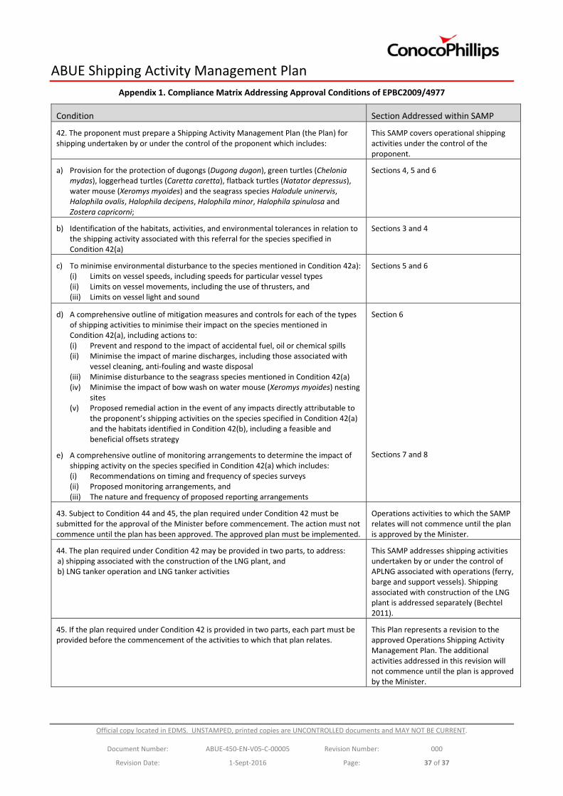
ABUE Shipping Activity Management Plan
Official copy located in EDMS. UNSTAMPED, printed copies are UNCONTROLLED documents and MAY NOT BE CURRENT.
Document Number: ABUE‐450‐EN‐V05‐C‐00005 Revision Number: 000
Revision Date: 1‐Sept‐2016 Page: 37 of 37
Appendix 1. Compliance Matrix Addressing Approval Conditions of EPBC2009/4977
Condition Section Addressed within SAMP
42. The proponent must prepare a Shipping Activity Management Plan (the Plan) for shipping undertaken by or under the control of the proponent which includes:
This SAMP covers operational shipping activities under the control of the proponent.
a) Provision for the protection of dugongs (Dugong dugon), green turtles (Chelonia mydas), loggerhead turtles (Caretta caretta), flatback turtles (Natator depressus), water mouse (Xeromys myoides) and the seagrass species Halodule uninervis, Halophila ovalis, Halophila decipens, Halophila minor, Halophila spinulosa and Zostera capricorni;
Sections 4, 5 and 6
b) Identification of the habitats, activities, and environmental tolerances in relation to the shipping activity associated with this referral for the species specified in Condition 42(a)
Sections 3 and 4
c) To minimise environmental disturbance to the species mentioned in Condition 42a): (i) Limits on vessel speeds, including speeds for particular vessel types (ii) Limits on vessel movements, including the use of thrusters, and (iii) Limits on vessel light and sound
Sections 5 and 6
d) A comprehensive outline of mitigation measures and controls for each of the types of shipping activities to minimise their impact on the species mentioned in Condition 42(a), including actions to: (i) Prevent and respond to the impact of accidental fuel, oil or chemical spills (ii) Minimise the impact of marine discharges, including those associated with
vessel cleaning, anti‐fouling and waste disposal (iii) Minimise disturbance to the seagrass species mentioned in Condition 42(a) (iv) Minimise the impact of bow wash on water mouse (Xeromys myoides) nesting
sites (v) Proposed remedial action in the event of any impacts directly attributable to
the proponent’s shipping activities on the species specified in Condition 42(a) and the habitats identified in Condition 42(b), including a feasible and beneficial offsets strategy
e) A comprehensive outline of monitoring arrangements to determine the impact of shipping activity on the species specified in Condition 42(a) which includes: (i) Recommendations on timing and frequency of species surveys (ii) Proposed monitoring arrangements, and (iii) The nature and frequency of proposed reporting arrangements
Section 6
Sections 7 and 8
43. Subject to Condition 44 and 45, the plan required under Condition 42 must be submitted for the approval of the Minister before commencement. The action must not commence until the plan has been approved. The approved plan must be implemented.
Operations activities to which the SAMP relates will not commence until the plan is approved by the Minister.
44. The plan required under Condition 42 may be provided in two parts, to address: a) shipping associated with the construction of the LNG plant, and b) LNG tanker operation and LNG tanker activities
This SAMP addresses shipping activities undertaken by or under the control of APLNG associated with operations (ferry, barge and support vessels). Shipping associated with construction of the LNG plant is addressed separately (Bechtel 2011).
45. If the plan required under Condition 42 is provided in two parts, each part must be provided before the commencement of the activities to which that plan relates.
This Plan represents a revision to the approved Operations Shipping Activity Management Plan. The additional activities addressed in this revision will not commence until the plan is approved by the Minister.