ABROLHOS ISLANDS ARCHAEOLOGICAL SITES: INTERIM...
40
ABROLHOS ISLANDS ARCHAEOLOGICAL SITES: INTERIM REPORT EDITED BY MYRA STANBURY WITH CONTRIBUTIONS BY PATRICK BAKER JOCHEN FRANKE JEREMY GREEN MARIT VAN HUYSTEE JULIETTE PASVEER CORIOLI SOUTER CLIVE TOLLEY
Transcript of ABROLHOS ISLANDS ARCHAEOLOGICAL SITES: INTERIM...

ABROLHOS ISLANDS ARCHAEOLOGICAL SITES: INTERIM REPORT
EDITED BY MYRA STANBURY
WITH CONTRIBUTIONS BY PATRICK BAKER
JOCHEN FRANKE JEREMY GREEN
MARIT VAN HUYSTEE JULIETTE PASVEER
CORIOLI SOUTER
CLIVE TOLLEY

ABROLHOS ISLANDS ARCHAEOLOGICAL SITES: INTERIM REPORT

ABROLHOS ISLANDS ARCHAEOLOGICAL SITES:
Cl) en m Cl) Cl) m a. Cl) Cl) 0 G
Hadda•
Traitors Is.
o= ~
Three Slaters (rocks)
Inner Reef survey area
Anchor•
Batavia 0
INTERIM REPORT
\ North Rocks
a
Seal Is. A
0 0 Locality Plan
\·. ..
W. A .
Ocean
Edited by Myra Stanbury
with contributions by
Patrick Baker J ochen Franke Jeremy Green
Marit van Huystee Juliette Pasveer
Corioli Souter Clive Tolley
Australian National Centre of Excellence for Maritime Archaeology Special Publication No. 5 .
Published with the assistance of Coastcare - a cooperative Commonwealth, State and Local Government program supporting communities caring for our coast.

First published in 2000 by the Australian National Centre of Excellence for Maritime Archaeology Western Australian Maritime Museum Cliff Street Fremantle Western Australia 6160
Editorial Board: Jeremy Green, Myra Stanbury Typeset by Jeremy Green Printed by P.K. Print, Hamilton Hill
This book is copyright. Apart from any fair dealing for the purposes of private study, research, criticism, or review, as permitted under the Copyright Act, no part may be reproduced by any process without written permission. Enquiries should be made to the publisher.
©The Australian National Centre of Excellence for Maritime Archaeology
National Library of Australia Cataloguing-in-Publication Abrolhos Islands Archaeological Sites (2000 : Fremantle, WA).
Abrolhos Islands Archaeological Sites: Interim Report.
Bibliography. ISBN 1 876465 12 3
l. Batavia (Ship). 2. Excavations (Archaeology) - Western Australia - Houtman Abrolhos. 3. Human remains (Archaeology) - Western Australia - Houtman Abrolhos. Forensic anthropology - Western Australia - Houtman Abrolhos. 5. Shipwrecks - Western Australia - Houtman Abrolhos. 6. Houtman Abrolhos (W.A.) Antiquities. I. Stanbury, Myra. II. Baker, Patrick, 1943-. Ill. Coastcare (Program). IV. Australian Centre of Excellence for Maritime Archaeology. (Series : Special publication (Australian Centre of Excellence for Maritime Archaeology) ; no. 5) .
994.12

Contents Contents ...................................................... .. ................ ....... .... .... ....... ............................. .... ............................................. v List of figures ............. .... ................. ... ..... ... ... ..... ................................ ..... ..................... .... .... .. ... ... .... ....... .. ............ ... ........ . v List of tables ................................ ....... ..... ... ... .. ... ............ .......... ................... .. ...... ...... ....................... ................ ..... ... ... ...... v Coastcare: Abrolhos Islands Project 1999: Myra Stan bury ......................................... .. ..... .. ............. ........ ....... .. ... .......... 1 Archaeology: Juliette Pasveer ............................. ...... ..... ..... .... .... ............... .................................. ................ ......... ... ... ...... 5 Historical evidence of the Batavia mutiny: Beacon Island expedition: Marit van Huystee ....................................... 11 Batavia site mapping:Jochen Franke .. .... .... ..... .... .... .... ...... ...................... .. ...................... ....... ....... ...... ..... ...... ... ..... ..... . 15 Batavia surveying project: J eremy Green ..... .. ..... ... .. ....... ...... ..... ... .... ............................ ............ ... ... .... .................... ...... 19 Abrolhos geophysical survey: Corioli Souter .................................. ......... .... ..... ............ ......... .......... .... .... .... ............. .. .. 21 MAAWA Report-Beacon Island: Clive Tolley .. ... ........... .... .... .... ............ ... .. ...... ............................. .. .. .... ... ........... ..... .. 24 Appendices ..... ..... .................. ............ ...................................... .... ......... .. .... ......... ..... ....... .. ... .. ..................................... ... 25 Appendix 1: Project organisations, support groups and expedition personnel .... .......... .. .. ...................................... 25 Appendix 2: Volunteer information and check list sheet.. ................................... .............. .... ................... .. .. .. .. ... ..... .. 26 Appendix 3: Beacon Island excavation 1999 photographic records: Patrick Baker ... ..... .. .. .... .. ... .. .. .... ...... ......... .... .. 31 Appendix 4: Post-recovery care and on-site storage of artefacts ... ......... ............................ ......... .................. ............... 33 Appendix 5: Media and publicity ................... ... ............ .. ......... .... ................... ..... ..... .......... ... ... .... ........ ... ... ...... .. .... ...... 33 Acknowledgements ........... .. ..... .. .. ..... ... ..... .. .... .. .. ..... ........................ ......... ............................... ... .. .. .... ...... .... .... ....... ....... 33 References ......................... ...... .... .... ....................... .. ............................... .. ..................... .. ............................. ..... ....... ..... . 34
Figure 1. Figure 2. Figure 3. Figure 4. Figure 5. Figure 6. Figure 7. Figure 8. Figure 9. Figure 10. Figure 11. Figure 12. Figure 13. Figure 14. Figure 15. Figure 16. Figure 17. Figure 18. Figure 19. Figure 20. Figure 21.
Table 1.
List of Figures Illustrations from the 1647 Jan jansz book Ongeluckige Voyagie van 't Schip Batavia .. ...... .............. .. .. .. ... 4 Excavation grid and the excavated area ...... .... ...... .... .. ... .... ... .............. ... ........... .. .... ...... ...... .. ..... ..... .. .... .... 6 The mass grave ...... ............................... " ... ....... ....... ... .......... ........ .. .. .... ..... ..................... .. ... ..... ........ ...... ... .... 7 Some of the metal buttons found during the excavation ........................................ ............ .............. ...... 8 Illustration from theJanJansz book of 1647 showing the massacres on Beacon Island ..... .. .... ..... ...... 10 Illustration from theJanJansz book of 1647 showing the attack on Webbie Haijes Island .... .. .... ..... .. 13 The Total Station survey team at work .. ......... ... ..... ... ...... .... .... ... ...... ..... ....... ....... ...................... ...... ........ 15 Trimble 4000 SSI Static CPS station setup on Beacon Island (BEl) ......... ..... ... ......... .. ..... ....... ... ....... ... 16 Example of a target cross-this particular one was placed on Hall Island ................................ ....... ...... 16 The imaging system over the site ..... ..... ... ........................ ... ....... ..... .. ... ............................................. ....... 17 Aerial view of the site. The photo shows Beacon Island in the centre, Traitors Island to the left ... ... 17 Total Station survey of targets placed on the excavation site ... ...... ........ ........ ......... .... ......... ... ... .......... .. 18 Map of the Eastern Islands of the Walla bi Group form GIS data .. .... ................. ........ ........ ... ........... ..... 19 PhotoModeler view of grave site showing targets, photograph taken using digital camera ... ..... ........ 20 Interim plan of grave site targets and skeletal material using PhotoModeler .. ......... ....... .. .. ..... .. ....... .. 20 Juliette Pasveer and Greg Joyce discussing the CPR image of the grave site .... ... .. ...... .. ... .... ........ ... .... . 22 Adam O'Neill assisted by MAAWA volunteer, Holly Cassin, using the Pulse Echo 100 CPR ..... ..... ..... 22 CPR survey of the Ashplant yard using the Surface Impulse Radar-System 2 (SIR 2) .. .. .. .......... .... ..... 22 Corioli Souter down-loading magnetometer data on-site .. .................................................................... 22 Geoff Kimpton and Holly Cassin deploying magnetometer over Ashplant yard ... ... .. .. ... .. ... ... .......... .. 22 Image from SIR2 CPR over the grave site .......... .... ... ........................ .. ................. .... ........ .. ..... ....... ......... 23
List of Tables Brief summary of the events concerning the Batavia Mutiny (1629) ..... ....... ..... .... ..... .. ...... ... .... .. ...... ... 14
v

Coastcare: Abrolhos Islands Project 1999 Myra Stanbury
Introduction
The Houtman Abrolhos Islands The Houtman Abrolhos Islands and the waters which surround them are important to many sectors of the Western Australian community. As the Minister for Fisheries, the Hon. Monty House MLA, states in the Minister's Foreword to Management of theHoutmanAbrolhos System (Fisheries WA, 1998), they are of ' distinct environmental and historical significance and have 'high economic and social value'. Demand for use of this unique environment is placing the Abrolhos Islands ecosystem under increasing pressure. Careful and coordinated management is required, therefore, to ensure that those features which make the Houtman Abrolhos unique are protected for the future.
The islands are an A-Class reserve (A20253) vested in the Minister for Fisheries for the conservation of flora and fauna, tourism and purposes associated with the fishing industry. They are managed by Fisheries WA under regulations established pursuant to the Fish Resources Management Act 1994 (WA). A plan, Management of the Houtman Abrolhos System (Fisheries WA, 1998), was published in December 1998 with proposed strategies ('immediate' and 'ongoing') to address marine and terrestrial management issues at the Abrolhos Islands.
The primary management goal is:
To conserve the environment of the Abrolhos Islands for present and future generations, as a viable ecosystem, by protecting natural diversity, cultural heritage and ensuring ecologically sustainable use (Fisheries WA, 1998: 19).
Role of the Western Australian Museum As stated in the management plan:
TheAbrolhoslslands are a unique part of Australia's heritage, with a violent and colourful past. There is increasing interest in the historical, archaeological, cultural and heritage values oftheAbrolhoslslands ... [and] ... asignificantrecentincrease in the numbers of people making the effort to visit historic
sites (Fisheries WA, 1998: 65) .
The Western Australian Museum has administrative responsibilities for the State's Maritime Archaeology Act 197 3 and the Commonwealth Historic Shipwrecks Act 1976. These Acts effectively combine to protect valuable State and Commonwealth maritime heritage sites, both above and below the water. The Department of Maritime Archaeology at the Western Australian Maritime Museum,
Freman tie, is entrusted with the responsibility of managing State and Commonwealth protected historic shipwrecks and associated historic sites on land throughout Western Australia.
The Abrolhos Islands are noted for some of the most important maritime archaeological sites in Australia, sites which are internationally significant and a major attraction for visitors to the islands. The complex of sites in the Wallabi Group associated with the loss of the Dutch East-IndiamanBataviain 1629, and the fate ofitssurvivors, are among the most well known. They represent some of the oldest European habitation sites in Australia. Yet surprisingly they remain poorly understood.
Many of the archaeological sites in the Abrolhos Islands have suffered with the passage of time, and uncontrolled access. Souvenir hunting, fossicking, metal detector probes, removal and/ or 'reconstruction' of standing structures, and unauthorised 'diggings' have resulted in considerable loss of archaeological information. This results in a confused rather than a clear picture of what actually happened in the past.
During the developmental phases of the planning strategy for the Houtman Abrolhos, it was recommended that:
Further research into archaeological and historical sites on and around the islands is to be encouraged (Abrolhos Islands Task Force, 1988: 23).
Acting on that recommendation, the Western Australian Maritime Museum has systematically sought funding from various research and heritage organisations to carry out research investigations of significant maritime heritage sites in the Abrolhos Islands. Further supported by recommendations from the Australia Netherlands Committee on Old Dutch Shipwrecks (AN CODS) (Green, Stanbury & Gaastra, 1998), one of its principal aims has been to undertake a comprehensive survey, evaluation and limited excavation of selected sites associated with the survivors of the Batavia.
Although extensive archaeological work has been undertaken by the Museum on the Batavia underwater site (see Green, 1989), the associated land sites have not received the same degree of attention. Small mapping projects and test excavations have been carried out on some of the islands with the aim of recording and verifying the location of previously reported finds (see Stan bury, 1998). However, new systems of surveying now allow these sites to be positioned more accurately. Furthermore, non-destructive, remote-sensing technology, such as Ground Penetrating Radar, has the potential to locate

AUSTRALIAN NATIONAL CENTRE OF EXCELLENCE FOR MARITIME ARCHAEOLOGY SPECIAL PUBLICATION NO. 5
new and possibly undisturbed archaeological remains which could reveal new research information about the historical events which took place in the Abrolhos centuries ago.
Modern scientific and forensic techniques, not available when the Batavia was first located in the 1960s, can now assist archaeologists in their analyses and interpretations, particularly with regard to human osteological (skeletal) material. Existing evidence, and new data, can be treated in much more sophisticated ways, opening up new vistas on the past.
Sir Mortimer Wheeler maintained that 'archaeology is digging up people, not things', meaning that it was important to use the artefacts found in excavations to bring to life the people who made and used them (Wheeler, quoted in Prag & Neave, 1997: 11). In recent times, his precept has been taken one step further: techniques are now available which enable the facial ch<uacteristics of ancient human skulls to be reconstructed, giving historical figures a lifelike identity. Although the reconstruction may not be a totally accurate representation of how the person appeared in real life, scientific developments in the field of cranio-facial reconstruction have led to the production of credible likeness when images of known historical persons have been compared with the reconstruction.
The combination of stereolithography and Computer Tomography (CT), or three dimensional (3-D) X-ray images, is enabling complex archaeological material, such as skulls and other skeletal material, to be replicated with a degree of accuracy and detail not obtainable by conventional replication methods (see Arnold III & McAllister, 1998). The diagnostic features of the skeletal components can be stored on computer, forming a permanent part of the archaeological record for a particular individual(s). The data can be used at any time to view the skull or other bone from any perspective and to make prototype models for casting and facial reconstruction. Experimental work using this technique has been undertaken successfully on the remains of a French sailor whose remains were recovered in 1996 from the hold of the wreck of Rene-Robert Cavelier Sieur de La Salle's supply ship the Belle, lost off the coast of Texas in 1696 (see Hamilton, 1997). La Salle was endeavouring to establish a French colony along the Gulf coast.
Similarly, recent developments in DNA testing have opened up a new area of study called 'molecular archaeology' (Blau, in Zarmati & Cremin, 1998: 144). This potentially allows archaeologists to trace the genetic relatives of the ancient bodies they have discovered, possibly even establishing links between ancient and modern people. In this way, they are able to come another step closer to meeting the historical people they are studying. This technique, too, is being used on the La Salle victim in the hopes that the DNA profile may link this individual to modern relatives (Hamilton, 1997). Similar studies are proposed for skeletal remains recovered
2
from the British Admiralty ship HMS Pandora, wrecked in 1796 off the coast of north Queensland (Gesner, P. and Steptoe, D., 1999, pers. comm.).
The Coastwest/ Coastcare Abrolhos Islands Project A Coastwest/ Coastcare grant was awarded to the Western Australian Maritime Museum, Fisheries WA and associated government agencies and community groups to assess the extent of the archaeological evidence relating to the Batavia (1629) incident in the Wallabi Group, Houtman Abrolhos. Having evaluated the evidence, the project will make management recommendations and implement strategies to ensure that the heritage content of the sites is protected and, at the same time, accessible for the benefit of the public. The objective is to improve interagency cooperation, and provide both increased information to visitors and community involvement in management.
As outlined in the First Phase Planning document (Green, 1999), circulated to participating organisations and community groups, the first phase of the project involved a fieldwork component in the Abrolhos focussing on two aspects: archaeology and survey.
This Interim Report aims to provide a brief outline of the organisation of the project, the work carried out and preliminary results.
Project organisation The Abrolhos Islands Project was initiated as a JOmt undertaking between the following government agencies and community groups, each offering support and assistance with the planning and logistics, field operations and volunteer labour: • Western Australian Maritime Museum • Fisheries WA • Conservation and Land Management (CALM) • GeraldtonProfessionalFishermen'sAssociation (GPFA) • Maritime Archaeological Association of
WesternAustralia (MAAWA) In addition, a number of volunteers and professional consultants were drawn from private enterprise, tertiary institutions, other government agencies and community associations including: • Curtin University of Technology • Geraldton TAFE • University of Western Australia • Queen Elizabeth II PathCentre • PRISM Australia • Batavia Coast Maritime Heritage Association • Fisheries WA: Volunteer Group A complete list of personnel involved in the project is given in Appendix 1. A total of 31 persons directly participated in the field operations.
The project team was based on Beacon Island during the three-week field season from 25 September to 16 October 1999. They were accommodated in 'Dransfield House' (courtesy Fisheries WA) and in private camps

ABROLHOS ISLANDS ARCHAEOLOGICAL SITES: INTERIM REPORT
belonging to Beacon Island fishermen (courtesy Rod Dransfield and john Ashplant).
A core team of Museum personnel and 'permanent' volunteers remained on the island for the duration of the expedition, additional assistance being provided by changing teams of volunteers, specialists and media personnel on a weekly basis. The first group travelled from Geraldton to Beacon Island on the Fisheries patrol boat PV Walcott under the command of Quine Parkes, with crew Bruce Webber, Garry Johannesen and Murray Verne. After assisting the pearling lugger Willie to return to the Gerald ton wharf to attend to mechanical problems, the team arrived at Beacon Island in about 31/ 2 hours.
All equipment, personal gear, food, and other supplies, including the Department of Maritime Archaeology's dive boat Seaspray, had to be brought to Geraldton from Freman tie by road, and similarly returned. Towing services for Seaspraywere provided by Accredited Towing Services. At Geraldton, volunteers assisted Museum and Fisheries personnel with the loading of the Walcott and became quite familiar and adept with the process of packing, loading, unloading and unpacking gear throughout the expedition. The return trip on the Southern Lady, skippered by Bevan Suckling with crewman Nick Linton was a somewhat slower voyage, with less favourable sea conditions.
Intermediate changes of teams were made by air charter (Shine Aviation) between Geraldton and East Wallabi Island, Seaspray, skippered by Geoff Kimpton, ferrying passengers to and from Beacon Island. Fortunately, weather and sea conditions on transfer days were in our favour and planned schedules were able to be maintained. Ray Howarth, skipper of the supply I charter boat Island Leader, also assisted with the transport of sensitive technical equipment too heavy to be flown to Beacon Island.
All participants were given a briefing document in advance of the expedition (see Appendix 2) together with Volunteer Worker Indemnity Forms as required by the Museum. Emphasis was placed on the unique nature of the Abrolhos System and protective policies applicable to the area, together with general advice as to weather, accommodation, safety and personal requirements.
Many of the volunteers had never been to the Abrolhos Islands before; living a relatively Spartan existence on a small island was a new experience. In addition to assisting with the various project activities, all personnel were rostered to share with the catering and general camp duties-recycling rubbish and managing the intricacies of the composting toilet. For some, even cooking was a first-time event!
Each group consisted of men and women of differing ages and diverse backgrounds rep re sen ting a broad range of skills and expertise. This proved to be one of the most beneficial aspects of the project; everyone had something valuable to offer, whether it was technical expertise in one form or another, or simply a delicious new recipe to
3
sustain the workforce. Working days commenced with a meeting at 0800 (following breakfast), to plan and discuss the day's activities; this was important in order that everyone clearly understood what was happening. Apart from the project leaders and volunteers assigned to specific projects, all expedition volunteers were given the opportunity to participate in a variety of tasks so that they were not permanently assigned to the same job. Evenings, particularly those spent around the barbecue, proved to be an extremely sociable time and generated a good team spirit.
Many of the volunteers maintained their own personal journals, MAAWA members being specifically asked by their association to do so in order that these accounts can contribute to the final Coastcare report.

AUSTRALIAN NATIONAL CENTRE OF EXCELLENCE FOR MARITIME ARCHAEOLOGY SPECIAL PUBLICATION NO. 5
Figure 1. Illustrations from the 1647 Janjansz book Ongeluckige Voyagie van't Schip Batavia. Above the events leading to the wreck, below the final fate of the mutineers.
4

Archaeology Juliette Pasveer
Introduction In the late 1980s human bones were located during the digging of a trench for a leach drain in the backyard of a fishing camp on Beacon Island, currently licensed to the Ash plant family, but occupied in the 1960s byMrO. 'Pop' Marten who made the accidental discovery of the first of a series of skeletons on the island. Unbeknown to him at that time, he had also discovered, in the vicinity of his camp, thefirstdatedobjectfrom the Batavia-an engraved brass trumpet garland marked with the Roman numerals for the year 1628 (see Halls, 1964: 25; Stanbury, 1998: 108). Although some of the local fishermen had knowledge of curiously-shaped objects on the sea-bed at a site on nearby Morning Reef, it was not until 1963 that this proved to be the remains of the voe Retourschip Batavia, wrecked on 4June 1629.
News of the discovery of the underwater site led to a frenzy of 'digging' and uncontrolled excavations on Beacon and other islands in the Wallabi Group (see Edwards, [1966] 1973: 169; Stanbury, 1998: 107-108). Searches uncovered various items including broken ceramics, beads, metal objects, faunal assemblages etc., and more human remains. In recent years, the collection of Batavia human skeletal material held at the Western Australian Museum, Geraldton Region Museum, the Australian National Maritime Museum and the Nederlands Scheepvaart Museum, Amsterdam, has been subject to intensive re-investigation as new analytical techniques have become available. The combined expertise of physical and forensic anthropologists, historians and others has greatly expanded the existing body of knowledge of the victims of the Batavia mutiny and continues to do so (see Pasveer, et al., 1998; Amalfi, 1999).
The bones, including some skull fragments, unearthed in the 1980s, were put back into the trench and covered up when the drain was finished. The Museum was not informed about the finds until a Commonwealth Historic ShipwrecksAmnestywas declared in 1993-94. This allowed people to make reports withoutfear of prosecution under the Historic Shipwrecks Act 1976 and to declare any unregistered cultural material that they might havv in their possession.
Unfortunately, in this instance, the site had already been subjected to vandalism, some bones having been reportedly removed. In 1994, a small team from the Western Australian Maritime Museum, led by Myra Stan bury, went to the island to investigate the site and to assess the extent of the damage. For this purpose a small test pit was dug (about 4 m 2) and some scattered skeletal remains were found and taken back to the Museum to be
5
curated and studied. From these remains it was established that there were at least three individuals (two adults and a child) buried at the site (Hunneybun, 1995; Pasveer, et al., 1998).
The degree of prior human disturbance and ongoing disturbance by local wildlife (especially various species of mutton birds), together with the riskoffuturevandalism led to the decision to fully excavate the site. This would also provide an opportunity to extend the research on the historical skeletal remains.
The results presented here should be considered preliminary, as the finds are still in the process of being cleaned, identified, catalogued and restored.
Excavation methods Weeds and a c. 1 m strip of bushes and shrubs at the southern edge of Ashplant's backyard were removed to provide access to the area of the 1994 test excavation (Gibbs, 1994). An excavation grid was set up starting from this location, and extended over most of the surface of Ash plant's backyard (see Fig. 2). The excavated squares are D4 and E4 (the southern halves), D5 and E5, D6 and E6. This covers the area of the 1994 excavation, p lus an extension of 0.5 m in a southerly direction. The squares excavated in 1994 have been renamed to conform with the new and larger grid system. Excavation was done in square metres, but to relate the grid to the area excavated in 1994, only half the square was excavated in some cases.
The squares were excavated in 5 cm spits (designated depths of soil), except in those areas which had already been excavated in 1994. All removed soil was sieved in both a 5 mm and 3 mm sieve, and the residues were searched on site for archaeological material. Recent domestic materials (old batteries, plastics, nails, broken pegs, etc.) were properly disposed of. Finds were extensively filmed, photographed and drawn (see Franke & Green, this report) . The exact location of every find was three- dimensionally measured. All finds were removed, with the exception of a deposit of dense, black soil of uncertain origin and significance (see further discussion); this was left in situ and covered with black plastic and coral slabs, for protection, before the pit was back-filled with the sieved deposit. The excavation area was finally regreened.
Excavation was done under the cover of a tarpaulin not only to protect the excavated material from the sun and rain, but also to allow excavation to continue regardless of the weather. The bones were continuously sprayed with fresh water to prevent them from drying out too quickly. After removal, all finds were allowed to dry slowly, wrapped in pH neutral paper within unsealed
AUSTRALIAN NATIONAL CENTRE OF EXCELLENCE FOR MARITIME ARCHAEOLOGY SPECIAL PUBLICATION NO. 5
N
water tank Ashplant's house
water tank E D c B A
1
2 I H G F y
3
E+S 04-S 4 Ashplant's house
- -\
ES t;>s ' I
~, ,:...., -!:"'::_ --1 ' ..... ,,
D 1999 excavation
D 1994 excavation
=- = leach drain
X Hill 's Hoist
' - ~ approximate grave contour
Figure 2. Excavation grid and the excavated area.
bushes
plastic bags, and then packed for transport (see Appendix 4).
The finds The excavated area contained five individuals (named SK7, 8, 9, 10 and 11), with most bones still in anatomical position. The individuals were all located in a circular pit and had been laid curved against each other. The head and shoulder region of two individuals had been damaged during construction of the leach drain. The remains that were found in 1994 (SK5 and SK6) are considered to belong to these individuals. Three of the individuals are adult, two are children of about 12 and 5 years old. The bodies were found to lie over, under, or in a large deposit
6
- - -
5
6
l m
of black, dense soil penetrated by numerous fine roots. The nature of this deposit is currently being investigated. Embedded in this black deposit were metal buttons, some fibrous material and impressions of woven, fibrous material, which may indicate the presence of fabric. Since this black deposit obviously needed special care and investigation it was left in situ for future excavation.
Because some bones were firmly embedded in the black deposit they could not be removed. Those which were removed from this material proved to be very damp and less well preserved than those bones located in the surrounding sand. It is likely, therefore, that any bone material remaining in the black deposit will be in a very poor condition. As the black deposit was found amidst

ABROLHOS ISLANDS ARCHAEOLOGICAL SITES: INTERIM REPORT
Figure 3. The mass grave. The bones of the 5-year-old child (SK9), originally located against the back of the adult skeleton (SK7), had to be removed at an early stage of the excavation.
the individuals, most of the recovered skeletons are currently incomplete.
The individuals SK7 is an adult skeleton of a man in his early twenties. His body is almost complete, but some bones had to be left in situ as they were embedded in the black material. The sex is convincingly determined on the basis of the skull and the robustness of the bones in general; the pelvis is too incomplete to add any useful information. The initial age estimate is based on the tooth wear, and will be further assessed when all bones have been cleaned. The individual was buried more or less on his right side, legs slightly flexed, head facing down and his left arm folded underneath his body (protruding into the black soil). His right arm was positioned alongside his head with the lower arm folded underneath.
SKS is the body of a 12 to 13-year-old child. Most of the bones above the pelvis were found in anatomical position, but the pelvis and any other bones below that are embedded in the black soil and could not be removed. It is possible that they are completely deteriorated. The age of this individual was determined on the basis of tooth eruption and the fusion of the bone epiphyses (none of which are fused). It is not possible to determine the sex of juvenile individuals on the basis of bone morphology, because the sex-specific features in the skeleton have not
7
yet developed fully; hopefully, a DNA analysis will reveal whether this child was male or female. The child was buried on its right side, the head facing down but slightly on its right side. In the region of the rib cage numerous buttons were found, in situ, in a row from the chin down along the chest. Buttons were also found in the wrist area of the left arm. These buttons are currently being cleaned and investigated. Historical research may hint at the kind of clothes they may have been attached to.
The body of the 5-year-old child (SK9) is incomplete because it was severely disturbed by mutton bird activity. The skull was badly crushed due to the pressure of the soil and, because it was undermined by a mutton bird hole, it had to be removed at a very early stage of the excavation. Though the bones were scattered, the original position of the body is clear, namely laid against the back of the adult skeleton SK7, probably right side and face down, in the same flexed position. The tooth eruption and the size of the bones indicate that the child was between 5 and 6 years old when it died. The sex will have to be determined with DNA analysis.
The bones of the skeleton of SKlO are in a very bad condition. The head and shoulder region were damaged and disturbed by the digging of the sewer trench, and only the very fragile rib cage and vertebrae were recovered. The remainder of the body was embedded in the black deposit and probably is also in a bad condition. Some isolated leg,
AUSTRALIAN NATIONAL CENTRE OF EXCELLENCE FOR MARITIME ARCHAEOLOGY SPECIAL PUBLICATION NO. 5
Figure 4. Some of the metal buttons found during the excavation.
hand and foot bones may also belong to this individual. The position of this body is presently uncertain. It belongs to an adult individual of an, as yet, unknown age and sex.
The skeleton of SKI 1 also is very incomplete; again, the head was removed by the digging of the trench, and most of the body from the pelvic region and below is embedded in the black deposit. The rib cage and the left arm, however, are in a relatively good condition. This individual was buried on its back but tilted slightly to the right side, with the left arm folded over the chest. In the shoulder region a bright green stain is present on some of the ribs and part of the shoulder blade. This is indicative of the presence of copper, although no large copper alloy objects were found in the area. The skeleton belongs to an adult individual of, as yet, unknown age and sex.
The skull labelled SK6 was located in 1994 and then left where it was found by the excavator. It was removed during the 1999 excavation. The skull was found out of original context, not associated with any post-cranial bones, and surrounded by modern materials (batteries, plastic etc.) . It is obvious that this was one of the skulls that was removed and then reburied during digging of the sewer trench. The skull is incomplete and cracked but the bone is in reasonable condition. The crack was possibly caused by a blow on the head, reopening the suture on the right side of the skull (Buck, A. & Cooke, C., 1999, pers. comm., 5 Nov.). Also, the right upper incisor has been forced into the bone of the upper jaw. This is likely to have been caused by a heavy blow against the teeth. It is possible that both the dislocated tooth and the crack in the skull are the result of violence. Skull SK6 probably belonged to a male individual in his early twenties.
The skull fragments of SK5 were recovered in 1994 and have been subject to prior study (Hunneybun, 1995; Pasveer, 1997; Pasveer et al., 1998). They probably belong to an adult individual of around 40-45 years old. The sex could not be determined.
It is very likely that SK5 and SK6, along with some other post-cranial bones recovered in 1994, belong to
8
SKlO and SKll of the 1999 excavation. However, at present it is not clear which skull might belong to which skeleton. As both age determinations of SK5 and SK6, and the sex determination of SK6 are only based on incomplete skulls, these determinations must be considered as preliminary.
Metal Various pieces of old and more recent metal objects were found in situ or in the sieve residues. The study of these metal artefacts is at a very early stage.
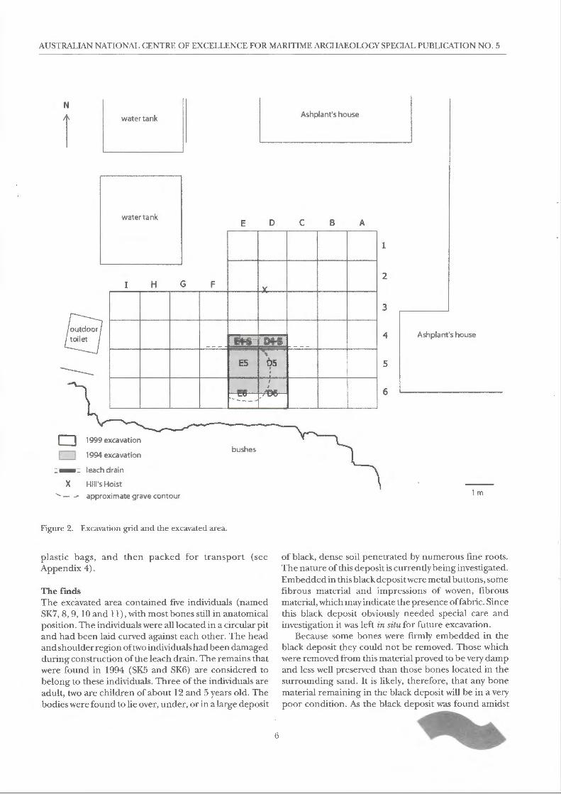
Nineteen metal buttons were found, most of them in situ, but some in the sieve residue. A row of buttons was found close to the rib cage of the 12-13-year-old individual SK8, extending from the chin down across the chest. A few also were discovered in the wrist area of the left arm. These buttons obviously come from the clothes that the child was wearing when it died, and may tell us something about the kind of clothing that was worn in those days. Most of the buttons are heavily encrusted, but a few show a very finely decorated pattern (Fig. 4).
Several decorated and plain brass buttons with loop shanks, similar to those recovered from the Beacon Island site, have been found among the shipwreck remains, many of them embedded in iron concretions (see Green, 1989: 174, ill. BAT 565A). Others of brass and silver were found on Gun Island in the Pelsaert Group of the Houtman Abrolhos where the survivors from the VOC ship Zeewijk spent nine months in 1727 (see Ingleman-Sundberg, 1978: 37), and, a finely decorated silver button survived the ravages of the Zuytdorpwreck in 1711. Several varieties of buttons and other clothing accessories have been excavated from 17th century sites in Amsterdam (Baart, et al., 1977) and serve as comparative examples.
A piece of very fine copper wire was found in the sieve residue. This fragment is obviously manufactured and modified into a very small circular object (c. 5 mm in diameter) and is bent in places into very curved loops. Its identity is unclear, but suggestions are that it may have formed part of a piece ofjewellery, for holding a gemstone, or simply functioned as a decorative device. This clearly needs to be studied further.
Some fragile pieces of copper wire were also found during the cleaning of one of the shoulder blades of individual SKI 1. These are curved, as if part of a very thin chain or necklace.
A small fragment of pewter was found on the rib cage of individual SK7. (This unfortunately cracked into three pieces before it was raised from the site.) The fragments fit to form part ofa spoon, similar to those recovered from the wreck of the Batavia (see illustrations in Green, 1989: 153). One fragment shows the point, on the reverse of the bowl, where the handle would have been attached (see Green, 1989: 153, ill. BAT 7092).
Finally, a small metal buckle was found in the sieve. Its age or association is currently undetermined.

ABROLHOS ISLANDS ARCHAEOLOGICAL SITES: INTERIM REPORT
Glass Two glass bottles were found in the area outside the burial pit. This area contained scattered remains of modern rubbish. The bottles appear to date from this century. One bottle (BILS 220) has the embossed letters 'ACM' on the base indicating that it was made by the Australian Glass Manufacturing Company Limited (see Arnold, 1985: 25-34; 1987: 8; Boow, 1991: 176). The company was originally established in Melbourne as the Melbourne Glass Bottle Works (MGBW) but following an amalgamation with the Waterloo Glass Bottle Works Company Limited, in 1915, changed its name to Australian Glass Manufacturing Company Limited; it is now part of Australian Consolidated Industries (ACI). Raised letters and symbols created on the glass through use of full-size moulds, either blown, pressed, or machine-made was the most common form of commercial marking on containers and tableware in the 18th and 19th centuries (see Jones & Sullivan, 1989: 16).
The letter 'A' has a square top, with the left arm slightly shorter than the right; both are slightly concave. The letter 'G' is set above the cross bar of the 'A; with the letter 'M' below (see Arnold, 1985: 27). The style of the ACM mark changed over time and allows the bottle to be dated to the period c. 1930-1948 (see Arnold, 1985: 27), although it continues in a similar form to date (Boow, 1991: 176).
Adjacent to the ACM the bottle is marked 'F 1855 ( 627 vertical) M'; either side of the 1855 are the numerals 'O' and '8'. These probably relate to the mould number in the set, the design number and the factory of origin (e.g. 'M' for Melbourne) (see Boow, 1991: 176).
Bottle BILS 220 (ht c. 153 mm; base 60 x 28 mm) is a colourless, rectangular moulded bottle with slightly concave sides, each with three circular indentations. The finish is externally threaded to accommodate a patent bakelite screw cap of 23 mm diameter. The bore consists of a small, circular opening, seemingly designed to restrict the flow of contents from the bottle. The top of the bakelite cap bears an embossed monogram formed from the letters 'CMCO', probably the trade mark of the company producing the contents. Remains of the contents-an oily, yellow substance/residue-suggest a toiletry product such as hair oil/restorer. Inside the cap are the remains of a dark brown, oily, 'fibrous' material, possibly remnants of an internal seal.
The second bottle (BILS 132) is a brown glass, moulded bottle (ht 147.5 mm). The body is Philadelphia ovalshaped (see Jones & Sullivan, 1989: 101, fig. 68) with scooped shoulders (Jones & Sullivan, 1989: 99, fig. 66) and an externally threaded finish, sealed with a metal cap. An embossed numeral '6' is present on one of the chamfered sides, near the base.
These bottles are clearly intrusive finds and have no association with the Batavia.
9
Animal bone Animal remains were found in the sieve residues, but none of them have been identified yet. Most of them are probably recent, coming from native wildlife or remains of cray-pot bait. However, further study is needed to establish whether any of them are associated with the Batavia survivors.
Preliminary interpretation, planned studies and future projects The history of the leach drain illustrates how vulnerable the historical sites in the Houtman Abrolhos are to human activity, particularly when their exact location is unknown. But for such 'accidental' discoveries, sites such as that presently under investigation might never be found at all. This emphasises the need to test various remote sensing and other survey techniques which may assist in identifying the locations of potential archaeological sites so that similar disturbance can be avoided. Once the potential location of sites is determined, management strategies can then be put in place to control development activities.
If the trench for the sewer had been dug 30 cm to the south, the damage to the existing site would have been much worse than it is now. On the other hand, had the trench been 30 cm to the north, the burial pit would have been completely by-passed with minimal or no damage being incurred. Had the location of the site been known, alternative recommendations for the placement of the leach drain could have been made.
An important result of the 1999 excavation is that the existence of a mass burial pit has been confirmed. This has important implications for the interpretation of Pelsaert's Journal; for the identification of the victims; and also for the study of behavioural aspects of the mutiny.
The position of the individuals in the burial pi tis such that they cannot be considered to have had a 'normal' Christian burial. Although indications for a violent death are not abundant, the circumstances of their burial strongly suggests that they did not die a natural death. It appears that either SKlO, or maybe SKll or SKS, were thrown into the pit first, with SK7 deposited on top. The 5-year-old child may have been laid down last, pushed tightly against SK7's back to ensure all individuals would fit into the pit. Although the relatively large deposit of black soil was not excavated, we can be quite certain that the total number of individuals in this grave is five; so far there are no indications of the presence of other individuals and most of the margin of the pit is clearly defined.
An important objective of this study is to identify the individuals. At this stage, however, no positive identifications have been made. One research hypothesis being tested is that the mass burial may be associated with the slaughter of the Predicant'sfamilyon the nightof21July 1629 (see van

AUSTRALIAN NATIONAL CENTRE OF EXCELLENCE FOR MARITIME ARCHAEOLOGY SPECIAL PUBLICATION NO. 5
Huystee, this report). However, there are several other candidates mentioned in Pelsaert's Journal who could have been buried in this way. The combined results of the historical and archaeological research, therefore, will provide essential information to support or refute the existing hypothesis, and indicate alternative interpretations.
After all the bones have been cleaned and catalogued, an attempt will be made to reassociate isolated bones to any of the individuals. Age and sex determinations will be finalised and, if necessary, radiology or DNA analysis will be applied to the bones to provide, or support, the determinations. Traces of disease and trauma will be further investigated, also with the aid of X-rays. For the identification of the individuals, DNA analysis will be applied to at least the two children, but preferably to all individuals. If this grave contains members of the Predicant's family, then at least the two children should be related. Ifwe find no genetic similarities in the bone, then other potential candidates will need to be considered.
The diet of the people is planned to be investigated using Scanning Electron Microscopy (SEM) of the teeth; stable isotope analysis of the bones; and, possible study of stomach contents (which may be evident in samples
taken from the soil in the stomach area). The metal cloth accessories need to be cleaned and studied in the context ofl 7th-century clothing. All this, in combination with the people's health and physical condition, will provide a wealth of information about general life standards in the 17th century in north-western Europe and the people on board an ocean-going ship like the Batavia.
The black deposit that was left in situ in 1999 will need to be excavated in the near future , possibly with different equipment and expertise. However, prior to excavation, it is essential to establish the organic nature of the deposit, its origin and significance, and the condition of any embedded bones or artefacts. Samples have been submitted to the Departments of Soil Science and Chemistry at the University of Western Australia for analysis.
An indication of the nature of any soluble organic components will be gained by solvent extraction and nuclear magnetic resonance (NMR) spectroscopy (see Ghisalberti & Godfrey, 1990, 1998). This technique provides information about the type of chemical functional groups and the structures of constituents present in mixtures of organic compounds.
Figure 5. Illustration from thejanjansz book of 1647 showing the massacres on Beacon Island.
10

Historical evidence of the Batavia mutiny: Beacon Island expedition Marit van Huystee
Introduction The identification of the Batavia mu tiny victims is part of a larger project of the Western Australian Maritime Museum that started several years ago under the supervision of Myra Stanbury. The project's title is 'The historical archaeology of the Batavia shipwreck (1629) survivor camps'. The project investigates historical and archaeological evidence of how the castaways of the Batavia managed to survive on the islands of the Houtman Abrolhos after the Batavia wrecked.
Two important parts of this project are the historical background and the study of the human remains found on the islands in the last three decades.
Historical evidence Practically all the historical evidence on the Batavia mutiny can be found in the PelsaertJournal, a handwritten 17th-century Dutch document, which is kept in the Netherlands (Algemeen Rijksarchief [ARA], The Hague, Document 1630: 1098 QQ II, fol. 232-316; see also Huystee, 1998).
E.D. Drok's translation of the manuscript was published in Henrietta Drake-Brockman's book Voyage toDisasterin 1963 (Drake-Brockman, [ 1963] 1995: 122 ff.). This translation, and a translation of the first book published on the Batavia disaster by William Siebenhaar (1897) at the end of the 19th century, have been used as the main sources for further historical research in Australia. Although Drok's translation in many respects is of a very high standard, there are a few instances where his translation of the Dutch text is, in my opinion, too interpretative. This is understandable, as the original text is indeed often ambiguous, especially in regard to the islands and the locations where the recorded events took place.
The Wallabi Group, Houtman Abrolhos In the Pelsaert Journal the two biggest islands in the Wallabi Group of the Houtman Abrolhos are called Batavia's Kerkhof (Batavia's Graveyard), and Robben Eiland} (Seals Island) (see Roeper, 1993: 27, fig. 5). Nowadays, these are thought to be Beacon and Long Islands. There are, however, people who have doubts even about this (see Melrose, 1998) .
We assume that Hoge Eiland (High Island) refers to both East and West Wallabi until folio 295v/ 296r (see Roeper, 1993: 172) . From this page onwards, Pelsaert starts to use the name 'Wiebbe Haijes' .2
From folio 261vonwards (Roeper, 1993: 115) a Verraders Eiland (Traitors Island) features in the text. It is not clear which island is meant here and why it is called Traitors Island. Each time Traitors Island is mentioned, it is in
11
relation to the drowning of two men on 5 July 1629, and the drowning of a group of fifteen people on 9 July. It seems that this island cannot have been far away from Batavia'sGraveyard as some of the men make an effort to save themselves by swimming to that latter island.
On folio 269r fifteen people who built two rafts were first sent to Batavia's Graveyard (from Traitors Island) by Sevanck and Van Huijssen, but when they reached the shallows of the island, they were killed. This event, like most of the more important events, is mentioned various times in the journal. Only this particular occasion, more detailed information on the location is given. The fifteen people had planned to sail to High Island, (to Wiebbe Haijes and his men?), and it could be that Jeronimus Cornelisz and his consorts saw them as traitors, and therefore called the island, on which they built their rafts, Traitors Island.
Jeronimus Cornelisz must have deliberately decided to stay on the small and bare Batavia's Graveyard. He could have moved with the people to one of the larger islands west of the wreck. A larger island would provide more protection, food and water. It is unclear why he decided to remain on one of the least suitable islands.
Field investigations The above gives a brief overview of some of the issues related to the location of the islands mentioned in the PelsaertJournal, and the different events that took place on these islands. Further research into, and clarification of these matters, therefore, was considered necessary. Thus, it was proposed that, during my stay at the Abrolhos Islands, I would undertake research to identify the different islands and the events that took place on each of them, as mentioned in the PelsaertJournal, by comparing the descriptions in the Dutch text with the actual environment.
Method The following methodology was adopted:
a. copy the Batavia Journal (Roeper, 1993) and highlight all references that are relevant to the location of the islands and the events that took place on each of them;
b. categorise the information: • geomorphological; • fauna/flora descriptions; • references to distances between islands, etc.;
c. compare, and where possible, correlate the information with the actual environment.
AUSTRALIAN NATIONAL CENTRE OF EXCELLENCE FOR MARITIME ARCHAEOLOGY SPECIAL PUBLICATION NO. 5
Preliminary observations At this stage I have not been able to conduct all the proposed work. This report, therefore, must be seen as a preliminary attempt to clarify some of the issues mentioned.
During my stay at Beacon Island there was no opportunity for me to visit East Wallabi, West Wallabi, or Traitors Island. Also, since so many skeletons were found during the week I stayed on the islands, I concentrated on the possible identifications of the individuals found.
Nevertheless, I acquired a very good impression of the general area, and the islands. My visit was extremely useful as I am now much better able to visualise the events described in the PelsaertJournal, and to place them in the context of the environment.
The islands The first thing that struck me when arriving by air at the Wallabi Group of the Houtman Abrolhos on 2 October 1990 was that the islands are much closer together than I had expected from reading the maps. This probably has to do with the fact that, except for East and West Wallabi, they are all small to very small islands, separated by relatively large areas of water-on paper at least.
It is obvious that all the islands are relatively easily accessible. It would not have been difficultfor experienced sailors to sail back and forth from island to island in small boats and on rafts. The reef (Morning Reef) protects many of the islands, and during my stay, there was never a large swell. Although we experienced strong winds, the sea around the islands stayed quite calm.
At the wreck site, sea conditions can change considerably as is mentioned several times in the Pelsaert Journal. Only occasionally could Pelsaert let his men dive at the wreck site for the chests with money.
Beacon Island (Batavia's Kerkhof> Although Beacon Island is small (5 ha), a large group of people can stay on this island. The Batavia people probably stayed in several groups often ts on the higher, sandy part of the island.
Beacon Island has a triangular shape with three beaches entirely composed of broken coral. It is interesting that the problem this may have caused for the people's feet is not mentioned in Pelsaert's Journal. The Predicant, Gijsbert Bastiaansz, does refer to the problem in a letter, which he wrote after the disaster (see Drake-Brockman, [1963] 1995: 263-269). He writes that he will be grateful forever for the clogs people on Weibbe Haijes Island made for him (Drake-Brockman, 1995: 267).
The vegetation on Beacon Island is quite high, sometimes up to 2 m. I was told that 30 years ago the bushes and shrubs on the island were much lower than they are now-their present density probably being a reflection of the effects of human habitation of the island over many years. Shelter provided by the fishermen's huts, artificial walls of coral and old bottles, and other factors have likely stimulated their growth.
In the 17th century, the island would probably have been less vegetated than it is now, offering little shelter and makingitalmostimpossible to do anything in daylight without being noticed. (The illustrations of the Batavia massacres inJanJansz' 1647 publication of the Ongelukige Voyagie van 't Schip Batavia, Nae Oost-Indien . . . show the islands distinctly devoid of any bushes or shrubs of any substance, though being produced from eyewitness accounts they may not depict true representations: see Green, et al., 1998: 82-84; Figs I and 5).
I was told that the prevailing current would have brought a lot of material from the wreck site to Beacon Island. It is very likely, therefore, that all sorts of material and provisions washed ashore on the island and would have been readily available for reuse. This could be a reason for the leader,Jeronimus Cornelisz, and his men to stay on this island. In the PelsaertJ ournal it is mentioned on several occasions that people sailed to other islands to rescue provisions. Clearly then, not all the material washed up on Beacon Island.
People must have met each other constantly, like we did with around 25 people on the island. It would have been difficult to keep something private or secret there. With so many people killed with axes and adzes, a lot of screaming and crying must have occurred. I have difficulty believing people did not hear anything during the night of 21 July when the Predicant's family was murdered for instance.
Evidence for the identification of Beacon Island as Batavia's Graveyard can be found in the PelsaertJournal (the big yawl was sent to the 'High Island' earlier):
[298 r] ... to it in order to lift it, but it was too heavy for the light little yawl so that we stuck a buoy and went back to the
island in order to see if the big yawl had not come, but
coming there, found not yet. Therefore ordered the smallest yawl to go to Seals Island [Long Island], because they could
see them better from there and give better signals from
there.
12
Looking from Beacon Island towards East and West Walla bi Islands or 'High Island' as they were referred to, 'Seals Island' (Robben Eiland/ or present Long Island) is situated between Beacon Island and 'High Island'. When trying to have a good view of 'High Island' or to signal to people there, it would make sense to sail to 'Seals Island' as it is closer to 'High Island'.
According to the Journal, two groups of murdered people were buried on Beacon Island. On 12July 1629 Passchier van den Enden (gunner), Jacob Hendricxsz (carpenter) and a sick boy were killed and buried in a hole (see Drake-Brockman, 1995: 186) .
On 21 July the Predicant's wife, his youngest male child, Roelant, three other children, his middle daughter, Willemyntgien, and his eldest son, Bastiaen Gijsbertsz were beaten to death and buried in a hole which had been prepared for that purpose (see Drake-Brockman, 1995:

ABROLHOS ISLANDS ARCHAEOLOGICAL SITES: INTERIM REPORT
181, 184). The same night, the maid, Wijbrecht Claes, a woman named Maijken Cardoes, and a man named Hendrick Denijs were also killed.
Although in no other case is it specifically mentioned that people were buried, it is still possible that· they actually were. (See the attached list for other killings on Beacon Island.)
Long Island (Robben Eiland/Seals Island) Long Island is, not surprisingly, along narrow island close to Beacon Island. It is flat and it has some brackish or saltwater pools in the middle of it. In these pools a sort of 'glasswort' or samphire (plant of genus Salicomia or Salsola) grows, which is eaten in the Netherlands. The aromatic saline fleshy leaves are used in pickles. In Frapce, the plant was known as 'samp(i)ere' or St Peter's herb (Sykes, 1976: 1000). The plant was not observed on any of the other islands visited.
Contrary to Beacon Island, Long Island consists, as far as I could see, of little or no sand. I have more difficulty imagining a large group of around 40 people staying on this island than on Beacon Island.
The people staying on Long Island were virtually all killed on 15and18July.Also, seven of the murderers were hanged there on 2 October 1629.
High Island (Hoge Eiland) With regard to 'High Island', I referred to this earlier as relating to both West Wallabi and East Wallabi.
Having visited the islands, I now believe that it could well have been possible that, before a certain date, the people on Beacon Island and Long Island did not realise that East and West Wallabi were separate islands. Again,
looking from Beacon Island towards the 'High' Island ( s), this is understandable: there is no obvious boundary between the two islands. For the people on Beacon Island, High Island and Wiebbe Haijes' Island could have been construed as being one and the same.
Conclusion Although further clarification as to the location and identification of the islands has been achieved, it is obvious that more can be said about the nature of the islands and the people who stayed on them. Also, more can be said about information regarding the native flora and fauna, and so on.
The Pelsaert Journal is structured in a complicated fashion and has important information scattered throughout the text. This information is not always easy to find. More extensive research into the Dutch text and other historical sources (e.g. the Predicant's letter, contemporary books, etc.) is necessary to obtain a more complete picture of the events that took place from 4 June to 15 November 1629 on the islands of the Wallabi Group of the Houtman Abrolhos.
Endnotes 1. Like many of the names in the Pelsaertjournal, Batavia's
Kerkhofand Robben Eiland are spelled in various ways. In this case I chose to use the modern Dutch spelling. Hoge Eiland and Verraders Eiland are also spelled in modern Dutch, although Hoge Eiland is not grammatically correct in modern Dutch.
2. Almost without exception the names of the people mentioned in the Pelsaert Journal are spelled in various ways. The most commonly used spelling has been used in this text.
Figure 6. Illustration from thejanjansz book ofl647 showing the attack on Webbie Haijes Island.
13

AUSTRALIAN NATIONAL CENTRE OF EXCELLENCE FOR MARITIME ARCHAEOLOGY SPECIAL PUBLICATION NO. 5
DATE EVENT NAMES (when known)
4 June 1629 Wrecking of Batavia
8 June 1629 Pelsaert and 36 people leave in the boat in search of water and sail for Batavia.
3 July 1629 3 men drowned at Traitors Island Hendrick Jonas; Thomas Wensel; Jan Cornelis
4 July 1629 2 men beaten to death on Beacon Island Egbert Roeloffsz; Warnar Dircxsz
5 July 1629 2 men drowned at an isla~d&-and feet
Hans Radder van Dansig; Jacob Groenewald tied
7 July 1629 Arrival of Pelsaert in Batavia
8 July 1629 Child (aged 6 yrs) strangled on Beacon Island Gilletgien Hardens
Pieter Jans, wife chi ld; Claas Harmansz*, wife; Glaudine Patoijs,
9 July 1629 13 people drowned from 2 rafts between child; Cristoffel Quist; Wouter Joel; Nicolaas Winckelhaak*; Paul Traitors Island and 'High Island'. Barentsz*; Bessel Janssz*; Pieter Arentsz. * Tried to save
themselves on Beacon Island, but were ki lled there.
10 July 1629 11 sick people killed on Beacon Island
Jan Pinten -throats cut
12 July 1629 2 men and sick boy killed on Beacon Island
Passchier van den Enden; Jacob Hendricxsz and buried in hole-throats cut
13 July 1629 Some more sick people killed on Beacon Island
14 July 1629 Man publicly executed on Beacon Island Andries de Vries
15 July 1629 18 men/boys beaten to death on Long Island (Robbe/7 Etlalld= Seals Island)
18 July 1629 Youngsters + 4 women killed on Long Island Maijken Seers (pregnant); Jannetgien Gist; Laurentia Thomas; Geertien Willemsz
20 July 1629 Child strangled by Salomon Deschamps Suckling child of Maijken Cardoes
Predicant's family: wife and six chi ldren beaten to death; maid Predicant' sfamily Predicant's wife; youngest male child Roelant; child #2; middle
21July1629 stabbed; 1 female throat cut + head beaten daughter Willemyntgien; child #4; child #5; eldest son Bastiaen in, buried in hole; 1 man head battered in. All Gijsbertsz; Wijbrecht Claes; Maijken Cardoes; Hendrick Denijs on Beacon Island.
25 July 1629 Man stabbed in heart on Beacon Island Hendrick Jansz van Purmerent* * see also later entry on 1 O August.
25 July 1629 2 men drowned at the mast Obbe. Jansz; Jan Gerritsz van Leijen
28 July 1629 Woman strangled with ribbon on Beacon
Anneke Hardens Island
29 July 1629 Boy's throat cut on Beacon Island Andries de Bruyn
5 August 1629 Man killed on 'High Island' Frans Jansz van Hoorn
6 August 1629 Man stabbed to death on Beacon Island Stoffel Stoffelz ~
1 o August 1629 Man stabbed to death on Beacon Island Hendrick Jansz van Purmerent* *This is also given as happening on an earlier date
16 August 1629 Man beheaded with sabre Cornelis Aldersz
2 September 1629 Jeronimus Cornelisz captured. David van Sevanck; Coenraat van Huysen; Gijsbrecht van 4 men killed on 'High Island' Welderen; Cornelis Pieter van Utrecht
17 September 1629 Pelsaert finds wreck site
Jeronimus Cornelisz; Jan Hendricxsz van Bremen; Leendert 2 October 1629 7 men hanged on Long Island Michielsz van Os; Mattijs Beer; Allert Jansz van Assendelft; Andries
Jonas van Luyck; Rutger Fredericxsz van Groeningen
15 November 1629 Departure Sardamwith all survivors and the salvaged goods
Table 1. Brief summary of the events concerning the Batavia mutiny (1629).
14

Batavia site mapping J ochen Franke
Introduction This interim report details completed and future Batavia site mapping procedures conducted under a research collaboration between the Western Australian Maritime Museum and the School of Spatial Sciences at Curtin University for the 1999 Abrolhos Coastcare Project. The project gave Senior Lecturer Bruce Montgomery and Research Fell ow J ochen Franke an opportunity to further develop various mapping strategies and system set-ups. It also served surveying student Dean Henry as his final year project.
The first part of the report refers to aerial mapping of islands centred around Beacon Island; the second part concerns close range photogrammetric modelling of the skeleton excavation site. For detailed explanations regarding planning of the aerial island survey please refer to the author's report '1999 Abrolhos Coastcare Aerial Mapping Strategy'. For each of those _two parts there are various stages to complete. Those stages are grouped into achievements to date and steps still to be completed. Generally speaking, data collection is completed and data processing is pending. Complete and comprehensive explanations will be given in the final report following completion of the project.
Aerial island mapping: achievements to date
Preparation for data collection
• Detailed planning of static Global Positioning System ( GPS) reference station survey network. This includes collection of information regarding suitably accurate existing reference survey marks within the Wallabi Group from other government agencies and consultants.
• Detailed planning of ground control layout to be acquired by Total Station. This includes collection of existing cartographic and photographic material.
• Detailed planning of aerial photo acquisition. This comprises coordination of factors such as site extent, scale, frame format, minimum aircraft speed, fastest shutter speed available, maximum scan resolution and many others.
• Management of survey related expedition logistics and equipment issues.
Data collection The initial goal was the acquisition of a strong static GPS reference point network comprising 7 stations and numerous baselines per station. These points formed the core of all consecutive survey work as further explained
15
below. Sessions were recorded at 20 second intervals with a minimum duration of one hour for short baselines of approximately 1-3 km length, and a duration of24 hours and more for critical and/ or long baselines of up to a maximum of 10 km in length. All GPS points were marked with a star picket, a metal tag imprinted with the point ID, and a protective yellow cap. It is expected that these highly accurate points will be of value for any kind of project conducted in the near or distant future in this area. The locations of the points are:
• Beacon Island Y-path (Bel) • Beacon Island E-end (Be2) • Long Island (Lol) • Dick Island (Dil) • Seal Island (Sel) • Saville-Kent Island (Sal ) • Eastern Island (Eal)
In order to be in a position to sensibly geocode project aerial photography for aero-triangulation and ultimately for the production of photo-maps it was necessary to place over 70 targets using natural or stranded material.
Figure 7. The Total Station survey team at work. The team comprised mapping coordinator Jochen Franke at left, Dean Henry, surveyor in charge at the total station and Bronson O'Donoghue, the survey hand of the day holding the prism.
For these targets to be visible in the photographs, they preferably had to have the shape of a cross with an arm width of 30 cm and an arm length of approximately 1.8 m .
All targe ts were then surveyed by setting up a Total Station on one of the static GPS reference markers

AUSTRALIAN NATIONAL CENTRE OF EXCELLENCE FOR MARITIME ARCHAEOLOGY SPECIAL PUBLICATION NO. 5
Figure 8. Trimble 4000 SSI Static GPS station setup on Beacon Island (BEl). The point is marked with a star picket and protected by a yellow cap when not in use.
utilising a triple prism set up on a second marker as backsigh t before recording actual target positions.
The final step in data acquisition for the island mapping stage was acquiring the aerial photographs. In case of the system in use this implies conversion of a Cessna 172 to accommodate for the School of Spatial Sciences' custommade camera frame. The frame houses the main sensor, a Hasselblad 70 mm film camera and also a Hi8 video camera linked to a real time display monitor as the navigation aid for the camera operator.
Due to adverse weather conditions it was not possible to land on East Wallabi Island so the aircraft conversion had to take place at Geraldton airport. This significantly reduced the comfort of the team which Jed to postponement of originally planned experimental trials involving image acquisition by using a harness. Acquisition of camera frame photography was successful so that now all raw data is at hand to produce the required photomaps. Coverage comprises:
• Long Island • Beacon Island
16
Figure 9. Example of a targe t cross-this particular one was placed on Hall Island. Note the black circle in the centre which will enable identification in the photograph accurate to a few centimetres.
• Dick Island • Traitors Island • Seal Island • Dakin Island • Saville-Kent Island • Hall Island • Eastern Island • Far Island
Stages still to be completed
Post-processing of all static CPS data using GPSurvey
• Network adjustment of the post-processed static GPS data using GeoLab leading to final adjusted positions.
• Processing of all Total Station surveys leading to final adjusted positions of all target crosses.
• Integration of all survey data including site sketches into a database.
• Collection and integration of continually logged GPS position of the Australian Regional GPS Network

ABROLHOS ISLANDS ARCHAEOLOGICAL SITES: INTERIM REPORT
Figure 10. The imaging system over the site. The frame holds a Hi8 video camera in the aft section and the main sensor, a Hasselblad 70 mm metric camera in the forward section. The photo shows East Wallabi Island in the background.
station at Yaragadee near Geraldton for the relevant project period. This data will increase the redundancy of the CPS network and give a better indication regarding accuracy of existing base stations used and of project stations.
• Production of photo-maps comprising: Photogrammetric scanning of imagery. Project set-up on a Helava Digital Photogrammetric Workstation. Interior orientation of imagery. Aero-triangulation of runs using the coordinated targets as ground control, thereby providing an exterior orientation. Creation of digital e levation models of the islands from the imagery using the HelavaAutomated Terrain Extraction algorithm. Ortho-rectification of the imagery utilising the extracted DEM-thereby providing distortion-free ground representation. Mosaicing of all orthophotos forming a run.
17
Figure 11. Aerial view of the site. The photo shows Beacon Island in the centre, the main Traitors Island to the left as well as Dick and the southern part of Long Island in the background.
Extraction of contour lines from the DEM. Map production integrating coordinated orthophotos, contours, annotations and possibly other extracted features. Production of stereomates for selected island coverage enabling stereo viewing of entire mosaics.
• Printing. • Accuracy check of the Maritime Museum's Fugro
OmniStar and Trimble Scout Master Differential CPS system using data logged at point BE2 on Beacon Island. Once available, coordinate comparison of the highly accurate static CPS position with this test data will give a first-hand indication about the accuracy of the DGPS on such remote locations.
• Compilation of results into a final report.
Photogrammetric modelling of the Beacon Island grave
Achievements to date
• Calibration of Kodak DCS420 digital camera used during third week of excavation.
• Targeting of the site with retro-reflective and other targets.
• Acquisition of several epochs of in situ photography suitable for close range photogrammetric modelling.
• Survey of targets by using a Total Station. • Tape measure survey of distances between selected
targets. • Global coordination of the local grid frame by
connecting origin to acquired static CPS point using the Total Station.

AUSTRALIAN NATIONAL CENTRE OF EXCELLENCE FOR MARITIME ARCHAEOLOGY SPECIAL PUBLICATION NO. 5
Figure 12. Total Station survey of targets placed on the excavation site
Stages still to be completed
• Calibration of Nikon F3 camera used during early stages of the excavation.
• Data processing of the Total Station grave site survey thereby providing a set of control points per epoch for photogrammetric modelling.
• Photogrammetric modelling of the site using the collected imagery within Australis, PhotoModeler 3.1 and 3DMapper where appropriate.
• Additional acquisition of photography and associated data processing of excavated skeletal material for conservation reasons.
• Investigation into the applicability and practicability of other visualisation technologies such as laser scanning to assist in minimum impact investigations and in presentation.
18

Batavia surveying project Jere my Green
Differential Global Positioning System (DGPS) Project The objective of this project was to produce interim mapping of the islands and subsidiary features so that they could be incorporated in a Geographical Information System ( GIS) . It was expected, in the long run, that the aerial mapping conducted by Montgomery and Franke from Curtin University and the terrestrial surveying project conducted by Dean Henry would largely supersede this work.
The DGPS system used was an OmniStar system loaned to the Australian National Centre of Excellence in Maritime Archaeology by Fugro Surveys. The project involved two components: outline surveys of all the main islands in the eastern group of the Wallabi Islands (Long, Traitors, Seal, Middle, East and North-East Islands); and precise location of particular sites within the area (main Batavia, Haddawrecksites, inside reef site and prominent
features on Beacon Island) . The outline surveywas carried out by simply mounting the DGPS system in a back-pack and walking around the perimeter of the islands, and logging position on the data-logger. This was a very effective way of obtaining a reasonably accurate plan of the islands. For example, it took 20 minutes to walk around Beacon Island and in that time a plan, accurate to ±2 m was obtained. The data was down-loaded, th e positions converted to decimal degrees (the position format used by the GIS software ArcView) and saved in dBase format. The various files were combined and then imported into the ArcView program.
The system was also used to plot the position of various features and sites. This data was treated in the same way and entered as a separate data file. All positions were recorded using WGS84 datum.
Figure 13 shows the resulting GIS.
Eastern Islands of the Wallabi Group DGPS survey
Beacon I.~ * Hadda
.. Traitors I. ~
, ... 'The s istersQ
Starpicket
Batavia*
North East I. '2J
'Middle' l.J
'Seal' I. d
0-;_ _____ ._ _____ -;2 ______ .,. _____ 4 Ki lometers
Figure 13. Map of the Eastern Islands of the Wallabi Group form GIS data.
19

AUSTRALIAN NATIONAL CENTRE OF EXCELLENCE FOR MARITIME ARCHAEOLOGY SPECIAL PUBLICATION NO. 5
Figure 14. PhotoModeler view of grave site showing targets, photograph taken using KodakDCS 420 digital camera.
Digital photomosaic The archaeological excavation was recorded at all stages using conventional photography, but as there were no facilities for developing or printing on-site, plans could not be produced in the field using this system. During the excavation of the grave site, a need arose to have good plans of each step of the excavation. Since the project had both a digital video camera, a colour printer and the appropriate software to print, it was decided, as an interim measure, to use the video capture mode of the Sony Digital Video Camera Recorder (Model DCR-TRV900E) to create photomosaics of the excavation. Initially, a grid was set up on the site using photographic targets at the intersection of the grid squares. Later when a Total Station system became available (brought by Dean Henry, Curtin University), the targets were set up in convenient
positions and surveyed in using the Total Station. Each survey consisted of a series of approximately vertical video shots of each of the nine quadrants containing skeletal material. These were previewed and the selected frame saved onto floppy disk. These images were then saved onto the computer and the frames then opened in PhotoShop. Knowing the coordinates of the photographic targets, these were scaled onto a large PhotoShop 'pasteboard' document at a 1 :10 scale as points. The individual screen grabs were then cropped to include the phototargets and then placed one-by-one on the pasteboard and then transformed (by scaling and distorting) so that the screen grab coordinates correspond with the plotted positions. The process is best illustrated in Figures 14 and 15.
PhotoModeler As part of the excavation programme, surveying and recording of the work became critical as the complexity of the site emerged. It was decided that there was a need for detailed photogrammetric recording to supplement the standard surveying methods. This was considered particularly important to capture the complex three dimensional features of the site. Initially, a standard, uncalibrated single lens reflex (SLR) camera was used, however, the Department of Spatial Sciences at Curtin University of Technology provided a high-resolution Kodak DCS420 digital camera which enabled more accurate and immediate results to be obtained. Using this camera, results could be obtained in the field and processed and analysed as the excavation proceeded. The PhotoModeler program has some significant applications in this field, being able to provide accurate and precise measurements of control points.
Figure 15. Interim plan of grave site targets and skeletal material using PhotoModeler.
20

Abrolhos geophysical survey Corioli Souter
Introduction Prior to excavation of the Beacon Island land site, geophysical survey techniques were used to map subsurface details and to locate further archaeological deposits. Human activities often change the resistivity and magnetic susceptibility of the sub-surface. Remote sensing was used to obtain baseline data of the undisturbed sections of the grave site by detecting soil profile changes and archaeological material, which was later identified by excavation. This data provided a calibrated signature of the cultural deposits which could then be compared with results from other survey areas selected on the island. This type of survey provides archaeologists with a nonin trusive and non-destructive indication of the archaeological resource on Beacon Island. A small-scale geophysical survey of Seal Island was also undertaken.
Magnetic and radar methods were used to locate cultural material in the Abrolhos Islands. From previous discoveries and excavations, archaeological material was anticipated in only the top 50 cm of deposit. High resolution shallow penetration surveys were required to map sub-surface material at this depth.
Geology The Wallabi Group comprises a number of islands of various sizes, banks and reefs of rather irregular shape. Both East and West Wallabi islands rise from a limestone platform situated at or slightly below low-water level (see Teichert, 1946; Storr, 1965). These limestone platforms consist of a lower coral reeflimestone which is overlain by shell limestone which forms the flat tops of the platforms. By contrast, the low islets in the Wallabi Group such as Beacon and Long Islands, and others, are made up of coral boulders and shingle.
Coral reef limestone forms the foundation for every island in the Abrolhos Group. It consists primarily of the skeletons of coral colonies. The spaces between the coral colonies are filled with coral debris, shells and shell grit, cemented together into one solid mass by deposits of secondary calcite. In some places in the vicinity of the Wallabi Group the coral limestone contains pockets of grey-coloured, fine-grained limestone with shell remains. Sand and guano deposits make up the top layer with the guano layer up to 30 cm thick. At high tide some of the islands become partially submerged. As a result, the islands have a very high moisture and salinity content.
Magnetometer survey A magnetometer survey utilising a proton precession magnetometer was undertaken of the grave site area prior to excavation. This survey technique essentially
21
locates objects by the changes their presence creates in the earth's magnetic field. The survey was used to define general regions of archaeological activity.
Ground Penetrating Radar (GPR) survey GPR is a sub-surface exploration system that uses electromagnetic (EM) waves. The system sends EM pulses through the soil by a transmitting antenna and picks up the reflections with a receiving antenna. The radar wave is reflected by variations in the electrical properties of the various materials it penetrates i.e. different dielectric constants. The reflection of the signal is recorded according to the time taken for the radar wave to go into the ground, then return to the surface. This is known as the 'time-window' and is interpreted in nanoseconds ( ns). These signals are amplified and processed to produce a sub-surface profile. It is the amplitude of the measured reflections which gives an indication of the sub-surface structure. Effectiveness of this technique is determined by porosity, water content, clay content and salinity of the soil. Each of these factors influence the electrical conductivity. The more resistive the soil, the greater the radar wave penetration at all frequencies of antennae.
GPR data, consisting of many closely-spaced individual traces is transposed to create a colour section image which clearly indicates anomalies. The radar data is basically a cross-section through the ground, which provides a result that is in two dimensions, length and depth. The amount of data recorded, (or the number of passes or sweeps), is selected to maximise the information gained, whilst minimising the expense of excessive data acquisition and analysis.
Two types of GPR were used for profiling selected survey areas on Beacon Island. PRISM Australia volunteered a system produced by Geophysical Survey Systems Incorporated (GSSI) and operator, Mr Greg Joyce. The system is known as an SIR 2, (Surface Impulse Radar - System 2). In this operation, 600 MHz and 900 MHz antennae were utilised. This system provided a high frequency survey to investigate the top 50 cm of deposit. The University ofWesternAustralia (UWA), Department of Geophysics, provided a Pulse EKKO 100 GPR using a 100 MHz antenna. This system was operated by geophysicist, Mr Adam O'Neill.
Survey programme 27 September 1999
• Tested GPR equipment on the south side of camp formerly occupied by Johnson.
• Grid-up exterior of house, 20 cm intervals parallel to each wall.

AUSTRALIAN NATIONAL CENTRE OF EXCELLENCE FOR MARITIME ARCHAEOLOGY SPECIAL PUBLICATION NO. 5
Figure 16. Juliette Pasveer and Gregjoyce discussing the GPR image of the grave site.
Figure 17. Adam O'Neill assisted by MAAWA volunteer, Holly Cassin, using the Pulse Echo 100 GPR to survey a path on Beacon Island.
•
•
CPR survey of Ashplant backyard and proposed excavation area. 100 mm line spacing. 25 mm trace spacing. Metal detector survey of Ash plant yard. Targets flagged and plotted.
28 September 1999
• Magnetometer survey of Ashplant yard . • Close plot metal detector survey of gridded excavation
area. • Pulse Echo 100 CPR survey of path betweenAshplant
and ex:Johnson camps in order to test equipment and produce a profile of Beacon Island.
• Attempt to create flying fox assembly for Pulse EK.KO 100 CPR so the ground covering and birds' nests would not be damaged by the survey. The radar antenna is moved across the area being investigated and can be in contact with the surface medium or can have a dielectric spacer such as air, between the
22
Figure 18. GPR survey of the Ash plant yard using the Surface Impulse Radar-System 2 (SIR 2) courtesy PRISM Australia.
Figure 19. Corioli Souter down-loading magnetometer data on-site.
Figure 20. Geoff Kimpton and Holly Cassin deploying magnetometer over Ashplant yard.

ABROLHOS ISLANDS ARCHAEOLOGICAL SITES: INTERIM REPORT
antenna and the surface of the material being investigated. The dielectric spacer both absorbs and reflects the wave form, and it helps to prevent scatter of the radar pulses. The GPR assembly was too heavy to be manoeuvred in this manner and the operators resorted to minimal disturbance ground survey.
29 September 1999
• Using a contour program called Surfer, the magnetometer data from the excavation area was imported and a colour representation created. As expected, only the Hill's Hoist clothes line was clearly visible. Smaller, subtle changes were 'smeared' by these greater differences in the magnetic field-up to 1000 nT, ranging from 5500-57500.
• NS/ EW survey grid erected behind Ashplant and exJohnson properties, 30 x 20 m utilising the 0,0 baseline.
30 September 1999
• GPRsurvey of circumference of accessible area around ex-Johnson's house.
• SIR2 GPRdeep probe survey of path between Ash plant and ex-Johnson properties.
• Calibration of SIR 2 GPR using sieved soil from excavation and star picket. This was done to determine the time window of the signals ( 20 ns).
Figure 21. Image from SIR2 CPR over the grave site.
23
1 October 1999
• SIR 2 GPR survey of Seal Island. • 3 x 90 m runs (240°) , 2 x 40 m runs (240°), 2 x 33 m
runs (240°), 5 x 33 m runs (340°). • Close plot survey of scrub behind ex-Johnson's house
in area of suspected burial (Cramer, M., 1999, pers. comm.) .
• 9 m x 5 m NS/ EW. 0.25 m line spacing, 0.10 trace spacing.
Preliminary conclusions Cultural material in the Houtman Abrolhos is best detected and imaged using the SIR 2 GPR which has the capabilities for high frequency surveys in this environment. As a result of the type and size of the archaeological material sought, interpretation of the data is difficult. Cultural material will often appear in one layer or slice of deposit and not in the ones below it. Geological material, which GPR was originally designed to detect, is more pervasive, appearing in successive layers. Interim interpretations of the data indicate that the archaeological material is identifiable and this will be used to delineate other archaeological sites on Beacon Island.

MAAWA Report-Beacon Island Clive Tolley
The Maritime Archaeology Association of WA (MAA WA) has had a long-standing contact with Beacon Island and the wreck of the Batavia. This dates back to September 1976 when MAAWA were invited to participate on the Batavia site by the WA Maritime Museum.
As a result of the previous archaeological excavation work in 1994 carried out on Beacon Island in the Houtman Abrolhos Group, the Western Australian Maritime Museum applied to CoastCare in the 1997 /98 period for a grant to continue the work already started. There was a resubmission of the grant application in the 1998/ 99 period, which was subsequently accepted.
Under the grant's application there was a strong emphasis on community participation and it was under this umbrella that MAAWA was asked to participate as a community organisation.
From MAAWA there were nine volunteers to be used over the period from 26 September to 16October1999. This was worked with three volunteer members per week on a rotational basis.
As a result ofMAAWA members' participation in the Australian Institute for Maritime Archaeology (AIMA) / Nautical Archaeology Society (NAS) maritime archaeology accreditation training programme (Parts 1 & 2 ) , the Beacon Island experience provided a practical reinforcement to the skills already acquired.
During the period on Beacon Island, participants were involved in formal site survey techniques; site
24
recording and reassessment of techniques used previously; weighing, sieving and bagging of excavated spit material; recording, registration and packing of archaeological finds.
During this period, MAAWA members also participated in the use of the DGPS for the survey of outer lying islands from Beacon. This was along with assistance in the use of the GPR, metal detecting and magnetometers within the island group.
Wreck inspections of the Batavia and relocation of the Hadda site were also carried out during this time frame.
There was a strong consensus by MAAWAmembers of the value ofheritage protection, and the need for adequate time and resources be allocated to fully develop the potential of this site.
Whilst awareness of the wreck of the Batavia is high amongst most West Australians, the importance of this early European contact is not appreciated by those of other states. This is a problem that may only be addressed over a period of time through ongoing education programmes.
It is the belief ofMAAWA that a high priority should be paid to the Beacon Island site because of its cultural and heritage significance, and any assistance MAAWA could provide to further these goals would be fully supported by members in the future.

ABROLHOS ISLANDS ARCHAEOLOGICAL SITES: INTERIM REPORT
Appendices Appendix 1: Project organisations, support groups and expedition personnel
Name
.Jeremy Green
Myra Stan bury
J ulicuc Pasveer
Marit van Huystee
Colin Chalmers
Russell Dyson
Paul Fitzpatrick
Rod O 'Halloran
Quine Parkes
Bruce Webber
Garry Johannesen
Murray Verne
Mike Minema
Clive Tolley
Roderick Dransfield
FJ. and D.K. Ashplant
Bevan Suckling
Nick Linton
Ray Howarth
Patrick Baker
Geoff Kimpton
Corioli Souter
Nikki Sinclair
Ambika Flavel
Dan Franklin
Gabrielle Fabri
John Penrose
Jochen Franke
Position Name Organisation Head, Maritime Archaeology. Project Dean Henry Co-ordinator WA Maritime Museum Curator, Maritime Archaeology. Bruce Montgomery Project Co-ordinator WA Maritime Museum Todd Montgomery Project Archaeologist WA Maritime Museum Gary Abbott Project Linguist/historian WA Maritime Museum Program Manager, Fish &Fish Habitat Greg Joyce Protection Fisheries WA (Perth) Executive Officer, Abrolhos Fisheries WA (Penh) Regional Manager, Midwest Region Fisheries WA (Geraldton) Adam O 'Neill Senior Fisheries Officer, Abrolhos Islands Management Fisheries WA (Geraldton) Justin Anning Skipper PV Walcott Fisheries WA Clive Cooke PV Walcott Fisheries WA Alanah Buck PV Walcott Fisheries WA Stephen Knott PV Walcott Fisheries WA Neil Hicks Conservation and Land Management CALM (Geraldton) Peter Hancock President (1998-99 Maritime ArchaeologicalA5sociation ofWestern Holly Cassin Australia (MAAWA) Volunteer (Service Supervisor) Brunhilde Prince President ( 1998-99) Gerald ton Professional Fishermen's Association Richard Russell GPFA Beacon Island fishing community Paul Lawrence GPFA Skipper Southern Lady Sandra Wilson GPFA Southern Lady Michael Myers GPFA Skipper Island Leader
GPFA Colin Cockram Photographer WA Maritime Museum Chris Fleming Boat skipper WA Maritime Museum Maritime/Historical Archaeologist Bronson O'Donoghue WA Maritime Museum Volunteer Archaeologist Carmelo Amalfi WA Maritime Museum Volunteer Archaeologist John Mokrzycki University of Western Australia Volunteer Archaeologist Susan Green University of Western Australia Volunteer Archaeologist Rik Malhotra Southampton University, UK Director, Marine Science and Leonie Noble Technology Curtin University of Technology Jo Bunker Volunteer (Coordinator, Aerial surveying) Curtin University of Technology
25
Position Organisation Volunteer (Survey Assistant, Aerial surveying) Curtin University of Technology Volunteer (Aerial Survey Operator) Curtin University of Technology Volunteer (Pilot, Aerial surveying) Curtin University of Technology Digital Mapping Department of Land Administration DOIA Volunteer (Ground Penetrating Radar) Private Consultant, Professional Radar Inspection Services and Management (PRISM) Australia, Perth Volunteer (Geophysicist) (ex graduate Curtin University of Technology) Private Consultant Volunteer (Geophysicist) Private Consultant Chief Forensic Pathologist QE II PathCentre Volunteer (Forensic Anthropologist) QE II PathCentre Volunteer (Forensic Dentist) QE II PathCentre Radiographer Sir Charles Gardiner Hospital Volunteer (Student) MAAWA Volunteer (Dental Therapist) MAAWA Volunteer (Teacher) MAAWA Volunteer (Fitter) MAAWA Volunteer (Fire Fighter) MAAWA Volunteer (Director) MAAWA Volunteer (Retired University Lecturer) MAAWA Volunteer (Architect) MAAWA Volunteer (Student) Fisheries WA Volunteer & Batavia Coast Maritime Heritage Association Volunteer (Student) Geraldton TAFE Volunteer (Science Journalist) The West Australian Volunteer (Photographer) The West Australian Volunteer (Writer/ Journalist) The Chipped Quill Director Geraldton Region Museum President Friends of the Abrolhos Secretary Batavia Coast Maritime Heritage
Association

AUSTRALIAN NATIONAL CENTRE OF EXCELLENCE FOR MARITIME ARCHAEOLOGY SPECIAL PUBLICATION NO. 5
Appendix 2: Volunteer information and check list sheet
Coastcare Abrolhos Islands Project
Volunteer Information and Check List
About the Houtman Abrolhos The Houtman Abrolhos and their surrounding coral reef communities form one of Western Australia's most unique marine areas. The islands are protected as an A-Class Reserve and are situated approximately 45-60 km off the coast of Geraldton.
During your stay you will be based on Beacon Island in the northern, Wallabi Group. Beacon Island is a small coral island which is occupied for part of the year by licensed commercial rock lobster fishermen. The island environmentboth marine and terestrial-is fragile, and needs the protection of island residents and visitors alike. Several species of birds make it their regular nesting ground and surrounding waters have a rich marine fauna and flora, and of course a number of historic shipwreck sites. As a visitor to the Abrolhos you will be able to enjoy a unique experience and assist in a Project designed to create an even greater community awareness of the significant heritage sites located throughout the islands, and the need to ensure their long-term conservation and protection so that other visitors may better understand and enjoy them.
Weather Weather conditions at the Abrolhos can be very variable, from warn, calm sunny days to blustery, howling gales! Most of the time there is a cool to cold wind blowing and evenings can find you wanting to snuggle up in something warm around a camp fire.
Accommodation The only accommodation on the island is the Fisheries house (formerly the WA Maritime Museum field station) and the private camps of the fishing community. The Fisheries house will be the main expedition base with additional sleeping accommodation being provided in one of the private fishing camps. Facilities are basic and you will be required to provide your own sleeping bag/pillow; some air mattresses will be available but if you have your own special one that packs up small then you would be advised to bring that too-just in case there are not enough regular beds to go around!
There are no natural sources of fresh water on the island. Fresh water is collected from roof catchments during the winter rains and supplies stored in rainwater tanks which then have to last through the summer months. The supplies, therefore, are for essential use only-drinking, rather than daily showers! Cleaning teeth and washing hands under running taps is a definite 'no-no' so please practice conserving water at home before you come! You are advised to bring one of the pH neutral shower /shampoos available on the market that lather well in salt water and/ or sorbelene cream if you suffer from any skin condition that might be affected by salt water baths! A bucket 'bush-shower'. is available in the house, but for restricted use only depending on water availability. 'Share a bucket' is the motto for any use of this facility!
An indoor toilet and/ or outdoor 'dunny' will provide a private contemplative retreat but the flushing mechanism will need to be replenished at high tide-one of the daily duties of camp maintenance that all Project members will be expected to participate in.
26

ABROLHOS ISLANDS ARCHAEOLOGICAL SITES: INTERIM REPORT
Catering and camp duties There will be no cook on Beacon Island-but many mouths to feed! Each team member will be expected to assist with the preparation of meals and camp duties. Our normal practice is to compile a roster for 'mother' and 'assistant mother' duties. So, come prepared with your favourite recipe for a meal you know how to cook for you will certainly be required to implement it! If there are special ingredients that you will need-herbs/spices etc.-please indicate this on the form attached and return it with your other paperwork. It will then be forwarded to Patrick Baker and Marit van Huystee who have volunteered to purchase the provisions. We cannot guarantee, but will endeavour to ensure that everything you need is available. Four-star fare is not anticipated but wholesome, nourishing meals are!!
Special dietary requirements If you have any special dietary requirements either for cultural and/or medical reasons could you please indicate on the form attached. In order to cater for specific needs it may be preferable for you to purchase the items you require and label these clearly for your personal use.
Transport Transport arrangements will vary for different groups of project personnel and these will be advised individually. The general schedule of pesonnel movement to and from Gerald ton and the Abrolhos is as per the attached spreadsheet.
The basic schedule is as follows:
Thursday, 23 September Geoff Kimpton/ Patrick Baker will be loading the hire trailer with heavy gear and stores. Volunteer help would be appreciated. Any dive gear and/ or heavy bags will need to be delivered to the Maritime Museum by lunchtime Thursday for inclusion in this transport. This will be conveyed to the Abrolhos on the Fisheries patrol boat Walcott and will be returned by boat at the end of the expedition i.e. 16/ 17 October. Persons who are scheduled to travel to the Abrolhos by air at one of the changeovers on Saturday 2 and 9 October need to take this into account as only a small personal bag can be taken on the aircraft.
Friday, 24 September Museum dive boat Seaspray will be towed to Geraldton. Geoff Kimpton and Patrick Baker will accompany the tow vehicle with the heavy freight. Overnight accommodation in Geraldton (Separation Point Caravan Park-to be confirmed).
Saturday, 25 September Fisheries patrol boat Walcott will be berthed at the Fisheries wharf ready for loading on Saturday. Assistance with loading will be appreciated. Early arrivals in Geraldton should contact Geoff Kimpton and/ or Patrick for exact timings of operations. Main body of staff/student volunteers will travel by bus from Perth to Geraldton arriving c. 16.30 hrs. Overnight in Geraldton (Separation Point Caravan Park-to be confirmed).
Sunday, 26 September Depart Geraldton on patrol boat Walcott. Time to be confirmed (probably c. 0630-0700). Arrive Beacon Island c. 1200-1230 hrs.
Change-over schedules: Saturday 2 October and 9 October Team members will need to arrive in Geraldton in time to take early morning (c. 0630 hrs) flight departures with Shine Aviation from Geraldton Airport. The Greyhound bus schedules (see attached) have a late departure on Friday evening for those having to work on that day. Alternatively there is an earlier daytime departure arriving Geraldton at c. 1630 hrs. The early flight departures are necessary to ensure that persons returning from the Abrolhos have time to catch the return bus to Perth. Flight time from Gerald ton to the Abrolhos is about 30 minutes.
Flights land at East Wallabi Island. From here it is a c. 30-40 minute boat journey to Beacon Island depending on weather conditions. You will need to have a weatherproof (wet-weather/ spray)jacket for this journey as the Seaspray is an open boat with little protection from spray! We will try to ensure that there is plastic sheeting/ garbage bags on board to protect luggage as best as possible but you would be advised to ensure that any sensitive and/ or valuable cameras or other equipment are carefully wrapped in a watertight bag or container. The Museum holds no responsibility for personal negligence.
27

AUSTRALIAN NATIONAL CENTRE OF EXCELLENCE FOR MARITIME ARCHAEOLOGY SPECIAL PUBLICATION NO. 5
Parking: At present there is no guarantee of parking facilities at the Fisheries Department, Geraldton, as available space will be taken by the Seaspray trailer, hire trailer and Museum vehicle. Parking facilities at the airport will be investigated.
Saturday, 16 October Return of expedition from Abrolhos. Estimated time of departure is early morning (exact time TBA). Offload boat and load up trailer. Seaspray towed to Freman tie in convoy with Kimpton. Overnight accommodation in Geraldton may be required by team members returning to Perth by bus (see schedules).
Saturday /Sunday 16I17 October Training Course for Fisheries Inspectors (WAMM and Heritage Victoria).
Personal check list The following list is provided as a guide to the essential things that you will need to bring with you. Unless you submit a list of personal items and their valuation together with your Voluntary Worker Form the Museum will hold no insurance liability for any loss or damage incurred.
1. Warm sleeping bag and pillow. [Some air mattresses will be available but if you have a compact, light-weight camping mattress this may be useful-there is no guarantee that there will be regular beds available for everyone.]
2. Torch-to find your way to bed when the generator has run out. 3. Warm track-suit and/or similar outfit (e.g. long pants/warmjumper/ windproof/ waterproofjacket) 4. Beanie or warm head-gear 5. Shorts 6. T-shirts 7. Bathers 8. Long sleeve shirt (for Sun protection) 9. Sun hat/visor (Sun protection) 10. Sun screen (slip, slap, slop is essential; burning can occurr even on a cloudy day) 11. Sun glasses (Sun protection) 12. Wet-suit booties or shoes suitable for walking on sharp coral (in and out of water).
NOTE: Coral cuts and grazes can be painful and take a long time to heal. Open-toe thongs and sandles, therefore, are NOT IDEAL for walking in this environment.
13. Pair of long socks (for wet and dry work) 14. Personal toiletries (including salt-water pH neutral shampoo/ shower gel or one of the sea water products) 15. Towel/ chammy sport towel 16. Personal reading/writing matter (the maintenance of a personal field diary is recommended, especially for
student volunteers) 17. Camera 18. Other personal equipment: prescription glasses + cord to secure when on boat trips and case to store in
when swimming etc. (to prevent them being stepped on and broken!); spare glasses in case of accidental breakage.
19. Prescription medicines;knee/ arm and or other supportive bandages normally or occasionally worn; etc. 20. Snorkelling/dive gear (No ScuBA TANKS OR WEIGHTS).
[PLEASE NoTE: All diving on air will be at the discretion and under the supervision of Musuem staff. A supply of weights will be aboard the Seaspray for use when required. Potential divers must provide evidence of qualifications and current diver medical certificate when returning the Voluntary Worker paperwork.]
21. If you are a non-swimmer and/ or lack confidence in the water or travelling on boats please advise the Museum officer-in-charge and/ or the Seaspray skipper. This will enable us to assist you in overcoming any apprehensions you may have and advise the safest places for you to swim.
28

ABROLHOS ISLANDS ARCHAEOLOGICAL SITES: INTERIM REPORT
[PLEASE NoTE: The Abrolhos reefs are notoriously treacherous, and any instructions issued regarding safety must be adhered to at all times. The Museum boat is equipped to Marine and Harbours Safety standards and carries all required safety and emergency equipment including radio communications. Team members should be aware at all times, however, that we will be operating in an isolated situation and every attention should be given to personal behaviour and actions such that they do not endanger the lives of others. ]
Contacts Jeremy Green, Myra Stan bury and Corioli Souter will be away in Sydney from 16 to 23 September. Should you have any queries please contact Susan Cox, Secretary, Department of Maritime Archaeology, who will either advise you and/ or direct your call to one of the other expedition officers. Ph: 08-9431-8488; Email: [email protected]
Voluntary Worker /Indemnity Forms/Insurance Before you can be registered as a Project team member it is necessary for you to complete the attached Voluntary Worker and Indemnity forms. For your personal equipment to be covered by the Museum insurance you also need to submit a list of items and their value.
Please ensure that you have signed the forms in the appropriate places and return to: Myra Stanbury Department of Maritime Archaeology WA Maritime Museum Cliff Street FREMANTLE WA 6160
Deadline for return is 14 September 1999.
The attached data sheet should also be completed and returned with the above.
NAME: ...................................................... .
ADDRESS: ..... . ......... . ................................. .
CoASTCARE: ABROLHOS lsIANns
VOLUNTEER DATA SHEET
PH: .................................................. (H) ...................................... (W) . . ................................ MOBILE ................................ .
FAX: .............. .................................... Email: .................................. Other. ........................... ............................................ .
(Please circle whichever appropriate)
VOLUNTARY WORKER/INDEMNITY FORMS ATTACHED ......... . ............. . ......... . .... . ... . ............ Y/ N
PERSONAL EQUIPMENT LIST AND VALUATIONS ATTACHED .. .............................................. .Y/ N
DIVER MEDICAL CERTIFICATE ATTACHED .......................................................................... Y/ N
DIVER QUALIFlCATIONS ATTACHED . ...... ............................... ............. . . . ...... . ... . . . . .. ............ Y/ N
FIRST Am QUALIFICATIONS ATTACHED ................................................................. . .......... YIN
*COPY OF STUDENT CONCESSION CARD ATTACHED ......... ... ............................................. .Y/ N [*Required for student concession bus travel tickets]
29

AUSTRALIAN NATIONAL CENTRE OF EXCELLENCE FOR MARITIME ARCHAEOLOGY SPECIAL PUBLICATION NO. 5
Do YOU HAVE ANY MEDICAL CONDITIONS WHICH MAY REQUIRE SPECIAL
TREATMENT AND/OR THAT WE NEED TO BE AWARE OF ? ................................................... .Y/N
Do YOU HAVE ANY SPECIAL DIETARY NEEDS? .................................................................... .Y/N
IF 'YES' PLEASE SPECIFY: ........................................ .. .. ...... ....... ............ . ... .. ...... .... .
PLEASE PROVIDE THE NAME/ ADDRESS/PH. No. OF SOMEONE WHO COULD BE CONTACTED
IN AN EMERGENCY: ................... . ............................................ .... ........ .. ............... .
ARE THERE ANY SPECIAL REQUIREMENTS FOR YOUR FAVOURJTE RECIPE?
WHAT ARE YOUR SPECIAL INTERESTS/SKILLS THAT YOU WILL CONTRJBUTE TO THIS PROJECT?
SIGNED: ................................................ . .... DATE: ............... ... ...................................... .
30

ABROLHOS ISLANDS ARCHAEOLOGICAL SITES: INTERIM REPORT
Appendix 3: Beacon Island excavation 1999 photographic records
Compiled by Patrick Baker
Colour slides
B&W Artefacts Skeletal Video
H istorical Photographs
Colour slides -
B&W-
Skeletal 1963-99
Colour slides -
B&W-
Excavation 1994
Colour slides -
Video -
Video Log 1999
TAPE PlACE 1YPE OP. DATE
426 Beacon ls DY PEB 26.9.99 426 Beacon ls DY PEB 26.9.99
426 Beacon ls DY PEB 26.9.99 426 Beacon ls DY PEB 26.9.99 426 Beacon ls DY PEB 26.9.99 426 Beacon ls DY PEB 26.9.99
426 Beacon Is 426 Beacon ls 426 Beacon Is 426 Beacon Is 426 Beacon ls
426 Beacon Is 426 Beacon Is 426 Beacon Is 426 Beacon Is 426 Beacon Is 426 Beacon Is 426 Beacon Is 426 Beacon Is
427 Beacon Is 427 Beacon Is 427 Beacon ls 427 Beacon Is 427 Beacon Is 427 Beacon Is 427 Beacon Is
427 Beacon Is 427 Beacon Is 427 Beacon ls 427 Beacon Is 427 Beacon Is 427 Beacon Is 427 Beacon ls 427 Beacon ls 427 Beacon Is 427 Beacon Is 427 Beacon Is 427 Beacon Is
DY PEB 27.9.99 DY PEB 27.9.99 DY PEB 27.9.99 DY PEB 27.9.99 DY PEB 27.9.99
DY PEB 27.9.99 DY PEB 27.9.99 DY PEB 27.9.99 DY PEB 28.9.99 DY PEB 28.9.99 DY PEB 28.9.99 DY PEB 28.9.99 DY PEB
DY PEB 29.9.99 DY PEB 29.9.99 DY PEB 29.9.99 DY PEB 29.9.99 DY PEB 29.9.99 DY PEB 29.9.99 DY PEB 29.9.99
DY PEB 29.9.99 DY PEB 29.9.99 DY PEB 29.9.99 DY PEB 29.9.99 DY PEB 29.9.99 DY PEB 29.9.99 DY PEB 30.9.99 DY PEB 30.9.99 DY PEB 30.9.99 DY PEB 30.9.99 DY PEB 30.9.99 DY PEB 30.9.99
BIEx/111-539 (File drawer #Cl)
MA/5058-5062 BIEx/*/1-20 BT/40/81-120 DV Tapes; MA 426-430 Hi8 Tape; MA 294
BT /H/ 47,48,56,58-60,70,1 14,150-151
W/185; MA/1146/ 3,4; 1147/2,27; 1406/ 2; 1407/12; 3583/20; 3584/0A-5A; 4077 /12,15,16,25,27; 4627 /33,35
BT/40/1-80
MA/760; 1151;1152;2918;3624;4820; 4866-68;5056;5057
BIEx/1-106
VS Tape; MA 114
LOG IN LOG OlIT SUBJECT
0:00:00:0 0:00:40:0 Colour bar 0:01 :02:0 0:07:30:0 PV Walcoll, briefing.voyage from
Gerald ton 0:07:30:0 0:10:30:0 Arrival atAbrolhos 0:10:30:0 0:16:32:0 Ashore on Beacon ls 0: 16:32:0 0: 19:24:0 Meeting 0: 19:24:0 0:23:59:0 Tour of excavation area and
0:24:09:0 0:27:29:0 0:27:29:0 0:29:S3:0 0:29:53:0 0:31:47:0 0:31:47:0 0:34:14:0 0:34:14:0 0:37:11:0
0:37:11:0 0:39:38:0 0:39:38:0 0:45:45:0 0:4S:4S:O 0:49:26:0 0:49:26:0 O:S7:38:0 O:S3:22:0 O:S4:00:0 O:S5:07:0 O:S6:49:0 O:S7:58:0 1:02:28:0 1:02:28:0
0:00:00:0 0:00:40:0 0:0 I :00:0 0:02:37:0 0:02:37:0 0:00:40:0 0:03:0S:O 0:00:40:0 0:04:16:0 0:00:40:0 0:06:04:0 0:00:40:0 0:07:S2:0 0:00:40:0
0:09:07:0 0:00:40:0 0: l l :S2:0 0:00:40:0 0: 12:20:0 0:00:40:0 0:12:47:0 0:00:40:0 0:13:18:0 0:00:40:0 0:13:40:0 0:16:11:0 0: 16: 11 :0 0:00:40:0 0: I 6:2S:O 0:00:40:0 0:17: 15:0 0:00:40:0 0: 18:53:0 0:2 l: 18:0 0:20:34:0 0:21: l 8:0 0:21:18:0 0:23:06:0
island Meeting
Clearing site Excavators discussion
Setting up si te Island path to CPR
search(Creg) Survey (pre-excavation) CPR of excavation area
CPR results Magnetometer survey
Juliette and Greg Little Shearwater
CPR (Adam) End
Colour bar Sieving at Ashplant's,pan to jetty
Dransfield family Sieving
Excavation begins Sieving
Excavation (rocks and polythene layer from 94)
CPR printo ut and discussion Excavation views
Excavation Excavation views
Excavation Shearwater in excavation
Beacon Beacon Is. coral edge
Crested Terns on jetty Osprey
Jetty Beach Island end and Pacific Gull
31
427 Beacon ls 427 Beacon ls 427 Beacon ls 427 Beacon Is 427 Beacon Is
427 Beacon Is 427 Beacon Is 427 Beacon Is 427 Beacon Is 427 Beacon Is 427 Beacon ls 427 Beacon ls 427 Beacon Is 427 Beacon Is 427 Beacon ls 427 Beacon Is 427 Beacon Is 427 Beacon ls 427 Beacon Is 427 Beacon ls 427 Beacon ls 427 Beacon Is 427 Beacon Is 427 Beacon Is 427 Beacon ls
427 Beacon Is 427 Beacon ls 427 Beacon Is 427 Beacon Is 427 Beacon ls 427 Beacon ls 427 Beacon ls
DY PEB 30.9.99 DY PEB 30.9.99 DY PEB 30.9.99 DY PEB 30.9.99 DY PEB 30.9.99
DY PEB 30.9.99 DY PEB 30.9.99 DY PEB 30.9.99 DY PEB 30.9.99 DY PEB 30.9.99 DY PEB 30.9.99 DY PEB 30.9.99 DY PEB 30.9.99 DY PEB 30.9.99 DY PEB 30.9.99 DY PEB 30.9.99 DY PEB 30.9.99 DY PEB 30.9.99 DY PEB 30.9.99 DY PEB 30.9.99 DY PEB 30.9.99 DY PEB 30.9.99 DY PEB 30.9.99 DY PEB 30.9.99 DY PEB 1.10.99
DY PEB 1.10.99 DY PEB I. I0.99 DV PEB 1. 10.99 DY PEB 1.10.99 DY PEB 1.10.99 DY PEB 1.10.99 DY PEB 1.10.99
428 Beacon Is DY PEB 1.10.99 428 Beacon Is DV PEB 1.10.99 428 Beacon ls DY PEB 1.10.99
428 Beacon Is 428 Beacon Is 428 Beacon Is 428 Beacon Is 428 Beacon ls 428 Beacon Is 428 Beacon Is 428 Beacon ls
428 Beacon ls
428 Beacon Is 428 Beacon Is
429 Beacon ls 429 Beacon ls 429 Beacon Is 429 Beacon Is 429 Beacon Is 429 Beacon ls 429 Beacon Is 429 Beacon Is 429 Beacon Is 429 Beacon Is 429 Beacon Is 429 Beacon Is 429 Beacon ls 429 Beacon Is 429 Beacon Is 429 Beacon Is 429 Beacon ls 429 Beacon Is 429 Beacon Is 429 Beacon Is 429 Beacon Is 429 Beacon ls 429 Beacon Is 429 Beacon Is 429 Beacon Is 429 Beacon Is 429 Beacon Is 429 Beacon Is
429 Beacon ls 429 Beacon Is
429 Beacon Is 429 Beacon ls
DY PEB 1.10.99 DY PEB l.10.99 DY CF l.10.99 DY CF 2.10.99 DY CF 3. 10.99 DY CF 3. I0.99 DY CF 3.10.99 DY CF 3.10.99
DY CF 3.10.99
DY CF 3.10.99 DY CF
DY CF 4.10.99 DY CF S.10.99 DY CF 4. I0.99 DY CF 4.10.99 DY CF 4.10.99 DY CF 4.10.99 DY CF 4.10.99 DY CF 4.10.99 DY CF 4.10.99 DY CF 5.10.99 DY CF S. 10.99 DY CF 5.10.99 DY CF S.10.99 DY CF S.10.99 DY CF S.I0.99 DY CF 5. I0.99 DY CF 5.10.99 DY CF 5. 10.99 DY CF 5.10.99 DY CF S. I0.99 DY CF S.10.99 DY CF 5.10.99 DY CF 6. I0.99 DY CF 7.10.99 DY CF 7.10.99 DY CF 7.10.99 DY CF 8.10.99 DY CF 8.10.99
DY CF 8.10.99 DY CF 8.10.99
DY CF 8.10.99 DY CF 9.10.99
0:23:06:0 0:24:23:0 0:27:57:0 0:28:30:0 0:31:41:0
0:32:00:0 0:32:21:0 0:33:14:0 0:36:3S:O 0:37:29:0 0:37:56:0 0:38:11:0 0:38:35:0 0:43:28:0 0:44:23:0 0:45:04:0 0:45:44:0 0:46:18:0 0:47:20:0 0:48:00:0 0:49:42:0 0:50:27:0 O:Sl:07:0 O:SI:31:0 O:S2:51:0
O:SS:3S:O O:S6:S4:0 O:S7:J8:0 O:S7:50:0 O:S8:l5:0 O:S9:3l:O 1:02:26:0
0:24:23:0 0:27:57:0 0:28:30:0 0:31:41:0 0:32:00:0
0:32:21:0 0:33:14:0 0:36:35:0 0:37:29:0 0:37:56:0 0:38:1!:0 0:38:35:0 0:43:28:0 0:44:23:0 0:4S:04:0 0:4S:44:0 0:46:18:0 0:47:20:0 0:48:00:0 0:49:42:0 O:S0:27:0 O:Sl :07:0 O:Sl :31:0 O:S2:49:0 O:SS:3S:O
O:S6:54:0 0:57:18:0 O:S7:SO:O O:S8: l5:0 0:59:31 :0 1:02:26:0
0:00:00:0 0:00:40:0 0:01:01 :0 0:01 :36:0 0:01:53:0 0:03:18:0
0:03: 18:0 0:03:36:0 0:03:36:0 0:04:03:0 0:04:03:0 0:09:13:0 0:09:20:0 0: 10:33:0 0:10:33:0 0:12:31:0 0:12:31:0 0:17:30:0 0:17:30:0 0:19:35:0 0:19:3S:O 0:27:00:0
0:27:00:0 0:28:23:0
0:28:23:0 0:29:22:0 End
0:00:00:0 0:00: 12:0 0:00:12:0 0:00:44:0 0:00:44:0 0:0I :11 :0 0:01: 11 :0 0:0 I: l S:O O:Ol:lS:O 0:01:36:0 0:01:36:0 O:Ol :4S:O 0:01:45:0 0:02:04:0 0:02:04:0 0:02:S2:0 0:02:52:0 0:03:0S:O 0:03: I 0:0 0:03:43:0 0:03:43:0 0:04:01:0 0:04:01:0 0:04:19:0 0:04: 19:0 0:04:36:0 0:04:36:0 0:04:55:0 0:04:S7:0 0:06:21 :0 0:06:21:0 0:06:31:0 0:06:3 l :0 0:06:56:0 0:06:S6:0 0:07:06:0 0:07:06:0 0:07:33:0 0:07:33:0 0:07:49:0 0:07:49:0 0:08:09:0 0:08:09:0 0:09:08:0 0:09:08:0 0: 10:42:0 0:10:42:0 0:10:58:0 0:!0:58:0 0:13:37:0 0:13:37:0 0:14:26:0 0: 14:26:0 0: 19: IO:O 0:19:10:0 0:19:21:0
0:19:21:0 0:19:57:0 0:19:57:0 0:21:35:0
0:21:35:0 0:21:38:0 0:21 :38:0 0:22:2S:O
Beacon Islan<l Plant life, bird life Cornelisz' Prison
Jetty, shore, birds Excavation, removing plastic
sheeting Chick
Theodolite Excavation of skull
Soil pH testing Excavating Skull stills
"Tourists" viewing excavation BLANK
Excavating ribs, root. Labelling Soil colour testing
Excavating ("vertebra") Stills of bones, skull
Excavating Lifting long bone (Rib?)
Excavating, lifting skull Excavating, lifting skeletal
Survey (staff) in pit Levelled pit (stills)
Sorting sieved material Excavation & measui;ng, ribs &
leg bones Eco tourislS and Max Cramer
Viewing excavation Orthodontist
Excavation & bone recovet)' Weighing soil
Sieving END
Colour bar DE6N Spit4. Lifting long bones
Carrying material from d ig to camp
Sieved material into store room Return to dig
CPR Excavation area
Sorting material Uohn M, Excavation, Skull, Torso
Lifting skull Forensic inspection (Alana,
Stephen) Mandible, scapula analysis
(AJana,J uliette) Elbow
30 min available
Colour bars Batavia Inside Reef pottery
Blank Excavation photomosaic
E5 spit 9 ESspit9 ESspit 9
E6 DSspit9 D6spit9
E6 ES DS ES
Excavation D6 E6 DS ES D5 ES
£6. Skull excavation ES
Covered up excavation Excavation area
Excavation recording Detail-body "contents" and
buttons Ribs excavation
Site recording-bagging, staff, theodolite
Fabric Site photo recording, D5,E6

AUSTRALIAN NATIONAL CENTRE OF EXCELLENCE FOR MARITIME ARCHAEOLOGY SPECIAL PUBLICATION NO . 5
429 Beacon Is 429 Beacon ls 429 Beacon Is 429 Beacon Is 429 Beacon ls 429 Beacon Is 429 Beacon Is 429 Beacon Is 429 Beacon Is 429 Beacon ls 429 Beacon Is 429 Beacon ls 429 Beacon ls 429 Beacon ls 429 Beacon ls 429 Beacon Is 429 Beacon Is 429 Beacon Is
429 Beacon Is
DV CF 9.10.99 DV CF 9.10.99 DV CF 9.10.99 DV CF 9. 10.99 DV CF 9.10.99 DV CF 9. I0.99 DV CF 9.10.99 DV CF 9. 10.99 DV CF 9. 10.99 DV CF 9.10.99 DV CF 9.10.99 DV CF 9.10.99 DV CF 9.10.99 DV CF 9.10.99 DV CF 9.10.99 DV CF 9.10.99 DV CF 9.10.99 DV CF 9.10.99
DV CF 9.10.99
0:22:25:0 0:25:00:0 0:25:00:0 0:25:21:0 0:25:21:0 0:27:01:0 0:27:01:0 0:2S:04:0 0:2S:04:0 0:2S:45:0 0:2S:45:0 0:29:22:0 0:29:22:0 0:31:36:0 0:31:36:0 0:32: 15:0 0:32:15:0 0:32:34:0 0:32:34:0 0:34:07:0 0:34:07:0 0:34:23:0 0:34:23:0 0:34:52:0 0:34:52:0 0:36:04:0 0:36:04:0 0:36:34:0 0:36:34:0 0:3S: 12:0 0:3S:l 5:0 0:3S:24:0 0:3S:24:0 0:39:19:0 0:39:19:0 0:41:34:0
0:41:34:0 0:43:12:0
429 Beacon Is DV CF 9.10.99 0:43:12:0 0:44:53:0 429 Beacon Is DV CF 9. 10.99 0:44:53:0 0:45:24:0 429 Beacon ls DV CF 9.10.99 0:45:24:0 0:47:21:0 429 Beacon ls DV CF 10.10.99 0:47:21:0 0:4S:35:0 429 Beacon ls DV CF 10.10.99 0:4S:35:0 0:4S:46:0 429 Beacon ls DV CF 10.10.99 0:4S:46:0 0:53:25:0 429 Beacon ls DV CF 10.10.99 0:53:25:0 0:53:41:0 429 Beacon ls DV CF 10.10.99 0:53:41:0 0:54:32:0 429 Beacon ls DV CF 10.10.99 0:54:32:0 0:56:53:0 429 Beacon ls DV CF 11.l0.99 0:56:53:0 0:57:03:0 429 Beacon ls DV CF 11.10.99 0:57:03:0
430 Beacon ls DV CF 11.10.99 0:00:00:0 0:00:50:0 430 Beacon Is DV CF 11.10.99 0:00:50:0 0:03:3S:O 430 Beacon Is DV CF I l.1 0.99 0:03:3S:O 0:03:54:0 430 Beacon ls DV CF 11.10.99 0:03:54:0 0:03:3S:O 430 Beacon ls DV CF 11.10.99 0:03:3S:O 0:03:54:0 430 Beacon ls DV CF 11. 10.99 0:03:54:0 0:06: IS:O 430 Beacon ls DV CF I 1.10.99 0:06:1S:O 0:06:46:0 430 Beacon Is DV CF 11.10.99 0:06:46:0 O:OS:59:0
430 Beacon Is DV CF 11.10.99 O:OS:59:0 0:11:23:0 430 Beacon Is DV CF 11.10.99 0:11:23:0 0:12:25:0
430 Beacon Is DV CF l l.1 0.99 0:12:25:0 0:16:05:0 430 Beacon ls OV CF 11.I0.99 0: 16:05:0 0:16:34:0 430 Beacon ls OV CF ll.10.99 0: 16:34:0 0:17:24:0 430 Beacon Is OV CF 11.10.99 0: 17:24:0 0: 17:46:0 430 Beacon ls DV Ct' 11.10.99 0: 17:46:0 0:20:02:0 430 Beacon Is OV CF 11. 10.99 0:20:02:0 0:20:59:0 430 Traitor's ls OV CF 11.10.99 0:20:59:0 0:23:04:0 430 Seal ls DV CF I l.I0.99 0:23:04:0 0:29:34:0 430 Beacon ls DV CF 11.10.99 0:29:34:0 0:30:26:0 430 Beacon Is OV CF 11. I0.99 0:30:26:0 0:32:2S:O 430 Beacon Is OV 0:32:28:0 I :00:33:0 430 Beacon Is OV J NG 6. 10.99 0:32:28:0 0:42:46:0 430 Beacon ls OV CF 10.10.99 0:42:46:0 0:4S:OO:O 430 Beacon ls OV PEB 29.9.99 0:4S:OO:O 0:51:17:0
430 Beacon ls OV PEB 29.9.99 0:5 1:17:0 1:00:33:0 430 Beacon Is OV 1 :00:33:0
Site measurement Panning across skeletal material
Overall view of skeletons Office work,JNG, Corioli
Myra, car.aloguing Excavation details
Excavating Chris Flerning·self portrait
Excavating skull-details Lifting skull
"Space" left by skull Unidentified mass
Spine details Mandible excavation, removal
Juliette, Chris, coffee break
O ffice work, incl. computing, drawing
OulSide track, \~ew from house to excavation
Excavation pit Zoom to small bones
Excavation area D5,D6,E5,E6 Skull , excavation and details
.Ju liette PaS\'eer Skull exca\'ation
Skull lifting J etty & nude
Camp fire Exca\'ation area E6
End
Colour bars !HANK
E6. Excavating Nikki resting
Excavation (new area?)
Fingers excavation Pan around yard & down to
"1nass" Sunset from Beacon ls.
Oystercatcher, sunset, track along island
Closing down excavation Corioli & socks
Goss Passage view, white caps Brid led Tern
Soi-ting material Card game
Surveyors Seal , surveyors
Packing for departure Island Leader', return trip COPY FROM HIS TAPE #
Batavia' site Beacon ls. J etty life, I.ion Fish
Beacon Is, t'photo of Morning Reef, Long Is, E. Wallabi Goss Passage marine life
END
294 Long Island, uw H8 PEB 27.9.99 0:00:00:0 0:07:22:0 Ma1·ine life, I-lolly
294 Beacon Is HS PEB 29.9.99 0:07:30:0 0:10:52:0 294 Beacon ls.,uw HS PEB 29.9.99 0:10:52:0 0:25:17:0
294 Batavia site,uw I-IS J NG 6.10.99 0:25:17:0 0:34:53:0 294 Beacon ls.,uw I-IS CF 10.1 0.99 0:34:53:0 0:40:06:0
Tele Views Goss Passage
marine life Site, Corioli
Jetty, marine
life
Appendix 4: Post-recovery care and on-site storage of artefacts
Carmela Corvaia Department of Materials Conservation and Restoration, Western Australian Museum, Cliff Street, Fremantl.e WA 6160
Points to consider when recovering artefacts from a land site :
• During and after excavation the artefact is vulnerable to physical damage. It should always be handled with extreme care.
• Following excavation, an artefact is exposed to a set of conditions quite different from those of its former environment. There are changes in temperature, relative humidity and light levels to consider.
• It is important to provide stablising conditions as soon as possible following excavation and to be prompt when recording information about recovered objects.
• Porous materials, such as bon e, are very sensitive to changes in RH and the rate of change should be very slow. Ideally, upon removal of the object from its buria l environme nt and immedia te ly following labeling, the artefact/fragmen ts should be individually wrapped in neutral pH tissue paper and placed inside an unsealed polyethylene bag. It should be stored away from direct sunligh t. The tissu e paper and polyethylene will act as a buffer zone and allow the artefact to acclimatise slowly to its new environmen tal conditions.
• Digital T e mp e r a ture and Re la tive Humidity monitoring devices can be used inside the polyethylene bags to monitor changes during storage .
32
• Further examination and recording of the artefact can be undertaken in more favorable and stable environmental conditions.
• To avoid physical damage to artefacts during storage and transport, wrap/ fold objects carefully in neutral pH tissue paper and place inside polyethylene bags. Label the outside of the bags (to avoid unnecessary handling of the objects) and store them in a lined , rigid container . Pad around individual bags, place them in a single layer (or multiple layers with additional padding) and label all storage containers. During transport, also aim to maintain stable environmental conditions for the artefacts. Avoid sunligh tand monitor temperature and relative humidity.
Note: For guidelines to Post-Recovery Conservation ofWet Material, see appropriate chapter in Gilroy, D. & Godfrey, I. (eds.), 1998, Conservation and care of collections. Western Australian Museum, Perth.
6 September 1999

ABROLHOS ISLANDS ARCHAEOLOGICAL SITES: INTERIM REPORT
Appendix 5: Media and publicity
Newspaper articles Amalfi, C., 1999, Batavia bones. Mutiny victims found in mass
grave. The West Australian, Thursday, October 7 1999: 1 Exclusive. Pictures by John Mokrzycki.
Amalfi, C., 1999, Excavation unearths 17th century ghosts. The West Australian, Thursday, 7 October 1999: 4-5. Pictures by John Mokrzycki.
Amalfi, C., 1999, Mutiny on the Batavia: why they died. The West Australian, Thursday, 7 October 1999: 4. Pictures by John Mokrzycki.
Amalfi, C., 1999, Another skeleton found. Row develops over material from Bataviaexcavation. The West Australian, Friday, 8 October 1999: 5 a-e.
Amalfi, C., 1999, Batavia dig winds down. The West Australian, Monday, 11 October 1999.
Amalfi, C., 1999, Fleshing out the Batavia horror. The West Australian Big Weekend, 20 November 1999: 1-2. Pictures by John Mokrzycki.
Amalfi, C., 1999, Face to face with a ghost. The West Australian Big Weekend, 20 November 1999: 2 c-e. Pictures by John Mokrzycki .
Amalfi, C. , 1999, Infamy on murder island. The West Australian Big Weekend, 20 November 1999: 2 c-e. Pictures by John Mokrzycki.
Edwards,H., 1999, WA'sown killing field. The WestAustralianBig Weekend, 20 November 1999: 2a-b.
Marren, M., 1999, MPs in lobby for skeletons return. The Geraldton Guardian, Wednesday, 13 October 1999: 1 a-c.
Marren, M., 1999, Islanders pan skeleton show. The Geraldton Guardian, Friday, 5 November.
Paganoni, L., 1999, Batavia shipwreck explored. Curtin Independent, 21October1999.
Petchell, L., 1999, Disturbance to graves raises local concerns. The Geraldton Guardian, Friday, 8 October 1999: 3 a-c.
Petchell, L., 1999, Mass grave find excites diggers. The Geraldton Guardian, Monday, 18 October 1999: 1 a-b.
Petchell, L., 1999, Batavia dig volunteer describes skeleton finds. The Geraldton Guardian, Friday, 22 October 1999: 10 a-d.
The Independent (London) Nieuwsblad van het Noorden (The Netherlands)
TV News Channel 7 News, 14/15 October 1999.
Public lectures Coastcare Week Geraldton. 30 November 1999. Talk by Chris Fleming, Project Volunteer at the Gerald ton Region Museum.
Media inquiries 1. Andrew Parkin, Development Researcher, Diverse
Production, Gori es ton Street, London Wl 4 8XS. Possible documentary for 'Secrets of the Dead'.
2. Gillian Mosely, Cicada Films Ltd, 1 Marylands Road, Maida Vale, London W9 2DU.
3. Julia Redwood and Ed Punchard, Prospero Productions, WA. Possible documentary film.
Aclmowledgements
Many organisations, community groups and individuals have contributed to the Coastwest/ Coastcare Abrolhos Islands Project and their assistance is much appreciated by the Project Coordinators. Without the logistical support of Fisheries WA, especially Paul Fitzpatrick and Rod O'Halloran (Geraldton); the Geraldton Professional Fishermen's Association, in particular Rod Dransfield and John Ashplant; and, Dan Boyes, Administrative Officer, WA Maritime Museum, the project would not have got underway.
We especially acknowledge the participation of Greg Joyce, PRISM Australia; Adam O'Neill, Consultant Geophysicist; FRUGRO Australia; Bruce Montgomery, Todd Montgomery, Jochen Franke and Dean Henry, School of Spatial Sciences, Curtin University, for ground and aerial survey work. As on previous occasions, Gary Abbott, Digital Mapping Department of Land Adminstration (DOLA), provided excellent service in locating and supplying essential aerial photographic data.
Thanks also to all MAAWA members, students and other volunteers who helped with the survey and archaeological fieldwork, especially the archaeologists Nikki Sinclair, WA Maritime Museum; Ambika Flavel and Dan Franklin, University of Western Australia. Special thanks also to volunteer Chris Fleming (Geraldton) for undertaking the role of expedition photographer.
33
The identification and processing of the archaeological finds required some specialist advice and for this we particularly thank forensic pathologists Drs Alanah Buck, Steven Knott and Clive Cooke from the QEII Path Centre, Perth; conservators Drs Ian McLeod and Ian Godfrey, Carmela CorvaiaandJon Carpenter from the Department of Materials Conservation, Western Australian Museum; Gabrielle Fabri, Southampton University, UK, who assisted with the laboratory cleaning and registration of artefacts; and, Prof. B. Gilkes and Dr B.M. Rohl, Department of Soil Science and Plant Nutrition, University of Western Australia; and Dr Emilio Ghisalberti, Department of Organic Chemistry, University of Western Australia, who have kindly agreed to undertake analysis of selected material.
This project has been funded by Coastcare - a cooperative Commonwealth/ State/ Local Government program supporting communities caring for our coast. This assistance is gratefully acknowledged.

AUSTRALIAN NATIONAL CENTRE OF EXCELLENCE FOR MARJTIME ARCHAEOLOGY SPECIAL PUBLICATION NO. 5
References Abrolhos Islands Task Force, 1988, Abrolhos Islands Planning
Strategy. A report prepared by the Abrolhos Islands Task Force for the Abrolhos Islands Consultative Committee July 1988.
Amalfi, C., 1999, Fleshing out the Batavia horror. Archaeology and forensic science are combining to investigate the bloodthirsty deeds of Dutch mutineers off the WA coast nearly four centuries ago. The West Australian Big Weekend, 20 November 1999: 1-2. (Photographs by John Mokrzycki.)
Arnold, III, J. Barto and McAllister, M.L.M., 1998, Artefact replication by stereolithography. International Journal of Nautical Archaeology, 27.2: 160-65.
Arnold, K., (ed.), 1985, Collecting Australian found bottles. Glass part 1. Crown Castleton Publishers, Maiden Gully, Australia.
Arnold, K., (ed.), 1987. Collecting Australian found bottles. Part 2. Crown Castleton Publishers, Maiden Gully, Australia.
Baart, J., et al., 1977, Opgravingen in Amsterdam, 20 jaar stadskernonderzoek, dienst der publieke werken, Amsterdams Historisch Museum afdeling archeologie. Fibula-van Dishoeck, Haarlem.
Boow,J., 1991, Early Australian commercial glass: Manufacturing processes. Department of Planning & Heritage Council of New South Wales.
Drake-Brockman, H., [1963] 1995, Voyage to disaster, University of Western Australia Press, Nedlands.
Edwards, H., 1966, Islands of angry ghosts. Angus & Robertson, Sydney. (Paperback edn, 1973.)
Edwards, H., 1998, Where is Batavia's graveyard? In: Green,]., Stanbury, M. and Gaastra, F., (eds.), 1998. The ANCODS Colloquium. Special Publication No. 3. Australian National Centre of Excellence for Maritime Archaeology, Freman tie: 85-94.
Franke, J., 1999, 1999, Abrolhos Coastcare aerial mapping strategy. Unpublished report. WAMM File MA-252/99.
Fisheries WA, 1998, Management of the Houtman Abrolhos System. Fisheries Management Paper No. 117, Fisheries WA, Perth.
Ghisalberti, E.L. and Godfrey, I., 1990, The application of nuclear magnetic resonance spectroscopy to the analysis of pitches and resins from marine archaeological sites. Bulletin of the Australian Institute for Maritime Archaeology, 14.1: 1-8.
Ghisalberti, E.L. and Godfrey, I.M., 1998, Application of nuclear magnetic resonancespectroscopy to the analysis of organic archaeological materials. Studies in Conservation, 43: 215-230.
Gibbs, M., 1994, Report on the excavation ofSK.5, a victim of the 'Batavia' massacre of1629, Beacon Island, Western Australia. Report-Department of Maritime Archaeology, Western Australian Maritime Museum No. 112.
Gilroy, D. & Godfrey, I. (eds.), 1998, Conservation and care of collections. Western Australian Museum, Perth.
Green,]., 1989, The AVOC Retourschip Batavia wrecked Western Australia 1629. Excavation report and artefact catalogue. BAR International Series 489. British Archaeological Reports, Oxford.
Green, J.,1998, The Batavia incident: the sites. In: Green, J., Stanbury, M. and Gaastra, F., (eds.), 1998. The ANCODS Colloquium. Special Publication No. 3. Australian National Centre of Excellence for Maritime Archaeology, Fremantle: 95-100.
Green,]., 1999, Coastcare: Abrolhos Islands Project-first phase planning. Department of Maritime Archaeology, WA Maritime Museum, Fremantle, WAMM file MA-252/ 99.
Green,]., Stan bury, M. and Gaastra, F., (eds.), 1998, TheANCODS Colloquium. Special Publication No. 3. Australian National
Centre of Excellence for Maritime Archaeology, Fremantle. Halls, C., 1964, The search for the Batavia. The Annual Dog
Watch, 21: 21-9. Hamilton, D.L. , 1997, Conservation of the skeleton from the
Belle. Conservation Research Report #4, World Wide Web, URL, http:/ / nautarch. ta mu. edu/ crl/ skeletal. htm. Nau tic al Archaeology Program, Texas A&A University and La Salle Shipwreck Project. Texas Historical Commission, Austin, Texas.
Hunneybun, B., 1995, Skulduggery at Beacon Island. Unpublished Bachelor of Science Honours thesis, Centre for Archaeology, University of Western Australia, Nedlands.
Huystee, van, M., (ed.), 1998, The BataviaJournal of Fransisco Pelsaert. Trans. Van Huystee, M. Report-Department of Maritime Archaeology, Western Australian Maritime Museum, No. 136.
Ingleman-Sundberg, C., 1978, R.elics from theDutchEastindiaman, Zeewijk. Foundered in 1727. Western Australian Museum Special Publication No. 10, Perth .
Jones, 0. and Sullivan, C., et al., [1985] 1989, The Parks Canada glass glossary for the description of containers, tableware, flat glass, and closures.Canadian Parks Service, Environment Canada, Ottawa. (Revised edn.)
Joyce, G., (in press), CPR investigation of Beacon Island, October 1999.
Melrose, B., 1998, The wreck of the Batavia. In: Green, J., Stanbury, M. and Gaastra, F., (eds.), 1998. The ANCODS Colloquium. Special Publication No. 3. Australian National Centre of Excellence for Maritime Archaeology, Freman tie: 77-84.
Pasveer,J., 1997, Preliminary results of the investigation of the human skeletal remains excavated on Beacon Island, associated with the mutiny of the Batavia in 1629. Recommendations for further research. ReportDepartment of Maritime Archaeology, Western Australian Maritime Museum No. 109.
Pasveer,J., Buck, A. and van Huystee, M., 1998, Victims of the Batavia mutiny: physical anthropological and forensic studies of the Beacon Island skeletons. Bulletin of the Australian Institute for Maritime Archaeology, 22: 45-50.
Prag, J. and Neave, R., 1997, Making faces. Using forensic and archaeological evidence. British Museum Press, London.
Roepe r, V.D. (ed.), 1993, De schipbreuk van de Batavia, 1629.Walberg pers, Zutphen.
Siebenhaar, W. , 1897, The Abrolhos tragedy: The first complete translation in English of the original Dutch account published eighteen years after the massacre. The Western Mai~ Christmas issue. Battye Library, Perth.
Stan bury, M., 1998, Land archaeology in the HoutmanAbrolhos. In: Green,]., Stanbury, M. and Gaastra, F., (eds.), 1998. The ANCODS Colloquium. Special Publication No. 3. Australian National Centre of Excellence for Maritime Archaeology, Fremantle: 101-117, 149-163.
Storr, G.M., 1965, The physiography, vegetation and vertebrate fauna of the Wallabi Group, Houtman Abrolhos.Journal of the Royal Society of Western Australia, 48, part I: 1-14.
34
Sykes, J.B., (ed.), 1976, The concise Oxford dictionary. The Clarendon Press, Oxford (6th edition).
Teichert, C., 1946, Contribution to the geology of the Houtman Abrolhos, Western Australia. Proceedings of theLinnean Society, NSW, 71: 145-196.
Zarmati, L. and Cremin, A., 1998, Experiencing archaeology. Cambridge University Press, Cambridge.

M ARCHA!O.LOGiICA.L R ;;~ S 1 "~ s
~~-mrm AUSTR ALll <·•n>


![Apresentação Abrolhos [Modo de Compatibilidade]](https://static.fdocuments.net/doc/165x107/616a289d11a7b741a34f709b/apresentao-abrolhos-modo-de-compatibilidade.jpg)


