ABBOTS WOOD FURNESS ABBEY, BARROW-IN- FURNESS, CUMBRIA report.pdf · ABBOTS WOOD FURNESS ABBEY,...
26
ABBOTS WOOD FURNESS ABBEY, BARROW-IN- FURNESS, CUMBRIA Archaeological Watching Brief Oxford Archaeology North March 2007 Capita Symonds Issue No: 2006-7/596 OA North Job No: L9753 Grid Reference: SD 219 720 Planning Reference: 6/06/9004
Transcript of ABBOTS WOOD FURNESS ABBEY, BARROW-IN- FURNESS, CUMBRIA report.pdf · ABBOTS WOOD FURNESS ABBEY,...
ABBOTS WOOD FURNESS ABBEY, BARROW-IN- FURNESS, CUMBRIA
Archaeological WatchingBrief
Oxford Archaeology North
March 2007
Capita Symonds
Issue No: 2006-7/596 OA North Job No: L9753 Grid Reference: SD 219 720 Planning Reference: 6/06/9004
Document Title: ABBOTTS WOOD, FURNESS ABBEY, BARROW-IN-FURNESS,CUMBRIA
Document Type: Archaeological Watching Brief
Client Name: Capita Symonds
Issue Number: 2006-7/596
OA North Job Number: L9753
Planning Reference: 6/06/9004
National Grid Reference: SD 219 720
Prepared by: Steve ClarkePosition: Assistant SupervisorDate: February 2007
Checked by: Stephen Rowland Signed…………………….Position: Project ManagerDate: March 2007
Approved by: Alan Lupton Signed…………………….Position: Operations ManagerDate: March 2007
Oxford Archaeology North © Oxford Archaeological Unit Ltd 2007Storey Institute Janus HouseMeeting House Lane Osney MeadLancaster OxfordLA1 1TF OX2 0EAt: (0044) 01524 848666 t: (0044) 01865 263800 f: (0044) 01524 848606 f: (0044) 01865 793496
w: www.oxfordarch.co.uke: [email protected]
Oxford Archaeological Unit Limited is a Registered Charity No: 285627
Disclaimer:This document has been prepared for the titled project or named part thereof and should not be relied upon or used for any otherproject without an independent check being carried out as to its suitability and prior written authority of Oxford Archaeologybeing obtained. Oxford Archaeology accepts no responsibility or liability for the consequences of this document being used for apurpose other than the purposes for which it was commissioned. Any person/party using or relying on the document for suchother purposes agrees, and will by such use or reliance be taken to confirm their agreement to indemnify Oxford Archaeology forall loss or damage resulting therefrom. Oxford Archaeology accepts no responsibility or liability for this document to any partyother than the person/party by whom it was commissioned.

Abbots Wood, Furness Abbey, Barrow-in-Furness, Cumbria: Archaeological Watching Brief 1
For the use of Capita Symonds © OA North: March 2007
CONTENTS
SUMMARY .......................................................................................................................2
ACKNOWLEDGEMENTS...................................................................................................3
1. INTRODUCTION ..........................................................................................................4
1.1 Circumstances of Project.....................................................................................4
1.2 Location, Topography and Geology ...................................................................4
1.3 Historical Context ...............................................................................................4
2. METHODOLOGY.........................................................................................................6
2.1 Project Design .....................................................................................................6
2.2 Watching Brief ....................................................................................................6
2.3 Archive................................................................................................................6
3. FIELDWORK RESULTS ...............................................................................................7
3.1 Carpark Area .......................................................................................................7
3.2 Footpaths .............................................................................................................7
3.3 Finds....................................................................................................................7
4. DISCUSSION................................................................................................................9
4.1 Conclusion ..........................................................................................................9
4.2 Assessment of Impact .........................................................................................9
5. REFERENCES............................................................................................................10
5.1 Secondary Sources ............................................................................................10
6. ILLUSTRATIONS .......................................................................................................11
8.1 Figures...............................................................................................................11
8.2 Plates .................................................................................................................11
APPENDIX 1: PROJECT DESIGN....................................................................................12
APPENDIX 2: SUMMARY OF CONTEXTS .......................................................................18
Abbots Wood, Furness Abbey, Barrow-in-Furness, Cumbria: Archaeological Watching Brief 2
For the use of Capita Symonds © OA North: March 2007
SUMMARY
In 2006 Capita Symonds submitted proposals for a development at Abbots Wood,Furness Abbey (SM 13572), Barrow-in-Furness, Cumbria (SD 219 720; planningreference 6/06/9004). The scheme was to involve the construction of a small carparkoff Manor Road, just to the south-west of South Lodge, and the repairing of existingfootpaths within Abbotts Wood. As the development lies within the Furness AbbeyScheduled Area, English Heritage requested that all groundworks within thescheduled area should be subject to archaeological monitoring. Following submissionof a project design which was approved by English Heritage, Oxford ArchaeologyNorth was commissioned by Capita Symonds to undertake the watching brief duringSeptember 2006.
The monitored excavation area for the disabled carpark was approximately 23meast/west by 6m, encroaching upon Abbotts Wood to the north by 4m. Thegroundworks involved the removal of the southern boundary wall, together with thetopsoil and subsoil down to a depth of 0.3m below the existing road surface, revealingthe intermittent remains of a south-east aligned levelled drystone wall. No datingevidence was associated with this wall, although the fact that it incorporated severalpieces of worked red sandstone, most likely to have derived from the post-dissolutionrobbing of the abbey structure itself, dates it to the post-medieval period. The wallmay have been a boundary feature between the grounds of South Lodge and AbbottsWood.
Renovation of the footpaths running through the Scheduled Area within AbbottsWood involved the scraping off of recent vegetation and detritus from the pathsurfaces. No archaeological features, finds or horizons were observed duringmonitoring of this process.
Abbots Wood, Furness Abbey, Barrow-in-Furness, Cumbria: Archaeological Watching Brief 3
For the use of Capita Symonds © OA North: March 2007
ACKNOWLEDGEMENTS
Oxford Archaeology North (OA North) would like to thank Steve Kyle of CapitaSymonds for commissioning the project, and are grateful to Andrew Davidson ofEnglish Heritage for his advice and assistance during the project
The watching brief was undertaken and reported on by Steve Clarke. The illustrationswere produced by Mark Tidmarsh, and Rebekka Pressler examined the finds. Theproject was managed by Stephen Rowland, who also edited the report.

Abbots Wood, Furness Abbey, Barrow-in-Furness, Cumbria: Archaeological Watching Brief 4
For the use of Capita Symonds © OA North: March 2007
1. INTRODUCTION
1.1 CIRCUMSTANCES OF PROJECT
1.1.1 In 2006 Capita Symonds submitted proposals for a development at AbbotsWood, Furness Abbey, Barrow-in-Furness, Cumbria (SD 219 720; planningreference 6/06/9004; Fig 1). The scheme involved the construction of a smallcarpark off Manor Road, just to the south-west of South Lodge, and therepairing of existing footpaths within Abbotts Wood, to the north-east of theruined abbey. Much of the proposed development site lay within the FurnessAbbey Scheduled Area (SM 13572) and, accordingly, English Heritagerequested that all groundworks within the scheduled area should be subject toan archaeological watching brief in order to monitor and record the presenceof any archaeological remains. Following submission of a project design(Appendix 1), Oxford Archaeology North (OA North) was commissioned byCapita Symonds to undertake the watching brief during September 2006.
1.2 LOCATION, TOPOGRAPHY AND GEOLOGY
1.2.1 Furness Abbey lies in a small but steep-sided valley in a rural setting on thenorth-east edge of the town of Barrow-in-Furness. Abbots Wood, and thepresent development area, is situated on the east side of the valley, separatedfrom the ruins of the abbey by the Lancaster to Barrow railway. The watchingbrief area for the disabled carpark was located 10m to the immediate west of SouthLodge and comprised a roughly trapezoid area 23m x 5m within the arc of theexisting Abbotts Wood footpath and bounded to the south by an existing wall alongManor Road (Fig 2). This part of the development site sloped downwards fromnorth to south at approximately 30 degrees. The monitored footpath curved forapproximately 250m through the scheduled area within Abbotts Wood.
1.2.2 The Furness Peninsula of Cumbria is largely dominated by undulating fells,within which a pastoral landscape with substantial woodlands has developed.The southern limit of the county is defined by the broad expanse ofMorecambe Bay and the surrounding limestone lowlands (Hodgkinson et al2000). The underlying solid geology of the area consists of Silurian Ludlowgreywackes (Coniston Grits) and banded mudstones and siltstones (CountrysideCommission 1998). The glacial drift geology is overlain by typical brown earths ofthe Eardiston 1 association, as categorised by Ordnance Survey (1983).
1.3 HISTORICAL CONTEXT
1.3.1 Introduction: the following section is not intended to be an exhaustive surveyof the history and archaeology of the immediate area, but seeks merely toprovide an overview of those elements necessary to contextualise the presentprogramme of fieldwork.
1.3.2 Although there is an expanding body of data pertaining to prehistoric activityon the Furness Peninsula, very little is known of later prehistoric, Roman and
Abbots Wood, Furness Abbey, Barrow-in-Furness, Cumbria: Archaeological Watching Brief 5
For the use of Capita Symonds © OA North: March 2007
early medieval settlement in the area, and it is not until the later medievalperiod that a more complete understanding of human activity within thevicinity of the development site can be gained. Barrow is not mentioned in theDomesday survey of 1086 (Faull and Stinson 1986), although, in commonwith many settlements in the North West, this may relate to the Scottishannexation of parts of Cumbria in the wake of the Norman invasion. The factthat the nearby township of Dalton is listed as falling within the lands ofTostig, Earl of Northumbria and unfaithful brother to Harold Godwinson,indicates the potential for early medieval settlement (Ross 1884, 192). Afterthe Norman Conquest the area, as with much of the North West, was acquiredby Roger of Poitou but, subsequent to his later defection, was forfeited to theCrown.
1.3.3 Furness Abbey was established as a Savignac House in c 1124 by Stephen,then Count of Mortain and, from 1135, King Stephen. Only 13 monasteriesfollowing the French order of Savigny (founded c 1090) were established inBritain, and Furness was the earliest monastic house in the region (Pevsner1969, 16) and continued as ‘the largest, richest and most important of theLancashire houses’ (ibid).
1.3.4 The site was typical of those chosen for medieval monastic foundations of themore eremitical sects, being in a quiet and secluded valley ‘protected frommarauders by the wooded fells of High Furness, with its difficult roads, densewoods, and the lake of Windermere, on the west by Morecambe Bay and itsdangerous sands; on the east by the Duddon sands, and on the south by the seaand some outlying islands’ (Ross 1884, 192). The valley had a constant watersupply convenient for fishponds and mills, and was well-positioned amongstabundant sources of red sandstone, iron and lead ore ‘obtainable by very slightlabour’ (ibid), and plentiful timber.
1.3.5 When the Savignac order merged with the Cistercians in 1147, the Furnesshouse was already partially built. The Cistercians adapted the site,incorporating all of the components usual in their foundations, but with somedistinctive variations and a slightly unorthodox alignment dictated by theshape of the valley, the situation of the Mill Beck, and nearby springs.
1.3.6 At the time of its dissolution in 1537, a survey described ‘divers granges,fields, meadows, mills, fisheries, within the manor’ and ‘orchards, mill, andcertain closes adjoining [the abbey]’ (West 1774, 100). By 1549, the abbeyand various parts of its land were leased to John Preston of Preston Patrick.The Prestons were known to be recusants from at least the early seventeenthcentury and, in 1674 the then owner, Sir Thomas, became a Jesuit. The estatewas forfeited in the early eighteenth century, and descended through anotherbranch of the family to the Cavendish family who placed the ruins in theguardianship of the state in 1923 (Haigh 1969).
Abbots Wood, Furness Abbey, Barrow-in-Furness, Cumbria: Archaeological Watching Brief 6
For the use of Capita Symonds © OA North: March 2007
2. METHODOLOGY
2.1 PROJECT DESIGN
2.1.1 The English Heritage-approved project design (Appendix 1) was adhered to infull throughout the programme, and the work was consistent with the relevantstandards and procedures of the Institute of Field Archaeologists, andgenerally accepted best practice.
2.2 WATCHING BRIEF
2.2.1 Close liaison was maintained between OA North staff and the site contractorsduring the watching brief. The groundworks were carried out by a mechanicalexcavator using a 0.8m toothless bucket. The programme of field observationaccurately recorded the location, extent, and character of any survivingarchaeological features. This work comprised observation during thegroundworks, the examination of any horizons exposed, and the accuraterecording of all archaeological features, horizons and any artefacts foundduring the excavations.
2.2.2 The recording comprised a full description and preliminary classification ofrevealed features or structures on OA North pro-forma sheets, and theiraccurate location in plan. In addition, an indexed photographic record incolour slide and monochrome formats was compiled.
2.3 ARCHIVE
2.3.1 A full professional archive has been compiled in accordance with the projectdesign (Appendix 1), and with current IFA and English Heritage guidelines(English Heritage 1991). The paper and digital archive will be deposited in theCounty Record Office, Barrow, on completion of the project, and a copy ofthis report will be submitted to the Cumbria Historic Environment Record,Kendal.

Abbots Wood, Furness Abbey, Barrow-in-Furness, Cumbria: Archaeological Watching Brief 7
For the use of Capita Symonds © OA North: March 2007
3. FIELDWORK RESULTS
3.1 CARPARK AREA
3.1.1 Detailed context descriptions are presented in Appendix 2. Prior to thewatching brief, the proposed area for the disabled carpark was cleared of allvegetation (Plate 1). Under archaeological observation topsoil 100, 0.2m to0.3m in depth, and subsoil 101, up to 1m thick, were removed down to theupper surface of natural boulder clay, 107 (Plate 2). The limit of the proposedcarpark was delimited by a footing trench for a trapezoid northern boundarywall, which measured 0.5m wide and approximately 0.6m in depth.
3.1.2 At a depth of 0.3m below the road level, two sections of an interrupted south-west/north-east aligned wall, 102 (4.35m long; Plate 3) and 103 (2.05m long;Plate 4), were revealed. This wall, surviving as a single course, wasconstructed of unmortared St Bees sandstone, roughly faced on the north side,and appeared to have been built directly on the surface of the natural boulderclay. Adjacent to wall 103, two pieces of dressed sandstone were recovered,108 and 109 (Plate 5).
3.1.3 On the south side of the boundary wall a narrow strip of ground, 1.1m wide by23m long, was excavated between the existing southern boundary wall andManor Road, to a depth of 0.3m below the level of the road. A soakaway,1.5m by 1.1m, was excavated to a depth of 1.5m at the west end of this strip(Fig 2). The east-facing section of the soakaway (Plate 6) revealed thatbeneath successive layers of tarmac, 104 (0.5m thick), fine limestonechippings, 105 (0.1m thick), a 0.4m thick layer of compacted limestonechippings, 106, was laid on the natural boulder clay, 107, indicating that thisarea, had previously been truncated. No other features of archaeologicalinterest were found.
3.2 FOOTPATHS
3.2.1 The groundworks associated with those footpaths within the scheduled areawere of very limited scope: no archaeological remains were observed duringthe shallow scraping of fairly modern deposits and surfaces (Plate7).
3.3 FINDS
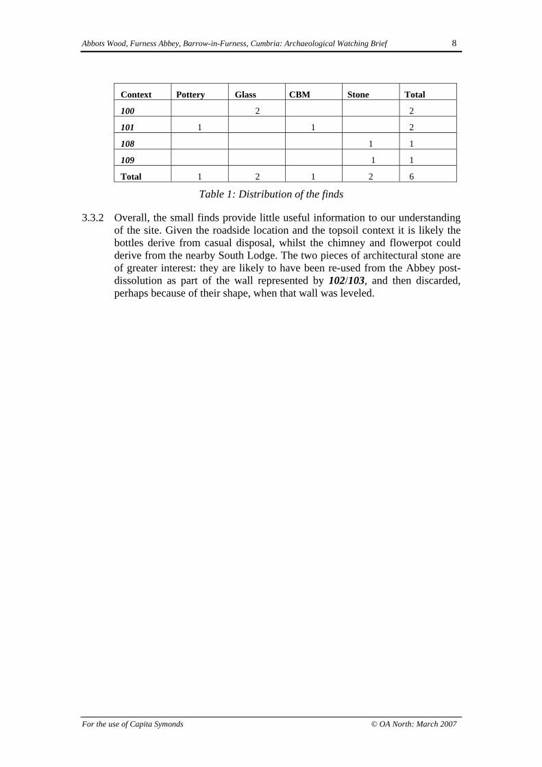
3.3.1 In total, six objects were recovered during the watching brief, all from thetopsoil and subsoil; their distribution is tabulated below. The finds from topsoil100 were both glass bottles from the first half of the twentieth century. Thosefrom subsoil 101 comprised a sherd of flowerpot rim and a fragment of rimfrom a chimney pot dating from the nineteenth or early twentieth century. Thepieces of dressed sandstone, 108 and 109, although never adjoining, appearedto be elements of a fairly small archway, as suggested by their fairly steepcurvature. Both pieces bore clear tooling marks, had a square-moulded margin,and 109 appeared to have a possible mason’s mark
Abbots Wood, Furness Abbey, Barrow-in-Furness, Cumbria: Archaeological Watching Brief 8
For the use of Capita Symonds © OA North: March 2007
Context Pottery Glass CBM Stone Total
100 2 2
101 1 1 2
108 1 1
109 1 1
Total 1 2 1 2 6
Table 1: Distribution of the finds
3.3.2 Overall, the small finds provide little useful information to our understandingof the site. Given the roadside location and the topsoil context it is likely thebottles derive from casual disposal, whilst the chimney and flowerpot couldderive from the nearby South Lodge. The two pieces of architectural stone areof greater interest: they are likely to have been re-used from the Abbey post-dissolution as part of the wall represented by 102/103, and then discarded,perhaps because of their shape, when that wall was leveled.
Abbots Wood, Furness Abbey, Barrow-in-Furness, Cumbria: Archaeological Watching Brief 9
For the use of Capita Symonds © OA North: March 2007
4. DISCUSSION
4.1 CONCLUSION
4.1.1 Although post-medieval archaeological features were found during thewatching brief in the form of sandstone wall 102/103, the significance of theseremains is hard to judge, given the lack of any closely-associated datingevidence. The individual blocks of this wall are quite large and, like looseblocks 108 and 109, are likely to have derived from the Abbey after it wasdissolved. However, the fact that the wall was only a single block thick and ofdrystone construction, would suggest that it was originally neither particularlytall nor substantial, but was likely to have continued to the north-east, in thedirection of South Lodge, and perhaps to the south-west, where it has sincebeen truncated by the modern route of Manor Road. It is possible that the wallrepresents a boundary between Abbotts Wood and the grounds of South Lodgethat extended into the formerly-wooded area: the thick subsoil horizon acrossthis area would certainly suggest that the area had formerly been wooded atleast up to the line of what is now Manor Road.
4.2 ASSESSMENT OF IMPACT
4.2.1 The present scheme of construction has had a limited impact on thearchaeological resource, although it has been able to identify the potential forsurvival of further buried archaeological remains within the vicinity. However,the fact that the thick subsoil horizon would suggest that the area had formerlybeen quite heavily wooded, most likely as part of Abbotts Wood itself, maysuggest that all but the deepest negative archaeological features are likely tohave been greatly reduced through bioturbation.
Abbots Wood, Furness Abbey, Barrow-in-Furness, Cumbria: Archaeological Watching Brief 10
For the use of Capita Symonds © OA North: March 2007
5. REFERENCES
5.1 SECONDARY SOURCES
Baines, E, 1824 A History of the Counties of Lancashire and Cumberland, 1, London
Countryside Commission, 1998 Countryside Character, Volume 2: North West,Cheltenham
Dickinson, J C, 1965 Furness Abbey, London
English Heritage, 1991 Management of Archaeological Projects, 2nd edn, London
English Heritage, 2003 Archaeological Assessment and Strategy Reports – BarrowDistrict
Faull, ML, and Stinson, M (eds), 1986 Yorkshire, in J Morris (ed), Domesday Book,30, Chichester
Hodgkinson, D (ed), 2000 The Lowland Wetlands of Cumbria, North West WetlandsSurvey, 6, Lancaster
Ordnance Survey 1983, Soil Survey of England and Wales, 1983 Soils of NorthernEngland, Sheet 1, 1:250000
Pevsner, N, 1967 Buildings of England: Cumberland and Westmorland, London
Abbots Wood, Furness Abbey, Barrow-in-Furness, Cumbria: Archaeological Watching Brief 11
For the use of Capita Symonds © OA North: March 2007
6. ILLUSTRATIONS
8.1 FIGURES
Figure 1: Location map
Figure 2: Plan of carpark watching brief area
8.2 PLATES
Plate 1: General shot of the area on the north side of the boundary wall
Plate 2: South-facing section for proposed wall foundation
Plate 3: South-west end of sandstone wall 102
Plate 4: North-east end of sandstone wall, 103
Plate 5: Dressed stone 108 and 109, found adjacent to 103
Plate 6: East-facing section of soakaway
Plate 7: General shot of path after old surface removed


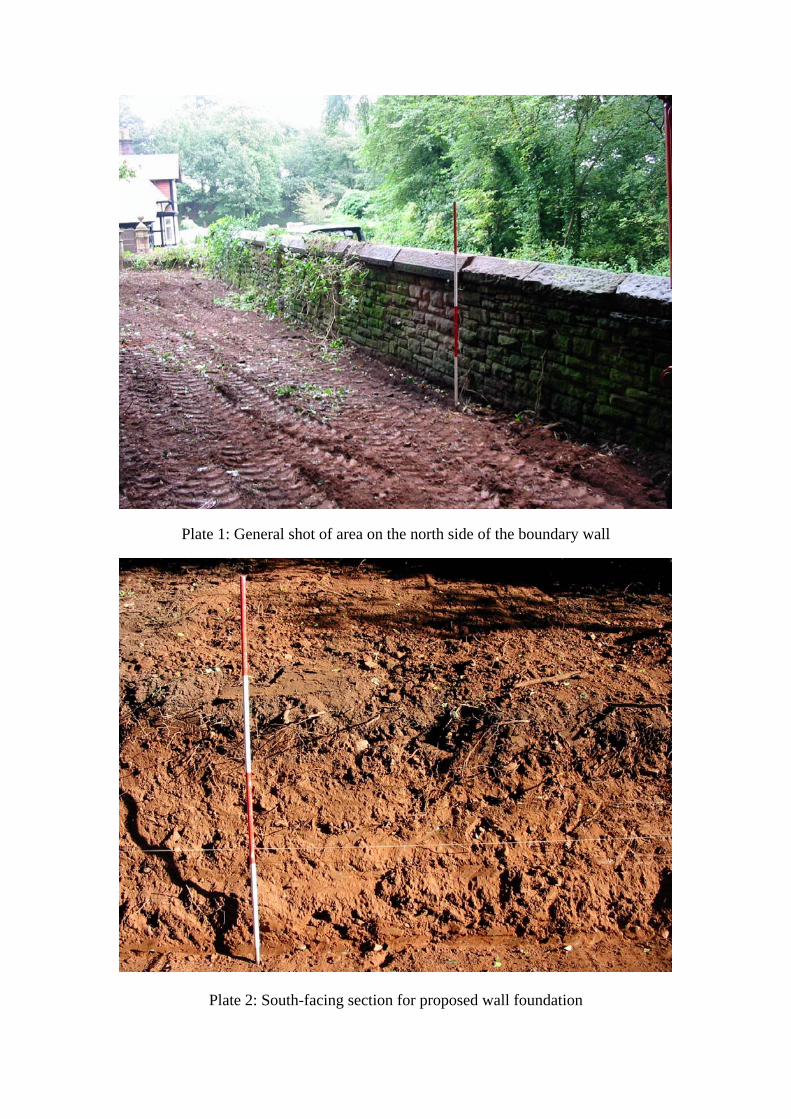
Plate 1: General shot of area on the north side of the boundary wall
Plate 2: South-facing section for proposed wall foundation

Plate 3: General shot of Sandstone wall 102
Plate 4: North-east end of sandstone wall 103

Plate 5: Dressed stone 108 and 109, found adjacent to wall 103
Plate 6: East-facing section of soakaway

Plate 7: General shot of path after old surface removed
Abbots Wood, Furness Abbey, Barrow-in-Furness, Cumbria: Archaeological Watching Brief 12
For the use of Capita Symonds © OA North: March 2007
APPENDIX 1: PROJECT DESIGN
PROPOSEDCARPARKCONSTRUCTIONAND FOOTPATHRESURFACING,ABBOTT’SWOOD, FURNESSABBEY,BARROW-IN-FURNESS,CUMBRIA
Watching Brief DraftProject Design
Oxford Archaeology North
May 2006
Capita Symonds
OA North Tender No: t2758NGR: SD 219 720Planning Application No: 6/06/9004

Abbots Wood, Furness Abbey, Barrow-in-Furness, Cumbria: Archaeological Watching Brief 13
For the use of Capita Symonds © OA North: March 2007
1 INTRODUCTION
1.1 PROJECT BACKGROUND
1.1.1 Capita Symonds (hereafter ‘the Client’), has requested that Oxford Archaeology North (OANorth) submit proposals for a watching brief to be undertaken during, groundworks associatedwith a programme of development within Abbott’s Wood, Furness Abbey, Barrow-in-Furness,Cumbria (Grid reference SD 219 720; Planning Reference 6/06/9004). The development lieswithin the Furness Abbey Scheduled Monument, and therefore, English Heritage (EH)requested that all ground disturbing activities associated with the development should be thesubject of a programme of archaeological monitoring. The current scheme comprises twoparts; firstly, it is proposed that a small carpark will be built off Manor Road, close to theSouth Lodge; secondly, existing footpaths within Abbott’s Wood will be repaired. Theconstruction of the carpark will involved the removal of an existing wall and its reconstructionwithin newly-excavated footings. Across the area of the carpark, the existing ground surfacewill be reduced by 400mm. The upgrading of the footpaths will involve the removal of 50mm-100mm of material from the existing footpath surfaces before these are then built-up with newmaterials. The following document represents a project design to carry out a scheme ofarchaeological monitoring on the above programme of groundworks.
1.2 HISTORICAL AND ARCHAEOLOGICAL BACKGROUND
1.2.1 Although separated from the main Abbey complex to the west by the Barrow to Daltonrailway line, the proposed development site lies within the 30ha Furness Abbey ScheduledArea as defined by the extant Park Wall. The Abbey originated as a Savignac house in theearly twelfth century, but, by 1148 the community had been forcibly absorbed by theCistercians, eventually becoming the most influential religious house in the north-west and thesecond richest in England (Coppack 1998). Between 1150 and 1500, various elements of thecomplex were either rebuilt or newly-constructed, before, in 1537, the abbey was dissolvedand partially demolished (ibid). Although the proposed development appears not to affect anyknown surviving structures, it is possible that groundworks associated with the developmentwill encounter the buried remains of ancillary structures or features. Also of interest on theeastern side of the side and transected by the modern railway line, are a series of earthworksthought to be associated with management of the abbey’s water supply (ibid).
1.3 OXFORD ARCHAEOLOGY NORTH
1.3.1 OA North has considerable experience of excavation of sites of all periods, having undertakena great number of small and large scale projects throughout Northern England during the past25 years. Evaluations, desk-based assessments, watching briefs and excavations have takenplace within the planning process, to fulfil the requirements of clients and planningauthorities, to very rigorous timetables. OA North has the professional expertise and resourcesto undertake the project detailed below to a high level of quality and efficiency. OA North isan Institute of Field Archaeologists (IFA) registered organisation, registration number17, and all its members of staff operate subject to the IFA Code of Conduct.
2 OBJECTIVES
2.1 The following programme has been designed to record the archaeological deposits affected bythe proposed development of the site, in order to determine their extent, nature andsignificance. The required stages to achieve these ends are as follows:
2.2 Archaeological Watching Brief: to undertake a programme of observation and recordingduring any ground disturbance to determine the presence, quality, extent and importance ofany archaeological remains on the site.
2.3 Report and Archive: a report will be produced for the Client within eight weeks of completionof the fieldwork. A site archive will be produced to English Heritage guidelines (1991) and in

Abbots Wood, Furness Abbey, Barrow-in-Furness, Cumbria: Archaeological Watching Brief 14
For the use of Capita Symonds © OA North: March 2007
accordance with the Guidelines for the Preparation of Excavation Archives for Long TermStorage (UKIC 1990).
3 METHOD STATEMENT
3.1 WATCHING BRIEF
3.1.1 Methodology: a programme of field observation will accurately record the location, extent,and character of any surviving archaeological features and/or deposits within the whole area ofthe proposed ground disturbance. This work will comprise observation during all groundreduction and excavations for the proposed development, the systematic examination of anysubsoil horizons exposed during the course of the groundworks, and the accurate recording ofall archaeological features and horizons, and any artefacts, identified during observation.
3.1.2 The watching brief will cover the whole of the area to be disturbed by the developmentincluding, topsoil and subsoil stripping, the removal of any peat deposits and any othergroundworks which would expose the natural drift geology.
3.1.3 Putative archaeological features and/or deposits identified during the observation ofgroundworks, together with the immediate vicinity of any such features, will be cleaned byhand, using either hoes, shovel scraping, and/or trowels depending on the subsoil conditionsand, where appropriate, sections will be studied and drawn. Any such features will be sampleexcavated (ie. selected pits and postholes will normally only be half-sectioned, linear featureswill be subject to no more than a 10% sample, and extensive layers will, where possible, besampled by partial rather than complete removal).
3.1.4 During this phase of work, recording will comprise a full description and preliminaryclassification of features or materials revealed, and their accurate location (either on planand/or section, and as grid co-ordinates where appropriate). Features will be plannedaccurately at appropriate scales and annotated on to a large-scale plan provided by the Client.A photographic record will be undertaken simultaneously.
3.1.5 A plan will be produced of the areas of groundworks showing the location and extent of theground disturbance and one or more dimensioned sections will be produced.
3.1.6 Treatment of finds: all finds will be exposed, lifted, cleaned, conserved, marked, bagged andboxed in accordance with the United Kingdom Institute for Conservation (UKIC) First AidFor Finds, 1998 (new edition) and the recipient museum's guidelines.
3.1.7 Treasure: any gold and silver artefacts recovered during the course of the excavation will beremoved to a safe place and reported to the local Coroner according to the procedures relatingto the Treasure Act, 1996. Where removal cannot take place on the same working day asdiscovery, suitable security will be employed to protect the finds from theft.
3.1.8 All identified finds and artefacts will be retained, although certain classes of building materialcan sometimes be discarded after recording if an appropriate sample is retained on advicefrom the recipient museum’s archive curator.
3.1.9 Human Remains: any human remains uncovered will be left in situ, covered and protected.No further investigation will continue beyond that required to establish the date and characterof the burial. EH and the local Coroner will be informed immediately. If removal is essential,the exhumation of any funerary remains will require the provision of a Home Office license,under section 25 of the Burial Act of 1857. Because of the proximity of the development siteto the extension of the Friend’s Burial Ground on Sedbergh Road, an application will be madeby OA North for the study area prior to the commencement of groundworks within thesouthern area of the site. The removal of human remains will be carried out with due care andsensitivity under the environmental health regulations.

Abbots Wood, Furness Abbey, Barrow-in-Furness, Cumbria: Archaeological Watching Brief 15
For the use of Capita Symonds © OA North: March 2007
3.1.10 Contingency plan: in the event of significant archaeological features being encounteredduring the watching brief, discussions will take place with the Planning Archaeologist or hisrepresentative, as to the extent of further works to be carried out. All further works would besubject to a variation to this project design. In the event of environmental/organic depositsbeing present on site, it would be necessary to discuss and agree a programme ofpalaeoenvironmental sampling and or dating with the Planning Archaeologist.
3.2 REPORT AND ARCHIVE
3.2.1 Report: one bound and one unbound copy of a written synthetic report will be submitted to theClient, one copy to the EH Archaeologist, and a further three copies submitted to the CumbriaHER within eight weeks of completion. The report will include:
• a front cover to include the planning application number and the NGR
• a site location plan, related to the national grid
• the dates on which the fieldwork was undertaken
• a concise, non-technical summary of the results
• a description of the methodology employed, work undertaken and results obtained
• plans and sections at an appropriate scale, showing the location of features
• other illustrations and photographic plates showing, as appropriate, features of interest orto demonstrate the absence of archaeological features.
• a description of any environmental, finds, or other specialist work undertaken, and theresults obtained
• the report will also include a complete bibliography of sources from which data has beenderived.
• a copy of this project design in the appendices, and indications of any agreed departurefrom that design
3.2.2 This report will be in the same basic format as this project design; a copy of the report can beprovided on CD, if required.
3.2.3 Archive: the results of all archaeological work carried out will form the basis for a full archiveto professional standards, in accordance with current English Heritage guidelines(Management of Archaeological Projects, 2nd edition, 1991). The project archive representsthe collation and indexing of all the data and material gathered during the course of theproject. It will include summary processing and analysis of all features, finds, orpalaeoenvironmental data recovered during fieldwork, which will be catalogued by context.All artefacts will be processed to MAP2 standards and will be assessed by our in-house findsspecialists.
3.2.4 The deposition of a properly ordered and indexed project archive in an appropriate repositoryis considered an essential and integral element of all archaeological projects by the IFA in thatorganisation's code of conduct. OA North conforms to best practice in the preparation ofproject archives for long-term storage. This archive will be provided in the English HeritageCentre for Archaeology format and a synthesis will be submitted to the Cumbria HER (theindex to the archive and a copy of the report). OA North practice is to deposit the originalrecord archive of projects with the County Record Office, Kendal. The material archive(artefacts and ecofacts) will be deposited with an appropriate museum following agreementwith the client.

Abbots Wood, Furness Abbey, Barrow-in-Furness, Cumbria: Archaeological Watching Brief 16
For the use of Capita Symonds © OA North: March 2007
3.2.5 Collation of data: the data generated will be collated and analysed in order to provide anassessment of the nature and significance of the known surface and subsurface remains withinthe designated area. It will also serve as a guide to the archaeological potential of the area tobe investigated, and the basis for the formulation of any detailed field programme andassociated sampling strategy, should these be required in the future.
3.2.6 The Arts and Humanities Data Service (AHDS) online database project Online Access toindex of Archaeological Investigations (OASIS) will be completed as part of the archivingphase of the project.
3.2.7 Confidentiality: all internal reports to the client are designed as documents for the specific useof the client, for the particular purpose as defined in the project brief and project design, andshould be treated as such. They are not suitable for publication as academic documents orotherwise without amendment or revision. Any requirement to revise or reorder the materialfor submission or presentation to third parties beyond the project brief and project design, orfor any other explicit purpose, can be fulfilled, but will require separate discussion andfunding.
4. HEALTH AND SAFETY
4.1 OA North provides a Health and Safety Statement for all projects and maintains a Unit Safetypolicy. All site procedures are in accordance with the guidance set out in the Health and SafetyManual compiled by the Standing Conference of Archaeological Unit Managers (1997). Arisk assessment will be completed in advance of any on-site works and copies will be madeavailable on request to all interested parties.
5. WORK TIMETABLE
5.1 Archaeological Watching Brief: the duration of this element is dependant upon the durationof any ground disturbing activities on the site.
5.2 Report and Archive: a report will be submitted within eight weeks of the completion of thefieldwork. However, should an interim statement be required this can be issued within twoweeks but instruction must be received from the client prior to completion of the fieldwork.
5.3 Written Instruction; OA North can execute projects at very short notice once writtenconfirmation of commission has been received from the Client. One weeks notice would besufficient to allow the necessary arrangements to be made to commence the task and informEH.
6 PROJECT MONITORING
6.1 Access: liaison for site access during the evaluation will be arranged with the client unlessotherwise instructed prior to commencement of the archaeological investigation.
6.2 Whilst the work is undertaken for the client, the County Archaeologist will be kept fullyinformed of the work and its results, and will be notified a week in advance of thecommencement of the fieldwork. Any proposed changes to the project design will be agreedwith EH in consultation with the Client.
7. STAFFING PROPOSALS
7.1 The project will be under the direct management of Stephen Rowland (OA North projectmanager) to whom all correspondence should be addressed.
7.2 All elements of the archaeological investigation will be supervised by either an OA Northproject officer or supervisor experienced in this type of project. Due to schedulingrequirements it is not possible to provide these details at the present time. All OA North
Abbots Wood, Furness Abbey, Barrow-in-Furness, Cumbria: Archaeological Watching Brief 17
For the use of Capita Symonds © OA North: March 2007
project officers and supervisors are experienced field archaeologists capable of carrying outprojects of all sizes.
7.3 Assessment of the finds from the evaluation will be undertaken under the auspices of OANorth's in-house finds specialist Christine Howard-Davis BA MIFA (OA North projectofficer). Christine has extensive knowledge of all finds of all periods from archaeological sitesin northern England. However, she has specialist knowledge regarding glass, metalwork, andleather, the recording and management of waterlogged wood, and most aspects of wetland andenvironmental archaeology.
7.4 Assessment of any palaeoenvironmental samples which may be taken will be undertaken byElizabeth Huckerby MSc (OA North project officer). Elizabeth has extensive knowledge ofthe palaeoecology of the North West through her work on the English Heritage-funded NorthWest Wetlands Survey. Assessment of any faunal material will be undertaken by AndrewBates MSc (OA North Supervisor).
8. BIBLIOGRAPHY
Coppack, G, 1998 ‘Furness Abbey,’ in D Robinson (ed) The Cistercian Abbeys of Britain(Batsford - London)
Institute of Field Archaeologists (IFA), 1992, Guidelines for data collection and compilation
SCAUM (Standing Conference of Archaeological Unit Managers), 1997, Health and SafetyManual, Poole
United Kingdom Institute for Conservation (UKIC), 1990, Guidelines for the preparation ofarchives for long-term storage, London
United Kingdom Institute for Conservation (UKIC), 1998, First Aid for Finds, London

Abbots Wood, Furness Abbey, Barrow-in-Furness, Cumbria: Archaeological Watching Brief 18
For the use of Capita Symonds © OA North: March 2007
APPENDIX 2: SUMMARY OF CONTEXTS
Context Type Dimensions Description
100 Topsoil 0.3m in depth Friable reddish-brown slightly sandy clay
101 Subsoil 1.1m in depth Firm reddish-brown slightly sandy clay, 20%inclusions of small sub-rounded and sub-angular stones
102 Wall 4.35m long0.3m wide,0.2m in depth
Base of drystone wall, consisting of rough cut anduncut stone, up to 0.4m x 0.3m in size, fairly uniform.0.05m to 0.2m in depth.
103 Wall 2.05m long0.25m wide, 0.1in depth
Base of drystone wall, consisting of rough cut anduncut stone, up to 0.4m x 0.3m in size, fairly uniform.0.05m to 0.1m in depth.
104 Surface 0.05m in depth Tar Macadam
105 Layer 0.1m in depth Fine pinkish-brown compacted limestone chippings
106 0.4m in depth Compacted reddish-mauve small to medium limestonechippings and sub-rounded stone
107 Natural 0.95m+ in depth Compact reddish-brown sandy clay with 30%inclusions of small to medium sub-rounded and sub-angular sandstone.
108 DressedStone
0.27m by 0.26mat base, 0.33mhigh
Dressed St Bees sandstone block with approximatelysquare base. Two sides slope-in to give dimensions of0.22m by 0.22m at the top, which is slightly convex.One side is chamfered (0.04m)
109 DressedStone
0.26m by 0.25mat base, 0.22mhigh
Dressed St Bees sandstone block with approximatelysquare base. Two sides slope-in to give dimensions of0.21m by 0.19m at the top, which is slightly convex.One side is chamfered (0.04m)