
A9.1 - Surface Water Hydrology Report - Transport … · Alterations to surface water hydrology...
39
A9.1 - Surface Water Hydrology Report 0010332 December 2006 Jacobs UK 95 Bothwell Street, Glasgow G2 7HX Tel 0141 204 2511 Fax 0141 226 3109 Copyright Jacobs UK Limited. All rights reserved. No part of this report may be copied or reproduced by any means without prior written permission from Jacobs UK Limited. If you have received this report in error, please destroy all copies in your possession or control and notify Jacobs UK Limited. This report has been prepared for the exclusive use of the commissioning party and unless otherwise agreed in writing by Jacobs UK Limited, no other party may use, make use of or rely on the contents of this report. No liability is accepted by Jacobs UK Limited for any use of this report, other than for the purposes for which it was originally prepared and provided. Opinions and information provided in the report are on the basis of Jacobs UK Limited using due skill, care and diligence in the preparation of the same and no explicit warranty is provided as to their accuracy. It should be noted and it is expressly stated that no independent verification of any of the documents or information supplied to Jacobs UK Limited has been made.
Transcript of A9.1 - Surface Water Hydrology Report - Transport … · Alterations to surface water hydrology...
A9.1 - Surface Water Hydrology Report
0010332 December 2006 Jacobs UK 95 Bothwell Street, Glasgow G2 7HX Tel 0141 204 2511 Fax 0141 226 3109
Copyright Jacobs UK Limited. All rights reserved.
No part of this report may be copied or reproduced by any means without prior written permission from Jacobs UK Limited. If you have received this report in error, please destroy all copies in your possession or control and notify Jacobs UK Limited.
This report has been prepared for the exclusive use of the commissioning party and unless otherwise agreed in writing by Jacobs UK Limited, no other party may use, make use of or rely on the contents of this report. No liability is accepted by Jacobs UK Limited for any use of this report, other than for the purposes for which it was originally prepared and provided.
Opinions and information provided in the report are on the basis of Jacobs UK Limited using due skill, care and diligence in the preparation of the same and no explicit warranty is provided as to their accuracy.
It should be noted and it is expressly stated that no independent verification of any of the documents or information supplied to Jacobs UK Limited has been made.

Aberdeen Western Peripheral Route Environmental Statement Appendices Part B: Northern Leg Appendix A9.1 - Surface Water Hydrology
A9.1-1
Contents
1 Introduction .......................................................................................................................2 1.1 General Background ...........................................................................................................2 1.2 The Proposed Scheme .......................................................................................................2 1.3 Assessment Aims................................................................................................................2 2 Approach and Methods ....................................................................................................3 2.1 General Approach ...............................................................................................................3 2.2 Assessment Methodology...................................................................................................5 2.3 Limitations to Assessment ..................................................................................................9 3 Baseline..............................................................................................................................9 3.1 Introduction .........................................................................................................................9 3.2 Baseline Assessment..........................................................................................................9 3.3 Baseline Road Runoff .......................................................................................................11 3.4 Baseline Summary ............................................................................................................11 4 Potential Impacts ............................................................................................................14 4.1 Introduction .......................................................................................................................14 4.2 Operation Impacts.............................................................................................................14 4.3 Construction Impacts ........................................................................................................19 4.4 Scheme Summary.............................................................................................................23 5 Mitigation and Recommendations ................................................................................24 5.1 Mitigation...........................................................................................................................24 5.2 Operation Mitigation and Recommendations....................................................................26 5.3 Construction Mitigation and Recommendations ...............................................................27 6 Residual Impacts.............................................................................................................29 6.1 Operation Residual Impacts..............................................................................................29 6.2 Construction Residual Impacts .........................................................................................29 6.3 Scheme Summary.............................................................................................................29 7 References.......................................................................................................................36 8 Glossary...........................................................................................................................37
Aberdeen Western Peripheral Route Environmental Statement Appendices Part B: Northern Leg Appendix A9.1 - Surface Water Hydrology
A9.1-2
1 Introduction
1.1 General Background
1.1.1 This hydrological assessment report is a technical appendix of Chapter 9 (Water Environment) of the Environmental Statement for the proposed Aberdeen Western Peripheral Route (AWPR). It focuses specifically on the hydrological impacts of the Northern Leg of the proposed scheme on watercourses crossed by the road during both the construction and operation phase.
1.1.2 Hydrology is concerned with the natural water cycle and is the earth science of water on or near the land surface. For the purposes of this report, the hydrological assessment addresses impacts on the flow and quantity of water on or near the land surface and associated flood risk. Impacts upon hydrology are intrinsically linked to hydrogeology, water quality, geomorphology and ecology.
1.1.3 Potentially, road schemes can impact on surface water hydrology through the addition of structures and by disturbing the natural characteristics of a watercourse and its catchment. Watercourses may be affected, for example, by direct runoff from the road itself. As a result the natural magnitude, direction and timing of surface water events can become significantly altered (see Section 4). Alterations to surface water hydrology could potentially have profound implications for the local ecology, society and economy, as has been recognised by the EU Water Framework Directive and the Risk Framework of Scottish Planning Policy Guidance 7 (SPP7).
1.1.4 This hydrological appraisal focuses on the River Don and approximately 14 other watercourses which are likely to be subject to impacts as a result of the operation and construction of the road. These watercourses range in size, from small ephemeral field drains to large streams.
1.2 The Proposed Scheme
1.2.1 Jacobs has been commissioned by the Aberdeen Western Peripheral Route (AWPR) Managing Agent to undertake a Stage 3 Environmental Impact Assessment (EIA) of a proposed road scheme near Aberdeen, Scotland. The scheme comprises an approximately 30 km peripheral route around the City of Aberdeen, starting at the A90/A956 Charlestown Junction and finishing at the A90 Blackdog Junction and additional 15km Fastlink between Stonehaven and the new peripheral route. The entire scheme is divided into three sections:
• Northern Leg including the main line from Kingswells to the A90 Blackdog Junction (chainage 314800-330750);
• South Leg comprising of Burnhead to North Kingswell main line (chainage 100000 - 111400-214900); and, the Burnhead to Charleston main line (chainage 200000 – 207270).
• Stonehaven Fastlink connecting Stonehaven with the AWPR Southern Leg (chainage 0-11498).
1.2.2 The Northern Leg comprises an approximately 15km route from Kingswells in the south and west of the City of Aberdeen to Blackdog in the north. Further information about the road scheme is contained in Chapter 4 (The Proposed Scheme).
1.3 Assessment Aims
1.3.1 This report assesses the environmental impact of the proposed AWPR on surface water hydrology. The system of assessment followed the basic methodology detailed below:
Aberdeen Western Peripheral Route Environmental Statement Appendices Part B: Northern Leg Appendix A9.1 - Surface Water Hydrology
A9.1-3
• assess the present baseline condition;
• assess the potential impacts to the baseline condition if the road were to go ahead;
• suggest mitigation measures for the potential impacts; and
• assess the residual impacts following adoption of the suggested mitigation measures.
2 Approach and Methods
2.1 General Approach
2.1.1 This report concentrates on outlining the potential effects of the road scheme on the surface water hydrology of the watercourses crossed by the proposed road.
2.1.2 The system of assessment followed the basic methodology detailed below:
• describe the present baseline condition;
• assess the potential impacts to the baseline condition from the proposed road;
• suggest mitigation measures for the potential impacts; and,
• assess the residual impacts following adoption of the suggested measures.
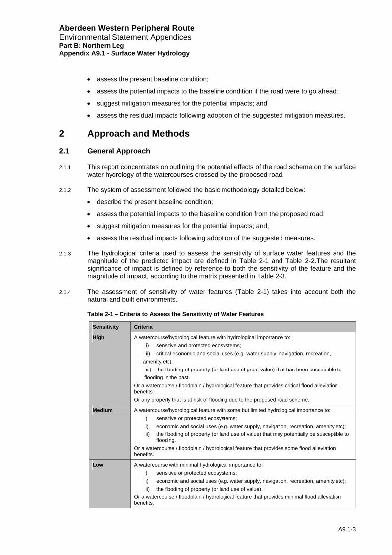
2.1.3 The hydrological criteria used to assess the sensitivity of surface water features and the magnitude of the predicted impact are defined in Table 2-1 and Table 2-2.The resultant significance of impact is defined by reference to both the sensitivity of the feature and the magnitude of impact, according to the matrix presented in Table 2-3.
2.1.4 The assessment of sensitivity of water features (Table 2-1) takes into account both the natural and built environments.
Table 2-1 – Criteria to Assess the Sensitivity of Water Features
Sensitivity Criteria
High A watercourse/hydrological feature with hydrological importance to: i) sensitive and protected ecosystems; ii) critical economic and social uses (e.g. water supply, navigation, recreation,
amenity etc); iii) the flooding of property (or land use of great value) that has been susceptible to
flooding in the past. Or a watercourse / floodplain / hydrological feature that provides critical flood alleviation benefits. Or any property that is at risk of flooding due to the proposed road scheme.
Medium A watercourse/hydrological feature with some but limited hydrological importance to: i) sensitive or protected ecosystems; ii) economic and social uses (e.g. water supply, navigation, recreation, amenity etc); iii) the flooding of property (or land use of value) that may potentially be susceptible to
flooding. Or a watercourse / floodplain / hydrological feature that provides some flood alleviation benefits.
Low A watercourse with minimal hydrological importance to: i) sensitive or protected ecosystems; ii) economic and social uses (e.g. water supply, navigation, recreation, amenity etc); iii) the flooding of property (or land use of value).
Or a watercourse / floodplain / hydrological feature that provides minimal flood alleviation benefits.
Aberdeen Western Peripheral Route Environmental Statement Appendices Part B: Northern Leg Appendix A9.1 - Surface Water Hydrology
A9.1-4
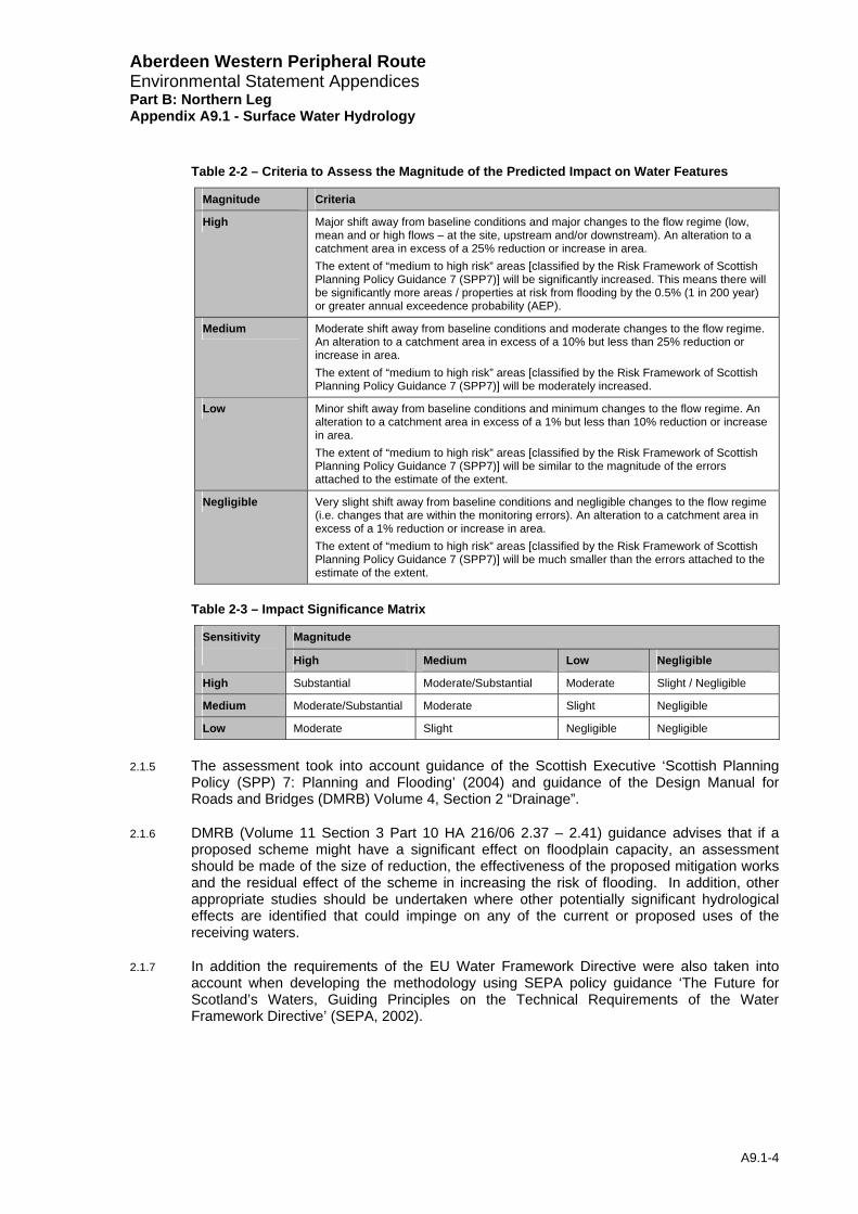
Table 2-2 – Criteria to Assess the Magnitude of the Predicted Impact on Water Features
Magnitude Criteria
High Major shift away from baseline conditions and major changes to the flow regime (low, mean and or high flows – at the site, upstream and/or downstream). An alteration to a catchment area in excess of a 25% reduction or increase in area. The extent of “medium to high risk” areas [classified by the Risk Framework of Scottish Planning Policy Guidance 7 (SPP7)] will be significantly increased. This means there will be significantly more areas / properties at risk from flooding by the 0.5% (1 in 200 year) or greater annual exceedence probability (AEP).
Medium Moderate shift away from baseline conditions and moderate changes to the flow regime. An alteration to a catchment area in excess of a 10% but less than 25% reduction or increase in area. The extent of “medium to high risk” areas [classified by the Risk Framework of Scottish Planning Policy Guidance 7 (SPP7)] will be moderately increased.
Low Minor shift away from baseline conditions and minimum changes to the flow regime. An alteration to a catchment area in excess of a 1% but less than 10% reduction or increase in area. The extent of “medium to high risk” areas [classified by the Risk Framework of Scottish Planning Policy Guidance 7 (SPP7)] will be similar to the magnitude of the errors attached to the estimate of the extent.
Negligible Very slight shift away from baseline conditions and negligible changes to the flow regime (i.e. changes that are within the monitoring errors). An alteration to a catchment area in excess of a 1% reduction or increase in area. The extent of “medium to high risk” areas [classified by the Risk Framework of Scottish Planning Policy Guidance 7 (SPP7)] will be much smaller than the errors attached to the estimate of the extent.
Table 2-3 – Impact Significance Matrix
Magnitude Sensitivity High Medium Low Negligible
High Substantial Moderate/Substantial Moderate Slight / Negligible
Medium Moderate/Substantial Moderate Slight Negligible
Low Moderate Slight Negligible Negligible
2.1.5 The assessment took into account guidance of the Scottish Executive ‘Scottish Planning Policy (SPP) 7: Planning and Flooding’ (2004) and guidance of the Design Manual for Roads and Bridges (DMRB) Volume 4, Section 2 “Drainage”.
2.1.6 DMRB (Volume 11 Section 3 Part 10 HA 216/06 2.37 – 2.41) guidance advises that if a proposed scheme might have a significant effect on floodplain capacity, an assessment should be made of the size of reduction, the effectiveness of the proposed mitigation works and the residual effect of the scheme in increasing the risk of flooding. In addition, other appropriate studies should be undertaken where other potentially significant hydrological effects are identified that could impinge on any of the current or proposed uses of the receiving waters.
2.1.7 In addition the requirements of the EU Water Framework Directive were also taken into account when developing the methodology using SEPA policy guidance ‘The Future for Scotland’s Waters, Guiding Principles on the Technical Requirements of the Water Framework Directive’ (SEPA, 2002).
Aberdeen Western Peripheral Route Environmental Statement Appendices Part B: Northern Leg Appendix A9.1 - Surface Water Hydrology
A9.1-5
2.2 Assessment Methodology
Baseline Assessment
2.2.1 In Scotland, local authorities are responsible for watercourses and flooding matters. Aberdeen City and Aberdeenshire Councils were contacted to obtain baseline information including information on economic and recreational uses of the watercourses, existing and historic flood risk and relevant flood studies. Similarly, SEPA were also contacted with regards to their understanding of the flood risk posed by the various watercourses as well as flow and watercourse information. The ‘Hydrological Data United Kingdom: Hydrometric Register and Statistics 1996-2000’ (Centre for Hydrology and Ecology, 2003), SEPA, and the HiFlows-UK website were consulted to give information on gauged catchments.
2.2.2 For each identified watercourse the following estimates have been calculated for the present conditions;
• 95-percentile flow (Q95);
• mean flow;
• bankfull and embankmentfull flow;
• median annual maximum flood (QMED);
• mean annual maximum flood (QBAR); and
• flood design peak flows including the 1% and 0.5% annual exceedance probability (AEP) flows (also known as the 100-year and 200-year flood design peak flows).
2.2.3 Necessary hydrological catchment characteristics were obtained from Ordnance Survey, soils, geological and land use maps as well as the Flood Estimation Handbook (FEH) CD-ROM.
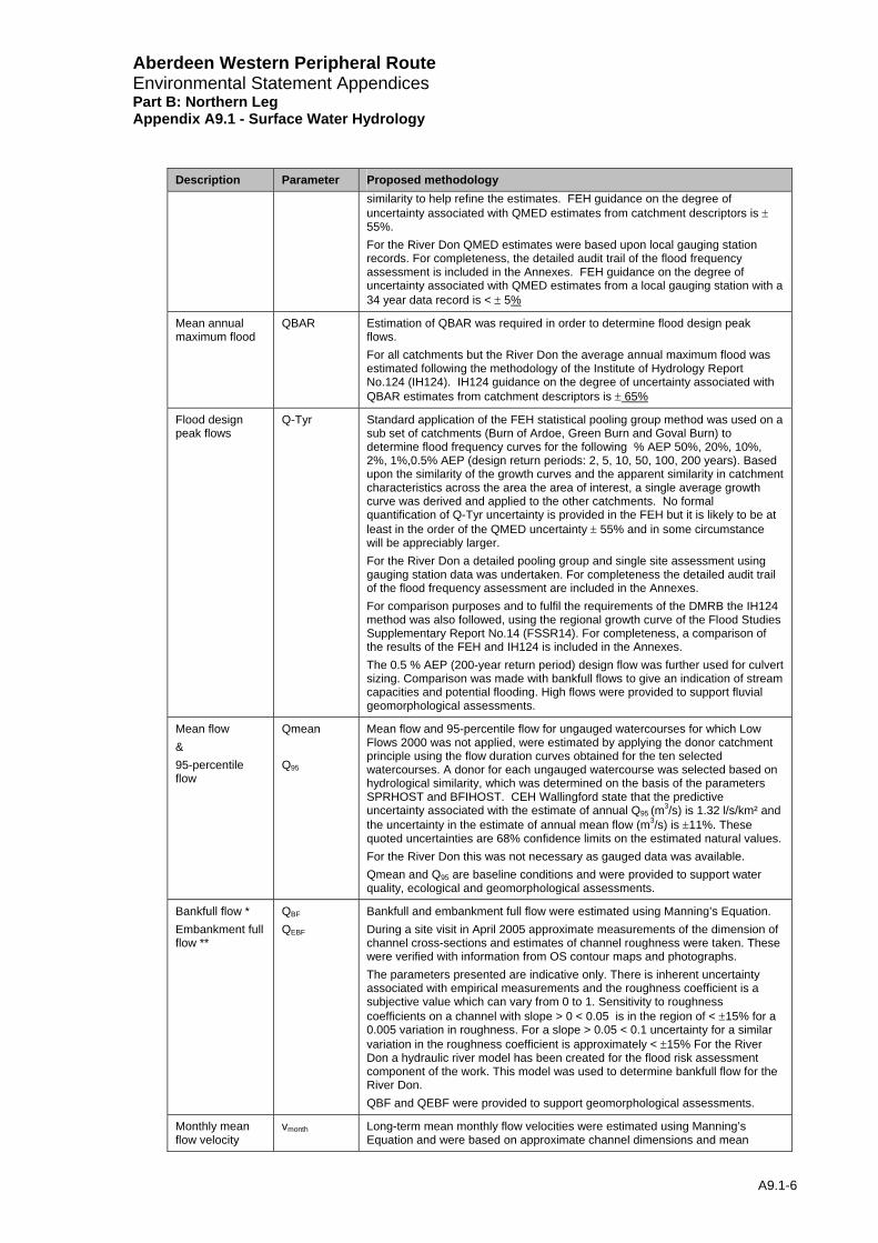
2.2.4 Table 2-4 identifies the flow parameters and methodologies that were used. It is noted that, apart from the Rivers Dee and Don, all watercourses to be crossed by the complete AWPR are small, ungauged catchments. Flow estimation on ungauged watercourses is generally subject to significant uncertainties. In order to increase the confidence in the standard desk based flow estimates, site measurements were recommended. Thus, site measurements aimed at refining several of hydrological parameters were undertaken during April 2005 at representative catchments. Desk-based procedures, gauged data from donor/analogue catchments1 and where appropriate from actual spot gauging of a watercourse were used, as outlined in Table 2-4.
Table 2-4 Hydrological parameters and methodologies
Description Parameter Proposed methodology
Median annual maximum flood
QMED Estimation of QMED was required in order to determine flood design peak flows. The median annual maximum flood flow was estimated for all watercourses following the guidance of the Flood Estimation Handbook (FEH). The QMED from catchment descriptors at ungauged subject sites was refined by using a regional factor based upon interpretation of general performance of the FEH empirical equations against values obtained from gauged sites on the Rivers Don, Dee and Ythan, that were deemed to have sufficient hydro-climatic
1 The procedure uses data transfer from gauged sites to refine flow estimates at ungauged sites. Donor sites are local catchments situated on the same watercourse as the subject site or a tributary thereof. Analogue sites are more distant gauged catchments that are sufficiently similar to the subject catchment.
Aberdeen Western Peripheral Route Environmental Statement Appendices Part B: Northern Leg Appendix A9.1 - Surface Water Hydrology
A9.1-6
Description Parameter Proposed methodology similarity to help refine the estimates. FEH guidance on the degree of uncertainty associated with QMED estimates from catchment descriptors is ± 55%. For the River Don QMED estimates were based upon local gauging station records. For completeness, the detailed audit trail of the flood frequency assessment is included in the Annexes. FEH guidance on the degree of uncertainty associated with QMED estimates from a local gauging station with a 34 year data record is < ± 5%
Mean annual maximum flood
QBAR Estimation of QBAR was required in order to determine flood design peak flows. For all catchments but the River Don the average annual maximum flood was estimated following the methodology of the Institute of Hydrology Report No.124 (IH124). IH124 guidance on the degree of uncertainty associated with QBAR estimates from catchment descriptors is ± 65%
Flood design peak flows
Q-Tyr Standard application of the FEH statistical pooling group method was used on a sub set of catchments (Burn of Ardoe, Green Burn and Goval Burn) to determine flood frequency curves for the following % AEP 50%, 20%, 10%, 2%, 1%,0.5% AEP (design return periods: 2, 5, 10, 50, 100, 200 years). Based upon the similarity of the growth curves and the apparent similarity in catchment characteristics across the area the area of interest, a single average growth curve was derived and applied to the other catchments. No formal quantification of Q-Tyr uncertainty is provided in the FEH but it is likely to be at least in the order of the QMED uncertainty ± 55% and in some circumstance will be appreciably larger. For the River Don a detailed pooling group and single site assessment using gauging station data was undertaken. For completeness the detailed audit trail of the flood frequency assessment are included in the Annexes. For comparison purposes and to fulfil the requirements of the DMRB the IH124 method was also followed, using the regional growth curve of the Flood Studies Supplementary Report No.14 (FSSR14). For completeness, a comparison of the results of the FEH and IH124 is included in the Annexes. The 0.5 % AEP (200-year return period) design flow was further used for culvert sizing. Comparison was made with bankfull flows to give an indication of stream capacities and potential flooding. High flows were provided to support fluvial geomorphological assessments.
Mean flow & 95-percentile flow
Qmean Q95
Mean flow and 95-percentile flow for ungauged watercourses for which Low Flows 2000 was not applied, were estimated by applying the donor catchment principle using the flow duration curves obtained for the ten selected watercourses. A donor for each ungauged watercourse was selected based on hydrological similarity, which was determined on the basis of the parameters SPRHOST and BFIHOST. CEH Wallingford state that the predictive uncertainty associated with the estimate of annual Q95 (m3/s) is 1.32 l/s/km² and the uncertainty in the estimate of annual mean flow (m3/s) is ±11%. These quoted uncertainties are 68% confidence limits on the estimated natural values. For the River Don this was not necessary as gauged data was available. Qmean and Q95 are baseline conditions and were provided to support water quality, ecological and geomorphological assessments.
Bankfull flow * Embankment full flow **
QBF
QEBF
Bankfull and embankment full flow were estimated using Manning’s Equation. During a site visit in April 2005 approximate measurements of the dimension of channel cross-sections and estimates of channel roughness were taken. These were verified with information from OS contour maps and photographs. The parameters presented are indicative only. There is inherent uncertainty associated with empirical measurements and the roughness coefficient is a subjective value which can vary from 0 to 1. Sensitivity to roughness coefficients on a channel with slope > 0 < 0.05 is in the region of < ±15% for a 0.005 variation in roughness. For a slope > 0.05 < 0.1 uncertainty for a similar variation in the roughness coefficient is approximately < ±15% For the River Don a hydraulic river model has been created for the flood risk assessment component of the work. This model was used to determine bankfull flow for the River Don. QBF and QEBF were provided to support geomorphological assessments.
Monthly mean flow velocity
vmonth Long-term mean monthly flow velocities were estimated using Manning’s Equation and were based on approximate channel dimensions and mean

Aberdeen Western Peripheral Route Environmental Statement Appendices Part B: Northern Leg Appendix A9.1 - Surface Water Hydrology
A9.1-7
Description Parameter Proposed methodology monthly flows from flow duration curves. Mean monthly flows for ungauged watercourses for which Low Flows 2000 was not applied, were estimated by applying the donor principle using the flow duration curves obtained for the ten selected watercourses (see method statement for Qmean and Q95). Uncertainty with this method will incorporate errors associated with the calculation of QBF, QEBF, Q95 and Qmean. An approximate estimation of the uncertainty of these calculations combined would be in the region of ±20 – 25%. For the River Don a hydraulic river model has been created for the flood risk assessment component of the Environmental Statement. This model in combination with the mean monthly was used to determine monthly mean flow velocities. Monthly mean flow velocities were provided to support ecological assessments.
Greenfield runoff rate
q green In order to provide an estimate of Greenfield runoff rates for each of the drainage outfall locations the average of two methodologies was used. SEPA guidance is given in the booklet ‘Guidance for Developers and Regulators Drainage Impact Assessment’ (DP 300 3/02) and states, that in general the 50% AEP (two-year return period) one hour rainfall event should be used to determine the pre-development runoff for the existing site (refer DP300 3/02) (i.e. predevelopment or as a ‘Greenfield site’). According to CIRIA609 common values used for Greenfield runoff rates vary between 5 to 7 l/s/ha. However, care should be taken if applying these values, as they may not be applicable to individual sites, since the runoff rate is dependent on factors that include soil type and site gradient. Thus, to provide more site specific estimates of Greenfield runoff the average of the FEH catchment area method and the Rational Method was applied to the outfall locations on the Northern Leg of the AWPR. The FEH catchment area method uses the 50% AEP (2 year return period / QMED, see above method for calculation of median flood flow) FEH flow estimate at the drainage outfall location divided by the area of the catchment to this point to derive a Greenfield runoff rate in l/s/ha. The Rational Method assumes a 1 hectare (ha) catchment and a 60 minute storm duration. The basic form of this method is the following equation: Peak Flow (l/s) = 2.78 * C * I (mm/hr) * A (ha) Where: C is the coefficient of runoff I is the intensity of rainfall A is the area under consideration Values of C are described as varying from 0.05 to represent flat lawns with sandy soils to a maximum of 0.95 representing almost completely impermeable heavily urbanised areas (Maidment, Table 9.4.1). In this case the value of C was set at 0.2 to represent rural land with heavy soils. The rainfall intensity value, I, is determined by dividing the rain depth (mm) for various return periods by the ‘Time of Concentration’ or storm duration. The rain depth for each return period is determined using the Flood Studies Report (FSR) method. This approach involves obtaining the depth of rainfall with a 20% AEP (5 year return period) from the standard FSR maps (Wilson, 2004, Appendix A) and multiplying this value by the appropriate growth factor for the desired return period (Wilson, 2004, Tables, 2.6 and 2.7). Uncertainty within these methods is likely to be at least in the order of the QMED uncertainty ± 55% and in some circumstance will be appreciably larger.
# The Low Flows 2000 estimates were supplied by CEH Wallingford. Basic input information such as catchment area and boundaries were checked and where necessary refined in line with understanding gained during site visits and mapped information. * Bankful flow = the flow capacity of the watercourse with out any water inundating adjacent ground. ** Embankment full flow = the flow capacity of the watercourse feature including any artificial embankments or berms. It can be thought of as the confined flow that does not spread away from the path of the watercourse corridor.

Aberdeen Western Peripheral Route Environmental Statement Appendices Part B: Northern Leg Appendix A9.1 - Surface Water Hydrology
A9.1-8
2.2.5 Some hydrological features include characteristics that require analysis beyond the methodologies described in Table 2-4. These include: Howemoss Springs and Mill Lade-system. These were assessed via site visits between April 2005 and July 2005 together with supporting information from maps and discussion with other experts from related disciplines.
Allowance for Climate Change in Hydrological Parameters
2.2.6 Guidance on this has been taken from a scoping study regarding climate change and hydrological parameters (SEPA, 2005). SEPA do not define a specific value as an allowance for climate change but suggests that the sensitivity of flows within flood risk analysis could be carried out up to a 20% increase in flows for the East of Scotland. 20% is considered the maximum change and evidence suggests that by 2050 there is more likely to be in increase in the region of 15% in the East of Scotland (Environmental Group Research Report, 2003).
2.2.7 The Scottish Executive (2004) state in the SPP7 Planning and Flooding Report (penultimate paragraph of the executive summary) that the threshold annual probability floods 0.5% (200 year) and 0.1% (1000 year), include an allowance for climate change. The Scottish Executive also indicate that developments should now be designed to the 0.5% annual probability design flood event instead of the 1% annual probability event in an allowance for possible future climate change increases.
2.2.8 In the case of the Aberdeen area this provides a safety margin of approximately 14% increase to design flows. Therefore the 0.5% annual probability design flood event has been adopted. No accepted guidance on the other hydrological parameters listed in Table 2-4 is advocated by SEPA. Research work to date on these parameters indicates no clear regional patterns. No climate change is therefore suggested for these parameters, rather the guidance set out in SPP7, specific for Scotland is followed.
Impact Assessment
2.2.9 Hydrological pressures and impacts arising from the proposed road are highlighted with respect to environmental, economic and social impacts. Potential post-development changes to above parameters (Table 2-4) are highlighted as well as potential changes to flood risk and flood plain inundation.
2.2.10 Additionally a desk based assessment of the potential risk of flooding to properties upstream of culverts on the proposed road scheme was undertaken. The risk assessment was based on the distance, position and height difference, from Ordnance Survey plans and detailed design plans between the culvert and properties upstream from the culvert entrance. A further identification of land use upstream of the entrance as wooded areas may store more potential debris from which culverts could become blocked. This broad-brush assessment was used to identify properties that could potentially be at risk of flooding during extreme events.
2.2.11 Several of the above baseline parameters were provided to other discipline assessments where they formed essential parameters. The other disciplines were: the geomorphology (Appendix A9.3), water quality and (Appendix A9.4) sections of the Environmental Statement. The parameters provided include Qmean, Q95, QBF, QEBF, and Vmonth.
2.2.12 The Water Environment and Freshwater Ecology Teams have entered into ongoing liaison and discussion throughout the assessment process to ensure that the interaction of the physical processes and the habitats, which they support, are sufficiently represented. It should be noted that impacts upon freshwater ecology have not formed part of the assessment within this chapter, rather they are dealt with entirely within the Ecology Chapter to minimise double counting of impacts.

Aberdeen Western Peripheral Route Environmental Statement Appendices Part B: Northern Leg Appendix A9.1 - Surface Water Hydrology
A9.1-9
Mitigation Measures and Residual Impacts
2.2.13 Mitigation measures are based on current good practice for highway drainage design, including the DMRB and guidance provided in ‘Sustainable Urban Drainage Systems: design manual for Scotland and Northern Ireland CIRIA C521’ (Construction Industry Research and Information Association (CIRIA), 2000).
2.2.14 Residual impacts of the scheme following application of the proposed mitigation are stated.
2.3 Limitations to Assessment
2.3.1 The only continuous monitoring of hydrological data is found on the two main rivers – the Dee and the Don. All of the other watercourses and surface water features considered in this report have no hydrometric data (that is to say they are ungauged).
2.3.2 A higher degree of accuracy would require the installation of hydrometric monitoring equipment and the collation of a relatively long period of data (preferably several years of record), and is considered to be outwith the scope of the current study. Where possible, site visits and one-off measurements have been taken to improve the robustness of the estimates.
3 Baseline
3.1 Introduction
3.1.1 This section describes the baseline hydrological conditions. In support of the information additional supplementary information is found in the following Annexes:
• Figure 9.2a-g gives the location plan of catchments, proposed culverts, flow gauges and rain gauges referred to in the assessment.
• Appendix A9.5, Annex 1 compares the estimated flood flows of the two methodologies indicated in the DMRB documents for the estimation of design flood flows in ungauged catchments.
• Appendix A9.5, Annex 2 summarises the flow duration curves derived by using Low Flows 2000 software and compares them to check spot gaugings that were taken during a site visit in April 2005. (Most of the watercourses presented are affected by the Northern Leg of the AWPR. The Low Flows 2000 information was then applied to other parameters following donor principles).
3.1.2 For a detailed account of all the parameters estimated according to the methodologies indicated in Table 2-4 refer to Annexes 3-18.
3.2 Baseline Assessment
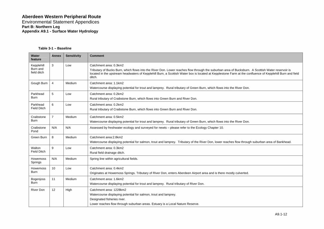
3.2.1 Table 3-1 summarises the watercourses crossed along the western section – for their location refer to Figure 9.1a-g. Refer to Table 2-1 for definition of sensitivity of water feature.
3.2.2 There is a range of sensitivities of the watercourses along the Northern Leg of the proposed AWPR caused by sensitive and protected ecosystems including trout and lamprey species. Gough Burn, Craibstone Burn, Bogenjoss Burn, have been assigned medium sensitivity and Goval Burn, River Don and Corby/Lily Loch SSSI have been assigned highest water feature sensitivity.
3.2.3 Howemoss Springs are located to the east of the proposed AWPR main line. The springs emerge along a contour line, at hedges within fields. These field ditches flow towards Aberdeen Airport business area. With respect to the groundwater catchment, refer to
Aberdeen Western Peripheral Route Environmental Statement Appendices Part B: Northern Leg Appendix A9.1 - Surface Water Hydrology
A9.1-10
Geology, Soils, Contaminated Land and Groundwater Chapter 8 (Groundwater section). However, groundwater flow is generally considered to be of low sensitivity in this area. Where wells are in close proximity (within 250m), sensitivity is considered to be moderate to high. In particular, this is evident at the A96 (ch. 317200 - 317225) and Newtonhill Overbridge (ch 327725 - 329725).
3.2.4 The River Don valley slightly narrows at the crossing point of the proposed AWPR. However, just upstream of this point and at the confluence with Goval Burn the valley gives space for wider flood plains. For further, more detailed information refer to the Hydrodynamics Appendix A9.2.
3.2.5 The Mill Lade system has been installed artificially and was used as a source of power for a pumping station. The Mill Lade takes water from the Goval Burn via a sluice gate and contours at a shallow gradient parallel to the Goval Burn. A small reservoir is located along the Mill Lade, both are located at a higher altitude than the Goval Burn. The Mill Lade flows through an artificial channel and a second sluice gate is located at the A947. In the past the Lade terminated above a pumping station near Goval Bridge where it would have fallen a substantial height down a pipe and eventually would have rejoined the Goval Burn. At present the Mill Lade is prevented from entering the pumping station and now outfalls directly to the Goval Burn via an overflow weir and pipe. (See Appendix A9.5, Annex 20 for a detailed description of the present state of the Mill Lade system).
3.2.6 Red Moss Burn originates from Red Moss and flows into Corby Loch, part of the Corby, Lilly and Bishops Lochs SSSI. For the significance of the SSSI, refer to Chapter 10 (Ecology and Nature Conservation). Corby Loch has a catchment area of about 3.6 km2 and includes Lily Loch (1.2 km2).
3.2.7 During a site visit in April 2005, it was noted that all watercourses in this section of the AWPR flow within well defined banks/embankments. No signs of recent flooding such as trash-lines were observed in the vicinity of the proposed crossing point of the AWPR. Estimates of bankfull flows suggest that none of the watercourses are likely to exceed the capacity of their well-defined watercourse corridors during a 1% AEP (1 in 100 year) flood. The River Don and Goval Burn has been investigated in further detail (refer to Hydrodynamics Appendix A9.2).
3.2.8 SEPA were approached for information on existing and indicative flood risk. Most watercourses along the proposed AWPR are ordinary watercourses and SEPA holds no information on these. The River Don is the only main river along the northern leg of the proposed AWPR. There is a SEPA gauging station at Park Hill Bridge a short distance downstream of the proposed crossing of the AWPR. Previous flooding occurred on the River Don around the Bridge of Don area (more than 10 km downstream of the proposed crossing), but no more detail could be given. Indicative flood risk maps of sufficient detail were not available from SEPA at the time of writing, however, second-generation flood maps are expected to be available in late 2006 or 2007.
3.2.9 Aberdeen City Council provided a map showing the historic flood extents of the September 1995, April 2000, October 2002 and November 2002 events on the River Don within the area of interest. (The November 2002 event was the largest and appears to have a return period of the order of 100 years). The map together with the OS 1:25,000 map shows that the upstream broad Don floodplain (which extends up to Elphinstone and in some places approaches a width of 1km) narrows to little more than the width of the river about 1km upstream of the proposed crossing. At the actual crossing point the floodplain has again widened but to a lesser extent (Figure 9.3a). The provided flood outline suggests that there are no properties in the immediate vicinity of the crossing at risk from flooding, but that a limited number of roads and property were affected during some of the events at Stoneywood and Bucksburn about 5 km downstream, further down at Bridge of Don.
Aberdeen Western Peripheral Route Environmental Statement Appendices Part B: Northern Leg Appendix A9.1 - Surface Water Hydrology
A9.1-11
3.2.10 Aberdeenshire Council holds no information on flooding or specific water uses on the watercourses along this stretch of the proposed scheme beyond what was provided by Aberdeen City Council.
3.3 Baseline Road Runoff
3.3.1 Hydrological soil parameters indicate that the ground conditions along the proposed AWPR are generally of average permeability with a slight increase in permeability in northern areas. Greenfield runoff rate was calculated at 4-5 l/s/ha for the 50% AEP (2 year return period) design flows.
3.4 Baseline Summary
3.4.1 In total the proposed AWPR northern leg crosses fourteen watercourses, a few field ditches and one artificial mill lade system. It also affects three small ponds and a SSSI comprising of two lochs. The major watercourse along the proposed route is the River Don, whilst the remaining watercourses are all relatively small.
3.4.2 The watercourse catchments are all mainly rural in character. All except the Don have small catchments (areas range between 0.2 to 40km2), whilst the River Don has a catchment area of about 1228 km2. Average annual rainfall along the route varies between 770 and 840mm, with a slight east to west increase, indicating a drier than average region within Scotland.
3.4.3 Soil parameters of the small catchments suggest middle range permeability and that they would be expected to display flow regimes of average sensitivity to rainfall. This is to say these catchments are unlikely to be especially flashy, but at the same time they will experience appreciable flood flows during and immediately following heavy rain (something that would not be so obvious in particularly permeable catchments). Within the range of responsiveness the Bogenjoss and Red Moss Burns are likely to be at the slightly flashier end, whilst the Goval Burn is likely to be less flashy. However, it is stressed that none of these catchments exhibit extreme response characteristics.
3.4.4 All the small watercourses flow within well-defined channel corridors where the route is proposed to cross them. Baseline flood risk from the watercourses is considered to be low in these areas. The evidence presented to the study suggests that downstream flood risk on these small watercourses is not recognised as being a problem.
3.4.5 The River Don has relatively wide flood plains in the vicinity of the proposed route, the flooding of which has been observed in recent extreme flood events. However, no properties appear to be at risk on the flood plain in the immediate vicinity of the proposed crossings. For a fuller appraisal refer to Hydrodynamics Appendix A9.2
Aberdeen Western Peripheral Route Environmental Statement Appendices Part B: Northern Leg Appendix A9.1 - Surface Water Hydrology
A9.1-12
Table 3-1 – Baseline
Water feature
Annex Sensitivity Comment
Kepplehill Burn and field ditch
3 Low Catchment area: 0.3km2Tributary of Bucks Burn, which flows into the River Don. Lower reaches flow through the suburban area of Bucksburn. A Scottish Water reservoir is located in the upstream headwaters of Kepplehill Burn, a Scottish Water box is located at Kepplestone Farm at the confluence of Kepplehill Burn and field ditch.
Gough Burn 4 Medium Catchment area: 1.1km2 Watercourse displaying potential for trout and lamprey. Rural tributary of Green Burn, which flows into the River Don.
Parkhead Burn
5 Low Catchment area: 0.2km2Rural tributary of Craibstone Burn, which flows into Green Burn and River Don.
Parkhead Field Ditch
6 Low Catchment area: 0.2km2Rural tributary of Craibstone Burn, which flows into Green Burn and River Don.
Craibstone Burn
7 Medium Catchment area: 0.5km2Watercourse displaying potential for trout and lamprey. Rural tributary of Green Burn, which flows into the River Don.
Craibstone Pond
N/A N/A Assessed by freshwater ecology and surveyed for newts – please refer to the Ecology Chapter 10.
Green Burn 8 Medium Catchment area:2.8km2Watercourse displaying potential for salmon, trout and lamprey. Tributary of the River Don, lower reaches flow through suburban area of Bankhead.
Walton Field Ditch
9 Low Catchment area: 0.3km2Rural field drainage ditch.
Howemoss Springs
N/A Medium Spring line within agricultural fields.
Howemoss Burn
10 Low Catchment area: 0.4km2Originates at Howemoss Springs. Tributary of River Don, enters Aberdeen Airport area and is there mostly culverted.
Bogenjoss Burn
11 Medium Catchment area: 1.6km2Watercourse displaying potential for trout and lamprey. Rural tributary of River Don.
River Don 12 High Catchment area: 1228km2Watercourse displaying potential for salmon, trout and lamprey. Designated fisheries river. Lower reaches flow through suburban areas. Estuary is a Local Nature Reserve.
Aberdeen Western Peripheral Route Environmental Statement Appendices Part B: Northern Leg Appendix A9.1 - Surface Water Hydrology
A9.1-13
Water feature
Annex Sensitivity Comment
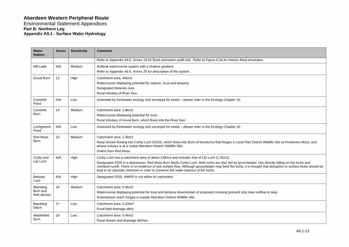
Refer to Appendix A9.5, Annex 19 for flood estimation audit trail. Refer to Figure 9.3a for historic flood envelopes.
Mill Lade N/A Medium Artificial watercourse system with a shallow gradient. Refer to Appendix A9.5, Annex 20 for description of the system.
Goval Burn 13 High Catchment area: 40km2Watercourse displaying potential for salmon, trout and lamprey. Designated fisheries river. Rural tributary of River Don.
Corsehill Pond
N/A Low Assessed by freshwater ecology and surveyed for newts – please refer to the Ecology Chapter 10.
Corsehill Burn
14 Medium Catchment area: 1.8km2Watercourse displaying potential for trout . Rural tributary of Goval Burn, which flows into the River Don.
Lochgreens Pond
N/A Low Assessed by freshwater ecology and surveyed for newts – please refer to the Ecology Chapter 10.
Red Moss Burn
15 Medium Catchment area: 1.3km2Rural stream flowing into Corby Loch (SSSI), which flows into Burn of Mundurno that fringes a Local Plan District Wildlife Site at Perwinnes Moss, and whose estuary is at a costal Aberdeen District Wildlife Site. Drains from Red Moss.
Corby and Lily Loch
N/A High Corby Loch has a catchment area of about 3.6km2 and includes that of Lily Loch (1.2km2). Designated SSSI in a depression. Red Moss Burn feeds Corby Loch. Both lochs are also fed by groundwater, rain directly falling on the lochs and overland runoff. There is no evidence of sub surface flow. Although groundwater may feed the lochs, it is thought that disruption to surface flows should be kept to an absolute minimum in order to preserve the water balance of the lochs.
Bishops Loch
N/A High Designated SSSI, AWPR is not within its catchment.
Blackdog Burn and field ditches
16 Medium Catchment area: 5.4km2Watercourse displaying potential for trout and lamprey downstream of proposed crossing (present only near outflow to sea). Downstream reach fringes a coastal Aberdeen District Wildlife Site.
Blackdog Ditich
17 Low Catchment area: 0.22km2
Rural field drainage ditch.
Middlefield Burn
18 Low Catchment area: 0.4km2Rural stream and drainage ditches.
Aberdeen Western Peripheral Route Environmental Statement Appendices Part B: Northern Leg Appendix A9.1 - Surface Water Hydrology
4 Potential Impacts
4.1 Introduction
4.1.1 Potential impacts on watercourses occur during both the construction and subsequent operation phases of the road.
4.2 Operation Impacts
4.2.1 Once built the road will coincide with or be adjacent to surface water features at a number of locations (mainly the crossing of watercourses but also environmental features critically dependent on the surface hydrology). Impacts of the road on surface hydrology are those that could affect the physical flow and water level regimes (for indirect impacts refer to relevant sections on Geomorphology (Appendix A9.3), Water Quality (Appendix A9.4) and Ecology (Chapter 10, Table 10.11 – Summary of Predicted Operational Impacts on Habitats and Species). Examples of such circumstances might include:
• Structures: Any resulting changes to surface water hydrology caused by structures, such as a blockage or constriction, may lead to localised flood risk; potential for increased sediment release and changes to erosion/depositional patterns. These impacts will indirectly affect the geomorphological and ecological status of a watercourse. When assessing the predicted / potential impacts of culverts all culverts will be considered to be flood flow culverts. Flood flow culverts are designed to convey the 0.5% AEP (200 year flow) but do not include any continuity of bed through the structure and do not have mammal ledges.
• Impermeable Areas: Building the road introduces new impermeable areas to the watercourse catchment which would not previously have been there. Hence this has the effect of increasing the overall volume of water reaching the watercourse, as less is lost to infiltration. Road runoff may reach the receiving watercourse earlier than if the road did not exist, resulting in the flood response of the catchment becoming more ‘flashy’. This may increase the flood risk downstream of the road outfall and as a result of increased stream power could potentially have profound effects on the geomorphological, water quality and ecological status of the watercourse.
• Outfall of Road Drainage: Road drainage will be piped to the appropriate outfall and then will flow into the specified watercourse. Some changes to the hydrologic and flood regimes of watercourses with outfalls may therefore potentially occur if no attenuation occurs.
• Increased Catchment: Re-direction of one watercourse into another / the construction of an outfall to a watercourse are often the results of a watercourse crossing design or drainage design. Such changes may result in changing the catchment of the watercourse leading to increases in local flow rates and flood risk. Alterations to flow may have implications for sedimentation patterns along the watercourse and thus increased flood risk else where along the watercourse through changes in channel dimensions. An increased stream power could also have profound affects on the geomorphological, water quality and ecological status of the watercourse.
• Severed Catchment: Constriction or severing of established flow paths may lead to an increased flood risk; changes to sediment regime via changes to gradient and size of watercourse leading to impact upon geomorphology and subsequently water quality. Alterations to the flow regime could also have profound affects on the ecological status of a watercourse.
• Blocked Pathways: The road and its drainage scheme may act as a barrier to current watercourse catchments; whereby rain is deposited in one catchment and by way of the drainage scheme discharged to another. This could increase flows to receiving
A9.1-14

Aberdeen Western Peripheral Route Environmental Statement Appendices Part B: Northern Leg Appendix A9.1 - Surface Water Hydrology
A9.1-15
watercourses while reducing flows in others. This would be of particular concern if blocked surface water pathways were of particular importance for an environmentally sensitive area such as a raised moss. A reduction in flows may greatly affect the geomorphological, water quality and ecological status of the watercourse.
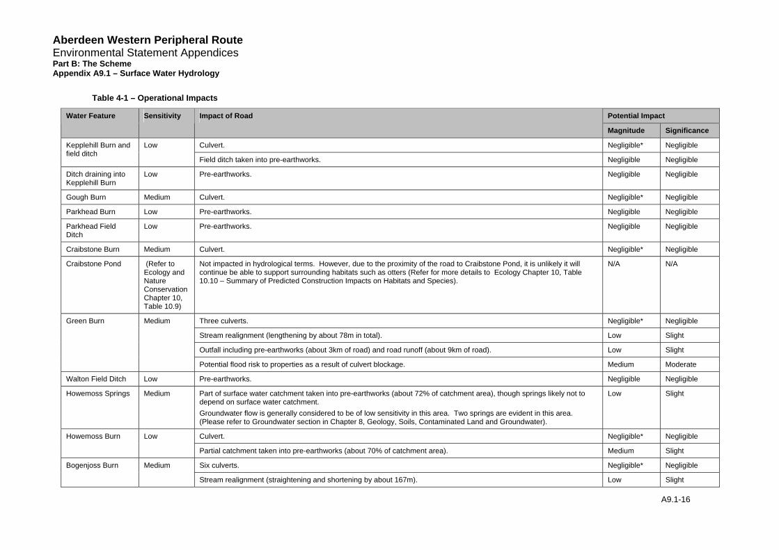
4.2.2 Table 4-1 summarises potential operation impacts and their impact significance on watercourses along the Northern Leg of the proposed AWPR.
Aberdeen Western Peripheral Route Environmental Statement Appendices Part B: The Scheme Appendix A9.1 – Surface Water Hydrology
Table 4-1 – Operational Impacts
Potential Impact Water Feature Sensitivity Impact of Road
Magnitude Significance
Culvert. Negligible* Negligible Kepplehill Burn and field ditch
Low
Field ditch taken into pre-earthworks. Negligible Negligible
Ditch draining into Kepplehill Burn
Low Pre-earthworks. Negligible Negligible
Gough Burn Medium Culvert. Negligible* Negligible
Parkhead Burn Low Pre-earthworks. Negligible Negligible
Parkhead Field Ditch
Low Pre-earthworks. Negligible Negligible
Craibstone Burn Medium Culvert. Negligible* Negligible
Craibstone Pond (Refer to Ecology and Nature Conservation Chapter 10, Table 10.9)
Not impacted in hydrological terms. However, due to the proximity of the road to Craibstone Pond, it is unlikely it will continue be able to support surrounding habitats such as otters (Refer for more details to Ecology Chapter 10, Table 10.10 – Summary of Predicted Construction Impacts on Habitats and Species).
N/A N/A
Three culverts. Negligible* Negligible
Stream realignment (lengthening by about 78m in total). Low Slight
Outfall including pre-earthworks (about 3km of road) and road runoff (about 9km of road). Low Slight
Green Burn Medium
Potential flood risk to properties as a result of culvert blockage. Medium Moderate
Walton Field Ditch Low Pre-earthworks. Negligible Negligible
Howemoss Springs Medium Part of surface water catchment taken into pre-earthworks (about 72% of catchment area), though springs likely not to depend on surface water catchment. Groundwater flow is generally considered to be of low sensitivity in this area. Two springs are evident in this area. (Please refer to Groundwater section in Chapter 8, Geology, Soils, Contaminated Land and Groundwater).
Low Slight
Culvert. Negligible* Negligible Howemoss Burn Low
Partial catchment taken into pre-earthworks (about 70% of catchment area). Medium Slight
Six culverts. Negligible* Negligible Bogenjoss Burn Medium
Stream realignment (straightening and shortening by about 167m). Low Slight
A9.1-16
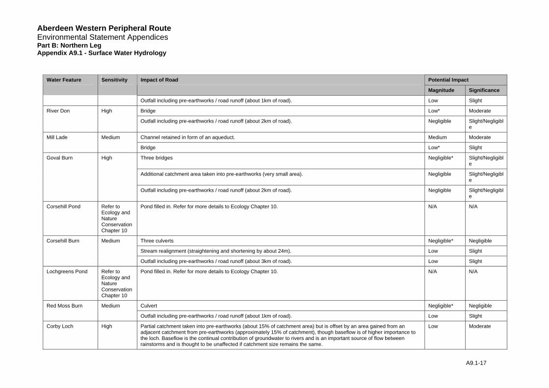
Aberdeen Western Peripheral Route Environmental Statement Appendices Part B: Northern Leg Appendix A9.1 - Surface Water Hydrology
Potential Impact Water Feature Sensitivity Impact of Road
Magnitude Significance
Outfall including pre-earthworks / road runoff (about 1km of road). Low Slight
Bridge Low* Moderate River Don High
Outfall including pre-earthworks / road runoff (about 2km of road). Negligible Slight/Negligible
Channel retained in form of an aqueduct. Medium Moderate Mill Lade Medium
Bridge Low* Slight
Three bridges Negligible* Slight/Negligible
Additional catchment area taken into pre-earthworks (very small area). Negligible Slight/Negligible
Goval Burn High
Outfall including pre-earthworks / road runoff (about 2km of road). Negligible Slight/Negligible
Corsehill Pond Refer to Ecology and Nature Conservation Chapter 10
Pond filled in. Refer for more details to Ecology Chapter 10. N/A N/A
Three culverts Negligible* Negligible
Stream realignment (straightening and shortening by about 24m). Low Slight
Corsehill Burn Medium
Outfall including pre-earthworks / road runoff (about 3km of road). Low Slight
Lochgreens Pond Refer to Ecology and Nature Conservation Chapter 10
Pond filled in. Refer for more details to Ecology Chapter 10. N/A N/A
Culvert Negligible* Negligible Red Moss Burn Medium
Outfall including pre-earthworks / road runoff (about 1km of road). Low Slight
Corby Loch High Partial catchment taken into pre-earthworks (about 15% of catchment area) but is offset by an area gained from an adjacent catchment from pre-earthworks (approximately 15% of catchment), though baseflow is of higher importance to the loch. Baseflow is the continual contribution of groundwater to rivers and is an important source of flow between rainstorms and is thought to be unaffected if catchment size remains the same.
Low Moderate
A9.1-17
Aberdeen Western Peripheral Route Environmental Statement Appendices Part B: Northern Leg Appendix A9.1 - Surface Water Hydrology
A9.1-18
Potential Impact Water Feature Sensitivity Impact of Road
Magnitude Significance
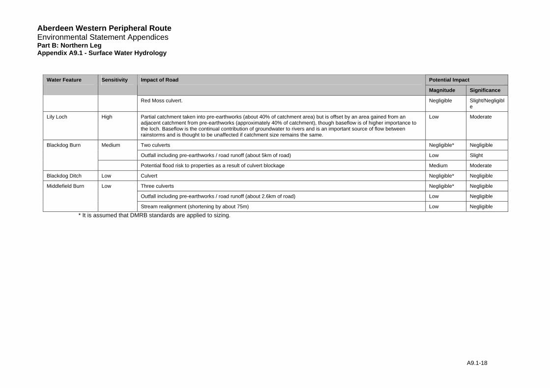
Red Moss culvert. Negligible Slight/Negligible
Lily Loch High Partial catchment taken into pre-earthworks (about 40% of catchment area) but is offset by an area gained from an adjacent catchment from pre-earthworks (approximately 40% of catchment), though baseflow is of higher importance to the loch. Baseflow is the continual contribution of groundwater to rivers and is an important source of flow between rainstorms and is thought to be unaffected if catchment size remains the same.
Low Moderate
Medium Two culverts Negligible* Negligible
Outfall including pre-earthworks / road runoff (about 5km of road) Low Slight
Blackdog Burn
Potential flood risk to properties as a result of culvert blockage Medium Moderate
Blackdog Ditch Low Culvert Negligible* Negligible
Low Three culverts Negligible* Negligible
Outfall including pre-earthworks / road runoff (about 2.6km of road) Low Negligible
Middlefield Burn
Stream realignment (shortening by about 75m) Low Negligible
* It is assumed that DMRB standards are applied to sizing.
Aberdeen Western Peripheral Route Environmental Statement Appendices Part B: Northern Leg Appendix A9.1 - Surface Water Hydrology
A9.1-19
4.3 Construction Impacts
4.3.1 Construction impacts in general can include effects such as soil compaction due to works traffic, sedimentation and disturbance / unintentional changes to channel dimensions which may impact on the hydraulic flow characteristics of a watercourse as well as on the geomorphology, ecology and water quality of the watercourse. These are referred to as “General construction impacts”.
4.3.2 During the construction phase other temporary works that will, or potentially might, have some bearing on the surface hydrology will include the following:
• watercourse diversions to facilitate culvert construction;
• from temporary works drainage outfalls;
• temporary works to facilitate bridge construction; or
• temporary arrangements will be required to control runoff during construction, where surface water could affect the works or the environmental performance of mitigation measures. This could include swales and geotextile-wrapped straw bale barriers.
4.3.3 Table 4-2 summarises potential construction impacts and their impact significance on watercourses along the Northern Leg of the proposed AWPR.

Aberdeen Western Peripheral Route Environmental Statement Appendices Part B: Northern Leg Appendix A9.1 - Surface Water Hydrology
Table 4-2 – Construction Impact Table
Potential Impacts Water Feature Sensitivity Impact of Road
Magnitude Significance
General construction impacts Low Negligible Kepplehill Burn and field ditch Low
Construction of culvert Medium Slight
Ditch draining into Kepplehill Burn
Low General construction impacts Low Negligible
General construction impacts Low Slight Gough Burn Medium
Construction of culvert Medium Moderate
Parkhead Burn Low General construction impacts Low Negligible
Parkhead Field Ditch Low General construction impacts Low Negligible
General construction impacts Low Slight Craibstone Burn Medium
Construction of culvert Medium Moderate
Craibstone Pond (Refer to Ecology and Nature Conservation Chapter 10, Table 10.9 )
Not impacted in Hydrological terms. However, due to the proximity of the road to Craibstone Pond, it is unlikely it will continue be able to support surrounding habitats such as otters (Refer for more details to Ecology Chapter 10, Table 10.10).
N/A N/A
General construction impacts Low Slight
Construction of culverts Medium Moderate
Green Burn Medium
Construction of stream realignment Medium Moderate
Walton Field Ditch Low General construction impacts Low Negligible
Howemoss Springs Medium General construction impacts Groundwater flow is generally considered to be of low sensitivity in this area. However, where wells are in close proximity (within 250m), sensitivity is considered to be moderate to high (Please refer to Groundwater section in Chapter 8, Geology, Soils, Contaminated Land and Groundwater).
Low Slight
General construction impacts Low Negligible Howmoss Burn Low
Construction of culvert Medium Slight
Bogenjoss Burn Medium General construction impacts Low Slight
A9.1-20
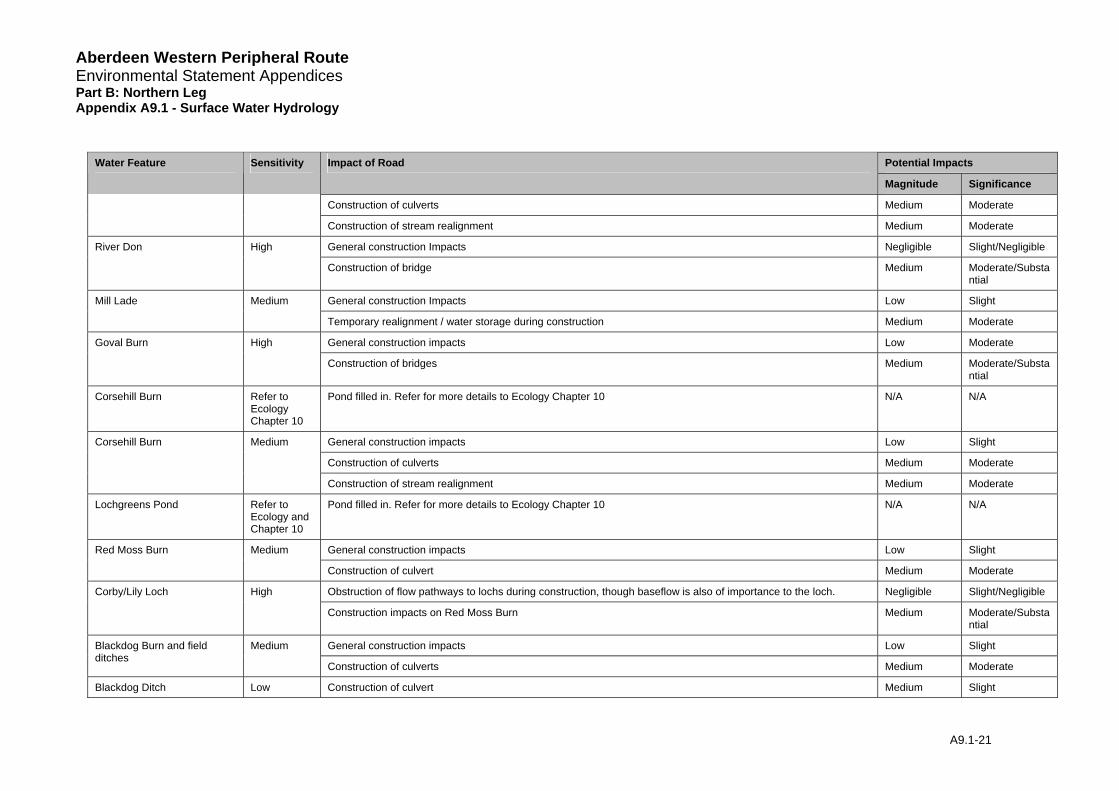
Aberdeen Western Peripheral Route Environmental Statement Appendices Part B: Northern Leg Appendix A9.1 - Surface Water Hydrology
Potential Impacts Water Feature Sensitivity Impact of Road
Magnitude Significance
Construction of culverts Medium Moderate
Construction of stream realignment Medium Moderate
General construction Impacts Negligible Slight/Negligible River Don High
Construction of bridge Medium Moderate/Substantial
General construction Impacts Low Slight Mill Lade Medium
Temporary realignment / water storage during construction Medium Moderate
General construction impacts Low Moderate Goval Burn High
Construction of bridges Medium Moderate/Substantial
Corsehill Burn Refer to Ecology Chapter 10
Pond filled in. Refer for more details to Ecology Chapter 10 N/A N/A
General construction impacts Low Slight
Construction of culverts Medium Moderate
Corsehill Burn Medium
Construction of stream realignment Medium Moderate
Lochgreens Pond Refer to Ecology and Chapter 10
Pond filled in. Refer for more details to Ecology Chapter 10 N/A N/A
General construction impacts Low Slight Red Moss Burn Medium
Construction of culvert Medium Moderate
Obstruction of flow pathways to lochs during construction, though baseflow is also of importance to the loch. Negligible Slight/Negligible Corby/Lily Loch High
Construction impacts on Red Moss Burn Medium Moderate/Substantial
General construction impacts Low Slight Blackdog Burn and field ditches
Medium
Construction of culverts Medium Moderate
Blackdog Ditch Low Construction of culvert Medium Slight
A9.1-21

Aberdeen Western Peripheral Route Environmental Statement Appendices Part B: Northern Leg Appendix A9.1 - Surface Water Hydrology
A9.1-22
Potential Impacts Water Feature Sensitivity Impact of Road
Magnitude Significance
General construction impacts Low Negligible
General construction impacts Low Negligible
Construction of culverts Medium Slight
Middlefield Burn Low
Construction of stream realignment Medium Slight
Aberdeen Western Peripheral Route Environmental Statement Appendices Part B: Northern Leg Appendix A9.1 - Surface Water Hydrology
4.4 Scheme Summary
4.4.1 Most impacts on surface water hydrology of the proposed AWPR and side roads are due to culverts / bridges, pre-earthworks and road drainage outfalls. These will be designed to current industry standards and legislation. Adequately designed culverts are thought to have only a Negligible impact on hydrological processes. However, there remains the potential risk of culvert blockage, this has been assessed separately and is detailed in Tables 4-1 and 4-2.
4.4.2 Based on the slope of the road, import and export of runoff from parts of other catchments may occur on a small scale. The road will generally impact on the downstream flow regime, particularly where significant modification to overland flow paths is likely and where culvert upgrading is proposed.
4.4.3 During operation:
• There no potential impacts of Substantial significance anticipated.
• There are no potential impacts of Moderate/Substantial significance anticipated,
• Potential impacts of Moderate significance are considered for:
• Green Burn,
• The River Don,
• Mill Lade.
• Corby and Lily Lochs, and
• Blackdog Burn
• Potential impacts on all remaining watercourses are considered to be of Slight or lesser significance.
4.4.4 During construction:
• There no potential impacts of Substantial significance anticipated,
• Potential impacts of Moderate/Substantial significance are anticipated for:
• The River Don,
• Goval Burn, and
• Corby and Lily Lochs.
• Potential impacts of Moderate significance are considered for:
• Gough Burn,
• Craibstone Burn
• Green Burn,
• Bogenjoss Burn,
• Mill Lade,
• Corsehill Burn,
• Red Moss Burn, and
• Blackdog Burn and field ditches
A9.1-23
Aberdeen Western Peripheral Route Environmental Statement Appendices Part B: Northern Leg Appendix A9.1 - Surface Water Hydrology 4.4.5 Potential impacts on all remaining watercourses are considered to be of Slight or lesser
significance.
4.4.6 The impact significance matrix shows that the combination of sensitivity of the water features and the magnitude of the potential impacts are Slight or Negligible on most watercourses and that construction impacts are more critical than operation impacts.
4.4.7 During the construction phase, potential impacts on the River Don, Goval Burn and Corby Loch SSSI are most significant due to their sensitivity. For these hydrological features to retain their functionality the sum of processes affecting them have to be taken into account. For further detail on potential impacts therefore see the Geomorphology Appendix (A9.3), Water Quality Appendix (A9.4) and the Ecology Chapter 10.
4.4.8 The catchments of Howemoss Springs and Ditch, Corby and Lily Lochs are affected by partial catchments being taken into pre-earthworks. Although the surface water catchment area is rather large the springs and lochs are thought to rather depend on groundwater, impact is therefore Low. See also Geology, Soils, Contaminated Land and Ground Water Chapter 8. Red Moss Burn is the main inflow into Corby Loch and is of significance to the hydrological regime of this SSSI.
4.4.9 The Mill Lade System is A-listed and is dependent on the Goval Burn. Changes to the channel dimensions, and in particular the shallow channel slope, may negatively impact on the hydrological regime of this artificial watercourse and flood risk of the surrounding land.
4.4.10 Green Burn, Gough, Craibstone, Bogenjoss, Corsehill, Red Moss and Blackdog Burns and Blackdog field ditch also potentially shows Moderate construction impacts during installation of culverts and stream realignment.
4.4.11 Two small ponds are affected by the scheme, namely Lochgreens and Corsehill Ponds. These lie directly on the alignment of the AWPR and will be infilled. Hydrologically these are rather insignificant features and therefore the impact of removing these features has been assessed as Negligible. See Ecology Chapter 10 for further discussion Table 10.9 and 10.10.
5 Mitigation and Recommendations
5.1 Mitigation
5.1.1 Mitigation measures are based on current good practice for highway drainage design, including the DMRB and guidance provided in ‘Sustainable Urban Drainage Systems: design manual for Scotland and Northern Ireland CIRIA C521’ (Construction Industry Research and Information Association (CIRIA), 2000). It is presumed that legal regulations and guidance as outlined in the Water Environment and Water Services (Scotland) Act 2003 and supported by the Controlled Activities Regulations (Scotland) 2005, and SPP7 are followed.
5.1.2 These require:
• culvert and bridges are designed to appropriate return period flows. More detail is listed below;
• culvert and bridges do not impinge on flood plains, do not obstruct flows nor easily catch debris and block up. A regular maintenance regime should be set in place;
• new culverts or bridges are not smaller than any existing ones in the vicinity or upstream of the new road scheme (unless obviously over-designed);
A9.1-24
Aberdeen Western Peripheral Route Environmental Statement Appendices Part B: Northern Leg Appendix A9.1 - Surface Water Hydrology
• road drainage and pre-earthworks do not enhance flood event runoff into streams compared to the pre-development situation and therefore allow for storage and attenuation before outfall;
• road drainage and pre-earthworks should be designed to minimise transfer of water across catchments, outfalls are located at frequent intervals;
• stream alignment does not impact on flood risk, which may be achieved by maintaining stream capacities and channel length / slope and avoidance of sharp bends; and
• development is designed such that it does not materially increase pre-development flood risk.
Crossing Structures
5.1.3 Culvert and bridges will be designed to appropriate return period flows. SEPA requires a design to return period of at least 0.5% AEP (1 in 200 years return period). SPP7 states that this return period already includes an allowance for climate change. All culverts will therefore be designed to the 0.5% AEP (200 year return period) for individual watercourses.
5.1.4 All culverts will be boxed depression invert culverts. There will be substrate added to the culvert bed, mammal ledges to allow the passage of animals and be designed following guidance to make them suitable for fish passage. The design of the culverts follows guidance from the Scottish Executive on culverts and migratory fish (SEERAD, 2000).
5.1.5 Culvert and bridges must not impinge on floodplains, or obstruct flows nor easily catch debris and become blocked. A regular maintenance regime should be set in place to prevent any blockages around culverts and bridge piers that could reduce the capacity of the structure. This may include the removal of debris and dead vegetation from the channel and banks upstream of the structure.
5.1.6 New culverts or bridges are not smaller than any existing ones in the vicinity or upstream of the new road scheme (unless obviously over-designed).
Realignments
5.1.7 In general, any new alignments should maintain existing channel dimensions (width and depth). Where necessary, changes in gradient should be compensated for by varying the channel sinuosity (planform), width and depth.
5.1.8 Any existing storage areas within the realigned area should also be replaced to maintain the capacity of the watercourse, prevent flood risk and sustain connectivity to downstream areas.
5.1.9 At sites of large realignments (greater than 50m length water), it may be necessary to contact a period of monitoring after construction to reassess the effects on flood risk.
Road Drainage
5.1.10 Road drainage and pre-earthworks do not enhance flood event runoff into streams compared to the pre-development situation and therefore allow for storage and attenuation before outfall. This may be achieved within the road ditches and pipes or in specially designed storage basins (SUDS) to appropriate design return period flows. (Refer to the Water Quality Appendix A9.4 for more detail on the proposed SUDS detention and treatment ponds for this scheme).
5.1.11 Road drainage and pre-earthworks should be designed to minimise transfer of water across catchments. Outfalls should be located at frequent intervals to avoid the transfer of surface water from one catchment to another. An effective drainage system should avoid where
A9.1-25
Aberdeen Western Peripheral Route Environmental Statement Appendices Part B: Northern Leg Appendix A9.1 - Surface Water Hydrology
possible storage / flooding of water on land next to the road on the upstream side of newly created embankments.
5.1.12 The proposed road drainage scheme consists of three stages, which ensure flood flows up to the 0.5% AEP (200 year event) are accounted for in the road drainage scheme (based on SPP7, which uses the 0.5% AEP as a guide to account for climate change). Any flows beyond the 0.5% AEP (1:200 year event) are not accounted for by the proposed road scheme. The components of the road drainage scheme are shown below:
Filter Drains:
5.1.13 Flow from the road is proposed to be taken into filter drains at the edge of the road, which will flow into detention basins before out falling to the relevant watercourse. The filter drains will be designed to the 50% AEP (1:2 year flow) in order to account for climate change. The filter drains are further checked for surcharging for the 10% AEP (1:10 year flow) and therefore may be assessed as being designed to hold up to the 10% AEP.
Pre-Earthwork Ditches:
5.1.14 Flow above the 10% AEP (1:10 year) threshold up to the 1.33% AEP (1:75 year flow) will be taken into the pre-earthwork ditches, which will run parallel with the road. The pre-earthwork ditches are therefore designed to the 1.33% AEP which is specified in the DMRB (reference HA106/04).
Detention Basins:
5.1.15 The third stage of the proposed road drainage scheme is the detention basins. These are designed to attenuate the 1% AEP (1:100 year flood event) down to discharging the pre-development QMED flow (the pre-development QMED Greenfield runoff). In order to account for climate change the basins are further checked to ensure the freeboard allowance allows the 0.5% AEP (1:200 year event) to be stored in the detention basin, prior to release. The road drainage design scheme has been designed to ensure where possible flows between the 1.33% AEP (75 year) and 1-0.5% AEP (100/200 year event) will flow either down the road or overspill along the ditches to the detention basins prior to out falling to the receiving watercourse.
5.2 Operation Mitigation and Recommendations
5.2.1 Recommendations for areas with Moderate and Substantial operation impact significance with respect to surface water hydrology are highlighted in Table 5-1. All mitigation with respect to ponds (Craibstone, Corsehill and Lochgreens Pond) is included as part of the Ecological assessment and is detailed in Chapter 10 (Ecology and Nature Conservation) and summarised in Chapter 9 (Water Environment).
Table 5-1– Surface Water Hydrology Mitigation Measures for the Operation
Water Feature
Impact Mitigation Measure
Flood risk at culvert inlet
Regular maintenance of the culvert entrance. Regular maintenance and removal of debris along banks of burn upstream of the entrance.
Green Burn
Outfall Alleviate flows to greenfield runoff rates Or avoid outfall altogether
Stream realignment Retain stream capacity and slope Retrain channel roughness by naturalising bed sediment and planting of embankments.
Bogenjoss Burn
Outfall Alleviate flows to greenfield runoff rates
A9.1-26
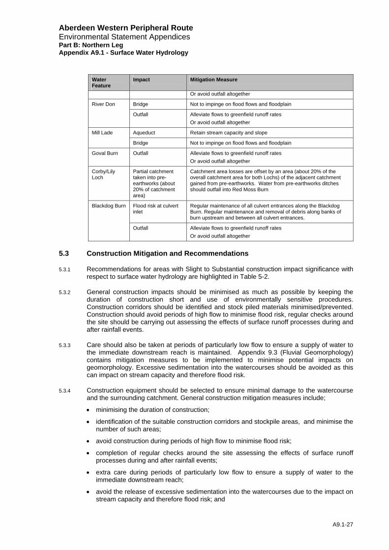
Aberdeen Western Peripheral Route Environmental Statement Appendices Part B: Northern Leg Appendix A9.1 - Surface Water Hydrology
Water Impact Mitigation Measure Feature
Or avoid outfall altogether
Bridge Not to impinge on flood flows and floodplain River Don
Outfall Alleviate flows to greenfield runoff rates Or avoid outfall altogether
Aqueduct Retain stream capacity and slope Mill Lade
Bridge Not to impinge on flood flows and floodplain
Goval Burn Outfall Alleviate flows to greenfield runoff rates Or avoid outfall altogether
Corby/Lily Loch
Partial catchment taken into pre-earthworks (about 20% of catchment area)
Catchment area losses are offset by an area (about 20% of the overall catchment area for both Lochs) of the adjacent catchment gained from pre-earthworks. Water from pre-earthworks ditches should outfall into Red Moss Burn
Flood risk at culvert inlet
Regular maintenance of all culvert entrances along the Blackdog Burn. Regular maintenance and removal of debris along banks of burn upstream and between all culvert entrances.
Blackdog Burn
Outfall Alleviate flows to greenfield runoff rates Or avoid outfall altogether
5.3 Construction Mitigation and Recommendations
5.3.1 Recommendations for areas with Slight to Substantial construction impact significance with respect to surface water hydrology are highlighted in Table 5-2.
5.3.2 General construction impacts should be minimised as much as possible by keeping the duration of construction short and use of environmentally sensitive procedures. Construction corridors should be identified and stock piled materials minimised/prevented. Construction should avoid periods of high flow to minimise flood risk, regular checks around the site should be carrying out assessing the effects of surface runoff processes during and after rainfall events.
5.3.3 Care should also be taken at periods of particularly low flow to ensure a supply of water to the immediate downstream reach is maintained. Appendix 9.3 (Fluvial Geomorphology) contains mitigation measures to be implemented to minimise potential impacts on geomorphology. Excessive sedimentation into the watercourses should be avoided as this can impact on stream capacity and therefore flood risk.
5.3.4 Construction equipment should be selected to ensure minimal damage to the watercourse and the surrounding catchment. General construction mitigation measures include;
• minimising the duration of construction;
• identification of the suitable construction corridors and stockpile areas, and minimise the number of such areas;
• avoid construction during periods of high flow to minimise flood risk;
• completion of regular checks around the site assessing the effects of surface runoff processes during and after rainfall events;
• extra care during periods of particularly low flow to ensure a supply of water to the immediate downstream reach;
• avoid the release of excessive sedimentation into the watercourses due to the impact on stream capacity and therefore flood risk; and
A9.1-27
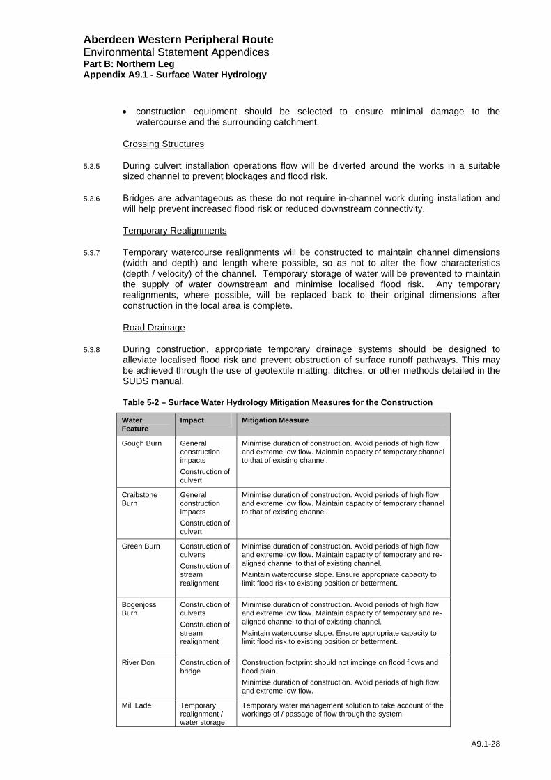
Aberdeen Western Peripheral Route Environmental Statement Appendices Part B: Northern Leg Appendix A9.1 - Surface Water Hydrology
• construction equipment should be selected to ensure minimal damage to the watercourse and the surrounding catchment.
Crossing Structures
5.3.5 During culvert installation operations flow will be diverted around the works in a suitable sized channel to prevent blockages and flood risk.
5.3.6 Bridges are advantageous as these do not require in-channel work during installation and will help prevent increased flood risk or reduced downstream connectivity.
Temporary Realignments
5.3.7 Temporary watercourse realignments will be constructed to maintain channel dimensions (width and depth) and length where possible, so as not to alter the flow characteristics (depth / velocity) of the channel. Temporary storage of water will be prevented to maintain the supply of water downstream and minimise localised flood risk. Any temporary realignments, where possible, will be replaced back to their original dimensions after construction in the local area is complete.
Road Drainage
5.3.8 During construction, appropriate temporary drainage systems should be designed to alleviate localised flood risk and prevent obstruction of surface runoff pathways. This may be achieved through the use of geotextile matting, ditches, or other methods detailed in the SUDS manual.
Table 5-2 – Surface Water Hydrology Mitigation Measures for the Construction
Water Feature
Impact Mitigation Measure
Gough Burn General construction impacts Construction of culvert
Minimise duration of construction. Avoid periods of high flow and extreme low flow. Maintain capacity of temporary channel to that of existing channel.
Craibstone Burn
General construction impacts Construction of culvert
Minimise duration of construction. Avoid periods of high flow and extreme low flow. Maintain capacity of temporary channel to that of existing channel.
Green Burn Construction of culverts Construction of stream realignment
Minimise duration of construction. Avoid periods of high flow and extreme low flow. Maintain capacity of temporary and re-aligned channel to that of existing channel. Maintain watercourse slope. Ensure appropriate capacity to limit flood risk to existing position or betterment.
Bogenjoss Burn
Construction of culverts Construction of stream realignment
Minimise duration of construction. Avoid periods of high flow and extreme low flow. Maintain capacity of temporary and re-aligned channel to that of existing channel. Maintain watercourse slope. Ensure appropriate capacity to limit flood risk to existing position or betterment.
River Don Construction of bridge
Construction footprint should not impinge on flood flows and flood plain. Minimise duration of construction. Avoid periods of high flow and extreme low flow.
Mill Lade Temporary realignment / water storage
Temporary water management solution to take account of the workings of / passage of flow through the system.
A9.1-28
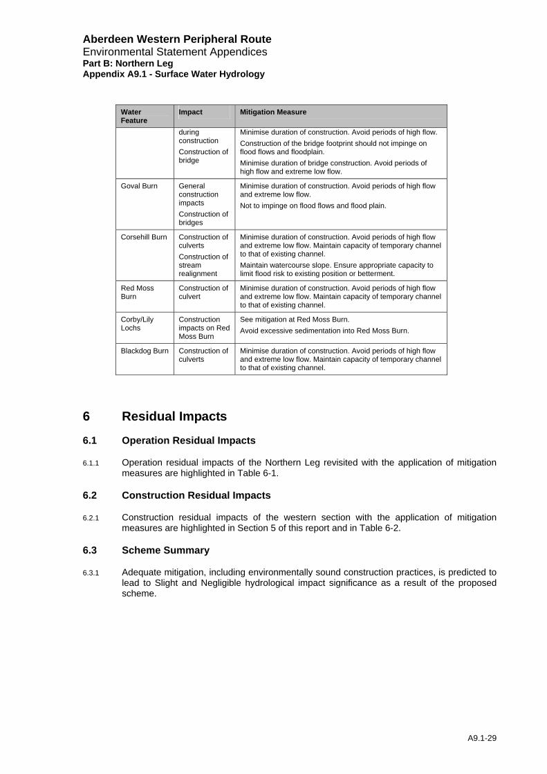
Aberdeen Western Peripheral Route Environmental Statement Appendices Part B: Northern Leg Appendix A9.1 - Surface Water Hydrology
A9.1-29
Water Feature
Impact Mitigation Measure
during construction Construction of bridge
Minimise duration of construction. Avoid periods of high flow. Construction of the bridge footprint should not impinge on flood flows and floodplain. Minimise duration of bridge construction. Avoid periods of high flow and extreme low flow.
Goval Burn General construction impacts Construction of bridges
Minimise duration of construction. Avoid periods of high flow and extreme low flow. Not to impinge on flood flows and flood plain.
Corsehill Burn Construction of culverts Construction of stream realignment
Minimise duration of construction. Avoid periods of high flow and extreme low flow. Maintain capacity of temporary channel to that of existing channel. Maintain watercourse slope. Ensure appropriate capacity to limit flood risk to existing position or betterment.
Red Moss Burn
Construction of culvert
Minimise duration of construction. Avoid periods of high flow and extreme low flow. Maintain capacity of temporary channel to that of existing channel.
Corby/Lily Lochs
Construction impacts on Red Moss Burn
See mitigation at Red Moss Burn. Avoid excessive sedimentation into Red Moss Burn.
Blackdog Burn Construction of culverts
Minimise duration of construction. Avoid periods of high flow and extreme low flow. Maintain capacity of temporary channel to that of existing channel.
6 Residual Impacts
6.1 Operation Residual Impacts
6.1.1 Operation residual impacts of the Northern Leg revisited with the application of mitigation measures are highlighted in Table 6-1.
6.2 Construction Residual Impacts
6.2.1 Construction residual impacts of the western section with the application of mitigation measures are highlighted in Section 5 of this report and in Table 6-2.
6.3 Scheme Summary
6.3.1 Adequate mitigation, including environmentally sound construction practices, is predicted to lead to Slight and Negligible hydrological impact significance as a result of the proposed scheme.

Aberdeen Western Peripheral Route Environmental Statement Appendices Part B: Northern Leg Appendix A9.1 - Surface Water Hydrology
Table 6-1 – Operation Residual Impact
Residual Impact Water Feature
Sensitivity Impact of Road Mitigation
Magnitude Significance
Culvert Appropriate design Negligible Negligible Kepplehill Burn and field ditch
Low
Pre-earthworks Appropriate design Negligible Negligible
Ditch draining into Kepplehill Burn
Low Pre-earthworks Appropriate design Negligible Negligible
Culvert Appropriate design Negligible Negligible Gough Burn Medium
Outfall See Table 5-1 Road drainage (within design limits) to SUDS treatment area at Green Burn
Negligible Negligible
Parkhead Burn
Low Pre-earthworks Appropriate design Negligible Negligible
Parkhead Field Ditch
Low Pre-earthworks Appropriate design Negligible Negligible
Craibstone Pond
N/A. Not impacted. Refer for more details to Ecology Chapter 10, table 10.10.
N/A. N/A. Refer to Ecology Chapter 10, table 10.10.
Craibstone Burn
Medium Culvert Appropriate design Negligible Negligible
Culverts Appropriate design Negligible Negligible
Stream alignment See Table 5-1 Avoid sharp bends. Retain capacity and slope. Naturalise (e.g. sediment, plants).
Negligible Negligible
Outfall Detention, filter drain and treatment ponds Negligible Negligible
Green Burn Medium
Potential flood risk to properties as a result of culvert blockage
Maintenance of culvert entrance and clearance of upstream banks.
Low Slight
Walton Field Ditch
Low Pre-earthworks Appropriate design Negligible Negligible
A9.1-30
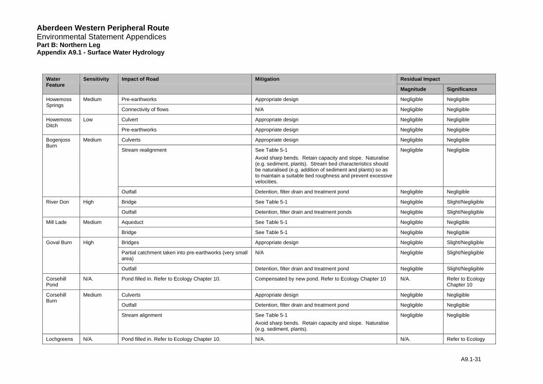
Aberdeen Western Peripheral Route Environmental Statement Appendices Part B: Northern Leg Appendix A9.1 - Surface Water Hydrology
Residual Impact Water Sensitivity Impact of Road Mitigation Feature
Magnitude Significance
Pre-earthworks Appropriate design Negligible Negligible Howemoss Springs
Medium
Connectivity of flows N/A Negligible Negligible
Culvert Appropriate design Negligible Negligible Howemoss Ditch
Low
Pre-earthworks Appropriate design Negligible Negligible
Culverts Appropriate design Negligible Negligible
Stream realignment See Table 5-1 Avoid sharp bends. Retain capacity and slope. Naturalise (e.g. sediment, plants). Stream bed characteristics should be naturalised (e.g. addition of sediment and plants) so as to maintain a suitable bed roughness and prevent excessive velocities.
Negligible Negligible
Bogenjoss Burn
Medium
Outfall Detention, filter drain and treatment pond Negligible Negligible
Bridge See Table 5-1 Negligible Slight/Negligible River Don High
Outfall Detention, filter drain and treatment ponds Negligible Slight/Negligible
Aqueduct See Table 5-1 Negligible Negligible Mill Lade Medium
Bridge See Table 5-1 Negligible Negligible
Bridges Appropriate design Negligible Slight/Negligible
Partial catchment taken into pre-earthworks (very small area)
N/A Negligible Slight/Negligible
Goval Burn High
Outfall Detention, filter drain and treatment pond Negligible Slight/Negligible
Corsehill Pond
N/A. Pond filled in. Refer to Ecology Chapter 10. Compensated by new pond. Refer to Ecology Chapter 10 N/A. Refer to Ecology Chapter 10
Culverts Appropriate design Negligible Negligible
Outfall Detention, filter drain and treatment pond Negligible Negligible
Corsehill Burn
Medium
Stream alignment See Table 5-1 Avoid sharp bends. Retain capacity and slope. Naturalise (e.g. sediment, plants).
Negligible Negligible
Lochgreens N/A. Pond filled in. Refer to Ecology Chapter 10. N/A. N/A. Refer to Ecology
A9.1-31
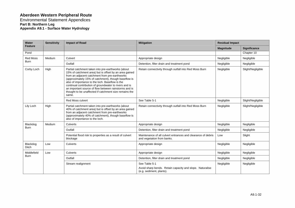
Aberdeen Western Peripheral Route Environmental Statement Appendices Part B: Northern Leg Appendix A9.1 - Surface Water Hydrology
Residual Impact Water Sensitivity Impact of Road Mitigation Feature
Magnitude Significance Pond Chapter 10
Culvert Appropriate design Negligible Negligible Red Moss Burn
Medium
Outfall Detention, filter drain and treatment pond Negligible Negligible
Partial catchment taken into pre-earthworks (about 15% of catchment area) but is offset by an area gained from an adjacent catchment from pre-earthworks (approximately 15% of catchment), though baseflow is also of importance to the loch. Baseflow is the continual contribution of groundwater to rivers and is an important source of flow between rainstorms and is thought to be unaffected if catchment size remains the same.
Retain connectivity through outfall into Red Moss Burn Negligible Slight/Negligible Corby Loch High
Red Moss culvert See Table 5-1 Negligible Slight/Negligible
Lily Loch High Partial catchment taken into pre-earthworks (about 40% of catchment area) but is offset by an area gained from an adjacent catchment from pre-earthworks (approximately 40% of catchment), though baseflow is also of importance to the loch.
Retain connectivity through outfall into Red Moss Burn Negligible Slight/Negligible
Culverts Appropriate design Negligible Negligible
Outfall Detention, filter drain and treatment pond Negligible Negligible
Blackdog Burn
Medium
Potential flood risk to properties as a result of culvert blockage
Maintenance of all culvert entrances and clearance of debris and vegetation from banks.
Low Slight
Blackdog Ditch
Low Culverts Appropriate design Negligible Negligible
Culverts Appropriate design Negligible Negligible
Outfall Detention, filter drain and treatment pond Negligible Negligible
Middlefield Burn
Low
Stream realignment See Table 5-1 Avoid sharp bends. Retain capacity and slope. Naturalise (e.g. sediment, plants).
Negligible Negligible
A9.1-32
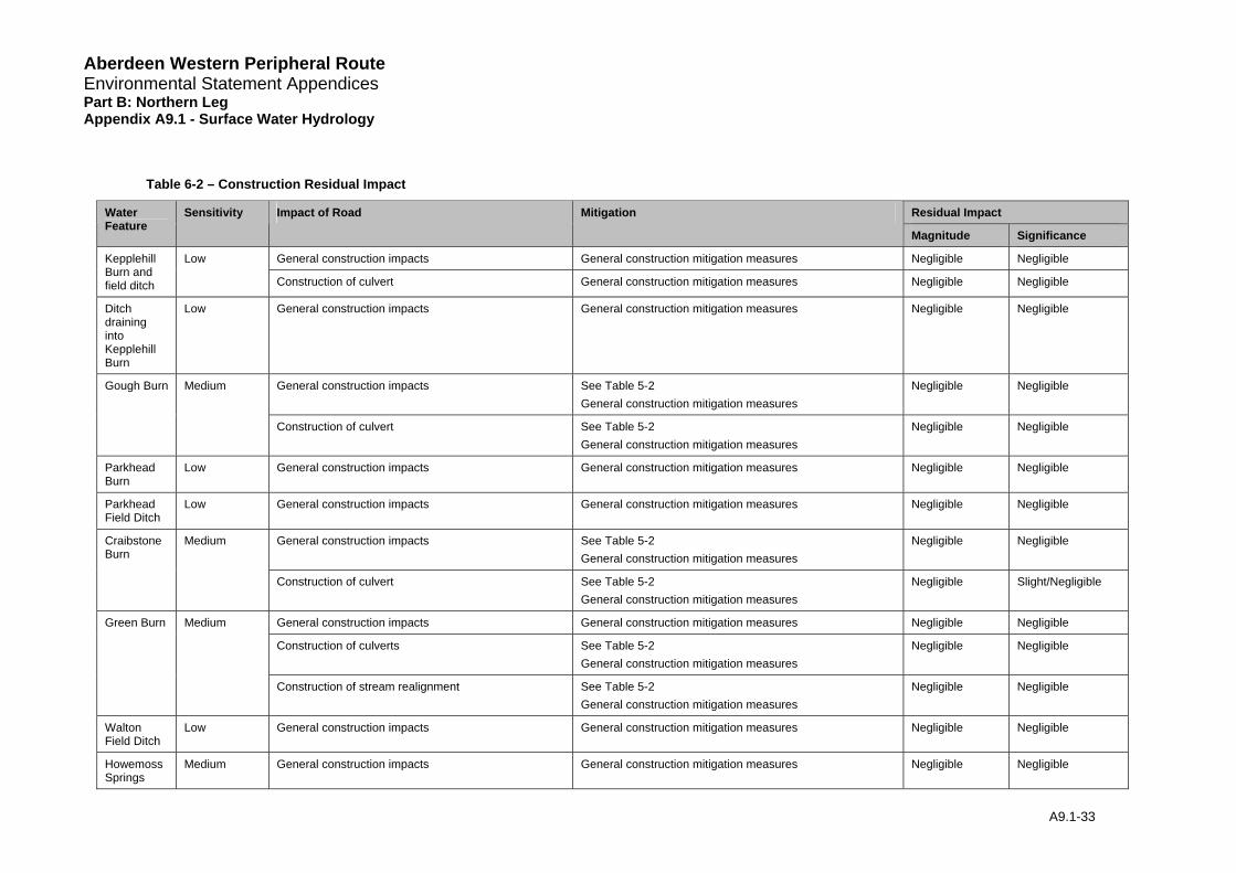
Aberdeen Western Peripheral Route Environmental Statement Appendices Part B: Northern Leg Appendix A9.1 - Surface Water Hydrology
Table 6-2 – Construction Residual Impact
Residual Impact Water Feature
Sensitivity Impact of Road Mitigation
Magnitude Significance
General construction impacts General construction mitigation measures Negligible Negligible Kepplehill Burn and field ditch
Low
Construction of culvert General construction mitigation measures Negligible Negligible
Ditch draining into Kepplehill Burn
Low General construction impacts General construction mitigation measures Negligible Negligible
General construction impacts See Table 5-2 General construction mitigation measures
Negligible Negligible Gough Burn Medium
Construction of culvert See Table 5-2 General construction mitigation measures
Negligible Negligible
Parkhead Burn
Low General construction impacts General construction mitigation measures Negligible Negligible
Parkhead Field Ditch
Low General construction impacts General construction mitigation measures Negligible Negligible
General construction impacts See Table 5-2 General construction mitigation measures
Negligible Negligible Craibstone Burn
Medium
Construction of culvert See Table 5-2 General construction mitigation measures
Negligible Slight/Negligible
General construction impacts General construction mitigation measures Negligible Negligible
Construction of culverts See Table 5-2 General construction mitigation measures
Negligible Negligible
Green Burn Medium
Construction of stream realignment See Table 5-2 General construction mitigation measures
Negligible Negligible
Walton Field Ditch
Low General construction impacts General construction mitigation measures Negligible Negligible
Howemoss Springs
Medium General construction impacts General construction mitigation measures Negligible Negligible
A9.1-33
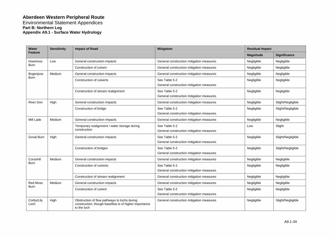
Aberdeen Western Peripheral Route Environmental Statement Appendices Part B: Northern Leg Appendix A9.1 - Surface Water Hydrology
Residual Impact Water Sensitivity Impact of Road Mitigation Feature
Magnitude Significance
General construction impacts General construction mitigation measures Negligible Negligible Howmoss Burn
Low
Construction of culvert General construction mitigation measures Negligible Negligible
General construction impacts General construction mitigation measures Negligible Negligible
Construction of culverts See Table 5-2 General construction mitigation measures
Negligible Negligible
Bogenjoss Burn
Medium
Construction of stream realignment See Table 5-2 General construction mitigation measures
Negligible Negligible
General construction Impacts General construction mitigation measures Negligible Slight/Negligible River Don High
Construction of bridge See Table 5-2 General construction mitigation measures
Negligible Slight/Negligible
General construction Impacts General construction mitigation measures Negligible Negligible Mill Lade Medium
Temporary realignment / water storage during construction
See Table 5-2 General construction mitigation measures
Low Slight
General construction impacts See Table 5-2 General construction mitigation measures
Negligible Slight/Negligible Goval Burn High
Construction of bridges See Table 5-2 General construction mitigation measures
Negligible Slight/Negligible
General construction impacts General construction mitigation measures Negligible Negligible
Construction of culverts See Table 5-2 General construction mitigation measures
Negligible Negligible
Corsehill Burn
Medium
Construction of stream realignment General construction mitigation measures Negligible Negligible
General construction impacts General construction mitigation measures Negligible Negligible Red Moss Burn
Medium
Construction of culvert See Table 5-2 General construction mitigation measures
Negligible Negligible
Corby/Lily Loch
High Obstruction of flow pathways to lochs during construction, though baseflow is of higher importance to the loch
General construction mitigation measures Negligible Slight/Negligible
A9.1-34
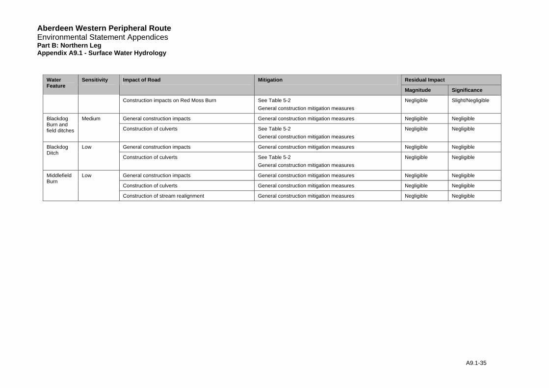
Aberdeen Western Peripheral Route Environmental Statement Appendices Part B: Northern Leg Appendix A9.1 - Surface Water Hydrology
A9.1-35
Residual Impact Water Feature
Sensitivity Impact of Road Mitigation
Magnitude Significance
Construction impacts on Red Moss Burn See Table 5-2 General construction mitigation measures
Negligible Slight/Negligible
General construction impacts General construction mitigation measures Negligible Negligible Blackdog Burn and field ditches
Medium
Construction of culverts See Table 5-2 General construction mitigation measures
Negligible Negligible
General construction impacts General construction mitigation measures Negligible Negligible Blackdog Ditch
Low
Construction of culverts See Table 5-2 General construction mitigation measures
Negligible Negligible
General construction impacts General construction mitigation measures Negligible Negligible
Construction of culverts General construction mitigation measures Negligible Negligible
Middlefield Burn
Low
Construction of stream realignment General construction mitigation measures Negligible Negligible
Aberdeen Western Peripheral Route Environmental Statement Appendices Part B: Northern Leg Appendix A9.1 - Surface Water Hydrology
7 References
Centre for Hydrology and Ecology (2003). Hydrological Data United Kingdom: Hydrometric Register and Statistics, 1996-2000, Wallingford.
CIRIA (2000). Sustainable Urban Drainage Systems: Design manual for Scotland and Northern Ireland, Report No CIRIA C521, Construction Industry Research and Information Association, London.
HR Wallingford, (1994). RIBAMAN, User Manual Version 1.22A. Wallingford
Institute of Hydrology (1999). Flood Estimation Handbook Vol1-5 and associated software. Wallingford.
Institute of Hydrology (1994). Flood estimation for small catchments. Report No IH124, Wallingford.
Maidment. D. R. (1993). Handbook of Hydrology. McGraw-Hill, Inc.
Price. D. J and McKenna. J. E. (2003). Climate Change: Review of Levels of Protection Offered by Flood Prevention Schemes UKCIP02 Update (2003). Environment Group Research Report.
Scottish Executive ‘Scottish Planning Policy (2004). Scottish Planning Policy SPP 7: Planning and Flooding.
SEPA. (2005). The Water Environment (Controlled Activities) (Scotland) Regulations. A Practical Guide.
Sutcliffe. J. V. (1978). A Guide to the Flood Studies Report. Institute of Hydrology Report No. 48.
The Highways Agency, Scottish Executive, Welsh Assembly Government, The Department for Regional Development Northern Ireland (2004). Design Manual for Roads and Bridges (DMRB) Volume 4, Section 2 “Drainage”. Wilson. S. Bray. R. Cooper. P. (2004). Sustainable drainage systems. Hydraulic, structural and water quality advice (C609). CIRIA
Young A. R., Grew R. and Holmes M.G.R. (2003). Low Flows 2000: A national water resources assessment and decision support. Water Science and Technology, 48 (10).
A9.1-36
Aberdeen Western Peripheral Route Environmental Statement Appendices Part B: Northern Leg Appendix A9.1 - Surface Water Hydrology
8 Glossary
AEP Annual Exceedence Probability
AREA Catchment Drainage Area (km2)
AWPR Aberdeen Western Peripheral Road
Baseflow Is the continual contribution of groundwater to rivers and is an important source of flow between rainstorms.
BFIHOST Base Flow Index derived using the HOST classification.
FARL Index of Flood Attenuation due to Reservoirs and Lakes
FDC Flow Duration Curve - A cumulative frequency curve that shows the percentage of time that specified discharges are equalled or exceeded.
FEH Flood Estimation Handbook (see references)
FFC Flood Frequency Curve – A graph showing the recurrence intervals (return periods) that floods of magnitude are equalled or exceeded
HOST Hydrology of Soil Types Classification
LF2000 Low Flows 2000
OS Ordnance Survey
QBAR Mean Annual Flood (m3/s)
QBF Bankfull Flow: the bank is defined at the point where vegetation/soil cover obviously changes between water and air
QEBF Embankmentfull Flow: the embankment (top of) is defined as the point where water would spill into wider areas (fields/road)
q green Greenfield runoff rate (l/s/ha)
Qmean Mean Flow (m3/s)
QMED Median Annual Flood Flow (m3/s) (flow with a 2 year return period)
Q95 Flow that is expected to be exceeded 95% of the time (m3/s)
Q-Tyr (eg Q-5yr) Flow associated with a T-year return period (eg 5-year flow)
SAAR 1961-90 standard-period average annual rainfall (mm)
SAC Special Area of Conservation
SPRHOST Standard Percentage Runoff (%) derived using HOST classification
SSSI Site of Special Scientific Interest
A9.1-37

Aberdeen Western Peripheral Route Environmental Statement Appendices Part B: Northern Leg Appendix A9.1 - Surface Water Hydrology
SUDS Sustainable Urban Drainage Systems
URBEXT1990 FEH index of fractional urban extent for 1990.
V Velocity (m/s)
A9.1-38