A82 Tarbet to Fort William Route Action Plan Study ... · Transport Scotland A82 Tarbet to Fort...
17
A82 Tarbet to Fort William Route Action Plan Study Executive Summary Prepared for Transport Scotland February 2006
Transcript of A82 Tarbet to Fort William Route Action Plan Study ... · Transport Scotland A82 Tarbet to Fort...
A82 Tarbet to Fort WilliamRoute Action Plan Study
Executive Summary
Prepared for Transport ScotlandFebruary 2006
Transport Scotland A82 Tarbet to Fort William Route Action Plan Study
Executive Summary Page 1 28 February 2006
INTRODUCTION The considerable pressures and difficult operating conditions that prevail at certain times on some sections of the A82 trunk road between Tarbet and Fort William are acknowledged by most road users and are such that Transport Scotland is developing a Route Action Plan for the route. In November 2003, Scott Wilson was appointed to develop the Route Action Plan for the A82 to address the immediate safety and operational concerns along the route, whilst assessing its medium to longer term investment needs. THE A82 ROUTE ACTION PLAN The A82 Route Action Plan comprises a set of local improvements, which have been optimised to address existing and emerging problems along the length of the route. These improvements have been developed following an analysis of key factors such as current road characteristics, trends in road safety and prevailing operating conditions, and are supported by standard scheme appraisals and a prioritised programme of implementation. EXISTING CONDITIONS
The A82 trunk road between Glasgow and Fort William is the principal road link to the west of Scotland. The 108 kilometre section of the route between Tarbet and Fort William is generally rural in nature and consists of a single 2-lane carriageway of varying standards. The principal communities along the route are Tarbet, Inveruglas, Ardlui, Crianlarich, Tyndrum, Bridge of Orchy, Glencoe, Ballachulish, Onich and Fort William. As there are no alternative routes within the immediate corridor, diversion routes often add significant additional time and distance to a journey.
Much of the carriageway is less than 7.3 metres wide and many sections do not have hardstrips or verges. The road width is constrained over some sections due to the proximity of lochs, a railway line, rock outcrops and narrow stone bridges and structures. The alignment of the road is also constrained by local topography, particularly on the sections of the A82 between Tarbet and Inverarnan, through the pass of Glencoe and between the Corran Ferry junction and Fort William. A comprehensive programme of data collection surveys was undertaken in May, August and September 2004 to define existing operating conditions throughout the year and along the route. To provide an indication of the changes in overall traffic volumes on the route, the 2-way 12-hour traffic flows to the south of Crianlarich increased by 54% from 2800 vehicles in May 2004 (weekday) to 4300 vehicles in August 2004 (weekday) with a further increase of 79% to 7700 vehicles in August 2004 (weekend). Journey time surveys were also undertaken between Tarbet and Fort William during May and August 2004 to assist in defining changes in operating conditions under varying traffic demand. A comparison of the average vehicle speeds recorded during May and August 2004 provides an indication of journey time reliability along the route, which is particularly significant on sections with reduced overtaking opportunities. The key details from the manual traffic counts and journey time surveys are shown in Figure 1 and Figure 2. A photographic record of the route is shown in Figure 3.
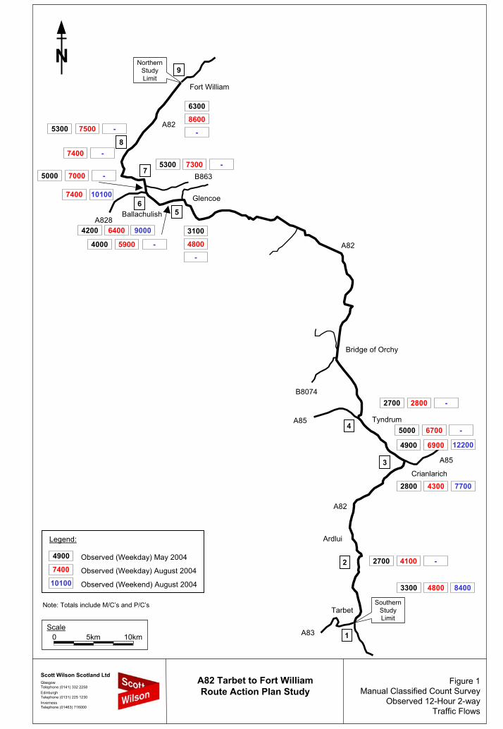
Figure 1Manual Classified Count Survey
Observed 12-Hour 2-wayTraffic Flows
A82 Tarbet to Fort WilliamRoute Action Plan Study
Scott Wilson Scotland LtdGlasgowTelephone (0141) 332 2258EdinburghTelephone (0131) 225 1230InvernessTelephone (01463) 716000
N
Scale0 5km 10km
Tarbet
Ardlui
Crianlarich
SouthernStudyLimit
NorthernStudyLimit
Tyndrum
Bridge of Orchy
Glencoe
Ballachulish
Fort William
A85
A85
A83
A82
B8074
A828
B863
A82
A82
1
2
3
4
56
7
8
9
Legend:
Observed (Weekday) May 2004
Observed (Weekday) August 2004
Observed (Weekend) August 2004
6300
5300
53005000
4200
4000
3100
2700
5000
4900
2800
2700
3300
Note: Totals include M/C’s and P/C’s
75008600
7400
70007300
7400
6400
5900 4800
2800
6700
6900
4300
4100
4800
--
-
--
10100
9000
--
-
-
12200
7700
-
8400
4900
7400
10100
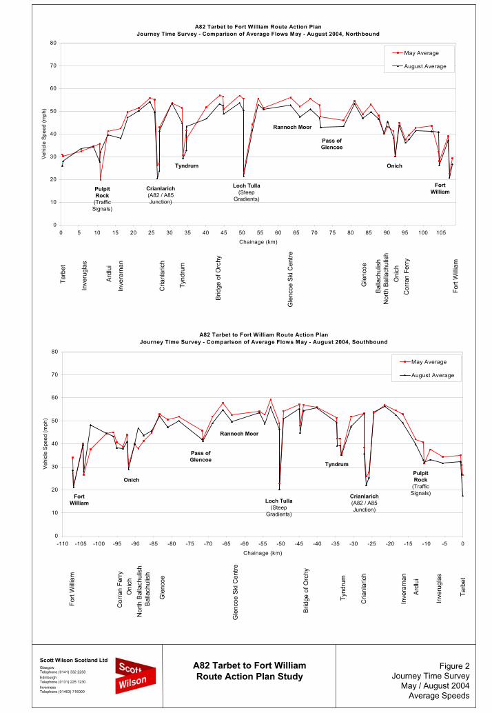
Figure 2Journey Time Survey
May / August 2004 Average Speeds
A82 Tarbet to Fort WilliamRoute Action Plan Study
Scott Wilson Scotland LtdGlasgowTelephone (0141) 332 2258EdinburghTelephone (0131) 225 1230InvernessTelephone (01463) 716000
A82 Tarbet to Fort William Route Action PlanJourney Time Survey - Comparison of Average Flows May - August 2004, Northbound
0
10
20
30
40
50
60
70
80
0 5 10 15 20 25 30 35 40 45 50 55 60 65 70 75 80 85 90 95 100 105
Chainage (km)
Vehi
cle
Spee
d (m
ph)
May Average
August Average
Pulpit Rock
(Traffic Signals)
Crianlarich(A82 / A85 Junction)
Tyndrum
Loch Tulla(Steep
Gradients)
Rannoch Moor
Pass of Glencoe
Onich
Fort William
A82 Tarbet to Fort William Route Action PlanJourney Time Survey - Comparison of Average Flows May - August 2004, Southbound
0
10
20
30
40
50
60
70
80
-110 -105 -100 -95 -90 -85 -80 -75 -70 -65 -60 -55 -50 -45 -40 -35 -30 -25 -20 -15 -10 -5 0
Chainage (km)
Vehi
cle
Spee
d (m
ph)
May Average
August Average
Fort William
OnichPulpit Rock
(Traffic Signals)Crianlarich
(A82 / A85 Junction)
Tyndrum
Loch Tulla(Steep
Gradients)
Rannoch Moor
Pass of Glencoe
Tarb
et
Inve
rugl
as
Ard
lui
Inve
rarn
an
Cria
nlar
ich
Tynd
rum
Brid
ge o
f Orc
hy
Gle
ncoe
Ski
Cen
tre
Gle
ncoe
Bal
lach
ulis
hN
orth
Bal
lach
ulis
hO
nich
Cor
ran
Ferr
y
Fort
Willi
amTa
rbet
Fort
Willi
am
Inve
rugl
as
Ard
lui
Inve
rarn
an
Cria
nlar
ich
Tynd
rum
Brid
ge o
f Orc
hy
Gle
ncoe
Ski
Cen
tre
Gle
ncoe
Bal
lach
ulis
hN
orth
Bal
lach
ulis
hO
nich
Cor
ran
Ferr
y
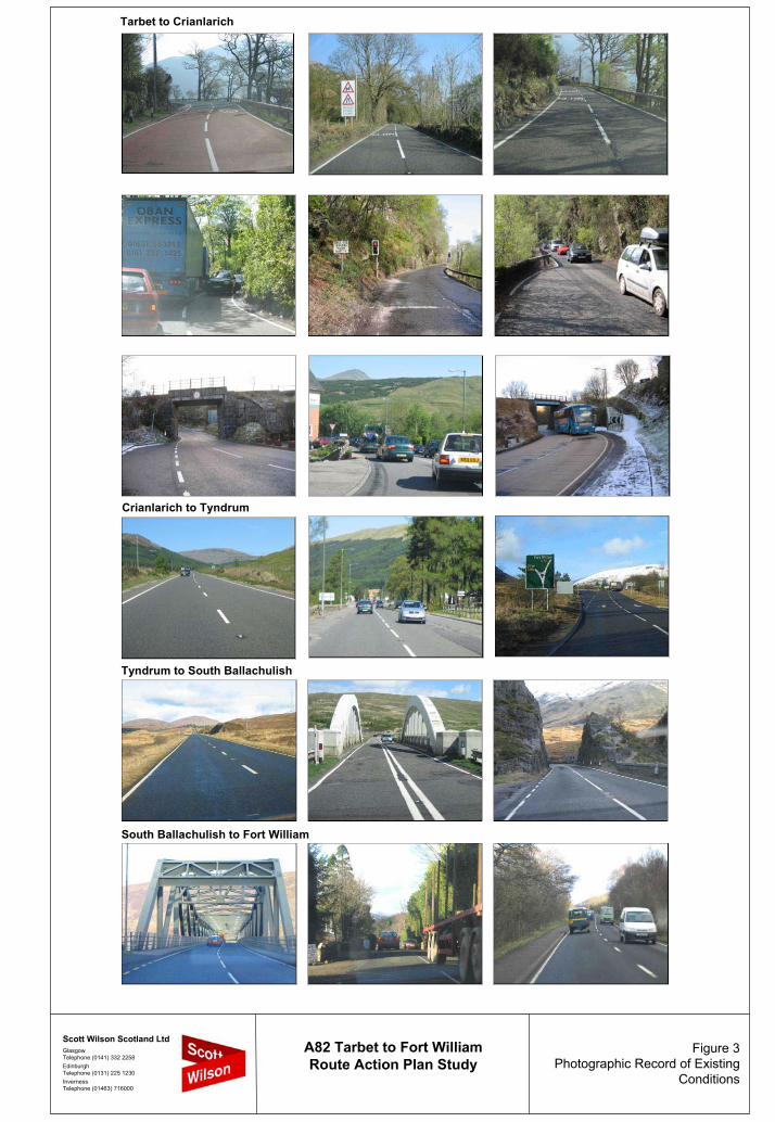
Figure 3Photographic Record of Existing
Conditions
A82 Tarbet to Fort WilliamRoute Action Plan Study
Scott Wilson Scotland LtdGlasgowTelephone (0141) 332 2258EdinburghTelephone (0131) 225 1230InvernessTelephone (01463) 716000
Tarbet to Crianlarich
South Ballachulish to Fort William
Crianlarich to Tyndrum
Tyndrum to South Ballachulish
Transport Scotland A82 Tarbet to Fort William Route Action Plan Study
Executive Summary Page 2 28 February 2006
Based on the results of the data collection surveys, the key operational problems along the A82 are as follows:
• Delays on the Loch Lomond section between Tarbet and Pulpit Rock due to the poor
alignment along the loch, limited overtaking and narrow carriageway width; • Queuing at Pulpit Rock due to shuttle working at the long-term traffic signals; • Delays on the Loch Lomond section between Pulpit Rock and Inverarnan due to the
poor alignment, limited overtaking and narrow carriageway width on some sections; • Queuing in Crianlarich at the A82/A85 priority junction and delays due to the
constrained geometry at the two railway bridges; • Delays at Loch Tulla, north of Bridge of Orchy, due to the steep uphill gradient for
northbound traffic; and • Delays on the Corran Ferry to Fort William section due to the poor alignment along
Loch Linnhe, limited overtaking and narrow carriageway width on some sections. STRATEGY FOR IMPROVEMENT The purpose of the Route Action Plan is to define an overall strategy for improving conditions along the A82 through implementation of various improvements along the route. The strategy considers the following five key areas:
• Carriageway Improvements; • Road Safety; • Localised Carriageway Width Restrictions; • Lay-bys and Rest Areas; and • Pedestrian and Cyclist Facilities. Carriageway Improvements
The following major improvement options, based on the provision of 6.0m, 7.3m or 10.0m wide single carriageways with 1.0m hard strips and 2.5m wide verges, were identified as part of the Route Action Plan, however, it should be noted that some of the options are considered to have a significant impact on the environment which will be assessed at the detailed design stage. Loch Lomond Improvement (6.0m wide single carriageway) The indicative construction cost estimates used as the basis of the economic appraisal of the Loch Lomond carriageway widening improvements equates to £37.5m excluding Optimism Bias (OB), increasing to £54.0m with 44% OB, excluding VAT. Details of the individual scheme are as follows: • Tarbet to Pulpit Rock, 10.3km Const. cost £26.1m (Exc. OB) to £37.5m (44% OB) • Pulpit Rock, 0.4km (tunnel) Const. cost £4.5m (Exc. OB) to £6.5m (44% OB) • Pulpit Rock to Inverarnan, 4.1km Const. cost £6.9m (Exc. OB) to £10.0m (44% OB) • Tarbet to Inverarnan, 14.8km Const. cost £37.5m (Exc. OB) to £54.0m (44% OB) Based on the summation of the combined NESA and QUADRO results, the improvements would provide an approximate NPV of £6.01m, with a corresponding BCR of 1.11.
Transport Scotland A82 Tarbet to Fort William Route Action Plan Study
Executive Summary Page 3 28 February 2006
The above improvements provide a reasonable economic return and address the long term and widely recognised problems of delays along this section of the A82 particularly for tourist traffic during the summer period at the Pulpit Rock traffic signals and for larger vehicles in general due to the constrained road geometry. A detailed environmental assessment of the improvements will be required as the scheme develops. Crianlarich Bypass (7.3m wide single carriageway) The indicative construction cost estimate used as the basis of the economic appraisal of the 1.0km long Crianlarich Bypass equates to £3.1m excluding OB, increasing to £4.4m with 44% OB, excluding VAT. Based on the combined NESA and QUADRO results, the scheme would provide a NPV of -£1.92m, with a corresponding BCR of 0.57. As the do-something model includes a new roundabout between the A82 and A85, the associated road user delay costs at the junction are significant. The results of an alternative layout, based on a priority junction with the A85 forming the minor arm, indicates that the road user benefits would be approximately equal to the scheme cost. Although the above improvement provides a negative economic return, the scheme would address the long term and widely recognised problems of delays at the A82/A85 priority junction particularly for tourist traffic during the summer period and address the road safety issues associated with the carriageway constraints at the railway bridges. Loch Tulla Climbing Lane (10.0m wide single carriageway) The indicative construction cost estimate used as the basis of the economic appraisal of the 3.0km long Loch Tulla Northbound Climbing Lane equates to £10.0m excluding OB, increasing to £14.3m with 44% OB, excluding VAT. Based on the combined NESA and QUADRO results, the scheme would provide a NPV of -£0.01m, with a corresponding BCR of 1.00. A detailed environmental assessment of the improvement will be required as the scheme develops. Corran Ferry to Fort William (Part Only) (7.3m wide single carriageway) The indicative construction cost estimate used as the basis of the economic appraisal of the 4.0km long Corran Ferry to Fort William carriageway improvement equates to £8.5m excluding OB, increasing to £12.2m with 44% OB, excluding VAT. Based on the combined NESA and QUADRO results, the scheme would provide a NPV of £4.06m, with a corresponding BCR of 1.36. Given that the improvement option was limited to the widening of the road to create a standard 7.3m wide carriageway over a 4km length, the economic returns are reasonable and suggest that further improvements to this section may provide further economic benefits.
Transport Scotland A82 Tarbet to Fort William Route Action Plan Study
Executive Summary Page 4 28 February 2006
Overview of Carriageway Improvements
As expected, the combination of low traffic flows, challenging engineering and sensitive environment, especially on the Loch Lomond section, has resulted in a package of improvement options of which only some provide positive returns in terms of transport economic efficiency.
However, it should be noted that a separate study undertaken by Hitrans and issued in September 2005 has indicated that upgrading the A82 route to address the key operational constraints could generate significant wider economic benefits. The report concluded that under the full investment scenario, the central forecast for additional income in Scotland over a 10 year period would equate to £313m (discounted). Under the moderate investment scenario, the additional income would reduce to £50m. It should also be recognised that improving the Tarbet to Inverarnan section of the A82 could result in commercial vehicles, which it has been suggested presently use alternative and longer routes to avoid the potential delays on the A82, reassigning back to the A82. It is also possible that the impact of accidents due, at least in part, to the narrow carriageway between Tarbet and Inverarnan, generates delays which have not been quantified as part of the economic assessment but nevertheless can represent a significant cost to road users. Based on this, the total economic benefits associated with some of the improvement options could exceed the reported level of benefits. On the southern section of the route along Loch Lomond, consideration has been given to the standard of carriageway required taking into account current traffic volumes, the forecast in traffic growth, the potential effects of strategic traffic reassignment, and the sensitive environment. It is intended that the information contained in the project report will provide a reasonable basis to inform the debate on the provision of either a 6.0m or 7.3m wide carriageway taking into account the capital cost, the road user benefits and the impact on the environment. Road Safety As part of the Route Action Plan, an analysis of recent road traffic accident trends and characteristics was undertaken. This analysis led to the identification of accident clusters and the consideration of accident remedial measures. In total, some 14 accident clusters were identified along the A82 between Tarbet and Fort William. The Route Action Plan includes the provision of localised low cost measures, such as additional signing, improved road markings, anti-skid surfacing, hatched ladder markings and junction bollards, and more significant improvements such as better surface drainage, localised carriageway widening and junction improvements to address prevailing road traffic accident issues and to contribute positively to road safety. These initial options should be developed in consultation with the various AIP teams. Localised Carriageway Width Restrictions Examination of the A82 confirms that some sections of the road are relatively narrow, particularly on the southern section between Tarbet and Pulpit Rock. In addition, a number of localised ‘pinch points’ have been identified, typically at bridges, where the width of the carriageway reduces significantly.
Transport Scotland A82 Tarbet to Fort William Route Action Plan Study
Executive Summary Page 5 28 February 2006
Some 25 locations, mainly located between Tarbet and Inverarnan and through Rannoch Moor and Glencoe, have been identified where the width of the carriageway reduces significantly. The analysis of accident records at these points for the last 5-year period indicates that the accidents at 15 of these locations could be attributed to the narrow carriageway. The Route Action Plan therefore includes a programme of improvements to widen the carriageway at these locations. Lay-bys and Rest Areas The A82 route attracts a high volume of tourists, particularly during the summer months and experiences one of the highest seasonal variations in traffic flows on the Scottish trunk road network. As part of the Route Action Plan, an examination of the lay-bys and rest areas along the A82 route was undertaken to consider the requirements for providing suitable lay-bys and rest areas/picnic sites along the route. The Route Action Plan therefore includes a programme to rationalise the intervals between lay-bys to between 5km and 8km, and to provide some 6 additional picnic sites along the route to supplement the existing sites at Tarbet, Inveruglas and on Loch Linnhe. Pedestrian and Cyclist Facilities Currently the facilities for pedestrians and cyclists who wish to use the A82 are limited. With the exception of short sections of footpath at Tarbet, Sloy Power Station, Crianlarich, Tyndrum, Glencoe village, Ballachulish Bridge, Onich, Corran Ferry and Fort William, the majority of the route has no dedicated facilities for pedestrians or cyclists despite being a popular tourist and recreational route and the close proximity of the West Highland Way. Although no pedestrian or cyclist related accidents have occurred at the points of interface between the A82 and the West Highland Way, some 15 accidents involving pedestrians and cyclists occurred along the route during the last 5 years. The majority of these accidents were caused by vehicles colliding with pedestrians at the roadside, and consequently the provision of improved facilities should be considered as part of the improvement options to provide a safer route for all road users including pedestrians and cyclists. RECOMMENDED IMPLEMENTATION STRATEGY The overall strategy for improving conditions along the A82 includes a programme of schemes over the short, medium and long term. The strategy includes improvements to address road safety, carriageway width restrictions, the provision of lay-bys and rest areas, facilities for pedestrians and cyclists, and carriageway improvements.
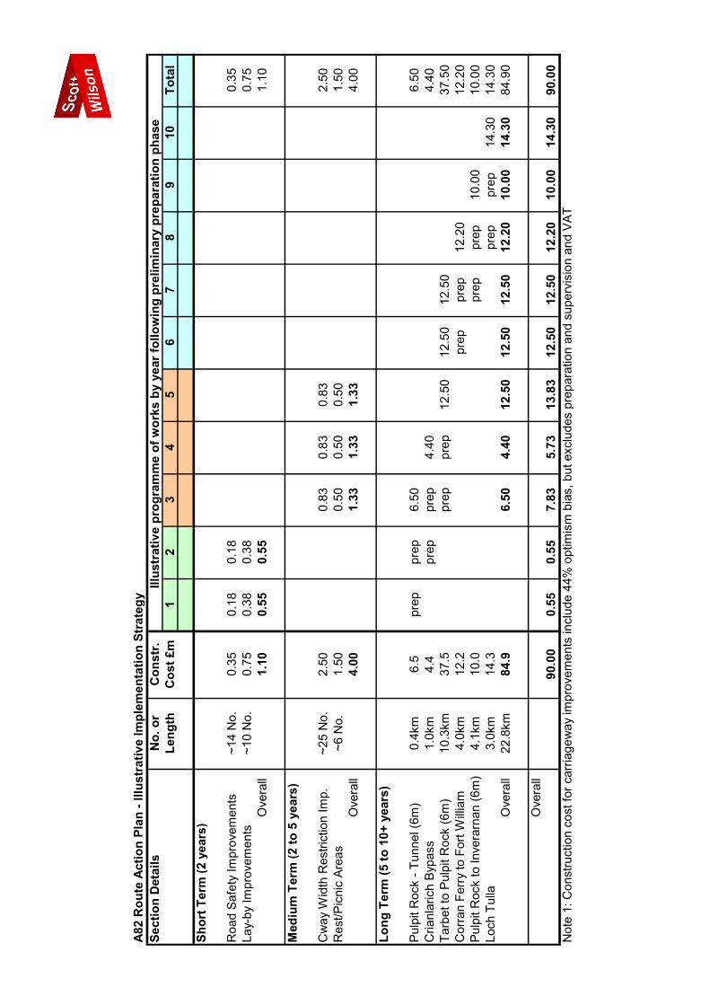
The short term measures include the following localised improvements that should be capable of implementation within a 2 year time frame.
• A programme of some 14 road safety / accident remedial measure schemes; and • A programme of improvements for some 10 lay-bys. The total cost estimated for the above measures is £1.1m. The medium term measures include the following localised improvements that should be capable of implementation within a 2 to 5 year time frame.
Transport Scotland A82 Tarbet to Fort William Route Action Plan Study
Executive Summary Page 6 28 February 2006
• A programme of improvements for some 6 new rest/picnic areas; • A programme of improvements to address some 25 carriageway width restrictions
including widening of narrow structures; and • A programme of improvements for pedestrians and cyclists, although these facilities
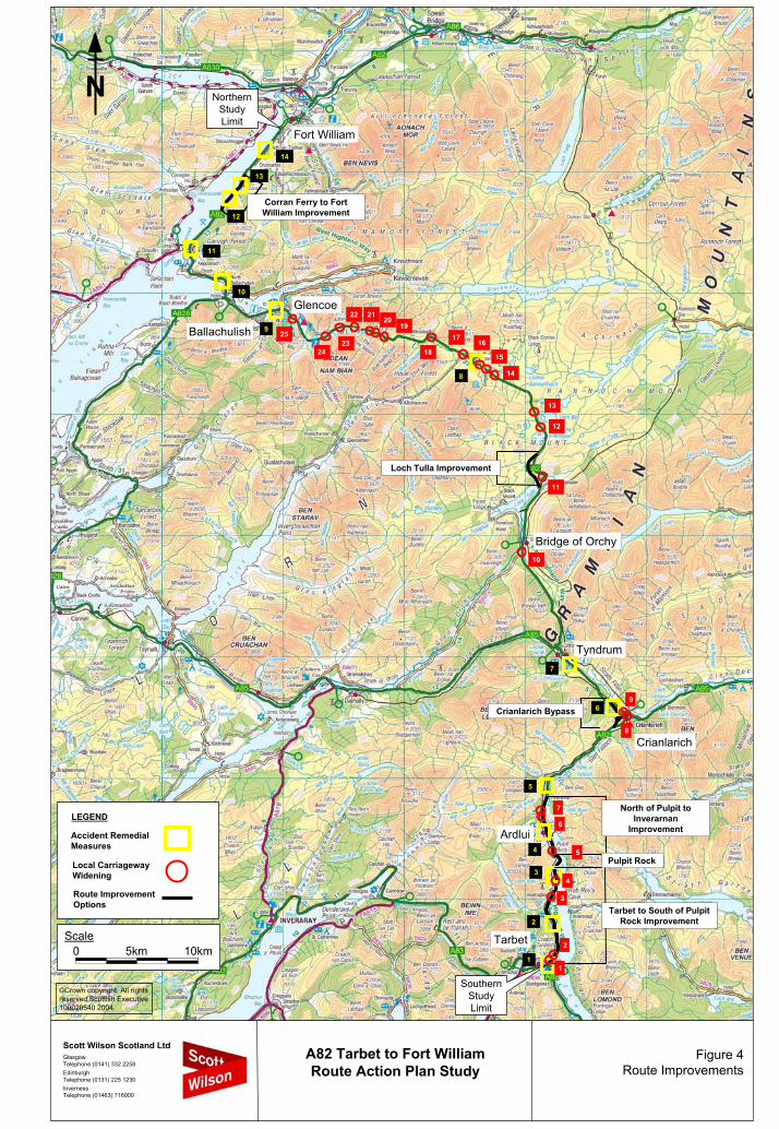
could be incorporated into the carriageway improvements. The total cost estimated for the above measures is £4.0m. The long term measures include the following schemes, such as bypasses, climbing lanes, and carriageway improvements, that should be capable of implementation within a 5 to 10+ year time frame. • Tarbet to Pulpit Rock, 10.3km Const. cost £26.1m (Exc. OB) to £37.5m (44% OB) • Pulpit Rock, 0.4km (tunnel) Const. cost £4.5m (Exc. OB) to £6.5m (44% OB) • Pulpit Rock to Inverarnan, 4.1km Const. cost £6.9m (Exc. OB) to £10.0m (44% OB) • Crianlarich Bypass, 1km Const. cost £3.1m (Exc. OB) to £4.4m (44% OB) • Loch Tulla Climbing Lane, 3km Const. cost £10.0m (Exc. OB) to £14.3m (44% OB) • Corran Ferry to Fort William 4km Const. cost £8.5m (Exc. OB) to £12.2m (44% OB) The total indicative construction cost estimates used as the basis of the economic appraisals of the 22.8km improvements equates to £59.1m excluding Optimism Bias (OB), increasing to £84.9m with 44% OB, excluding VAT. In accordance with the standard procedures defined in the Design Manual for Roads and Bridges, the costs for the preparation and supervision of the above schemes based on 12% and 5% respectively equates to an additional £14.4m on the £84.9m total cost estimate, which results in a total scheme cost of £99.3m for the major schemes that form the basis of the Route Action Plan. The overall NPV of the carriageway improvements is £8.1m, with a corresponding BCR of 1.09 based on the application of 44% optimism bias. As a sensitivity test, the NPV for the same package of improvements based on 25% optimism bias is £19.9m, with a corresponding BCR of 1.27. The general locations of the A82 improvement schemes are shown in Figure 4, with an overall assessment of the long term measures, including the environmental, safety and economic effects, shown in the Tables overleaf. As part of the detailed implementation strategy for the 5 to 10+ year period, schemes that maximise economic returns or address key operational problems along the route, such as road user delays and journey time reliability and therefore deliver significant benefits to the road users, should be brought forward more rapidly within the long term programme. An illustrative implementation strategy is shown overleaf to indicate a possible programme for delivering the key components of the Route Action Plan, including details of the short, medium and long-term measures.
N
©Crown copyright. All rights reserved Scottish Executive 100020540 2004.
Scale0 5km 10km
Tarbet
Crianlarich
SouthernStudyLimit
NorthernStudyLimit
Tyndrum
Bridge of Orchy
Glencoe
Ballachulish
Fort William
Crianlarich Bypass
Loch Tulla Improvement
Corran Ferry to Fort William Improvement
4
Ardlui
1
2
3
5
6
8
9
7
10
11
12
13
14
Route Improvement Options
Local CarriagewayWidening
LEGEND
Accident RemedialMeasures
Pulpit Rock
Tarbet to South of Pulpit Rock Improvement
North of Pulpit to Inverarnan
Improvement
1
2
3
4
5
6
7
8
9
10
11
12
13
14
15
1617
2019
18
2122
2324
25
Figure 4Route Improvements
A82 Tarbet to Fort WilliamRoute Action Plan Study
Scott Wilson Scotland LtdGlasgowTelephone (0141) 332 2258EdinburghTelephone (0131) 225 1230InvernessTelephone (01463) 716000
Transport Scotland A82 Tarbet to Fort William Route Action Plan Study
Executive Summary Page 7 28 February 2006
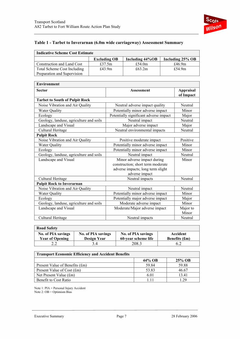
Table 1 - Tarbet to Inverarnan (6.0m wide carriageway) Assessment Summary
Indicative Scheme Cost Estimate Excluding OB Including 44%OB Including 25% OB Construction and Land Cost £37.5m £54.0m £46.9m Total Scheme Cost Including Preparation and Supervision
£43.9m
£63.2m
£54.9m
Environment Sector Assessment Appraisal
of Impact Tarbet to South of Pulpit Rock Noise Vibration and Air Quality Neutral adverse impact quality Neutral Water Quality Potentially minor adverse impact Minor Ecology Potentially significant adverse impact Major Geology, landuse, agriculture and soils Neutral impact Neutral Landscape and Visual Major adverse impact Major Cultural Heritage Neutral environmental impacts Neutral Pulpit Rock Noise Vibration and Air Quality Positive moderate impact Positive Water Quality Potentially minor adverse impact Minor Ecology Potentially minor adverse impact Minor Geology, landuse, agriculture and soils Neutral impact Neutral Landscape and Visual Minor adverse impact during
construction; short term moderate adverse impacts; long term slight
adverse impact
Minor
Cultural Heritage Neutral impacts Neutral Pulpit Rock to Inverarnan Noise Vibration and Air Quality Neutral impact Neutral Water Quality Potentially minor adverse impact Minor Ecology Potentially major adverse impact Major Geology, landuse, agriculture and soils Moderate adverse impact Minor Landscape and Visual Moderate/Major adverse impact Major to
Minor Cultural Heritage Neutral impacts Neutral
Road Safety No. of PIA savings Year of Opening
No. of PIA savings Design Year
No. of PIA savings 60-year scheme life
Accident Benefits (£m)
2.2 3.4 208.3 6.2
Transport Economic Efficiency and Accident Benefits 44% OB 25% OB Present Value of Benefits (£m) 59.84 59.88 Present Value of Cost (£m) 53.83 46.67 Net Present Value (£m) 6.01 13.41 Benefit to Cost Ratio 1.11 1.29
Note 1: PIA = Personal Injury Accident Note 2: OB = Optimism Bias

Transport Scotland A82 Tarbet to Fort William Route Action Plan Study
Executive Summary Page 8 28 February 2006
Table 2 - Crianlarich Bypass Assessment Summary
Indicative Scheme Cost Estimate Excluding OB Including 44%OB Including 25% OB Construction and Land Cost £3.1m £4.4m £3.8m Total Scheme Cost Including Preparation and Supervision
£3.6m
£5.1m
£4.4m
Environment Sector Assessment Appraisal
of Impact Noise Vibration and Air Quality Neutral impact Neutral Water Quality Potentially neutral adverse impact Neutral Ecology Potentially minor adverse impact Minor Geology, landuse, agriculture and soils Minor adverse impact Minor Landscape and Visual Minor adverse impacts Minor Cultural Heritage Neutral impacts Neutral
Road Safety No. of PIA savings Year of Opening
No. of PIA savings Design Year
No. of PIA savings 60-year scheme life
Accident Benefits (£m)
0.5 0.5 32.7 0.45
Transport Economic Efficiency and Accident Benefits 44% OB 25% OB Present Value of Benefits (£m) 2.59 2.59 Present Value of Cost (£m) 4.51 3.89 Net Present Value (£m) -1.92 -1.30 Benefit to Cost Ratio 0.57 0.67
Note 1: PIA = Personal Injury Accident Note 2: OB = Optimism Bias
Transport Scotland A82 Tarbet to Fort William Route Action Plan Study
Executive Summary Page 9 28 February 2006
Table 3 - Loch Tulla Climbing Lane Assessment Summary
Indicative Scheme Cost Estimate Excluding OB Including 44%OB Including 25% OB Construction and Land Cost £10.0m £14.3m £12.5m Total Scheme Cost Including Preparation and Supervision
£11.7m
£16.7m
£14.6m
Environment Sector Assessment Appraisal
of Impact Noise Vibration and Air Quality Positive moderate impact Minor Water Quality Potentially moderate adverse impact Minor Ecology Potentially moderate adverse impact Minor Landscape and Visual Significant adverse impact Major Cultural Heritage Neutral impact Neutral
Road Safety No. of PIA savings Year of Opening
No. of PIA savings Design Year
No. of PIA savings 60-year scheme life
Accident Benefits (£m)
0.8 0.8 45.5 3.20
Transport Economic Efficiency and Accident Benefits 44% OB 25% OB Present Value of Benefits (£m) 16.00 16.00 Present Value of Cost (£m) 16.01 14.04 Net Present Value (£m) -0.01 1.96 Benefit to Cost Ratio 1.00 1.14
Note 1: PIA = Personal Injury Accident Note 2: OB = Optimism Bias
Transport Scotland A82 Tarbet to Fort William Route Action Plan Study
Executive Summary Page 10 28 February 2006
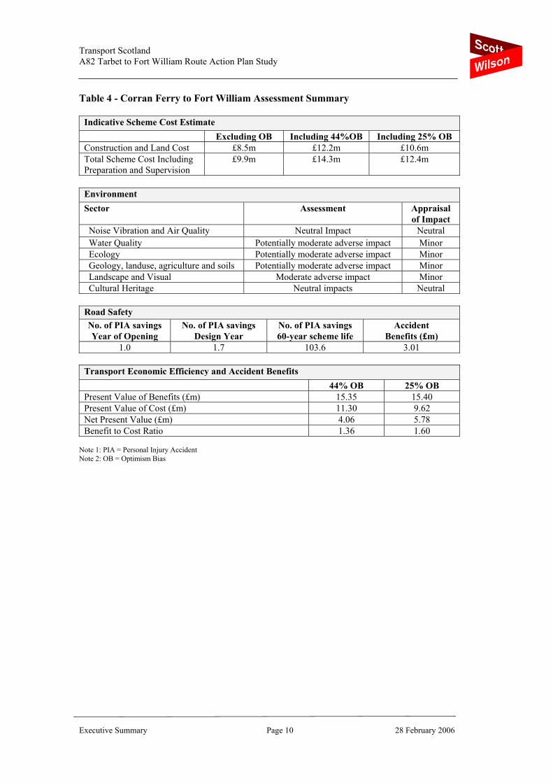
Table 4 - Corran Ferry to Fort William Assessment Summary
Indicative Scheme Cost Estimate Excluding OB Including 44%OB Including 25% OB Construction and Land Cost £8.5m £12.2m £10.6m Total Scheme Cost Including Preparation and Supervision
£9.9m
£14.3m
£12.4m
Environment Sector Assessment Appraisal
of Impact Noise Vibration and Air Quality Neutral Impact Neutral Water Quality Potentially moderate adverse impact Minor Ecology Potentially moderate adverse impact Minor Geology, landuse, agriculture and soils Potentially moderate adverse impact Minor Landscape and Visual Moderate adverse impact Minor Cultural Heritage Neutral impacts Neutral
Road Safety No. of PIA savings Year of Opening
No. of PIA savings Design Year
No. of PIA savings 60-year scheme life
Accident Benefits (£m)
1.0 1.7 103.6 3.01
Transport Economic Efficiency and Accident Benefits 44% OB 25% OB Present Value of Benefits (£m) 15.35 15.40 Present Value of Cost (£m) 11.30 9.62 Net Present Value (£m) 4.06 5.78 Benefit to Cost Ratio 1.36 1.60
Note 1: PIA = Personal Injury Accident Note 2: OB = Optimism Bias
A8
2 R
oute
Act
ion
Plan
- Ill
ustr
ativ
e Im
plem
enta
tion
Stra
tegy
Sect
ion
Det
ails
No.
or
Con
str.
Illus
trat
ive
prog
ram
me
of w
orks
by
year
follo
win
g pr
elim
inar
y pr
epar
atio
n ph
ase
Leng
thC
ost £
m1
23
45
67
89
10To
tal
Shor
t Ter
m (2
yea
rs)
Roa
d Sa
fety
Impr
ovem
ents
~14
No.
0.35
0.18
0.18
0.35
Lay-
by Im
prov
emen
ts~1
0 N
o.0.
750.
380.
380.
75O
vera
ll
1.10
0.55
0.55
1.10
Med
ium
Ter
m (2
to 5
yea
rs)
Cw
ay W
idth
Res
trict
ion
Imp.
~25
No.
2.50
0.83
0.83
0.83
2.50
Res
t/Pic
nic
Area
s ~6
No.
1.50
0.50
0.50
0.50
1.50
Ove
rall
4.
001.
331.
331.
334.
00
Long
Ter
m (5
to 1
0+ y
ears
)
Pul
pit R
ock
- Tun
nel (
6m)
0.4k
m6.
5pr
eppr
ep6.
506.
50C
rianl
aric
h By
pass
1.0k
m4.
4pr
eppr
ep4.
404.
40Ta
rbet
to P
ulpi
t Roc
k (6
m)
10.3
km37
.5pr
eppr
ep12
.50
12.5
012
.50
37.5
0C
orra
n Fe
rry
to F
ort W
illiam
4.0k
m12
.2pr
eppr
ep12
.20
12.2
0P
ulpi
t Roc
k to
Inve
rarn
an (6
m)
4.1k
m10
.0pr
eppr
ep10
.00
10.0
0Lo
ch T
ulla
3.0k
m14
.3pr
eppr
ep14
.30
14.3
0O
vera
ll
22.8
km84
.96.
504.
4012
.50
12.5
012
.50
12.2
010
.00
14.3
084
.90
Ove
rall
90
.00
0.55
0.55
7.83
5.73
13.8
312
.50
12.5
012
.20
10.0
014
.30
90.0
0N
ote
1: C
onst
ruct
ion
cost
for c
arria
gew
ay im
prov
emen
ts in
clud
e 44
% o
ptim
ism
bia
s, b
ut e
xclu
des
prep
arat
ion
and
supe
rvis
ion
and
VAT
Scott Wilson Scotland Ltd 6 Park Circus Glasgow G3 6AX UK Phone +44 (0)141 332 2258 Fax +44 (0)141 333 9360
23 Chester Street Edinburgh EH3 7ET UK Phone +44 (0)131 225 1230 Fax +44 (0)131 225 5582 6 Ardross Street Inverness IV3 5NN UK Phone +44 (0)1463 716000 Fax +44 (0)1463 714639 Scott Wilson Scottish Provident House 31 — 33 Mosley Street Newcastle upon Tyne NE1 1YF UK Phone +44 (0)191 255 8080 Fax +44 (0)191 255 8081