A487 LLANWNDA TO SOUTH OF LLANLL YFNI IMPROVEMENT · A487 LLANWNDA TO SOUTH OF LLANLL YFNI...
9
)_ 7/ A487 LLANWNDA TO SOUTH OF LLANLLYFNI IMPROVEMENT ONLINE CORRIDOR OPTION ARCHAEOLOGICAL ASSESSMENT Report No. 271 Y mddiriedolaeth Archaeolego1 Gwynedd Gwynedd Archaeological Trust
Transcript of A487 LLANWNDA TO SOUTH OF LLANLL YFNI IMPROVEMENT · A487 LLANWNDA TO SOUTH OF LLANLL YFNI...

)_ 7/
A487 LLANWNDA TO SOUTH OF
LLANLL YFNI IMPROVEMENT
ONLINE CORRIDOR OPTION
ARCHAEOLOGICAL ASSESSMENT
Report No. 271
Y mddiriedolaeth Archaeolego1 Gwynedd
Gwynedd Archaeological Trust
A487 LLANWNDA TO SOUTH OF
LLANLL YFNI IMPROVEMENT
ONLINE CORRIDOR OPTION
ARCHAEOLOGICAL ASSESSMENT
Prepared for Gwynedd Council
Gwynedd Archaeological Trust Report No. 271
A487 LLANWNDA TO SOUTH OF LLANLLYFNl IMPROVEMENT
ARCHAEOLOGICAL ASSESSMENT
ONLINE CORRIDOR OPTION
1.0 INTRODUCTION
This report contains the results of an archaeological assessment carried out on the .. Online Corridor Option .. of the proposed A487 improvement from Llanwnda to south of LlanJlyfni. An archaeologtcal assessment has already been carried out for the published route (GAT Report No 75). and the alignment of the alternative route differs only bet\>'een Llanwnda and Groeslon. Therefore only sites affected by this option arc included in this report. If the impact upon a site previously catalogued has changed then this will also be noted.
2.0 METHODOLOGY
An assessment has been carried out consisting of a desk-top study and observation in the field . Information has been collated from the Gwynedd Sites and Monuments Record. archi,·e records held by the Gwynedd Arcruve Service and the University of Wales. Bangor. Although there are no known sites of signiJicance on this route. a fuJI evaluation bas not been carried out. and tJ1e lack of known sites should not be taken to mean that no archaeolog_' \\ill be affected.
3.0 RESULTS
3.1 Introduction
This "Online Corridor Option" leaves the proposed route at the roundabout in Llanwnda at SH~ 7595819. II runs along the east side of the existing A487 for about a quarter of a mile and then veers slightly east at SH4 7625 789 to by-pass Dolydd It rejoinc; the existing A-187 at Bodarfryn at SH~7525678 and continues along the M87 until it rejoins the pre\iousl) proposed route just south west of Llwyn y gwalch at SH-!737563-J.
J. 2 Site Gazetteer
This section describes tJ10se sites identified during the desk-based study as being on or close to the line of the proposed corridor option. To avoid confusion numbers correspond to those used in tJ1e original archaeological assessment where appropriate and continue from nwnber 51 for ne">vly identified features. Features are described as they occur from north to south.
51. Track to Cefo Bendre SH.J762576l Category D impact: Constderable This farm and its track are present on the 18~0 tithe map of Llammda. The road would destroy a section of the fann track. The track has vegetated stone banks on both sides with some large boulders to the north. A slate-lined channel with a slate lintel runs tluough the bank on the south side. The surface is tarmac with a central grassy strip. Recommendation for further assessment: None Recommendrrtionfor mitigatory measures: Basic recording during a watching brief
52. Track to Traian SH476257.J3 Category: D impact: Considerable This farm and its track are present on the 18-tO tithe map ofLlanwnda. The track. at the point the new road will cross it. has a low stone wall on tlte north side and a wire fence to the south. The surface is tannac with a centrdl grassy strip. The original main road at this point followed the western end of the track and then turned south along the eastern boundary of the land adjoining the Old Smithy (XD2NIM9). The line of this road is no longer visible on the ground but may be revealed during construction work. Recommendation for further assessment: None Recommendation for mitigatory measures:. Basic recording during a watching brief
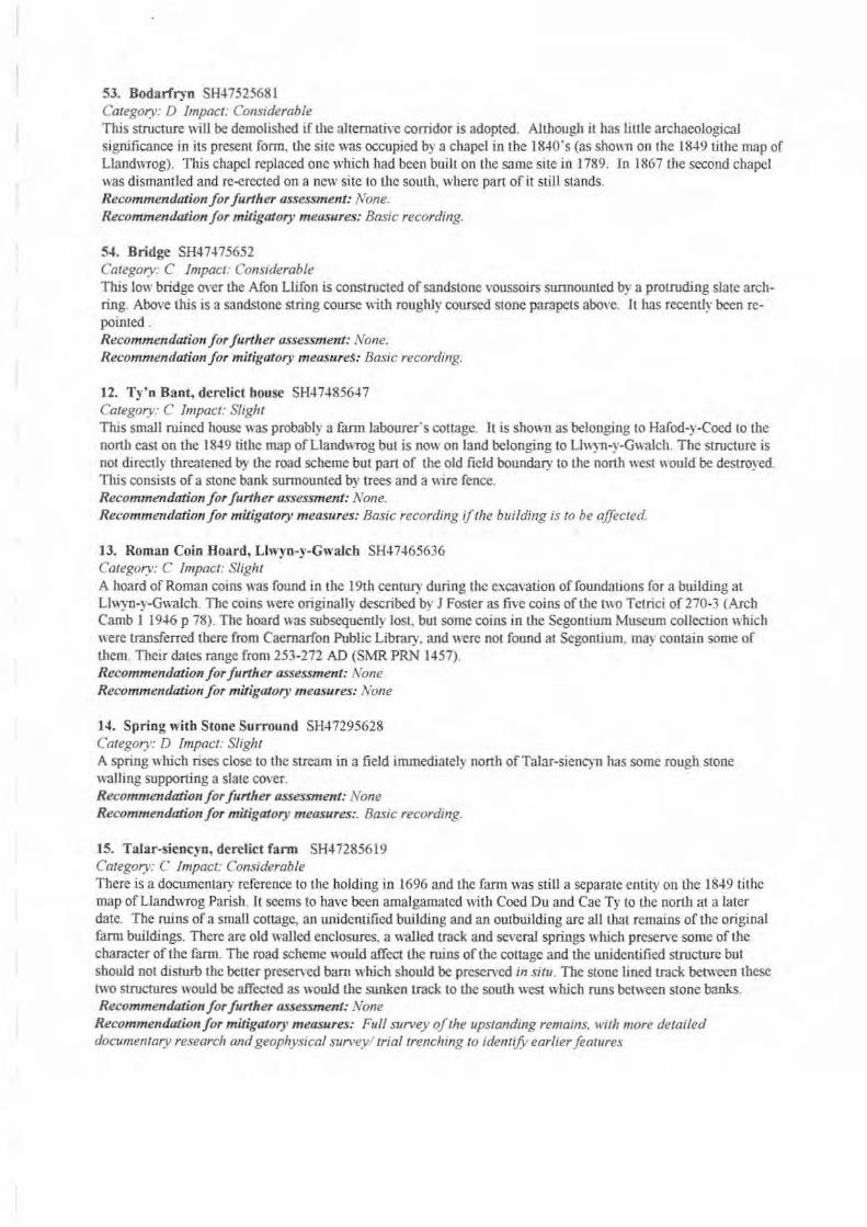
53. Bodariryn SH-l75256tH Category: D impact: Cons1derable This structure will be demolished iftl1e alternative corridor is adopted. Although it has tittle archaeological significance in its present form, tl1e site was occupied by a chapel in the 18-to·s (as sh0\111 on the 18~9 tithe map of Llandwrog). This chapel replaced one which had been built on the same site in 1789. In 186 7 the second chapel was dismantled and rco{!rected on a new site to the soutJ1, where part ofit still stands. Recommendatio11 for further assessment: None. Recommendation for mitigatory measures: Bas1c recording.
54. Bridge SH47-l75652 Category: C Impact: Considerable This low bridge over the Afon Llifon is constructed of sandstone voussoirs sunnounted by a protruding slate archring. Above this is a sandstone string course with roughly coursed stone parapets abo,·e. It has recently been repainted. Recommendation for further assessment: None. Recommendation for mitigatory measure$: Basic recording.
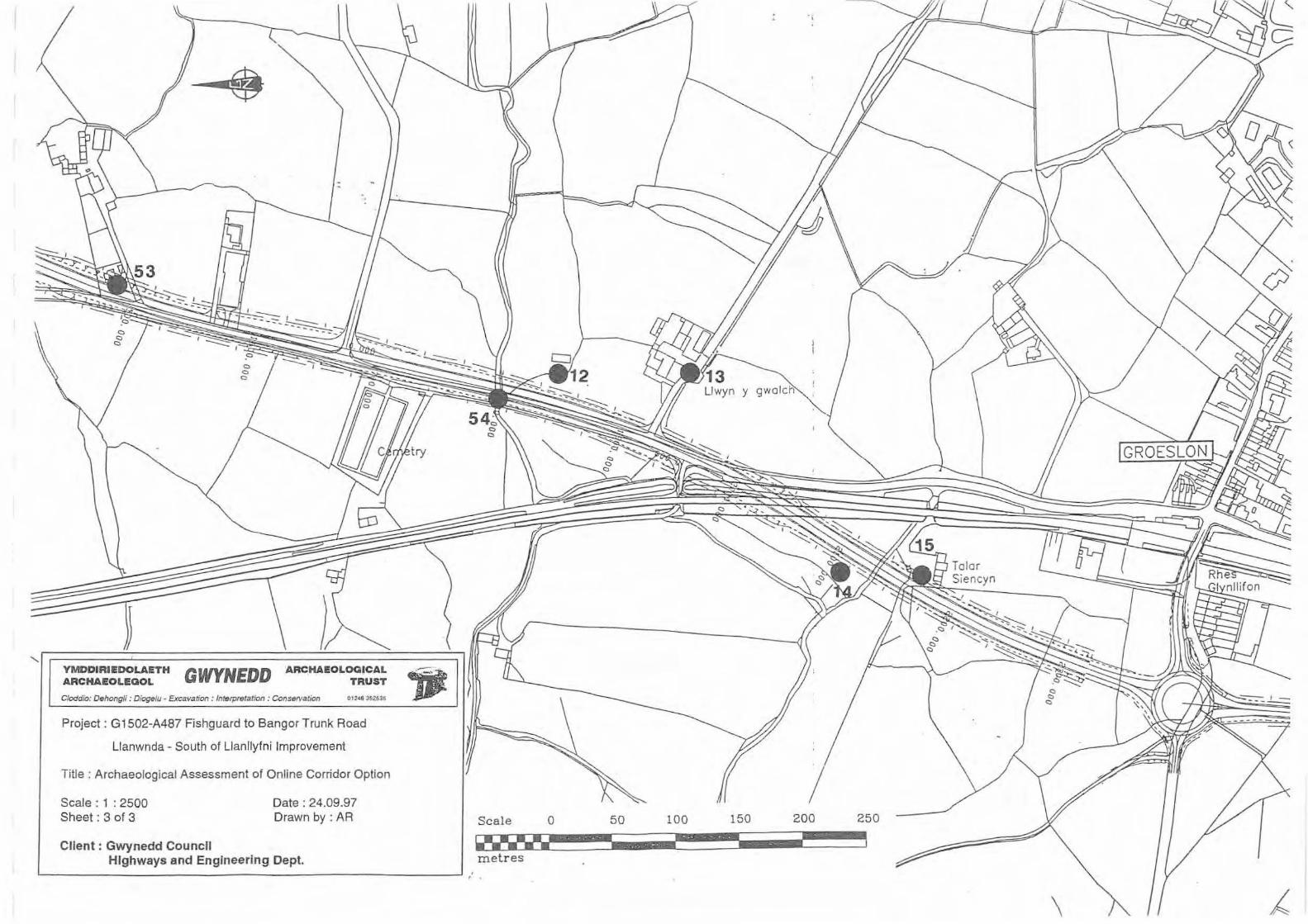
12. Ty'n Bant, derelict bouse SH-t748564 7 Category: C Impact: Slight This smaJJ ruined house ''as probably a farm labourer's cottage. It is shown as belonging to Hafod-y-Coed to the north east on the 1849 titl1e map ofLlandwrog but is DO\\ on land belonging 10 Llwyn-y-GwaJch. The structure is not directly tllfeatened by the road scheme but part of tlte old field boundary to the north ''est \\Ould be destroyed This consisrs of a stone bank surmounted by trees and a "ire fence. Recommendation f or further assessment: None. Recommendation for mitigatory measures: Basic recording i/fhe building is fo be affected
13. Roman Colo Hoard, Llwyn-y-GwaJcb SH.J7-l65636 Category: C Impact: Slight A hoard of Roman coins was found in the 19th century during the e:xcayation of foundations for a building at Llwyn-y-GwaJch. The coins were originally described b · J Foster as five coins of the two Tetrici of 270-3 (Arch Camb I 19-M p 78). The board \\as subsequentl} losL but some coins in the Segootium Museum collection \\hich were transferred there from Caernarfon Public Library. and were not found at Segontium. rna~ contain some of them. Their dates range from 253-272 AD (SMR PRN 1457). Recommendation for furtlrer assessment: None Recommendation for mitigatory measures: None
14. Spring witb Stone Surround SH47295628 Category: D Impact: Slight A spring which rises close to the stream in a field immediately north ofTalar-siencyn has some rough stone walling supporting a slate cover. Recommendation for further assessment: None Recommendation for mitigatory measures:. Basic recordmg.
15. Talar-siencyn, derelict farm SH47285619 Category: C Impact: Cons1derable There is a documentary reference to the holding in 1696 and the farm was still a separate entity on the 1849 tithe map ofLiandwrog Parish . It seems to have been amalgamated with Coed Du and Cae Ty to the north at a later date. The ruins of a smaJI cottage, an unidentified building and an outbuilding are all that remains of the original farm buildings. There are old waJied enclosures, a walled track and severaJ springs which preserve some of the character of the farm. The road scheme would affect the ruins of the cottage and the unidentified structure but should not disturb the better presen·ed barn which should be preserved in situ. The stone lined track between these two structures would be affected as would the sunken track to the south west which runs between stone banks. Recommendation for further assessment: None
Recommendation for mitigatory measures: Full survey of the upstanding remains. w1th more detailed documentary research and geophysical survey! trial trenclung ro identify earlier features
4.0 SUMMARY
A desk-top study has been carried out on the "Online Corridor Option'' followed a Limited field research. This has identified a number of sites which will be affected by the alternative route but none are of high archaeological significance. The only site requiring further investigation prior to construction work would be the features at Tai:-Jrsiencyn. Current evidence would suggest that there is not a significant difference between the two routes of the impact upon the archaeology.
5.0 BIDLIOGRAPHY
Aerial photographs held by the Countryside Council for Wales Aerial photographs held by Gwynedd County Council Bassett, T M. and Davies, B. L., 1977 Atlas ofCaernarvonshire Baughan, Peter E, 1991 A Regional History of the Railways of Great Britain, Vol. ll North Boyd,J. I. C., 1981 Narrow Gouge Railways in North Caemarvonshire Vol. 1 The West
and Mid Wales. Cadw: Welsh Historic Monuments Listed buildings information Davies. Dewi Welsh place-names and their meanings Davies. Elwyn (ed.). 1975 A Gazelfeer of Welsh Place-names Department of Transport eta/., 1993 Design Afanual.for Roads and Bridges. Vol. 11
Envirorunemal Assessment Dodd.. A. H., 1968 History ofCaernarvonshire Estate maps and papers held at UCNW Archives. Bangor, and the county archives. CaemarfonGwynedd Sites and Monuments Record Hall, E. H. (ed. Jones, E. G .. l952) A Description ofCaemarvonshire (1809-1811) Hughes. S . 1990 The Brecon Fores1 Tramroads Lewis. S .. 1833 Topographical Dictionary of Wales Ordnance Survey maps: 2" manuscript for first 1" edition, 1819
1" first edition, 1823. re>ised 1836 1:10,560 1963 l: 10,000 1975 1:2,500 1889. 1908. 1918
Pierce. T. Jones. 1972 Medieval Welsh Society Plans at 1:2,500 provided by Gwynedd County Council Richards. A. J., 1991 A Gazeteer of the 11-'elsh Slate Industry Royal Commission on Ancient and Historical Monuments in Wales. 1960 fm-·entOJy. Central Trinder. Barrie, 1982 The A-faking of the Industrial Landscape
Caemarvonshire Vol II

I y Ga rth
Scale 0 50 100 150 200 250
~~~-~~-~}·~~-~........ ........ . ....... ~ ... JI ••**•• l•••• I metres
YMDDIRIEDOLAETH ARCHAEOLEGOL GWYNEDD ARCHAEOLOGICAL
TRUST
C/oddio: Dehongli: Dioge/u- Excavation · Interpretation : Conservation 01248 352535
Project: G1502-A487 Fishguard to Bangor Trunk Road
Llanwnda - South of Llanllyfni Improvement
Title : Archaeological Assessment of Online Corridor Option
Scale : 1 : 2500 Sheet: 1 of 3
Client : Gwynedd Council
Date : 24.09.97 Drawn by: AR
Highways and Engineering Dept.

_, __ , l_C?_ 1. _y_ _y_ _y: _y_
YMDDIRIEDOLAETH ARCHAEOLEGOL GWYNEDD ARCHAEOLOGICAL
TRUST
C/oddio: Dehongli: Diogelu- Excavation : lnterpretatton : ConseNation 01248 352535
Project: G1502-A487 Fishguard to Bangor Trunk Road
Llanwnda - South of Llanllyfni Improvement
Title : Archaeolog ical Assessment of Online Corridor Option
Scale : 1 : 2500 Sheet: 2 of 3
Client : Gwynedd Council
Date : 24.09.97 Drawn by : AR
Highways and Engineering Dept.
Scale 0
... ~r• • ~~-~
metres
50
& we
100 150 200 250
F 1
YMDDIRII!DOLAETH ARCHAEOLEGOL GWYNEDD ARCHAEOLc;;:~:~
C/oddio: Dehong/i: Dioge/u • Excava~·on :Interpretation : Conservation 01 248 352535
Project: G1502-A487 Fishguard to Bangor Trunk Road
Llanwnda - South of Llanllyfni Improvement
Title : Archaeological Assessment of Online Corridor Option
Scale : 1 : 2500 Sheet: 3 of 3
Client: Gwynedd Council
Date: 24.09.97 Drawn by: AR
Highways and Engineering Dept. ~------------------------------------------------------~ :
Scale 0 50 100 150 250
metres
\

YMDDIRIEDOLt\ETH ARCHAEOLEGOL GWYNEDD ARCIIt\EOLOGICAL TRUST
Cruig Ocuun- Frnrdd y Cinrth - llangor- (iwyncdll- LLS72RT. Phon~ (0 124!!) 352535: rl:lcs/F:n (01248) 370925