
A Visionary Study on Urban Neighborhood Models in Kabul ...
28
A Visionary Study on Urban Neighborhood Models in Kabul City Based on Actual Surveys Sofia Sahab PhD student, Assist. Lect. Nagoya Institute of Technology, Kabul University Rim Meziani Assist. Prof. Abu Dhabi University Toshiyuki Kaneda Prof. Nagoya Institute of Technology
Transcript of A Visionary Study on Urban Neighborhood Models in Kabul ...

A Visionary Study on Urban Neighborhood Models in
Kabul City Based on Actual Surveys
Sofia Sahab PhD student, Assist. Lect.
Nagoya Institute of Technology, Kabul University
Rim Meziani Assist. Prof.
Abu Dhabi University
Toshiyuki Kaneda Prof.
Nagoya Institute of Technology

Kabul city
Background and Context
Kabul City the capital and the largest city of
Afghanistan is facing a chaotic urban
expansion
The current population is about 5 million
The expansion is caused by the migration of
the refugees from the outside area of the city
during and after the civil war and destruction
For visioning of the reconstruction of Kabul,
not only the physical aspects but also social
aspects such as compulsory education, social
solidarity establishment and so on are to be
examined sufficiently

Scope and Objectives
Current research interest is on:
Community design in Afghan way and the focus is on ‘Gozar’ as a
neighborhood organization
Gozar is a traditional district unit organized around mosques,
and is so popular in surrounding Islamic cities and towns
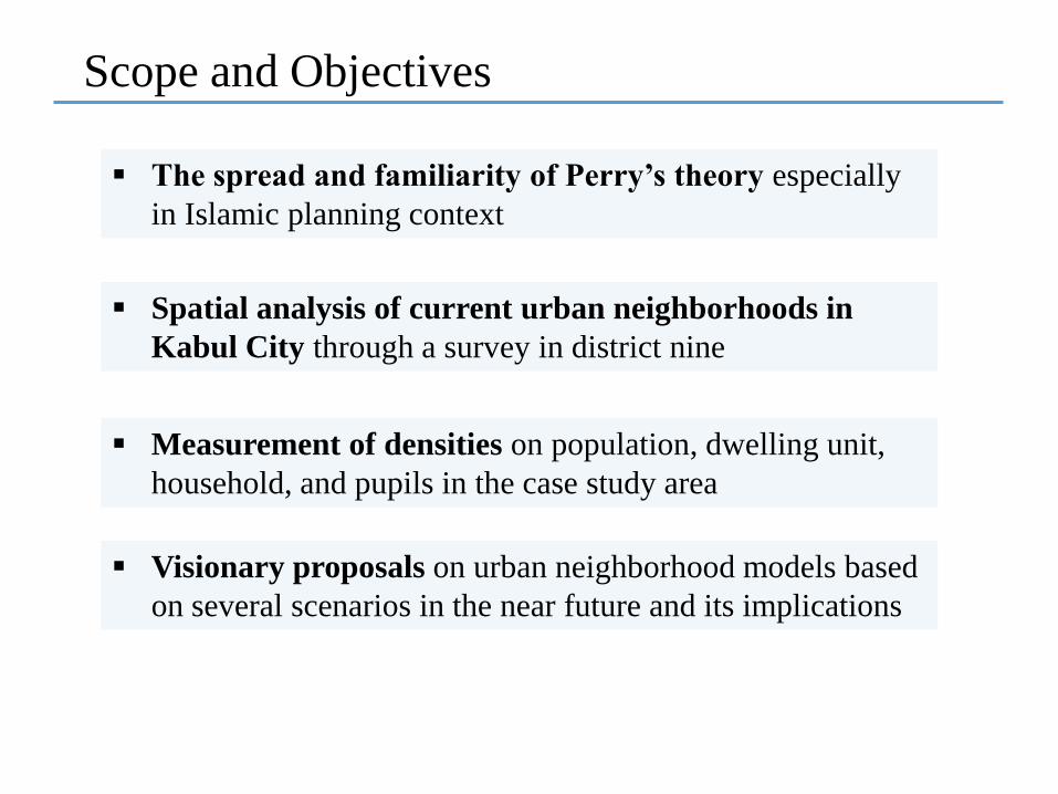
Scope and Objectives
The spread and familiarity of Perry’s theory especially
in Islamic planning context
Spatial analysis of current urban neighborhoods in
Kabul City through a survey in district nine
Measurement of densities on population, dwelling unit,
household, and pupils in the case study area
Visionary proposals on urban neighborhood models based
on several scenarios in the near future and its implications

The Spread and Familiarity of Perry’s Theory
The concept of neighborhood has existed since centuries
ago in different continents of the world
The planned residential
neighborhood probably finds its
most complete description in
Clarence A. Perry’s monograph,
‘The Neighborhood Unit’
The ideal neighborhood unit was
centered on an elementary school
and community center, and
bounded by arterial streets

The Spread and Familiarity of Perry’s Theory
In Islamic countries, there were traditional neighborhood
concepts to organize the people’s settlement spatially,
socially, administratively and sometimes politically and
economically
Mahalleh, Gozar and Fareej are the names for these
neighborhoods
These neighborhoods were: organized around a religious building;
included a school, retail/shops/market, open space and;
spaces for the community

The Spread and Familiarity of Perry’s Theory
Planning these traditional neighborhoods by:
Perry’s primary school district neighborhood is
expected to be a good model for this purpose
Not only helps better performance of existing functions,
but also reinforce much wider neighborhood functions
Setting up the optimal size and population
According to institutions such as community centers or
primary schools

Transformation of Gozar with urban neighborhood functions in Kabul
Oven Making Gozar, Kabul
Microrayan Planned Gozar,
Kabul
Shar-e-Ara Unplanned Gozar,
Kabul
Traditional Gozars
Homogenous guilds in which a mix of
ethnicities, religions and social classes
were lived
Urbanized Gozars
Divisions of social classes, ethnicities and
settlement types
Institutionalized as sub-districts of
municipal governance
Enhancing the neighborhood functions in
Gozar is
Effective in solving inner city problems
-This is the reason we follow on the survey-

Findings of a Questionnaire Survey

Findings of a Questionnaire Survey
The neighborhood functions are not depended on the
population size and the urbanization age of the Gozars
Neighborhood functions better work in Gozars of
having various and frequent gatherings among
residents
Mosque functions as community center for the Gozar
Each Gozar is represented by a representative who is
elected by residents, approved by district municipality
and screened by the police department
The neighborhood functions better work in Gozars
located in planned areas

Case Study Survey
Survey Area is chosen district
nine due to:
Its location on inner city
zone of Kabul City
Having variety of settlement
types
Planned apartment houses,
Planned courtyard houses,
and
Un-planned courtyard
houses
The site survey was done
in 2013
In addition land use maps
of JICA and web-based
maps are used

Land Use
Originally all farmland that still remains in various locations and rapidly and
illegally changing to residential settlements
Residential: 36%
Agricultural land: 20 %
Vacant or bare land: 12%
Industrial land: 24% , remaining 8% is commercial or
public facilities outside Gozar boundaries
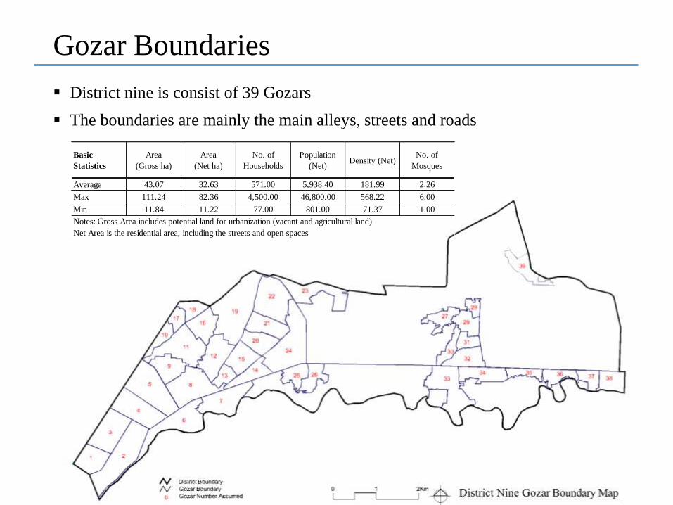
Gozar Boundaries
District nine is consist of 39 Gozars
The boundaries are mainly the main alleys, streets and roads
Basic
Statistics
Area
(Gross ha)
Area
(Net ha)
No. of
Households
Population
(Net)Density (Net)
No. of
Mosques
Average 43.07 32.63 571.00 5,938.40 181.99 2.26
Max 111.24 82.36 4,500.00 46,800.00 568.22 6.00
Min 11.84 11.22 77.00 801.00 71.37 1.00
Notes: Gross Area includes potential land for urbanization (vacant and agricultural land)
Net Area is the residential area, including the streets and open spaces

Primary Schools
Total 15 primary schools
12 with higher schools, 3 standalone
Basic
Statistics
Total
Enrollment
(Pupils)
Area
(Planned ha)
Area
(Unplanned
ha)
PopulationNo. of
Households
Average 2319.53 135.08 79.95 15463.56 1486.88
Max 4326.00 251.93 149.10 28840.00 2773.08
Min 347.00 20.21 11.96 2313.33 222.44
Area excludes vacant and agricultural Land, includes the streets and open spaces
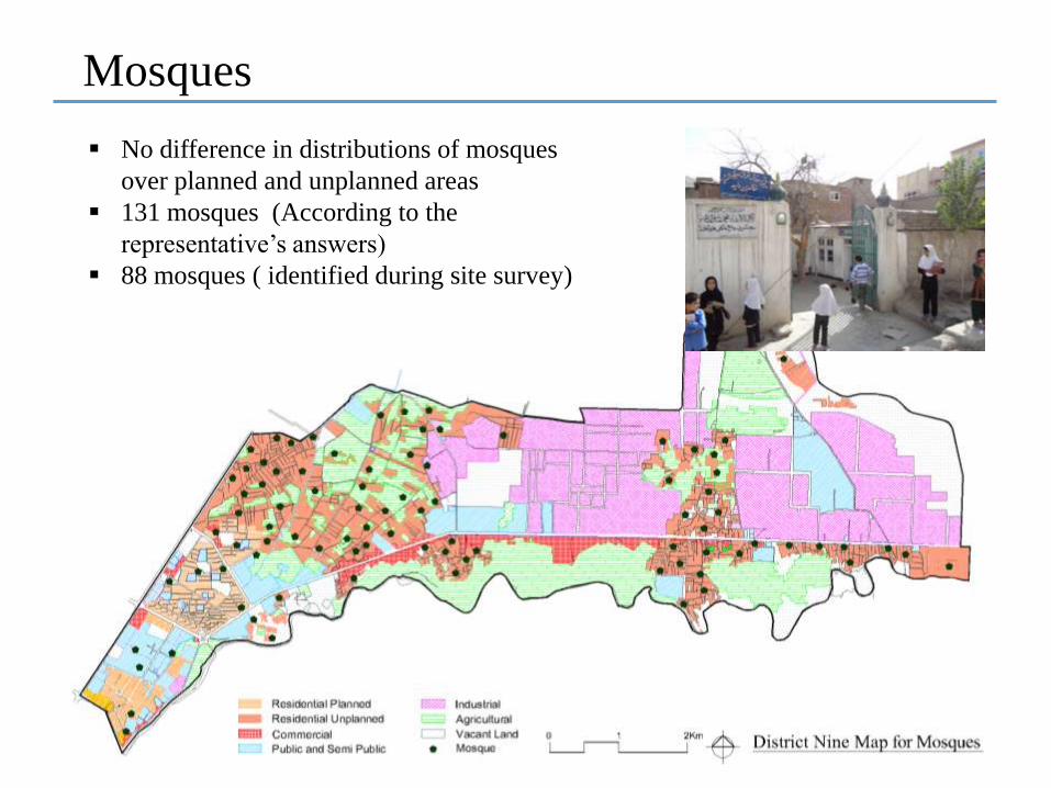
Mosques
No difference in distributions of mosques
over planned and unplanned areas
131 mosques (According to the
representative’s answers)
88 mosques ( identified during site survey)

Overall

Demographic Estimations
The planned density is measured through sampling within entire Kabul City by using aerial maps
The measured density (11.01 dwelling units/ gross ha) is applied to the potential land for development (vacant land and agricultural land)
Procedure:
Demographic
estimations for district
nine
Demographic Indicators JICA 2011 CSOMeasurements by
Map
Area (Km2) 25.5 - *35.8
Number of dwelling units - - 22,271
Number of households per dwelling unit 1.56 - -
Household size (persons/household) 6.69 6.33 -
No. of persons per dwelling unit 10.4 - -
Population (persons) - 250,100 -
*The gross area within district boundaries

Demographic Estimations Cont.
Pupils’ number and number of classes required are found for full and current enrollment ratios and scenarios are assumed
Scenario
assumptions
Estimation of
pupils’ current
and full
enrollment ratio
Pupils' Enrollment Indicators
Current enrollment ratio
according to school
survey of 2013 (a) case
Full enrollment ratio
according to ACSO [1]
(b) case
Percentage of pupil's population 15.0% 19.2%
Pupils' enrollment percentage 78% 100%
Pupil's number 34,793 44,471
Pupils' no. in each grade 5,799 7,412
Number of classes for each grade 145 185
Comparisons between the
scenarios and the current
state
Population growth in
full-built-up casePupils’ enrollment percentage
A. Estimated population in well-planned
case [current population + planned density
x (vacant land + agricultural land)]
Aa: Scenario 1, Ab: Scenario 2, Ba: Scenario 3, Bb Scenario 4
B. Estimated population in unplanned case
[current population + unplanned density x
(vacant land + agricultural land)]
a. All the primary school aged children
are to be enrolled in primary schools
(100% enrollment)
b. Pupils' enrollment percentage to be
the same as current enrollment
percentage(78% enrollment)
Current State(A) Full built-up
state (Planned)
(B) Full built-up state
(Unplanned)
1272.56 2,416.27 2,416.27
22,271 34,863 43,544
231,618 362,578 452,858
100 % Pupil enrollment ratio 44,471 69,615 86,949
Classes required 1,112 1,740 2,174
Classes required for each grade layer 185 290 362
Current pupil enrollment ratio (78%) 34,793 54,465 68,027
Classes required 870 1,362 1,701
Classes required for each grade layer 145 227 283
* According to the Education Law of Afghanistan, the number of pupils per class is taken 40
Specifications
Area
Number of dwelling units
Population
(a)
(b)

Scenario 112 classes
primary school
24 classes primary
school36 classes primary school
Total number of classes 1,740 1,740 1,740
Number of primary schools 145 73 48
Primary school district population 2,500 5,000 7,500
Number of households 240 481 721
Primary school district area (gross ha) 22 44 65
Scenario model
Primary School
Mosque
Open Space
Shops
Main Road45º
45º700m
700m
800m
800m
45º
500m
500m
Vision Proposal Models
For finding the number of primary schools:
Three options of full day school program are explored
Among them, the primary school of 24 classes is proposed to be the adequate size
Vision models of school district Gozars (full-day school program) in planned full-built-up state for full
enrollment of pupils
Walking distance of the
children
The current distance
between most of the main
roads in Kabul City is
from 500 to 700 meters
Kabul Municipality tries
to standardize the Gozar
size to 500 houses or
dwelling units
Current average Gozar
size (43.1 ha, 6000
population)
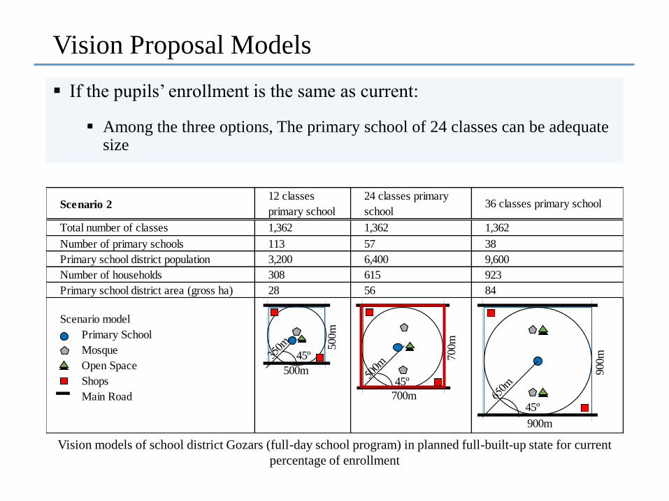
Scenario 212 classes
primary school
24 classes primary
school36 classes primary school
Total number of classes 1,362 1,362 1,362
Number of primary schools 113 57 38
Primary school district population 3,200 6,400 9,600
Number of households 308 615 923
Primary school district area (gross ha) 28 56 84
Scenario model
Primary School
Mosque
Open Space
Shops
Main Road
45º
700m
700m
900m45º
500m
500m
900m
45º
If the pupils’ enrollment is the same as current:
Vision Proposal Models
Vision models of school district Gozars (full-day school program) in planned full-built-up state for current
percentage of enrollment
Among the three options, The primary school of 24 classes can be adequate size

Scenario 324 classes
primary school
36 classes primary
school
48 classes primary
school
Total number of classes 2,174 2,174 2,174
Number of primary schools 91 60 45
Primary school district population 5,000 7,500 10,000
Number of households 481 721 962
Primary school district area (gross ha) 26 39 52
Scenario model
Primary School
Mosque
Open Space
Shops
Main Road
500m
45º
600m
600m
45º
500m
500m
45º
700m
700m
For full enrollment of pupils:
Vision Proposal Models
Vision models of school district Gozars (full-day school program) in unplanned full-built-up state for full
enrolment of pupils
Among the three options, The primary school of 36 classes can be adequate
size

Scenario 424 classes primary
school
36 classes primary
school48 classes primary school
Total number of classes 1,701 1,701 1,701
Number of primary schools 71 47 35
Primary school district population 6,400 9,600 12,800
Number of households 615 923 1,231
Primary school district area (gross ha) 33 50 66
Scenario model
Primary School
Mosque
Open Space
Shops
Main Road
500m
45º
600m
600m
45º
700m
700m
45º
700m
00000
800m
800m
If the pupils’ enrollment is the same as current:
Vision Proposal Models
Vision models of school district Gozars (full-day school program) in full-built-up state for current
percentage of pupils’ enrolment
Among the three options, The primary school of 24 or 30 classes can be adequate sizes

According to the four scenarios, proposals for school district Gozar could be as:
In planned areas:
Centered with a 24 classes primary school for a population of 5000 to 6500
In unplanned areas:
Centered with a 24 to 36 classes primary school for a population of 5,000 to 9,600
Having one or two Mosques located at the center or each half of the Gozar
The boundaries to be determined by the main roads, and the main roads should not go through the primary school districts
Vision Proposal Models
Conclusions
There are Wide variety of sizes and activities of Gozars in Kabul
These suggested that ‘Urban Gozar’ as an elemental neighborhood organization in the modern sense is transforming through urbanization
This urbanization requires a comprehensive spatial standard on urban neighborhood
A new spatial standard is explored as primary school district and also adopted in scenarios under assumption of planned and unplanned development, concerning the current needs for spatial urban model and compulsory education
It is finally concluded that one or two of the current Gozars can be combined to make an appropriate school district Gozar

Thank You Very Much

Primary School District for old built-up city area
The Gozar Sizes for Different Urban Areas
Gozar Primary School District
< G2
G1
G3
P.S

Primary School District for urbanizing area
The Gozar Sizes for Different Urban Areas
Gozar Primary School District
= G P.S

Primary School District for suburban area
The Gozar Sizes for Different Urban Areas
Gozar
Primary School District
> G P.S