
A transport delivery plan for Kent › __data › assets › pdf_file › 0017 › 6092 ›...
64
Growth without gridlock A transport delivery plan for Kent December 2010
Transcript of A transport delivery plan for Kent › __data › assets › pdf_file › 0017 › 6092 ›...

Growth without gridlock A transport delivery plan for Kent
December 2010

Oliv
erM
anni
on

Growth without gridlockA transport delivery plan for Kent
ContentsForeword: our offer to Government 2
1. Introduction 3
2. Delivering Growth and Prosperity 5
3. Unlocking Kent’s Potential 6
4. Transport’s Wider Contribution 8
5. Our 20 Year Funding Plan 10
6. The Thames Gateway: gearing up for growth 15
7. The Channel Corridor: relieving the pressure 26
8. West Kent: cutting congestion along the A21 corridor 36
9. East Kent: radical solutions needed 41
10. An Integrated Public Transport Network: supporting Kent’s workforce 47
11. Local Development Frameworks: securing infrastructure 55
12. Priorities for Growth without gridlock: the big, key, transport drivers for change 60
Gro
wth
without
grid
lock
A t
ransp
ort
deliv
ery
pla
n f
or
Kent
1

ForewordOur offer to GovernmentKent has South East England’s greatest potential to deliver economicgrowth worth billions of pounds to the UK economy and to stimulateprivate-sector-led recovery.
The schemes identified in this programme for regeneration form acollective package which, if delivered in its totality, will deliver benefitson a scale far greater than the sum of its parts.
Kent County Council (KCC) fully supports the Coalition Government’sview that the definition of local investment priorities should be in thehands of local government, working side-by-side with business andcommunities and we stand ready to take our delivery plan forward asan early pilot of this approach.
This document pulls together the big strategic transport solutions butdoes not try to include everything. It highlights those schemes that wefeel can be delivered by creative and innovative means. We want towork with Central Government and therefore ask of them:
1 Give KCC and its partners the power and funding to take forwardstrategic transport projects which were previously the responsibility of Central Government; to identify and realise efficiencies; and to deliver swift and meaningful growth.
1 We need cheaper and faster ways to deliver strategic infrastructure.We propose the transfer of Highways Agency budgets and powers tolocal transport authorities in order to remove the existing duplication of maintenance functions and to enable local government
2
and business to take more strategic decisions about sub-regionalpriorities so we can substantially reduce costs. This would enable KCC to progress long-awaited schemes such as the dualling of the A21 between Tonbridge and Pembury, which is crucial to relieving congestion and improving access to the new Pembury Hospital.
1 We also need Government to play its part. Given the nationalstrategic importance of the proposed Lower Thames Crossing, we have commissioned studies on the feasibility and benefits of this vitalpiece of infrastructure and ask the Government to act swiftly upon its commitment to conduct a detailed feasibility study of the principalcrossing options. We also ask the Government to hold firm on itspledge, in the National Infrastructure Plan, to bring forward a schemeof foreign lorry road user charging. The revenue raised from the charge must be used to fund a long-term solution to Operation Stack as well as the other vital schemes identified in this transportdelivery plan for Kent.
KCC has exciting and realistic plans for the future. We have alreadyproduced 21st Century Kent – Unlocking Kent’s Potential, ourframework for economic development over the next 20 years and withour excellent track record of working with Government and businessto bring forward strategic infrastructure schemes, we have in place aclear strategic base on which to proceed and are now ready to deliver.The Country is at a crossroads and we need to get on anddeliver these improvements.
Paul CarterLeader of Kent County CouncilDecember 2010

1. Introduction The ability to travel freely around our County is essential to oureveryday lives. A good transport network is vital for Kent’s residents andbusinesses to have access to opportunities, goods and services,to attractnew companies into the County, to stimulate economic growth andregeneration and to help us cope with the demand for increased housing.
We expect to be able to travel easily, safely and quickly. We need to berealistic - the private car will continue to remain the most popular anddominant form of transport for our residents and these expectationsand demands increase pressure on our transport network, on ourenvironment and on us as individuals.
This reliance is also the reason why our road network is congested andin response our vision is to create a high quality integrated transportnetwork which will create opportunities for real transport choice as
well as enabling economic growth and regeneration. Enhanced road, railand bus networks will reinforce and support each other, providing Kent’s residents and businesses with comprehensive and reliabletransport choices.
As well as maximising opportunities for travel using the existingtransport network, we will seek to introduce much needed newinfrastructure to stimulate economic growth, through alternativesources of funding.
Kent’s growth agenda is huge. We will ensure that new communities aredesigned in a way that embraces travel choice and where the transportnetwork enables residents and businesses to prosper. Set against this, wewill continue to develop our County in a sustainable way, which minimisesthe effect of pollution and climate change on the environment.
Gro
wth
without
grid
lock
A t
ransp
ort
deliv
ery
pla
n f
or
Kent
3

Kent is the UK’s front door
4

2. Delivering Growth and Prosperity The Greater South East is the only area of the UK that can compete with the major regional economies of Europe,Asia and the Americas.It is one of the world’s biggest markets for UK business and the revenue generated by its high value economy supports investment inother areas. Yet its future success is critically dependent on theresilience of Kent’s transport network, including its strategic links toEssex and East Sussex.
Kent has the UK’s only High Speed rail line, offering frequent servicesto a range of northern European destinations via the Channel Tunnel. Itis home to the country’s busiest and most successful ferry port atDover, which has ambitious plans for expansion to meet growingdemand for cross-Channel freight. And it has an emerging internationalairport at Manston with the capacity to cater for the increasing freightand passenger movements expected at South East airports over thenext 30 years.
Kent has the South East’s greatest potential for successful economicgrowth.The County boasts Britain’s largest quantity of high qualityaffordable development land, all of which benefits from excellentconnectivity and access to Kent’s stunning countryside and coast. In theThames Gateway, the delivery of 53,000 new homes and 58,000 jobsform part of Europe’s largest regeneration programme, while theGrowth Area of Ashford and the Growth Points of Dover andMaidstone offer excellent prospects for private sector jobs growth.
If Kent is to accommodate this growth, its transport network must havesufficient capacity and resilience to provide for efficient and reliablejourneys. However, the County’s highway network is already overloaded
at critical points and is particularly vulnerable to incidents at theDartford Crossing and the Channel ports.
Kent also has pockets of social disadvantage which require urgentattention, concentrated within those seaside towns in East Kent whichhave yet to feel the benefit of the High Speed rail services andemployment opportunities. Transport has a key role to play in enablinga transformation of the fortunes of such communities.
KCC, together with local businesses and stakeholders, has thereforedeveloped a plan of action for funding and delivering improvements tothe County’s strategic infrastructure. The schemes contained withinthis plan are entirely consistent with the strategic direction outlined inthe Coalition Government’s 2010 Comprehensive Spending Review andNational Infrastructure Plan. They will deliver productivity benefitsworth billions of pounds a year and will be paid for through innovativefunding mechanisms such as Tax Increment Financing (TIF), banningforeign lorry “belly tanks” and a port landing charge, thereby minimisingthe costs to the public purse.
In taking forward these proposals, we want to get the most out of theCoalition Government’s localist approach to economic growth and todemonstrate that putting business and local government in charge –through the Kent, Greater Essex and East Sussex Local EnterprisePartnership – can deliver swift and practical results.
Gro
wth
without
grid
lock
A t
ransp
ort
deliv
ery
pla
n f
or
Kent
5

3. Unlocking Kent’s Potential The need for a Transport Delivery Plan for Kent was identified in KentCounty Council’s framework for regeneration entitled “Unlocking Kent’sPotential: opportunities and challenges”.
This framework identifies the key opportunities and the challenges thatmust be addressed to deliver long lasting regeneration and economicgrowth in the County and, through the 21st Century Kent—UnlockingKent’s Potential delivery plans, establishes a series of priority areas foraction by the County Council and its partners for the next 20-30 years.
Unlocking Kent’s Potential redefines regeneration to include not onlyeconomic growth but also transformation in education and skills, theculture renaissance in the County, an efficient transport system,developing a strong civic spirit, tackling climate change and improvinghousing conditions. It sets a clear direction for achieving economicgrowth and diversifying Kent employment; particularly across theprofessional sector.
Unlocking Kent’s Potential represents the County Council’s first steptowards defining what Kent will look like in the future and provides abaseline for a broad policy approach that will inform the developmentof a series of further strategies and implementation plans.
These strategies will become the collective evidence base to informfuture strategic investment plans. A Transport Delivery Plan for road,rail, air and sea, which addresses the key transport solutions that needto be implemented over the next 20-30 years, is one of these keystrategies which will enable us to ‘Unlock Kent’s Potential’ and supportthe County Council’s Environment Strategy target of reducing
greenhouse gas emissions by 20% by 2020, 40% by 2030 and 80%by 2050.
A key delivery strand of 21st Century Kent—Unlocking Kent’s Potential,“Growth Without Gridlock” outlines how economic growth andregeneration can be delivered in a sustainable way and whatinfrastructure is needed to deliver an integrated transport networkwhich is fit for purpose in the 21st Century.
Cre
dit:
Land
Secu
ritie
s
6

Deliver 50,000 jobs and 25,000 homes at Ebbsfleet and Eastern Quarry
MEDWAY Capacity of Dartford Crossing
Overnight lorry parking and Operation Stack
M20 capacity
Capacity of M25 and M26/A21 link
A21 capacity
Support development of land in Sheppey, M2, J5 and Sittingbourne
Capacity at Brenley Corner (M2, J7)
Ensure growth at Maidstone has good access to M20
Development at KIA to 4.7 MPPA
South Canterbury need to link 4,000 homes with A2 & city centre -Bridge interchange
Growth Point supports Dover regeneration and ensure Whitfield/White Cliffs linked to town centre
Additional access to Ashford needed at new M20 J10A
40% of sub-region housing requires public transport link to Ashford town centre (Smartlink)
Growth Point
Growth Area
Transport Challenge
Airport
Gro
wth
without
grid
lock
A t
ransp
ort
deliv
ery
pla
n f
or
Kent
Figure 3.1 Kent’s Transport Challenges
7
4. Transport’s Wider Contribution Transport is vital not as an end in itself but as an enabler of economicgrowth and regeneration and many essential social activities.The way inwhich we plan and operate our transport networks also has asignificant impact on the quality of our environment.
“Growth Without Gridlock” identifies the necessary transportinfrastructure needed to accommodate the level of economic growthand regeneration planned for Kent, the measures required to managethe existing network and offers travel choice and better access to jobs.
Managed Economic GrowthSustainable economic growth and regeneration is reliant oncomprehensive and resilient transport networks.These networks areessential to increasing business efficiency by generating time savings andimproved reliability for business travellers, freight and logisticsoperations.They support clusters of economic activity, expand labourmarket catchments, and facilitate business-to-business interactions.
Kent’s economy is not as prosperous as other parts of the South East,with a Gross Domestic Product (GDP) per head of population wellbelow the regional average, and a relatively high unemployment rate.These problems are particularly acute in areas of East Kent and aroundthe coastal fringe, which until recently have suffered from relativelypoor road and rail links.
In order to achieve the scale of economic growth necessary to supportsustainable development in the County’s Growth Areas and the regenerationof our coastal towns, it is vital that business and retail sites are wellconnected to reliable and integrated multi-modal transport networks.
Supporting IndependenceThe last decade has seen changes in the age profile of Kent’spopulation.The most significant population increase has been amongthe 45-59 age group and as a consequence, Kent will have a populationthat is much older in 10 to 15 years than it is today. Forecasts predictthat the older age groups will be found in Thanet, Shepway, Canterburyand Dover with predominately younger populations in Ashford andDartford.
These differences in population across Kent need to be taken intoaccount when we consider improvements to the transport network,especially relating to access to key services, vulnerability, personal safetyand affordability. “Growth Without Gridlock” supports the policyframework for Living Later Life to the Full by looking to improveaccessibility to key services by public transport including health centres,GP surgeries and hospitals.
Rural IssuesKent is a rural county. Some 85% of Kent’s land area is classified as ruraland almost 30% of the County’s residents live in rural areas. Whileseveral of Kent’s districts regularly top national surveys measuring quality of life and the wealth of residents, almost half of the South East’sworst areas of rural disadvantage are to be found in Kent.These areconcentrated in the districts of Ashford, Shepway and Swale. Kentalso has a significant number of rural residents with few skillsand qualifications.
Most rural residents live in large villages and there is the potential foran improved transport network, including pedestrian and cycling routes
8

to connect these communities with each other and major urbancentres. Other important issues are the impact of traffic on rural roads,especially lorries using inappropriate narrow lanes and speeding onremote country roads.
Health and Road SafetyTransport has both positive and negative impacts on people’s health.Improving accessibility to hospitals, health centres and GP surgeriesmakes it easier for people to seek immediate treatment rather thandelay care due to lack of transport. Moderate activity plays a part inimproving health and walking and cycling are good forms of exercisethat can easily be incorporated into our busy lives. Health and roadsafety are interlinked, and reducing casualties caused by vehiculartraffic is a constant priority for central and local government. Recentyears have seen a gradual decline in road casualties through changesto the highway and vehicle design, awareness raising, education and enforcement.
There are 36 areas in Kent where air pollution, caused by road traffic,exceeds the Government’s objectives and these can lead to respiratorydisease and illness.Although previously located mainly on the motorwayand trunk road network, the number of locations on local roads inurban areas is steadily increasing.
Climate ChangeIn the South East, it is suggested that by 2080, summers will be hotterby 2-6ºC and summer rainfall will decrease by 20-60%; winters will bewarmer by 1.5-3.5ºC and winter rainfall will increase by 10-30%. Kentis particularly vulnerable, due to its location and stretches of lowlying coastline.
Road transport is responsible for around 30% of Kent’s greenhouse gasemissions.The way forward is to provide low-carbon transport optionsallied with better planning to reduce the need to travel which willsupport economic growth and housing growth and tackle climatechange, supporting the Kent Environment Strategy target as ourcontribution to the UK Climate Change Act (2008) greenhouse gasreduction targets.
Gro
wth
without
grid
lock
A t
ransp
ort
deliv
ery
pla
n f
or
Kent
9

5. Our 20 Year Funding Plan In the wake of the Coalition Government’s 2010 ComprehensiveSpending Review it is clear that public sector funding for transportinfrastructure will be very limited for the foreseeable future, meaningthat local authorities cannot continue to rely on existing fundingstreams. Nevertheless,we are committed to securing the timely deliveryof planned housing and employment growth which will kick-start theeconomic recovery in Kent and the wider South East.The CountyCouncil has therefore taken bold and innovative steps to identifyalternative sources of funding which, taken in their totality, couldgenerate some £616 million per year over the next 20 yearswithout any recourse to the public purse. We are working closely withGovernment to unlock this funding and have already achieved positiveprogress, including commitments by the Department for Transport tointroduce a scheme of foreign lorry road user charging by 2014 and tohypothecate future Dartford Crossing toll revenue towards the cost ofa new Lower Thames Crossing.
Dartford Crossing and LowerThames CrossingThe total capital cost of the proposed Lower Thames Crossing has beenestimated by Gifford as being in the region of £1 billion, with thenecessary link roads into the motorway network north and south ofthe Thames costing up to a further £2 billion. Over a 20 year period,toll revenues from the new crossing, plus those from the existingDartford Crossing, could support around half of these costs, and foreignlorry road user charging and a resident planning tariff in ThamesGateway Kent could provide the remaining funding. Given that thecapital cost of the Queen Elizabeth II Bridge has been paid for, there is astrong case for using the net operating surplus to supportinfrastructure investment that encourages economic development in
the area that feels the impact of the toll most acutely.This has beenfacilitated by the Coalition Government’s announcement, as part of the2010 Comprehensive Spending Review, that it has decided not to sellthe Dartford Crossing at this time and that the crossing charges forcars will be raised to £2.00 in 2011 and £2.50 in 2012.This will fund theprovision of free-flow tolling using Automatic Number PlateRecognition (ANPR) cameras from late-2011, and will contribute to thecapital cost of the new crossing in the longer-term.
Banning of ‘belly tanks’We and the Freight Transport Association (FTA) are deeply concernedby the practice followed by many foreign hauliers of carrying largeadditional ‘belly tanks’ of up to 1,000 litres of diesel.These give driversthe capacity to travel from Luxembourg to Aberdeen and returnwithout the need to fill up their fuel tanks, and thus further enhancetheir ability to avoid paying UK fuel duty. It has been calculated that theUKTreasury loses approximately £475 million a year in potentialtax revenue as a result.This practice also presents a significant healthand safety hazard on cross-Channel rail and ferry journeys and we willwork with the FTA and Government to outlaw it as quickly as possible.If this is achieved, up to £9.5 billion of additional revenue could becaptured over the 20-year period of this Delivery Plan, which couldhave a transformational impact on transport infrastructure investmentin Kent, including the delivery of the Operation Stack lorry parkbetween Junctions 10 and 11 of the M20 and the upgrading of the A2corridor in East Kent.
10
Tax Increment Financing (Thames Gateway Kent)We strongly welcome the Coalition Government’s recentannouncement that local authorities will be given the power tointroduce Tax Increment Financing (TIF) schemes.TIF is a fundingmethod used for infrastructure investment in a number of countries,including the United States. It uses forecast future gains in taxation tofinance infrastructure improvements.These improvements serve toincrease the value and desirability of surrounding land and hencepromote further inward investment.This in turn generates greater taxrevenues, enabling local authorities to recoup their initial investment.TIFhas significant potential to provide a sustainable funding model tosupport Kent’s growth aspirations. A tentative assumption would bethat 35% of the GrossValue Added (GVA) impacts of a new LowerThames Crossing would be captured in taxation and could thuscontribute up to £117 million a year for local infrastructureinvestment.
Resident Planning Tariff (Thames Gateway Kent)The resident planning tariff, or ‘roof tax’, is based on existing practicesof levying standard charges on new developments, such as the MiltonKeynes Tariff. Under resident planning tariff arrangements, new housingdevelopments given planning permission would pay a set contributionto the cost of new infrastructure.The amount each development wouldpay per dwelling would vary across Kent; however a reasonableassumption would be that new dwellings in the Thames Gateway KentGrowth Area should contribute approximately £10,000 each in tariffpayments, representing a contribution of £10 million per yearover the 20-year period of this Delivery Plan.
Foreign Lorry Road User ChargingKCC is delighted at the Coalition Government’s commitment, in itsNational Infrastructure Plan, to introduce a scheme of foreign lorryroad user charging.The Government has listened to the evidence wehave presented and will implement a vignette imposing a standardcharge on all lorries entering the UK.This would provide an importantnew revenue stream of up to £40 million a year (£640 million overthe 20-year period of this Delivery Plan), as well as levelling the playingfield for UK hauliers vis-à-vis their foreign counterparts, many of whomenter the UK with full fuel tanks and hence make no contribution tothe costs they incur in this country through road damage, congestionand emissions.
‘…We will work towards the introduction of a new system of HGV road usercharging to ensure a fairer arrangement for UK hauliers….
The Coalition: our programme for government - July 2010
Port Landing Charge (cars and coaches)The practice of levying a small development charge on internationalpassengers is already well established at a number of UK airports.Thecharge is used to fund improvements to the airport environment,including parking areas and access roads. We believe that this practiceshould also be adopted by the UK’s major seaports (including Doverand Ramsgate) and the Channel Tunnel, in order that international carand coach passengers make a reasonable contribution to the economicand environmental burdens they place on Kent’s residents, businessesand infrastructure.The charge would not be levied on HGVs, given thathauliers would be asked to make a separate contribution through theproposed foreign lorry road user charge (see above). A charge of just£5 for each car and coach entering the UK would generate some £12.5 million per year for investment in local transportimprovement schemes.
Gro
wth
without
grid
lock
A t
ransp
ort
deliv
ery
pla
n f
or
Kent
11

Releasing additional funding
Ashford-Ramsgate line speed improvementsKCC has recently supported a Network Rail study to identify potentialline speed enhancements between Ashford and Ramsgate viaCanterbury West.The study found that journey times between the twotowns could be reduced by up to 10 minutes and that the strength ofthe business case for the necessary improvement works justifies some£5 million investment for every minute saved, representing a potentialtotal of £50 million. Network Rail has therefore committed toprepare a full business case for the scheme, which is currentlyscheduled for implementation in 2014.
Thanet Parkway StationInitial feasibility analysis by KCC suggests that there is also a strongbusiness case for a Thanet Parkway station close to Kent InternationalAirport (KIA).The County Council, together with Thanet DistrictCouncil and Network Rail, is currently preparing a bid to theGovernment’s Regional Growth Fund to bring forward theimplementation of the new station, which has an estimated cost of £10 million. Last year’s Total Place pilot in Thanet identified millions ofpounds worth of potential savings to the district’s £180 millionwelfare bill, which could be achieved by delivering public servicesmore efficiently. If we are to realise these savings and to lock in thebenefits of reduced dependency for the long-term, it makes sense thatsome of this money should be used to fund new transportinfrastructure and services which will improve accessibility to jobs andservices.
Integrated Bus NetworkBy taking forward the successful model of partnership working withKent’s commercial bus operators which has delivered patronage growthof some 65% over the past 10 years, KCC would be in a position tomake an unprecedented level of investment in bus routeinfrastructure to the level of £80m. We have already receivedagreement in principle that the County’s major commercial busoperators would be prepared to match-fund such an investment, whichwould secure significant service improvements, new low-emissionvehicles and improved marketing and information.
In addition we will also pursue European funding opportunities such asthe European Regional Development Fund.
The tables opposite provide a detailed annual breakdown of our20 year funding plan. Please note that the figures provided are based onthe capital costs emerging from our scheme feasibility studies and thelatest available statistics for international road traffic, Dartford tollincome and housing delivery.They are therefore indicative only and willrequire more detailed analysis by KCC and Central Government aseach funding model is developed and implemented.
12

Third Thames Crossing £1000 million
Enhancements to M20/M2 £500 million
Bifurcation
Operation Stack
Network Rail Upgrade to Thanet (including Manston Parkway station) £40 million
Integrated/Enhanced Public Transport (bus network etc) £80 million
A21 Dualling £50 million
Other District-based road improvements £100 million
Total £1.77 BILLION
Spread over 25 years annual revenue cost (incl. interest and repayment) £154 million p.a.
Increased Tolls at Existing Dartford Crossing £20m additional revenue
Third Thames Crossing Toll (assuming transport growth) £30 million
Increased DERV Duty banning belly tanks to EU HGVs £475 million
TIF tariff (approx 20% on roads & public transport) £23.4 million
Resident Planning Tariff – 20% on roads £10 million
Vignette for foreign lorries £40 million
Port Landing Charge £12.5 million
EU Trans European Network Funding £5 million
Total £615.9 million p.a.
Estimated Capital Costs of Priorities for Growth
Our Offer to Government Per annum
Gro
wth
without
grid
lock
A t
ransp
ort
deliv
ery
pla
n f
or
Kent
Note - These estimated figures do not include any GVA increase or welfare reduction to DWP
13
MEDWAY
Dartford
Gravesend
Tonbridge
Tunbridge Wells
Maidstone
Faversham
Whitstable Herne Bay
Margate
Ramsgate
Deal
Canterbury
Dover
ChannelTunnel
Folkestone Hythe
Ashford
Sevenoaks
Ebbsfleet
Sheerness
M25
M25
A264
A21
A26
M26
A20
M20
A22
7
A22
8
A226
A249 A2
M2
A20
M20
A20
70
A259
A274
A229
A228
A262
A28
A25
1
A252
A28
A299
A28
A257
A25
6
A25
6
A25
8
A2
A26
0
Sittingbourne
CTRL
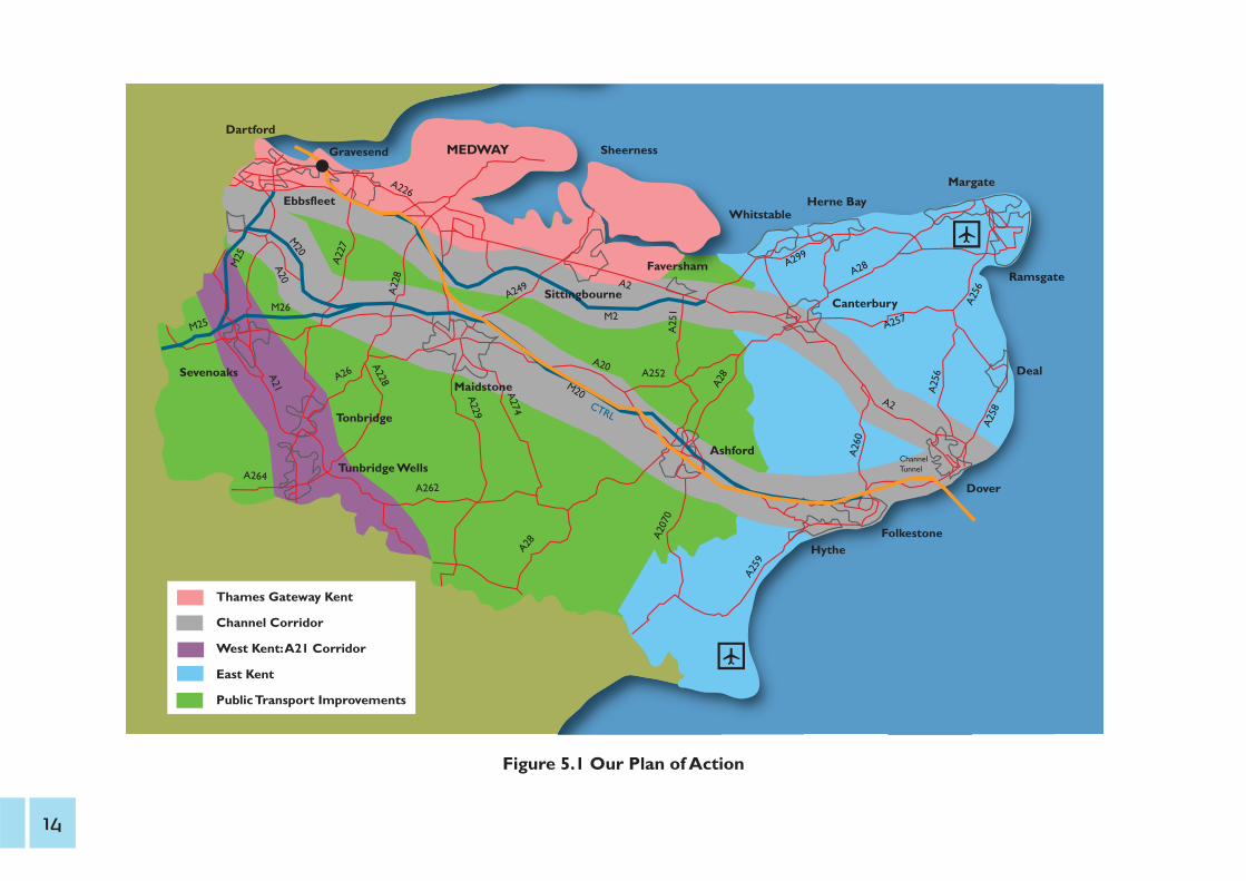
Thames Gateway Kent
Channel Corridor
West Kent:A21 Corridor
East Kent
Public Transport Improvements
Figure 5.1 Our Plan of Action
14

6. The Thames Gateway: gearing up for growth Issue: congestion at Dartford Crossing and its approaches
costs UK economy some £40m a year
Action: provision of a Lower Thames Crossing eastof Gravesend
Outcome: 6,000 jobs, contribute £12.7bn to local GVA (£334m a year), journey time reliability and increasednetwork resilience
Cost: £1bn (excluding access roads) funded from existing andfuture tolls and foreign lorry charging
Thames Gateway KentThames Gateway Kent covers the majority of the districts of Dartford,Gravesham and Swale including the main urban areas of Dartford,Gravesend,Northfleet, Sittingbourne and Sheerness. It joins up with Medway, SouthEssex and parts of East London to form the Thames Gateway GrowthArea. There is a target to develop 52,340 new homes and 58,000 jobsfor Thames Gateway Kent and Medway over the period 2006-2026.
The economy of Thames Gateway Kent has undergone a structuralshift over the past 20 years, reflecting the decline of the traditional localindustries of manufacturing, engineering, quarrying and powergeneration.Although this has been partially offset by growth inemployment in construction and finance, there remain significantpockets of unemployment and disadvantage in each of the GrowthArea’s constituent districts. Thames Gateway Kent nonetheless exhibitsgreat potential for growth and regeneration given its proximity toLondon and the wide availability of brownfield development sites.
This new housing and employment will be focussed around EbbsfleetInternational Station, with mixed-use communities planned for theEbbsfleetValley and Eastern Quarry development sites. New housingand employment in Swale will be focused around Sittingbourne andSheppey. Swale Borough Council is proposing the development of 8,700new homes over the next 15 years. The Port of Sheerness has plans formajor expansion which also incorporate new housing. The Port is thelargest employer in Sheerness and the scheme offers significant benefitsfor the town.
The area enjoys generally good road and rail links, being located on theM2/A2 corridor and having benefitted from the commencement ofSoutheastern High Speed services to London in December 2009.Unfortunately, connectivity across the Thames is very poor with majorcongestion at the Dartford Crossing limiting the growth of the wholeThames Gateway area. North-South links are also poor, which results incongestion on the main inter-urban routes to Maidstone andTonbridge/Tunbridge Wells. Within the area, this new growth will putpressure on local roads and therefore sustained investment in newinfrastructure is necessary.
Gro
wth
without
grid
lock
A t
ransp
ort
deliv
ery
pla
n f
or
Kent
15

11 19
22 6
3.9 22
3
4 8 8
8
18
8.4
3
2
18
106
1516
1.5
1.5 1.6
7.2
1.8
2.5
3.9
1.7
3.79
Southend
Tilbury
Grain Sheerness
Dover
Channel Tunnel
M25
M11
M2
M20
A127
A102 (M)
A13
A12
A282
A20 A2
A228
A249
A2
A20
Figure 6.2 HGV Flows per day 2008-09(thousands) - shows the volume (inthousands) of two-way HGV movementsper day on the strategic road network inKent and Essex. It illustrates the heavyreliance of road freight from Dover andthe Channel Tunnel travelling north, andfrom the major distribution centres in theMidlands travelling south, on the DartfordCrossing, which is part of the Trans-European Transport Network (TEN-T).
LowerThames CrossingThe Dartford Crossing is one of the UK’s most important strategicconnections. It offers the shortest freight route between the Kent portsand the major distribution centres in the Midlands and the north ofEngland and carries some 18,000 HGVs a day (see Figure 6.2).Yet thecapacity of the existing bridge and tunnels is considerably overloadedfor large periods of the day and, like all estuarial crossings, it has limitedresilience to incidents.
The Crossing experiences an average of 15 major incidents a yearwhich require the closure of some or all of the carriageways, along withfive additional closures of the Queen Elizabeth II Bridge due to highwinds.The wider impacts on the highway networks of Kent and Essexare severe and extensive, affecting the reliability of journey times for allroad users and costing the UK economy some £40 million ayear. Disruption at these times is increased since the alternative routesare significantly longer than the direct crossing.
16

It is clear that the current situation will only get worse. Not only willfreight volumes continue to rise but over 200,000 planned new homesin the Thames Gateway will generate their own demand.A solution isneeded that will free up this vital national connection and support jobcreation in Kent and Essex.
Having established a clear and pressing need for a new crossing, Kentand Essex County Councils jointly commissioned an independent studyto evaluate the principal options for the form and location of a newcrossing in 2008.This study was carried out by a team of consultantscomprising Gifford, MVA and Capita and looked at nine possiblelocations. KCC followed this in 2010 by commissioning a further studyby KPMG aimed at developing a business case for the crossing. Whilstall crossing options demonstrated positive economic benefits, theKPMG study identified that a new crossing between Chadwell in Essexand east of Gravesend, linking the M25 with the A2/M2 would havemajor economic benefits for the local area (see Figure 6.3 on page 18).
KCC has therefore adopted this as its preferred location and will nowwork with all partners and Government to further develop the case fora third crossing of the Thames.
“The Department for Transport intends to begin the necessary consultation on proposals for the new charging regime at the Dartford Crossing around the end of 2010.”
“Increasing the charges as proposed allows future investment in improvements at the Crossing, including the implementation of free-flow charging technology, and funding of proposals for a new, additional lower Thames crossing in the longer term.”
Michael PenningParliamentary Under Secretary of State (Roads and Motoring)
Benefits of a new Crossing to the east of Gravesend1 A new crossing to the east of Gravesend would remove the two
most important constraints on growth in the Thames Gateway, providing significant additional capacity on the strategic road network between the Kent ports and the Midlands.
1 The Chadwell to Gravesend option would unlock substantialregeneration opportunities. KPMG estimates that the crossing would create around 6,000 jobs in North Kent and SouthEssex and contribute £12.7 billion to local GVA (£334 million a year).
1 The Chadwell to Gravesend option would provide the potential to better serve the new London Gateway port, which is being developed by Dubai Ports World near Stanford-le-Hope in Thurrock.
Gro
wth
without
grid
lock
A t
ransp
ort
deliv
ery
pla
n f
or
Kent
17
M25
M11
Tha
mes
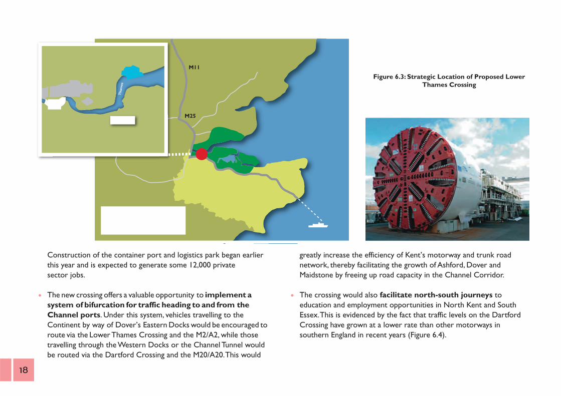
Figure 6.3: Strategic Location of Proposed Lower Thames Crossing
Construction of the container port and logistics park began earlierthis year and is expected to generate some 12,000 private sector jobs.
The new crossing offers a valuable opportunity to implement asystem of bifurcation for traffic heading to and from the Channel ports. Under this system, vehicles travelling to the Continent by way of Dover’s Eastern Docks would be encouraged toroute via the Lower Thames Crossing and the M2/A2, while those travelling through the Western Docks or the Channel Tunnel wouldbe routed via the Dartford Crossing and the M20/A20.This would
greatly increase the efficiency of Kent’s motorway and trunk roadnetwork, thereby facilitating the growth of Ashford, Dover andMaidstone by freeing up road capacity in the Channel Corridor.
The crossing would also facilitate north-south journeys to education and employment opportunities in North Kent and South Essex.This is evidenced by the fact that traffic levels on the DartfordCrossing have grown at a lower rate than other motorways in southern England in recent years (Figure 6.4).
1 1
18

Dartford Crossing - Transport Gap 200,000
Ave
rage
Dai
ly T
raff
ic F
low
(V
ehic
les)
180,000
160,000
140,000
Average Daily Flow on Southeast Motorways (rebased), HA
Average Daily Crossing Flow, HA
Naomi forecast assuming future growth in the area and Thames Gateway Bridge
Forecast using trend over last four years
Widening ‘Transport Gap’ threatens economic vitality by forcing travellers to endure further increases in congestion threaterning investment and regeneration in South Essex/North Kent and impacting on regional/national productivity
Naomi forecast from Getting the Most Out Of Dartford report for HA 2004
120,000
2003 2005 2007 2009 2011 2013 2015
Figure 6.4 Dartford Crossing Transport Gap - indicates that whilstaverage traffic levels per day have increased at the Dartford Crossing inrecent years, this has occurred at a lower rate than other motorways inSouth East England. This suggests that north south journeys toemployment, education and leisure opportunities are being suppressedby the available capacity. This ‘transport gap’ is projected to widenfurther in future years, which would have a significant impact on theeconomic vitality of the Thames Gateway should no additional crossingcapacity be provided.
1 By physically separating the new crossing from the existing one,there would be substantially more resilience in the transportnetwork, making it much less vulnerable to single incidents.
1 A new crossing would help to secure the development of an integrated bus network for the Thames Gateway, including the Fastrack and South Essex Bus RapidTransit schemes.Future work on the development of the route in Thurrock and Essexto be discussed with partners.
M20/M25 WideningThe Highways Agency plans to trial the use of hard shoulder running inpeak periods to increase capacity on the M25 Junctions 5-7 by 2015 andthe M20 Junctions 3-5 by 2019. We will work with them to co-ordinatethe work of our Traffic Management Centres to cut journey times
Gro
wth
without
grid
lock
A t
ransp
ort
deliv
ery
pla
n f
or
Kent
and continue to lobby for these improvements to be implementedwithout delay.
ThameslinkThe expansion of Thameslink rail services from 2018 will significantlyimprove access to and from the City.The County Council will lobby forKent to benefit from these new services and in particular for Maidstoneto be linked directly into the Thameslink network.
CrossrailCrossrail is an exciting new railway line running east to west acrossLondon from Maidenhead via Heathrow, Paddington and LiverpoolStreet stations to Shenfield in Essex and Abbey Wood. Due to becomplete by 2018, it will bring an additional 1.5 million people within 45minutes commuting distance of London’s key business districts.TheCounty Council welcomed the Coalition Government’s commitment, inthe 2010 Comprehensive Spending Review, that the project will be
19

delivered in full. We will now continue to work with Transport forLondon to make the case for the extension of Crossrail to Gravesendvia Dartford and Ebbsfleet International.
Congestion ManagementThe County Council’s recent investment in Urban Traffic Managementand Control (UTMC) system enables us to maximise the efficiency ofthe local highway network as traffic levels increase in line withdevelopment. Our Traffic Management Centre has successfully reducedaverage journey times into Maidstone town centre during peak periodsand we are expanding the system to cover Dartford and Gravesendtown centres.As well as reducing congestion, the UTMC will alsosupport measures implemented by Dartford and Gravesham BoroughCouncils to reduce traffic pollution in designated Air QualityManagement Areas (AQMAs).
Euro
star
Strategic Transport Investment Package SchemesTraffic modelling to support the Kent Thameside Transport Strategy hasidentified a number of future congestion hotspots which will resultfrom the major development planned for the area over the next 20years.This has led to the development of 11 Strategic TransportInvestment Package Schemes (STIPS) which will be primarily funded bythe Department for Transport, the Homes and Communities Agency,and developers. If all of these schemes can be delivered, they will help toreduce congestion at over-capacity junctions by 21% in the evening peakand reduce journey times by 3% or more by 2025.The 11 STIPSschemes are:-
1 A2 Bean junction improvements - to improve access between the A2, Eastern Quarry and Bluewater;
1 A2 Demand management - introduction of variable speedlimits, access management,Variable Message Signs (VMS) and vehicle priority lanes;
1 A2 Ebbsfleet junction improvements - to improve accessbetween the A2, Ebbsfleet International station, and Eastern Quarry;
1 A256 Thames Way dualling - to improve access to EbbsfleetInternational station;
1 Fastrack busway: Northfleet to Garrick Street, Gravesend -provision of dedicated Fastrack route to Gravesend town centre from new development area;
1 DartfordTown Centre improvements - to revise traffic circulation on the ring road and improve bus access in support of development proposals;
20
1 Rathmore Road link, Gravesend - provision of new section of one-way system to support new public transport interchange north of Gravesend rail station;
1 A226 London Road/B255 St Clements Way underpass -provision of underpass to improve junction capacity;
1 UrbanTraffic Management and Control (UTMC) -introduction of traffic signal control system, traffic flow monitoring using CCTV, additional signalised junctions,VMS and Real-Time Information (RTI);
1 A206 Bob Dunn Way junction improvement - conversion of Marsh Street roundabout to a signalised junction;
1 B262 Hall Road junction improvement - junction capacity improvement and traffic calming on Springhead Road.
SheernessSheerness is the largest UK port for fresh produce and has theopportunity to intensify its activity within its existing boundaries withthe option to expand onto nearby industrial areas.The Second SwaleCrossing has significantly improved road access to the port, butimproved rail access and facilities are needed to increase the amount ofrail freight to and from the port. A massive regeneration project totransform Sheerness Port was announced in September 2009, with amarina for up to 500 large yachts, three new deep water berths, newhousing and an extension of commercial shipping facilities.
ThamesportThamesport is the largest deep-water container port in Medway,carrying a relatively high volume of containers to and from the port byrail (some 20%). Further development of the port would benefit fromimproved access by the A228 and for more capacity on the branch.
Gro
wth
without
grid
lock
A t
ransp
ort
deliv
ery
pla
n f
or
Kent
21

Dartford
Dartford is located at the heart of the Thames Gateway, borderingGreater London and Essex. The A2 and M25 pass through the boroughand provide high capacity routes to London, the Channel Ports and thewider South East. There are five railway lines to London and the Kentcoast, as well as daily commuter coaches providing fast, direct servicesto Canary Wharf and the City.
An additional 17,000 homes are planned in Dartford over the period2006 to 2026, which will increase the borough’s population by over40%. New communities will be created in the Ebbsfleet to Stonecorridor, on the Thames waterfront and in Dartford town centre. Thelargest of these will be at Eastern Quarry, where more than 6,000homes will be built.
If this growth is to be delivered without creating transport gridlock, ahigh quality public transport network linking the new development siteswith local town centres, employment areas, transport interchanges andkey services is essential. Dartford’s growth strategy is thereforepredicated on the further development of the Fastrack Bus RapidTransit (BRT) network, including a direct route through the EasternQuarry development to Ebbsfleet International Station.
The key transport challenges for Kent Thameside are:1 Relieving the capacity and air quality issues at the Dartford Crossing1 Transferring existing and new car trips onto public transport, walking
and cycling, especially for short journeys1 Tackling congestion hotspots including the M25/A282 Dartford
Crossing, the A2 corridor including the Bean Interchange; andDartford town centre
22
1 Integrating rail services and improving connectivity between stationsto maximise the benefits of Southeastern High Speed services
1 Providing sufficient transport infrastructure to mitigate the impact ofthe planned development including walking and cycling routes
1 Mitigating the significant levels of traffic generated by Bluewater
ProposalsLower Thames Crossing to relieve congestion at the Dartford Crossing,potentially incorporating Fastrack facilities to extend this Bus RapidTransit system into the South Essex Rapid Transit system.
Bus and rail interchange at Dartford station.
Fastrack links to Northern Gateway development and through Eastern Quarry.
Gravesham
Gravesham is centrally located within Thames Gateway Kent and benefits from direct access to the A2 trunk road and the High Speed 1 rail line, which provide fast routes to London, the Channel Ports and the rest of the UK. The commencement of Southeastern High Speed rail services in 2009 brought a dramatic improvement in journey times to the capital from Gravesend (23 minutes) and Ebbsfleet International (17 minutes). The borough’s key transport link to the north is via the A282 Dartford Crossing, although a small passenger ferry operates between Gravesend and Tilbury in Essex.
The delivery of approximately 9,000 new homes is expected in Gravesham up to 2026. Key development sites include Gravesend town centre and Canal Basin and Northfleet Embankment. Ebbsfleet International Station is located in the west of the borough and will form the focus of a major mixed-use development. This will include a business district which will create up to 20,000 new jobs.
Like Dartford, Gravesham’s existing road network is already operating at close to maximum capacity during peak periods. Continuing modal shift to rail and bus services is therefore crucial if future levels of housing and economic growth are to be accommodated.
The key transport challenges for Gravesham are: 1 Transferring existing and new car trips onto public transport, walking
and cycling, especially for short journeys1 Tackling congestion hotspots including the A2 corridor including the
Bean Interchange; B262 Hall Road/Springhead Road; and Gravesendtown centre
1 Integrating rail services and improving connectivity between stations
to maximise the benefits of Southeastern High Speed services1 Providing sufficient transport infrastructure to mitigate the impact of
the planned development including walking and cycling routes
ProposalsLower Thames Crossing to relieve congestion at the Dartford Crossing,potentially incorporating Fastrack facilities to extend this Bus RapidTransit system into the South Essex Rapid Transit system.
Transport Quarter centred on Gravesend rail station.
Green Grid links to Shorne Wood Country Park.
Redevelopment of the Canal Basin area, including improvements toOrdnance Road junction.
Gro
wth
without
grid
lock
A t
ransp
ort
deliv
ery
pla
n f
or
Kent
23
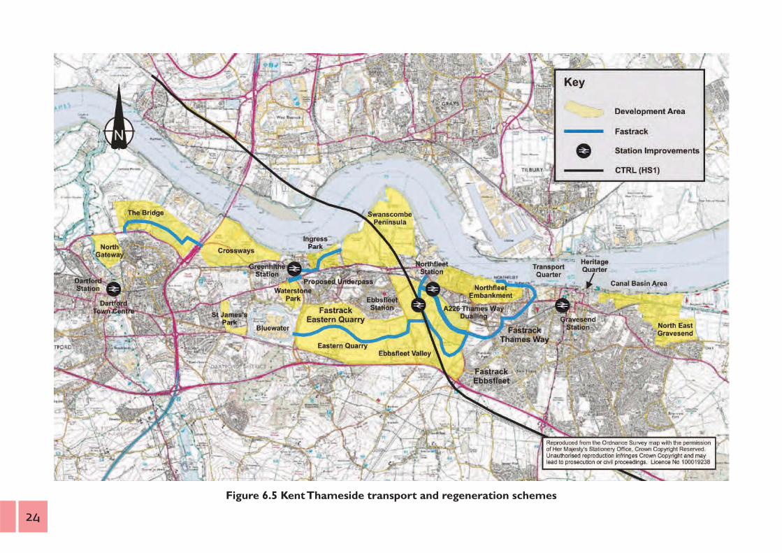
Figure 6.5 Kent Thameside transport and regeneration schemes
24
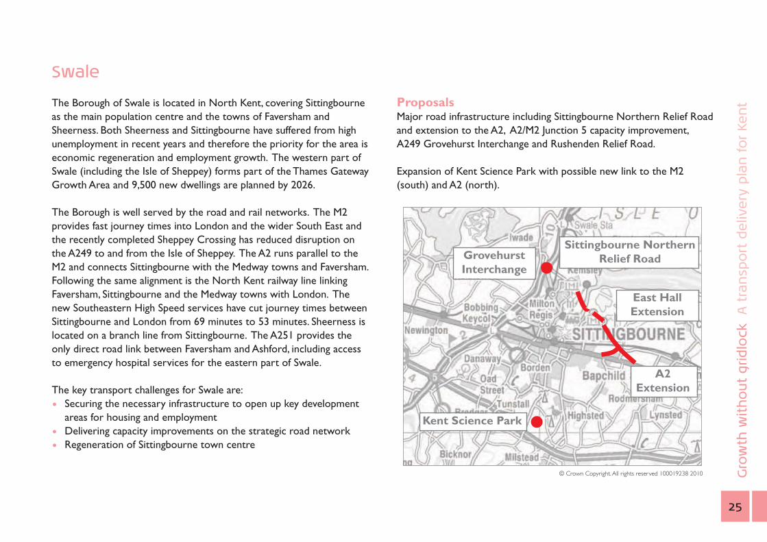
Swale
The Borough of Swale is located in North Kent, covering Sittingbourne as the main population centre and the towns of Faversham and Sheerness. Both Sheerness and Sittingbourne have suffered from high unemployment in recent years and therefore the priority for the area is economic regeneration and employment growth. The western part of Swale (including the Isle of Sheppey) forms part of the Thames Gateway Growth Area and 9,500 new dwellings are planned by 2026.
The Borough is well served by the road and rail networks. The M2 provides fast journey times into London and the wider South East and the recently completed Sheppey Crossing has reduced disruption on the A249 to and from the Isle of Sheppey. The A2 runs parallel to the M2 and connects Sittingbourne with the Medway towns and Faversham. Following the same alignment is the North Kent railway line linking Faversham, Sittingbourne and the Medway towns with London. The new Southeastern High Speed services have cut journey times between Sittingbourne and London from 69 minutes to 53 minutes. Sheerness is located on a branch line from Sittingbourne. The A251 provides the only direct road link between Faversham and Ashford, including access to emergency hospital services for the eastern part of Swale.
The key transport challenges for Swale are: 1 Securing the necessary infrastructure to open up key development
areas for housing and employment1 Delivering capacity improvements on the strategic road network1 Regeneration of Sittingbourne town centre
ProposalsMajor road infrastructure including Sittingbourne Northern Relief Roadand extension to the A2, A2/M2 Junction 5 capacity improvement,A249 Grovehurst Interchange and Rushenden Relief Road.
Expansion of Kent Science Park with possible new link to the M2(south) and A2 (north).
East HallExtension
GrovehurstInterchange
Sittingbourne NorthernRelief Road
A2Extension
© Crown Copyright.All rights reserved 100019238 2010
Kent Science Park
Gro
wth
without
grid
lock
A t
ransp
ort
deliv
ery
pla
n f
or
Kent
25
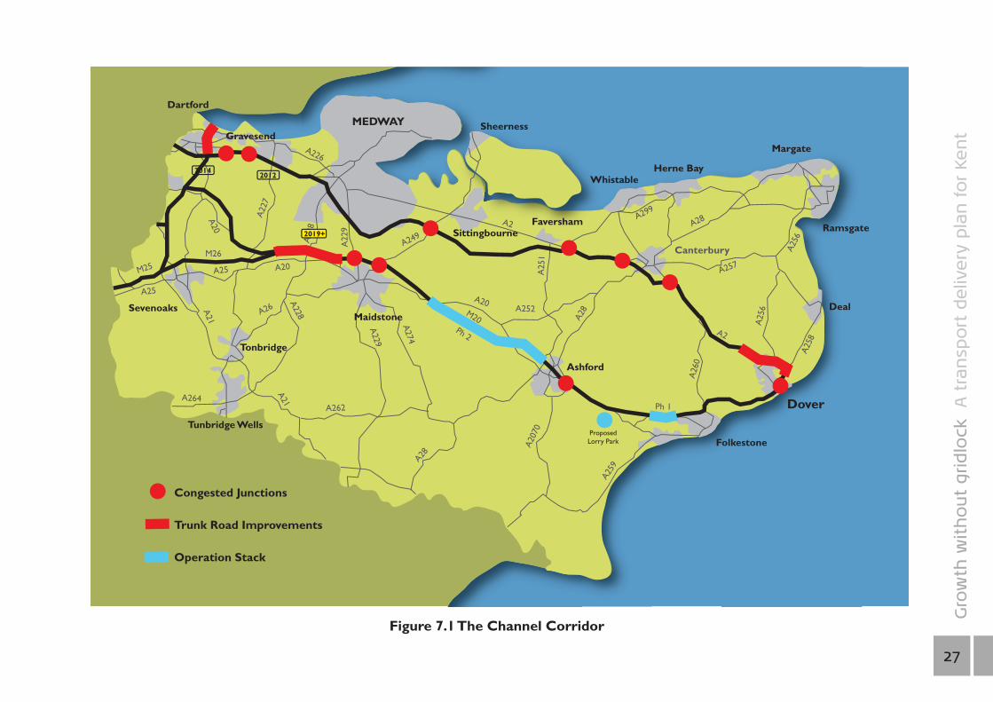
7. The Channel Corridor: relieving the pressure Issue: cross channel disruption when Operation Stack is
implemented costs the UK haulage industry £1m per day
Action: provision of a lorry park between junctions 10 and 11of the M20
Outcome: reduce delays to local traffic and problems linked to unsuitable HGV parking
Cost: £25-60m funded from foreign lorry charging scheme
Issue: predicted doubling of freight traffic through the portof Dover
Action: bifurcation of port traffic (Eastern Docks via M2/A2,Western Docks via M20)
Outcome: reduced congestion and pollution through Dover,regeneration of town centre
Cost: £440m-475m
There are few people in Kent who are unaffected by the County’s roleas an international corridor. We are fortunate to have convenientaccess to the Continent, whether for business or pleasure but we alsohave to suffer the traffic that uses this corridor. Road freight issignificant and one in four vehicles on the M20 between Maidstone andAshford is a lorry. When Operation Stack is in force, it makes us allrealise how fragile our transport network is. Dover is the largestpassenger ferry port in Northern Europe and handles more than half ofall the UK’s international ferry passengers. The town benefits from the
employment opportunities that the port brings but also suffers fromthe congestion, severance and air quality problems associated withqueuing traffic from the Eastern Docks.
There was a significant and continued increase in road freight throughthe Port of Dover and Channel Tunnel between the Tunnel’s opening in1994 and the recession in 2008. When the country’s economy picks upagain, continued growth, in line with GDP, is forecast to resume atDover and the Channel Tunnel. We therefore fully recognise theimportance of the Channel Corridor to “UK plc”.
Dover Western Docks ExpansionDover Harbour Board has developed a 30-year plan for the port so itcan accommodate the forecast increase in cross-channel traffic. A newferry terminal (T2) in the Western Docks could provide up to four newferry berths with the possibility of re-introducing rail freightconnections. Further improvements include a new marina in the outerharbour and related waterfront development, including expansion of thebusy cruise terminal. Since the new terminal at the Western Docks willtake some time to be implemented, interim measures to deal withtraffic continuing to use the Eastern Docks include revising the A20dock exit and upgrading Berth 5 to accommodate larger vessels. Theproposed expansion of Dover’s Western Docks will lead to thecreation of 6,000 jobs, with related productivity and GVA benefits.
M2/A2 Improvements at DoverFreight and passenger traffic through the Port of Dover is forecast togrow substantially over the next 30 years, placing further pressure onthe M20/A20 and M2/A2 corridors. The new Lower Thames Crossing is
26
MEDWAY
Faversham
Ashford
M25
A264
A21
A21
A26
M26
A20
A22
7
A22
8
A22
9
A226
A249 A2
A20
A20A25
A25
M20Ph 2
Ph 1
A20
70
A259
A274
A229
A228
A262 A28
A25
1
A252
A28
A299
A28
A257
A25
6
A25
6
A25
8
A2
A26
0
Dartford
Gravesend
Tonbridge
Tunbridge Wells
Maidstone
Herne Bay Whistable
Sheerness
Margate
Ramsgate
Deal
Canterbury
Dover
Folkestone
Sevenoaks
Sittingbourne
Congested Junctions
Trunk Road Improvements
Operation Stack
Pr oposed Lor r y Park
2014 2012
2019+
Gro
wth
without
grid
lock
A t
ransp
ort
deliv
ery
pla
n f
or
Kent
Figure 7.1 The Channel Corridor
27
part of a wider package of schemes proposed by KCC and its partnerswhich must be delivered collectively if we are to reap the maximumgrowth and productivity benefits.
One of the most important of these schemes is the bifurcation of traffictravelling to and from Dover. This would be made possible by theprovision of a Lower Thames Crossing between Chadwell andGravesend and would allow traffic heading for Dover’s Eastern Docksto be directed via the M2/A2, thereby relieving pressure on the M20.This would require improvements to the M2/A2 route including duallinga short length of the A2 north of the town between Lydden and theWhitfield roundabout. This is essential to maximise the developmentpotential of the Port of Dover and presents an opportunity to dealeffectively with strategic long distance lorry routing to the M11 and theMidlands. Bifurcation will also facilitate the growth of Whitfield,Ashfordand Maidstone by freeing up capacity on the M20.
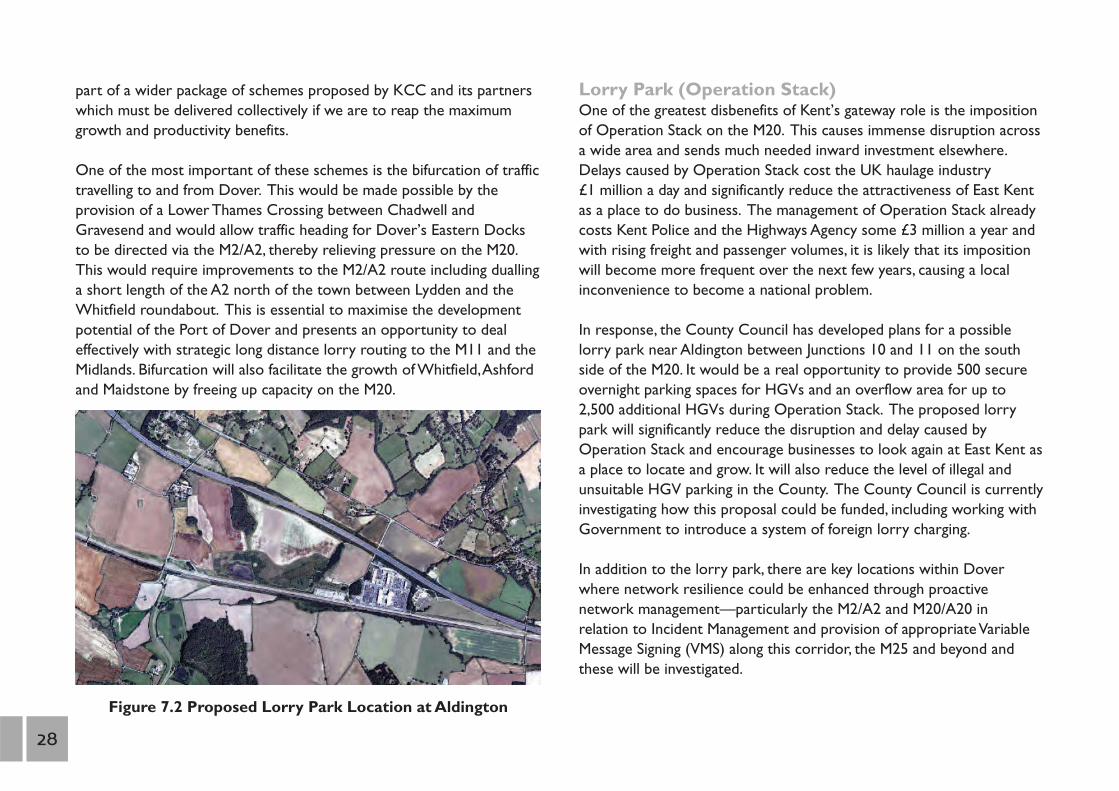
Figure 7.2 Proposed Lorry Park Location at Aldington
Lorry Park (Operation Stack)One of the greatest disbenefits of Kent’s gateway role is the impositionof Operation Stack on the M20. This causes immense disruption acrossa wide area and sends much needed inward investment elsewhere.Delays caused by Operation Stack cost the UK haulage industry £1 million a day and significantly reduce the attractiveness of East Kentas a place to do business. The management of Operation Stack alreadycosts Kent Police and the Highways Agency some £3 million a year andwith rising freight and passenger volumes, it is likely that its impositionwill become more frequent over the next few years, causing a localinconvenience to become a national problem.
In response, the County Council has developed plans for a possiblelorry park near Aldington between Junctions 10 and 11 on the southside of the M20. It would be a real opportunity to provide 500 secureovernight parking spaces for HGVs and an overflow area for up to2,500 additional HGVs during Operation Stack. The proposed lorrypark will significantly reduce the disruption and delay caused byOperation Stack and encourage businesses to look again at East Kent asa place to locate and grow. It will also reduce the level of illegal andunsuitable HGV parking in the County. The County Council is currentlyinvestigating how this proposal could be funded, including working withGovernment to introduce a system of foreign lorry charging.
In addition to the lorry park, there are key locations within Doverwhere network resilience could be enhanced through proactivenetwork management—particularly the M2/A2 and M20/A20 in relation to Incident Management and provision of appropriate VariableMessage Signing (VMS) along this corridor, the M25 and beyond andthese will be investigated.
28
Foreign Lorry ChargingThe County Council has set out proposals to introduce a charge forforeign lorries using Kent’s roads to contribute to the cost of the LowerThames Crossing, the Operation Stack lorry park and other infrastructureimprovements which will mitigate the impact of cross-Channel traffic.A charge would also help to level the playing field for UK hauliers vis-à-vis their foreign counterparts, many of which enter Britain with full fueltanks, having taken advantage of the lower rates of fuel duty on theContinent. They therefore make no contribution to the costs theyincur in this country through damage to roads, the release of emissionsand the exacerbation of congestion problems. KCC is delighted at theCoalition Government’s commitment, in its National InfrastructurePlan, to introduce a scheme of lorry charging and we will work with theDepartment for Transport to implement it as swiftly as possible.
Overnight Lorry ParksIn addition to Operation Stack, overnight lorries parking in residentialand commercial areas have a detrimental impact on Kent and itscommunities. KCC will lobby for the provision of overnight lorryparking and associated facilities at suitable sites adjacent to Kent'smotorway and trunk road network, including the possibility of usingPark and Ride sites for overnight lorry parking. We will also work withother agencies to reduce the occurrence of inappropriate lorry parkingon Kent's roads.
Quick Moveable Barrier (QMB) ExtensionThe Quick Moveable Barrier (QMB) can only cope with Phase One ofOperation Stack, holding some 400 lorries which, at peak times, can befilled within two hours. The Highways Agency is currently reviewing theperformance of the QMB and will recommend whether the schemeshould be expanded. We continue to press for the time taken to effectthe QMB to be significantly reduced.
EurotunnelThe Channel Tunnel offers a direct alternative to Dover for internationalcar and lorry movements, taking some 40% and 33% of the marketrespectively in 2008. Competition with the ferries has kept the costs ofcrossing the Channel relatively low and, together with the short andfrequent crossing, has meant that Kent attracts a high level of internationaltraffic. The Tunnel has good, direct access to and from the M20 but thebenefits of this are negated when there is major disruption in the Channeland Operation Stack is required. Theoretically, Eurotunnel couldoperate more shuttles which could relieve some of the pressure on Dover.
International Rail ServicesThe European Union’s liberalisation of international rail travel in 2010enables train operating companies to run services in competition withEurostar between London and the Continent. The German operator,Deutsche Bahn, is the first to receive permission to do so and intendsto commence services to Amsterdam and Frankfurt via Brussels inDecember 2013. KCC’s priority is to ensure that Ebbsfleet and Ashfordcontinue to benefit from frequent services to a range of northernEuropean destinations and we will lobby Eurostar and Deutsche Bahnto include a Kent station stop on as many of their services as possible.
Road/RailTerminalsWe are generally supportive of strategic road/rail terminals if they areplaced in the right location and will genuinely transfer freight from roadto rail.As a result, the County Council supported the proposedredevelopment of a 64 hectare site at Howbury Park in Erith as it iswell located close to London and the M25. However, the CountyCouncil strongly opposed the proposals for the Kent InternationalGateway (KIG), located to the east of Maidstone as, amongst otherthings, it was over 20 miles from the M25 and would not have relievedthe most congested western part of the M20 of lorry traffic.
Gro
wth
without
grid
lock
A t
ransp
ort
deliv
ery
pla
n f
or
Kent
29
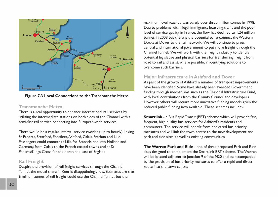
Figure 7.3 Local Connections to the Transmanche Metro
London N
0 50km
Canterbury (22 mins)
Stansted Airport (66 mins)
Southend (50 mins)
Hastings (42 mins)
Thanet (43 mins)
Dunkerque (50 mins)
Boulogne (38 mins)
Kortrijk (30 mins)
Douai (27 mins)
Aprrox Scale
Arras (41 mins)
Dover (32 mins)
Folkestone (20 mins)
Ebbsfleet
Ashford Calais
Frethun
To Brussels
To Paris
Lille
Stratford
Transmanche MetroThere is a real opportunity to enhance international rail services byutilising the intermediate stations on both sides of the Channel with asemi-fast rail service connecting into European-wide services.
There would be a regular interval service (working up to hourly) linkingSt Pancras, Stratford, Ebbsfleet,Ashford, Calais-Frethun and Lille.Passengers could connect at Lille for Brussels and into Holland andGermany, from Calais to the French coastal towns and at StPancras/Kings Cross for the north and east of England.
Rail FreightDespite the provision of rail freight services through the ChannelTunnel, the modal share in Kent is disappointingly low. Estimates are that6 million tonnes of rail freight could use the Channel Tunnel, but the
maximum level reached was barely over three million tonnes in 1998.Due to problems with illegal immigrants boarding trains and the poorlevel of service quality in France, the flow has declined to 1.24 milliontonnes in 2008 but there is the potential to re-connect the WesternDocks at Dover to the rail network. We will continue to presscentral and international government to put more freight through theChannel Tunnel. We will work with the freight industry to identifypotential legislative and physical barriers for transferring freight fromroad to rail and assist, where possible, in identifying solutions toovercome such barriers.
Major Infrastructure in Ashford and DoverAs part of the growth of Ashford, a number of transport improvementshave been identified. Some have already been awarded Governmentfunding through mechanisms such as the Regional Infrastructure Fund,with local contributions from the County Council and developers.However others will require more innovative funding models given thereduced public funding now available. These schemes include:-
Smartlink - a Bus Rapid Transit (BRT) scheme which will provide fast,frequent, high quality bus services for Ashford’s residents andcommuters. The service will benefit from dedicated bus prioritymeasures and will link the town centre to the new development andpark and ride sites, as well as existing communities.
The Warren Park and Ride - one of three proposed Park and Ridesites designed to complement the Smartlink BRT scheme. The Warrenwill be located adjacent to Junction 9 of the M20 and be accompaniedby the provision of bus priority measures to offer a rapid and directroute into the town centre;
30

Victoria Way - a new route to the south of the town centre whichwill link Beaver Road and the A28 Chart Road. Work is currentlyunderway on this scheme, which is due for completion in Spring 2011;
M20 Junction 9 and Drovers Roundabout - which will improveaccess to the town; particularly the Eureka Park business area andresidential developments such as Repton Park. The scheme will includethe introduction of traffic signals, the widening of approach roads andthe construction of a new footbridge over the M20. Work is currentlyin progress and will be completed in Spring 2011;
M20 Junction 10A - providing the necessary highway capacity toserve and support the new development sites to the south and eastof Ashford;
Learning Link - a north-south cycling/walking route linking a series ofeducational establishments;
A28 Kennington/Bybrook Corridor - cycling, pedestrian and busimprovements;
Roman Way Corridor - new link road;
Ashford International Station Improvements - comprising a newstation forecourt and public space to complement the recentlycompleted works to the ticket hall. The scheme will include arevitalised bus and taxi interchange, extensive cycle parking, theprovision of additional seating and landscaping;
Dover Bus RapidTransit - The Dover Bus Rapid Transit (BRT)scheme is a proposed service connecting Whitfield to Dover TownCentre and is part of the masterplan for 5,750 new homes at Whitfield.
It is planned to run on a dedicated route through the variousdevelopment sites in Whitfield and the Connaught Barracks, linking tothe town centre, Dover Priory railway station and the St Jamesregeneration area, with a possible extension to a Park and Ride site at Farthingloe. KCC and Dover District Council are currently preparing a detailed business case for the scheme and identifyingsuitable funding options;
South East Maidstone Strategic Link (SEMSL) - MaidstoneBorough Council has identified, through its Local DevelopmentFramework, the potential for new development to the south east of thetown. This could require a more direct route from the A274, servingthe commercial area around Parkwood and new development at theA20/M20 Junction 8 which would also act as a bypass to Leeds andLangley. The SEMSL does not appear to be affordable by conventionalfunding, and would require new sources of funding currently emergingfrom Government, such as the New Homes Bonus.
Gro
wth
without
grid
lock
A t
ransp
ort
deliv
ery
pla
n f
or
Kent
31

Ashford
The strategic position of Ashford on the Channel corridor has meantthat the town has always been a major transport hub. The M20 runsthrough the town and access is provided via junctions 9 and 10.Ashfordalso became a railway town, being the junction of five lines to Hastings,Folkestone, Canterbury, Maidstone and Tonbridge and is also served byHigh Speed One with an international railway station.Ashford hasbenefited from reduced journey times when Southeastern High Speedservices commenced in December 2009, with the quickest journey timeto London cut to 37 minutes from 84 minutes.
Because of its strategic location, good transport links and a generally flattopography,Ashford is one of the South East region’s four designatedGrowth Areas, with the capacity to provide an additional 31,000 homesand 28,000 jobs over the period 2001 to 2031. This equals a doubling inthe number of households within the town centre area by 2031. It isplanned for Ashford to develop as an office, research and business nodeproviding market growth for East Kent and an opportunity for largeinvestments that require an expanding workforce.
The key transport challenges for Ashford are:1 Securing road access from development sites to the M201 Developing a high quality public transport network to connect the
growth areas with the town centre, the international station andother key locations
1 Providing a choice of transport modes for residents1 Creating a high quality public realm in the town centre
ProposalsSmartlink Bus Rapid Transit system connecting the growth areas andout-of-town Park and Ride sites with the town centre, internationalstation and complementary expanded bus network and cycling facilities.
Green spaces and the existing road network incorporating walking andcycling routes as well as promotion of Ashford as a “cycling town”.
Learning LinkCorridor
A28 Kennington/BybrookCorridor
Proposed SmartlinkProposed Park &Ride site
Link Road
VictoriaWay
RomanWay
J10A
P&R
P&R
P&R
© Crown Copyright.All rights reserved 100019238 2010
32

Dover
Dover is best known as the UK’s gateway to the Continent, being thecountry’s busiest ferry port. This can often lead to traffic congestionalong the A20 Townwall Street, causing pollution and severance betweenthe town and seafront. This is exacerbated when disruption causescross-Channel services to be suspended and Operation Stack is putinto operation. The most direct rail service to London is via theFolkestone line which connects with services from Ashford. There arealso lines that connect to the north Kent line via Canterbury and acoastal line to Deal, Sandwich and Thanet. Southeastern High Speedservices were introduced in December 2009, reducing the journey timefrom 116 minutes to 67 minutes. This is starting to help create thefoundations for a transformation in the economic geography of Dover.It is anticipated that further improvements in journey time togetherwith additional parking and at Dover Priory station will be realised tosupport the recent public realm works.
The key transport challenges for Dover are:1 Increasing cross-Channel freight traffic using the port causing
congestion and pollution on the A20 and severance1 Delivering 10-14,000 new homes as part of the town’s Growth Point
status, which will require improvements to the A21 Providing better accessibility to the town centre and railway station
to maximise the benefits of Southeastern High Speed services1 Regenerating the old colliery sites around Aylesham and Snowdown
and supporting growth in the Sandwich corridor1 Reduce HS1 journey times from Dover Priory to London to under
an hour
ProposalsExpansion of Western Docks, seafront development and related accessimprovements to the A20 with bifurcation of port traffic via M20/A20(Western Docks) and M2/A2 (Eastern Docks).
Dualling of the A2 from Lydden to Dover.
Bus Rapid Transit (BRT) system between Whitfield, Dover town centreand the railway station complementing an enhanced bus network.
West WhitfieldGrowth Area
East WhitfieldGrowth Area
Potential Routeof Dover BRT
Dover Priory
Port Proposals
© Crown Copyright.All rights reserved 100019238 2010
Gro
wth
without
grid
lock
A t
ransp
ort
deliv
ery
pla
n f
or
Kent
33
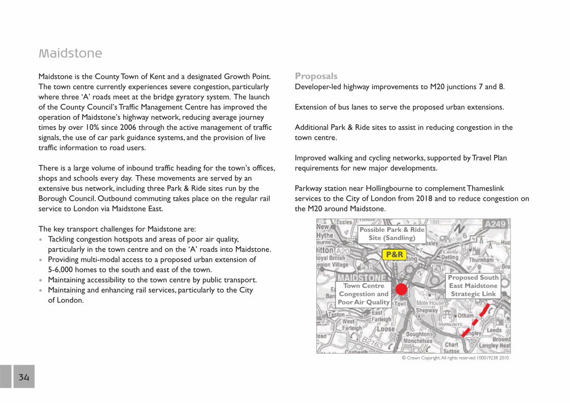
Maidstone
Maidstone is the County Town of Kent and a designated Growth Point. The town centre currently experiences severe congestion, particularly where three ‘A’ roads meet at the bridge gyratory system. The launch of the County Council’s Traffic Management Centre has improved the operation of Maidstone’s highway network, reducing average journey times by over 10% since 2006 through the active management of traffic signals, the use of car park guidance systems, and the provision of live traffic information to road users.
There is a large volume of inbound traffic heading for the town’s offices, shops and schools every day. These movements are served by an extensive bus network, including three Park & Ride sites run by the Borough Council. Outbound commuting takes place on the regular rail service to London via Maidstone East.
The key transport challenges for Maidstone are: 1 Tackling congestion hotspots and areas of poor air quality,
particularly in the town centre and on the ‘A’ roads into Maidstone.1 Providing multi-modal access to a proposed urban extension of
5-6,000 homes to the south and east of the town.1 Maintaining accessibility to the town centre by public transport.1 Maintaining and enhancing rail services, particularly to the City
of London.
ProposalsDeveloper-led highway improvements to M20 junctions 7 and 8.
Extension of bus lanes to serve the proposed urban extensions.
Additional Park & Ride sites to assist in reducing congestion in thetown centre.
Improved walking and cycling networks, supported by Travel Planrequirements for new major developments.
Parkway station near Hollingbourne to complement Thameslinkservices to the City of London from 2018 and to reduce congestion onthe M20 around Maidstone.
Proposed SouthEast MaidstoneStrategic Link
Town CentreCongestion andPoor Air Quality
Possible Park & RideSite (Sandling)
© Crown Copyright.All rights reserved 100019238 2010
P&R
34

Shepway
Shepway is located within the Channel corridor, hence the maintransport issues relate to the impact of international traffic. Folkestoneis the main urban, retail and commercial centre in Shepway with Hytheand Sandgate located along the coast, Hawkinge, which lies on theNorth Downs, and various towns and villages dotted around theRomney Marsh. Like many of the coastal towns in Kent, Folkestone hassuffered from several decades of economic decline, due mainly to theloss of seaside trade. It has also experienced the withdrawal of cross-Channel ferry services as a result of competition from the ChannelTunnel and the Port of Dover. Furthermore, the town centre is facingincreased competition from neighbouring shopping centres, withleakage of trade to Canterbury and Ashford.
Folkestone has good road access to London and the wider South Eastvia the M20, the A20 and the A259, and regular rail services to Londonand Dover. The town has benefited from the introduction ofSoutheastern High Speed services in December 2009, with journeytimes having been cut from 101 minutes to 57 minutes. The ChannelTunnel facility is located to the north of Folkestone at Cheriton.
The key transport challenges for Folkestone are:1 The impact of Operation Stack on the local road network1 Maximising the benefits of Southeastern High Speed services and
managing the impact on local journey patterns1 Supporting the regeneration proposals for the seafront as part of the
Folkestone Harbour and Seafront Masterplan, with better access to the seafront from the town centre
1 Providing public transport access to and from proposeddevelopment sites in West Hythe, Lympne and Shorncliffe.
ProposalsParkway station at Westenhanger and improvements to FolkestoneWest station.
Improved public transport to development sites, existing inter-urbanroutes and expansion of the urban bus network.
FolkestoneWest Station
Harbour andSea Front
© Crown Copyright.All rights reserved 100019238 2010
Gro
wth
without
grid
lock
A t
ransp
ort
deliv
ery
pla
n f
or
Kent
35
8. West Kent: cutting congestion along the A21 corridor Issue: congestion and delay on A21 near Tunbridge Wells and
Tonbridge, poor accessibility to Hastings
Action: dualling of A21 between Tonbridge and Pembury
Outcome: improved journey times and reduced congestion forbusinesses, improved safety for road users
Cost: est. £45m funded from National Roads Programme
The West Kent area comprises the districts of Tunbridge Wells,Tonbridge & Malling and Sevenoaks and features a number of mediumsized towns including Swanley, Sevenoaks,Tonbridge and Tunbridge Wells,interspersed with smaller settlements and tracts of open countryside. Itis a very attractive area in which to live and work and is generally moreprosperous than other parts of Kent thanks to its close proximity toLondon. However, economic growth in West Kent has increasinglylagged behind many other areas in the South East in recent years andthe area’s GVA per capita is only 74% of the South East average.
One of the key reasons for West Kent’s declining economic positionrelative to other parts of Kent and the wider South East is its poortransport connectivity; particularly peak time congestion on inter-urbanroutes such as the A21,A26 and A228. The area’s traditional railconnectivity advantage to London has also been diminished by thecommencement of High Speed rail services from North and East Kentto London. These have made commuter journey times from Ashford,Folkestone and Canterbury comparable with those to Tonbridge andTunbridge Wells, and significantly better than those to Maidstone. Thissituation requires urgent action if West Kent is to regain its previouseconomic strength.
Devolving Highways Agency budgets and powers to local transportauthorities would provide a cheaper and faster way of deliveringstrategic road infrastructure. The Kent economy has sufferedrepeatedly from delays to Highways Agency projects, including thedualling of the A21 between Tonbridge and Pembury.Although work wasfinally due to start on this scheme in 2011, it has now been delayedonce more beyond 2015 pending further consideration by theDepartment for Transport and will therefore not be completed in timefor the opening of the new Pembury Hospital. We believe that thescheme can be delivered for less than half its current costthrough local project management and procurement. TheCoalition Government has agreed to work with us to investigate thebenefits of this approach and we will progress these discussionsimmediately. We also want to see further improvements to the A21 tosupport the regeneration of Hastings.
36
We will continue to support the A21 Reference Group of MPs, CouncilLeaders and heads of public services which is pressing for the urgentdualling of the A21 between Tonbridge and Pembury and Kippings Crossto Lamberhurst. These measures will support business growth,regeneration and access to services in the A21 corridor fromSevenoaks through to Hastings.
The loss of direct rail services between the City of London, Maidstoneand West Malling has forced commuters from these areas to travel byroad to Tonbridge, Hildenborough and Sevenoaks, which have retainedtheir Cannon Street services. This has in turn added to existingovercrowding problems on rail services to and from Tonbridge.
Southeastern has plans to improve the service on the Tonbridge-Hastings line when the new Thameslink programme commences in2018. The Hastings trains would join and divide at Tonbridge, providingfast and slow portions along the line between Tonbridge and Hastings.This would improve journey times for rail passengers from principalstations on the line, while still providing a slower service for the smaller stations.
Another key aspiration is the re-introduction of direct servicesbetween Kent and Gatwick Airport, following the cessation of servicesfrom Tunbridge Wells and Tonbridge via Redhill in 2008. A new servicewould need to be demonstrated as viable and economical in time forthe renewal of the existing Southern franchise in 2015.
Colts HillThe A228 Colts Hill bypass scheme is required to complete a highstandard and safe route between the M20 and the A21 and links to theA21 Tonbridge to Pembury dualling proposal. The A228 at Colts Hillcurrently suffers from poor visibility and concealed entrances
which contribute to its poor accident record and severe peak time congestion.
The scheme would incorporate a single carriageway bypass of Colts Hillvillage, with a climbing lane in the southbound direction. The proposedbypass would address these issues, whilst also enhancing access to thenew Pembury Hospital from Maidstone. This is particularly importantgiven the planned transfer of a number of medical units to Pemburyfrom Maidstone Hospital when the site becomes fully operational in2011. The scheme would also make a significant contribution to theplanned improvement of bus services on the Maidstone to TunbridgeWells corridor and assist with sub-regional integration. KCC hassubmitted the scheme for Central Government funding on a number ofoccasions since 2003; however it has so far been unsuccessful.
Gro
wth
without
grid
lock
A t
ransp
ort
deliv
ery
pla
n f
or
Kent
37
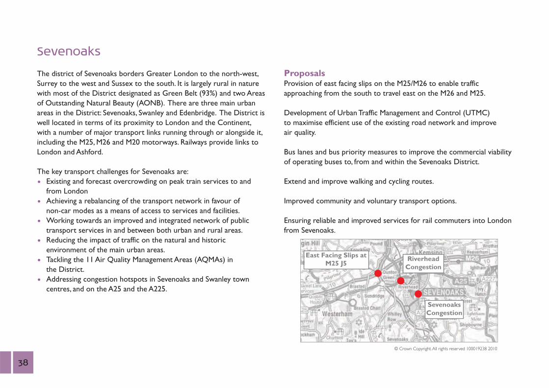
Sevenoaks
The district of Sevenoaks borders Greater London to the north-west,Surrey to the west and Sussex to the south. It is largely rural in naturewith most of the District designated as Green Belt (93%) and two Areasof Outstanding Natural Beauty (AONB). There are three main urbanareas in the District: Sevenoaks, Swanley and Edenbridge. The District iswell located in terms of its proximity to London and the Continent,with a number of major transport links running through or alongside it,including the M25, M26 and M20 motorways. Railways provide links toLondon and Ashford.
The key transport challenges for Sevenoaks are:1 Existing and forecast overcrowding on peak train services to and
from London1 Achieving a rebalancing of the transport network in favour of
non-car modes as a means of access to services and facilities. 1 Working towards an improved and integrated network of public
transport services in and between both urban and rural areas. 1 Reducing the impact of traffic on the natural and historic
environment of the main urban areas.1 Tackling the 11 Air Quality Management Areas (AQMAs) in
the District.1 Addressing congestion hotspots in Sevenoaks and Swanley town
centres, and on the A25 and the A225.
ProposalsProvision of east facing slips on the M25/M26 to enable trafficapproaching from the south to travel east on the M26 and M25.
Development of Urban Traffic Management and Control (UTMC)to maximise efficient use of the existing road network and improve air quality.
Bus lanes and bus priority measures to improve the commercial viabilityof operating buses to, from and within the Sevenoaks District.
Extend and improve walking and cycling routes.
Improved community and voluntary transport options.
Ensuring reliable and improved services for rail commuters into Londonfrom Sevenoaks.
East Facing Slips atM25 J5
RiverheadCongestion
SevenoaksCongestion
© Crown Copyright.All rights reserved 100019238 2010
38
Tonbridge and Malling
The Borough of Tonbridge and Malling has a population ofapproximately 112,000 and covers an area of just over 24,000 hectares.The Borough does not have a single urban focus but is comprised of anumber of diverse, contrasting settlements and neighbourhoods.A considerable area of the Borough is rural in character. The M20motorway, a key national link, cuts through the middle of the Boroughand has important implications for traffic patterns on the local network.
Key transport challenges for Tonbridge & Malling are:1 Dealing with the transport implications of the range of
developments in the Borough, particularly in the Medway Valley andin central Tonbridge.
1 Improving air quality in a number of declared AQMAs arising fromtraffic-related factors, including a long stretch of the A20 andTonbridge town centre.
1 Enhancing station facilities and rail connections to the City of London on the West Malling/Maidstone East Line and tackling overcrowding on the Tonbridge line.
1 Improving transport interchange at Tonbridge and West Malling stations and addressing the lack of parking at West Malling andHildenborough stations.
1 Reinstating direct rail services between the Borough and Gatwick Airport on the Tonbridge-Redhill Line.
1 Minimising the adverse impacts of HGV traffic, including overnight parking
1 Mitigating the impacts of traffic on the A25 corridor through Platt,Borough Green and Ightham.
ProposalsCoordinated implementation of transport requirements arising fromdevelopments in the Medway Valley, including new bus servicessupported by bus priority measures – focussed on the A20 corridor.
Construction of a bypass at Borough Green.
Construction of the London Road-Hadlow Road link in Tonbridge.
Urban Traffic Management and Control system for Tonbridge.
Implement Action Plan to deal with AQMAs.
Work with Network Rail and the Train Operating Companies in thearea to enhance opportunities for transport interchange at stations andimprove services, particularly to the City of London, with particularfocus on the service specification for the next Integrated KentFranchise period beyond 2014.
A228 Corridor Improvements – including at Kent Street, Snodlandbypass and at Colts Hill in neighbouring Tunbridge Wells Borough - torelieve the A26 corridor.
Gro
wth
without
grid
lock
A t
ransp
ort
deliv
ery
pla
n f
or
Kent
39

Tunbridge Wells
Tunbridge Wells Borough is an area of 326 square kilometres borderingSevenoaks,Tonbridge & Malling, Maidstone and Ashford in Kent; andRother and Wealden in East Sussex. The town of Royal Tunbridge Wellsis the main urban centre in the district, providing social, cultural andeconomic opportunities. Southborough, Paddock Wood, Cranbrook,Hawkhurst and 17 villages serve the extensive rural population.
The Borough benefits from a good rail service to Tonbridge, Sevenoaksand London, a bus network that covers both the urban and rural areasand good provision of car parking facilities within the town centres,many of which are free in the more rural towns.There are very high levels of car ownership and use within theBorough, resulting in congestion and poor air quality issues.Infrastructure improvements and increased use of high quality publictransport, cycling and walking facilities have already started to reducetraffic congestion, and this is a key area for continued improvement inthe future.
The key transport challenges for Tunbridge Wells are:1 Addressing congestion hotspots on the A21 between Tonbridge
and Tunbridge Wells; on the Pembury Road; within the North Farm/Longfield Road industrial area; and on the A26 within Tunbridge Wells and Southborough.
1 Tackling AQMAs across the district.1 Reducing the impact of traffic on the natural and historic
environment of the main urban areas.1 Ensuring optimum accessibility to the new Pembury Hospital by a
range of travel options including the proposed integrated bus and railnetworks, cycling and the car
40
1 Accommodating development pressures resulting from the Borough’s location in the commuter belt in a sustainable way.
ProposalsDevelopment of UTMC to maximise efficient use of the existing road network.
Implement Park & Ride to help tackle congestion and poor air quality inRoyal Tunbridge Wells town centre, including complementary bus lanesand bus priority measures.
A21 Pembury to Tonbridge dualling to improve access to the newPembury Hospital and the North Farm Retail Park.
A21 improvements between Kippings Cross and Lamberhurst andbetween Lamberhurst and Flimwell.
Extend and improve walking and cycling routes.
Ensuring reliable and improved rail services for commuters into Londonfrom Tunbridge Wells.
A228 corridor improvement at Colts Hill.

HS1 Quickest JourneyTimes to London from:
Pre HS1(mins)
Post HS1(mins)
Ashford 84 37
Folkestone Central 101 57
Dover 116 67
Ramsgate 129 80
Canterbury 110 56
Gravesend 57 22
9. East Kent: radical solutions needed Issue: poor accessibility to East Kent leading to high
unemployment and social disadvantage in East Kent
Action: provision of a Thanet Parkway station to improve employment opportunities in Thanet andthroughout East Kent and improved line speedsbetween Ashford and Ramsgate
Outcome: ~1,000 jobs per million passengers at KIA, rising to 6,000 jobs by 2033 increased attractiveness of EastKent to employers, reduced journey times to/fromThanet, reduction in welfare costs
Cost: ~£10m for Parkway station and up to £50m for line speed enhancements
East Kent is made up of the Districts of Canterbury, Dover, Shepwayand Thanet. East Kent is peripheral to the rest of the UK and, as such,suffers greater deprivation and social problems than West Kent and thesouth-east region generally. The coastal area has experienced thecumulative effects of a declining ferry port industry as a consequence ofthe Channel Tunnel, the aftermath of the closure of the East Kent coal-field and the loss of the holiday trade. This peripherality discouragesmajor employers from locating in the area and has resulted in an over-reliance on jobs in the education, pharmaceutical and port-relatedsectors.Away from the coast, Canterbury is the predominant retail,cultural and educational centre and its priority is to protect its historicfabric while encouraging economic growth.
Economic regeneration is the key priority in East Kent and theregeneration potential of East Kent will be dependent upon improvingthe overall level of accessibility to this peripheral location to the rest ofthe UK.
Enhancing the Benefits of High Speed RailOn 13th December 2009, Southeastern High Speed servicescommenced. These services have dramatically cut rail journey times toEbbsfleet,Ashford and other areas of Kent to Stratford (for Docklands),St Pancras and the north of the country. The improved journey timeswill have a significant impact and act as the catalyst to regenerate partsof the County, making them very attractive places to live, work and visit.The High Speed services provide a real opportunity to promotetourism, bringing Kent’s attractions closer to visitors from London.
Gro
wth
without
grid
lock
A t
ransp
ort
deliv
ery
pla
n f
or
Kent
41

Further improvements are required to the rail network in East Kent tomaximise the benefits of High Speed services. Journey times on theconventional rail network beyond Ebbsfleet and Ashford are still lengthyand access to a number of rail stations is poor. We are working closelywith Network Rail and Southeastern to ensure that the necessaryimprovements are implemented.
Thanet Parkway Station/Kent International Airport(KIA)Thanet is one of England’s most disadvantaged districts, with highunemployment rates and a total welfare bill of £180 million a year. Thearea is overly dependent on public sector and seasonal employment andhas not benefitted fully from the launch of High Speed domestic railservices to London.
Kent International Airport (Manston) has the potential to develop into aregional airport and become one of the largest single generators ofeconomic activity in the County. The airport predicts that it will servearound 5 million passengers and cater for 400,000 tonnes of freight by2033.This could generate over 2,800 jobs by 2018 and 6,000 jobs by2033 in a range of employment sectors, offering a huge boost to theeconomy of East Kent through new employment opportunities arisingfrom the growth of the Manston and Eurokent Business Parks. Its futuregrowth is dependent upon and will be driven by the displacement oftraffic from other South East airports as they begin to operate atcapacity due to continuing growth. We will continue to promote thereal opportunities at Manston and press hard for enhanced access byhigh speed rail services to facilitate the economic benefits.
The KIA draft masterplan proposes major expansion supported by aparkway station with High Speed rail services from London, serving notjust the airport but also the local area. This will be located near to the
perimeter of KIA, with improved bus links and local road improvementsto link to the A299.
Many of the existing rail stations in Thanet and part of Dover Districtare difficult to reach by sustainable transport and offer limited carparking and development opportunities. This causes some commutersto travel significantly longer distances by car to access stations withbetter parking facilities. Initial feasibility analysis by the County Councilsuggests that there is consequently a strong business case for a ThanetParkway station close to KIA and we will shortly be submitting a bidwith Network Rail to the Government’s Regional Growth Fund fora contribution to the capital cost of the project. We will also investigate the feasibility of developing parkway stations at Maidstoneand Westenhanger.
Figure 9.1 High Speed Journey Savings to ProposedThanet Parkway
Canterbury
Ashford International
ProposedThanet Parkway
Ramsgate
76 64
56 54
Existing High Speed Times
Potential High Speed Times
56 54
42
Ashford to Ramsgate Line Speed Improvements The County Council and Network Rail recently commissioned a studyto identify potential line speed improvements between AshfordInternational and Ramsgate. The study found that by increasing linespeeds from the current maximum of 70mph to the 85mph allowed forby current signalling, and eliminating permanent speed restrictions atthree locations, running times between Ashford and Ramsgate could bereduced from 36 minutes to a theoretical minimum of 26 minutes. Thiswould see journey times between St Pancras and the proposed ThanetParkway drop to approximately an hour, which would provide asignificant boost to tourism and the regeneration of the area and alsoenhance access to private sector employment at Ashford and Ebbsfleet.Network Rail now intends to prepare a full business case for thescheme, which is currently scheduled for implementation in 2014.
Ashford to Dover Line Speed ImprovementsKCC is also working with Network Rail to identify further line speedimprovements between Ashford and Dover. The aspiration is to reducejourney times between London and Dover Priory to less than an hour,which is vital to improve the attractiveness of the town to businessesand new residents.
East Kent Access Phase 2The East Kent Access scheme aims to improve road access between theA299 Thanet Way and the Pfizer site near Sandwich. Phase 1, which wascompleted in 2007, saw the A256 become a dual carriageway aroundthe Pfizer site as far as the disused Richborough power station. Phase 2is currently under construction and involves the improvement of theA299 from Mount Pleasant roundabout to Lord of the Manor; and theA256 from Lord of the Manor back to Ebbsfleet Lane. This scheme willopen up development land in this area and strengthen Pfizer’s role asthe main employer for the area. Crucially, the improved road access will
have significant regeneration benefits for the area and provide acontinuous dual carriageway from London to Thanet.
RamsgateThe Port of Ramsgate is well connected to the national road networkvia the A299 and M2 and is served by a modern port access road thatavoids the need to travel through heavily built up areas. A car andfreight ferry operates to Ostend and the port has the potential tooperate up to twice as many ferries without any additionalinfrastructure, complementing the increased capacity planned for Dover.
Ramsgate is being used in connection with the operation of the ThanetOffshore Wind Farm, a 100 turbine development 8 miles off the north-east Kent coast and is the base for the project’s operations andmaintenance centre. The London Array project is a much largerdevelopment of 341 wind turbines midway out in the Thames Estuarywith an investment value of £3 billion. The London Array wind farm isalso planning to use the port as it gears up for offshore constructionfrom 2011 and as a base for its future operations and maintenance.
Ramsgate has the only royal harbour in the UK and its award-winningmarina offers an excellent range of facilities with significant potential toboost the local economy from the sailing market in London, the southeast and the near continent.
Sustainable Links to High Speed StationsWe will continue with the award-winning work of integrating both theproposed parkway stations and existing high speed stations with the busnetwork, walking and cycling routes and support these with securecycle parking, information and other facilities.
Gro
wth
without
grid
lock
A t
ransp
ort
deliv
ery
pla
n f
or
Kent
43

Ashford to Hastings Line Speed ImprovementsThe elimination of speed restrictions on the Ashford to Hastings linewould greatly enhance travel between the two towns and toemployment in the Thames Gateway and London. This has the potentialto regenerate both the Romney Marsh area and Hastings in East Sussex.Network Rail is currently preparing the business case for the necessaryimprovement works which are scheduled for implementation in 2014.
London Ashford Airport (LAA)London Ashford Airport is an international airport located on theRomney Marsh near Lydd, close to the border with East Sussex. Itwas purpose built as a civilian airfield in the 1950s, and in recentyears, over £20 million has been spent developing and upgrading theairport’s facilities.
The airport has plans to extend its runway and build new terminalfacilities with the ability to provide 500,000 passenger movements by2015, capitalising on the growing passenger preference for using aregional airport and reducing surface transport times and costs.Additionally 75% of all air transport movements in the UK are in asouth-easterly direction, therefore Lydd brings additional benefits bybeing the most south-easterly UK airport. LAA is keen to utilise theexisting rail connection between Hastings and Ashford by improvingaccess to Appledore Station, and to better integrate with the busnetwork when demand enables sustained economic operations.
44
Canterbury
The city of Canterbury is the predominant retail, cultural and educational centre within East Kent and a principal focus for service industries. It is identified as a Regional Hub in the South East Plan. The city depends on a large net inflow of commuters to support the level of jobs in the area as well as an influx of secondary school children and students in higher education.Around 160,000 vehicles per day travel to and from Canterbury along the nine ‘A’ and ‘B’ roads that converge on the city.Although the city is bypassed to the south-west by the A2, the highway network is under acute pressure and, as a result, Canterbury suffers from significant congestion and poor air quality, especially on the inner ring road and radial routes. This congestion would be significantly worse without the three Park & Ride sites that have been used by over one million passengers every year since 2003. There are two railway stations which serve the city and Southeastern High Speed services commenced at the Canterbury West station in December 2009, cutting the journey time to London from approximately 90 minutes to 56 minutes.
The Canterbury District includes the coastal towns of Whitstable and Herne Bay. The transport priority for Whitstable is to reduce traffic delays in the main shopping streets and, for Herne Bay, to reduce the amount of out-commuting through regeneration of the town centre.
The key transport challenges for Canterbury are: 1 Reducing congestion and improving air quality, particularly along the
A28 and the ring road1 Linking transport investment and infrastructure improvements with
development plan priorities and strategic development allocations1 Reducing the impact of traffic on the historic environment by
increasing transport choice and reducing car dependency and the need to travel, especially during the peak hours
1 Improving the integration of different modes of travel attransport hubs
ProposalsProvision of A2 slip roads and a new interchange near Bridge.
Increase Park & Ride provision - in particular the provision of a site to serve the A2 north-western approach and reduce the number of city centre car parking spaces.
Development of Urban Traffic Management and Control (UTMC) to maximise efficient use of the existing road network.
Bus improvements and priority measures to improve the speed, reliability and frequency of services .
Extend and improve walking and cycling routes.
A relief road through Wincheap and suitable junctions with the A28.
Improvements in and around Canterbury West railway station to maximise the benefits of Southeastern High Speed services.
Gro
wth
without
grid
lock
A t
ransp
ort
deliv
ery
pla
n f
or
Kent
45
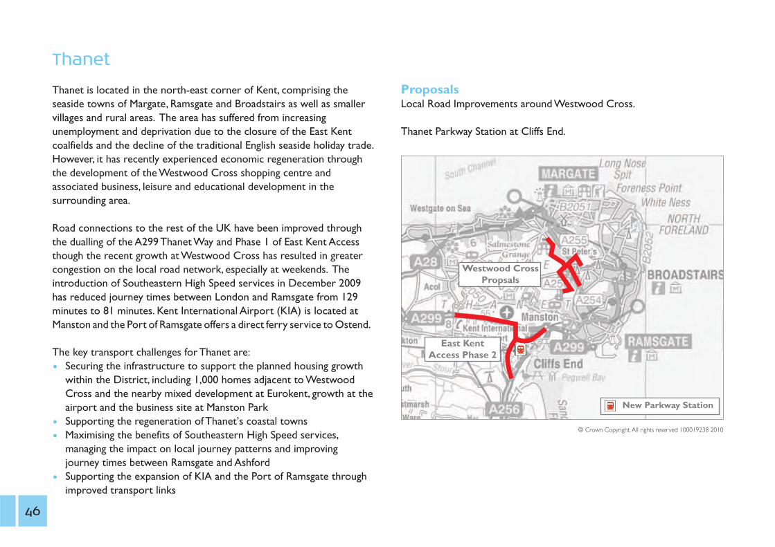
Thanet
Thanet is located in the north-east corner of Kent, comprising theseaside towns of Margate, Ramsgate and Broadstairs as well as smallervillages and rural areas. The area has suffered from increasingunemployment and deprivation due to the closure of the East Kentcoalfields and the decline of the traditional English seaside holiday trade.However, it has recently experienced economic regeneration throughthe development of the Westwood Cross shopping centre andassociated business, leisure and educational development in thesurrounding area.
Road connections to the rest of the UK have been improved throughthe dualling of the A299 Thanet Way and Phase 1 of East Kent Accessthough the recent growth at Westwood Cross has resulted in greatercongestion on the local road network, especially at weekends. Theintroduction of Southeastern High Speed services in December 2009has reduced journey times between London and Ramsgate from 129minutes to 81 minutes. Kent International Airport (KIA) is located atManston and the Port of Ramsgate offers a direct ferry service to Ostend.
The key transport challenges for Thanet are:1 Securing the infrastructure to support the planned housing growth
within the District, including 1,000 homes adjacent to WestwoodCross and the nearby mixed development at Eurokent, growth at theairport and the business site at Manston Park
1 Supporting the regeneration of Thanet’s coastal towns1 Maximising the benefits of Southeastern High Speed services,
managing the impact on local journey patterns and improving journey times between Ramsgate and Ashford
1 Supporting the expansion of KIA and the Port of Ramsgate through improved transport links
46
ProposalsLocal Road Improvements around Westwood Cross.
Thanet Parkway Station at Cliffs End.
New Parkway Station
Westwood CrossPropsals
East KentAccess Phase 2
© Crown Copyright.All rights reserved 100019238 2010

10. An Integrated Public Transport Network: supporting Kent’s workforce
Issue: growth in jobs and housing will create traffic gridlock
Action: creation of an integrated public transport network
Outcome: increased accessibility to goods and services, greaterchoice, particularly for those without access to a private car
Cost: £80m
Buses have a major role to play in offering more attractive traveloptions to those living in urban areas and rural communities(particularly those on or closer to main roads). Some 22% ofhouseholds in Kent do not have access to a car and many single vehicle households use the car for commuting, making the bus vital toallow them to reach the services and opportunities that some of ustake for granted.
Access to services is one of the key issues facing Kent’s rural areas andthe rural regeneration agenda. Although about 30% of Kent’spopulation lives in rural areas, most of these people live in communitieswhich can be easily served by attractive bus services, including fastinter-urban routes. Access to the countryside from urban areas forrecreation is also an important consideration.
Kent has always been a popular area for retirement and with most of usliving longer, a larger proportion of our residents will be over 60. They
will rely on buses to access healthcare, shops, entertainment and theirfriends and family. We also know that the current financial downturnhas made bus and rail travel more popular as people reconsider thecost of running and using their private car.
Significant areas of the County are not serviced by public transport. Byproviding short-term revenue support, expanded local bus routesoperating more frequently and providing better links can generatesignificantly more passengers in a short space of time without anongoing subsidy commitment.
The County Council has a successful record of working withcommercial bus operators through voluntary Quality Bus Partnership(QBP) agreements. There are now seven QBPs in Kent which have seenjoint investment by the County and District Councils and buscompanies in infrastructure, service frequency and vehicle quality.
Overall, the funding support provided by KCC and Government (in theform of concessionary reimbursement, Bus Service Operators Grant,Kickstart grants, bus stop infrastructure etc) accounts for over half theannual turnover of Kent's bus operators - amounting to some £60mper annum.
Whilst it is right and proper that operators receive these payments inorder to maintain a viable business, it is also right that they are held toaccount by local authorities and passengers for the way in which this
Gro
wth
without
grid
lock
A t
ransp
ort
deliv
ery
pla
n f
or
Kent
47

funding is spent. KCC will ensure that any new funding powers devolvedby the Coalition Government are put to good use in delivering betteroutcomes for bus passengers across the County.
The Kent Freedom Pass scheme provides free travel on almost all publicbus routes for an annual fee of currently £50 for young people living inKent. There are currently over 25,000 passes on issue and there isevidence of a 2.6% improvement in journey times outside schools witha high take up of passes. KCC will continue to build on its success andgive young people better access to life opportunities.
KCC is committed to improving the whole journey experience forpublic transport users. A key element of this is better integrationbetween bus and rail services. We will work closely with Network Rail,Southeastern and Southern through the proposed Kent Quality RailPartnership (KQRP) to deliver physical improvements to aidinterchange at rail stations and encourage people to travel to thestation by sustainable modes. This will include improvements to busaccess and infrastructure, cycle parking and walking and cycling routes.
We are currently working with Network Rail to deliver significantinterchange improvements at Sevenoaks station and with GraveshamBorough Council and Network Rail to deliver a new ‘TransportQuarter’ close to Gravesend station as part of the Town Centreregeneration project. We are also part-funding the procurement of newElectronic Ticket Machines (ETMs) with Smartcard readers for Kent’scommercial bus services. This offers the potential for integratedSmartcard ticketing for rail and bus services, similar to London’s OysterCard, thanks to the Government’s recent commitment to include arequirement to introduce Smartcard ticketing in all new rail franchises.
An Integrated Bus Network
Without much needed key road infrastructure, the County’s roadnetwork will struggle to cope with the proposed housing andemployment growth planned so we need to plan and provide moreefficient ways of getting people to where they want to go. The bus is akey part of the answer and lies at the heart of our proposed integratedtransport network. This network will be formed around integrating and connecting four different types of bus service, bus rapid transit,inter-urban coach services, local buses and rural interchange with otherforms of transport.An enhanced bus network will strengthen travelchoice and allow sustainable growth where new road infrastructure isdifficult to achieve.
Bus InterchangeThe crucial element of this integrated bus network is the ability tochange from one kind of service to another. This would be done atpassengers’ key destination points in town centres, at major transportinterchange points such as the local train station and at edge-of-townPark and Ride sites, which would also connect the rural bus servicesinto the existing commercial bus network. These interchange pointswould be a place where parents drop their children off to catch aschool bus to the urban centre, known as “kiss and ride” and would linkinto the local walking and cycling networks, providing additional facilitiessuch as cycle parking. This ease of interchange will be further enhancedby initiatives such as single ticketing across modes with simplermethods of payment.
48

Bus RapidTransit (BRT)
Bus Rapid Transit aims to provide a service thatoffers a “tram-like” mode of travel throughimprovements to infrastructure, vehicles andsimplicity of timetabling, as achieved by theFastrack service in Kent Thameside. The improvedfeatures include sections of bus-only routes tobypass queues, a strong image/brand, very frequentservice on a relatively direct route and off-busticketing. These improved features offer a genuineadvantage over the car for local journeys.
BRT is already planned for Ashford, calledSmartlink, which will link the major developmentareas in the town to the town centre, railwaystation, Park and Ride sites, business parks and theDesigner Outlet.
Fastrack and Smartlink have the potential totransform bus travel in Kent to support economicgrowth and regeneration. To date, Canterbury,Dover, Maidstone and Tunbridge Wells have beenidentified as potential future locations, as well asextending Fastrack itself in the Thames Gateway.The combination of the existing crossing and aLower Thames Crossing creates the opportunityfor an orbital bus rapid transit system linking thenorth Kent Thameside Fastrack network with theSouth Essex Rapid Transit (SERT) network.
loohcS
kraPtseWlatipsoH
loohcS
notgnilraDesruoCfloG
adsA
loohcS
snosirroMsdnaldooW
latipsoH
notgnilraDanerA
notgnilraD
tnioPdleifgniLkraPssenisuB
egelloC
loohcS
snosirroM
notgnilraDlairomeM
latipsoH
egelloC
loohcS
loohcS
P&R
P&R
P&R
P&R
etagworraHegalliV
taerGnodruB
nothguaH
notroMkraP
notroMsmlaProoMhtriF
poTknaB
nwoTertneC
lliHtreblA
ttonksremmuH
llewkcalB enrekSkraP
htuoSkraP
Mowden
notrekcoC
emosknarB
sroniMtnecserC
tseWkraP eladrevaF
hgiHegnarG
etagworraHlliH
dleifgnirpS
esiRrraC
llaHdeRtnomerreiP
dleifgniL
dleifnihW
Gro
wth
without
grid
lock
A t
ransp
ort
deliv
ery
pla
n f
or
Kent
Figure 10.1 Example of BRT Network
49

Inter-Urban Coach Service
Kent’s transport network has developed uponboth historic desire lines and natural physicalconstraints, meaning that many routes are radial,extending outwards from London. This isespecially true of the railway network, wheresome towns lack direct rail links. Good examplesare Sittingbourne to Maidstone and Faversham toAshford. Coach commuter services also operatefrom Kent into London.
In response, we will develop a network of inter-urban coach services offering direct, fast servicesalong major corridors. A good example is the highfrequency 101 service between Maidstone and theMedway towns. Whilst these services will havefew stops, they will serve Park & Ride sites on theurban periphery and other significant out of townlocations. In addition to urban centres, theseservices will also connect key transportinterchange points such as our passenger ports,international rail stations and airports. These alsoinclude cross-boundary services, for example,between Folkestone and Hastings.This networkcan be developed through start-up revenuefunding (Kickstart) in partnership with operators.
loohcS
latipsoH
loohcS
Retail Park
esruoCfloG
adsA
loohcS
snosirroM
latipsoH
anerA
Library
Library
Library
Library
Art Gallery
Country Park
Cathedral
Museum
University
Railway Station
kraPssenisuB
egelloC
loohcS
snosirroM
lairomeMlatipsoH
egelloC
loohcS
loohcS
Football Ground
P&R
P&R
P&R
P&R
etagworraHegalliV
taerGnodruB
nothguaH
Marton Pk
notroMsmlaProoMhtriF
poTknaB
nwoTertneC
lliHtreblA
ttonksremmuH
llewkcalB enrekSkraP
htuoSkraP
Mowden
emosknarB
sroniMtnecserC
tseWkraP eladrevaF
hgiHegnarG
etagworraHlliH
dleifgnirpS
esiRrraC
llaHdeRtnomerreiP
dleifgniL
dleifnihW
Figure 10.2 Example of Inter-Urban Coach Network
50
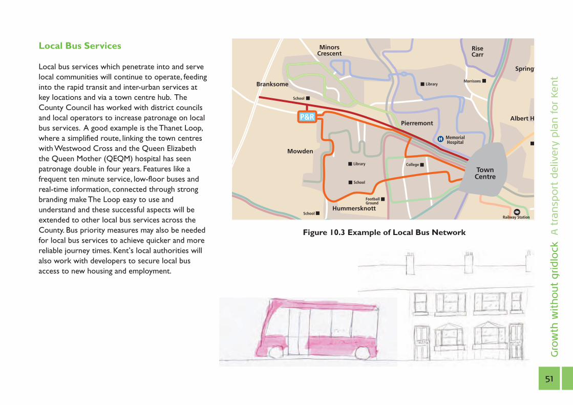
Local Bus Services
Local bus services which penetrate into and servelocal communities will continue to operate, feedinginto the rapid transit and inter-urban services atkey locations and via a town centre hub. TheCounty Council has worked with district councilsand local operators to increase patronage on localbus services. A good example is the Thanet Loop,where a simplified route, linking the town centreswith Westwood Cross and the Queen Elizabeththe Queen Mother (QEQM) hospital has seenpatronage double in four years. Features like afrequent ten minute service, low-floor buses andreal-time information, connected through strongbranding make The Loop easy to use andunderstand and these successful aspects will beextended to other local bus services across theCounty. Bus priority measures may also be neededfor local bus services to achieve quicker and morereliable journey times. Kent’s local authorities willalso work with developers to secure local busaccess to new housing and employment.
Gro
wth
without
grid
lock
A t
ransp
ort
deliv
ery
pla
n f
or
Kent
Figure 10.3 Example of Local Bus Network
loohcS
Railway Station
snosirroM
lairomeMlatipsoH
egelloC
loohcS
Library
Library
loohcS
Football Ground
P&R
nwoTertneC
HtreblA
ttonksremmuH
Mowden
emosknarB
sroniMtnecserC
fgnirpS
esiRrraC
tnomerreiP
51
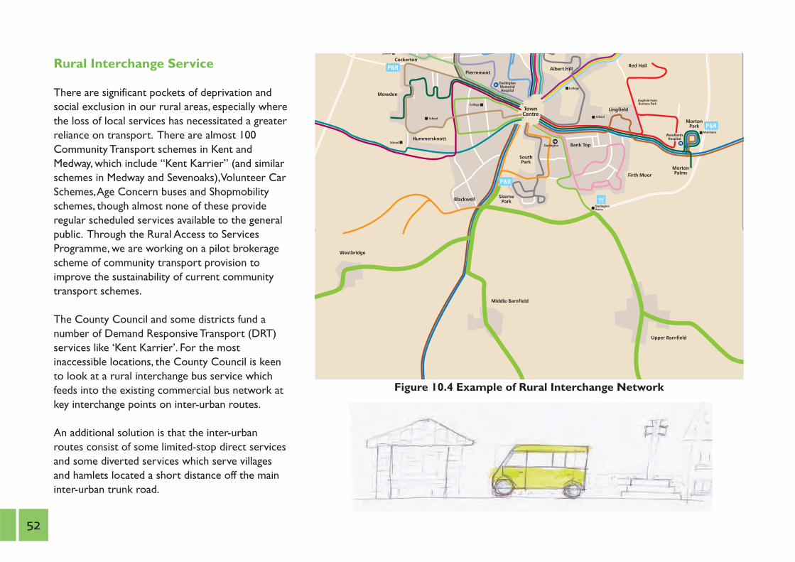
Rural Interchange Service
There are significant pockets of deprivation andsocial exclusion in our rural areas, especially wherethe loss of local services has necessitated a greaterreliance on transport. There are almost 100Community Transport schemes in Kent andMedway, which include “Kent Karrier” (and similarschemes in Medway and Sevenoaks),Volunteer CarSchemes,Age Concern buses and Shopmobilityschemes, though almost none of these provideregular scheduled services available to the generalpublic. Through the Rural Access to ServicesProgramme, we are working on a pilot brokeragescheme of community transport provision toimprove the sustainability of current communitytransport schemes.
The County Council and some districts fund anumber of Demand Responsive Transport (DRT)services like ‘Kent Karrier’. For the mostinaccessible locations, the County Council is keento look at a rural interchange bus service whichfeeds into the existing commercial bus network atkey interchange points on inter-urban routes.
An additional solution is that the inter-urbanroutes consist of some limited-stop direct servicesand some diverted services which serve villagesand hamlets located a short distance off the maininter-urban trunk road.
loohcS
snosirroMsdnaldooW
latipsoH
notgnilraDanerA
notgnilraD
tnioPdleifgniLkraPssenisuB
egelloC
loohcS
notgnilraDlairomeM
latipsoH
egelloC
loohcS
loohcS
P&R
P&R
P&R
notroMkraP
notroMsmlaProoMhtriF
poTknaB
nwoTertneC
lliHtreblA
ttonksremmuH
llewkcalB enrekSkraP
htuoSkraP
Mowden
Upper Barnfield
Middle Barnfield
Westbridge
notrekcoCllaHdeR
tnomerreiP
dleifgniL
Figure 10.4 Example of Rural Interchange Network
52

A Rail Action Plan for Kent
KCC’s bi-annual Rail Summits, bringing together the Department forTransport, Network Rail, Southeastern, Passenger Focus, local rail usergroups, MPs and local councillors, provide a powerful collective voice indiscussing the problems that the County’s commuters are suffering as aresult of recent timetable changes, as well as the benefits of the HighSpeed services and future aspirations. We are producing a Rail ActionPlan for Kent which will be used to inform future rail investment andservice plans, both in the short-term and for future rail franchises.
Major priorities for action include:
1 Reinstatement of the City service to Maidstone and West Malling.1 Extending the High Speed service from Dover via Deal and Sandwich
to Ramsgate.1 Feasibility of extending High Speed services from Ebbsfleet to
Maidstone West.1 Improving the journey times for the High Speed service from
Ashford via Canterbury and the proposed Thanet Parkway to Ramsgate.
1 Improvements to the North Kent line.1 Investigating the feasibility of introducing a through service between
Gatwick and Kent after 2015.1 Including Maidstone East as the principal Kent terminus for
Thameslink services from 2018.
We have already developed a strong working relationship with NetworkRail and are pursuing a number of these rail enhancements, which arepresented graphically in Figure 10.5. It is anticipated that the majority ofthese schemes will be taken forward for implementation in 2014. G
row
th w
ithout
grid
lock
A t
ransp
ort
deliv
ery
pla
n f
or
Kent
53

Ebbsfleet International
Ashford International
Gravesend
Strood
Sittingbourne
Sheerness
CanterburyWest
Thanet Parkway
Margate
Folkestone Central
Folkestone West
WestenhangerParkway
Maidstone Parkway Maidstone
East & West
Tunbridge Wells
To Hastings
Sevenoaks
Tonbridge
High Speed One
“Mainline”
Principal Stations
Proposed Parkway Stations
Dartford
ne
Deal
Ashford to Hastings line improvements
- up to 10 mins journey time saving (2014-2019)
Gatwick to Kent rail service via Ashford & Tonbridge (2015)
Thameslink services to City of London (2018)
Ashford to Ramsgate line improvements - up to 10 mins
journey time saving (2014)
Extension of High Speed Services to
Ramsgate via Deal &
Sandwich (2014)
Ramsgate
Dover PrioryIncremental line
improvements reducing journey time from Dover
to London to under 60 minutes (2014-2019)
Extension of High Speed Services to Maidstone West via Strood (2014)
Figure 10.5 Rail Enhancements
54

11. Local Development Frameworks: securing infrastructure This Strategy outlines a vision for the integrated transport networkneeded in Kent to support the planned growth in employment andhousing.As such, elements of this Strategy are aspirational and theprecise delivery mechanisms and timescales for its constituent projectshave yet to be determined. These will be progressed according to localand national political priorities and economic conditions, which will inturn dictate the pace of housing and commercial development over thenext 10-15 years. It is for this reason that the Strategy does not outlinea detailed Action Plan. Some initiatives proposed still require furtheranalysis and feasibility studies while others will require a change inattitudes and behaviours by all of us.
What is clear is that the actions will be delivered by many partnersworking together in two interlinked processes as shown in Figure 11.1.
1. Spatial Planning - deciding where development is to be locatedand its form. This is led by the Local Development Frameworks(LDFs) for each district.
2. Transport Planning - identifying which transport improvementsare needed for delivery through the Local Transport Plan (LTP)process and other funding mechanisms
These will be brought together at the local level through thedevelopment of Local Transport Strategies.
Gro
wth
without
grid
lock
A t
ransp
ort
deliv
ery
pla
n f
or
Kent
Spatial Planning Transport Planning
LocalTransport Strategy
LDF P R I O R ITY LTP 3
Figure 11.1 Planning and Delivery of the Transport Delivery Plan for Kent
55

Each of Kent’s 12 district and borough councils has a duty to prepare aLDF to replace their existing Local Plans. The LDF determines wheredevelopment can take place up to 2026 and contains a Core Strategywhich provides the spatial vision and strategic policies on issues likehousing, employment, biodiversity etc.
It is vital that transport infrastructure and the LDF are closelyintegrated since the location of development can have a substantialimpact on travel demand in a particular area. Therefore, the CountyCouncil works closely with districts to ensure alignment between theLDF and the LTP. Officers in Kent Highway Services also work closelywith their respective district councils to ensure that the transportimplications of development proposals are identified and mitigated at anearly stage in the planning process.
District councils are responsible for deciding the scale and location ofhousing, employment and other land uses in their LDFs. However, thedecisions taken by them may have long term implications for the costand delivery of KCC services. The County Council therefore workswith district councils to ensure that their LDFs are deliverable andaffordable.As part of this, KCC provides information and undertakesassessment of district council options for the scale and location ofdevelopment in their area as part of the essential evidence gatheringstage of the planning process. This role has become particularlyimportant in light of the Government’s proposed reduction in localauthority budgets and capital funding.
KCC therefore wishes to strengthen its working relationship with district councils in the preparation of LDFs to achieve thefollowing aims:
1 to ensure that KCC’s contributions to the LDF process are consistent, sound and fully explained.
1 to set out clearly the implications for KCC costs and services of the development options to be examined.
1 to take a consistent view of LDF proposals in the light of the Regeneration Framework and the KCC Housing, IntegratedTransport and Environment Strategies.
1 to work with district councils from the early stages of the LDFprocess in finding solutions that are be workable and affordable for KCC.
The Infrastructure Delivery Plan is a central part of the LDF. It sets outthe infrastructure required to deliver new development, along with itslocation and costs, and who will deliver it. It is therefore a vitalopportunity for KCC, as the authority responsible for the delivery ofhighway and community infrastructure, to influence the form of eachdistrict’s development proposals and its implications for KCC services.Some of the major transport infrastructure identified in Kent’s LDFs islisted below.
Currently (December 2010), four districts;Ashford, Dover,Tonbridge &Malling and Tunbridge Wells have adopted Core Strategies. Theremaining districts and Medway Council are at various stages in theproduction of their Core Strategies.
56

Transport Planning
Alongside Kent’s Local Development Frameworks, the other keyprocess which will deliver the objectives of this Strategy is theformulation, design and implementation of transport measures andinitiatives. In line with the Coalition Government’s devolutionaryplanning policies, these will increasingly be shaped by local communities.
LocalTransport Plan 3The Local Transport Plan (LTP) is a statutory document produced by alllocal transport authorities. It contains the authority’s vision, policies andobjectives for local transport and outlines an implementation plan oftransport schemes which will deliver these objectives for a certainallocation of funding from Central Government.
Kent County Council (KCC) has previously produced two LTPscovering the periods 2001-06 and 2006-11 respectively and a third LTPis required to be in place by 1st April 2011. Kent’s approach to LTP3 hasbeen based on the County Council’s new Regeneration Framework,Unlocking Kent’s Potential; and this Transport Delivery Plan, GrowthWithout Gridlock. Our LTP3 therefore proposes a new approach tothe delivery of transport infrastructure in Kent, which prioritisesinvestment in the County’s Growth Areas and Growth Points,maximises the benefits of high speed rail, anticipates the twin challengesof an ageing population and the impacts of climate change, and drawsupon new and innovative funding sources to secure the delivery ofhousing, economic growth and prosperity.
The strategy approach for LTP3 has been to develop five themeswhich are:
1 Growth Without Gridlock1 A Safer and Healthier County1 Supporting Independence1 Tackling a Changing Climate1 Enjoying Life in Kent
Using these themes, a range of options has been put forward for howto prioritise the funding we expect for LTP3. The preferredmethodology proposes to allocate a proportion of the budget to eachof the five themes and, within these themes, to focus the investment inthe areas where the challenges associated with each theme are mostacute.
Consultation on a draft LTP3 commenced in October 2010 and willclose on 31st December 2010. Since the level of funding that will beavailable for LTP3 is still not clear, a draft LTP3 Implementation Plan hasnot yet been prepared. However we expect there to be substantiallyless money available and in response, have identified possible alternativefunding streams to supplement LTP3 funding.
A Final LTP3 Strategy and Implementation Plan will be adopted by theend of March 2011.
Gro
wth
without
grid
lock
A t
ransp
ort
deliv
ery
pla
n f
or
Kent
57

Figure 11.2 The Kent, Greater Essex and East Sussex Local Enterprise Partnership
58

Local Enterprise Partnership
In October 2010, the Coalition Government gave the go-ahead forEngland’s largest Local Enterprise Partnership (LEP). The Kent, GreaterEssex and East Sussex LEP, which will be fully implemented from April2011, will bring together local authorities and businesses to create theright environment for economic growth. This will include identifyingand promoting schemes which improve connectivity, enhance skills,deliver new housing and increase tourism. The LEP, which will cover acombined population of some 3.9 million, and a business community of130,000 companies supporting over 1.3 million jobs, will pursue severalkey objectives, including:-
1 positioning Kent, Essex and East Sussex to compete more effectively with the English City Regions for inward investment;
1 redressing the East-West prosperity imbalance around London andexploiting the under-utilised economic capacity of Kent, Essex andEast Sussex;
1 championing and developing innovative solutions to the strategic infrastructure issues identified in this Strategy, including the need fora Lower Thames Crossing, greater road capacity and resilience in theChannel Corridor and improved rail access to East Kent; and
1 ensuring that businesses have the skilled workforces needed to compete, through the strengthening of relationships with universities,colleges, and local authorities.
LEPs will assume many of the functions of the Regional DevelopmentAgencies (RDAs), which were felt to be insufficiently accountable tolocal communities and are to be abolished by the CoalitionGovernment. With this in mind, the Kent, Greater Essex and EastSussex LEP will seek to balance democratic mandate with a strongvoice for business, with a Strategic Board including at least onerepresentative from the voluntary or social enterprise sector. It will fullyembrace the localism agenda, devolving decision-making and controlwherever possible and encouraging local innovation to meet local needs.
Gro
wth
without
grid
lock
A t
ransp
ort
deliv
ery
pla
n f
or
Kent
59
12. Priorities for Growth without gridlockThe big, key, transport drivers for change
Plans for a LowerThames Crossing to unlock growth in the Thames Gateway and to relieve the congestion which costs the UK economy some £40m annually.
The “bifurcation” of traffic from Dover Docks to use both the M20/A20 and M2/A2 corridors, with freight through the Port expected to double over the next 20 years.
A long-term solution to Operation Stack which costs the haulage industry some £1m a day.
Maximising the benefits of High Speed Rail, especially to East Kent.
Developing a Parkway station forThanet, serving Manston Airport, unlocking new economic development opportunities in East Kent at minimal cost.
Integrating public transport networks to stimulate the rural economy.
Further improving traffic management in our towns to reduce congestion and improve air quality.
Linking new infrastructure more closely to local planning through the District Local Development Framework planning process.
Pressing for greater local control of highways spending to provide quicker and cheaper ways of delivering strategic road infrastructure such at the urgently needed dualling of the A21.
District priorities - key challenges and proposals.
60


Integrated Strategy and PlanningInvicta House, Maidstone, Kent ME14 1XX
www.kent.gov.uk
Tel: 01622 221050
This document is available in alternative formats and can be explained in a range of languages. Please call 01622 221050 for details.


