A RIVER THAT IS A PARK A PARK THAT IS A RIVER RiverEdge ...
25
A RIVER THAT IS A PARK A PARK THAT IS A RIVER RiverEdge Park Master Plan City of Aurora Aurora Park Collaborative September 2007 Music flows from the shell, lingering in our memory. We cross the cable bridge, lamp light reflecting gold upon the river. We are gathering to share the sounds of many cultures, of many ages. There are crowds, crowds who arrive in great haste, on bus, train, by car, bicycle, by boat, and on foot. Neighbors descend from the hills, following the trail of the Fox, to the celebration at the river. Our reflection shimmers as we look from above, carving a luminous band of light along the water. Within this circle connecting the shores, is what we have been seeking. The river. From within this bridge’s suspended embrace we view the panorama of nature, the path of our ancestors, the river’s ebb and flow, a new perspective of ourselves as part of this natural environment. At this moment, we are so small, yet can touch the sky by looking down, and enjoy inclusion within the glories of this place. With the design and construction of RiverEdge Park, we believe Aurora’s greater community will come to experience the unique attributes of this land, and appreciate why our forefathers settled here, strengthening our connections to our past, and to our future. City of Aurora 44 East Downer Place Aurora, IL 60507 630.844.3614 phone 630.844.3638 fax www.aurora-il.org
Transcript of A RIVER THAT IS A PARK A PARK THAT IS A RIVER RiverEdge ...

A RIVER THAT IS A PARK A PARK THAT IS A RIVER
RiverEdge Park Master Plan
City of AuroraAurora Park Collaborative
September 2007
Music flows from the shell, lingering in our memory. We cross the cable bridge, lamp light reflecting gold upon the river. We are gathering to share the sounds of many cultures, of many ages.
There are crowds, crowds who arrive in great haste, on bus, train, by car, bicycle, by boat, and on foot. Neighbors descend from the hills, following the trail of the Fox, to the celebration at the river.
Our reflection shimmers as we look from above, carving a luminous band of light along the water. Within this circle connecting the shores, is what we have been seeking. The river. From within this bridge’s suspended embrace we view the panorama of nature, the path of our ancestors, the river’s ebb and flow, a new perspective of ourselves as part of this natural environment. At this moment, we are so small, yet can touch the sky by looking down, and enjoy inclusion within the glories of this place.
With the design and construction of RiverEdge Park, we believe Aurora’s greater community will come to experience the unique attributes of this land, and appreciate why our forefathers settled here, strengthening our connections to our past, and to our future.
City of Aurora
44 East Downer PlaceAurora, IL 60507
630.844.3614 phone630.844.3638 faxwww.aurora-il.org
1TAbLE OF CONTENTS
TAbLE OF CONTENTS
FOREWORD....................................................................................... 2
INTRODUCTION .............................................................................. 4
EXISTING CONTEXT Context Diagrams.................................................................... 7 Future Development................................................................ 10 RiverEdge Park Economic Impact............................................ 11 Existing and Future Parking Capacity...................................... 12
RIVEREDGE PARK MASTER PLAN Plan Elements.......................................................................... 15 Activities and Design Elements............................................... 16
(A) Wilder Park / West RiverEdge........................................... 18 (b) River Crossing/ blues Island Preserve................................. 22 (C) Garden Market and Event Space........................................ 26 (D) Outdoor Performance Venue and Lawn............................ 32 (E) Indian Creek Wetland / Environmental Center................... 36 Conculsion............................................................................... 40
ACKNOWLEDGEMENTS .................................................................. 44
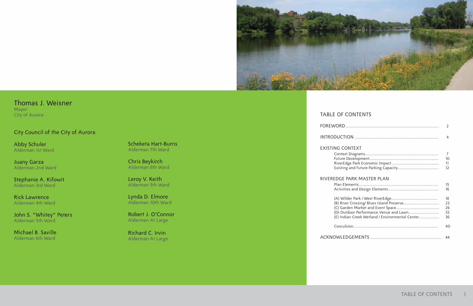
Thomas J. WeisnerMayor City of Aurora
City Council of the City of Aurora
Abby SchulerAlderman 1st Ward
Juany GarzaAlderman 2nd Ward
Stephanie A. KifowitAlderman 3rd Ward
Rick LawrenceAlderman 4th Ward
John S. “Whitey” PetersAlderman 5th Ward
Michael b. SavilleAlderman 6th Ward
Scheketa Hart-burnsAlderman 7th Ward
Chris beykirchAlderman 8th Ward
Leroy V. KeithAlderman 9th Ward
Lynda D. ElmoreAlderman 10th Ward
Robert J. O’ConnorAlderman At Large
Richard C. IrvinAlderman At Large
2 3FOREWORD
FOREWORD
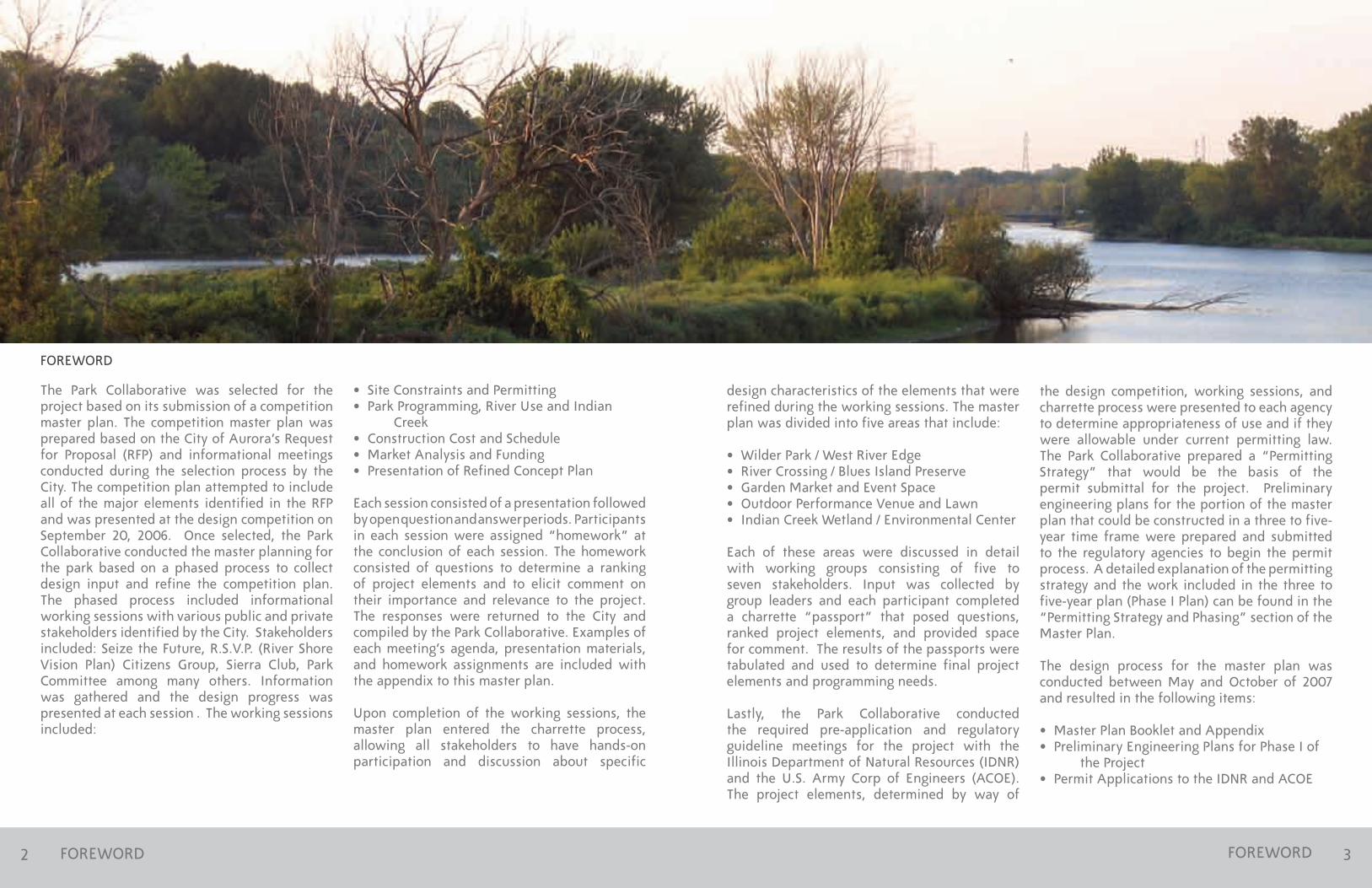
The Park Collaborative was selected for the project based on its submission of a competition master plan. The competition master plan was prepared based on the City of Aurora’s Request for Proposal (RFP) and informational meetings conducted during the selection process by the City. The competition plan attempted to include all of the major elements identified in the RFP and was presented at the design competition on September 20, 2006. Once selected, the Park Collaborative conducted the master planning for the park based on a phased process to collect design input and refine the competition plan. The phased process included informational working sessions with various public and private stakeholders identified by the City. Stakeholders included: Seize the Future, R.S.V.P. (River Shore Vision Plan) Citizens Group, Sierra Club, Park Committee among many others. Information was gathered and the design progress was presented at each session . The working sessions included:
• Site Constraints and Permitting • Park Programming, River Use and Indian Creek • Construction Cost and Schedule • Market Analysis and Funding • Presentation of Refined Concept Plan
Each session consisted of a presentation followed by open question and answer periods. Participants in each session were assigned “homework” at the conclusion of each session. The homework consisted of questions to determine a ranking of project elements and to elicit comment on their importance and relevance to the project. The responses were returned to the City and compiled by the Park Collaborative. Examples of each meeting’s agenda, presentation materials, and homework assignments are included with the appendix to this master plan.
Upon completion of the working sessions, the master plan entered the charrette process, allowing all stakeholders to have hands-on participation and discussion about specific
design characteristics of the elements that were refined during the working sessions. The master plan was divided into five areas that include:
• Wilder Park / West River Edge• River Crossing / Blues Island Preserve• Garden Market and Event Space • Outdoor Performance Venue and Lawn • Indian Creek Wetland / Environmental Center
Each of these areas were discussed in detail with working groups consisting of five to seven stakeholders. Input was collected by group leaders and each participant completed a charrette “passport” that posed questions, ranked project elements, and provided space for comment. The results of the passports were tabulated and used to determine final project elements and programming needs.
Lastly, the Park Collaborative conducted the required pre-application and regulatory guideline meetings for the project with the Illinois Department of Natural Resources (IDNR) and the U.S. Army Corp of Engineers (ACOE). The project elements, determined by way of
the design competition, working sessions, and charrette process were presented to each agency to determine appropriateness of use and if they were allowable under current permitting law. The Park Collaborative prepared a “Permitting Strategy” that would be the basis of the permit submittal for the project. Preliminary engineering plans for the portion of the master plan that could be constructed in a three to five-year time frame were prepared and submitted to the regulatory agencies to begin the permit process. A detailed explanation of the permitting strategy and the work included in the three to five-year plan (Phase I Plan) can be found in the “Permitting Strategy and Phasing” section of the Master Plan. The design process for the master plan was conducted between May and October of 2007 and resulted in the following items: • Master Plan Booklet and Appendix • Preliminary Engineering Plans for Phase I of the Project • Permit Applications to the IDNR and ACOE
FOREWORD
MCCULLOUGH PARKNEIGHbORHOOD
LAKE STREET NEIGHbORHOOD
WILDER PARK NEIGHbORHOOD
ISLAND VIEW NEIGHbORHOOD
NEAR EAST SIDE NEIGHbORHOOD
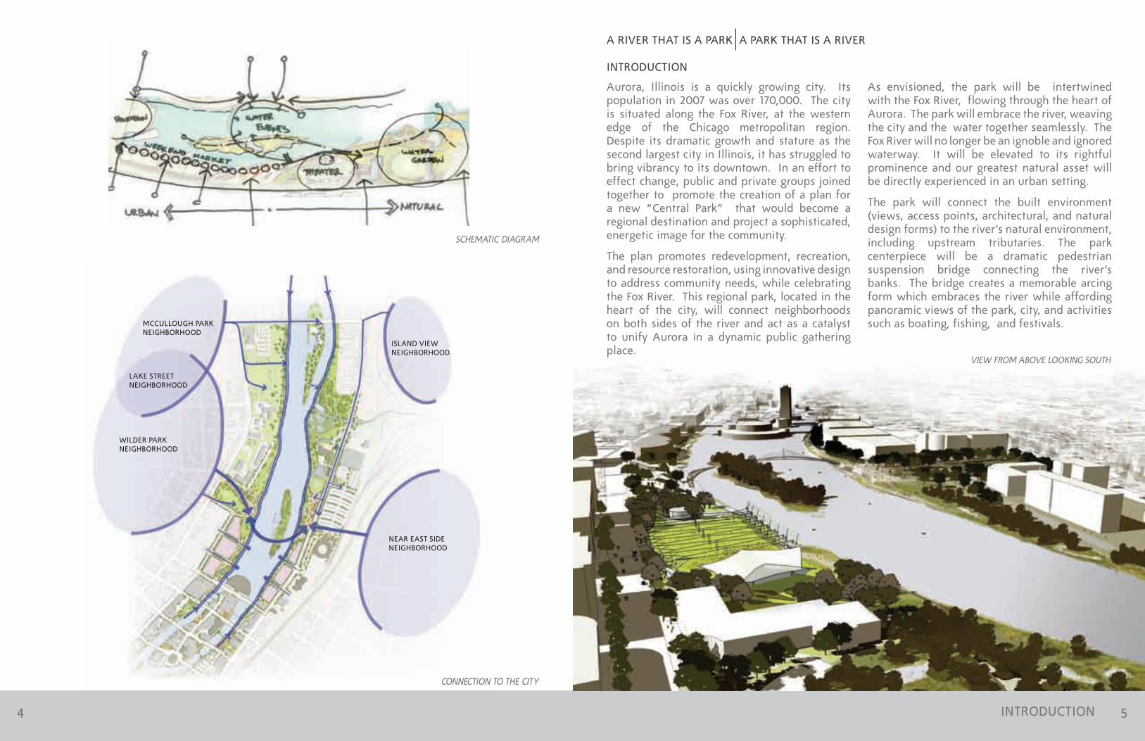
Aurora, Illinois is a quickly growing city. Its population in 2007 was over 170,000. The city is situated along the Fox River, at the western edge of the Chicago metropolitan region. Despite its dramatic growth and stature as the second largest city in Illinois, it has struggled to bring vibrancy to its downtown. In an effort to effect change, public and private groups joined together to promote the creation of a plan for a new “Central Park” that would become a regional destination and project a sophisticated, energetic image for the community.
The plan promotes redevelopment, recreation, and resource restoration, using innovative design to address community needs, while celebrating the Fox River. This regional park, located in the heart of the city, will connect neighborhoods on both sides of the river and act as a catalyst to unify Aurora in a dynamic public gathering place.
INTRODUCTION
VIEW FROM ABOVE LOOKING SOUTH
A RIVER THAT IS A PARK A PARK THAT IS A RIVER
INTRODUCTION
As envisioned, the park will be intertwined with the Fox River, flowing through the heart of Aurora. The park will embrace the river, weaving the city and the water together seamlessly. The Fox River will no longer be an ignoble and ignored waterway. It will be elevated to its rightful prominence and our greatest natural asset will be directly experienced in an urban setting.
The park will connect the built environment (views, access points, architectural, and natural design forms) to the river’s natural environment, including upstream tributaries. The park centerpiece will be a dramatic pedestrian suspension bridge connecting the river’s banks. The bridge creates a memorable arcing form which embraces the river while affording panoramic views of the park, city, and activities such as boating, fishing, and festivals.
CONNECTION TO THE CITY
SCHEMATIC DIAGRAM
4 5

6 7SITE PLAN
INDIAN CREEK
RIVER WALK
AURORA TRANSPORTATIONCENTER (ATC)
STOLP ISLAND
LAKE
ST
(IL
ROU
TE 3
1)
WEST PARK AVE
LINC
OLN
AVE
ILLINOIS AVE
PIERCE ST
bRO
AD
WA
Y (
IL R
OU
TE 2
5)
SPRING ST
NEW YORK ST
RIVE
R ST
EXISTING CONTEXT
The proposed park site is a historically significant location within the 170-mile long Fox River watershed. The famed Potowatomi Chief Waubonsie settled nearby, coming to the river to hunt the rich forested banks and marshy pools at the outflow of nearby creeks. This site is also where the river islands of the Fox provided the physiographic location and water power to run the McCarty brothers’ milling and manufacturing operations on the banks of the Fox River. This historic settlement eventually led to the incorporation of Aurora in 1857.
The park site is bisected by the Fox River and surrounded on three sides by major north-south and east-west traffic corridors connecting through the downtown area to all sections of the city and
GALENA bLVDDOWNER PL
bENTON ST
STOLP
AVESITE bOUNDARY
VETERANSISLAND
bLUES ISLAND
FOX RIVER
CASINO
Park Site boundary
RiverWalk
EXISTING SITE
SCALE 1” = 600’
MCCULLOUGH PARK
N
nearby communities. Residential neighborhoods exist blocks from the river’s edge to the east and to the west, but are poorly connected to the river and the downtown business district. The land, much of which lies in a floodplain, slopes down to the river on both sides with varying grades and steepness. Historical land uses include parking, commercial and industrial sites, and open space. Environmental remediation will be part of the park development.
As a place owing its very existence to the Fox River, this land represents a major opportunity for Aurora. The site is conveniently located adjacent to the City’s historic downtown business district, the Aurora Transportation Center, the Hollywood Casino, and the Paramount Arts Center.
EXISTING CONTEXT
PLUM ST
VINE ST
CEDAR ST
SPRUCE ST
CLAIM ST
LIbERTY ST

8 9VISUAL CORRIDORS AND VISTAS
VIEW WEST TO BLUES ISLAND
VISUAL CORRIDORS AND VISTAS
VIEW NORTH FROM PEDESTRIAN BRIDGE SITE
VIEW EAST FROM WILDER PARK VIEW SOUTH FROM INDIAN CREEK BRIDGE
VIEW WEST FROM THE PERFORMANCE VENUE SITEVIEW EAST TO BLUES ISLAND FROM BRIDGE LANDING SITE
10 11
Significant New Development
New Residential Development
Redevelop Existing Structures
New Green Space
New Civic Facility
FUTURE DEVELOPMENT *
Preserve Existing Residential
Existing Green Space
* Source Note: Land use projections derived from “Seizing the Future: A Master Plan for Downtown Aurora, Illinois, Autumn 2005”
LAKE
ST
(IL
ROU
TE 3
1)
WEST PARK AVE
LINC
OLN
AVE
ILLINOIS AVE
PIERCE ST
bRO
AD
WA
Y (I
L RO
UTE
25)
SPRING ST
NEW YORK ST
RIVER
ST
FUTURE DEVELOPMENT
GALENA bLVDDOWNER PLbENTON PL
STOLP
AVE
ISLAND VIEW NEIGHbORHOOD
VETERANSISLAND
bLUES ISLAND
MCCULLOUGH PARK
FOX RIVER
CASINO
WAUbONSEENEIGHbORHOOD
WILDER PARK NEIGHbORHOOD
LAKE STREET NEIGHbORHOOD
MCCULLOUGH PARKNEIGHbORHOOD
STOLP ISLANDNEIGHbORHOOD
MERCADONEIGHbORHOOD
ROUNDHOUSE NEIGHbORHOOD
SCALE 1” = 600’N
RIVER PARK ECONOMIC IMPACT
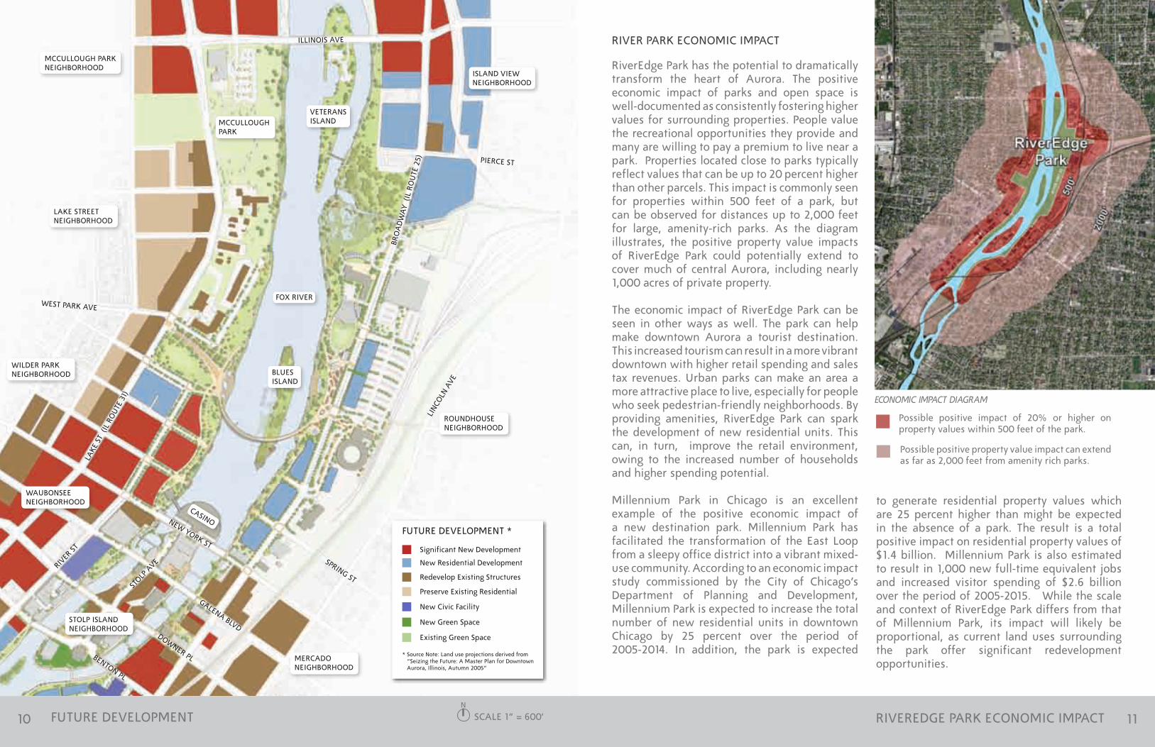
RiverEdge Park has the potential to dramatically transform the heart of Aurora. The positive economic impact of parks and open space is well-documented as consistently fostering higher values for surrounding properties. People value the recreational opportunities they provide and many are willing to pay a premium to live near a park. Properties located close to parks typically reflect values that can be up to 20 percent higher than other parcels. This impact is commonly seen for properties within 500 feet of a park, but can be observed for distances up to 2,000 feet for large, amenity-rich parks. As the diagram illustrates, the positive property value impacts of RiverEdge Park could potentially extend to cover much of central Aurora, including nearly 1,000 acres of private property.
The economic impact of RiverEdge Park can be seen in other ways as well. The park can help make downtown Aurora a tourist destination. This increased tourism can result in a more vibrant downtown with higher retail spending and sales tax revenues. Urban parks can make an area a more attractive place to live, especially for people who seek pedestrian-friendly neighborhoods. by providing amenities, RiverEdge Park can spark the development of new residential units. This can, in turn, improve the retail environment, owing to the increased number of households and higher spending potential.
Millennium Park in Chicago is an excellent example of the positive economic impact of a new destination park. Millennium Park has facilitated the transformation of the East Loop from a sleepy office district into a vibrant mixed-use community. According to an economic impact study commissioned by the City of Chicago’s Department of Planning and Development, Millennium Park is expected to increase the total number of new residential units in downtown Chicago by 25 percent over the period of 2005-2014. In addition, the park is expected
RIVEREDGE PARK ECONOMIC IMPACT
ECONOMIC IMPACT DIAGRAM
Possible positive impact of 20% or higher on property values within 500 feet of the park.
Possible positive property value impact can extend as far as 2,000 feet from amenity rich parks.
to generate residential property values which are 25 percent higher than might be expected in the absence of a park. The result is a total positive impact on residential property values of $1.4 billion. Millennium Park is also estimated to result in 1,000 new full-time equivalent jobs and increased visitor spending of $2.6 billion over the period of 2005-2015. While the scale and context of RiverEdge Park differs from that of Millennium Park, its impact will likely be proportional, as current land uses surrounding the park offer significant redevelopment opportunities.

12 13
144
121
184
775
155
291
154
60
213
65
204
376
100
188
51
65
167
-108
90
-42
53
LAKE
ST
(IL
ROU
TE 3
1)
WEST PARK AVE
LINC
OLN
AVE
ILLINOIS AVE
PIERCE ST
bRO
AD
WA
Y (I
L RO
UTE
25)
SPRING ST
NEW YORK ST
GALENA bLVD
RIVER
ST
EXISTING AND FUTURE PARKING CAPACITY
Parking to be Removed
Parking to be Redeveloped
Existing Parking to Remain
PARKING
DOWNER PLbENTON PL
STOLP
AVE
ISLAND VIEW NEIGHbORHOOD
VETERANSISLAND
bLUES ISLAND
ROUNDHOUSE NEIGHbORHOOD
MCCULLOUGH PARK
FOX RIVER
CASINO
WAUbONSEENEIGHbORHOOD
WILDER PARK NEIGHbORHOOD
LAKE STREET NEIGHbORHOOD
MCCULLOUGH PARKNEIGHbORHOOD
STOLP ISLANDNEIGHbORHOOD
MERCADONEIGHbORHOOD
SCALE 1” = 600’
EXISTING AND FUTURE PARKING CAPACITY
Parking needs for the project were determined based on the demand of the Outdoor Performance Venue at full capacity; this being the worst case scenario for routine programming. The Park Collaborative also took inventory of the current total public/private parking capacity within a reasonable walking distance of the project site. The Park Collaborative determined the number of parking spaces that will likely be impacted by future development is identified and discussed in detail in the Seize the Future Master Plan for Downtown. It is assumed that the City will require the replacement of any parking loss due to redevelopment, in addition to addressing the parking needs generated by new development. The results of the parking tabulation are depicted in the diagram to the left.
N
EXISTING AND FUTURE PARKING CAPACITY
AURORA TRANSPORTATIONCENTER (ATC)
Total parking required for Phase I of the RiverEdge Park is estimated at 1,158 spaces. Assuming that the 775 spaces in the ATC lot is available for park activities, the anticipated total additional parking required for Phase I equals 383. Additional parking studies will need to be undertaken to determine estimated requirements as future phases of the park are planned.

14 15
PLAN ELEMENTS
WILDER PARK / WEST RIVER EDGE
This site is currently occupied by a City of Aurora police station, which is being relocated in the near future. Demolition of the existing building will open up new parkland, allowing for dramatic vistas down to the river from the west side neighborhoods and providing a connection to the park and river. This area will be designed for picnicking, gatherings, a weekend market and special events staging.
RIVER CROSSING / bLUES ISLAND PRESERVE
The central focus of the park is a new river crossing. This will take the form of an iconic pedestrian bridge. The bridge’s curved main span is supported by a single mast cable suspension system. The arc shape of the bridge is duplicated on both river shorelines in the form of a curving boardwalk. The bridge embraces the river.
blues Island will be restored; exotic plant species will be removed and replaced with native plants. The island will then function as a mid-river nature sanctuary.
GARDEN MARKET AND EVENT SPACE
The garden market and event space will form an eastern gateway to the park. It will be composed of raised planters forming a weave of pathways and spaces that gently slope down to the river. This space will also house a weekend market. both urban and natural in form, the garden and its market act as a transition from the city to the naturalism of the park.
OUTDOOR PERFORMANCE VENUE AND LAWN
The outdoor performance venue is the major functional element of the park. It acts as a platform from which visitors can experience cultural events, the natural setting of the river and the vibrancy of downtown Aurora. It is shaped by a colonnade of pylons which define its seating bowl and support a sophisticated sound system. The lawn will serve as a flexible venue for large concerts and picnics.
INDIAN CREEK WETLAND / ENVIRONMENTAL CENTER
At the north end of the site, Indian Creek flows into the Fox River. A new wetland will be created at the mouth of the stream, restoring it to its more natural form. This wetland will serve as compensatory storage for rainwater, allowing other park elements to be constructed in flood zones and providing an urban wildlife area and environmental education center.
RIVEREDGE PARK MASTER PLAN
A
b
A
b
C
D
E
C
D
E
SCALE 1” = 500’N
PLAN ELEMENTS

16 17ACTIVITIES AND DESIGN ELEMENTS
?
FM
t
INFORMATION
RESTROOMS
CONCESSIONS
TICKETING
PARKING
OUTDOOR MARKETS
PICNICKING
vITINERANT PERFORMERS
CHILDREN’S PLAY AREA
PEDESTRIAN CROSSING
G
b
bICYCLE PATHS
WALKING/JOGGING PATHS
NATURAL HAbITAT
NATURE VIEWING
PUbLIC TRANSPORTATION
J
5
PHOTOGRAPHY
bIRD WATCHING
CANOEING AND KAYAKING
FISHING
ACTIVITIES AND DESIGN ELEMENTS
TFIREWORKS / LIGHT SHOWS
STAIRS
RAMPED WALKWAYS
bOARDWALK
FOX RIVER TRAIL
GSOFT RIVER EDGE
UNDERPASS
WATER FEATURE / FOUNTAIN
ICE SKATING
SLEDDING / WINTER ACTIVITIES
Information kiosks are located throughout the park and natural areas. Information counters are located in the Event Pavilion and the Indian Creek Environmental Center.
HADA ACCESSIbLE
All paths and spaces within the park are ADA accessible to provide universal access.
The Fox River Trail extends through the park on the east and west banks of the river and across the non-motorized bridge. bicycle paths link surrounding neighborhoods, providing connectivity for area residents.
Paths for walking, jogging and other recreation wind throughout the park on multiple levels, showcasing views of downtown and the river.
Enhanced crosswalks paved with brick or stamped asphalt define safe pedestrian crossings leading into the park. Traffic signals and signage combined with traffic management during special events provide safe and convenient pedestrian access.
New parking accommodates visitors for concerts, markets and other special events. A dedicated lot serves the Indian Creek Environmental Center, located at the north end of the park.
Convenient rail and bus service is available on the east side of broadway at the Aurora Transportation Center (ATC).
A dramatic, terraced walkway leads visitors to the river’s edge from Wilder Park. The stairs become an impromptu grandstand for crowds viewing performances on the boardwalk below, events on the river and nighttime light shows and fireworks.
Ramped walkways throughout the park allow for access to all of the park amenities and activities.
The boardwalk winds up and down and in and out along the edge of the river, much like the ebb and flow of the water, providing ideal places for fishing or sitting close to the water. broad stone or concrete steps descend into the water from which canoes and kayaks can be launched.
The Fox River Trail extends into the park and connects to the downtown FoxWalk/Riverwalk at New York Street. Where the city meets the park, the upper level riverwalk provides opportunities for outdoor cafes, seating areas, event spaces and public art.
The Fox River Trail passes below the non-motorized bridge, close to the river’s edge creating dynamic spaces. The bridge and its approach paths are built above the floodplain to allow access in all seasons.
The riverbank is maintained as a natural soft edge of sand, soil and native plants throughout the park. boardwalks are built above the soft river edge. The soft edge is interrupted by hard edges at three small stepped landings that extend into the water, at the terminus of Spring, Spruce and Cedar Streets.
Dramatic water displays are found throughout the park.
Permanent public restroom facilities are provided at the Performance Venue, the Visitors Center and the Indian Creek Environmental Center. Temporary restrooms are provided at strategic locations to accommodate visitors attending special events.
Permanent concession operations are housed in the Performance Venue, the Visitors Center, and the Indian Creek Environmental Center. Temporary concessions are provided at strategic locations in the Garden Market and the Wilder Park Market to accommodate visitors attending special events.
Ticket windows and related operations are located in the Community Center. Additional ticketing may be housed in tents at the gates and in the seating pavilion for larger events in the Performance Venue.
Outdoor public markets, farmers’ markets, art fairs, etc. are accommodated in the expansive Wilder Park Market on the west side of the river, with additional vendor and market space at the Garden Market on the east bank.
The Children’s Play Area acts as a welcoming gateway to the southern entry to the park. It features engaging spaces and structures for exercise and fun throughout the year. Large-scale and intriguing fountains, sculpture, and interactive musical instruments allow kids to exercise their bodies and their minds in a striking outdoor setting.
Multiple settings exist throughout the park for both planned and impromptu smaller-scale performances.
The bridge and both riverbanks serve as front row seating for crowds drawn to the riverfront for light shows and fireworks displays.
Ice skating facilities are found throughout the park.
Opportunities for water recreation occur all along the river’s edge.
The lawns at Wilder Park and the Performance Venue provide comfortable spots for picnics overlooking the river.
The bridge and boardwalks provide ideal locations for fishing.
blues Island and the Indian Creek Wetland Area are ideal spots for bird watching.
The natural habitat of the river is restored on blues Island and at the mouth of Indian Creek.
blues Island and the Indian Creek Wetland Area are ideal spots for viewing nature.
Sledding and winter festivals can be experienced at many sites throughout the park.
Views from every angle of the park are ideal photographic backdrops and subjects.

18 19
J
WILDER PARK
This portion of the park serves as the main link between the west-side residential neighborhoods and the Fox River. Once the home of the central Aurora police station, it is now an open natural area, jutting up from the river into the city fabric. The land slopes dramatically down to the water and features a broad lawn surrounded by groves of mature trees. Views of the river and the east shore are engaging. Water features and the Wilder Park Market distinguish this side of the river.
Water access and boat launches dot the Fox River Trail as it winds through Wilder Park. Piers are located on axis with the city street grid. The riverbanks have been restored, using natural materials and native plants. Wilder Park connects seamlessly with the bridge over the Fox River and McCullough Park to the north. Open expanses of land function as a meeting place with sweeping views of the river and water-based activities.
?
?
WILDER PARK / WEST RIVER EDGE
LAKE
STR
EET
(IL
ROU
TE 3
1)
RIVE
R ST
REET
SCALE 1” = 100’
FOX RIVER
N
WILDER PARK / WEST RIVER EDGE
b
G
vVINE STREET
WEST PARK AVENUE
RIVE
R ST
REET
A A
Refer to pages 18 and 19 for activities and design elements

20 21
SECTION LOOKING SOUTH
WILDER PARK / WEST RIVER EDGE
WILDER PARK bRIDGE LANDING
WATER FEATURE
SCALE 1” = 30’
bLUES ISLAND
A WILDER PARK / WEST RIVER EDGE A
TYPICAL WILDER PARK MARKET SCENEBOARDWALK VIEW LOOKING TOWARD THE BRIDGE AND WILDER PARK
The boardwalk provides an opportunity to interact with the river that flows through the heart of Aurora. The entire area includes extensive landscaping, plus welcoming lighting and seating areas. Restoration of the water edge enhances the river’s water quality. best management practices
have been implemented to protect the river and its banks. Easy access to the water is provided by docks and the boardwalk system, allowing visitors direct contact with the water for boating, fishing or simply sitting and enjoying a moment of respite.
Walking north, passing under the bridge, people experience the sensation of moving into an outdoor “room” created by the arc of the bridge. The southwestern gateway is marked by a water feature that draws attention to the visual center of the park and forms a dramatic
civic space. A grand terrace leads to the great lawn, with a view across the river to blues Island and the Performance Venue.

22 23
bRO
AD
WAY
(IL
RO
UTE
25)
G
RIVER CROSSING / bLUES ISLAND PRESERVE
bLUES ISLAND
THE bRIDGE
This important pedestrian bridge unites the city by connecting the east and west sides of the Fox River. Convenient bicycle/pedestrian access to the Aurora Transportation Center is made possible. The bridge provides a natural vantage point from which people can watch festivals and river activities, or simply stroll along to enjoy the view. The bridge is a dramatic focal point for the park and the city. Its curving form embraces the river, drawing attention to the water. Its single-masted cable suspension system is a unique landmark, juxtaposed against the backdrop of the Aurora skyline.
The bridge becomes a symbol of Aurora’s historic heritage as “The City of Lights” when dramatic evening displays illuminate both the bridge and the water in a union of nature and technology.
At the center of this iconic bridge is a natural sanctuary called blues Island. After extensive restoration efforts, the island has become a unique urban wildlife habitat, viewable but inaccessible to people.
FOX RIVER
SCALE 1” = 100’N
RIVER CROSSING / bLUES ISLAND PRESERVE
J?
G
v
T
PEDESTRIAN bRIDGE
G
?
?
b b
Refer to pages 18 and 19 for activities and design elements

24 25
BRIDGE AND RIVER LOOKING NORTHEAST
bLUES ISLAND PRESERVE
SECTION LOOKING SOUTH
WILDER PARKbRIDGE LANDING
WILDER PARK BRIDGE LANDING
GARDEN MARKETbRIDGE LANDING
SCALE 1” = 40’ RIVER CROSSING / bLUES ISLAND PRESERVE RIVER CROSSING / bLUES ISLAND PRESERVEb b

26 27
b
FM t
G
GARDEN MARKET AND EVENT SPACE
bRO
AD
WAY
(IL
RO
UTE
25)
bLUES ISLAND
THE GARDEN MARKET
The Garden Market is the primary “hardscaped” area of the park where all public paths converge. It serves as a significant public gathering spot and is multi-functional, incorporating native botanic displays into raised planters which are designed to accommodate seating and vendor stations. Planters are located strategically so as to invite people to walk between them and enjoy a system of meandering paths. In the summer, outdoor markets are staged along the pathways. Urban activities are infused into a natural setting so that the city and park interlock. The Garden Market can flow over the bridge and along the river edge as it expands over time.
Two LEED (Leadership in Energy and Environmental Design) buildings flank the Garden Market on the north and act as an entryway to the Performance Venue. The Visitors Center offers information, public restrooms, meeting spaces and concessions. The Community Center houses the Mayor’s Office of Special Events, ticket sales, public meeting spaces and places for year round market activities.
A boardwalk runs parallel to the Garden Market, which terraces down to the river’s edge. A water fountain mirrors a similar feature on the west bank of the river. both dancing displays can be synchronized with one another and with other water features throughout the park and on the river.
FOX RIVER
SCALE 1” = 100’N
GARDEN MARKET AND EVENT SPACE
Refer to pages 18 and 19 for activities and design elements
?
J
G
v
C C
?

28 29
SECTION LOOKING SOUTH
WATER FEATURE
bOTANIC GARDENbROADWAY
SCALE 1” = 20’ GARDEN MARKET GARDEN MARKETC C
VIEW OF GARDEN MARKET SHOWING RAISED PLANTERS AND MEANDERING WALKWAYS EAST RIVER EDGE SHOWING NATURAL EDGE TREATMENT AND BOARD WALKWAYS

30 31
SECTION LOOKING EAST
bOTANIC GARDENWATER FEATURE bRIDGE LANDING
SCALE 1” = 40’ GARDEN MARKET GARDEN MARKETC C
The Garden Market will be anchored by a pair of LEED buildings designed to accommodate a number of park amenities and services including meeting space, offices, ticketing, concessions, information and a VIP center.
The buildings will be designed to form a gateway
to the garden and the performance venue. They will be built using ageless materials such as brick and stone contrasted with the light openness of glass. The buildings will be an integral part of the park, melding interior, and exterior. To the greatest extent possible they will be designed
with sustainable technology such as the use of “green roofs”, renewable energy sources and recycled materials.
The buildings will be located close to broadway at the southern edge of the Performance Venue. They will act as a link between the Park and Performance Venue and an urban edge which
buffers the park from the busy street.
The buildings are envisioned to be a kind of town center for the Park. For example they will be able to provide services and pace for such things as VIP meet and greet events before and after Performance Venue shows.
VIEW OF GARDEN MARKET VISITOR CENTER WITH PERFORMANCE VENUE IN THE DISTANCE MULTIPLE VIEWS OF VISITOR CENTER SHOWING INTERIOR, VENDING AND ITS RELATIONSHIP TO THE BOTANIC GARDEN
32 33
G
PERFORMANCE VENUE
bRO
AD
WAY
(IL
RO
UTE
25)
bLUES ISLAND
PERFORMANCE VENUE
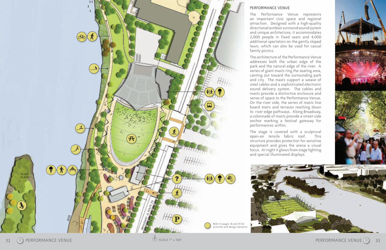
The Performance Venue represents an important civic space and regional attraction. Designed with a high-quality directional outdoor surround sound system and unique architecture, it accommodates 2,000 people in fixed seats and 4,000 additional spectators on the gently sloped lawn, which can also be used for casual family picnics.
The architecture of the Performance Venue addresses both the urban edge of the park and the natural edge of the river. A series of giant masts ring the seating area, canting out toward the surrounding park and city. The masts support a weave of steel cables and a sophisticated electronic sound delivery system. The cables and masts provide a distinctive enclosure and sense of space to the Performance Venue. On the river side, the series of masts line board stairs and terraces reaching down to river edge pathways. Along broadway, a colonnade of masts provide a street-side anchor marking a festival gateway for performances within.
The stage is covered with a sculptural open-air tensile fabric roof. This structure provides protection for sensitive equipment and gives the arena a visual focus. At night it glows from stage lighting and special illuminated displays.
? FM t
SCALE 1” = 100’N
PERFORMANCE VENUE
FM
b
G
v
Refer to pages 18 and 19 for activities and design elements
D D

34 35
STRUCTURAL DIAGRAMS
SECTION LOOKING EAST
GARDEN MARKET AND EVENT SPACELAWN SEATINGSTAGE FIXED SEATING
PERFORMANCE VENUE AT RIVER
SCALE 1” = 40’ OUTDOOR PERFORMANCE VENUE AND LAWN OUTDOOR PERFORMANCE VENUE AND LAWND D
PERFORMANCE VENUE AT NIGHT
BROADWAY AS IT ENGAGES THE PERFORMANCE VENUE
VIEW LOOKING SOUTHEAST
VIEW LOOKING OVERHEAD
VIEW LOOKING NORTHEAST

36 37
?
G
?
?
INDIAN CREEK WETLAND / ENVIRONMENTAL CENTER
5 G
5 G
bRO
AD
WA
Y (I
L RO
UTE
25)
INDIAN CREEK WETLAND/ENVIRONMENTAL EDUCATION CENTER
Indian Creek is a tributary of the Fox River and the site of a historic Native American hunting ground. Though it now flows through a densely urbanized area, its waters remain very clean. The mouth of the stream was substantially filled in over the years creating a narrow channel where there was once a wide wetland. This wetland has been restored to its pristine pre-settlement state.
Re-creation of the wetland at Indian Creek offers several benefits, including the reduction of silt runoff from the stream into the Fox and providing a native natural landscape for urban wildlife.
The wetland features natural habitat areas, trails, boardwalks, bridges and interpretive signage. The Indian Creek Environmental Education Center hosts exhibits related to the community and the environment.
The Indian Creek Wetland functions as an accessible urban wildlife area. boardwalks carry visitors through the restoration project, which is attractive to wildlife and people alike.
Visitors to the wetland will experience nature up close with the city just steps away. This wetland and affiliated Environmental Education Center showcases Aurora’s natural history.
VETERANS ISLAND
This island at the north end of the park is adjacent to Indian Creek. The island is accessible via Illinois Avenue and a non-motorized bridge connecting it to the Indian Creek Wetland and Environmental Education Center. The island’s harbor provides launch areas for small boats and access for ice skating in the winter.
FOX RIVER
INDIAN CREEK
VETERANS ISLAND
NSCALE 1” = 100’ INDIAN CREEK WETLAND / ENVIRONMENTAL CENTERE E
PIERCE STREET
J
FM?
?
b
J
VETERANS ISLAND
FOX RIVER
Refer to pages 18 and 19 for activities and design elements

38 39
SECTION LOOKING NORTH
INDIAN CREEKWETLAND
SCALE 1” = 40’
RIVER WALKWETLAND
PATH
PATH
INDIAN CREEK WETLAND / ENVIRONMENTAL CENTER INDIAN CREEK WETLAND / ENVIRONMENTAL CENTERE E
TYPICAL BOARDWALK THROUGH THE INDIAN CREEK WETLAND

40 41
The RiverEdge Park represents a strong collaborative effort among the public and private sectors, including
business people, environmental advocates and developers. We fully understand the dynamic nature of this vision, and expect that, as the park comes to life, new elements and activities will be introduced
over time. All who have been involved in the design and dream for this park believe wholly that it is a gift
to the future of our community and the region.
CONCLUSION

42 43
44 ACKNOWLEDGEMENTS
Christopher b. burke Engineering Ltd. EngineersTerry Guen Associates, Inc,Landscape ArchitectureMuller&Muller, LtdArchitectsEdward K. UhlirPark Design and Management ConsultingLand and Water Resources, IncWetland Design and Management
ACKNOWLEDGEMENTS
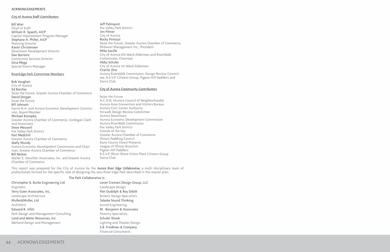
City of Aurora Staff Contributors
bill WietChief of StaffWilliam K. Spaeth, AICPCapital Improvement Program ManagerStephane A. Phifer, AICPPlanning DirectorKaren ChristensenDowntown Development DirectorDan barreiroCommunity Services DirectorGina MogaSpecial Events Manager
RiverEdge Park Committee Members
bob Vaughan City of AuroraEd bonifasSeize the Future, Greater Aurora Chamber of CommerceDavid Dorgan Seize the Future bill JohnsonHarris N.A. and Aurora Economic Development Commis-sion, board MemberMichael Konopka Greater Aurora Chamber of Commerce, Cordogan Clark and AssociatesSteve MesserliFox Valley Park DistrictPatt Medchill Greater Aurora Chamber of CommerceWally MundyAurora Economic Development Commission and Chair-man, Greater Aurora Chamber of Commercebill Nelson Walter E. Deuchler Associates, Inc. and Greater Aurora Chamber of Commerce
Jeff PalmquistFox Valley Park DistrictJim PilmerCity of Aurora Rocky Pintozzi Seize the Future, Greater Aurora Chamber of Commerce, Midwest Management Inc., PresidentMike SavilleCity of Aurora 6th Ward Alderman and RiverWalk Commission, ChairmanAbby Schuler City of Aurora 1st Ward AldermanCharlie ZineAurora RiverWalk Commission, Design Review Commit-tee, R.S.V.P. Citizens Group, Pigeon Hill Paddlers and Sierra Club
City of Aurora Community Contributors
Seize the FutureA.C.O.N. (Aurora Council of Neighborhoods)Aurora Area Convention and Visitors bureau Aurora Civic Center AuthorityForwalk Design Review CommitteeAurora DowntownAurora Economic Development CommissionAurora RiverWalk CommissionFox Valley Park DistrictFriends of the FoxGreater Aurora Chamber of CommerceIllinois Paddling CouncilKane County Forest PreserveLeague of Illinois bicyclistsPigeon Hill PaddlersR.S.V.P. (River Shore Vision Plan) Citizens GroupSierra Club
This report was prepared for the City of Aurora by the Aurora River Edge Collaborative, a multi disciplinary team of professionals formed for the specific task of designing the new River Edge Park described in this master plan.
The Park Collaborative is:Lenet Crestani Design Group, LLCLandscape DesignPiet Oudolph & Roy Diblikbotanic Design SpecialistsTalaske Sound ThinkingSound EngineeringM. benjamin & AssociatesForestry SpecialistsSchuler ShookLighting and Theater DesignS.b. Friedman & CompanyFinancial Consultants

SCALE 1” = 300’RIVER EDGE PARK MASTER PLANCity of AurorA • 44 EAst DownEr PlACE • AurorA, il 60505 • www.AurorA-il.org
INDIAN CREEK
LAKE ST
REET (IL
ROUTE 31
)
wEst PA
rK AVE ILLINO
IS AVE
PIERCE ST
BroADwAy (il routE 25)
SPRIN
G ST
nEw
yo
rK
st
RIVER ST
GA
LENA
BLVD
Do
wn
Er Pl
BENTO
N ST
STOLP AVE
VETERANSISLAND
BLUES ISLAND
fOx RIVER
MCCULLOUGh PARK
PLUM
ST
VIN
E ST
CED
AR
ST
SPRU
CE ST
STOLP ISLAND
10
9
8
6
7
4
1
2
5
3
NO
RTh A
VE
foXwAlK MAstEr PlAnN
RIVER EDGE PARK MASTER PLAN
Significant future Development
Existing Buildings
Landmark Buildings
New Green Space
Existing & future Green Space
1] Aurora Public Library 2] scitech Museum3] Aurora City hall4] Paramount theatre5] fox island Place6] Casino7] Aurora Regional fire Museum8] AtC & roundhouse9] fox Metro reclamation Bldg.10] u.s. Post office