A RESOURCE BOOK ON PARTICIPATORY GEOGRAPHIC …...Tools for Development Workers: Advocacy, Agrarian...
82
A RESOURCE BOOK ON PARTICIPATORY GEOGRAPHIC INFORMATION SYSTEM (PGIS) FOR LAND RIGHTS ADVOCATES Volume 1 L a n d W a t c h A s i a
Transcript of A RESOURCE BOOK ON PARTICIPATORY GEOGRAPHIC …...Tools for Development Workers: Advocacy, Agrarian...

A RESOURCE BOOK ON PARTICIPATORY GEOGRAPHIC INFORMATION SYSTEM (PGIS)
FOR LAND RIGHTS ADVOCATES Volume 1
La
nd Watch Asia
Founded in 1979, ANGOC is a regional association national and regional networks of non-government organizations (NGOs) in Asia actively engaged in food security, agrarian reform, sustainable agriculture, participatory governance and rural development. ANGOC network members and partners work in 14 Asian countries with an effective reach of some 3,000 NGOs and community-based organizations (CBOs). ANGOC actively engages in joint field programs and policy debates with national governments, intergovernmental organizations (IGOs), and international financial institutions (IFIs). ANGOC is the convenor of the Land Watch Asia (LWA) campaign and the Asian Alliance Against Hunger and Malnutrition (AAHM-Asia). ANGOC is also a member of the International Land Coalition (ILC), the Global Land Tool Network (GLTN), Global Forum on Agricultural Research (GFAR), and the Indigenous Peoples’ and Community Conserved Territories (ICCA) Consortium.
Asian NGO Coalition for Agrarian Reform and Rural Development 33 Mapagsangguni Street, Sikatuna Village, Diliman, 1101 Quezon City, Philippines P.O. Box 3107, QCCPO 1101, Quezon City, Philippines Tel.: +63-2 3510581 | Fax: +63-2 3510011 E-mail: [email protected] | URL: www.angoc.org
PAFID is a social development organization which has been assisting Philippine indigenous communities to secure or recover traditional lands and waters since 1967. It forms institutional partnerships with indigenous communities to secure legal ownership over ancestral domains and to shape government policy over indigenous peoples’ issues. PAFID works exclusively with the indigenous peoples’ sector, specifically upon written or signed requests for assistance from indigenous communities or their representatives. PAFID envisions indigenous communities as responsible stewards of their resources.
As communities and individuals, they possess rights and responsibilities over the natural environment, cultural integrity, educational, and health systems that embody their indigenous knowledge and mores, employ socially and ecologically sound methods of managing and utilizing their natural resources for their own and national benefit for both present and future generations.
Philippine Association for Intercultural Development (PAFID)71 Malakas Street Quezon City, PhilippinesTel: +63-2 927 4580Fax: +63-2 435 5406Email: [email protected]/[email protected]: http://www.pafid.org.ph/

A RESOURCE BOOK ON PARTICIPATORY GEOGRAPHIC INFORMATION SYSTEM (PGIS)
FOR LAND RIGHTS ADVOCATES
Volume 1
Production Team:Inputs and materials assembled by Gregorio L. QuitangonLayout by Gerard Jerome DumlaoCover design and illustrations by Christine Mae Santos
Editorial Team: Fr. Francis B. Lucas David Benjamin De VeraNathaniel Don MarquezMarianne Jane NaungayanKail Zingapan
Photo Credits: Unless otherwise stated, all photographs used in this publication were provided by PAFID.
Publishers:ANGOC and PAFID
Citation:Asian NGO Coalition for Agrarian Reform and Rural Development (ANGOC) and Philippine Association for Intercultural Development (PAFID) (2018). A resource book on participatory geographic information system (PGIS) for land rights advocates. Vol. 1. Quezon City: ANGOC and PAFID with support of the International Land Coalition (ILC).
This publication was made possible with the support of the International Land Coalition (ILC). The views presented in this publication do not necessarily reflect the views of ILC.
Title Page
List of Acronyms Used
Preface
Foreword
What is this Resource Book about?
Chapter 1: Development Context
A. Prevailing issues on land rights in AsiaB. The Indigenous Peoples in the PhilippinesC. The Development of National Spatial Database
in the Philippines Box 1: Case Study of the Tampakan Mining Project in South Cotabato, Mindanao
Chapter 2: Participatory Mapping
A. IntroductionB. What is Participatory Mapping?C. Relevance of Participatory MappingD. Different Types of Participatory MappingE. Basic Concepts of PGIS
1. What is PGIS? 1. Brief History of PGIS2. Significance of PGIS3. Prospects and Challenges for PGIS
Application4. PGIS in Practice
Box 2: Participatory Resource Valuation Research Using PGIS: An initiative by Farming Communities in Nueva Vizcaya
TABLE OF CONTENTSTABLE OF CONTENTS
iii
7
9
11
13
17
182026
28
31
323334353939394042
4446
Chapter 3: Geographic Information System (GIS) Technology
A. Definition and Significance of GISB. Advantages of GISC. Components of GISD. GIS Work Flow
Chapter 4: PGIS Practice in the Philippines
A. PGIS Components and RequirementsB. PGIS Operational Framework Box 3: Box 3: Reclaiming Ancestral Domains in the Philippines through PGIS
Other References
51
52535459
63
646670
77
ADSDPP
ANGOC
AOBLGUCADT CBD CENRO
CLUPCSODAO DENRENROFGDFLUPFPICGISGPSICCAsICCIECILC IPIPRAIUCNLGUMPDONCIPNGO
LIST OF ACRONYMS USED
Ancestral Domain Sustainable Development and Protection PlanningAsian NGO Coalition for Agrarian Reform and Rural Developmentadministrative orderbarangay local government unitCertificate of Ancestral Domain TitleConvention on Biological DiversityCommunity Environment and Natural Resource OfficerComprehensive Land Use Plancivil society organizationDepartment Administrative OrderDepartment of Environment and Natural ResourcesEnvironment and Natural Resource Officerfocus group discussionForest Land Use Planfree prior and informed consentGeographic Information SystemGlobal Positioning SystemIndigenous and Community Conserved AreasIndigenous Cultural Communityinformation, education, and communicationInternational Land Coalitionindigenous peopleIndigenous Peoples’ Rights ActInternational Union for Conservation of Naturelocal government unitMunicipal Planning and Development OfficerNational Commission on Indigenous Peoplesnon-government organization
7

PAFID PGIS P3DMPRS 92PoWPaRATWG UNDRIP
Philippine Association for Intercultural DevelopmentParticipatory Geographical Information System Participatory 3D-ModellingPhilippine Reference System of 1992Program of Work on Protected AreasRepublic ActTechnical Working GroupUnited Nations Declaration on the Rights of Indigenous Peoples
8

This resource book is part of a two-volume publication which aims to equip the users with the necessary knowledge,
attitude and skills on Community Mapping and Participatory Geographic Information System (PGIS). It focuses on data collection, database management, data processing, and analysis for the production of digital maps useful in advancing the land rights agenda of rural communities, particularly indigenous communities and smallholder farmers in Southeast Asia.
The resource book is intended for land rights defenders, institutions advocating for land rights, development practitioners, and communities to defend their rights to land and the sustainable use of natural resources. This publication is designed to impart the key concepts of community mapping and the basics of PGIS, with the view that the application of PGIS technology contributes to securing legal recognition of the indigenous communities over their traditional territories and resources.
This resource book is not prescriptive nor does it intend to cover the full range of the PGIS, but aims to contribute to the empowerment of communities in protecting and defending their right to land. As this resource book is a general guide on PGIS, readers need to be mindful of the legal procedures and requirements for the submission of community maps for registration and legal recognition. In the Philippines, the PGIS has been useful in establishing and enhancing the right to self-determination by the indigenous tribes over their ancestral domains, through the opportunity provided by the Indigenous People’s Rights Act (IPRA).
PREFACEPREFACE
9

The production of this resource book is based on the collective experiences of PAFID in its initiatives with partner communities, with the support of Misereor and the International Land Coalition (ILC). This knowledge sharing is complemented by the analysis of the Asian NGO Coalition for Agrarian Reform and Rural Development (ANGOC) on land rights in the region. It augurs with the view that sharing the principles, methods and lessons behind the pioneering work of PAFID need to be extracted, synthesized and shared across geographic boundaries.
This resource book is based on PAFID’s and ANGOC’s work on land rights and on secondary written materials. This resource book has no copyright and readers are encouraged to translate, adapt and share its contents to a broader audience.
Our appreciation goes to ILC for supporting the production and printing of this resource book. Finally, our thanks to the production team: Gregorio L. Quitangon for putting the materials together, Gerard Jerome Dumlao for the desktop services and Christine Mae Santos for the original artwork as well as the various sources of the illustrations used in this resource book.
Fr. Francis B. LucasChair Emeritus of ANGOC and Chair of PAFID
10
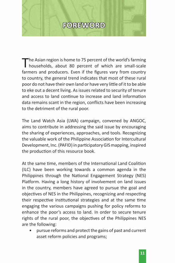
The Asian region is home to 75 percent of the world’s farming households, about 80 percent of which are small-scale
farmers and producers. Even if the figures vary from country to country, the general trend indicates that most of these rural poor do not have their own land or have very little of it to be able to eke out a decent living. As issues related to security of tenure and access to land continue to increase and land information data remains scant in the region, conflicts have been increasing to the detriment of the rural poor.
The Land Watch Asia (LWA) campaign, convened by ANGOC, aims to contribute in addressing the said issue by encouraging the sharing of experiences, approaches, and tools. Recognizing the valuable work of the Philippine Association for Intercultural Development, Inc. (PAFID) in participatory GIS mapping, inspired the production of this resource book. At the same time, members of the International Land Coalition (ILC) have been working towards a common agenda in the Philippines through the National Engagement Strategy (NES) Platform. Having a long history of involvement on land issues in the country, members have agreed to pursue the goal and objectives of NES in the Philippines, recognizing and respecting their respective institutional strategies and at the same time engaging the various campaigns pushing for policy reforms to enhance the poor’s access to land. In order to secure tenure rights of the rural poor, the objectives of the Philippines NES are the following:
• pursue reforms and protect the gains of past and current asset reform policies and programs;
FOREWORD
11
• address inter-sectoral concerns on land and future legal frameworks;
• enhance the basic sectors’ capacities to demand and defend their rights and natural resources;
• develop a comprehensive and coherent land data system; and,
• enhance coordination among ILC members in the Philippines.
Towards this end, PAFID organized a four-day course on “GIS Tools for Development Workers: Advocacy, Agrarian Reform and Indigenous Peoples” (18-21 April 2017; Quezon City, Philippines), participated in by members of the NES platform, to fully understand the basic concepts of mapping and spatial data collection and management. Most of the resource materials in the said training course have been used as inputs to this publication.
This resource book is a work-in-progress, and offers additional tools for protecting land rights and in addressing inter-sectoral concerns on land governance. It also equips NES partners and the broader CSO community in producing interactive maps depicting the overlays of the different major tenurial arrangements and land uses. As in the case of the Philippines, such maps will serve as evidenced-based tool for land rights advocacy in favor of the basic sectors while lobbying for the bills on National Land Use Act (NLUA), Notice of Coverage (NOC) and Indigenous Community Conserved Areas and Territories (ICCA).
Nathaniel Don E. MarquezExecutive DirectorANGOC
12
WHAT IS THIS RESOURCE BOOK ABOUT?
Origin of PGIS
Securing tenure over the land, seas and other natural resources lies at the heart of the indigenous communities’ demands in
the local level all the way to their advocacy in the global arena. Their lack of control, access over natural resources and non-recognition and respect of their rights over their territories affect their daily lives, cause extreme poverty, and impact on their survival as a distinct community. Thus, in the past 10 years, the demand for tenure over land and resources has been the central feature of at least 143 declarations of indigenous peoples worldwide. The passage of the UN Draft Declaration on the Rights of Indigenous Peoples is expected to intensify the advocacy of indigenous communities worldwide for the recognition of their rights over their traditional territories.
In this context, a broad partnership of indigenous coalitions and land rights and research organizations launched the LandMark in 2015, the first online, interactive global platform map lands collectively held and used by indigenous peoples and communities.
The platform was created to fill a critical gap in indigenous and community rights and make clear that these lands are not vacant, idle, or available to outsiders. It recognizes the fact that indigenous communities often lack the legal rights to their land and can be pushed aside by the exploitative development of natural resources, such as mining operations, palm oil plantations, and timber concessions.
13

LandMark was conceptualized in support to research and advocacy to provide convincing evidence that indigenous peoples and local communities are good stewards of their land and natural resources, keeping carbon in the trees and the ground, and thus slowing climate change.
The international talks addressing climate change, however, are building towards a treaty conference in Paris but have yet
to include indigenous peoples’ land rights as an agreed-upon tool to limit the amount of carbon that human activity releases into the atmosphere.
“To us, the detailed mapping of our ancestral territories, led by local indigenous communities, help us articulate our constitutionally recognized rights,” said Abdon Nababan, then Secretary-General of the Indonesia’s Indigenous Peoples’ Alliance of the Archipelago (AMAN). “But these maps do us no good unless they become public knowledge and indigenous rights are recognized by all who have ambitions to grab our lands, and these rights are actively protected by government. LandMark is an
important tool for us in the process of gaining legal recognition of our constitutional rights.”
Scope and Limitations of this resource book
The contents of this book are drawn from PAFID’s work based on Philippine field experiences.
Since this resource book is content-sensitive, it recognizes the varying conditions and local situations of rural communities across the globe. The users of this manual are encouraged to look for other resources available online for the open source GIS software application.
14
“LandMark was conceptualized in support to research and advocacy to provide convincing evidence that indigenous peoples and local communities are good stewards of their land and natural resources...”

How to Use this Resource Book
Users of this resource book may tap it as a reference material in its entirety or focus on specific sections and topics which may be relevant to their particular needs. The methods discussed in this publication are structured in such a way that these may also be further adjusted and refined to suit the user’s needs and local conditions.
Basically, this resource book is organized into four major themes as shown below:
Chapter 1: Development Context discusses the importance of understanding the complex problems and issues impinging upon the development of rural communities in Asia, and in particular, small farmers, upland dwellers, and indigenous peoples in the Philippines.
Chapter 2: Participatory Mapping highlights the significant contribution of map making in human history, particularly in community development work, that promote people’s participation and empowerment. Several forms of mapping techniques and participatory approaches can be used as strategies for community participation in pursuing land rights agenda for the rural poor communities consistent with sustainable development principles.
Chapter 3: Geographic Information System (GIS) is a computerized mapping technology which has been widely accepted and adopted worldwide by land rights defenders and institutions advocating for land rights in favor of the disadvantaged sectors. This section describes the basic components and workflow of GIS.
Chapter 4: PGIS Practice in the Philippines discusses the fusion of traditional mapmaking techniques with computerized mapping through the use of PGIS technology in a simple and
15
easy way. Once the task of professional consultants, the skills of PGIS technology have been acquired by CSO workers in the Philippines to make digital maps, and they are now continuously training community partners to do community profiling, field surveying, interviewing of key informants, and map-making based on their collective experiences. It is hoped that through capacity building with particular interest on map-making, increasing access to land and the sustainable use of natural resources can be fully realized by the disadvantaged sectors.
Enjoy reading!
David Benjamin De VeraExecutive Director PAFID
16

CHAPTER 1:DEVELOPMENT
CONTEXT
17

CHAPTER 1:DEVELOPMENT CONTEXT
A. Prevailing issues on land rights in Asia
In the 2014 report of the State of Food Insecurity prepared by Food and Agriculture Organization (FAO), International
Fund for Agricultural Development (IFAD), and World Food Programme (WFP), more than 65 percent of the world’s undernourished and hungry are found in Asia. Majority of this figure is represented by the marginalized sector, including the small farmers and indigenous peoples.
Despite their significant contribution in achieving global food security and biodiversity conservation, small farmers and indigenous peoples are often disadvantaged due to limited awareness of their rights and the prevalence of discrimination in many parts of the region. Thus, they are unable to counter the claims of political and economic powers, and wisely evaluate contracts of the private sector in utilizing their territorial resource.
Similarly, while international, regional, and national legal bases are in place on upholding redistributive lands and resource justice to these sectors, they are still often weakly safeguarded and rarely provided with full enjoyment of such rights.
In Bangladesh, indigenous peoples of the Chittagong Hill Tracts (CHT) and the 18 ethnic communities in the plains are privileged to own their indigenous territories as identified by the State Acquisition and Tenancy Act of 1950. However, majority of communities in the plains are not accorded with similar rights.
18

Despite laws upholding indigenous peoples’ territorial rights, their customary lands are still being leased out to the private sector by the government, resulting to conversion of these lands for economic use and alienating the people in the process.
Such dismal state of IP affairs is attributed to the severely limited laws on land ownership, which are often focused solely on holding, transfer, purchase, and acquisition of land. While the CHT Accord shall safeguard the indigenous people’s land rights through recognition of their traditional ownership rights and management of land, and through provision of land dispute resolution; the trend of land alienation in both the plains and the hills still continues (Ripa and Tripura, 2014).
While good laws on indigenous people’s protection of rights are in place, weak implementation will always be an issue in most of Asia’s third world countries.
Another pressing concern on land in the Asian context is the overlapping interests among various stakeholders, including the environment sector, in the proper use of lands. Conflicts in resource use not only arise between and among social and economic interest groups, but also with the government in the pursuit of preservation and conservation of the environment. In India, large areas of land were declared as protected areas from 1970 to 2000, causing massive evictions of communities leading to protest actions against the government (AVARD, 2014). This is also evident in the Philippines with the overlapping provisions of the Indigenous Peoples Rights Act (IPRA) and the National Integrated Protected Areas System (NIPAS) Act.
To date, there are still Asian countries lacking laws on the protection of rights of indigenous peoples. Instead, these countries are implementing national policies biased towards commercial agribusiness or extractive ventures. The Corporate Agriculture Farming policy of Pakistan remains a mechanism
19

to favor foreign investors at the expense of local communities (SCOPE, 2014).
These multi-faceted concerns lead to land disputes, evictions, and even killings, resulting to human rights violations against farmers and indigenous communities. In Indonesia, there have been 1,520 agrarian conflicts that occurred between 2004 to 2014, covering more than 6.5 billion hectares and affecting 977,103 households. This translates to an average of two agrarian conflicts, 1,792 hectares of lands grabbed, which involved 267 households per day. Within a ten-year period, this has resulted to 85 people killed, 743 injured from physical violence, and 1,395 arrested (Nurdin, 2014). In Nepal, due to land disputes, thousands of families were harassed with 760 families being forcibly evicted from their lands (Basnet, 2014). B. The Indigenous Peoples in the Philippines1
Indigenous peoples are defined as “a group of people or homogenous societies identified by self-ascription and ascription by others, who have continually lives as organized communities on community-bounded and defined territory, and who have, under claims of ownership since time immemorial, occupied, possessed and utilized such territories, sharing common bonds of language, customs, traditions and other distinctive cultural traits, or who have, through resistance to political, social and cultural inroads of colonization, non-indigenous religions and cultures, become historically differentiated from the majority of the Filipinos” (IPRA Chapter II Section 3h). They comprise 10-20 percent of the country’s population (IWGIA, 2016) distributed into approximately 110 different ethno-linguistic groups (Pedragosa, 2012). Majority of them reside in the uplands with the remaining biodiverse
1 Condensed from The Indigenous Peoples in the Philippines: A Background by David Benjamin de Vera and Shirley Libre of the Philippine Association for Intercultural Development (PAFID).
20
ecosystems they claim as part of their ancestral domain (AD)2 which cover nearly 25 percent of the total country’s land area.
Fifty-five percent of the Key Biodiversity Areas (KBAs) – which represent the most important sites for biodiversity conservation in the country (IUCN, 2011) – overlap with ancestral domain titles. Further, 90 percent of all the remaining forest cover in the Philippines are in ancestral domain areas. Clearly, indigenous communities, through their traditional resource management systems, play a vital role in protecting and governing the use of these resources in sustaining people’s needs for survival; and hence should be respected and recognized.
However, indigenous peoples continue to face complex struggles which impede their full enjoyment of legal rights. While their ancestral domains contain valuable resources, indigenous peoples are often disadvantaged because of their lack of tenurial security.
Unabated encroachments in the uplands pose a threat to the environment and the IP’s welfare
With increasing population and demand for the use of land and forest resources, lowland families migrate to the uplands, and economic activities encroach in the ancestral domains. Among the mix of stakeholders who are in strong competition with the use of the uplands, indigenous people are in a most
21
2 Ancestral domains are defined as “all areas generally belonging to ICCs/IPs comprising lands, inland waters, coastal areas, and natural resources therein, held under a claim of ownership, occupied or possessed by ICCs/IPs, themselves or through their ancestors, communally or individually since time immemorial, continuously to the present except when interrupted by war, force majeure or displacement by force, deceit, stealth or as a consequence of government projects or any other voluntary dealings entered into by government and private individuals or corporations, and which are necessary to ensure their economic, social, and cultural welfare. It shall include ancestral land, forests, pasture, residential, agricultural, and other lands individually owned whether alienable and disposable or otherwise, hunting grounds, burial grounds, worship areas, bodies of water, mineral and other natural resources, and lands which may no longer be exclusively occupied by ICCs/IPs but which they traditionally had access to for their subsistence and traditional activities, particularly the home ranges of ICCs/ IPs who are still nomadic and/or shifting cultivators” (RA 8371 Chapter 2, Sec. 3a).
vulnerable state as most of the remaining natural resources and ecosystem services crucial in sustaining human needs, such are watersheds, are found within their territories.
Indigenous livelihoods are also adversely affected and most of the traditional cultivation sites and fallow areas, in particular, have now been degraded and are further threatened by the influx of migrant farmers, who have introduced unsustainable lowland commercial farming practices.
Limited access to basic services and opportunities
As settlements of indigenous peoples are often located in remote areas, they suffer from limited to lack of access to basic social services and economic opportunities, resulting to higher incidence of morbidity, mortality, and malnutrition. Illiteracy, unemployment, and poverty rates are also much higher in IP communities than in the rest of the population.
Under-representation in the Philippine governance
The IPs remain among the most under-represented sectors in the governance of the Philippines. Without the necessary wherewithal, the sector has not been able to actively participate in political exercises and merely settle for token representation in the legislature and other elective posts in the government. Available opportunities for participation in policy-making are limited by the sector’s capacity to engage the bureaucracy and the ruling political elite.
Overlapping laws infringing the rights of IPs
The Philippines holds the distinction of being the first country in Southeast Asia to enact a law recognizing the traditional rights of indigenous people over ancestral domains, with the passage of Republic Act 8371 or the IPRA.
22

Through the IPRA, the Philippines has been complying with the treaty it has signed on the Convention on Biodiversity (CBD), laying internationally-accepted standards on the protection of the rights and welfare of IPs in the conservation of natural resources within their territories. Although, the country has yet to ratify the international treaty on International Labour Organization Convention 169 (ILO) – providing for the basic standards to protect indigenous workers within the framework of respect for indigenous and tribal peoples’ cultures, their distinct ways of life, and their traditions and customs.
As of 2015, the NCIP has issued 158 CADTs and 258 CALTs covering more than 4 million hectares or 14 percent of the nation’s total land area.
But due to the sectoral approach in crafting policies in the Philippines, provisions of different land laws are not harmonized. Hence, attempts to address differing sectors’ needs may have negative implications to one another.
Republic Act 8371 or the National Integrated Protected Areas (NIPAS) Act, passed in 1992, establishes all designated protected areas to maintain essential ecological processes and life-support systems to preserve genetic diversity, ensure sustainable use of resources found therein, and maintain their natural conditions to the extent possible (RA 8371, Section 4). Under the 1987 Constitution, the NIPAS Act is the first law expressly defined for indigenous cultural communities. It also provides accorded recognition to ancestral lands and customary rights arising, and mandates that government shall “have no power neither to evict indigenous communities from their present occupancy nor resettle them to another area without their consent” (RA 8371, Section 13).
Despite this recognition, there has been resistance and criticism from the IP sector regarding the scope and coverage of the law, as most of the national parks and protected areas are situated
23
within traditional lands and territories. Many communities decry the establishment of new governance structures, such as the Protected Area Management Board (PAMB) and the formulation of Protected Area Management Plans, as an expression of disrespect and infringement on their rights as the ‘owners’ of the land.
While the Philippines has undergone a transition from agriculture to manufacturing-based economy, laws were enacted to support, enhance, encourage, and provide incentives to industries that shall generate the necessary revenues needed by the government to jumpstart its economy. As mining was deemed to be the most effective way to generate the needed revenues for the Philippines, the Government, along with the mining industry, worked for the passage of Republic Act 7942 or the Philippine Mining Act of 1995 as response to the growing demand of foreign investors for reduced uncertainties in the industry (Ali, 2003; Gomez, 2012; Vivoda; 2008 as cited in Camba, 2016). It governs foreign investors for a 100 percent ownership of mining activities under an agreed contract, which includes full exploration, development, and extraction in the area. It was a major priority throughout the terms of three Presidents – Fidel Ramos, Joseph Estrada, and Gloria Macapagal-Arroyo. The government even adopted the official line that “mining shall be the main driver of development for the new millennium.”
During Macapagal-Arroyo’s administration, there were 180 Mineral Production Sharing Agreements, 70 Industrial Sand and Gravel Permits, 126 Exploration Permits, and five Special Mineral Extractions permits approved by 2005. And by 2010, the Philippines had the second largest world explorations sites in the Asia-Pacific region (World Investment Report, 2007 as cited in Camba, 2016). This law had the biggest impact on the land rights of indigenous peoples.
Majority of the mining applications and operations are found within ancestral domains and environmentally-critical areas
24

and consequently, serious conflicts have arisen due to the establishment of a parallel and more powerful governance structure by mining corporations. Unfortunately, public or government maps do not show these overlaps of mining tenements with the indigenous lands.
Following a long history of foreign colonization in the Philippines, Republic Act 7227 or the Bases Conversion Act of 1992 was enacted mandating the conversion of American military bases in the country into other productive uses to promote economic development in Central Luzon, and thus creating the Subic Special Economic Zone, Subic Base Metropolitan Authority (SBMA), and the Clark Special Economic Zone. This law paved the way for the growth of more Special Economic Zones or ECOZONES3, through the enactment of Republic Act 7196 or the Special Economic Zone Act of 1995.
The first ECOZONES in the country were established in ancestral domains; and similar to the case of the Mining Act, new and more powerful governance structures and planning modalities were put in place, which supplanted the existing traditional leadership structures and resource management arrangements of the affected indigenous communities. Moreover, these ECOZONES did not recognize the rights and ownership of the IPs over their ancestral domains.
Weak implementation of IPRA
While IPRA is seen as the most radical policy reform as regards to tenurial security of indigenous peoples, there has been difficulty in enforcing and implementing many of the progressive provisions of the IPRA, mainly due to the unfamiliarity of many state actors along CSO workers who are expected to advocate for the law and provide support to IP communities. 3 ECOZONES are selected areas in the country that are transformed into highly developed
agro-industrial, tourist/recreational, commercial, banking, investment, and financial centers, and where highly-trained workers and efficient services will be made available to commercial enterprises.
25
Many IP communities are also unaware of their bundle of rights. This is where the business sectors take advantage and exploit the loopholes of the free, prior, and informed consent (FPIC) processes and requirements as institutionalized to the IPs by the law.
Indigenous communities also face the negative notion that they do not have the capacity to manage large tracts of lands; hence, claiming their rights over ancestral territories becomes a challenge.
C. The Development of National Spatial Database in the Philippines
Indigenous communities are at the frontline of preserving and defending the remaining forests from degradation as land use conflicts escalate. About 70 percent of the Key Biodiversity Areas (KBAs) of the Philippines are located within traditional lands and territories of ICCs.
Of the estimated four million hectares of ancestral domains, only about half (two million hectares) have been mapped, delineated, and titled. The remaining two million hectares are characterized by numerous existing land use conflicts within the ancestral domains. These include encroachment of mining or other extractive industries, and coverage of other tenurial instruments (i.e., CLOAs for agrarian reforms, TLAs/FLAs for timber and logging, energy projects, and tourism areas).
The lack of systematic collection, archival and access to reliable and accurate maps are preventing indigenous communities in making informed decisions, particularly in the process of FPIC. In turn, the absence of a genuine and meaningful FPIC often leads to social division and cultural displacement for IPs.
While there are case studies featuring best practices of community development initiatives as well as field reports on
26
the violations of IP rights, there is a need to complement the advocacy efforts with evidence-based spatial data, specifically maps that clearly outline the land-use conflicts.
In this context, the development of a National Digital Spatial Database in the Philippines was developed, aimed at producing an online, interactive portal of spatial data and maps, showing, among others, the overlays of different major tenurial arrangements and land uses. The national database shall be utilized in the production of maps as evidences to advocacies in addressing land tenure issues in the country. n
27
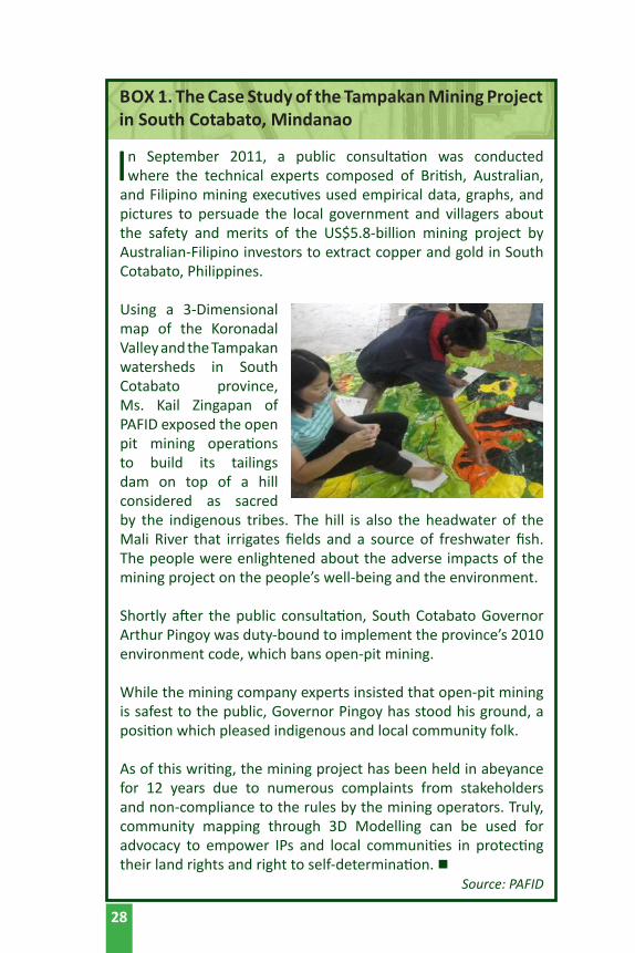
In September 2011, a public consultation was conducted where the technical experts composed of British, Australian,
and Filipino mining executives used empirical data, graphs, and pictures to persuade the local government and villagers about the safety and merits of the US$5.8-billion mining project by Australian-Filipino investors to extract copper and gold in South Cotabato, Philippines. Using a 3-Dimensional map of the Koronadal Valley and the Tampakan watersheds in South Cotabato province, Ms. Kail Zingapan of PAFID exposed the open pit mining operations to build its tailings dam on top of a hill considered as sacred by the indigenous tribes. The hill is also the headwater of the Mali River that irrigates fields and a source of freshwater fish. The people were enlightened about the adverse impacts of the mining project on the people’s well-being and the environment.
Shortly after the public consultation, South Cotabato Governor Arthur Pingoy was duty-bound to implement the province’s 2010 environment code, which bans open-pit mining.
While the mining company experts insisted that open-pit mining is safest to the public, Governor Pingoy has stood his ground, a position which pleased indigenous and local community folk.
As of this writing, the mining project has been held in abeyance for 12 years due to numerous complaints from stakeholders and non-compliance to the rules by the mining operators. Truly, community mapping through 3D Modelling can be used for advocacy to empower IPs and local communities in protecting their land rights and right to self-determination. n
Source: PAFID
BOX 1. The Case Study of the Tampakan Mining Project in South Cotabato, Mindanao
28

References:
Association of Voluntary Agencies for Rural Development (AVARD). 2014. Scoping study on indigenous peoples (Scheduled Tribes of India). AVARD. [Paper submitted to ANGOC for Land Watch Asia scoping studies on indigenous peoples].
Basnet, J. (2014). 2013/2014 CSO Land reform monitoring report. Community Self-Reliance Centre (CSRC). [Paper submitted to ANGOC for Land Watch Asia 2014 Land Monitoring Report].
Camba, A. A. (2016). Philippine mining capitalism: The changing terrains of struggle in the neoliberal mining regime. ASEAS – Austrian Journal of South-East Asian Studies, 9(1), 69-86.
De Vera, D. and Libre, S. (2014). The indigenous peoples in the Philippines: A background. Philippine Association for Intercultural Development (PAFID). [Paper submitted to ANGOC for Land Watch Asia scoping studies on indigenous peoples].
FAO, IFAD, and WFP. (2014). The state of food insecurity in the world 2014: Strengthening the enabling environment for food security and nutrition. Rome: FAO.
International Union of Conservation Networks (IUCN). (2011). Key biodiversity areas. Retrieved from <https://www.iucn.org/about/union/secretariat/offices/iucnmed/iucn_med_programme/species/key_biodiversity_areas/>.
International Work Group for Indigenous Affairs (IWGIA). (2016). The indigenous world 2016. Copenhagen: IWGIA.
Nurdin, I. (2014). 2014 Land reform monitoring report. Konsorsium Pembaruan Agraria (KPA). [Paper submitted to ANGOC for Land Watch Asia 2014 Land Monitoring Report].
Pedragosa, S. (2012). An analysis of international law, national legislation, judgements, and institutions as they interrelate with territories and areas conserved by indigenous peoples and local communities. Report No. 16 The Philippines. Natural Justice in
29
Bangalore and Kalpavriksh in Pune and Delhi. Retrieved from <http://www. iccaconsortium.org/wpcontent/uploads/images/stories/Database/legalreviewspdfs/philippines_lr.pdf>.
Ravanera, R. (2015). Upholding farmers’ land rights against land grabs. Issue Brief on Land Grab. Quezon City: ANGOC, ILC, and MISEREOR.
Republic Act 7196. The Special Economic Zone Act of 1995. 21 February 1995.
Republic Act 7227. The Bases Conversion and Development Act of 1992. 13 March 1992.
Republic Act 7586. An Act Providing for the Establishment and Management of National Integrated Protected Areas System, Defining its Scope and Coverage, and for Other Purposes. 22 July 1992.
Republic Act 8371. Indigenous People’s Rights Act of 1997 (IPRA). 29 October 1997.
Society for Conservation and Protection of Environment (SCOPE). Scoping study on women and land rights in Pakistan. SCOPE. [Paper submitted to ANGOC for Land Watch Asia scoping studies on women].
Tripura, S. and Ripa, K. (2014). Analysis on the situation of indigenous peoples’ customary land and resource rights in Bangladesh. Association for Land Reform and Development (ALRD). [Paper submitted to ANGOC for Land Watch Asia
scoping studies on indigenous peoples].
30

CHAPTER 2:PARTICIPATORY
MAPPING
31
CHAPTER 2:PARTICIPATORY MAPPING
A. Introduction
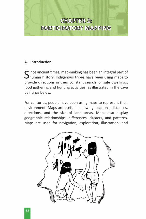
Since ancient times, map-making has been an integral part of human history. Indigenous tribes have been using maps to
provide directions in their constant search for safe dwellings, food gathering and hunting activities, as illustrated in the cave paintings below.
For centuries, people have been using maps to represent their environment. Maps are useful in showing locations, distances, directions, and the size of land areas. Maps also display geographic relationships, differences, clusters, and patterns. Maps are used for navigation, exploration, illustration, and
32

communication in the public and private sectors. Nearly every area of scientific inquiry uses maps, and therefore, maps are indispensable tools for many aspects of professional, academic, and community development work.
Simply put, a map is a representation of some part of the earth’s surface drawn on a flat surface (such as paper or on a computer monitor). It is defined as “any picture, drawing or group of objects that help people understand their place; maps are scale models of reality; a reduced and simplified model of reality containing geographic information; map contains spatial information such as patterns and structures; and an analysis tool to understand spatial relationships.”
From cave paintings to ancient maps of Babylon, Greece, and Asia, and towards the 21st century, computerized mapping such as the use of Geographic Information System (GIS) have evolved from the participatory rural appraisal where local communities have been using sketch maps as essential tools to define, explain, and plan their community development programs. Indeed, map-making has made a significant contribution to knowledge generation and the advancement of intellectual human development. Maps serve as a record for human history.
B. What is Participatory Mapping?
Participatory mapping is a set of approaches and techniques that combine the tools of modern cartography with traditional participatory methods to represent the spatial knowledge of local communities. It is based on the premise that local people are knowledgeable of their local surroundings and present conditions. Therefore, they must actively participate in community mapping activities. Participatory maps created by local communities represent the place in which they live, showing those elements they perceive as important, such as customary laws, land boundaries and traditional agricultural practices. It is important that local people control the use of
33
their maps containing detailed information about social, economic, and political trends, which they can use for community development.
C. Relevance of Participatory Mapping
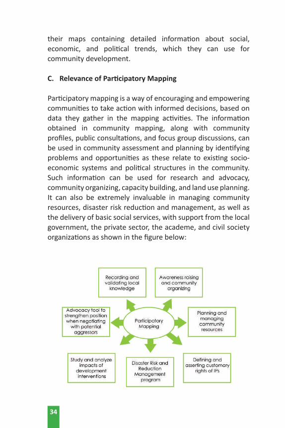
Participatory mapping is a way of encouraging and empowering communities to take action with informed decisions, based on data they gather in the mapping activities. The information obtained in community mapping, along with community profiles, public consultations, and focus group discussions, can be used in community assessment and planning by identifying problems and opportunities as these relate to existing socio-economic systems and political structures in the community. Such information can be used for research and advocacy, community organizing, capacity building, and land use planning. It can also be extremely invaluable in managing community resources, disaster risk reduction and management, as well as the delivery of basic social services, with support from the local government, the private sector, the academe, and civil society organizations as shown in the figure below:
34
For indigenous communities, participatory mapping is used for planning the sustainable management of their natural resources (PAFID, Tebtebba Foundation). It is a powerful tool for collective analysis and entry point for community organizing for local people to:
• be more critical about different types of development interventions in their locality;
• counter existing State policies that are discriminatory to indigenous peoples;
• gain full access and rights over productive and natural resources;
• document and manage their human and natural resources; • prepare for natural disasters and improve the status of their
general well-being; and,• support informed decision-making as basis for policy
advocacy towards community development.
Participatory mapping is an essential component for the development of the Ancestral Domain Sustainable Development and Protection Plan (ADSDPP), which can be used for land use planning, decision-making, and advocacy. It is a process where the indigenous peoples, including women and the youth, are active partners and not merely passive recipients of government programs or services. The indigenous peoples’ global partnership has identified five domains fundamental in indigenous peoples’ pursuit of self-determined development. But this can also be applied to small farmers and upland dwellers.
D. Different Types of Participatory Mapping
Participatory mapping emerged from participatory action research, which has been widely recognized worldwide. Map making is a way of bringing subordinated voices into a tangible and visible medium for negotiation and greater collaboration with the government and other stakeholders. In this regard, community mapping can be a tool for land rights advocacy and
35
the management of natural resources (IAPAD, 2017; Tebtebba Foundation; IFAD, 2011)
Basically, there are two major categories of community mapping, to wit:
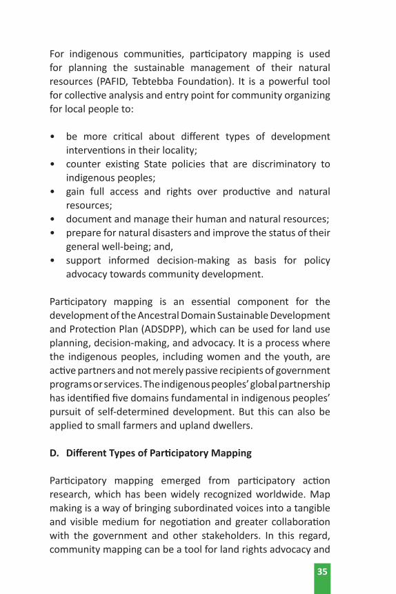
D1. Traditional Mapping Techniques
a) Sketch mapping - where community members draw maps on the ground or on paper based on their collective memories. The maps represent salient features of the land and other natural resources from a community’s perspective. The community members do not rely on exact measurements and do not use a consistent scale or geo-referencing. They do show the relational size and position of features. Commonly associated with Participatory Rural Appraisal and related initiatives.
b) Scale mapping - presents accurate geo-referenced data. A scaled map means that a distance measured anywhere on the map always represents (depending on the scale) the equivalent distance on the ground, e.g.
36
one centimeter on the map equals one kilometer on the ground. Scaled maps are often referred to as ‘base maps’ by mapping practitioners. This method is commonly
used where accurate and affordable scale maps are available. Local people are gathered and they are asked to discuss and draw a map based on the identified landmarks and spatial features: rivers, mountains, lakes, etc.
c) Eco-cultural Mapping - a method that collects indigenous peoples’ perception concerning forest areas,
grasslands, cultivated areas, water sources, sacred places, and natural resources within their domain. The community members are gathered and consulted about their agricultural practices, cultural norms, and traditional beliefs. The eco-cultural maps are drawn showing the community and geographic boundaries; the roads, water sources, cropland, pastureland, forested areas, etc., including major community infrastructures.
d) Participatory 3D Models - are created from the template of a topographic map where pieces of cardboard or rubber sheets are cut in the shape of the contour lines and pasted on top of each other. The model is then finished with wire nails, glue, plaster, and paint. Geographic features are depicted on the model using push pins (for points), colored string (for lines) and paint (for areas). A scaled and geo-referenced grid can be placed in the model to facilitate proper digitalization.
D2. Computerized Mapping Techniques
e) Geographic Information System (GIS) - is a collection of computer hardware, software, geographic data, and personnel assembled to capture, store, retrieve, update, manipulate, analyze, and display geo-referenced information.
37

f) Participatory GIS (PGIS) - is the fusion of participatory mapping with modern mapping techniques using GIS technology to capture data, manage, analyze, store, and present geo-referenced spatial information. These include spatial data management tools that can work with enabling tools such as imagery, Global Navigation Satellite System (GNSS).
PGIS technology used to be complicated and expensive but since the 1990s, the PGIS movement – spearheaded by NGOs and the academe – have tried to integrate local knowledge and qualitative data involving computer experts to transfer the technology locally as part of capacity building for community empowerment. PGIS has been used to influence policy makers. Practitioners place the control, access, and use of culturally-sensitive spatial data in the hands of the local people, thereby protecting traditional knowledge and wisdom from external exploitation.
g) Multimedia and Internet-based Mapping - can combine the usefulness of maps with other embedded digital media – such as video, images and audio – for information, education, and communication to the general public.
h) Google Earth - is an open source software that can be downloaded from the internet which has the satellite imagery of the Earth, is also being used by some local communities to map their land uses, as well as to locate their forests and other natural resources.
38
E. Basic Concepts of PGIS4 1. What is PGIS?
PGIS practice combines a range of geospatial information management tools and methods such as sketch maps, participatory 3D models (P3DM), aerial photographs, satellite imagery, GPS, and GIS to represent peoples’ spatial knowledge as virtual or physical or two- or three-dimensional maps. These are used as interactive vehicles for spatial learning, discussion, information exchange, analysis, decision making, and advocacy. PGIS implies making global information technology (GIT) available to disadvantaged groups in society in order to enhance their capacity to generate, manage, analyze, and communicate spatial information (Rambladi, 2017).
2. Brief History of PGIS
The participatory creation of maps began in the late 1980s, whereby development practitioners have been using Participatory Rural Appraisal (PRA) methods – such as sketch-mapping (Mascarenhas and Prem Jumar, 1991), rather than scale mapping – which is more complex and time-consuming. PRA practitioners preferred to elicit local knowledge and build on local dynamics to facilitate communication between insiders (e.g. villagers) and outsiders (e.g. researchers and government officials). This approach placed little emphasis on charting courses of action that would enable ordinary people to interact efficiently with policy-makers. The situation was further compounded by State control of aerial photography, satellite imagery and large-scale topographic maps, under the pretext of national security concerns.
39
4 The main source of this section: Introduction to PGIS Practice: Handbook for Trainees, Rambladi, G., June 2017 retrieved from www.iapad.org last 29 June 2017.

The state of affairs in mapping changed in the 1990s, with the diffusion of modern spatial information technologies (including GIS, global positioning system (GPS), remote-sensing image analysis software, and open access to spatial data and imagery via the Internet). With the steadily decreasing cost of computer hardware and the availability of user-friendly software, spatial data that were previously controlled by government institutions became progressively more accessible to, and mastered by, civil society organizations (CSOs) and community-based organizations, minority groups, and sectors of society traditionally disenfranchised and excluded from spatial decision-making processes (Fox, et. al., 2003).
The new environment facilitated the integration of geospatial information technologies and systems (GIT&S) into community-centered initiatives. Practitioners and researchers around the world were able to adopt a range of GIT&S to integrate multiple realities and diverse forms of information. Their objectives were to empower underprivileged groups, promote social learning, support two-way communication, and thereby broaden public participation across socio-economic contexts, locations, and sectors. This merging of community development with geospatial technologies to empower less-privileged communities has come to be known as Participatory GIS (PGIS) practice.
3. Significance of PGIS
PGIS practice implies making GIT&S available to less-favored groups in society to enhance their capacity to generate, manage, and use their own indigenous spatial knowledge (ISK) and externally-generated spatial information in contexts such as:
• self-determination (e.g. protecting ancestral land and resource rights and entitlements);
40
• management and amelioration of conflicts among local community groups and between communities and local authorities regarding access, use, control, and allocation of natural resources;
• collaborative research; • collaborative resource-use planning and management;• preservation of intangible cultural heritage and identity
building among indigenous people and rural communities;• good governance regarding transparency and consensual
spatial decision making; • raising awareness and assisting with education and social
learning for new generations;• community-based hazard management and risk reduction
(Gaillard and Maceda, 2009); and,• promotion of equity regarding ethnicity, culture, gender
and environmental justice.
More importantly, PGIS facilitates the building on ISK, such as:
• resource distribution: land cover and use, water sources, habitats;
• resource use, control and access:5 hunting, fishing, farming, grazing, mining, gathering, and harvesting from the wild;
• places of historic, cultural, and religious significance; ancestral grounds and sacred areas;
• indigenous names; cosmovisions, creation, and origin myths; and,
• hazard perception (e.g. landslides, floods, malaria).
ISK may complement “scientific knowledge” in cases related to resource location, water conservation, or livestock management. In such cases, ISK might be considered more relevant to the
5 Different maps on resource-use control and access can be produced for the same area by different groups in society. Of particular interest are the differentiated spatial perspectives of women, elderly people, youth and children (re: gender and age-related areas).
41

participatory process than the technology because it embodies generations of people’s practical knowledge. Some ISK is cognitively different from scientific knowledge (i.e. mental maps). Mental maps may incorporate overlapping or layered zones, blurred or multiple boundaries, and uncertain or restricted locations (McCall, 2004).
4. Prospects and Challenges for PGIS Application
PGIS practice currently faces a number of methodological and implementation issues. The sociopolitical context that provides the basis for PGIS applications often alters the interaction between the PGIS organization and local institutions as the established structures cooperate to alienate the new organizations. Further, community-based PGIS organizations in the South are resource-poor and often need to conform to pre-set data standards, software models and the views and dictates of local elites and external experts (Sieber, 2000). This leaves the PGIS organization vulnerable to being co-opted by public officials and agents that oppose its agenda.
As PGIS becomes a more widespread and accepted development practice, there is evidence that local elites and State agencies are attempting to control the practice as they have for decades with conventional development projects. PGIS projects in developing countries are often externally driven and geared towards data management instead of community empowerment. Some technocrats advocate for more robust technology transfer to ensure sustainability of PGIS projects.
When decisions are taken to implement geospatial technologies in community levels, important questions need to be addressed: Whose GIS is it? Whose questions are addressed? Who sets the agenda? What will happen when experts leave or when donor funding dries up? What is left with those who generated the data and shared their knowledge?
42
Even though PGIS applications have become widespread and computers and GIT&S are getting cheaper and more user-friendly, it is still difficult for community-based organizations to raise the required capital and recruit experts to implement, maintain, and sustain “high-tech” GIT&S. Also, the technology is believed to be limited in incorporating subjective values (which abound in the realm of ISK) into the quantitative analyses that occur in GIS applications (Heywood, et. al., 1995).
The nature and form of participation are also critical factors in determining the outcome of the community empowerment process. We know that public participation takes on different forms (Weidermann and Femers, 1993), and each has serious implications for community involvement and empowerment.
The issue of “scale” is of interest because different community issues and questions require a particular scale of analysis. Also important is the degree of spatial or locational “precision” (or accuracy) which is required or appropriate in participatory (i.e. local-level) spatial planning (Minang and Rambladi, 2004).
PGIS often involves integrating local and modern scientific knowledge for applications that can potentially empower local communities. Because this involves combining low and high technology, questions arise about accuracy tradeoffs, reliability, and acceptability.
Other critical aspects include: identifying avenues for institutionalizing PGIS practice within local planning and development agencies (if appropriate); mechanisms for ensuring protection of privacy and intellectual ownership of local knowledge; and promoting control of and access to data and information by those who generated such data. There is a need to evaluate the experiences (failures and successes), develop guidelines and strategies for good practice, and for the sound adoption of PGIS to meet the needs of different groups within the developing world.
43

5. PGIS in Practice
PGIS practice is geared towards community empowerment planning (Minang and Rambladi, 2004). through measured, demand-driven, user-friendly, and integrated applications of geospatial technologies. GIS-based maps and spatial analyses become major conduits in the process. A good PGIS practice is embedded into long-lasting spatial decision-making processes, is flexible, adapts to different socio-cultural and biophysical environments, depends on multi-disciplinary facilitation and skills, and builds essentially on visual language. The practice integrates several tools and methods, while often relying on combining “expert” skills with socially-differentiated local knowledge. It promotes interactive participation of stakeholders in generating and managing spatial information and uses information about specific landscapes to facilitate broad-based decision-making processes that support effective communication and community advocacy.
If appropriately used, the practice could exert profound impacts on community empowerment, innovation, and social change. More importantly, PGIS practice could protect traditional knowledge and wisdom from external exploitation by placing control of access and use of culturally sensitive spatial information in the hands of those who generated it.
Producing, georeferencing and visualizing ISK helps communities engage in peer-to-peer dialogue, promote their particular issues and concerns with higher-level authorities, and address economic forces.
Maps based on ISK are also used in adversarial contexts, such as in counter-mapping where indigenous communities adopt participatory mapping methodologies to regain a measure of control over ancestral lands and resources.
44

PGIS is a component of an integrated and multifaceted process that provides legitimacy for local knowledge, generates a great sense of confidence and pride among people who are involved in the process, and prepares them to deal with outsiders. The process fuels self-esteem and raises awareness about pressing issues in the community. Experiences from the Philippines have shown that exercises conducted at the community level in response to local needs have fostered community cohesion and identity building, as shown in Box 2. n
45
46
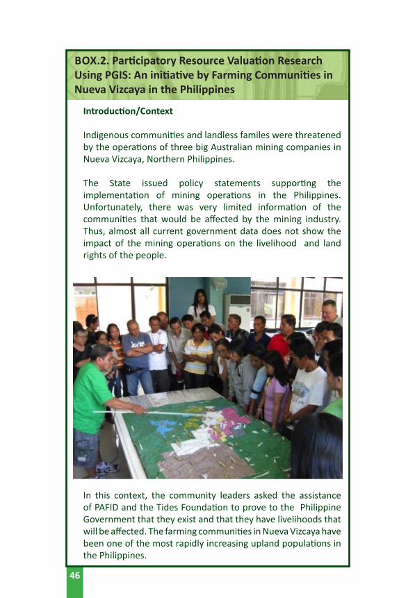
Introduction/Context Indigenous communities and landless familes were threatened
by the operations of three big Australian mining companies in Nueva Vizcaya, Northern Philippines.
The State issued policy statements supporting the implementation of mining operations in the Philippines. Unfortunately, there was very limited information of the communities that would be affected by the mining industry.Thus, almost all current government data does not show the impact of the mining operations on the livelihood and land rights of the people.
In this context, the community leaders asked the assistance of PAFID and the Tides Foundation to prove to the Philippine Government that they exist and that they have livelihoods that will be affected. The farming communities in Nueva Vizcaya have been one of the most rapidly increasing upland populations in the Philippines.
BOX.2. Participatory Resource Valuation Research Using PGIS: An initiative by Farming Communities in Nueva Vizcaya in the Philippines
47
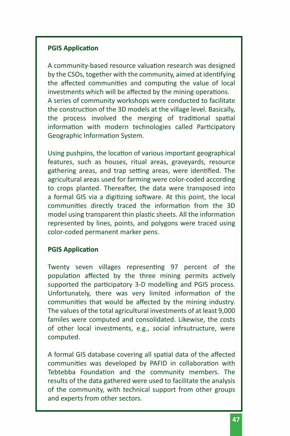
PGIS Application
A community-based resource valuation research was designed by the CSOs, together with the community, aimed at identifying the affected communities and computing the value of local investments which will be affected by the mining operations.
A series of community workshops were conducted to facilitate the construction of the 3D models at the village level. Basically, the process involved the merging of traditional spatial information with modern technologies called Participatory Geographic Information System.
Using pushpins, the location of various important geographical features, such as houses, ritual areas, graveyards, resource gathering areas, and trap setting areas, were identified. The agricultural areas used for farming were color-coded according to crops planted. Thereafter, the data were transposed into a formal GIS via a digitizing software. At this point, the local communities directly traced the information from the 3D model using transparent thin plastic sheets. All the information represented by lines, points, and polygons were traced using color-coded permanent marker pens.
PGIS Application
Twenty seven villages representing 97 percent of the population affected by the three mining permits actively
supported the participatory 3-D modelling and PGIS process. Unfortunately, there was very limited information of the communities that would be affected by the mining industry. The values of the total agricultural investments of at least 9,000 familes were computed and consolidated. Likewise, the costs of other local investments, e.g., social infrsutructure, were computed.
A formal GIS database covering all spatial data of the affected communities was developed by PAFID in collaboration with Tebtebba Foundation and the community members. The results of the data gathered were used to facilitate the analysis of the community, with technical support from other groups and experts from other sectors.
48
More than 270 community members were trained in basic spatial analysis and community mapping. The local municipal government adopted the results of the research to resolve internal boundary conflicts and used the data for land use planning. Hopefully, a resource valuation, combined with local peoples’ ideas with scientifically established techniques such as cost-and-return analysis and cash flow analysis, would be undertaken in the future.
Opportunities for Scaling-up
The positive experiences of PAFID field workers encouraged them to fully develop PGIS in various regions of the country to help marginalized groups such as small farmers and fishers. In fact, the spatial data of other sectors were generated and analyzed.
As a result, five 1:5000-scale 3D models were constructed by CSO workers with the active participation of local communities. The communities’ resource use patterns were drawn on the models by the local people using pushpins (for points), yarns (for lines), and paint (for polygons), which constitute the 3D modelling
The data became part of the publication entitled “Mining or Food?” which analyzed the adverse impacts of open pit mining operations on local communities in the Philippines; and the authors of the book recommended alternative courses of action to protect the enivironment and the people’s welfare. The book’s launching was supported by no less than Senator Aquilino Pimentel, the author of the Philippines’ Local Government Code. It was also presented in the British Parliament by a CSO leader of Tebtebba, with the support of MP Claire Short. Formal meetings and dialogues with mining companies were conducted in Manila by the team composed of the authors of the book. n
Source: PAFID

References:
Fox, J., Suryanata, K., Hershock, O., and Pramono, A. H. (2003). Mapping Power: Ironic Effects of Spatial Information Technology. Spatial Information Technology and Society: Ethics, Values and Practice Papers. Hawaii, USA: East-West Center.
Gaillard J.C. and Maceda E.A. (2009). Participatory Three-dimensional Mapping for Disaster Risk Reduction. PLA 60, 109-118, UK: IIED.
Heywood, I., Oliver, J., and Thompson, S. (1995). Building and Exploratory Multi-Criteria Modelling Environment for Spatial Decision Support. In Fisher, P. (ed). Innovations in GIS 2. London: Taylor and Francis.
Mascarenhas, J. and Prem Kumar, P. D. (1991). Participatory Mapping and Modelling Users’ Notes. PRA Notes 12, 9-20, IEED London. Retrieved from http://pubs.iied.org/pdfs/G01393.pdf.
McCall, M. (2004). Can Participatory GIS Strengthen Local-level Planning? Suggestions for Better Practice. 7th International Conference on GIS for Developing Countries (GISDECO 2004), 10-12 May 2004, Universiti Teknologi Malaysia, Johor Malaysia.
Minang P. and Rambladi G. (2004). Summary Proceedings of the Pre-conference Workshop on Participatory GIS. 7th International Conference on GIS and Developing Countries (GISDECO 2004), 10-12 May 2004, Universiti Teknologi Malaysia, Johor Malaysia.
Rambladi, G. (2005). Who Owns the Map Legend? URISA Journal, Vol. 17, No. 1.
Rambladi, G. (2017). Introduction to PGIS Practice: Handbook for Trainers. Retrieved from www.iapad.org.
Sieber, R. (2000). Conforming (to) the Opposition: The Social Construction of Geographical Information Systems in Social Movements. In International Journal of Geographic Information Science. Vol. 14, No. 8, pp. 775-793.
49

Weidermann, I. and Femers S. (1993). Public Participation in Waste Management Decision Making: and Analysis and Management of Conflicts. Journal of Hazardous Materials (33) 355-368.
50

CHAPTER 3:GEOGRAPHIC INFORMATION
SYSTEM TECHNOLOGY
49

CHAPTER 3:GEOGRAPHIC INFORMATION
SYSTEM TECHNOLOGY
A. Definition and Significance of GIS
Geographic information system (GIS) is a collection of computer hardware, software, geographic data, and
personnel assembled to capture, store, retrieve, update, manipulate, analyze, and display geographically referenced information. Basically, the information in the GIS would allow users to answer where things are or what is located at a given area.
Operationally, the GIS can link different data sets together. Hence land use planners, development practitioners, and local communities are using GIS because the system assists in visualizing, analyzing, and interpreting data collected to understand relationships, patterns, and trends affecting community life. GIS data is saved as shapefile (.shp) which can be shared with others using GIS software. GIS mapping enables better decision-making, improved communication, greater efficiency, and better record-keeping.
In recent years, there has been a growing movement towards securing the formal legal recognition of land rights for indigenous peoples, landless farmers, and local communities. The relationship between community land rights and human rights is important as land and natural resources are fundamental to the existence, livelihood, identity, and opportunities for rural communities.
52

Mapping of land and natural resources are valuable inputs to the development of frameworks for sustainable management of the lands, territories, and resources of the local people. Natural resources are essential to the growth of local economies because of the raw materials, food, medicine, and energy that these provide to various industries. Sadly, these resources are being depleted globally. In this light, GIS mapping provides a tool for indigenous peoples and other stakeholders to manage their natural resources, by producing a variety of maps related to land cover, vegetation, soil, geology, habitat, and resource use, among others. Natural resource information is critical in the development of sustainable resource management plans, and for the process of decision-making to ensure effective management practices are put in place.
The rural communities and indigenous peoples are estimated to hold as much as 65 percent of the world’s land area under traditional and customary systems, yet many governments formally recognize their rights to only a fraction of those lands. This is a major source of conflict, environmental degradation, and cultural extinction. Securing rights to land and resources enable people to exercise their traditional knowledge and management systems, manage external threats, and govern their territories as stewards towards sustainable human development.
B. Advantages of Using GIS
a) Find geographic features. Users can search a GIS database to find point, line, area, and surface features by their descriptions or measurements.
b) Measure geographic features. Users can measure lengths, widths, areas, and volumes, and compare sizes from one feature to another.
53

c) Characterize distributions. Users can group geographic features and define their distributions based on how much space they use, how close they are to each other, and where they are relative to other features.
d) Summarize geographic data. Users can calculate all sorts of statistics on their geographic features from the simplest descriptive statistics (for example, mean, median, and mode) to very complex spatial statistics.
e) Work with networks. Users can find routes based on time, distance, or other factors. For instance, scheduling bus routes to reach the maximum number of people and use population density information to locate stores near potential customers.
f) Compare map layers. Users can compare the locations of features from one map layer (or theme) to another. This powerful feature helps users to “overlay” the layers, and shows the relative location of features from one layer to another.
g) Perform surface analysis. Users can work on the many surfaces available in GIS and use mathematical methods (such as interpolation) to find missing values and perform other analyses.
Source: De Mers, M., GIS for Dummies
C. Components of GIS
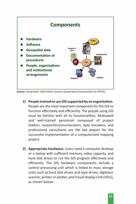
Basically, there are four interrelated components of GIS to function effectively and efficiently, as shown on the following page:
54
1) People trained to use GIS supported by an organization. People are the most important component for the GIS to function effectively and efficiently. The people using GIS must be familiar with all its functionalities. Motivated and well-trained personnel composed of project leaders, researchers/enumerators, data encoders, and professional consultants are the key players for the successful implementation of a computerized mapping project.
2) Appropriate hardware. Users need a computer desktop or a laptop with sufficient memory, video capacity, and hard disk drives to run the GIS program effectively and efficiently. The GIS hardware components include a control processing unit which is linked to mass storage units such as hard disk drives and tape drives, digitizer/scanner, printer or plotter, and Visual Display Unit (VDU), as shown below:
55
Source: Geographic Information Systems (powerpoint presentation by PAFID).
Components
n Hardwaren Softwaren Geospatial datan Documentation of proceduresn People, organizations and institutional arrangements

3) Appropriate software. GIS software ranges from simple “viewers” to “map-creation using software” that displays a small number of layers, to powerful applications that can handle and display enormous amounts of data. Some software can create and display GIS maps from a website, making them accessible to many users. Other types of software are non-GIS software programs yet it can use the data stored in them to create GIS maps. The software depends on the technical requirements of the GIS project, how much budget, and how important it is to the over-all functioning of the concerned agency.
Operationally, an effective GIS map-creation software should include:
a. The ability to enter and work with geographic and location information – street names, political boundaries, etc.
56
Source: GIS Components (M. Anji Reddy, 2008)

b. A database management system to organize and manage information. The GIS software package consists of four basic technical modules: (i) data input and verification;(ii) data storage and database management;(iii) data transformation and manipulation; and, (iv) data output and presentation.
c. A map creator easily viewed and simple to interpret and analyze.
d. A simple and usable graphical user interface (GUI) with various toolbars and controls.
4) Necessary Data. GIS software cannot create a map unless it has the information to do so. This comes from the five types of data that the software has to use, to wit:
Spatial data refers to information about the location, dimensions, shape, and the relationships among geographic features. In GIS, spatial data are technically classified as points, lines, areas, and raster grids.
Attribute data are information about who lives where, locations of different commercial and industrial establishments, land uses, demographics of the population (e.g. income, employment, education, crime rates), trends, and changes over time (e.g. tracing the conversion of farmlands to real estate developments for over 10 years).
Data Layers are the results of combining spatial and attribute data – essentially adding the attribute database to the spatial location.
Layer Types refer to the way spatial and attribute information are connected. There are three major layer types or models, to wit:
57

a. Vector - represents real-world features such as points, lines, and polygons.
• A point is represented in a computer database by x, y coordinates.
• A line is a sequence of x, y coordinates, whereby the end points are usually called nodes and the intermediate points are termed vertices.
• Polygons are represented by a closed series of lines such that the first point equals the last point of the loop. Points may be used to represent houses and lines as roads and rivers.
b. Raster - divides space into a regular array of rows and columns. A cell in this array or grid is sometimes called a pixel, which stands for a picture element and reveals the origin of this data model. In most raster systems, the attribute value at a given location is stored in the corresponding cell of the raster. The raster database of elevation is a long string of elevation numbers.
c. Topography - information on how geographic features are related to one another, and where they are in
Source: GIS Components (M. Anji Reddy, 2008)
58

relation to one another. Topology is the critical element that distinguishes a GIS from a graphics or automated cartography system. The GIS has the ability to employ spatial relationships and manipulate geographic relationships.
Essentially, the GIS links different data sets together. The data to be inputted, stored, and saved for a GIS database integrated system are acquired in various ways. Data are entered using a keyboard, by digitizing, or scanning. Data encoding and editing is called Data Stream as shown on the next page.
D. GIS Work Flow
GIS is a set of tools that allow for the processing of spatial and attribute data into information. To elaborate, data refers to raw, unorganized facts that need to be processed. Data can be something simple or randomly arranged. Unless organized, data is meaningless. When data is processed, organized, structured,
59

or presented in a logical manner and within a given context, it is called information as shown below:
Source: Conceptual view of GIS Data Stream (M. Anji Reddy, 2008)
60

Basically, there are five essential elements that a GIS must contain. These are data acquisition, pre-processing, data management, manipulation, and analysis; as well as product generation (M. Anji Reddy, 2008). These elements as interrelated as shown below:
Collection, inputting, and correction operations function with receiving data into the system that include manual digitizing, scanning, keyboard entry of attribute information, and online retrieval from other database systems. At this stage, a digital map is first constructed. The essential pre-processing includes (a) format conversion, (b) data reduction and generalization, (c) error detection and editing, (d) merging of points into lines, and lines into polygons, (e) edge matching and tiling, (f) rectification/registration, (g) interpolation, and (h) interpretation.
Database management provides consistent methods for data entry, updating, deletion, and retrieval. Modern database management systems isolate the users from the details of data
61
Functions
n Data capturen Data managementn Data query – database operationsn Analysis – perform spatial operationsn Visualization – displayn Outputs – reports
storage. A modern Database Management System (DBMS) is used to create the GIS database.
Storage and retrieval mechanisms include the control of physical storage of data in memory, disk, or other mechanisms for its retrieval to serve the other three components. This module includes the software structures used to organize spatial data into models of geographic reality. The development of new derived data layers, which may form the input to further analysis, is an important function of any GIS.
62

CHAPTER 4:PGIS PRACTICE IN THE PHILIPPINES
61

In this chapter, the practical application of Participatory Geographic Information System (PGIS) will be discussed
within the context of PAFID field experiences in the Philippines. For over two decades, PAFID is a CSO engaged in community development work, of which community mapping is an essential strategy to defend the land rights and assert the right to self-determination and autonomy of the indigenous communities in the Philippines.
PGIS is the spontaneous merger of participatory learning and action methods with geographic information technologies that combine a range of geospatial information management tools and methods to represent peoples’ spatial knowledge of the communities they live in (Zingapan, 2017). Essentially, PGIS is a fusion of participatory mapping technique and GIS technology for the production of evidenced based digital maps, useful for land rights advocacy and for sustainable planning and management of natural resources.
A. PGIS Components and Requirements
Basically, PGIS has four interrelated components to function effectively and efficiently. Based on PAFID field experience, it is imperative to conduct social preparation and fulfill the technical requirements of the project prior to PGIS mapping, as shown on the following page.
CHAPTER 4:PGIS PRACTICE IN THE PHILIPPINES
64
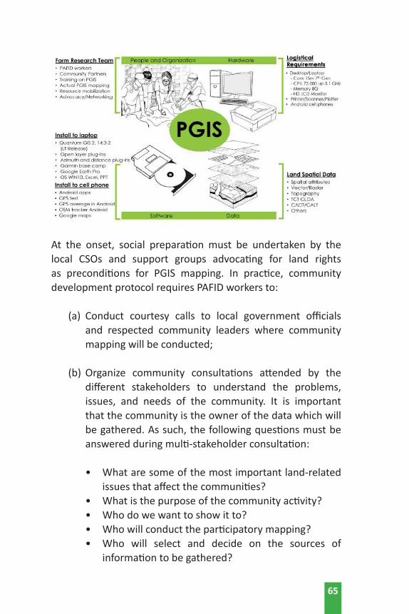
At the onset, social preparation must be undertaken by the local CSOs and support groups advocating for land rights as preconditions for PGIS mapping. In practice, community development protocol requires PAFID workers to:
(a) Conduct courtesy calls to local government officials and respected community leaders where community mapping will be conducted;
(b) Organize community consultations attended by the different stakeholders to understand the problems, issues, and needs of the community. It is important that the community is the owner of the data which will be gathered. As such, the following questions must be answered during multi-stakeholder consultation:
• What are some of the most important land-related issues that affect the communities?
• What is the purpose of the community activity?• Who do we want to show it to?• Who will conduct the participatory mapping?• Who will select and decide on the sources of
information to be gathered?
65

• Who controls and uses the results of the mapping activities?
• Where do we conduct the community mapping? • What are the spatial extents and limits of the
participatory mapping exercise? (Source: PAFID)
(c) Community profiling and interviewing to get primary and secondary data for the project study;
(d) Formation of a local research team composed of CSO workers and representatives of the basic sectors, such as IPs and other stakeholders, who are willing to attend the Basic Orientation and Skills Training on PGIS; and,
(e) Community planning and resource mobilization to provide administrative and logistical support to fulfill the technical requirements of the project, such as securing hardware and software requirements (i.e., desktop computers, laptops, personal cellphones, printers, scanners, and plotter, among others).
B. PGIS Operational Framework
Basically, PGIS mapping is anchored on the need to develop a National Digital Land Use Database in the Philippines that will address critical gaps in generating accurate maps useful for land rights advocacy, and for sustainable use and management of natural resources.
PGIS requires community consultations participated in by different stakeholders to identify the problems, issues, and needs of the community. Thereafter, recruitment and training of local researchers on PGIS will commence, followed by community planning and logistical preparation to comply with the technical requirements of the PGIS process.
66

The local research team will conduct community profiling, interviewing, and actual field survey to capture GPS/GNSS raw data using GPS Garmin receiver, e-tablets or mobile phones. Once all the spatial data have been collected, computerized mapping using a desktop or a laptop will ensue to input or download the GPS/GNSS data to a computer or USB.
In practice, the PGIS along with Quantum GIS (QGIS) software will be used for data storage, retrieval, manipulation, data modeling, and analysis for digital map production useful for advocacy and for other purposes, to improve the situation of IPs and disadvantaged groups as shown below.
Essentially, PGIS is a system used for data collection, data management, processing, and analysis of spatial data to develop accurate digital maps for the empowerment of grassroots communities. Users of this PGIS manual need to understand
67
Source: PGIS Training for ILC Partners in the Philippines jointly organized by PAFID and ANGOC (April 2017).
the definitions and interrelationships of the following technical terms:
Data Capture means that data are obtained and gathered from their source, either from a document (i.e. questionnaire) or from an input device (i.e. GPS Garmin receiver, e-tablets and mobile phones, heat sensor, or scanner). Two of its important activities are:
(a) Verification - the process of checking that the data have been correctly entered into the computer; and
(b) Validation - which takes place before the processing stage and is used to double-check the accuracy of data through double entry and proofreading.
Data Input refers to the creation of digital spatial data. It is the process of feeding data into a desktop computer or laptop for downloading, saving, and data processing.
Database Management refers to unique issues in the maintenance of spatial data, such as checking for errors or level of accuracy; storing data; retrieving data; and metadata. Data management is one of the key issues in determining the usability of spatial data. The installation and application of QGIS software has been used by PAFID for this purpose.
Data Processing is the restructuring of data to increase their usefulness and add values for a particular purpose. It involves calculation, analysis, comparison, data manipulation, sorting, searching, and transformation of data. Some of its important functions are summarizing, computing averages, graphing, creating charts, and visualizing data.
Data Analysis is answering questions that may not be explicitly stated in the data.
68

Data Output refers to the method used to visually display analysis performed using QGIS. Data Output can take many forms such as text, sound, tables of data, graphs, commands, etc. Depending on the form of output required, the data can be transmitted by a range of devices for presentation:
Digital Map Production is a graphic representation or scale model of spatial concepts. It is a means for conveying geographic information;
Charts are pie charts, histograms (bar charts), line charts, and pictures;
Directions show the users how to get from one place to another; and,
3D diagrams and movies for power point presentations intended for advocacy and land use planning. n
69

Introduction/Context
Indigenous peoples in the Philippines belong to the poorest of the poor, having been deprived for the longest time of legal recognition of their territories. Yet, there is a legal framework in place that recognizes the rights of indigenous peoples.
Passed in 1997, Republic Act 8371 or the Indigenous Peoples
Rights Act (IPRA) addresses four substantive rights of indigenous people/communities: (i) the right to ancestral domains and lands, (ii) the right to self-governance and empowerment; (iii) the right to cultural integrity; and, (iv) social justice and human rights. The law defines ancestral domains to cover “forests, pastures, residential and agricultural lands, hunting grounds, worship and burial areas, including lands no longer occupied exclusively by indigenous cultural communities, but to which they had traditional access.”
Under the principle of self-determination, IPRA allows indigenous communities to document and delineate their own ancestral domain claims and to formulate their own ancestral domain sustainable development and management plans (ADSDPPs) based on their indigenous knowledge systems and practices.
In this context, many indigenous communities in the Caraga region have been reclaiming and negotiating the legal recognition of their ancestral domains. Yet, the boundaries of their domains had not been properly identified and mapped, causing extreme frustration within the communities whose claims were often questioned as to their legitimacy. Without perimeter maps and community plans, there were other competing claimants over their ancestral lands that include mining, logging, and plantation companies.
Since 1995, the Philippine Association for Intercultural Development (PAFID) has been adopting the use of participatory
BOX 3. Reclaiming Ancestral Domains in the Philippines thru PGIS
70

three-dimensional mapping (P3DM) as a tool for community development in the Philippines as it relates to indigenous peoples’ land rights claim, and to facilitate ancestral domain management planning (ADMP).
PGIS: Marrying Traditional Knowledge and Technical Processes
A 3-D map is a physical model of a place. It uses an appropriate scale that shows the rivers, mountains, and valleys, as well as the location of residential, and cultivated areas, and the resources from which communities derive their livelihoods. It also records indigenous knowledge, beliefs, and practices (i.e., sacred areas, burial sites, etc.), and all those features that have social, cultural, and spiritual significance to the local people.
The mapping process relies heavily on the participation of indigenous communities in delineating their own domains based on physical and cultural markers. This establishes the basis for their filing of ancestral domain claims.
With P3DM, the local communities are guided by PAFID fieldworkers to construct a relief model of their ancestral domain; by combining local knowledge with the use of global positioning system/geographic information system (GPS/GIS) technology for data capturing accurate and easily understandable spatial information such as area, location, distance, and land uses; thus providing critical technical inputs in formulating its ancestral domain management plans.
Empowering communities for claim making and domain planning involves several related activities:
• Discussion of IP community situation. Fora and community meetings are first organized to discuss the general situation of indigenous peoples and the salient features of the IPRA - e.g., socio-economic and tenurial rights of IP communities; community rights and obligations to protect, utilize, and develop their ancestral domains. Some larger fora may be attended by both tribal leaders and local government officials and may involve up to 300 people.
71
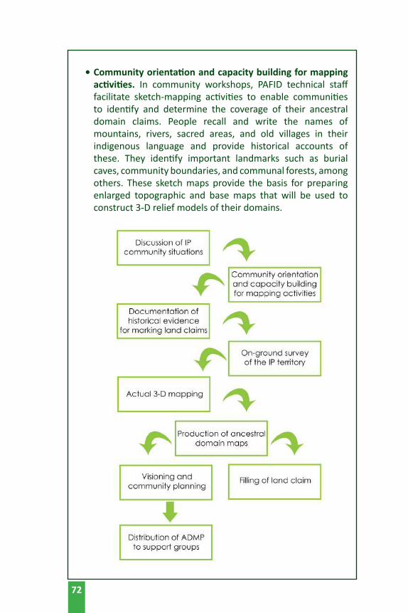
• Community orientation and capacity building for mapping activities. In community workshops, PAFID technical staff facilitate sketch-mapping activities to enable communities to identify and determine the coverage of their ancestral domain claims. People recall and write the names of mountains, rivers, sacred areas, and old villages in their indigenous language and provide historical accounts of these. They identify important landmarks such as burial caves, community boundaries, and communal forests, among others. These sketch maps provide the basis for preparing enlarged topographic and base maps that will be used to construct 3-D relief models of their domains.
72
In preparation for the conduct of on-ground perimeter surveys, PAFID technical staff also conduct a series of community train-ings on the use of GPS instruments and other survey equip-ment. Resource persons often include tribal leaders from oth-er communities who have been previously trained on GPS and have already done perimeter surveys of their own ancestral
domains. Capacity building is also ingrained in actual 3-D mapping and
community planning. • Documentation of historical evidence for making land
claims. Throughout the mapping process, PAFID staff work closely with the community in gathering evidence to support their ancestral domain claims. These include extensive gathering of documentary and physical evidence, recording of historical and oral accounts, writing affidavits and testimonies of elders, and genealogical profiling. These are compiled into “claim-books,” the set of documents submitted to the National Commission on Indigenous Peoples (NCIP) containing the mandatory requirements needed for IPs to support their claim to their land.
Experience has shown the many difficulties usually encountered during field research. Official statistics regarding tribal communities are neither available nor credible. Often, key informants such as tribal elders are not available or may have moved elsewhere. Local customs may require baylans or spiritual masters to conduct certain rituals before they are able to mention names of persons and sacred places or to divulge indigenous systems and practices. Some communities face internal difficulties because of boundary disputes or leadership conflicts. Moreover, in areas such as eastern Mindanao, there are peace and order problems due to the presence of rebel groups and military operations in indigenous community areas.
• Community on-ground survey of the territory. Assisted by a PAFID technical team, GPS trained members of the community conduct an on-ground perimeter survey to
73
delineate the ancestral domain. They take a perimeter walk to mark off the natural boundary lines and cultural markers of the domain. They also take point positions of important geographical features inside the domain. These include the location of barangays, sitios, schools, health centers, markets, bridges, concrete and rough roads, and rivers and streams.
All the data gathered are overlaid on a topographic map. This is then used as the base map for determining the extent of the domain.
• Actual 3-D mapping. Using the base map, community members then construct a relief or 3-D map model at the appropriate scale. The youth, women, elders, and leaders are actively engaged in the construction, identification of landmarks, and recollection of historical accounts of old villages, sacred mountains, and rivers. Sketch maps that were previously drawn at the start of the process are used as additional reference for spatial information.
Physical materials used for the actual construction of the 3-D map may vary – from resin to rolls of rubber sheets. The physical work involves preparing the base frame; numbering contour lines on the base map; tracing, cutting, and layering rubber sheets; and coating the model with epoxy and painting it white. Once dried, the community then traces and locates geographical markers and land uses on the map (including sacred sites, forests, indigenous settlements, transient settlers, mountains and rivers, traditional farms, etc.).
Through this process, the 3-D map is able to combine accurate spatial information with community-relevant data. Once finished, the 3-D map is treated as an accomplishment of the whole local community.
The 3-D map serves as a user-friendly technical tool in the effort of indigenous communities to identify the exact extent of their domains, and to help resolve boundary disputes and other long-standing land problems. Communities also use these maps to dialogue with government and corporations and discuss issues related to the entry or continued operation
74

of mining, logging, and plantation companies within their domains.
• Production of ancestral domain maps. Other maps are then produced through data generated from the 3-D map to represent the various land uses and other technical information on hydrology, slope incidence, and tenurial patterns, or to show settlement areas and road networks. Hazard and risk maps, particularly those showing flood- and landslide-prone areas, may also be produced as part of the map series that will be used during the formulation of the ADMP.
• Visioning and community planning. The participatory way in which mapping activities are conducted enables the people to see, understand, and better appreciate the land-use situation in their domain. This sets the stage for the community to formulate its domain management plans and priorities, as well as community rules and regulations, based on indigenous resource management systems and practices. The 3-D map serves as the community’s guide in formulating its own ADMP.
75

76
• Distribution of ADMP to support groups. The community may choose to provide a copy of the ADMP to NCIP and LGUs for adoption and integration into municipal development plans and comprehensive land use plans. The community may also opt to look for other sources of funds to implement their ADMP.
• Filing of land claims. PAFID assists the community in packaging the documents and maps into a claim folder. The community then submits this claim folder, together with their official letter to NCIP, in their application for ancestral domain claims. n
Source: De Vera, D. et.al., of PAFID, Moving up Innovations to Scale, IFAD (September 2014)

77
OTHER REFERENCES

References:
Biano, Helen M., M., Balawag, G.Balawag., F., Daguitan, E., Batang-ay. J., Guillao, J. (2015). Community-based monitoring and information systems (CBMIS) for community trainers and organizers. Baguio City: Tebtebba Foundation. Retrieved from https://www.google.com.ph/#q=Community-based+monitoring+and+information+systems+(cbmis)+for+community+trainers+and+organizers
Colley, J.D. First interactive global map of indigenous and community territories will help secure land rights worldwide and boost forest conservation efforts, Retrieved from https://www.culturalsurvival.org/publications/cultural-survival-quarterly/community-based-mapping-southeast-asia
DeMers, M. (2009). GIS for dummies cheat sheet. Retrieved from http://www.dummies.com/education/science/gis-for-dummies-cheat-sheet/
Environmental Mainstreaming Initiative (2009). Participatory geographical information system, Profiles of Approaches. Tools and Tactics for Environmental Mainstreaming. London: International Institute for Environment and Development (IIED). Retrieved from https://www.google.com.ph/search?q=GIS+introduction+and+overview&rlz=1C1NHXL_enPH721PH721&oq=GIS+introduction+and+overview&aqs=chrome..69i57.1668j0j4&sourceid=chrome&ie=UTF-8#q=Participatory+geographical+information+system,+Profiles+of+Approaches+IIED
Forrester, J., Cinderby, S. (n.d.). A guide to using community mapping and participatory GIS. Stockholm: Stockholm Environment Institute, Environment Department. Retrieved from http://www.tweedforum.org/research/borderlands_community_mapping_guide_.pdf
Gessa, S.D., Poole, P., Bending, T. (2008). Participatory mapping as a tool for empowerment: experiences and lessons learned from the ILC networks, Knowledge for Change, 1-27, International Land Coalition (ILC), Rome, Italy. Retrieved from http://www.
78
iapad.org/wp-content/uploads/2015/07/08_ilc_participatory_mapping_low.pdf
Haithcoat, T., (n.d.). GIS introduction and overview. Columbia: University of Missouri, Department of Geography. Retrieved from http://msdis.missouri.edu/resources/intro_to_gis/pdf/GIS_intro_over.pdf
International Fund for Agricultural Development (IFAD). (2009). Good practices in participatory mapping. Retrieved from http://www.ifad.org/pub
Melcher, J., Groop, R., Keuth, J., Rozdilsky, J. (1999). Several forms of community mapping, Best Practice Briefs 3 (1998-1999). US: Michigan State University. Retrieved from http://outreach.msu.edu/bpbriefs/issues/brief3.pdf
Reddy, A.M. (2008). Textbook of remote sensing and geographic information system, Third Edition. India: Jawaharlal Nehru Technological University. Retrieved from http://www.gisresources.com/wp-content/uploads/2013/09/anji-reddy_GIS.pdf
United Nations (2000). Handbook on geographic information systems and digital mapping, Studies in Methods, Series (79). Studies in Methods, Series 79. New York: United Nations Publications. Retrieved from https://unstats.un.org/unsd/publication/SeriesF/SeriesF_79E.pdf
Watry, G. (2007). Introduction to Quantum GIS (Titan) version 0.8.0, 1, COAPS. US: Florida State University. Retrieved from http://www.gisresources.com/wp-content/uploads/2013/09/Introduction_to_Quantum_GIS_0_8_0.pdf
Zingapan, K., Shortland, S. (2015). Training manual on GPS mapping: tip sheet for Garmin Oregon 650 GPS and GIS Cloud, Asia Indigenous People Pact (AIPP), 1-18 Chiang Mai: AIPP Printing Press, Co., Ltd.
79
Power Point Presentations of PAFID
De Vera, D. (2017). 3PDM Planning and Advocacy. Quezon City: PAFID.
De Vera, D. (2017). Mapping and Social Justice. Quezon City: PAFID.
De Vera, D. (2017). National Database. Quezon City: PAFID.
De Vera, D. (2017). Participatory Research Valuation using GIS. Quezon City: PAFID. Zingapan, K. (2017) GNSS/GPS. Quezon City: PAFID.
Zingapan, K. (2017). Garmin GPS Map64s. Quezon City: PAFID.
Zingapan, K. (2017). GIS. Quezon City: PAFID.
Zingapan, K. (2017). GNSS Apps on Android. Quezon City: PAFID.
Zingapan, K. (2017). Map Elements. Quezon City: PAFID.
Zingapan, K. (2017). QGIS. Quezon City: PAFID.
Zingapan, K. (2017). Rasters. Quezon City: PAFID.
Zingapan, K. (2017). Reference Systems. Quezon City: PAFID.
80

As the overseas development agency of the Catholic Church in Germany, MISEREOR works in partnership with all people of goodwill to promote development, fight worldwide poverty, liberate people from injustice, exercise solidarity with the poor and persecuted, and help create “One World.”
MisereorMozartstrasse 9
52064 Aachen GermanyTel: +49/241/4420
The National Engagement Strategy (NES) was initiated as a response to the need for the International Land Coalition (ILC) to engage in selected countries in a focused, coherent, and coordinated manner that emerged from past lessons. ILC
has been a development partner of Philippine CSOs engaged in promoting asset reform and pointing out the deficiencies of policies in current land and resource rights.
ILC NES in the Philippines synergizes the efforts of the members with other stakeholders such as government and international organisations in building on previous efforts to increase and strengthen access to and control of land and other natural resources in rural sectors.
Website: ilc-nes.ph
Land Watch Asia (LWA) is a regional campaign to ensure that access to land, agrarian reform and sustainable development for the rural poor are addressed in national and regional development agenda. The campaign involves civil society organizations in seven (7) countries— Bangladesh, Cambodia, India, Indonesia, Nepal, Pakistan, and the
Philippines. LWA aims to take stock of significant changes in the policy and legal environments; undertake strategic national and regional advocacy activities on access to land; jointly develop approaches and tools; and, encourage the sharing of experiences on coalition-building and actions on land rights issues.
Asian NGO Coalition for Agrarian Reform and Rural Development 33 Mapagsangguni Street, Sikatuna Village,
Diliman, 1101 Quezon City, Philippines P.O. Box 3107, QCCPO 1101, Quezon City, Philippines
Tel.: +63-2 3510581 | Fax: +63-2 3510011 E-mail: [email protected] | URL: www.angoc.org
The International Land Coalition (ILC) is a global alliance of civil society and intergovernmental organizations working together to put people at the center of land governance. The shared goal of ILC’s members is to realize land governance for and with people at country level, respond to the needs and protect the rights of women, men and communities who live on and from the land.
International Land CoalitionVia Paolo di Dono 44, 00142 Rome, Italy
Tel: +390654592445Email: [email protected]
The Regional Coordination Unit of ILC is hosted by KPA and can be reached at: KPA, Komplek Liga Mas, Jl. Pancoran Indah I
No. 1 Block E3 Pancoran, South Jakarta, 12760 Indonesia Tel: +62217984540
Email: [email protected]
La
nd Watch Asia

This publication, A Resource Book on Participatory Geographic Information System (PGIS) for Land Rights Advocates, aims to equip land rights advocates, development practitioners and smallhoder farmers and indigenous peoples communities with the necessary knowledge, attitude, and skills on Community Mapping and Participatory Geographic Information System (PGIS). It focuses on data collection, database management, data processing, and analysis for the production of digital maps useful in advancing the land rights agenda of rural communities, particularly indigenous communities and smallholder farmers in Southeast Asia.
This publication is designed to impart the key concepts of community mapping and the basics of participatory GIS (PGIS), with the view that the application of PGIS technology contributes to (1) securing legal recognition of the indigenous communities over their traditional territories and resources, and (2) for smallholder farmers and landless rural poor to defend their rights to land and the sustainable use of natural resources.