
A Publication of the Partnership for the National Trails
16
Pathways Across A Publication of the Partnership for the National Trails System Spring 2013 America
Transcript of A Publication of the Partnership for the National Trails

PathwaysAcross
A Publication of the Partnership for the National Trails System
Spring 2013America

11
Pathways Across AmericaPathways Across America is the only national publication devoted to the news and issues of America’s national scenic and historic trails. It is published by the Partnership for the National Trails System under cooperative agreements with:
Department of Agriculture: USDA Forest Service
Department of the Interior: National Park Service, Bureau of Land Management, U.S. Fish and Wildlife Service
Department of Transportation: Federal Highway Administration
Administration:Gary Werner [email protected] 608-249-7870Editing and Design: Julia Glad [email protected] for the National Trails System222 S. Hamilton Street - Ste. 13 Madison, WI 53703
For information about the Partnership for the National Trails System or to learn how to contact any of our partner groups visit the PNTS web site at: www.pnts.org.Unless otherwise indicated, all material in Pathways Across America is public domain. All views expressed herein perspectives of individuals working on behalf of the National Trails System and do not necessarily represent the viewpoint of the Federal Agencies.
Pathways serves as a communication link for the major partners of the following national trails:Ala Kahakai National Historic TrailAppalachian National Scenic TrailArizona National Scenic TrailCalifornia National Historic TrailCaptain John Smith Chesapeake National Historic TrailContinental Divide National Scenic TrailEl Camino Real de Tierra Adentro National Historic TrailEl Camino Real de los Tejas National Historic TrailFlorida National Scenic TrailIce Age National Scenic TrailIditarod National Historic TrailJuan Bautista de Anza National Historic TrailLewis and Clark National Historic TrailMormon Pioneer National Historic TrailNatchez Trace National Scenic TrailNew England National Scenic TrailNez Perce (Nee-Me-Poo) National Historic TrailNorth Country National Scenic TrailOld Spanish National Historic TrailOregon National Historic TrailOvermountain Victory National Historic TrailPony Express National Historic TrailPacific Crest National Scenic TrailPacific Northwest National Scenic TrailPotomac Heritage National Scenic TrailSanta Fe National Historic TrailSelma to Montgomery National Historic TrailStar-Spangled Banner National Historic TrailTrail of Tears National Historic TrailWashington-Rochambeau Revolutionary Route National Historic Trail1
The National Trails Pathways Nationwide for
National Trails System?The National Trail System includes 3 main types of national trails: Scenic Trails, Historic Trails, and Recreation Trails.
Categories of National Trails: National Scenic & Historic Trails
NSTs and NHTs are designated by Congress (see specific descriptions below). The Partnership for the National Trails System (see left) is the nonprofit dedicated to facilitating stewardship of the Scenic and Historic Trails as a group.
National Recreation TrailsOffer local and regional trail experiences in thousands of locations around the country. The nonprofit American Trails encourages the stewardship of the National Recreation Trails (NRTs). NRTs are designated by the Secretary of Interior or the Secretary of Agriculture.
What is the
Ala Kahakai NHTCalifornia NHTCaptain John Smith Chesapeake NHTEl Camino Real de Tierra Adentro NHTEl Camino Real de los Tejas NHTIditarod NHTJuan Bautista de Anza NHTLewis and Clark NHTMormon Pioneer NHTNez Perce (Nee-Me-Poo) NHTOld Spanish NHTOregon NHTOvermountain Victory NHTPony Express NHTSanta Fe NHTSelma to Montgomery NHTStar-Spangled Banner NHTTrail of Tears NHTWashington-Rochambeau Revolutionary Route NHT
19 National Historic Trails National Historic Trails may be foot or horse paths, travel routes, roadways, or a combination of both designated as a route retracing a part of American history. Many National Historic Trails have interpretive centers and regular events to immerse you in the past. While historic trails may run through urban and suburban settings, they boast wilderness and hiking opportunities as beautiful and diverse as the National Scenic Trails.
Heritage ∙ History ∙ Hiking ∙ Culture ∙ Reenactments
Building Community...

TABLE OF CONTENTSThe 2012 “Gold Sheet” of Volunteer Hours and Contributions ...3
2013 National Scenic and Historic Trails Conference ...................4
Scenic History, Historic Hikes.........................................................5
Historic Places Along the Ice Age NST...........................................5
Favorite Hikes along the Santa Fe NHT.........................................6
National Trails System Collaborative Landscape Planning Initiative 2014 and 2015 Proposals.......................................7
Arizona Trail Association Launches Seeds of Stewardship Program to Engage Youth...................................................9
New Segment of North Country NST through Tamarac NWR Officially Opens on National Trails Day...............................11
Steve Elkinton Receives Lifetime Achievement Award at
International Trails Symposium.................... ....................12
Juan Bautista de Anza NHT Launches New Website; Publishes Enhanced Trail Map............................................13
Re-enactments Bring to Life the History of the Natchez Trace Parkway.......................................................14
National Trails System Calendar of Events..................................15
2
The National Trails Pathways Nationwide for
System... Discovery, Learning, & Understanding
Keeping History Alive... Preserving Biodiversity
THE PATHWAYS COVERThe Spring 2012 Pathways Across America cover depicts a blend of national scenic and historic trail viewscapes and activities. From top left to bottom right: camus flowers along the Nez Perce NHT, photos courtesy of the U.S. Forest Service; Wagons Ho event at Bent’s Old Fort along the Santa Fe NHT; photo by Ruth Friesen of the Santa Fe Trail Association; azalea flowers along the Appalachian NST, photo courtesy of the Appalachian Trail Conservancy; bicentennial commemoration march of Andrew Jackson along the Natchez Trail Parkway, courtesy of the Natchez Trace Parkway Association; yellow flowers along the North Country NST, courtesy of the North Country Trail Association; and Tamarac National Wildlife Refuge segment dedication of the North Country NST, courtesy of the U.S. Fish & Wildlife Service.
Inside cover photos from left to right: A youth-oriented Leave No Trace Workshop at Florida Trail Days, photo courtesy of the Florida Trail Association; Handcart treks along the Mormon Pioneer NHT, courtesy of the Mormon Historic Trails Association; and the California Trail, courtesy of the National Park Service.
Facilitating Public-Private Partnerships for preservation of history, natural environments, and human health through outdoor recreation.
Strengthening Communities through heritage and ecotourism, public involvement, and community collaboration.
EnhancingAccess to natural areas and historic treasures through innovative interpretation and community outreach efforts.
Appalachian NSTArizona NSTContinental Divide NSTFlorida NSTIce Age NSTNatchez Trace NSTNew England NSTNorth Country NSTPacific Crest NSTPacific Northwest NSTPotomac Heritage NST
11 National Scenic Trails
Hiking ∙ Backpacking ∙ Photography ∙ Wilderness ∙ Wildlife
The National Scenic Trails represent some of the most magnificent long-distance hiking trails anywhere in the world. Virtually every major ecosystem in the US is traversed by a National Scenic Trail, from deserts, temperate rainforests, tundra, mountains, prairies, temperate deciduous forests, wetlands, and rivers. The National Scenic Trails offer natural corridors for wildlife preservation and unspoiled viewscapes, and they create fitness and outdoor leadership opportunities for all ages.

3
CONTRIBUTIONS MADE IN 2012
TO SUPPORT THE NATIONAL TRAILS SYSTEM BY NATIONAL SCENIC AND HISTORIC TRAIL ORGANIZATIONS
ORGANIZATION VOLUNTEER HOURS
ESTIMATED VALUE OF VOLUNTEER LABOR
FINANCIAL CONTRIBUTIONS
Ala Kahakai Trail Association & E Mau Na Ala Hele 10,090** $223,393 $8,000 Appalachian Trail Conservancy 239,109 $5,293,873 $4,236,000
Arizona Trail Association 11,234 $248,720 $113,415 Camino Real Trail Association 5,050*
$111,807* $4,000*
Camino Real de los Tejas NHT Association 2,773 $61,394 $29,771 Continental Divide Trail Partner Organizations 26,952 $596,717 - Florida Trail Association 43,070 $953,569
$173,803
Ice Age Trail Alliance 69,896 $1,547,497 $521,014
Iditarod Historic Trail Alliance 15,780 $349,369 $24,170 Anza Trail Coalition of Arizona, Anza Trail Foundation, and other trail partners 22,295 $493,611 $26,170*
Lewis & Clark Trail Heritage Foundation 133,381 $2,953,055 - Lewis and Clark Trust, Inc. 6,000 $132,840 $13,000 Mormon Trails Association and Mormon Trail Partners** $50,975** $1,128,587** $56,000** Natchez Trace Parkway Foundation 1,610 $35,645 $16,379 National Pony Express Association 35,000** $774,900 $11,280 New England National Scenic Trail (CFPA + AMC) 7,851 $173,821 $47,000 Nez Perce Trail Foundation 14,337 $317,421 $4,240 North Country Trail Association 73,274 $1,622,286 $352,204 Old Spanish Trail Association 19,450 $430,623 $62,649 Oregon-California Trails Association 92,046 $2,037,898 $477,453 Overmountain Victory Trail Association 11,915** $263,798** $34,000** Pacific Crest Trail Association 92,418 $2,046,135 $939,540 Pacific Northwest Trail Association 34,533 $764,560 $18,800 Potomac Heritage Trail Association 14,000* $309,960* $825* Santa Fe Trail Association 61,640 $1,364,710 $360,949 Trail of Tears Association 73,846 $1,634,950 $23,950
Washington-Rochambeau Revolutionary Route NHT Association (W3R-US) 16,850* $373,059* $11,165
TOTALS 1,185,375
$26,244,198
$7,565,777
* 2011 data **estimate Note: value of Volunteer Hours calculated using the national 2012 value of volunteer time of $22.14 published by the Independent Sector.
CONTRIBUTIONS MADE IN 2012 TO SUPPORT THE NATIONAL TRAILS SYSTEMBY NATIONAL SCENIC AND HISTORIC TRAIL ORGANIZATIONS
About the “GOLD SHEET” of Volunteer Hours and ContributionsThe trail stewardship organization partners of the national scenic and historic trails provide the critical private support of the unique public-private partnerships that have characterized the National Trails System since its inception. Together, these partners contribute over a million volunteer hours each year, organizing outreach events, building and maintaining trail, working to protect ecosystems and viewsheds, and interpreting the trails. Many of these invaluable volunteer hours are performed in collaboration with Federal projects; volunteers provide critical assistance for many of the functions of the land management agencies. These hours do not represent all of the volunteer hours performed on behalf of the National Trails System, only those recorded by the official stewardship organizations affiliated with each trail. Many other organizations have invested considerable time, energy, and funds into the national scenic and historic trails.
The strong volunteer involvement on the National Trails System leverages Federal, State, and local investment in the trails. While the process of recording volunteer hours can be an arduous and complicated one, particularly given the vast range of activities of trail volunteers, the Partnership for the National Trail System is proud to be able to demonstrate the commitment of its private partners in its advocacy efforts on behalf of the trails.

4
A Special Thanks to Our Conference Hosts, Partners, and Sponsors
National Trails BlazersFriends of the Sonoran Desert
National MonumentPima County Natural Resources,
Parks, and RecreationRockart Signs and Markets
HostsAnza Trail Coalition of ArizonaAnza Trail FoundationArizona Trail AssociationOld Spanish Trail Association
Autumn in Southern Arizona is a trail enthusiast’s dream come true. From the mild temperatures of the saguaro-studded Sonoran Desert to brisk mornings among pine forests within the sky island mountain ranges, there are few places that feature the biodiversity and outdoor recreation potential like Tucson. Whether you want to walk in the footsteps of early explorers along the Juan Bautista de Anza National Historic Trail or find solitude on the 800+ mile Arizona National Scenic Trail, Tucson is an ideal gateway for trail adventures. That’s why the 14th Conference of the Partnership for the National Trails System is happening in “the Old Pueblo” on November 2-7, 2013. In addition to dynamic speakers and exciting mobile workshops, the core tracks of this conference are not to be missed. Local food, culture and history will be woven into the tapestry of the conference, including the All Souls Procession (the largest Day of the Dead celebration outside Mexico City). We hope to see you in Tucson!
- Matthew Nelson, Executive Director Arizona Trail Association
2013 NationalScenic and Historic Trails ConferenceNovember 3-6, 2013Tucson, Arizona
National Trails: Weaving the Tapestry of America’s Cultures, Histories, and Landscapes
Workshops and speakers will address three main conference tracks:
· Telling our stories and engaging new partners· Preserving special places and protecting the
tapestry of the land· Strengthening our trail organizations and our
trail communities Where: The Westward Look Wyndham, an Arizona Hotel & Lodging Association green hotelFor information: Visit the conference web site:
www.pnts.org/conference
or contact Liz Wessel, [email protected]
National Trails EnthusiastsWestern National Parks
Association
National Trails StewardsBureau of Land ManagementNational Park ServiceUSDA Forest ServiceArizona State Parks

Scenic History, Historic Hikes: Converging resources and opportunities along National Scenic and Historic Trails
5 Aldo Leopold Cabin photo courtesy of the Aldo Leopold Foundation, www.aldoleopold.org.
While the Ice Age trail is most known for its scenic hikes across Wisconsin, it also passes along two locations that inspired the lives and work of towering leaders of the environmental movement – John Muir and Aldo Leopold.
Landscapes that Inspired the Environmental Movement: The Ice Age National Scenic Trail
The Ice Age National Scenic Trail features a loop trail around Ennis Lake, called Fountain Lake by John Muir when he lived there as a boy and young man. John Muir’s family moved from Scotland to Wisconsin in 1849, and he wrote eloquently of his strong feelings of awe and his connection to the landscape surrounding his homestead. John Muir tried to purchase the land several times to protect it but was not successful; today his dream to preserve the area is a reality with the John Muir Memorial Park along the Ice Age NST.
John Muir Memorial Park
In 1935, Aldo Leopold and his family purchased what was then an ailing, depleted piece of land along what is now the Ice Age NST as a farmstead. In an effort reflected in his ground-breaking environmental book, A Sand County Almanac, Leopold and his family worked to restore the bleak landscape to health, ultimately planting over 40,000 trees.
The Leopold family fixed up a dilapidated chicken coop to stay in while working on the land on weekends and holidays. Now known as the Aldo Leopold Shack, The Shack was designated as a National Historic Landmark in 2009.
The Aldo Leopold Shack
“Oh that glorious Wisconsin wildnerness!
Everything new and pure in the very prime of spring when
Nature’s pulses were beating highest and mysteriously keeping time with
our own! Young hearts, young leaves, flowers, animals, the winds and the streams and the sparkling lake, all wildly, gladly rejoicing together!”
-John Muir, The Story of My Boyhood and Youth
Ennis Lake photo by Kathleen McGwin, www.kathleenmcgwin.com.
During the mid 1990s – in the early years of the Partnership for the National Trails System – whenever a group of scenic and historic trail organization leaders met invariably a spirited discussion would ensue about whether and how these two types of Congressionally authorized national trails belonged together in one organization. Thoughtful, experienced leaders from both scenic and historic trails would eloquently describe characteristics of their trails they believed made them special and unlike the other trails. At times it seemed as if the only things national scenic and historic trails had in common were their authorization by Congress and their nonprofit organizations of dedicated and zealous supporters.
During a particularly energetic discussion, Nancy Dupont, an avid equestrian and leader in the Amigos de Anza made a seminal observation. “You know,” she said, “We have some of the most scenic places in America along national historic trails.” Her comment prompted North Country Trail Association leader Derek Blount to respond “And there are many historic places along our national scenic trail.” These two simple observations changed the whole tenor of the discussions from emphasizing differences to recognizing commonalities and shared values.
As a community we have gradually begun to appreciate that national scenic and historic trails share several critical characteristics inherent in their national authorization. Like national parks, these trails are special places due to the national significance of the natural, cultural, and historic resources along them and the landscapes they pass through. Like national parks they exist to provide a special authenticity and quality of experience that connects people to major travel episodes that shape our history and culture and to the plants and animals that inhabit the major physiographic features of the Nation. Increasingly the integrity of both scenic and historic trails is threatened by disruptive development that will destroy their important resources and the quality of their landscape settings. More and more time is spent by trail organizations and Federal trail managers working to protect these essential qualities of our trails.
To help us all appreciate the rich truth of Nancy and Derek’s important observations we are beginning a new feature in two parts in this issue of PATHWAYS. We call these “Scenic hikes (or rides) along National Historic Trails” and “Historic Places along National Scenic Trails.” Our first installment features two places along the Ice Age National Scenic Trail that inspired the lives and work of leaders of the environmental movement and favorite hikes along the Santa Fe National Historic Trail.
Thanks for all your good work on behalf of America’s premier trails! - Gary Werner, Executive Director, PNTS
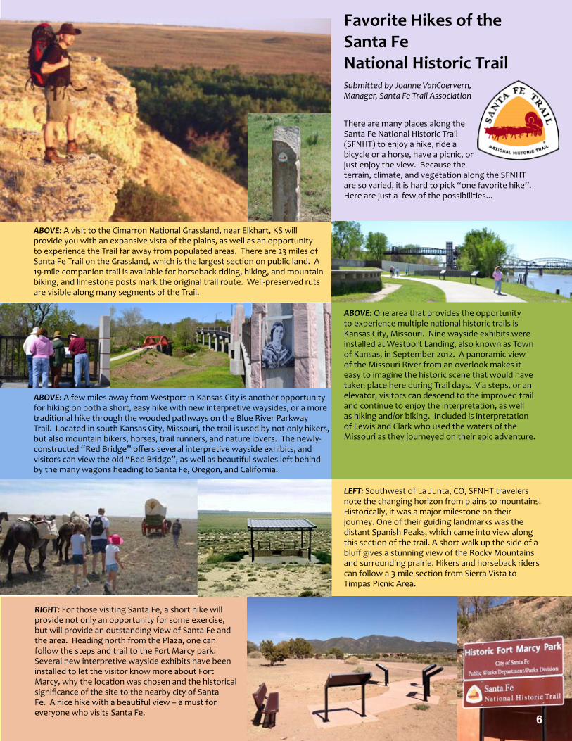
There are many places along the Santa Fe National Historic Trail (SFNHT) to enjoy a hike, ride a bicycle or a horse, have a picnic, or just enjoy the view. Because the terrain, climate, and vegetation along the SFNHT are so varied, it is hard to pick “one favorite hike”. Here are just a few of the possibilities...
ABOVE: A visit to the Cimarron National Grassland, near Elkhart, KS will provide you with an expansive vista of the plains, as well as an opportunity to experience the Trail far away from populated areas. There are 23 miles of Santa Fe Trail on the Grassland, which is the largest section on public land. A 19-mile companion trail is available for horseback riding, hiking, and mountain biking, and limestone posts mark the original trail route. Well-preserved ruts are visible along many segments of the Trail.
LEFT: Southwest of La Junta, CO, SFNHT travelers note the changing horizon from plains to mountains. Historically, it was a major milestone on their journey. One of their guiding landmarks was the distant Spanish Peaks, which came into view along this section of the trail. A short walk up the side of a bluff gives a stunning view of the Rocky Mountains and surrounding prairie. Hikers and horseback riders can follow a 3-mile section from Sierra Vista to Timpas Picnic Area.
RIGHT: For those visiting Santa Fe, a short hike will provide not only an opportunity for some exercise, but will provide an outstanding view of Santa Fe and the area. Heading north from the Plaza, one can follow the steps and trail to the Fort Marcy park. Several new interpretive wayside exhibits have been installed to let the visitor know more about Fort Marcy, why the location was chosen and the historical significance of the site to the nearby city of Santa Fe. A nice hike with a beautiful view – a must for everyone who visits Santa Fe.
ABOVE: A few miles away from Westport in Kansas City is another opportunity for hiking on both a short, easy hike with new interpretive waysides, or a more traditional hike through the wooded pathways on the Blue River Parkway Trail. Located in south Kansas City, Missouri, the trail is used by not only hikers, but also mountain bikers, horses, trail runners, and nature lovers. The newly-constructed “Red Bridge” offers several interpretive wayside exhibits, and visitors can view the old “Red Bridge”, as well as beautiful swales left behind by the many wagons heading to Santa Fe, Oregon, and California.
ABOVE: One area that provides the opportunity to experience multiple national historic trails is Kansas City, Missouri. Nine wayside exhibits were installed at Westport Landing, also known as Town of Kansas, in September 2012. A panoramic view of the Missouri River from an overlook makes it easy to imagine the historic scene that would have taken place here during Trail days. Via steps, or an elevator, visitors can descend to the improved trail and continue to enjoy the interpretation, as well as hiking and/or biking. Included is interpretation of Lewis and Clark who used the waters of the Missouri as they journeyed on their epic adventure.
Favorite Hikes of the Santa Fe National Historic TrailSubmitted by Joanne VanCoervern, Manager, Santa Fe Trail Association
6

National Trails System Collaborative Landscape Planning Initiatives –
7
Sample of a segment profile for the CLP proposalThe CLP National Trails System Proposal included details of each trail segment proposed for acquisition, organized by trail. Each parcel had a profile page describing features, opportunities, and threats to the landscape, as well as a photo of the parcel. Agency staff created and submitted the maps of the parcels. Above: a sample of the format featuring the New England National Scenic Trail.
New England National Scenic Trail
Land and Water Conservation Fund FY2014 Request
its way along the rocky ridges off the 800-acre Penwood State Park. This key property, adjacent to the Park, offers a critical trail connection to the west and is imperative to the scenic viewshed of the trail. Geological features on the property include the west slope traprock ridge, a lateral moraine, and a deep stream ravine. A significant elevation change from 170’ at the Farmington River floodplain to 600’ at the rim of traprock ridge is dramatic. Diverse habitats on the property include deciduous forest in all stages of succession, Lucy Brook with three tributaries, and two vernal pools. The State of Connecticut lists nine animals and eight plants as endangered, threatened, or of special concern on or adjacent to this site.
Benefits of Protection: Protection of two miles of the New England Trail corridor and adjacent scenic and natural resources and preserving the sensitive traprock ridgeline and the watershed of Lucy Brook.
Threats to the Landscape: Destruction of natural and heritage resource, residential development, visual intrusion, and loss of habitat for threatened and endangered species.
Partner Contributions: The Simsbury Land Trust will provide at least $100,000 toward the purchase of this tract and another $150,000 for a dedicated stewardship reserve.
National Trails SystemLand and Water Conservation Fund
Prepared by the Connecticut Forest & Park Association | (860) 346-2372 | www.ctwoodlands.org and the Partnership for the National Trails System | (608) 249-7870 | www.pnts.org
FY2014
Tanager HillPenwood State Park, Connecticut
Project DetailsLWCF Request: $2,000,000
Congressional District: CT-5, Representative Esty
Acres: 91
Miles of Trail: 2
Acquiring Agency: NPS
Landscape Characteristics: The New England Trail winds
New England National Scenic Trail
One of the key features of the Tanager Hill property is 20 acres of open pastureland which is vital habitat for birds and wildlife.
GREENFIELD
SPRINGFIELD
HARTFORD
NEW HAVEN
Avon
Berlin
Bloomfield
Durham
EastGranby
Farmington
Guilford
Haddam
Madison
Meriden Middlefield
Middletown
NewBritain
NorthBranford
Plainville
Simsbury
Southington
Suffield
Wallingford
WestHartford
Erving
Montague
Warwick
Northfield
Southwick
Granby
Pelham
Royalston
Wendell
Agawam
Hadley
Westfield WestSpringfield
Holyoke
SouthHadley
Easthampton
Amherst
Shutesbury
Leverett
CONNECTICUT
MASSACHUSETTS
VERMONT NEW HAMPSHIRE
QuabbinReservoir
Connect
icut
Riv
er
Connecticut
River
Mt Holyoke
Provin Mtn
Mt Higby
Beseck Mtn
Ragged Mtn
Chauncey Peak
Rattlesnake Mtn
Bluff Head
Mt Grace
Mt Lincoln
Mt Norwottuck
Mt Tom
East Mtn
20
20
44
44
44
5
5
5
32
2
2
9
2A
32
56
5
1 1
1
6
202
202
202
202
202
202
84
84
84
84
90
9090
91
95
95
95
91
91
291
391
291
395
691
384
Area ofmap coverage
PA
NY
NJ
CANADA
MEVT
NH
MA
CT RI
Vicinity Map
Mt Nonotuck
Belchertown
9
New Salem
Site 2Site 2
Site 1Site 1
Original data was compiled from multiple source data and may not National Mapping
meet the U.S. Accuracy Standard of the
Office of Management and Budget. This map has no warranties as to its contents or accuracy.
Disclaimer
Legend
New England Trail
Proposed Acquisition Projects
National Park Service Region NER
Connecticut Forest & Park Association
Appalachian Mountain Club
CT Dept of Energy & Environmental Protection
US Fish and Wildlife Region 5
NEW ENGLAND TRAIL TRACTS
FY2014 National Trails System
LWCF Collaborative Funding Proposal
MAP 1 OF 3
This map depicts the approximate locations of proposed acquisitions for Sites 1 & 2 (New EnglandNational Scenic Trail).
Partners
Components of the National Trails System Collaborative Landscape Planning (CLP) Proposal • Overview of the National Trails System• Introduction to the Proposal for the NTS• Letters of support from the
participating national scenic and historic trail stewardship organizations
• NTS map with proposed segments marked (see opposite page)
• Profiles of each proposed segment, including features, potential benefits, and current threats, and photographs
• Individual maps of each proposed segment
FY2014 NTS CLP Proposal at a Glance:• Requested $61,601,508 for land
acquisition• 120 parcels in 17 States and 28
Congressional Districts• 11 national scenic and historic trails
represented, including the Ala Kahakai NHT, the Appalachian NST, El Camino Real de Tierra Adentro NHT, the Continental Divide NST, the Florida NST, the Ice Age NST, the Lewis and Clark NHT, the New England NST, the Nez Perce NHT, the North Country NST, and the Pacific Crest NST
Conservation or preservation of large landscapes is one of the key elements of the America’s Great Outdoors initiative. America’s Great Outdoors is a major interdepartmental and interagency collaborative initiative begun early in President Obama’s first administration and carried out enthusiastically by the Secretaries of the Interior and Agriculture and the Council on Environmental Quality. The large landscape conservation idea is to strategically coordinate the resources of the Federal agencies and nonprofit organizations in various regions to multiply their respective efforts to preserve natural ecosystems for public benefit.
The President’s Fiscal Year 2013 Budget implemented this conservation approach through two multi-million dollar Collaborative Landscape Planning (CLP) projects included in the requests for Land & Water Conservation funding for the National Park Service, U.S. Fish & Wildlife Service, U.S. Forest Service, and the Bureau of Land Management. The two CLP projects funded for 2013 are the “Roof of the Continent” along the Continental Divide in Idaho, Montana, and Wyoming and the “Longleaf Pine Ecosystem” in Florida, Georgia, and South Carolina. The Administration continued the CLP initiative for Fiscal Year 2014 and we were encouraged by Washington land acquisition staff to submit a National Trails System proposal.
The National Trails System CLP Pre-proposal submitted at the end of May 2012 was one of several out of the 40 proposals chosen by an interagency screening team to be considered for inclusion in the President’s 2014 Budget. The National Trails System program leaders for the four land agencies were asked to submit a Final Proposal by early August 2012.
In an unprecedented land conservation effort, the Partnership for the National Trails System and Interagency Trails Council collaborated intensively on the NTS CLP proposal to identify and gather detailed information about priority parcels from both public agency and private trail stewardship organization partners. Parcels were selected based on immediate development threat, scenic, or cultural significance to their respective trails, recreational potential, biodiversity, consideration of adjacent protected or high-potential sites, and endangered and threatened species protection areas. In line with the partnership-fostering goals of America’s Great Outdoors, parcels with many interested and invested parties were given particular priority.
The entire PNTS Conservational Landscape Proposal is available online, as a single document and by trail at: http://www.pnts.org/federal-agency-policy-documents
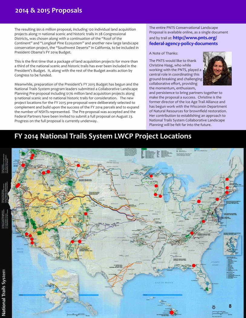
FY 2014 National Trails System LWCF Project Locations
The resulting $61.6 million proposal, including 120 individual land acquisition projects along 11 national scenic and historic trails in 28 Congressional Districts, was chosen along with a continuation of the “Roof of the Continent” and “Longleaf Pine Ecosystem” and another new large landscape conservation project, the “Southwest Deserts” in California, to be included in President Obama’s FY 2014 Budget.
This is the first time that a package of land acquisition projects for more than a third of the national scenic and historic trails has ever been included in the President’s Budget. It, along with the rest of the Budget awaits action by Congress to be funded.
Meanwhile, preparation of the President’s FY 2015 Budget has begun and the National Trails System program leaders submitted a Collaborative Landscape Planning Pre-proposal including $176 million land acquisition projects along 9 national scenic and 10 national historic trails for consideration. The new project locations for the FY 2015 pre-proposal were deliberately selected to complement and build upon the success of the FY 2014 parcels and to expand the number of NSHTs represented. The Pre-proposal was accepted and the Federal Partners have been invited to submit a full proposal on August 23. Progress on the full proposal is currently underway.
FY 2014 National Trails System LWCP Project Locations
2014 & 2015 Proposals
A Note of Thanks:
The PNTS would like to thank Christine Haag, who while working with the PNTS, played a central role in coordinating this ground-breaking and challenging collaborative effort, providing the momentum, enthusiasm, and persistence to bring partners together to make the proposal a success. Christine is the former director of the Ice Age Trail Alliance and has begun work with the Wisconsin Department of Natural Resources for brownfield restoration. Her contribution to establishing an approach to National Trails System Collaborative Landscape Planning will be felt far into the future.
8

In November 2012, the Arizona Trail Association launched a youth outreach, education, and stewardship initiative. Thanks to two grants from Recreational Equipment, Inc. (REI) and Freeport-McMoRan Copper & Gold Foundation, this new program will encourage youth participation in the Arizona Trail through a three-tiered approach: experience, education, and stewardship. The intention is to empower the next generation to take an active role in the enjoyment, development, and protection of the Arizona National Scenic Trail as well as other parks, trails, and public lands throughout the State.
Seeds of Stewardship Step 1 - EXPERIENCE
Deborah Oslik and Kristen Widmark, the ATA’s Youth Outreach & Education Coordinators, coordinate the participation of youth from schools, clubs, and organizations within Arizona Trail Gateway Communities. To help connect youth, families, and communities with their backyard natural resources, student participants experience various forests, canyons, mountains, of the Arizona Trail through hiking, biking, and equestrian day trips and overnight camping adventures.
Arizona Trail Association Launches Seeds of Stewardship Program to Engage Youth
9
Seeds of Stewardship Step 2 - EDUCATION
After youth become familiar with Arizona Trail, hands-on educational activities, materials, and instruction in ecology, botany, biology, geology, and earth sciences are integrated into the outings. Beyond earth sciences, educational lessons will include STEM (Science, Technology, Engineering, and Mathematics) based curricula, as well as adventure education and team-building opportunities.
Through the educational component, youth get to know their local trail and its biotic communities more intimately, develop a greater appreciation for the natural systems in place, and build critical thinking skills. Just as the Arizona Trail connects the Grand Canyon with Mogollon Rim, and the Gila River with the Sonoran Desert, youth will learn how they, too, are connected to all of these places and people throughout Arizona.
Seeds of Stewardship Step 3 - STEWARDSHIP
Once youth have successfully completed the first two components of the program, the third step focuses on stewardship, giving youth an opportunity to play an active role in maintaining, developing, and protecting the Arizona Trail through service projects. From basic trail maintenance and construction to removal of invasive species, youth learn how they can leave a positive impact on their environment. Working alongside professionals from the Forest Service, Bureau of Land Management, National Park Service, and the Arizona Trail Association, youth participate in a series of hands-on projects to build a sense of ownership of the trail and their public lands and learn firsthand what it means to be a “steward.” After a year of experience, education, and service learning, youth will feel that the Arizona National Scenic Trail is their trail.
Assessment of Program Outcomes
Measureable outcomes include:• Number of participant days on the trail• Miles of trail traveled• Number of adults engaged in the program (parents, teachers, educators, mentors and partners)• Miles of trail positively impacted by service learning projects• Amount of educational material learned and retained over the course of the project
Indirect outcomes will include:• Better physical and emotional health of participants• Better test scores from participants• More positive interaction and camaraderie among participants• More positive interaction between participants and their teachers• Positive engagement between youth, their families, and Federal land management agencies• Increased pride in self, community and state
Results from the assessment of this project/service will be used to develop similar programs in other gateway communities along the Arizona Trail and to help secure funding from local, regional, and national sources.
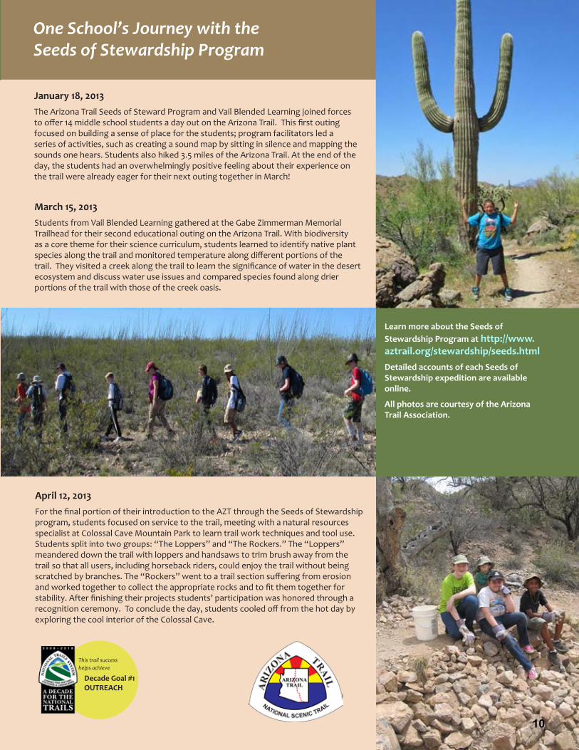
April 12, 2013 For the final portion of their introduction to the AZT through the Seeds of Stewardship program, students focused on service to the trail, meeting with a natural resources specialist at Colossal Cave Mountain Park to learn trail work techniques and tool use. Students split into two groups: “The Loppers” and “The Rockers.” The “Loppers” meandered down the trail with loppers and handsaws to trim brush away from the trail so that all users, including horseback riders, could enjoy the trail without being scratched by branches. The “Rockers” went to a trail section suffering from erosion and worked together to collect the appropriate rocks and to fit them together for stability. After finishing their projects students’ participation was honored through a recognition ceremony. To conclude the day, students cooled off from the hot day by exploring the cool interior of the Colossal Cave.
March 15, 2013 Students from Vail Blended Learning gathered at the Gabe Zimmerman Memorial Trailhead for their second educational outing on the Arizona Trail. With biodiversity as a core theme for their science curriculum, students learned to identify native plant species along the trail and monitored temperature along different portions of the trail. They visited a creek along the trail to learn the significance of water in the desert ecosystem and discuss water use issues and compared species found along drier portions of the trail with those of the creek oasis.
This trail success helps achieve
Decade Goal #1OUTREACH
10
One School’s Journey with the Seeds of Stewardship Program
January 18, 2013 The Arizona Trail Seeds of Steward Program and Vail Blended Learning joined forces to offer 14 middle school students a day out on the Arizona Trail. This first outing focused on building a sense of place for the students; program facilitators led a series of activities, such as creating a sound map by sitting in silence and mapping the sounds one hears. Students also hiked 3.5 miles of the Arizona Trail. At the end of the day, the students had an overwhelmingly positive feeling about their experience on the trail were already eager for their next outing together in March!
Learn more about the Seeds of Stewardship Program at http://www.aztrail.org/stewardship/seeds.htmlDetailed accounts of each Seeds of Stewardship expedition are available online.
All photos are courtesy of the Arizona Trail Association.

11
New Segment of the North Country NST through Tamarac National Wildlife Refuge Officially Opened on National Trails Day!
This trail successsupports
Decade Goal #2PROTECTION
The partners responsible for the new section of the North Country Trail cut the ribbon at the grand opening event. Among the many partners are the Detroit Lakes Area Chamber of Commerce, U.S. Fish & Wildlife Service, Minnesota Department of Natural Resources, North Country Trail Association, Friends of Tamarac National Wildlife Refuge, and the National Park Service. Photo courtesy of the U.S. Fish & Wildlife Service.
By Matthew Davis, ND/MN Regional Trail Coordinator for the North Country Trail Association and Kelly Blackledge, Visitor Services Manager for the U.S. Fish & Wildlife Service’s Tamarac National Wildlife Refuge
Tamarac National Wildlife Refuge (NWR) has been on the North Country National Scenic Trail’s (NCT’s) route since the National Park Service (NPS) published the Comprehensive Plan for the Use and Management of the NCNST in 1982. It wasn’t until the Laurentian Lakes Chapter (LLC) was formed in early 2007, however, that the dream of the NCT traversing the Refuge really began to take shape. As the LLC worked to extend the NCT on other public lands drawing nearer to the Refuge, conversations were started with the U.S. Fish & Wildlife Service (FWS) staff about the NCT’s potential route. Acknowledging the FWS’s primary mission to protect wildlife habitat, careful consideration was given to the route location through the refuge. By mid 2009, the proposed Refuge route was settled upon and the NCT sought grant funding to help construct the NCT northeast of the Refuge boundary and within the Refuge itself.
NCT Grand Opening Event at Tamarac National Wildlife Refuge
The amount of new trail being opened, use of Legacy funds, the variety of partnerships, and the fact that Tamarac is the only National Wildlife Refuge that the NCT currently crosses warranted special celebration. A committee with representation from the NCTA, the LLC Chapter, Tamarac NWR, Friends of Tamarac, and the City of Frazee worked for 6 months to pull together the National Trails Day weekend event.
Noted Minnesota naturalist and nature photographer Stan Tekeila’s presentation on “the Lives of Wolves, Coyote, and Fox” on Friday night in Frazee (a future North Country Trail trail town south of Tamarac NWR) drew over 150 people. A program held on Saturday morning featured an overview of the NCT and NCTA and messages from several of the partners, including the FWS Regional Director Tom Melius, Refuge Manager Neil Powers, and NCNST superintendent Mark Weaver, with NCTA Executive Director Bruce Mathews as MC. Following the remarks, a ribbon strung across the NCT was cut and then cake was enjoyed to celebrate the Tamarac Refuge’s 75th anniversary. Participants enjoyed hikes throughout the day.
Other components of the event included a 14-mile thru-hike across the Refuge and a variety of guided hikes focusing on birding, history, nature photography, hiking with GPS, hiking with kids, and wildflowers. All of these hikes were co-led by volunteers from Tamarac Refuge and the NCTA’s LLC. There was also a short “taste of the trail” hike that left right from the ribbon cutting ceremony that featured edible wild foods. Volunteers with the Friends of Tamarac were on hand to help organize the event.
Legacy Funding springs the project forward
Minnesota voters in 2009 passed the Legacy Amendment which provides dedicated sales tax funding for outdoor heritage, clean water, parks and trails, and projects for the arts. Working through Becker County, the LLC applied for and received a Legacy grant through the Minnesota Department of Natural Resources (DNR) to construct 40 new miles of the NCT using the services of contract crews from the Conservation Corps of Minnesota & Iowa (www.conservationcorps.org). After Minnesota’s environmental review process was completed, several private landowners south of the NWR rescinded their verbal permission and the project was shortened to 25 miles.
The next step was the Sec. 106 Cultural Resources Review on the 25 miles, which was jointly paid for by the two Federal agencies, both in the Department of Interior. The NPS paid for the initial Phase 1a review for the entire project and detailed surveys for the Refuge’s “Johnson Tract” and for all of the trail outside the Refuge. The FWS paid for detailed surveys within the main Refuge. Not unexpectedly, several cultural sites were discovered during the detailed Refuge survey and FWS staff and the NCTA and NPS worked together to re-route several short sections to bypass the cultural sites. The partners also agreed upon a plan to protect a large cultural site through the construction of a long turnpike. Required follow-up surveys for this section within the Refuge were paid for by the NPS while the NCTA and Becker County obtained additional Legacy grant funding for building these structures. After obtaining the approval of the State Historic Preservation Office, trail construction was allowed to commence in June of 2012. The entire approval process took approximately 3 years.
In addition to serving as the applicant and fiscal agent for the Legacy grant funded project, Becker County’s Natural Resources Management Department agreed to host
significant additional segments of the NCT on its tax forfeited lands northeast of the Refuge. Several different Divisions of the Minnesota DNR also agreed to host segments of the NCT on their lands including Forestry, Wildlife, and Ecological and Water Resources (within a Scientific and Natural Area). Two private landowners also agreed to allow short yet critical segments the NCT to pass through their property. One even allowed for a campsite to be established just east of the Refuge boundary to aid long-distance hikers.
Once conditions warranted last year, LLC volunteers started clearing the NCT corridor while Conservation Corps of Minnesota & Iowa crews worked behind them constructing the trail tread. Despite the busy 2012 field season, the NCT through the Refuge was not completely finished as the long turnpike was left until the (unfortunately, very late) spring of 2013. LLC volunteers were working on the turnpike right up until the Grand Opening event.
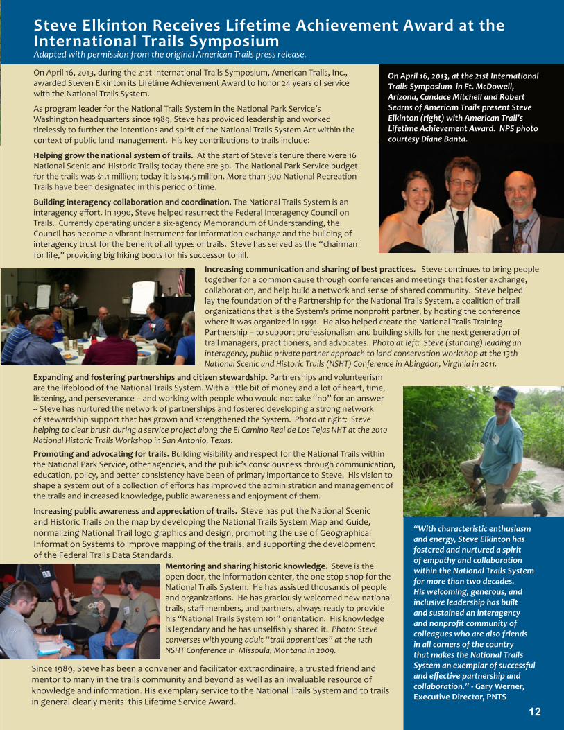
On April 16, 2013, during the 21st International Trails Symposium, American Trails, Inc., awarded Steven Elkinton its Lifetime Achievement Award to honor 24 years of service with the National Trails System.
As program leader for the National Trails System in the National Park Service’s Washington headquarters since 1989, Steve has provided leadership and worked tirelessly to further the intentions and spirit of the National Trails System Act within the context of public land management. His key contributions to trails include:
Helping grow the national system of trails. At the start of Steve’s tenure there were 16 National Scenic and Historic Trails; today there are 30. The National Park Service budget for the trails was $1.1 million; today it is $14.5 million. More than 500 National Recreation Trails have been designated in this period of time.
Building interagency collaboration and coordination. The National Trails System is an interagency effort. In 1990, Steve helped resurrect the Federal Interagency Council on Trails. Currently operating under a six-agency Memorandum of Understanding, the Council has become a vibrant instrument for information exchange and the building of interagency trust for the benefit of all types of trails. Steve has served as the “chairman for life,” providing big hiking boots for his successor to fill.
Steve Elkinton Receives Lifetime Achievement Award at the International Trails SymposiumAdapted with permission from the original American Trails press release.
12
On April 16, 2013, at the 21st International Trails Symposium in Ft. McDowell, Arizona, Candace Mitchell and Robert Searns of American Trails present Steve Elkinton (right) with American Trail’s Lifetime Achievement Award. NPS photo courtesy Diane Banta.
Expanding and fostering partnerships and citizen stewardship. Partnerships and volunteerism are the lifeblood of the National Trails System. With a little bit of money and a lot of heart, time, listening, and perseverance -- and working with people who would not take “no” for an answer -- Steve has nurtured the network of partnerships and fostered developing a strong network of stewardship support that has grown and strengthened the System. Photo at right: Steve helping to clear brush during a service project along the El Camino Real de Los Tejas NHT at the 2010 National Historic Trails Workshop in San Antonio, Texas.
Increasing communication and sharing of best practices. Steve continues to bring people together for a common cause through conferences and meetings that foster exchange, collaboration, and help build a network and sense of shared community. Steve helped lay the foundation of the Partnership for the National Trails System, a coalition of trail organizations that is the System’s prime nonprofit partner, by hosting the conference where it was organized in 1991. He also helped create the National Trails Training Partnership – to support professionalism and building skills for the next generation of trail managers, practitioners, and advocates. Photo at left: Steve (standing) leading an interagency, public-private partner approach to land conservation workshop at the 13th National Scenic and Historic Trails (NSHT) Conference in Abingdon, Virginia in 2011.
Mentoring and sharing historic knowledge. Steve is the open door, the information center, the one-stop shop for the National Trails System. He has assisted thousands of people and organizations. He has graciously welcomed new national trails, staff members, and partners, always ready to provide his “National Trails System 101” orientation. His knowledge is legendary and he has unselfishly shared it. Photo: Steve converses with young adult “trail apprentices” at the 12th NSHT Conference in Missoula, Montana in 2009.
Promoting and advocating for trails. Building visibility and respect for the National Trails within the National Park Service, other agencies, and the public’s consciousness through communication, education, policy, and better consistency have been of primary importance to Steve. His vision to shape a system out of a collection of efforts has improved the administration and management of the trails and increased knowledge, public awareness and enjoyment of them.
Increasing public awareness and appreciation of trails. Steve has put the National Scenic and Historic Trails on the map by developing the National Trails System Map and Guide, normalizing National Trail logo graphics and design, promoting the use of Geographical Information Systems to improve mapping of the trails, and supporting the development of the Federal Trails Data Standards.
Since 1989, Steve has been a convener and facilitator extraordinaire, a trusted friend and mentor to many in the trails community and beyond as well as an invaluable resource of knowledge and information. His exemplary service to the National Trails System and to trails in general clearly merits this Lifetime Service Award.
“With characteristic enthusiasm and energy, Steve Elkinton has fostered and nurtured a spirit of empathy and collaboration within the National Trails System for more than two decades. His welcoming, generous, and inclusive leadership has built and sustained an interagency and nonprofit community of colleagues who are also friends in all corners of the country that makes the National Trails System an exemplar of successful and effective partnership and collaboration.” - Gary Werner, Executive Director, PNTS

13
Juan Bautista de Anza NHT Launches New Website, Publishes Enhanced Trail MapBased upon the official National Park Service press releases, submitted by Naomi Torres, National Park Service.
Photo at Right: Interpreter Melanie Rawlins holds an Anza Trail map in front of the mission at Tumacácori National Historic Park. NPS Photo.
NPS Releases New Anza Trail Map
The Anza Trail and its partners took advantage of a grant from the National Park Service Connect Trails to Parks program to develop and print a brochure, “the Anza Trail in Arizona” to provide an in-depth view of the trail. Printed in both English and Spanish, the brochure presents significant and interesting features of not only the three National Parks along the corridor but also three state parks, areas managed by the Bureau of Land Management, and sites within the Yuma Crossing National Heritage Area.
The brochure was designed and developed by the Western National Parks Association (wnpa.org) who sent out photographers to capture inspiring images of several locations along the trail. With over 300,000 brochures printed, word of the Anza Trail has reached many areas of Arizona. With the help of volunteers, especially Don Kucera of the Anza Trail Coalition of Arizona, the brochure has been distribute throughout Arizona with English and Spanish versions available at National Parks, Arizona State Parks, many historic sites, and at Bureau of Land Management sites.
To reach out to communities that don’t normally visit public lands and historic sites, Anza Trail staff and partners coordinated the brochure distribution
in community spaces such as the Santa Cruz County building and the Mexican Consulate in Tucson. In late April, residents of Yuma received a copy of the brochure in their Sunday newspaper and readers of Bajo el Sol, the Spanish newspaper in Yuma, were treated to the Spanish version.
Top 10 Features of the New Website
www.AnzaHistoricTrail.org10. Search an address for nearby Anza Trail
resources, routes, and recreation trails
9. Zoom to the street level to see if the expedition would have passed by your house
8. Create custom maps of the trail in your community; send a link of your map to your friends
7. Play an animated expedition timeline
6. Read excerpts of the expedition diaries in English and Spanish (courtesy of Web de Anza)
5. Read 19 county-specific guides to the Anza Trail (developed by Anza Expedition descendant Greg P. Smestad, Ph.D.)
4. Watch the film, The Anza Expedition, in English or Spanish
3. Find upcoming cultural and recreation events along the trail, and download Noticias de Anza, the trail’s quarterly electronic magazine
2. Connect with the Anza Trail Foundation; AnzaHistoricTrail.org also serves as a site for the official nonprofit fundraising partner of the Anza Trail
1. Be part of the story: Add your information or photos of trail resources using the MapCollaborator portal
In 1775-76, Captain Juan Bautista de Anza led more than 240 men, women, and children on a perilous overland journey from present-day Mexico to establish the first colonial settlement at San Francisco Bay, a route now commemoriated by the Juan Bautista de Anza National Historic Trail. The Anza NHT and the Anza Trail Foundation have launched www.AnzaHistoricTrail.org — an online Anza Trail experience to connect communities with history, culture, and outdoor recreation along the trail’s 1,200-mile corridor.
The new AnzaHistoricTrail.org is a dynamic online experience that maps the legacy of the Anza Expedition throughout present-day California and Arizona. The website’s backbone is cutting-edge web-mapping technology developed by the nonprofit GreenInfo Network. Approximately 36 million people live in the 20 counties through which the trail passes; the website will allow users from any location to tailor the map to create their own Anza Trail experience.
The Anza Trail officially launched the new site on June 27, the date in 1776 when the Anza Expedition families arrived to establish a presidio in San Francisco. Every year on June 27, Los Californianos, an organization that includes descendants of
expedition members, gathers at the Presidio to honor their ancestors’ legacy.
The new website will serve as the online home for the Anza Trail, including the online magazine Noticias de Anza, and a list of trail-related events. It complements and incorporates the trail’s other online resources, including: Web de Anza, the University of Oregon’s database of primary resources relating to the expedition; the Anza Trail Guide, by Anza Expedition descendant, Greg P. Smestad, Ph.D.; and the National Park Service’s administrative site.
These trail successes help achieve
Decade Goal #1OUTREACH
See for yourself!
You can view the new brochure online at
http://www.nps.gov/juba/planyourvisit/
brochures.htm
Image at left: Screenshot of the new website’s interactive travel map.

Re-enactments Bring to Life the History of the Natchez Trace Parkway Article and photos submitted by Tony Turnbow, Natchez Trace Parkway Foundation
The current major general of the Tennessee Army National Guard, Jackson’s successor in office, places a wreath during the ceremony at the War of 1812 Memorial on the parkway. 14
Living history on the Natchez Trace Parkway took a major step forward this year through re-enactments for the bicentennial of the War of 1812. The first living history event to span the entire length of the parkway recreated the 1813 marches of Major General Andrew Jackson and his Tennessee militia. It was on the 1813 return march on the trace that Jackson earned the name “Old Hickory” for his toughness and refusal to abandon his troops.
Over 2,000 eighth grade students visited education stations along the parkway and listened as re-enactors portrayed historic characters present on the Natchez Trace 200 years earlier. Much of the historic trace traversed the Chickasaw and Choctaw Nations in 1813. Students were surprised to be issued passports they would have needed in the early 1800s to travel the road.
American Indian groups joined the effort to tell the stories of their nations. The Chickasaws were honored for assistance their chiefs George and Levi Colbert provided in feeding Jackson’s soldiers to prevent them from starving on the marches. Robert Thrower, Native Historic Preservation Officer of the Poarch Band of Creek Indians discussed the consequences of the War of 1812 on American Indians along one of the Trail of Tears sites near the parkway. The Mississippi Band of Choctaw Indians honored the role of their chief Pushmataha in the war. The commemoration began a new discussion of a time when the American Indians worked as partners with Jackson to repel a foreign invasion. As bicentennial hickory trees were planted along the route, visitors were reminded that Jackson became “Old Hickory” with the help of his American Indian allies.
More than 100 historians, scholars, and active and retired military personnel traveled from across the nation to lend their expertise to re-creating Jackson’s volunteers. Re-enactors provided a living dimension to interpretation of the story by camping at known 1813 campsites and walking along the same path taken by the soldiers.
Beginning with a re-creation of the 1813 parade of Jackson’s troops through Natchez, Mississippi, and ending with a wreath-laying ceremony at Jackson’s grave outside Nashville, living history portrayals drew attention to the almost forgotten role of the Natchez Trace during the war. The connections of the old trail to historic events in nearby towns were emphasized in events such as a ceremony at the old Mississippi State Capitol building in Jackson, Mississippi.
As events commemorated the significance of the historic route in the war, they also reaffirmed one of the main reasons the trail story was preserved through creation of a national parkway. Ceremonies at the graves of soldiers who died during the marches and at the new War of 1812 memorial site on the parkway emphasized the sacrifices and the stories of heroism that early parkway promoters sought to perpetuate on a national scale.
Parkway supporters followed the advance of the re-enactors up the trail on social media. Newspapers in some towns along the parkway also covered the “troop” movements and announced when they would arrive for events in their town.
Rather than devoting time and energy to a one-time commemoration, the Natchez Trace Parkway Association worked to maximize long-term benefits. Video and still photography from the events will be used for a new cellphone tour of the parkway. Contributions of equipment and the enlistment of additional volunteers during the event builds a new capacity for the association to meet is goal of enhancing the visitor experience through a permanent living history programming.
Robert Thrower of the Poarch Band of Creek Indians and Robert Perry of the Council of Chickasaw Elders. The Trail of Tears NHT intersects the Natchez Trace Parkway.
Over 2,000 students visited sites along the parkway.
LIving history re-enactors recreated the marches of General Andrew Jackson and the Tennessee militia.
This trail success helps achieve
Decade Goal #1OUTREACH
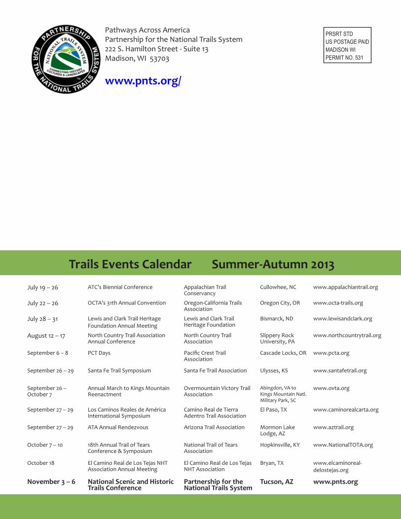
Pathways Across AmericaPartnership for the National Trails System222 S. Hamilton Street - Suite 13Madison, WI 53703
www.pnts.org/
PRSRT STDUS POSTAGE PAIDMADISON WIPERMIT NO. 531
Trails Events Calendar Summer-Autumn 2013
July 19 -- 26 ATC’s Biennial Conference Appalachian Trail Conservancy
Cullowhee, NC www.appalachiantrail.org
July 22 -- 26 OCTA’s 31th Annual Convention Oregon-California Trails Association
Oregon City, OR www.octa-trails.org
July 28 -- 31 Lewis and Clark Trail Heritage Foundation Annual Meeting
Lewis and Clark Trail Heritage Foundation
Bismarck, ND www.lewisandclark.org
August 12 -- 17 North Country Trail Association Annual Conference
North Country Trail Association
Slippery Rock University, PA
www.northcountrytrail.org
September 6 -- 8 PCT Days Pacific Crest Trail Association
Cascade Locks, OR www.pcta.org
September 26 -- 29 Santa Fe Trail Symposium Santa Fe Trail Association Ulysses, KS www.santafetrail.org
September 26 -- October 7
Annual March to Kings Mountain Reenactment
Overmountain Victory Trail Association
Abingdon, VA to Kings Mountain Natl. Military Park, SC
www.ovta.org
September 27 -- 29 Los Caminos Reales de América International Symposium
Camino Real de Tierra Adentro Trail Association
El Paso, TX www.caminorealcarta.org
September 27 -- 29 ATA Annual Rendezvous Arizona Trail Association Mormon Lake Lodge, AZ
www.aztrail.org
October 7 -- 10 18th Annual Trail of Tears Conference & Symposium
National Trail of Tears Association
Hopkinsville, KY www.NationalTOTA.org
October 18 El Camino Real de Los Tejas NHT Association Annual Meeting
El Camino Real de Los Tejas NHT Association
Bryan, TX www.elcaminoreal-delostejas.org
November 3 -- 6 National Scenic and Historic Trails Conference
Partnership for the National Trails System
Tucson, AZ www.pnts.org