A Project to Design, Implement, and Populate an Effective ...
73
Regis University ePublications at Regis University All Regis University eses Spring 2011 A Project to Design, Implement, and Populate an Effective Geodatabase in Order to Re-Organize Geographic Information Systems Instructional a Small Community College James C. Gibbons Regis University Follow this and additional works at: hps://epublications.regis.edu/theses Part of the Computer Sciences Commons is esis - Open Access is brought to you for free and open access by ePublications at Regis University. It has been accepted for inclusion in All Regis University eses by an authorized administrator of ePublications at Regis University. For more information, please contact [email protected]. Recommended Citation Gibbons, James C., "A Project to Design, Implement, and Populate an Effective Geodatabase in Order to Re-Organize Geographic Information Systems Instructional a Small Community College" (2011). All Regis University eses. 467. hps://epublications.regis.edu/theses/467
Transcript of A Project to Design, Implement, and Populate an Effective ...

Regis UniversityePublications at Regis University
All Regis University Theses
Spring 2011
A Project to Design, Implement, and Populate anEffective Geodatabase in Order to Re-OrganizeGeographic Information Systems Instructional aSmall Community CollegeJames C. GibbonsRegis University
Follow this and additional works at: https://epublications.regis.edu/theses
Part of the Computer Sciences Commons
This Thesis - Open Access is brought to you for free and open access by ePublications at Regis University. It has been accepted for inclusion in All RegisUniversity Theses by an authorized administrator of ePublications at Regis University. For more information, please contact [email protected].
Recommended CitationGibbons, James C., "A Project to Design, Implement, and Populate an Effective Geodatabase in Order to Re-Organize GeographicInformation Systems Instructional a Small Community College" (2011). All Regis University Theses. 467.https://epublications.regis.edu/theses/467

Regis University College for Professional Studies Graduate Programs
Final Project/Thesis
Disclaimer
Use of the materials available in the Regis University Thesis Collection (“Collection”) is limited and restricted to those users who agree to comply with the following terms of use. Regis University reserves the right to deny access to the Collection to any person who violates these terms of use or who seeks to or does alter, avoid or supersede the functional conditions, restrictions and limitations of the Collection. The site may be used only for lawful purposes. The user is solely responsible for knowing and adhering to any and all applicable laws, rules, and regulations relating or pertaining to use of the Collection. All content in this Collection is owned by and subject to the exclusive control of Regis University and the authors of the materials. It is available only for research purposes and may not be used in violation of copyright laws or for unlawful purposes. The materials may not be downloaded in whole or in part without permission of the copyright holder or as otherwise authorized in the “fair use” standards of the U.S. copyright laws and regulations.

A PROJECT TO DESIGN, IMPLEMENT, AND POPULATE AN EFFECTIVE
GEODATABASE IN ORDER TO RE-ORGANIZE GEOGRAPHIC INFORMATION
SYSTEMS INSTRUCTION AT A SMALL COMMUNITY COLLEGE.
A PROJECT
SUBMITTED ON 27 MAY 2011
TO THE DEPARTMENT OF INFORMATION TECHNOLOGY
OF THE SCHOOL OF COMPUTER & INFORMATION SCIENCES
OF REGIS UNIVERSITY
IN PARTIAL FULFILLMENT OF THE REQUIREMENTS OF MASTER OF SCIENCE IN
COMPUTER INFORMATION TECHNOLOGY
BY
James C. Gibbons
APPROVALS
Shari Plantz-Masters, Project Advisor
Ranked Faculty Name
Ranked Faculty Name

i
Abstract
Geographic information systems instruction at a small community college was deemed
inadequate by instructional staff and students. Inadequate resources and inefficient organization
of data resulted in frustration for all users. Slow infrastructure resulted in excessive time needed
to complete student projects and precluded the course objectives to be fully met.
A project was completed to define requirements and recommendations, obtain necessary
upgrades to both hardware and network infrastucture, reorganize data storage in a local
geodatabase, and institute methods for more efficient instruction using ArcView and ArcCatalog
applications from the software suite ArcGIS Desktop by ESRI.
Subsequent adoption of the changes to infrastructure and data organization resulted in a
marked improvement in student productivity and a perception of lessened frustration.

ii
Table of Contents
Abstract i
Table of Contents ii
Chapter 1 Introduction 1
Chapter 2 Review of the Literature and Research 8
Chapter 3 Project Methodology 10
Chapter 4 Project History 49
Chapter 5 Conclusions 54
Appendix A Annotated Bibliography 59
Appendix B Project Timeline 66
Appendix C Online Resources for Marine Science GIS Program 67
List of Figures 68

Community College GIS Project 1
Chapter 1 – Introduction
“A project to design, implement, and populate an effective geodatabase with required
hardware and software tools to re-organize geographic information systems instruction
at a small community college.”
Review of existing situation
This project was based on a small community college in the southeast United States
which offered coursework in geographic information systems (GIS) in its Marine Sciences
associate degree program. There was consideration of adding to the offered courses, possibly
developing a certificate and associate degree in GIS, and perhaps continuing education classes. If
added, these additions would fall under the college’s Information Systems department. The
Marine Science program, of which GIS is a part, is focused primarily on the estuary/sound
system located inside the Outer Banks of North Carolina. This specifically includes Albemarle,
Croatan, Roanoke, Currituck and Pamlico Sounds along with the watersheds drainages
associated with each. This area bounds the service area of the college. The GIS coursework in
this program aims to provide basic GIS skills including the ability to create meaningful maps
based on marine science subjects. The college uses the software product ArcGIS Desktop
published by ESRI Incorporated of Redlands, CA for its GIS application.
Initial research on the project subject matter was from casual discussions between faculty
and staff involved in GIS instruction within the Marine Science program. It was apparent that

Community College GIS Project 2
problems existed in the methods of delivery and facilities available. These discussions provided
the rationale for this project. Geospatial data for use both in the GIS coursework and the marine
science program was poorly organized. This resulted in students spending inordinate amounts of
time identifying and acquiring relevant datasets to use in their projects. Students spent more time
chasing data than in utilizing that data to create meaningful maps. Available data sets were
insufficient or difficult to access. There was also a general lack of spatial data connected to the
local region, although such data is available in the public domain. It was just not readily
available, and there was no arrangement for local storage to alleviate this condition. All seven
counties which make up the service area of the college created and maintained GIS data useful to
the GIS program. This data needed to be made available to students without the difficulties
involved with remote acquisition from a multitude of locations. The college needed to institute
an industry-standard geographic information system (GIS) and spatial data structure
(geodatabase) for its marine science program. It also needed to take steps to acquire the relevant
local data where available, such as locally generated datasets, and store it efficiently on site.
The college had not ensured that the IT resources were available and adequate for effective
delivery of the GIS coursework. Hardware provided for the GIS coursework was inadequate, not
conforming to the recommendations of the software provider. It was likely this was causing poor
performance of the software. Network infrastructure lacked optimization for efficient transfer of
large files. Sufficient data storage, including space for student projects, and a provision for
backup, was not provided. Data was not organized using best practices for geodatabase
implementation, and was not an intuitive structure for students.
This set of problems provided the framework for this project:

Community College GIS Project 3
- Difficulty acquiring adequate datasets, both local and non-local
The difficulty acquiring adequate datasets problem manifested itself in unacceptable
amounts of class time locating and downloading data needed for projects. This was
thought to be due to the LAN and WAN performance. Time spent doing this took away
from classroom instruction time and was considered excessive. This seemed to call for
better organization of data, perhaps in a geodatabase structure.
- Slow performance of the software on the classroom hardware
The computers provided for this class were adequate for most classroom instruction in
other courses, but GIS is graphically and computationally driven and requires machines
with adequate speed, memory, and graphical resources. The machines provided were not
up to the task of providing suitable performance for the application.
- Slow performance of the LAN and WAN infrastructure
LAN performance within the class and buildings were not designed for the amount of
data that needed to be transferred. Downloads from the local server were tedious. In
addition, the WAN link to the internet was also undersized for the amount of data
requested, not just from the GIS program, but from other classes who were utilizing the
internet more and more within their curricula.
- Insufficient spatial data storage and inefficient file management
Data management within a GIS depends on connections between the various data used to
build a map document. If a map file is moved, all the links to the data may be lost unless care
is taken to manage the connections relatively instead of absolutely. Windows Explorer can
Community College GIS Project 4
view the data where it exists, but cannot manage the interconnected nature of the map files,
which may join dozens of files existing in different places. ArcCatalog is an included
application within ArcGIS Desktop and should be used for spatial file management. There
was no dedicated storage per se for GIS data storage and student file storage.
Goals of project
The above problem areas define the goals of the project. The first is to identify available data
resources already in use in the GIS classes. Secondly, making arrangements to acquire other
relevant datasets and locally store them. Third is to assess currently current classroom resources
in light of those recommended by the software vendor, and develop recommendations and
eventual implementation of improvements. Also in this area, to work with college MIS to assess
current network capabilities and arrange to provide acceptable data transfer, security, and backup
of the geodatabase and student files. Fourth, a spatial data storage structure must be created to
contain the required spatial datasets, student project files, and locally generated GIS data. This
would require considering different models and methods by which this would best be
accomplished. And last, to arrange for ongoing maintenance of both acquired datasets and
hardware/software upgrades as requirements change.
Barriers and/or issues
Several barriers to the project existed. The GIS program at the college is only taught at
one of three campus locations, 70 miles from the main campus. The MIS department is located at
the main campus, with one MIS technician assigned to the Dare campus. With the relatively
small size of the program, funding has been problematic. There existed no dedicated budget code
Community College GIS Project 5
for the program, and support was spread between the Marine Science program, MIS, and the
Information Systems department. As this program existed only at the remote campus, visibility
of the needs of this small program was difficult to maintain.
In the area of data acquisition, some agencies were more willing to provide datasets than
others, although almost all these data are generated at public expense. Whether from a reluctance
to share the data, or the trouble to provide it, some data were more difficult to acquire than
others. For more distant agencies such as NASA and NOAA, there was the drudgery of
identifying downloadable or otherwise available datasets likely to be useful to the coursework.
For the classroom hardware and network infrastructure part of the project, there had been
reluctance to commit to long term funding for software and hardware acquisition for the program
by administration. A commitment to a budget item for ongoing maintenance would be needed to
ensure ongoing program viability but did not exist. Hardware and network resources have been
provided by the college’s MIS organization by purchase, normal replacement, reconfiguration, or
reassignment. Policy requires use of certain manufacturers to maintain conformity within the
MIS organization, which may or may not be limiting for the purposes of this project.
This program falls under the management of the academic computing infrastructure, as
opposed to MIS systems project, but academic computer lab has no hardware budget. It is
therefore supported only marginally by MIS. Ongoing maintenance of the geodatabase and
hardware resources fell to the instructional staff as a collateral duty. The one MIS technician
available on campus provided help as his schedule allowed, but he was not tasked with support
for the system.

Community College GIS Project 6
Scope of project
The scope of the project was limited to the needs of the current coursework and marine
science data storage, without explicit provision for the considered increase in classes or
programs. Currently, only one curriculum class will be affected, GIS 111, Intro to GIS. An
average class has about 15 students. However, the solution would hopefully be sufficiently
scalable to accommodate growth, should it occur. There has been discussion about adding GIS as
a specialty within the general IT curriculum, i.e. AAS Information Technology (GIS). This
would require two or three other courses from the state curriculum GIS offerings, not yet
identified.
To limit the scope, agencies with local data sets were identified and contacted for
inclusion in the geodatabase. This was limited to the college’s service area of seven counties,
which, although large in area, is relatively small in population. Data provided by the software
vendor (base maps and common map elements) were sufficient and didn’t need to be augmented
for the purpose of the coursework. Only external data sources such as NOAA and USGS with
marine science resources found useful for the classes were to be identified and documented, but
only particularly relevant datasets would be acquired. This pertains also to state resources.
On the hardware and network infrastructure part of the project, the goal was to maintain
equipment to at least the minimum standard to run the software and provide efficient data
transfer and security. No extra hardware would be added to the classroom resources unless
mandated by the software. Network performance would be dictated by the college infrastructure,
but optimization, where possible, would be accomplished. Within budget limitations,
recommended system requirements, rather than the minimum requirements specified by the

Community College GIS Project 7
software vendor would be pursued. Transfer speed and data security consistent with generally
accepted standards would be the goal in this area.
This project was somewhat particular to this institution since it concentrates on acquiring
and organizing locally relevant marine and estuarine spatial data, and products of the state,
county, and municipal GIS data producers. It may be useful for other community colleges
considering implementing GIS curricula with a local geodatabase. It may also serve as starting
point for other geodatabase installations with a local flavor. The discussions of hardware and
network requirements also may be relevant to establishing a GIS program or improving an
existing one.

Community College GIS Project 8
Chapter 2 - Review of the Literature & Research
Research and literature specific to the project
The driving reason for this project was dissatisfaction with the existing GIS instruction
by both students and faculty. Long file transfer times, insufficient datasets, and slow hardware
manifested itself in student frustration and consequent pedagogical consequences, perhaps
particularly with struggling students. A University of Washington study found that “inconsistent
and inadequate classroom technologies are another source of frustration to students” and
“students conflated inadequate technologies in classrooms and instructor competence, believing
that lack of facilities indicated a lack of preparedness on instructors’ parts.” (Fournier, Lane &
Mattison, 2010). These interruptions have negative effects on learning (Zijlstra, Roe, Leonora &
Kredict, 1999). Technical problems and interruptions seem to affect some students more than
others, with greater effect on students who might eventually withdraw (Sitzman, Ely, Bell, and
Bauer, 2008). Problems with computer hardware, software, or network congestion may disrupt
classrooms and slow learning. (Lazar, Jones, Hackley and Shneiderman, 2006). Instructors lose
confidence in their teaching ability when technological problems interrupt planned learning
(Tatum, Stephanie L. & Morote, Elsa-Sofia, 2007).
Geographic information systems benefit from intelligent and accessible data storage. A
geodatabase is a term used for a collection of spatial data whether it is in the form of an actual
database structure, such as a relational system, or a method of organizing files in an efficient and
intuitive manner. For some, the geodatabase (as a container) is the preferred method of

Community College GIS Project 9
organization of spatial data (Zeiler, 1999). For others, a simple file system geodatabase is often
preferred for small to moderately sized installations, particularly those with limited concurrent
user requirements (Childs, 2009). The creation and management of a geodatabase are well
covered by several sources: In Modeling Our World, The ESRI Guide to Geodatabase Design,
Zeiler discusses data types and structures in detail (Zeiler, 1999), as he does the component parts
of map documents. Several geodatabase models are available and are suitable for different
instances (“Managing Spatial Data in ArcGIS 9.2”, 2005.) They can be relatively simple and
inexpensive to implement or conversely require costly installations with dedicated staff (Peters,
2008). Since this particular project deals with GIS for marine science, three articles are presented
in Marine Geography: GIS for the Oceans and Seas, (Breman, 2002) which deal with marine
spatial data and its organization.Local datasets should be readily available to students for their
projects. All of seven counties in the college’s service area have GIS data which can be used.
State and local GIS data are considered public records and are available from the agencies on
CD/DVD or via download. The acquired data can be stored locally for easy access in a file
geodatabase (Childs, 2009).
IT resources must be available in acceptable quantity and capacity for an effective GIS
system utilizing a geodatabase. The software publisher provides requirements for its software
versions (Hardware Requirements ArcView 9.2 ,2007). that can be used to model classroom
hardware requirements. Server requirements, network throughput, and security methods need to
provide acceptable performance and safety, including backup (Peters, 2008). Unacceptable
network performance can adversely affect learning (Lazar, Jones, Hackley & Shneiderman,
2006).

Community College GIS Project 10
Chapter Three - Project Methodology
Within the college IT structure, equipment inventories and planning, network architecture
and maps, and planning documents were reviewed and utilized. Phone interviews with the local
government GIS offices and web inquiries led to a list of datasets being produced by those
offices in support of their local users. This included all seven counties in the college’s service
area plus six local municipal governments.
Web searching was utilized to find appropriate providers of data and returned a
significant set of governmental, educational, and agency GIS products available for general use.
A number of these are listed within the project section of this paper. Web searches also provided
several useful papers on the subject of geodatabase design which are included in the bibliography
and cited within the paper. Texts, primarily from the press section of the software publisher
ESRI, were consulted for best practices and systems implementation advice. Methods of project
management were utilized from a text on project management. (Wysocki, Beck, & Crane,
2000), which provided a useful refinement (in the author’s opinion) of the classic systems
development life cycle procedures. This is because the effort undertaken was more of a “project”
than a “system” as it worked with existing infrastructure and software, upgrading and re-thinking
methods of instruction and the delivery of that instruction.
Finally, discussions with students actually involved in the GIS instruction provided
insights into barriers and difficulties, along with approaches that work well. College and campus
administration staff was consulted about planning requirements for software maintenance and
hardware replacement, and the status of both as they affect the GIS program.

Community College GIS Project 11
Scope the Project Phase
College of The Albemarle is a North Carolina community college serving seven counties
in northeastern NC. The perception that the program had problems centered on informal
discussions with both the instructional staff and students. The author was one of the two
instructors. The head of the marine science program had also recieved complaints about the
program. The complaints centered on the following:
-Difficulty acquiring adequate datasets, both local and non-local, for the required -
individual and group projects
-Slow performance of the software on the classroom hardware
-Slow performance of the LAN and WAN infrastructure
-Difficulty in spatial data file management
I agreed to work on the problems and implement solutions. A success in the project would be
defined as a perceived improvement in the classroom delivery of the coursework and reduced
frustration in both instructional staff and students.
Assumptions at the time were that support could be found in the MIS and marine science
department and that some funding would be available to incorporate improvements which would
likely be recommended. A lack of this funding would probably be an obstacle as it was assumed
hardware for both the desktops and network would need to be acquired (or at least re-purposed).
It was also assumed that the college would continue with ESRI’s ArcGIS Desktop software as its
GIS application. Continuing support by the campus administration for the project was also
assumed.

Community College GIS Project 12
The project would entail a number of activities in order to accomplish the goals; these
could be roughly divided into dealing with the data acquisition and management problem, and
the infrastructure situation. These are listed below:
-Data acquisition and management:
-Identify relevant data sources, both local and national
-Formulate a storage strategy for acquired data and student files, based on geodatabase
format
-Implement the storage strategy decided upon, including security and backup
considerations
-Implement measures to alleviate confusion regarding spatial file management
Infrastructure:
-Identify minimum and/or recommended hardware requirements for GIS software use
-Identify network infrastructure existing and possible upgrades within the strictures of
college IT policies and resources
-Identify available hardware for utilization in geodatabase storage design, or acquire new
hardware to implement solution
-Implement infrastructure and hardware modifications as identified above
The time requirements for each area were completely dependent on the amount of time
that could be given to the project. The project was done in addition to normal workload. Since

Community College GIS Project 13
there was only one participant in the project, the time horizon was somewhat open-ended, with
the aim of having the project completed and installed by the summer semester of 2008, for use in
the spring semester of 2009, when the GIS curriculum course would again be offered. Since the
decision to work on changing the GIS instruction was made in the spring of 2007, this gave a
two year overall timeline informally set and accepted as the goal. A general project timeline is
provided in Appendix B.
Resources available for the project were unknown, but general support by administration
lent encouragement that identified requirements could be funded. As with many institutions,
resources vary from year to year depending on state budgets. It was considered likely that the
curriculum PCs would require upgrade or replacement, along with the display devices. A place to
store the acquired data and student files indicated need for a server, along with backup
provisions, and underlying network infrastructure was suspected of being inadequate for large
file transfers to and from a server for up to 24 concurrent students. This could mean upgraded
network switches, or reconfiguration of existing equipment. It was known that some LAN
switches were 10BaseT and would likely need to be upgraded to 100 mbps as a minimum.
It was unknown if payment would be required to acquire the important local datasets
available throughout the seven county service area. Although considered public domain in NC,
there may be charges for copying and media. Additionally, if useful national or international
datasets were identified that required purchase or licensing, this could be an additional expense.
It was generally accepted that data acquisition costs would be minimal.
The project would therefore align itself along the dual courses of the data piece and the
infrastructure piece. These would be worked on concurrently as time permitted, beginning with

Community College GIS Project 14
the analysis of the existing conditions. This would lead to identifying the necessary upgrades,
acquiring them, locating the data sources needed to populate the geodatabase, and acquiring
them. File management techniques would then be developed.
Launch the Plan
The team that would be be involved with the project was limited to several people to
provide guidance and advice on college policy, and myself to do the work. The GIS instruction
staff and marine science director were in agreement with the goals listed above, as they were
developed in close consultation with them. As far as analysis, design and implementation, the
author was the team.
The project would have to proceed as time allowed, but with a goal that the project would
be implemented by the spring semester 2009 GIS class. There was no need to have formal
project updating, as there was no “team” to keep updated. The author was in control of
requesting and allotting all resources, so no problems evolved with a fair distribution of
resources. This is not to say that all resources requested were forthcoming.
Here is where the work of “doing” the project happened. It was decided to work on both
the data piece and the infrastructure piece at the same time, and as opportunity presented itself.
In this way, as decisions were awaited or information was being waited for, work could proceed
on other, unrelated areas. Instead of waiting for the MIS department to consider and decide on
recommendations for modifications or the acquisition of new equipment, data sources could be
identified and the acquisition could be started.
The infrastructure part of the project will be described first, and then the data acquisition and
management part will be discussed. However, both activities were ongoing at the same time.

Community College GIS Project 15
Infrastructure
The workstations available were analyzed along with the recommendations for the same by the
software manufacturer ESRI. As the project started the curriculum was using version 8.3 of
ArcGIS. In early 2008 version 9.2 was adopted as part of our software subscription service. The
College maintains a license for 25 classroom copies, plus 2 for instructional staff. Significant
changes to the hardware recommendations occurred with this switch, emphasizing the need for
this project. Table 1 is taken from ESRI’s recommendations as posted (Hardware Requirements
ArcView 8.3,2003) and (Hardware Requirements ArcView 9.2, 2007). The configuration of the
existing hardware is given Tablel 2. A photo of an existing workstation, which was in use at the
beginning of the project but is no longer used for GIS is provided as Figure 3.1. Note the CRT
15” monitor, which made working on maps uncomfortable due to the graphics nature of the
work.

Community College GIS Project 16
Table 1
Requirements and Recommendations for ArcGIS software versions 8.3 and 9.2
Minimum Requirements (PC-Intel)
ArcGIS 8.3 ArcGIS 9.2
CPU Speed 450 MHZ 1.6 GHZ
Processor Pentium Intel Pentium 4
Memory 128 MB 1 GB
Swap Space 300 MB 500 MB
Disk Space 605 MB (NTFS) 1.2 GB
Graphics 16MB video card 32 MB 24-bit
OS XP Pro Home SP1 XP Pro Home SP1
Recommended Configurations (PC-Intel)
ArcGIS 8.3 ArcGIS 9.2
CPU 650 MHZ or more ^1.6 GHZ
Processor ^ Pentium Xeon, Core Duo
Memory 256 MB or more 2 GB
Swap Space ^300 MB ^ 500 MB
Disk Space same same
Graphics 32MB video card 64 MB 24-bit
OS XP Pro Prof. SP1 XP Pro Prof SP3
As is evident from the comparison, the move to version 9.2 requires a significant hardware
upgrade.

Community College GIS Project 17
As the baseline for the beginning of the project, the Table 2 gives the minimum and
recommended configurations for ArcGIS 8.3, along with the workstation configuration existing
at the time:
Table 2
Comparison of requirements and existing hardware
ArcGIS 8.3
Minimum
ArcGIS 8.3
Recommended
Existing PCs in
GIS Class
CPU Speed 450 MHZ 650 MHZ or more 1.2 GHZ
Processor Pentium ^ Pentium Pentium 4
Memory 128 MB 256 MB or more 512 MB
Swap Space 300 MB ^300 MB OS dependent
Disk Space 605 MB (NTFS) same Adequate
Graphics 16MB video card 32 MB video card Integrated,
shared memory
OS XP Pro Home SP1 XP Pro Prof SP1 XP Pro,
Ver.2002, SP1

Community College GIS Project 18
Figure 3.1 Initial workstation with 15” CRT monitors
It was apparent from the table that in most respects, the hardware seems to comply with
the requirements of ArcGIS 8.3, the version of the ESRI software used by the College. The
major problem with the setup as configured is that instead of a dedicated video card with its own
memory, the graphics subsystem is integrated on the system board (motherboard) and shares the
system memory. This was a much less desirable setup from a system point of view for two
reasons. First, shared system memory is slower than dedicated video memory. Secondly, the
amount of shared memory is taken away from the operating system to use for the applications.
This caused distinctly slow rewrites of maps as they are regenerated on screen each time they are
updated or new elements are added.
Also, the 15” Compaq CRT monitors were quite small for GIS work. At a reasonable
scale for detailed work, it requires panning and scrolling to move throughout the document.

Community College GIS Project 19
Although not given as a requirement in the table at Table 1, in general the “bigger is better”
axiom is true for GIS and other graphics-intensive work.
It was also apparent from the chart that once version 9 of the ArcGIS software was
adopted, the current hardware configurations would be out of specification. This would need to
be mitigated before the next GIS classes, which would be using the newer version of the
software in order to keep up with industry standards. Discussion with the IT management of the
college made them aware of the discrepancies and made an appeal to upgrade the GIS lab
machines.
The college IT department utilized a “cascade” method of hardware upgrades, in which
higher classrooms and those with higher performance needs are upgraded as equipment purchase
money becomes available, and those machines are cascaded down to labs with less stringent
hardware requirements. The lab used for GIS instruction is a 24 seat classroom, and was
normally a recipient of first-order machines, but was not due for upgrade until 2009. A decision
was taken to upgrade the lab in 2008 with new machines. The configuration of these new
workstations is given below in Table 3. Along with the new workstations, 17” LCD monitors
were also provided as an upgrade.

Community College GIS Project 20
Table 3
ArcGIS Requirements and Recommendations with new workstations specifications (Hardware
Requirements ArcView 9.2 , 2007)
This of course was a very welcome upgrade.The machines were compliant with the
recommended, as opposed to minimum, requirements. The machines still did not have dedicated
video cards to offload the graphics work from the processor, and the memory is still shared,
although there is a more of it. With the 2GB of memory, performance was noticeably improved
and the larger, LCD monitors were much more comfortable for graphics Although 19” monitors
were requested, the equipment provided has proven adequate and a great improvement.
This equipment was available for both the 2008 and 2009 GIS classes, and is due for
upgrade in 2012. It is hoped that further versions of ArcGIS do not again get ahead of the normal
ArcGIS 9.2
Minimum
ArcGIS 9.2
Recommended
New PC
Workstations
CPU Speed 1.6 GHZ ^1.6 GHZ 1.83 GHZ
Processor Intel Pentium 4 Xeon, Core Duo Core Duo 6300
Memory 1 GB 2 GB 2 GB
Swap Space 500 MB ^ 500 MB OS dependent
Disk Space 1.2 GB same adequate
Graphics 32 MB 24-bit 64 MB 24-bit Integrated,
shared memory
OS XP Pro Home SP1 XP Pro Prof SP3 XP Pro,
Ver.2002, SP3

Community College GIS Project 21
upgrade cycle which is now in place for the GIS program labs. Below (Figure 3.2) is a photo of
the new lab workstations:
Figure 3.2 GIS Lab with new workstations
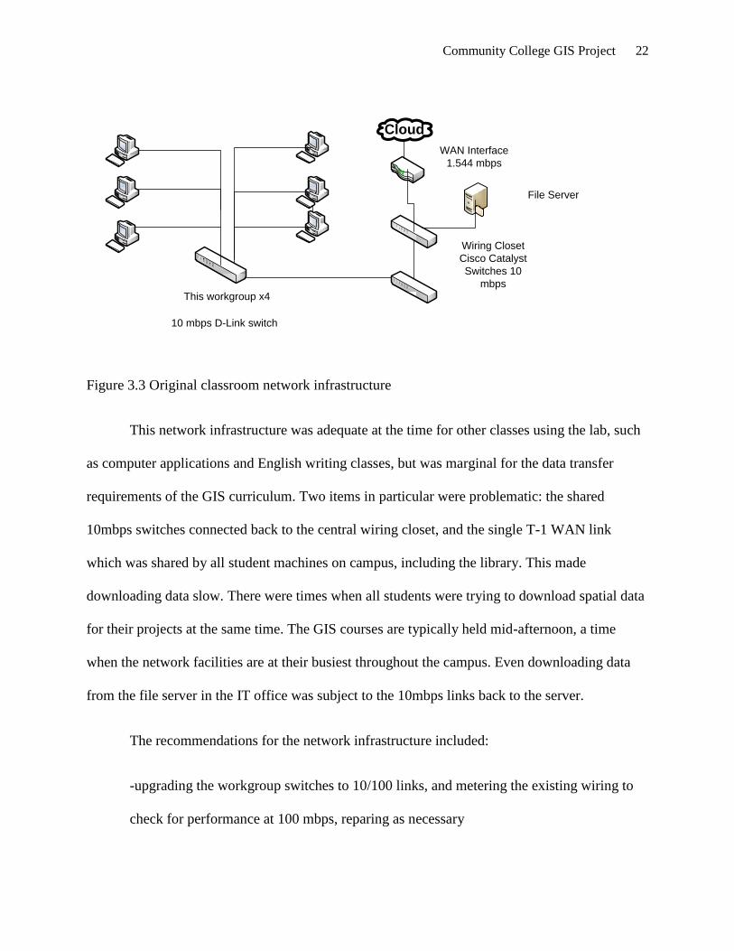
The network infrastructure in place at the beginning of the project consisted of D-Link
10Mbps classroom switches, each servicing 6 workstations, connected via the structural wiring
to a central switch in the network infrastructure closet. This central switch interconnected with
other local switches and provided access to the WAN interface used for student internet access.
These central switches were Cisco Catalyst 10BaseT units. The WAN interface was a T-1 1.544
mbps dedicated line into the State of NC’s leased IT infrastructure. Figure 3.3 gives a
generalized view of the existing network infrastructure as the project began.
Community College GIS Project 22
This workgroup x4
Cloud
WAN Interface
1.544 mbps
Wiring Closet
Cisco Catalyst
Switches 10
mbps
10 mbps D-Link switch
File Server
Figure 3.3 Original classroom network infrastructure
This network infrastructure was adequate at the time for other classes using the lab, such
as computer applications and English writing classes, but was marginal for the data transfer
requirements of the GIS curriculum. Two items in particular were problematic: the shared
10mbps switches connected back to the central wiring closet, and the single T-1 WAN link
which was shared by all student machines on campus, including the library. This made
downloading data slow. There were times when all students were trying to download spatial data
for their projects at the same time. The GIS courses are typically held mid-afternoon, a time
when the network facilities are at their busiest throughout the campus. Even downloading data
from the file server in the IT office was subject to the 10mbps links back to the server.
The recommendations for the network infrastructure included:
-upgrading the workgroup switches to 10/100 links, and metering the existing wiring to
check for performance at 100 mbps, reparing as necessary

Community College GIS Project 23
-upgrading the central switches to 100 mbps per port
-upgrading the WAN infrastructure to provide greater bandwidth to the internet cloud
-consider using VLANs in the central Cisco switches to isolate and give priority to the
GIS lab machines
These recommendations were made as requests to the MIS department after consultation
with the network administrator and technicians. All three required expenditures in a finance
environment that is always tight. However, some of the perceived shortcomings were due to be
alleviated during scheduled college and statewide upgrades. For instance, the central network
switches were due to be replaced with Cisco 10/100mbps units, and the state was expected to
upgrade the existing WAN link from 1 T-1 line (1.544 mbps) to 3 T-1s in 2008.
This left the workgroup switches. Money was found in the curriculum supply funds to
cover the purchase of these low-cost switches as they were less than $100 apiece. 4 Netgear
10/100 mbps switches were purchased and installed. Of course, their full benefit would not be
realized until the central switches were also 10/100. The existing CAT-5 wiring was checked by
staff with a Fluke network analyzer and found adequate to 100mbps. Eventually both the central
switches and the WAN link were upgraded to the above capacities, and more recently the WAN
link was upgraded to the equivalent of 6 T-1 links via a new telcom connection to the state IT
system.
It was decided that with the new capabilities, there was no need to establish a VLAN in
the central switches. This removed some maintenance complexity and so far has not been
noticed. It has recently been requested, however, that with the new geodatabase server
subsystem, access to that resource be restricted in order to provide control and security. As

Community College GIS Project 24
currently configured, a generalized view of the current network infrastructure is provided in
Figure 3.4 .
This workgroup x4
Cloud WAN Interface
6 x 1.544
mbps
Wiring Closet
Cisco Catalyst
Switches 10/
100/1000
mbps10/100 mbps Netgear
switch
Remotely located
geodatabase
Server and Plotter
100 mbps CAT-5
Possible VLAN for
access control in
switch
Figure 3.4 Current classroom network infrastructure
As much as this is a significant improvement to the LAN/WAN infrastructure that existed
at the beginning of the project, it didn’t completely alleviate the problems of data acquisition.
Increased internet use by the rest of the campus was noted as more and more classes utilized rich
media content in the classrooms, along with additional bandwidth use by students for such
applications as Facebook and other social networking sites. However, it is much more useable.
The increased capacity, along with the local availability of some data on a new, dedicated
geodatabase server (which we will discuss next), has helped students be more efficient in their
project map making. It is a long way from the original configuration that was in place at the
beginning of the project.

Community College GIS Project 25
At the beginning of the project, students acquired data for use in their assignments and
projects either via their data CD from their texts, from a shared-use file server located on the
network, and data downloaded via the internet and stored on curriculum PCs or USB drives. Of
course data available on their on CDs was efficient to access and utilize, but was only for use in
the assignments from their text. Data provided by the software publisher ESRI was housed on a
file server which also served other purposes such as instructor file space allocations and backup
space for instructor machines. The machine at that time was a Compaq server running a Novell
operating system. Student PCs were mapped to the GIS data section.
In order to reorganize the GIS data into a geodatabase, a dedicated server that could be
more easily maintained by the GIS instructional staff (as far as data was concerned) was
recommended. Operating system maintenance, backup scheduling, antivirus updating would be
under the control of the MIS staff.
The college purchased only Hewlett-Packard and Compaq computers, so the MIS
department was asked to specify a machine that would provide relatively large storage, fast file
transfer capability, and have backup and security features available. It would preferably be
housed in a space that the instructional staff could access to load or remove datasets as
necessary. Funds were found in the campus Technical Education budget to purchase, within
limits, the server. This funding was possible since the GIS program, existing within the marine
science curriculum, is supported by the Technical Education program. The Computer Science
and Electronics Technology (CSET) department had an extra licensed copy of Microsoft Server
2003 which could be utilized on the new server. A rack mounted HP server was acquired.

Community College GIS Project 26
The server was housed in a typical 19” equipment rack in the CSET department’s lab
located next door to the classroom where GIS instruction is held. It was connected back to the
network via CAT 5E cabling at 100 mbps to a central switch where it is accessible via the LAN.
It was provided with a UPS and is connected via a proxy server to the internet. Initially, an older
Digital DLT tape drive was to be used for local backup, but a 250 GB Seagate external USB
drive was acquired to provide for backup. A photo of current setup is below (Figure 3.5)
Figure 3.5 Geodatabase server and peripherals

Community College GIS Project 27
In addition, we were able to also acquire a printer/plotter that was not considered in the
initial hardware analysis. It does, however, provide a means of displaying student maps in a large
format for hanging locally. It is a Hewlett-Packard 800, and will accept up to 42” paper. Students
are impressed to see their work produced in such large format, and carefully edit their final maps
for the best display. It is network attached and is mounted in the CSET lab with the server. A
photo is provided as Figure 3.6.
Figure 3.6 Hewlett-Packard 800 Plotter/ Printer
This ends the discussion of the infrastructure modifications that occurred due to the
project. From a slow network and limited graphics, the infrastructure now provides much

Community College GIS Project 28
improved support for both the GIS application ArcGIS, and for the acquisition of the important
datasets required for the production of meaningful maps, which is a cornerstone of the
instruction.
Data Acquisition and Management
It was specified earlier that the project would address the following items related to data
acquisition and file management:
-Identify relevant data sources, both local and national
-Formulate a storage strategy for acquired data and student files, based on geodatabase
format
-Implement the storage strategy decided upon, including security and backup
considerations
-Implement measures to alleviate confusion regarding spatial file management
During the two years that this project was ongoing, means of data acquisition became less
dependent on individual requests to agencies, especially on the local/state level, as much had
been made available online for download. Although this is useful for removing some
complication from the procedure, not all data is made readily available, and is still available only
by request. Mostly, tax maps and parcel delineations are available from the counties. However,
some projects require more detailed information on such items as water and sewerage lines and
facilities. These data still need to be provided via optical media whenever possible. Two counties
have provided a set of DVDs with nearly all their mapping resources, and this data can be stored
on the network and accessed speedily and readily.

Community College GIS Project 29
Local data resources make it possible for project maps to be produced which relate to the
college’s service area. Students can then see the relevance of the skills developed and apply it to
particular needs of their communities. This was an aim of the instruction. County spatial data for
the college’s service area (seven counties) is useful to students who often choose to construct
their map projects on local or regional themes. All counties were contacted regarding their
willingness to provide relevant datasets to the college for inclusion in the geodatabase to be used
for GIS instruction. A list of web resource information is available in Appendix B.
All seven counties of the service area either border on one of the four sounds which are
studied in the marine science coursework or contain watersheds that empty into them. A list of
county contact information is provided as an appendix. In general, all counties can provide tax
maps, plot plans, and zoning maps. Most can provide aerial photos, though varying in scale and
date of production. There is an entity called The Albemarle Regional GIS site which is
maintained by Camden, Currituck, Pasquotank, Perquimans, Gates, and Washington counties. It
is something of a clearinghouse for available GIS data, and is in addition to the counties’ other
GIS offerings on the web.
The State of North Carolina maintains several GIS portals or clearinghouses useful to the
project. During the course of the project, these have become more robust and easier to use. Three
of the more important resources are NC Center for Geographic Information and Analysis (CGIA)
and its NC OneMap, the NC State University portal, and the Department of Environment and
Natural Resources. These sites are briefly described below.

Community College GIS Project 30
NC Center for Geographic Information and Analysis and its NC OneMap provides a one stop
resource for much material generated within the state. CGIA describes itself: (NC Center for
Geographic Information and Analysis):
“The Center for Geographic Information and Analysis (CGIA) is the lead agency for
geographic information systems (GIS) services and GIS coordination for the State of
North Carolina. CGIA provides GIS services to state and local governments as well as
the private sector. The Coordination Program brings the statewide community together
to promote data sharing, informed decision-making, and cost efficiencies.”
NC OneMap is an initiative of CGIA. Its purpose is given as “NC OneMap is a public
service providing comprehensive discovery and access to North Carolina’s geospatial data
resources. It is an organized effort of numerous partners throughout North Carolina, involving
local, state, and federal government agencies, the private sector and academia. It is the geospatial
backbone supporting North Carolina data users. NC OneMap is the State Clearinghouse for
geospatial information. (NC OneMap site at http://www.nconemap.com ).
NC OneMap has proven to be invaluable in locating datasets for the GIS students,
particularly for their project maps. It offers NC datasets in many categories including
environmental and marine-oriented materials which are needed for the marine science focus of
the class.
NC State University in Raleigh, NC maintains a depository of GIS data useful to the GIS
program via its library website, specifically its Coastal GIS Data section. This resource provides
links to local, state, national and international data sources. Some are provided as downloadable
datasets from the library, others are accessed via links to the providers. A research librarian is
Community College GIS Project 31
available for help with finding appropriate data. It is found at the NCSU library website at
http://www.lib.ncsu.edu/gis/coastal.html .
The NC Department of Environment and Natural Resources maintains spatial data which
it makes available via its website at http://dcm2.enr.state.nc.us/Maps/chdownload.htm . Its
section for the Department of Coastal Management is particularly useful for its historical data
which has been georeferenced for use in GIS systems. Items such as the shoreline from 1849,
static vegetation lines on the coast’s dunes, and locations of sandbagging are provided. The data
are available in various formats including shapefile, raster data, and polygon files. An
explanation of GIS data file types is provided as Appendix C.
It should be noted that these are four particularly useful resources for COA’s program;
there are many other sources within the state for specialized data. Many of these serve mostly as
pointer sites, providing links to other resources but not providing much in the way of original
data.
The federal government has an initiative for making geospatial data available. It has
developed a portal it calls Geospatial One-Stop at http://gos2.geodata.gov/wps/portal/gos which
provides a map to the holding of data within the government. It divides the data into seventeen
categories; those of most interest to COA’s GIS program are Oceans, Inland Waters, and
Environment. Imagery and Basemaps is also useful, but much of this can be accessed from the
ESRI datasets resident on the geodatabase server. Users can view data in a map viewer or go to
the providing agency for download. Metadata (data about the data) is provided to help decide if a
dataset will fit the needs of the user.

Community College GIS Project 32
The US Fish and Wildlife Service provides some data relevant to the GIS courses,
particularly the National Wetlands Inventory data, and migratory bird information. It is found at
http://www.fws.gov/data/datafws.html.
The National Oceanic and Atmospheric Administration’s (NOAA) Coastal Service
Center is a good source of high grade spatial data made available through its internet site at
http://www.csc.noaa.gov ,where of particular importance is the large collection of topography
and bathymetry data, high-resolution orthoimagery, and other material. Much of it is collected
thematically at the Digital Coast portal at lhttp://www.csc.noaa.gov/digitalcoast/data/index.html.
This provides a useful place to get an idea of what is available from NOAA which directly
supports COA’s marine science GIS work. NOAA provides data for a great deal of uses not
directly useful for the project but impressive nonetheless.
The US Geological Survey (USGS) at http://www.usgs.gov provides access to the many
geospatial resources of both USGS and the rest of the government. USGS manages the
Geospatial One-Stop program as an E-Government initiative within the National Geospatial
Program. Outside of this collection and dissemination function, USGS provides links to its own
agency data, such as hydrographic and land use datasets, and the national elevation dataset. This
is readily accessed at http://www.usgs.gov/pubprod/data.html#data where download links are
available.
The Federal Emergency Management Agency (FEMA) provides some GIS data
regarding hurricanes and storms which is of interest to COA’s program, as we are in a high-
threat hurricane area. It can be accessed at its GIS website http://www.gismaps.fema.gov .

Community College GIS Project 33
The United States Census Bureau has long been a major generator of geospatial products.
Its site at http://www.census.gov/geo/www is meant to be a portal into its many products. The
TIGER (Topographically Integrated Geographic Encoding and Referencing System) is a
fundamental set of data containing roads, railroads, bridges, waterways, legal and geographic
boundaries, etc. The Bureau also produced data drawn from census data regarding everything
from average income to ethnicity which can be useful in analytic GIS work.
It seems that every federal agency in government now has a geospatial aspect to it. The
best way to find what data is available is to use the One-Stop site listed above, or searches on
particular types of data via an internet search engine.
The above local, state, and national data sources make up the preponderance of data
sources used within the GIS coursework. This is, of course, in addition to the provided datasets
by the software manufacturer ESRI. The discussion now moves to how we were going to keep
track of this data, store what we need locally, and gain access to it when needed. For these
purposes, it was decided to use a file based geodatabase. The rationale for that decision, and the
implementation, is the next part of the project.
What is a geodatabase, and why should COA use one for its GIS program? A couple of
descriptions of the geodatabase follow:
“The geodatabase is a “container” used to hold a collection of datasets.” (Types of
Geodatabases, 2008) and “Simply put, it is a container for spatial and attribute data…” (Law,
2007). Another is “an integrated collection of geographic information. Geodatabases are
managed using ArcGIS software and can store and retrieve virtually any type of spatially
referenced data.” (Managing Spatial Data, 2005).

Community College GIS Project 34
Derek Law of ESRI makes the argument for its use in a transcript entitled “An Overview
of the Geodatabase and Five Reasons Why You Should Use It”. This is from a podcast produced
by ESRI in 2007. Summarized, the five reasons given:
-One, being a scalable repository of geographic data, all the many types of data files can
be accommodated within its structure, and stored in one central location. Within the limits of the
operating system, the database can be replicated in whole or part to other locations as needed,
and is readily grown as an organization’s needs expand.
-Two, the entering and editing of data is efficient, and managers can create and enforce
rules to maintain data integrity.
-Three, a geodatabase can be used to model advanced spatial relationships such as
topologies, terrains, and survey datasets.
-Four, the geodatabase can have multiuser editing capabilities, the extent dependent on
the type of geodatabase implemented. Those implemented with a DBMS such as thosed
managed by ArcSDE will support versioning, multiple concurrent editing sessions, and
advanced access controls.
-Finally, five: the geodatabase allows the GIS data to be managed and contained within
the organizations IT structure. Depending again on the implementation, the GIS data can
be contained in the same DBMS system used for other business functions, and its data
can be shared with other applications for further usability. This allows for reduced
maintenance costs for the organization.

Community College GIS Project 35
The project aimed to organize data storage and access. The geodatabase structure
recommended by ESRI was chosen as the vehicle to accomplish this task. Specifically, there
were three basic modes of geodatabase creation, paraphrased below from an ArcGIS 9.2 help
topic. (Types of Geodatabases, 2007).
-ArcSDE Geodatabase model. This type of implementation uses a relational database in
which to store and manage the data. Currently supports IBM DB2, Informix, Oracle, and
SQL Server platforms. This is the preferred method when multiple concurrent users will
be accessing and editing the data, since it provides robust versioning, access control, and
rollback capabilities.
-File Geodatabase model. In this model, datasets are contained in a file system typically
as a collection of folders. It requires no other software than the operating system file
system management tools. Access is managed through ArcCatalog for best results,
though the file system manipulation (loading, deleting, and permissions) can be
performed by the operating system utilities. It is aimed at individual users or small
workgroups.
-Personal Geodatabase model. The personal geodatabase is an older format for file
storage, and uses Microsoft Access to manage the data. The entire contents are contained
in one Microsoft Access (.mdb) format file. This also is used for single users or small
groups. This is a Windows-only solution, and depends on Windows for its security and
size limits.
The pros and cons of the above options were considered. A brief discussion of the
reasoning follows:
Community College GIS Project 36
The ArcSDE model, which depends on the purchase of the software from ESRI and
access to an underlying DBMS, is middleware working as an application server for managing
spatial data within a DBMS and can make that data available to multiple other applications
(ArcSDE Advanced Spatial Data Server (2004) brochure. This was overkill for our uses at the
college. Besides requiring the purchase of the ArcSDE software suite, we would also need to
purchase a DBMS for the underlying storage vehicle. Also, it would necessitate training for local
MIS resources in both ArcSDE and the DBMS product for management. For these reasons, this
option was discarded.
The personal database option was considered, as this had been used somewhat when the
college was using versions 8.x of the ArcGIS Desktop software. It depends on data management
using the Microsoft Access database engine, although it is done rather transparently to the
ArcGIS application. ESRI no longer recommends this option, although it continues to support it
for legacy installations. It depends on Windows and the Access engine for its security and access
control. Also, it tends to degrade when datasets grow to 250-500 MB, a size easily reached with
large orthophotos and other raster data. An individual personal geodatabase is also limited to 2
GB (Types of Geodatabases, 2008). Although given fair consideration, it was decided not to
pursue this option, due mostly to the lack of recommendation going forward by the software
vendor, and its dependence on the MS Access format.
This left the file geodatabase as the chosen option for the following reasons. The remote
campus has limited MIS resources (one resident technician) with other technicians driving from
the main campus 70 miles away to help with larger projects. A solution which minimized the
need for MIS intervention was therefore preferred. A file geodatabase can be populated by the
instructional staff (and students) as needed during and between semester classes. Only basic file

Community College GIS Project 37
management skills are needed to manage data once the initial structure has been defined and
implemented. Students are required to have had some file management and applications training
as a prerequisite to enrollment in the GIS courses. This skill set can be used for their personal
data management as they develop their projects and store them within the new geodatabase. It
looks familiar to them, without needed DBMS skills. Additionally, the ArcCatalog application
provided with the ArcGIS software allows a uniform view of the available data and the
individual student resources. Lastly, access control and backup/security procedures are readily
implemented via the operating system, Microsoft Server 2003.
Implementing the File Geodatabase
In consultation with instructional staff, an outline of the file organization was agreed. Six
areas were identified for inclusion: ESRI data provided by the software publisher, GIS Textbook
data which always comes with a course’s text, local data from the service-area counties, NC data
from the state agencies and universities, Federal agency and international data, and student data
storage.
Initially, the organization on the previous server was similar to that shown in Figure 3.12.
Notice that some of the items mentioned above for inclusion in the new geodatabase are included
here, GIS Data 07 is the ESRI data for 2007, and several of the others are from the text datasets
provided. There is no place as of yet for the local, state, or federal data, and no provision for
student files anywhere. A view of this using Windows Explorer is at Figure 3.7, and via
ArcCatalog at Fig. 3.8.

Community College GIS Project 38
Figure 3.7 Original file structure before reorganization

Community College GIS Project 39
Fig. 3.8 ArcCatalog view of file structure before reorganization
Note both the similarity and differences between the Windows Explorer view in Fig. 3.7
and the ArcCatalog view of the same data at Fig. 3.8. The type of resource is denoted by icon in
the ArcCatalog view. Also, data management tools provided by ArcCatalog are listed across the
top. A further discussion of ArcCatalog as the preferred data management tool is provided later
in this section.
Contrast this with the view of the new geodatabase given in Fig. 3.9.

Community College GIS Project 40
Figure 3.9 File geodatabase as implemented for project
This is the unexpanded view of the folders as implemented. Note the six divisions of data as
agreed earlier in the project. An exploded view of the data is given as Figure 3.10.

Community College GIS Project 41
Figure 3.10 Geodatabase as implemented, expanded view
In this view the subdivisions of the main folders show the contents of each. Not all
subfolders have been expanded for the sake of clarity. The ESRI data and the text data are set
up as read-only and are static. These data only change when there is an updated set from the
software publisher ESRI, or when the text is changed or updated. The Local Data subfolders
relate directly to the counties of the college service area and will be populated as the data is
acquired. The NC Data and US/International Data are basically containers for downloaded
datasets as they are required for student use. These will also be stored read-only; student

Community College GIS Project 42
modifications will reside in their individual folders and renamed to avoid confusion. This
allows the original file to become part of the COA geodatabase.
The Student Data area is where each student has storage space for project data. All
student maps and the elements used in their creation are contained within the individual
folders. This allows for mapping via ArcCatalog directly to the students resources on a per-
student basis. These areas are cleared after each class for the next group of students. Below is
the ArcCatalog view of the project implementation (Figure 3.11)
Fig. 3.11 ArcCatalog view of the project implementation

Community College GIS Project 43
In summary, the new geodatabase was implemented as a file geodatabase type, on a Hewlett-
Packard rack server running Windows Server 2003. Data was segregated into six areas and
organized accordingly via the file system tools. ArcCatalog is used as the student tool for data
management and access due to its strengths with spatial data. Each student has dedicated space
for individual projects; group folders are created as needed for group projects when needed.
Security was provided in several ways. Access to the GIS data on the server is by account
login. Only GIS students, instructors, and MIS personnel have access to the geodatabase.
Antivirus considerations are handled by the MIS staff via automatic updates over the LAN.
Backup is handled incrementally as needed when students or instructors are making changes and
additions to the data, by the external hard drive mentioned earlier in the infrastructure discussion.
A proxy server can be patched in and out of the system for direct internet access to the server
when that is beneficial, such as software upgrades and dataset downloads.
ArcCatalog is a software application provided with ArcGIS Desktop to manage spatial
data. It is described by ESRI (Help File for ArcCatalog ,2008) as:
ArcCatalog provides the necessary tools, which allow you to
Browse and find geographic information.
Record, view, and manage metadata.
Define, export, and import geodatabase data models and datasets.
Search for and discover GIS data on local networks and the Web.
Create and manage the schemas of geodatabases.
Administer ArcSDE geodatabases.
Administer an ArcGIS server.

Community College GIS Project 44
You can employ ArcCatalog to find, organize, and use GIS data as well as to document
data holdings using standards-based metadata.
Although not all ArcCatalog capabilities were needed for an installation of the size
maintained,
ArcCatalog’s ability to keep track of all the parts and pieces that go into a GIS map is very
useful. It also understands and provides tools to access and manage the metadata attached to
many spatial files. Probably most useful for this project, it is able to “map” directly to a resource
when activated on a particular installation, therefore bringing the student directly to both the
student’s personal storage folder in the geodatabase, but all other relevant folders.
ArcCatalog has many features to make navigation simpler and more efficient. Often used
resources can be mapped for direct access by using the Connect to Folder option (Pratt, 2007).
Connections can be renamed with an intuitive name instead of the path name given by default,
making recognition easier. (Pratt, 2007) Instructional staff can create basic connections on a
class-by-class basis, giving everyone the same view of the geodatabase. Map files can be set up
for export, a process that must include all files needed for rendering the map. ArcCatalog excels
at this. It was decided to discourage Windows Explorer as a means of navigation within the
classroom, and encourage ArcCatalog.
This concludes the discussion of the implementation of the project plan. The project was
divided into two parts, infrastructure and data. Improvements were implemented to both areas.
During the project, some ideas changed or were made unnecessary due to developments
elsewhere in the project and by changing requirements. This discussion is next in the section on
monitoring/controlling project progress.As the plan progressed, it became apparent that changes

Community College GIS Project 45
should be made in some areas. Specifically, it was originally planned that the State and Federal
parts of the geodatabase would be populated in advance of classes due to previous problems with
slow and confusing downloads in previous classes. As the classroom and network infrastructure
improved while the project progressed, it became less of an issue to download files as needed,
instead of in advance. With proper consideration for the data storage, this need be done only
once by one student, since the data would then reside in the geodatabase. Fortunately, only a few
files had been identified and acquired before changing tactics on this item. Also, the local
(county) providers proved to be slower than anticipated when it came to actually providing the
datasets they had committed to providing. But these were trickling in by the end of the project.
As steps were accomplished or delayed, the overall plan was either modified or changed
to reflect the realities. As such, plans were revised as new or changed requirements came to be
known.
In order for the project to be considered successful, an improvement in GIS class
performance and reduction of student and staff frustration was the goal. The client’s could be
said to be three:
-the students, who suffered frustration previously with slow and confusing network and
application performance
-the staff, who despite their best efforts, couldn’t provide acceptable solutions to the
above, and
-the administration, who were genuinely interested in improving student and staff
satisfaction with the GIS program

Community College GIS Project 46
The project was basically complete by summer of 2008, although it continues to be modified as
late as Spring 2009 during the GIS 111 class that semester.
The project deliverables were installed as per the last section, both the infrastructure
changes and the data changes. Paper files, this paper, the geodatabase metadata, and various
readme files constitute the documentation for the project retained at College of The Albemarle.
This paper constitutes the final project report.
The project is now in the maintenance phase. Since the completion of the project in
summer 2008, tweaking of the system has been going on, although not in a formal way. This is
driven by the need to review the system before each class to ensure the most current resources
are installed, and that the text data reflects the current text or edition in use. Also, as new
resources are discovered, either from the literature read by staff or serendipity, it is considered
for inclusion in the database. The next set of ESRI data is expected in late 2009 and will be
installed when acquired.
Short review of the milestones from between the phases
Although not formally declared, the milestones from each phase resulted from the
activities of that phase. For instance, Phase 1 produced goals and issues that formed the basis for
the project. Phase 2 resulted in initial estimates of resources and areas for activity, Phase 3
resulted in the implementation of the geodatabase and the infrastructure changes, Phase 4
resulted in modified infrastructure requirements and changes to the data acquisition methods, and
Phase 5 produced the production geodatabase with a class of students.
Outcomes

Community College GIS Project 47
Several outcomes were produced by the geodatabase project. First, an understanding by
administration of the requirements of the GIS courses resulted in upgraded hardware and
network resources for the classroom. GIS requires a higher level of computer performance than
normal computer classes, such as office applications or math. This has been addressed by the
project.
Secondly, the implementation of the geodatabase using the file method resulted in an
organized, easily accessible resource for students, including space for their file storage. The
acquisition of the server and related peripherals allowed the segregation of this resource from the
rest of the campus and college-wide LAN users. This provides a level of security and also limits
the bandwidth to and from the server. The addition of the large format plotter/printer greatly
enhanced the output of the student’s map work.
Third, the need for ongoing upgrades as the software needs change has become apparent
and is being addressed by inclusion of the equipment used in the planning documents.
Finally, the placement of the hardware resources allows the GIS instructional staff to
populate and change the file configuration of the geodatabase without the intervention of IT
staff. This provides for ongoing updating and management of the geographic data.
In the infrastructure piece, unexpected hardware upgrades negated the need to requisition
upgraded hardware, and that request was dropped. A similar unexpected upgrade of network
bandwidth made that request redundant as well.

Community College GIS Project 48
In the geodatabase part, much improved network performance allowed a change from
pre-loading some data such as NOAA and the Census Bureau to allowing as-needed downloads
with subsequent inclusion in the geodatabase.

Community College GIS Project 49
Chapter 4 Project History
How the Project Began
The need for an improved method of delivering GIS instruction at the college became
apparent during the course given in Spring Semester 2007. Student and instructional staff were
increasingly frustrated by poor performance of the GIS software, computers, and network. Data
downloads needed for projects were agonizingly slow and often aborted before they were
completed, often from timeout problems. Students were squinting at complex graphics on 15”
CRT monitors, and the PCs provided were heavily taxed by the ESRI ArcGIS software. Student
frustration led to complaints, justifiable in light of the situation, and the attention of campus
administrators. As frustrated as the students were the instructors, one of whom was the author.
It was apparent that something needed to change with the program. The major, required
coursework for the marine science program normally were scheduled during spring semester
each year. Discussions by faculty and other interested staff provided initial complaints and
suggestions, and this project is the result of the author’s accepting the task of improving the
situation. No provision was made for reducing the author’s workload during the project so the
completion would be dependant somewhat on the progress that could be made on a supplemental
duty basis.
Spring of 2007 was therefore the official beginning of the project, right after the GIS
course completed with the resulting complaints. Three instructors, the campus IT technician, and
the marine science program staff informally discussed the problem, and the author developed a
list of problems and the overall goal of improving instruction of GIS class work by improving

Community College GIS Project 50
performance of the equipment, network, and data access systems. These problems and goals for
their resolution are given in Chapter 3.
In August 2007, the project moved to identifying underlying problems, estimating
resources, making administration aware of these needs, and deciding on activities that would be
required to accomplish the goals.
After the initial rush of work at the beginning of fall semester, September 2007 brought
the beginning of the implementation. This would continue through July of 2008. Inquiries were
made regarding possible computer and network upgrades, investigation of recommended
hardware by the software publisher was documented, and the pursuit of local geographic data
was undertaken. A search was made for a source for funding for some infrastructure needs,
particularly for the geodatabase server, was successfully completed with the allotment of
technical education funds for both the server system and the large format printer was made
available.
The server was set up with an extra license for Microsoft Server 2003 acquired from the
author’s computer systems department, and the geodatabase structure was decided upon and
implemented. Available data was loaded and the IT technician set up antivirus protection and
provided internet access via a proxy server for the unit.
The GIS classroom got an upgraded set of PCs, made possible by the MIS department
juggling their replacement schedules to speed up the upgrade. These machines were a great
improvement. At about the same time, campus network capabilities were also upgraded via the
state information systems procurement division. This major enhancement to available bandwidth

Community College GIS Project 51
made it possible to gather spatial datasets as needed, instead of pre-loading them as was initially
planned.
All of these activities proceeded more or less at the same time. By July of 2008 the
project’s initiatives had been implemented and were ready to be used by the next GIS class.
Instructional staff experimented with developing ArcCatalog views of the new system to be
ready for the next group of students in the spring of 2009.
Was the Project Considered a Success?
The system was monitored during use by the spring 2009 class, and was found to be a
significant improvement over the previous situation. Only informal metrics were used to judge
the success. The improved bandwidth allowed even large datasets to be downloaded as needed,
and then stored in the geodatabase for future use. Student frustration, other than that normally
encountered learning new technology, was minor.
The project now is in maintenance mode, with monitoring of performance and any new
requirements of the software publisher being analyzed. Budget consideration is now given to the
program to provide replacement funds on a recurring basis. Changes to texts or editions are
monitored for new dataset requirements and are changed as needed. Updated data provided by
ESRI with the annual license renewal is mounted in place of the older data. Student satisfaction
will be closely watched for signs of problems.
What Changes Occurred to the Plan?
Two major changes occurred to the original plan. Both proved fortuitous to the
accomplishment of the project’s goals.

Community College GIS Project 52
First, the problem of upgrading the classroom hardware was solved by an earlier than
expected replacement of the PCs and monitors. As mentioned in section 3, this upgrade brought
the classroom into close compliance with the software publisher’s recommendations. Also, the
use of workforce development technology funds accelerated the hardware requisitions.
Secondly, the College’s network infrastructure was upgraded, providing much greater
bandwidth both on the local LAN (a college upgrade), and the WAN link, provided by the State
of NC’s Information Technology Services (ITS) program. This particular event allowed the
project to change its data acquisition plans, in that outside data sources could be downloaded as
needed, instead of anticipated and pre-loaded by staff. This improvement was validated in the
class that met in spring of 2009 after the completion of the project.
How Did the Project End?
The implementation of the project initially ended the active phase of the project in July
2008. Since then, the project has been in maintenance phase, with monitoring of the program
ongoing. A class held in spring of 2009 validated the utility of the project with a successful GIS
class and excellent student projects.
Project Summary
The project started as means to correct an observed deficiency in the delivery of GIS
instruction at a small community college. It was carried out predominantly by the author, aided
by the MIS department and other instructional staff. Over roughly two years a plan was
developed and carried out, with modifications as they arose, and the end product is an upgraded
physical infrastructure and a new data organization model. A restatement of the original problem
statement from the beginning of this paper gives the reason for the project in the first place:

Community College GIS Project 53
“A project to design, implement, and populate an effective geodatabase with required
hardware and software tools to re-organize geographic information systems instruction
at a small community college.”
It is my view that the project has successfully addressed the problem and put in place procedures
which will help avoid its recurrence.

Community College GIS Project 54
Chapter 5 - Conclusions
What was learned from the project experience?
The primary lesson taken from the accomplishment of this project is the tendency to
underestimate the complexity and amount of work required for a seemingly straightforward task.
It was frustrating to develop requests, forward them along, and then wait for replies. More
perseverance in following up with these requests is the lesson learned here.
The inability to get some outside agencies to follow through on commitments was a
particular difficulty. Local data is still missing for several counties who had initially committed
to providing it. Again, perseverance and follow-up were needed and not always carried out with
due effort.
Although the model used for the project management fit many areas, it was easy to stray
from, especially since the project was almost completely done by the author. When the model
called for reporting results and monitoring activity, it didn’t seem necessary since only one
person was involved. But this ended up with not enough monitoring or checking progress against
plans. This worked against success as items fell out of view and weren’t followed up on until
they were affecting other parts of the project.
The lack of help with the project, although initially accepted eagerly, proved to be a
burden as class loads increased. Time was spent during non-pay periods to try to keep the project
on track and on time. One benefit of implementing a project practically alone is that there is no
need to inform other project members of progress or delays. This doesn’t mean that one
shouldn’t assess from time to time where the project stands. Without a formal process for
reporting there is a pitfall of not keeping track of progress, and this project was affected by that

Community College GIS Project 55
pitfall. More discussion of this is provided in the “lessons learned” discussion later in this paper.
Within the monitoring aspect of the project, hurdles were encountered from time to time and
were normally acted on as they occurred. Lack of hardware, an unseen budgetary consideration,
or a lack of cooperation from an agency, were handled as they arose. Often, this meant simply
setting in motion a request for a resource (with the required justifications) and waiting for an
answer. If affirmatively resolved, then the hurdle was overcome. If not, other means to the end
had to be found. A problem may have required a move up the management structure to find
support. For instance, when infrastructure funds were not available at the Dare campus, requests
to the course department or division might yield results. Or, the IT department may have an
acceptable solution that wasn’t anticipated, such as an unknown but scheduled upgrade to the
network bandwidth. It is gratefully acknowledged that support from all levels that could provide
such support was happily provided for the project.
What Went Right and What Went Wrong?
Major successes of the project were evident in the hardware and infrastructure parts of
the project. The upgraded classroom equipment, bolstered network performance both on the
LAN and WAN, and the acquisition of the dedicated geodatabase server all contributed to its
successful completion.
An area that has proven difficult is the acquisition of the local datasets. These are the data
generated by the seven counties of the college’s service area. When contacted the agencies
volunteered cooperation and forthcoming data, but only about one-third of it has been acquired.
More follow-up with these resources is required to get the data which is valuable to the students
as options for their projects.

Community College GIS Project 56
This project, undertaken as an “extra” tasking by the author, would have been completed
earlier and probably with somewhat better results, if an extra pair of hands had been available to
help with things like the problem expressed in the previous paragraph. Also, the generation of
this final document of the project proved much more difficult than initially assumed.
Project Variables and Their Impact
Funding and data acquisition were two of the larger variables that entered into the
planning and completion of this project. On the first item, the fortuitous upgrades already
mentioned, moved the project forward immensely. Had they not occurred, piecemeal upgrades as
the IT organization’s budget allowed, would have been the course followed.
It was unknown what data would be made available to the college’s program by the
serviced counties. Requests initially were enthusiastically received, but actual delivery of the
data has been spotty. More needs to be done to acquire these data.
This project did not generate any original research or test any assumptions. Therefore, no
analysis is provided. As with any endeavor, changes would be made if the project was to be
done again. For the items listed in the previous sections, the author would change the project in
the following ways:
-Keep closer tabs on pending requests, whether for materials or data, and use a follow-up
procedure to keep things moving
-Persevere with outside agencies that had not provided data as agreed in order to get a full
set of data from the college’s service area

Community College GIS Project 57
-Develop discipline to constantly monitor actual performance versus the plan developed.
Develop a tickler system to prod action on delinquent items, especially those holding up
other aspects of the project
-Recruit help with the project, at least to the extent of having someone follow up via
phone with data providers to ensure delivery.
-Begin consolidating information for this final document earlier
Did the project meet initial expectations?
In the author’s view, and that of others involved in the GIS program, the project exceeded
the initial expectations. This was mostly due primarily to infrastructure improvements. There
was no longer a need to pre-load the outside agency data sets in anticipation of class use. These
could be downloaded as needed with no major frustration. Also, these data can now be stored
locally once initially acquired.
It became recognized by campus administration and college IT managers that GIS
requires a level of hardware and network performance above other applications. This recognition
has been translated to support within the budgeting process for more frequent reviews of
equipment, which wasn’t expected.
What would be the next stage of evolution for the project if continued?
The GIS program at the college continues to monitor itself and reacts as needed to
changes. This can be considered a part of the maintenance phase of the project just completed.
There has been discussion of modifying the marine science program and incorporating some GIS

Community College GIS Project 58
work into other classes, particularly those that gather actual data. Consideration has been given
from time to time to develop a program in GIS within the Associate in Applied Science area.
Were this to happen, a review would need to be conducted to assess the extra requirements, if
any, that would need to be addressed. With the current budgetary situation at the college, it is
unlikely that this will occur in the near future.
Conclusions/recommendations
To reiterate, the project succeeded in its aim to improve GIS instruction at the college.
Student and staff satisfaction with the most current class was improved significantly. Pitfalls
during various phases of the projects have been recognized and accepted as lessons. A part of
this success is attributed to the fortunate convergence of events which allowed for a significant
infrastructure upgrade before the original plan would have accomplished it.
In future projects, I would try to be a bit more realistic with the scope of what was proposed, and
take a sober assessment of the actual work involved, recruiting extra hands when possible could
help make the project go more smoothly, depending of course on the quality of the help. A more
disciplined approach to monitoring progress and following up on lagging parts of the project
would be useful. In summary, despite some shortcomings and mismanagement, the project to
improve GIS instruction at COA was, and continues to be, a success.

Community College GIS Project 59
Appendix A: Annotated Bibliography
An Overview of ArcCatalog, (2008) Redlands:ESRI. Retrieved July 23, 2008 from:
http://webhelp.esri.com/arcgisdesktop/9.3/index.cfm?TopicName=An_overview_of_Arc
Catalog
ArcSDE Advanced Spatial Data Server (2004) brochure,Redlands: ESRI. Retrieved March 20,
2011 from: http://www.esri-chile.com/biblioteca/arcsde-server.pdf
This brochure summarizes ESRI’s ArcSDE product which is a management system used
within an RDBMS. ArcSDE was considered too expensive an option to pursue for this
project.
Arctur, David & Zeiler, Michael (2004). Designing Geodatabases: Case Studies in GIS Data
Modeling. Redlands: ESRI Press.
The aim of this text is to provide a view of current “best practices” in geodatabase design
and provide “recipes” for various GIS implementations. It discusses spatial data modeling
and reiterates the shared attributes of good geodatabase design and good general
relational database design concepts. Several case studies are presented, one of which
discusses using raster data and the inclusion of image data in the geodatabase. Helpfully,
a generic six-step procedure for implementing a GIS with ESRI products is given.
Breman, J., Wright, D., & Halpin, P. N. (2002). Marine Geography: GIS for the Oceans and
Seas. (J. Breman, Ed.) Redlands: ESRI Press.

Community College GIS Project 60
This is a compilation of 26 articles written by various managers and users of geographical
information systems related directly to the ocean environment. Three of the articles are of
interest, dealing with the ArcGIS marine data model, the need for standards to create a
national marine geodatabase, and the multiple uses of GIS in the marine sciences. Of the
relevant articles, the discussion of the marine data model is the most compelling and
closely related to this project.
Childs, Colin, (2009). The Top Nine Reasons to Use a File Geodatabase. ArcUser, 12 (2),12-15.
This late addition to the research argues for simplicity in the management of data for
small groups and organizations by using the file geodatabase rather than the personal
geodatabase model. It supports the idea of the projects choice of a file geodatabase.
Fournier, Janice, Lane, Cara, & Mattison, Siobhàn (2010). Understanding UW Students’
Technology Needs, University of Washington Information Technology, retrieved ,
February 10, 2011from:
http://cat-
plone2.cac.washington.edu:8000/catalyst/research_development/papers/2010/studentneed
s_summary.pdfplone2.cac.washington.edu:8000/catalyst/research_development/papers/2
010/studentneeds_summary.pdf
A current survey of student attitudes toward technology completed by a university IT
department. It indicates continuing problems with student perceptions of inadequate
technology and their attitude toward their instructors and classes.

Community College GIS Project 61
Hardware Requirements for ArcView 8.3 (2003). ESRI. Retrieved November 13, 2008 from:
http://support.esri.com/index.cfm?fa=knowledgebase.systemRequirements.list&PN=Arc
View&PID=15&count=1&pvid=39&VID=414
This provides the requirements and recommendations for ArcView 8.3.
Hardware Requirements ArcView 9.2 (2007). ESRI. Retrieved November 13, 2008 from:
http://support.esri.com/index.cfm?fa=knowledgebase.systemRequirements.list&PN=Arc
View&PID=15&count=1&pvid=355&VID=954
This provides the requirements and recommendations for ArcView 9.2.
Help File for ArcCatalog (2008) ESRI. Retrieved Noavember 13, 2008 from:
http://webhelp.esri.com/arcgisdesktop/9.3/index.cfm?TopicName=An_overview_of_ArcCatalog
Heywood, Ian, Cornelius, Sarah & Carver, Steve (2006). An Introduction to Geographical
Information System. 3rd Ed. London: Pearson Prentice-Hall.
Taking an application-neutral approach, the authors introduce GIS in a manner accessible
to the beginner, with case studies included that are useful for the current user. The
sections on spatial data, spatial data modeling, and geographic database management are
most pertinent to this study. The authors are all practicing in the UK, either academically
or within corporations, which when combined with the software-neutral approach,
provide refreshing insight.
Khan, Mehdi Mashud. (2007). A Better Way To Handle GIS Data. ArcUser , 10 (1), 12-14.
This article in the ESRI magazine ArcUser, discusses the traditional GIS installations
with server-based GIS, discussing data storage, scalability, and data security in state

Community College GIS Project 62
agency South Carolina Department of Health and Environmental Control. It discusses
small installations with limited personnel for support, which is apropos this project.
Law, Derek, (2007). An Overview of the Geodatabase and Five Reasons Why You Should Use
It, Podcast transcript, Redlands: ESRI. Retrieved March 20, 2011 from:
http://www.esri.com/news/podcasts/transcripts/anoverviewofthegeodatabaseandfiverreas
onswhyyoushoulduseit.pdf
Law summarizes the benefits of the geodatabase as a container for spatial data. As the
title suggests, he gives five reasons why to organize data using this methodology. Both
file based and RDBMS implementations are discussed. Law works for the software
provider ESRI in their geodata management area.
Law, D. (2007) Geodatabases That Are Easier to Set Up and Manage. ArcUser , 10 (3), 8-10.
This article from the ESRI user’s quarterly journal, it describes upgrading the
geodatabase when high-precision 53-bit (as opposed to the earlier 31-bit precision data) is
desired. The change is not mandatory. For this reason, it has limited application to the
project at hand.
Lazar, Jonathan, Jones, Adam, Hackley, Mary & Shneiderman, Ben (2006). Severity and impact
of computer user frustration: A comparison of student and workplace users. Interacting
With Computers, 18, 187-207, downloaded from Elsevier B.V. November 4, 2010.
Managing Spatial Data in ArcGIS 9.2 (2005). ESRI. Retrieved November 13, 2008, from:
http://www.esri.com/news/arcnews/summer05articles/managing-spatial-data.html

Community College GIS Project 63
This article discusses both the RDBMS model and the file-base model for geodatabases
and data enhancements available in version 9.2 of ArcGIS.
Peters, Dave, (2008, August). System Design Strategies. Redlands: ESRI. Retrieved November
13, 2008 from:
http://downloads.esri.com/support/whitepapers/sde_/SystemDesignStrategiesMarch2004.
This 246 page Acrobat pdf written by an ESRI system integrator is a treasure of
information regarding all facets of GIS installations for ArcGIS products and other ESRI
software. Specifically, useful sections on system architecture, software deployment,
network considerations, data storage and protection, and platform performance are
discussed with ample illustrations and charts.
Pratt, Monica. (2007). Get To Work: Three Strategies For Finding Files Faster. ArcUser , 10
(3). 53.
Pratt discusses the use of the ArcCatalog application to more efficiently access files
across a network or in disparate locations by using folder connections and other
ArcCatalog features.
Sitzmann, Traci, Ely, Katherine, Bell, Bradford S. & Bauer, Kristina (2008). A Multilevel
Analysis of the Effects of Technical Interruptions on Learning and Attrition From Web-
Based Instruction, CAHRS Working Paper Series, Paper 490. Retrieved January 6, 2011
from http://digitalcommons.ilr.cornell.edu/cahrswp/490

Community College GIS Project 64
Although based on students in a web-based course, the issues of problems with online
data transfers and technological failures is germane to the project.
Tatum, Stephanie L., and Morote, Elsa-Sofia (2007). A Case Study of Teacher’s Motivations and
Frustrations To Use Instructional Technology in Their Classrooms Before and After A
Stand Alone Course, International Journal of Case Method Research & Application, 21,
3, retrieved December 14, 2010 from: http://www.wacra.org/IJCRA%20xixi_iii_pg213-
217_coverpg_stmt%20policy_tablecontents.pdf
Types of Geodatabases(2007). ESRI. Retrieved November 13, 2008 from:
http://webhelp.esri.com/arcgisdesktop/9.3/index.cfm?TopicName=Types_of_geodatabase
s
Description of geodatabase types from the ESRI online help file.
Wysocki, Robert K., Beck, Robert, Jr., & Crane, David B. (2000). Effective Project
Management. New York: John Wiley and Sons,
Wysocki and his co-authors, who are all consultants on project management, offer a type
of development model very similar to the classic software (or system) development life
cycle methods. Their methodology of project management life cycle provides a
framework for projects which are not software development projects, but software
utilization and system support projects of which this project was an example. It’s step-by-
step methods, with iterations as required, worked well for this effort.
Zeiler, M. (1999). Modeling our World, The ESRI Guide to Geodatabase Design. Redlands:
ESRI Press.

Community College GIS Project 65
Zeiler has produced several books for ESRI. This one is a discussion of representing data
with spatial characteristics, those of interest to geographic information systems. It
provides a good resource for the various datatypes, their characteristics, and limitations.
It seeks to explain how to design a geodatabase that fits the needs of the organization,
modeling linear networks such as roads, utility grids, etc. It discusses modeling remote
sensor data such as satellite photos and temperature readings. A useful section on
geodatabase design is included.
Zijlstra, Fred R.H., Leonora, Anna B., & Kredict, Irene (1999). Temporal factors in mental work:
Effects of interrupted activities, Journal of Occupational and Organizational Psychology,
72,163-185, retrieved January 6, 2011 from:
http://econpapers.repec.org/scripts/redir.pf?u=http%3A%2F%2Farno.unimaas.nl%2Fsho
w.cgi%3Ffid%3D14693;h=repec:ner:maastr:urn:nbn:nl:ui:27-18293
These authors found that “When the number of interruptions grows the level of effort
rises and the resumption time, i.e. the time needed to restart the task execution, becomes
disproportionally longer.” And “Generally speaking, interruptions were found to have a
negative impact on the state of the person.” Both these observations help explain student
frustration with technological failures in the classroom.

Community College GIS Project 66
Appendix B: Project Timeline
Phases listed from Effective Project Management, 2nd
Ed., (Wysocki, Robert K., Beck, Robert,
Jr., and Crane, David B.( 2000)
Phase One - Scope the Project
• May 2007
• Gather requirements, establish goals, define objectives
Phase Two - Develop the Detailed Plan
• August 2007
• Identify activities, estimate times, estimate resource requirements
Phase Three - Launch the Plan
• September 2007 - July 2008
• Implement geodatabase and infrastructure modifications
Phase Four - Monitor and Control
• September 2007 - July 2008
• Monitor, modify as needed
Phase 5 - Close Out the Project
• July 2008 - May 2009
• Project completed, begin maintenance phase
• Add data as needed for next class and as acquired, monitor performance of geodatabase and infrastrucure in classroom use, monitor and maintain server system and class PCs

Community College GIS Project 67
Appendix C: Online resources for Marine Science GIS program
The College service area web resources for spatial data:
Currituck County at http://www.co.currituck.nc.us/MapsDup2.cfm
Pasquotank County at http://www.co.pasquotank.nc.us/gis/index.cfm
Perquimans County at http://www.co.perquimans.nc.us/index.php?page=gis
Chowan County at http://www2.undersys.com/choweb/chowan.html
Dare County http://208.11.168.6/public/gis.htm
Camden County http://www.camdencountync.gov/services/GIS.htm
Gates County at http://www.gatescountygis.com
Albemarle Regional GIS at http://207.4.214.119/arcims/index.htm
State of North Carolina
NC Center for Geographic Information and Analysis at http://www.cgia.state.nc.us/
NC OneMap site at http://www.nconemap.com/default.aspx?tabid=286
NC State University’s Coastal GIS data portal at http://www.lib.ncsu.edu/gis/coastal.html
NC Department of Environmental and Natural Resources, Division of Coastal Management, at
http://dcm2.enr.state.nc.us/Maps/chdownload.htm
Federal Agencies
Geospatial OneStop at http://gos2.geodata.gov/wps/portal/gos
US Fish and Wildlife Service site at http://www.fws.gov/data/datafws.html
National Oceanic and Atmospheric Administration’s Coastal Service Center located at
http://www.csc.noaa.gov/
Federal Emergency Management Agency at http://www.gismaps.fema.gov

Community College GIS Project 68
List of Illustrations
Chapter 1 None
Chapter 2 None
Chapter 3
3.1 Initial workstation with 15” CRT monitors
3.2 GIS Lab with new workstations
3.3 Original classroom network infrastructure
3.4 Current classroom network infrastructure
3.5 Geodatabase server and peripherals
3.6 Hewlett-Packard 800 Plotter/ Printer
3.7 Original file structure before reorganization
3.8 ArcCatalog view of file structure before reorganization
3.9 File geodatabase as implemented for project
3.10 Geodatabase as implemented, expanded view
3.11 ArcCatalog view of the project implementation
Chapter 4 None
Chapter 5 None