A Novel ACO Based Land Cover Classification Approach …ijcee.org/papers/813-IT028.pdf ·...
5
Abstract—The land cover classification methods based on statistical theory using remote sensing data have great achievements for the last several decades, but they have exposed some weaknesses in dealing with multi-source and multi-dimensional data. Ant colony optimization (ACO), as an excellent intelligent algorithm, has been applied on many research fields for solving optimization issues. How to solve the optimization problem of sampling data is the key step in process of land cover classification with multi-source and multi-dimensional data, so ACO algorithm has many potential advantages in the field of remote sensing data processing. In this paper, an intelligent method is developed for classifying the land cover types combining Landsat TM data with Envisat ASAR data on the basis of ACO algorithm. For identifying the classification precision of land cover with ACO algorithm, we respectively compare it with the results by Maximum Likelihood Classification (MLC) and decision tree C4.5. The comparing results show that ACO algorithm can well take advantages of optical and radar data to improve classification precision and select the best features subsets to construct simpler rules. Index Terms—Ant colony optimizations (ACO), combination of Landsat TM and envisat ASAR data, land cover classification. I. INTRODUCTION Land cover is a fundamental parameter that impacts on and links many parts of human and physical environments [1].Remote sensing image classification has become the main source for land cover maps, and the classification results are the basis for many environmental and socioeconomic applications [2]. For several decades the remote sensing data classification technology has gained great achievements. But dealing with more multi-source and multi-dimensional data, the conventional methods namely parametric methods that assume a normally distributed dataset exists from training samples have exposed some weaknesses. So in recent years, many artificial intelligence techniques were applied to remote sensing data classification field, the purpose of which is to reduce the undesired limitations of the conventional classification methods. Remote sensing image classification is a very complex process because of many factors, such as the complexity of the landscape in a study area, feature extraction, image pre-processing, selected remote sensing data, and etc. Many researchers have made great efforts in developing advanced techniques for improving classification accuracy [2]. As to the complexity of terrain and remote sensing process, the phenomenon of same terrain shows various spectral features and same spectral feature shows different terrain feature exist in the remote sensing images, which result in complex classification. To perform the problem using multi-feature can make up for only using of single feature classification and improve the precision of classification. Using of multi-feature extracted by optical sensors and Synthetic Aperture Radar (SAR) sensors is a very efficient way. Because data from different sensors can contain distinctive features, using different sensor data simultaneously can take advantage of multiple features of land cover, therefore multiple features extracted by optical remote sensing data and SAR data were combined to land cover classification and got a good performance. As one of the main algorithms in swarm intelligence, Ant Colony Optimization (ACO) takes inspiration from the coordinated behaviour of ant swarms. The real ants have the ability to find the shortest path from their nests to the food source through their communication, and without any visual trace [4]-[6]. ACO was firstly applied on travelling salesman problem which is defined as finding the shortest or nearly shortest path connecting a number of locations, such as cities visited by a travelling salesman on traveller’s sales route. Nowadays, it is used to solve many optimization problems. The ACO algorithm has self-organization, cooperation, communication and other intelligent merits, without prior distributions for variance parameters, can combine multi-source and multi-feature data, so it has great potential advantages in the remote sensing data processing area. Recently although it has been started in remote sensing image classification, it is still a new research topic in the field of remote sensing data processing and has some problems should be resolved. While current Ant-Miner classification algorithm using in the research field can’t cope with continuous attributes directly for remote sensing data classification, always requiring a discretisation reprocessing step before classification [7]. This paper introduces the theory and algorithm process of using ACO algorithm for land cover classification directly based on the continuous DN value, taking full advantage of all continuous attributes’ information. Qin Dai, Shibin Liu, Jin Yang, and Zhaoming Zhang International Journal of Computer and Electrical Engineering, Vol. 6, No. 2, April 2014 157 Manuscript received August 21, 2013; revised November 12, 2013. This work was supported in part by the project of Youth Innovation Promotion Association, CAS and the ‖135‖ plan of the Institute of Remote Sensing and Digital Earth (RADI), Chinese Academy of Sciences (CAS)( Y3zz07101A). The authors are with the Institute of Remote Sensing and Digital Earth, Chinese Academy of Sciences (CAS), Beijing, 100094 China (e-mail: [email protected], [email protected], [email protected]). improve the classification precision [2], [3]. In this paper, the In this paper, we start by briefly reviewing the ACO algorithm and describe the process aspects of using ACO algorithm to classification rule mining in Section II. In Section III, the experiment of land cover classification using the combination of Landsat TM data and Envisat ASAR data with ACO based algorithm is presented. In Section IV, Conclusions and future work are discussed. DOI: 10.7763/IJCEE.2014.V6.813 A Novel ACO Based Land Cover Classification Approach Using Optical and SAR Data
Transcript of A Novel ACO Based Land Cover Classification Approach …ijcee.org/papers/813-IT028.pdf ·...

Abstract—The land cover classification methods based on
statistical theory using remote sensing data have great
achievements for the last several decades, but they have exposed
some weaknesses in dealing with multi-source and
multi-dimensional data. Ant colony optimization (ACO), as an
excellent intelligent algorithm, has been applied on many
research fields for solving optimization issues. How to solve the
optimization problem of sampling data is the key step in process
of land cover classification with multi-source and
multi-dimensional data, so ACO algorithm has many potential
advantages in the field of remote sensing data processing. In this
paper, an intelligent method is developed for classifying the
land cover types combining Landsat TM data with Envisat
ASAR data on the basis of ACO algorithm. For identifying the
classification precision of land cover with ACO algorithm, we
respectively compare it with the results by Maximum
Likelihood Classification (MLC) and decision tree C4.5. The
comparing results show that ACO algorithm can well take
advantages of optical and radar data to improve classification
precision and select the best features subsets to construct
simpler rules.
Index Terms—Ant colony optimizations (ACO), combination
of Landsat TM and envisat ASAR data, land cover
classification.
I. INTRODUCTION
Land cover is a fundamental parameter that impacts on and
links many parts of human and physical environments
[1].Remote sensing image classification has become the main
source for land cover maps, and the classification results are
the basis for many environmental and socioeconomic
applications [2]. For several decades the remote sensing data
classification technology has gained great achievements. But
dealing with more multi-source and multi-dimensional data,
the conventional methods namely parametric methods that
assume a normally distributed dataset exists from training
samples have exposed some weaknesses. So in recent years,
many artificial intelligence techniques were applied to
remote sensing data classification field, the purpose of which
is to reduce the undesired limitations of the conventional
classification methods.
Remote sensing image classification is a very complex
process because of many factors, such as the complexity of
the landscape in a study area, feature extraction, image
pre-processing, selected remote sensing data, and etc. Many
researchers have made great efforts in developing advanced
techniques for improving classification accuracy [2]. As to
the complexity of terrain and remote sensing process, the
phenomenon of same terrain shows various spectral features
and same spectral feature shows different terrain feature exist
in the remote sensing images, which result in complex
classification. To perform the problem using multi-feature
can make up for only using of single feature classification
and improve the precision of classification. Using of
multi-feature extracted by optical sensors and Synthetic
Aperture Radar (SAR) sensors is a very efficient way.
Because data from different sensors can contain distinctive
features, using different sensor data simultaneously can take
advantage of multiple features of land cover, therefore
multiple features extracted by optical remote sensing data
and SAR data were combined to land cover classification and
got a good performance.
As one of the main algorithms in swarm intelligence, Ant
Colony Optimization (ACO) takes inspiration from the
coordinated behaviour of ant swarms. The real ants have the
ability to find the shortest path from their nests to the food
source through their communication, and without any visual
trace [4]-[6]. ACO was firstly applied on travelling salesman
problem which is defined as finding the shortest or nearly
shortest path connecting a number of locations, such as cities
visited by a travelling salesman on traveller’s sales route.
Nowadays, it is used to solve many optimization problems.
The ACO algorithm has self-organization, cooperation,
communication and other intelligent merits, without prior
distributions for variance parameters, can combine
multi-source and multi-feature data, so it has great potential
advantages in the remote sensing data processing area.
Recently although it has been started in remote sensing image
classification, it is still a new research topic in the field of
remote sensing data processing and has some problems
should be resolved. While current Ant-Miner classification
algorithm using in the research field can’t cope with
continuous attributes directly for remote sensing data
classification, always requiring a discretisation reprocessing
step before classification [7]. This paper introduces the
theory and algorithm process of using ACO algorithm for
land cover classification directly based on the continuous DN
value, taking full advantage of all continuous attributes’
information.
Qin Dai, Shibin Liu, Jin Yang, and Zhaoming Zhang
International Journal of Computer and Electrical Engineering, Vol. 6, No. 2, April 2014
157
Manuscript received August 21, 2013; revised November 12, 2013. This
work was supported in part by the project of Youth Innovation Promotion
Association, CAS and the ‖135‖ plan of the Institute of Remote Sensing and Digital Earth (RADI), Chinese Academy of Sciences (CAS)( Y3zz07101A).
The authors are with the Institute of Remote Sensing and Digital Earth,
Chinese Academy of Sciences (CAS), Beijing, 100094 China (e-mail:
[email protected], [email protected], [email protected]).
improve the classification precision [2], [3]. In this paper, the
In this paper, we start by briefly reviewing the ACO
algorithm and describe the process aspects of using ACO
algorithm to classification rule mining in Section II. In
Section III, the experiment of land cover classification using
the combination of Landsat TM data and Envisat ASAR data
with ACO based algorithm is presented. In Section IV,
Conclusions and future work are discussed.
DOI: 10.7763/IJCEE.2014.V6.813
A Novel ACO Based Land Cover Classification Approach
Using Optical and SAR Data

II. METHODS
A. Ant Colony Optimization
As a metaheuristic algorithm Ant Colony Optimization
(ACO) is one of the most successful strands of swarm
intelligence, which was introduced by Marco Dorigo and his
colleagues in the early 90s inspired by the foraging behaviour
of ant colonies [4]-[6]. An individual ant can only do simple
tasks on its own, while with the ant colony’s cooperation,
they can do complex tasks. In the ACO each ant deposits a
chemical on the ground called a pheromone while walking,
which guides the future ants, by exploiting pheromone trails
ants can find shortest paths between their nest and food
sources. As an efficient optimization approach, ACO
algorithm has been applied in many domains and it showed
good results.
Ant-Miner proposed by Parpinelli is a rule-based classifier
belongs to non-parametric data classification category, which
has been successfully applied to different classification
problems [8]. However, it can’t cope with continuous
attributes directly; so it requires the continuous attributes to
be discretised by creating discrete intervals in a
pre-processing step. The goal of ACO classifier is to extract
classification rules from training data. The algorithm
discovered an ordered list of classification rules based on a
heuristic function. The classification rules are generally
expressed with IF-THEN rule, and each classification rule
has the form: IF <term1 AND term2 AND> THEN <class>.
Each term is a triple<attribute, operator, value>, where value
is a value belonging to the domain of attribute, operator
represents a relational operator. A high-level pseudo-code of
A cAnt-Miner algorithm was used in our study for land
cover classification, which is proposed by Fernando extended
from Ant-Miner. The cAnt-Miner has the ability to create
discrete intervals for continuous attributes―on-the-fly‖,
taking advantage of all continuous attributes information,
TrainingSet= {all training cases};
DiscoveredRuleList=[]; /* Rule list is initialized with an empty list*/ WHILE (TrainingSet>=Max_Uncovered_Cases)
i=1; /* ant index */
j=1; /* convergence test index*/ Initialize all trails with the same amount of pheromone;
REPEAT
Anti stars with an empty rule and incrementally constructs a classification rule Ri ,by adding one term at a time to the current rule;
Prune rule Ri;
Update the pheromone of all trails, by increasing pheromone in the trail followed by Anti (in proportion to the quality of Ri) and decreasing
pheromone in the other trails (simulating pheromone evaporation); IF (Ri is equal to Ri-1) /* update convergence test */
THEN j= j+1;
ELSE j=1; END IF
i =i+1;
UNTIL (i>=No_of_Ants) OR (j >=No_Rules_Converg) Choose the best rule Rbest among all rules Ri constructed by all the
ants;
Add rule Rbest to DiscoveredRuleList; TrainingSet= TrainingSet-{set of cases correctly covered by Rbest };
END WHILE
International Journal of Computer and Electrical Engineering, Vol. 6, No. 2, April 2014
158
B. Classification Rules Construction Using ACO
Fig. 1. Overview of Ant-miner (Parpinelli et al., 2002)
Ant-miner is shown in Fig. 1.
rather than requiring a discretization preprocessing step [9], [10].
The cAnt-Miner approach extended Ant-Miner to support continuous attributes in the rule construction taking the form of ( valueattribute c < ) or ( valueattributec ≥ ), where value is
a value belonging to the domain of the continuous cattribute . It incorporated an entropy-based discretization method into Ant-Miner’s rule construction process to dynamically create thresholds on continuous attributes domain values. Both operator and best value are determined when an ant selects one continuous attribute to construct a classification rule.
1) Heuristic function Heuristic function is an estimate of the quality of this term,
with respect to its ability to improve the predictive precision of the rule. The quality is measured in terms of the entropy for preferring this term to the others, and is given by Equations (1), (2):
2
2
lo g ( ) ( )
lo g ( ) ( )i
i ji j ba
i ji j
K e n t r o p y T
K e n t r o p y Tη
−=
−∑ ∑
(1)
21
( ) lo gw wK
ij ijij
w ij ij
freqT freq Ten tropy T
T T=
= − ×
∑ (2)
where k is the number of classes, ijT is the total number of
examples in partitionijT , w
ijfreqT is the number of cases in
partition Tij with class w, a is the total number of attributes, and bi is the number of values in the domain of attribute i.
The heuristic value associated with each term in cAnt-Miner also involves a measure of entropy, in addition need a threshold value v to dynamically partition the continuous attribute ai into two intervals: vai < and
vai ≥ . And the best threshold value is the boundary point v that minimizes the entropy of the partition according to the Equation (3):
( ) . ( ) . ( )i ia v a vv i i i
S Sep a v entropy a v entropy a v
S S< ≥= < + ≥ (3)
where va i
S < represents the total number of examples in
partition va i < , va i
S ≥ represents the total number of
examples in partition va i ≥ , S represents the total number
of training examples. After selection of the best threshold
bestv , the entropy of corresponds to the minimum entropy value of the two partitions is defined as Equation (4). And only those candidate threshold values form boundaries between classes are evaluated for best value selection. Once the best threshold value bestv and the operator (< or ≥ ) are selected, a term in the form of triple ( ) is added to the ant’s current partial rule.
( ) min( ( ), ( )i i best i bestentropy term entropy a v entropy a v= < ≥ (4)
tremi
, besti voperatora ,
An ant adds one term at a time into the rule, according to
the value of heuristic function and the amount of pheromone.
The probability that ijterm is chosen to be added to the
current rule is given by Equation (5):
( )
( ) ,i
ij ij
ij ba
ij ij
i j
tP
t i I
(5)
where: is the value of the heuristic function for ,
)(tij is the amount of pheromone associated with at
I are the attributes i not yet used by the ant.
2) Rule Pruning
The rule pruning is to remove irrelevant terms that might
have been unduly included in the rule. The rule pruning
procedure iteratively removes the term whose removal will
cause a maximum increase in the quality of the rule. The
quality of a rule is measured using the following equation (6):
TruePos TrueNegQ
TruePos FalseNeg FalsePos TrueNeg
(6)
where: TruePos is the number of cases covered by the rule
that have the same class predicted by the rule, FalsePos is the
number of cases covered by the rule that have a different class
from the class predicted by the rule, FalseNeg is the number
of cases that are not covered by the rule, but have the class
predicted by the rule, TrueNeg is the number of cases that are
not covered by the rule and that do not have the class
predicted by the rule.
3) Pheromone Updating
In the cAnt-Miner’s pheromone updating procedure, the
pheromone values are associated with continuous attributes
not considering the operator and threshold value. And the
procedure has two basic ideas, as following:
The amount of pheromone associated with each ijterm
occurring in the constructed rules is increased, and the
pheromone updating for a is performed according
to equation (7):
Qttt ijijij )()()1( (7)
The amount of pheromone associated with each ijterm
that does not occur in the constructed rules is decreased,
corresponding to the phenomenon of pheromone
evaporation in real ant colony swarms. And in this
situation, the pheromone updating for a is
performed according to equation (8):
( )( 1)
( )i
ijbij a
ij
i j
tt
t
(8)
III. EXPERIMENTAL RESULTS
The ACO based algorithm for land cover classification
procedure includes remote sensing data pre-processing,
feature extraction, and land cover mapping with ACO based
algorithm.
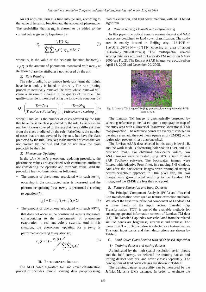
In this paper, the optical remote sensing dataset and SAR
dataset are combined to land cover classification. The study
area is mainly located in Beijing city, 116°10′E ~
116°53′E ,39°38′N~40°11′N, covering an area of about
3636km2(2020×2000pixels). The multispectral remote
sensing data was acquired by Landsat5 TM sensor on 6 May
2005(see Fig.2). The Envisat ASAR images were acquired on
April 13, 2005 and December 20, 2005.
Fig. 2. Landsat TM image of Beijing, pseudo colour composite with RGB
band 5, 4, 3.
The Landsat TM image is geometrically corrected by
selecting reference points based upon a topographic map of
the study area with a Universal Transverse Mercator (UTM)
map projection. The reference points are evenly distributed in
the study area, and the root mean square error (RMSE) of the
registration process is less than one pixel.
The Envisat ASAR data selected in this study is level 1B,
and the work mode is alternating polarization (AP), and it is
precision image. For obtaining backscatter values, two
ASAR images were calibrated using BEST (Basic Envisat
SAR Toolbox) software. The backscatter images were
filtered with Adaptive Frost filter, in a moving 5×5 window.
And after the backscatter images were resampled using a
nearest-neighbour approach to 30m pixel size, the two
images were geo-corrected referring to the Landsat TM
image, and the RMSE are less than one pixel.
The Principal Component Analysis (PCA) and Tasseled
Cap transformation were used as feature extraction methods.
We select the first three principal component of Landsat TM
as three bands of the input vector. Tasseled Cap
Transformation (TCT) is one of the available methods for
enhancing spectral information content of Landsat TM data
[11]. The Tasseled Cap index was calculated from the related
six TM bands are brightness, greenness and wetness. The
mean of PC1 with 3×3 window is selected as a texture feature.
The total input bands and their descriptions are shown by
1) Training dataset and testing dataset
As indicated by the high spatial resolution aerial photos
and the field survey, we selected the training dataset and
testing dataset with six land cover classes separately. The
The training dataset separability can be measured by the
Jeffries-Matusita (JM) distance. In order to evaluate the
International Journal of Computer and Electrical Engineering, Vol. 6, No. 2, April 2014
159
ij
iteration t,
A. Remote sensing Datasets and Preprocessing
B. Feature Extraction and Input Datasets
C. Land Cover Classification with ACO Based Algorithm
tremij
tremij
tremij
tremij
descriptions of land cover classes are shown in Table II.
Table I.

quality of training data set, the JM distances are calculated
between the pair of land cover classes. The JM distances
between the two classes are mostly>1.9, so we can conclude
that the training dataset have good separability, using it to
land cover classification is a convincing research work.
TABLE I: INPUT FEATURE VECTOR OF LAND COVER CLASSIFICATION
Input
bands
Description of land cover feature vector
Band1 PC1 (the first Principal component of Landsat TM
on May 6,2005)
Band2 PC2 (the second Principal component of Landsat
TM on May 6 , 2005)
Band3 PC3 (the third Principal component of Landsat TM
on May 6 ,2005)
Band4 ASAR1 (backscatter index image after filter of
Envisat ASAR on April 13 ,2005 )
Band5 ASAR2 (backscatter index image after filter of
Envisat ASAR on December 20, 2005)
Band6 TCT1 (brightness, Tasseled Cap Transformation
of Landsat TM on May 6,2005 )
Band7 TCT2 (greenness, Tasseled Cap Transformation of
Landsat TM on May 6, 2005 )
Band8 TCT3 (wetness, Tasseled Cap Transformation of
Landsat TM on May 6, 2005 )
Band9 Mean ( the mean texture of PC1)
TABLE II:
DESCRIPTION OF TRAINING DATASET AND TEST DATASET
2) Classification results
The ACO algorithm was used to construct classification
rules based on the selected training dataset, and the
parameters of ACO algorithm were set as follows:
Number of ants (No_of_Ants): 60
Minimum number of cases per rule (Min_Cases_ per_rule):
10
Maximum number of uncovered cases in the training
dataset (Max_Uncovered_Cases): 10
Number of rules used to test convergence of the ants
(No_Rules_Converg): 10
Number of Iterations: 1500.
The cAnt-Miner algorithm has discovered 12 ordered rules.
Since in the ACO algorithm, the ant colony can search the
best rule at each iteration time from the training data, so the
higher rank rule from the result can get the more accurate
land cover classification results than the lower rank ones.
And the input feature vectors constructing the high rank rule
also show more importance than the lower rank ones. From
the rule list, we can see that the rules include Envisat ASAR
vectors are almost at the bottom of the list, which shows that
the Envisat ASAR data is the ancillary data for the land cover
classification, and adding the SAR data always improve the
classification accuracy of that land cover class with low
separability. Using the rules, the land cover classification
obtained the best overall rank based on the classification
precision and Kappa coefficient among the four algorithms
being compared. On the other hand, it can be observed that
using the combination of multiple features can evidently help
the discrimination of bare farmland and urban land. So, using
the combined optical and SAR dataset can improve the
overall precision.
3) Classification validation and analysis
For comparison purposes, two other well known classifiers
in remote sensing data classification research field were used
in the classification experiment to evaluate the performance
of cAnt-Miner classifier. One is MLC-a probabilistic method,
the other is also most well known decision tree method
namely C4.5. We also applied the same training dataset to
train MLC classifier and C4.5 classifier, and evaluate them
using the same test dataset.
Confusion matrices of the results for cAnt-Miner,
Ant-miner, MLC and C4.5 using the same test dataset are
calculated. Comparing the confusion matrix of cAnt-Miner
with MLC, it is seen that using cAnt-Miner classifier can
improve the bare farmland and bare land greatly than using
MLC classifier, and the precision of other land cover classes
changed little. Comparing the confusion matrix of
cAnt-Miner with C4.5, it is seen that using cAnt-Miner
method can to a large extent improve the classification
precision of urban land, farmland and green land than using
C4.5 classifier. In general, using ACO classifier has great
advantages to land cover classification with combination of
the optical and the SAR dataset in comparison of using MLC
classifier with C4.5 classifier. The classification from ACO
classifier has achieved considerably higher precision than
that obtained from MLC classier and C4.5 classifier. The
overall precision obtained from cAnt-Miner classier is
95.47%, and from Ant-Miner classifier is 95.26%, they are
higher than that of MLC and C4.5. And from data mining
point of view to comparison, the rules that ACO algorithm
has found are much simpler than that found by C4.5. The
cAnt-Miner can slightly improve the precision and can
construct simpler rules comparing with the Ant-Miner. The
number of rules by cAnt-Miner is 12, but the decision tree
that constructed by C4.5 are very complex, the tree have 562
leaves, and the size of tree is 593. In summary, using the
cAnt-Miner classier can got high classification precision and
also well simplifies the classification rule set.
IV. CONCLUSION AND DISCUSSION
In this paper, the ACO algorithms has been presented for
land cover classification, and also the paper demonstrates the
usefulness of combined using of the Landsat TM and the
Envisat ASAR data covering Beijing area for land cover
Class
number
Type description Training
dataset
Test
dataset
1 Bare
farmland
farmland covered
with soil
804 786
2 Bare land airports, squares,
other land with
high reflectivity
881 360
3 Urban
land
buildings, roads 2041 1150
4 Farmland farmland covered
with crops
1230 549
5 Green
land
trees, grass 1013 504
6 Water reservoirs, lakes,
rivers
826 407
total 6795 3756
International Journal of Computer and Electrical Engineering, Vol. 6, No. 2, April 2014
160
HE T
map was produced (see Fig. 3).
As can be observed in Table III and Table IV, cAnt-Miner

classification. The ACO classifier can combine the multiple
source spatial datasets to land cover classification, and it can
constructed the ordered classification rules that will select the
best features extracted from optical and SAR dataset . So the
ACO can help improving the discrimination ability among
the different land cover classes. So from the experimental
results, it is observed that the ACO outperforms the other two
algorithms, MLC and C4.5. And the cAnt-Miner classifier
can construct much simpler rules and higher accuracy.
In summary, from the experimental observations it is seen
that cAnt-Miner classifier is an effective approach for
automatic land cover map generation from combining optical
and radar remotely sensed images.
Fig. 3. Land cover classification map of ACO
TABLE III: CONFUSION MATRIX FOR THE CLASSIFICATION RESULTS OF ACO USING COMBINATION OF TM AND ASAR DATASET
Class Bare farmland Bare land Urban land Farmland Green land Water User precision (%)
Bare farmland 739 55 3 0 1 0 92.61
Bare land 47 295 14 0 0 1 82.63
Urban land 0 10 1128 0 1 16 97.66
Farmland 0 0 0 534 2 0 99.63
Green land 0 0 0 15 500 0 96.15
Water 0 0 0 0 0 390 100.00
Produced precision (%) 94.02 81.94 98.09 97.27 99.21 95.82
TABLE IV: COMPARISON OF CLASSIFICATION OBTAINED FROM ACO, MLC AND C4.5
classifier Overall precision (%) Kappa coefficient Percent of misclassification (%) Simplicity of rule sets
cAnt-Miner Ant-Miner
95.47 95.26
0.9435 0.9410
4.53 4.74
Number of rules:12 Number of rules:31
C4.5 92.92 0.9119 7.08 Number of leaves:562 Size of tree:593
MLC 90.31 0.8797 9.69 —
ACKNOWLEDGMENT
The authors thank for the cAnt-Miner software shared by
Fernando E. Otero.
REFERENCES
[1] G. M. Foody, ―Status of land cover classification accuracy assessment ,‖
Remote Sensing of Environment, vol. 80, pp.185-201, 2002.
[2] D. Lu and Q. Weng, ―A study of image classification methods and techniques for improving classification performances,‖International
Journal of Remote Sensing, vol. 28, pp. 824-849, 2007. [3] T. Kuplich, C. Freitas, and J. Soares, ―The study of ERS-1 and Landsat
TM synergism for land use classification,‖ International Journal of
Remote Sensing, vol. 21, pp. 2101-2111, 2000. [4] M. Dorigo and L. M. Gambardella, ―Ant colony system: A cooperative
learning approach to the traveling salesman problem,‖ IEEE Trans.
Evol. Comput., vol. 1, pp. 53-66, Apr.1997. [5] M. Dorigo, ―Optimization, learning and natural algorithms,‖ Ph.D.
dissertation, Dept. Electron., Politecnico di Milano, Milan, Italy, 1992.
[6] M. Dorigo, V. Maniezzo, and A. Colorni, ―Ant system: Optimization by a colony of cooperating agents,‖ IEEE Trans. Syst., Man, Cybern.
B,Cybern., vol. 26, pp. 29-41, Feb.1996.
[7] X. Liu, X. Li, L. Liu, J. He and B. Ai, ―An innovative method to classify remote-sensing images using Ant colony optimization,‖ IEEE
Transactions on Geoscience and Remote Sensing, vol. 46, pp.
4198-4208, 2008. [8] R. Parpinelli, H. S. Lopes, and A. A. Freitas, ―Data mining with an ant
colony optimization algorithm,‖ IEEE Transactions on Evolutionary
Computation, vol. 6, pp. 321-332, 2002. [9] F. Otero, A. Freitas, and C. Johnson, ―CAnt-Miner: an ant colony
classification algorithm to cope with continuous attributes,‖ in Proc.
the 6th International Workshop on Ant Colony Optimization and Swarm Intelligence, Belgium, 2008, Springer, pp. 48-59.
[10] U. Fayyad and K. Irani, ―Multi-interval discretization of
continuous-valued attributes for classification learning,‖ in Proc. The Thirteenth International Joint Conference on Artifical Inteligence, San
Mateo, USA, 1993, pp.1022–1027.
[11] E. Crist, and R. Cicone, ―Application of the tasseled cap concept to simulated thematic mapper data,‖ Photogrammetric Engineering and
Remote Sensing, vol. 50, pp. 343-352, 1984.
Qin Dai received the Ph.D. degree in the institute of
remote sensing application (IRSA), Chinese academy
of sciences (CAS). She is currently an associate
professor of Institute of Remote Sensing and Digital Earth (RADI), CAS. Her research interests include
machine learning, artificial intelligent methodologies
applied to remote sensing image classification, image retrieval, and image change detection. She is a referee
for several international journals.
Shibing Liu is an associate professor of Institute of
Remote Sensing and Digital Earth (RADI), CAS. His research interests include spatial database and spatial
data services.
Jin Yang is an associate professor of Institute of
Remote Sensing and Digital Earth (RADI), CAS. His
research interests include remote sensing image retrieval and spatial data services.
Zhaoming Zhang
received his Ph.D.
degree in
Cartography and Geographical Information System in
institute of remote sensing applications, CAS
(University of Chinese Academy of Sciences). His
current research interests are land surface parameters
retrieval and remote sensing applications.
Bare farmland
Urban land
Bare land
Farm land
Green land
Water
International Journal of Computer and Electrical Engineering, Vol. 6, No. 2, April 2014
161