A Model for Urban Re-Vitalization and Upgrading Lucia Ruano_Guatemala_A model for …SWOT -...
30
A Model for Urban Re-Vitalization and Upgrading La Reformita, zone 12, Guatemala City Integrated Urban Planning - IUP Sweden - Mozambique 2009 Author: Arch. MFA Ana Lucia Ruano Robles
Transcript of A Model for Urban Re-Vitalization and Upgrading Lucia Ruano_Guatemala_A model for …SWOT -...

A Model for Urban Re-Vitalization and UpgradingLa Reformita, zone 12, Guatemala City
Integrated Urban Planning - IUPSweden - Mozambique
2009
Author: Arch. MFA Ana Lucia Ruano Robles

INDEX
Introduction 3Background
Universe 4
Social Value and Identity 4
Urban History 5
Urban Development 6
Urban Challenges 7
Description of the Pilot Project Project Objective 9
Target Group 9
Stakeholder Analysis 10
Planning Process - Organization and Administration 11
Present Situation Analysis 12
SWOT - Opportunities and Develpment Potential 15
Formulation of development objectives for the project area 15
Proposal for Re-Vitalization and Upgrading of “La Reformita”Alternative Development Scenarios 20
Proposed Develpment Plan for Re-vitalizing and Upgrading the area 23
Implementation and Investment AlternativesImplementation 25
Investment Alternatives 27
Conclusions and Recommendations 29References 30
With 234 years of existence Guatemala City has a lot of history and it has suffered great changes throughout the
centuries, not only due to an uncontrolled growth but cultural and social change as well. For the visitor it is a new
experience getting to Guatemala City, because the first impression will be that is a chaotic city, cars buses, trucks, running
pedestrians, street vendors, etc.; all of them sharing the same space, in a disorderly way. The traffic is intense from early
morning to late in the afternoon, being that a lot of people come to work from outside the city limits. You will see every
kind of movement, people working, trucks just passing by to get their goods to another part of the country and people
with goods to sell in the market.
As far as the city and city limits are concerned, it has become practically impossible to determine where the actual
city starts, since the rapid growth of the city has reached what used to be the outer villages and merged into one. In
recent years, from 2002 to date, the urban traffic problems to the entrances to the city have increased (within the central
district), the cost of fuel has been increasing and the growing inflation has been observed. This is coupled with the lack
of necessary and proper infrastructure and has provoked that certain areas of the city gradually lose its population density.
Residential areas had become centers for commercial activities during the day and left deserted at night allowing illegal
activities during this time, increasing in this way the violence. This also generates among other things urban disorder,
insecure areas, uncontrolled urban growth and poor living conditions.
These conditions create the opportunity for the preparation of a “Proposal for upgrading and re-vitalization” of
several urban sectors of Guatemala City. In this case we will focus on a determined area of zone 12 and propose a
development model of it. The basis for this redesign are the proximity and the access to public transport, the existence
of basic services (drainages, drinking water, electricity), ease of providing services to take the concentration of population
in the area, a mixture of size solutions for housing and economic segments. It will in the end be a mixed use of commercial,
office and housing (a unitary model for the development for the area)
The project is aimed at helping revitalize an area that is actually abandoned at nights. It used to be a housing
area, but due the rapid growth of the city it turned into a mixed use area. This would not have been bad if it has if it has
done so in an orderly way and following a plan, but it has been rather disorderly leading of the reuse of buildings designed
for a specific purpose and turned into something else. This carries along a lot of different issues that can be identified with
some research to bring a solution from the core.
It will be a benefit for the community in general, not only will it be good for the few residents that still there, but It
will bring work, improved infrastructure, social and educational facilities. The main goal is to generate a sustainable solution
that would be not just a pretty architectural solution but an integral plan to improve the quality of life of the residents and
the environmental conditions in the surroundingsFigure 2:Guatemalas City Accelerated GrowthSource: POT Plan
Figure 1:Guatemala City Valley
INTRODUCTION
A Model for Urban Re-Vitalization and Upgrading - La Reformita, zone 12,Guatemala City
3
Ana Lucia Ruano Robles
4
BACKGROUND
UniversalThe Republic of Guatemala is located in the
northern part of the Central American isthmus,bordering on the north and west with the Republic ofMexico, on the South with the Pacific Ocean and onthe east by the Atlantic Ocean and the Republics ofBelize, Honduras and El Salvador.
Its territorial extension is approximately 108,889square kilometers. The country has two seasons ayear, winter and summer, it’s climate is variedaccording to its topography and therefore it can gofrom warm to mild and very cold. It is divided into 22departments, which are grouped in 8 regions.
Social Value and Identity:The Republic of Guatemala is characterized by
its beliefs in supernatural beings, the stories and oldhabits, which are carried solemnly in various rituals.These are observed mostly in the rural provinces andmunicipalities.
The main parties and fairs are addressed to: theSaints, All Souls, Lent, and Easter with its traditionalprocessions and carpets, the month of Our Lady ofthe Rosary, among others. Folk dances also make anappearance in some celebrations. Among them, theMoors, Christians, El Torito, La Conquista, Los Diablos,Costeños, treats, The Fierce, 12 Pairs, and others.
Guatemala in figures
Population11.23 million (2002)
Urban/rural population rate (%)46.1/53.9 (2002)
Total area108,889 km2 (aprox)
LanguagesSpanish (official)Quihe, Mam, Kekchi and Cakchiquel, togetherwith 60 - 70 other Mayan languages
Ethnic groups (2002)Indigenous ~ 41.03%Non Indigenous ~ 58.97%
Day average temperatureGuatemala City; 21o C July17o C January
SeasonsDry season (October - May)Rainy season (June - September)
PrecipitationRange from 1000 - 1500 mm
Sun lightning180 sun/hours, indicates a medium level of solarexposure. In the Guatemalan Region the sun is in inthe Zenit from April 29th to April 30th and fromAugust 14th to August 15th
Relative Humidity75%
WindIn the country the wind direction is N - E to S - O,during the months of February, March and OctoberInverse flutuations are registered.Max speed is 50 to 60 Kms/h
Sources:
Instituto Nacional de Estadística (INE)
INSIVUMEH
Figure 3: Universe of InvestigationSource: Google Earth, Atlas Guatemala
El Progreso
Jalapa
Santa. Rosa
Escuintla
Sacatepequez
Chimaltenango
Baja Verapaz

5
Guatemala City has its own unique habits andidentity. This is a nucleus of different kind of values interms of cultural heritage, urban, social andeconomical values, which have been evolving throughthe history of the city and its growth.
The people that moved from the last city, “theold city” brought along with them their own valuesand customs. Thus the new city inherited not onlysocial values but urban and architectural ones as well. Proof of this is found in still existing oral traditions,legends, gastronomy and buildings with particularcharacteristics.
The main “fiesta” for the Capital City is fromAugust 8th to 16th, the main date being the 15th, thedate on which the Catholic Church celebrates itspatron saint, the Virgin of the Assumption.
Urban HIstoryThe foundation of “Guatemala City” has an
interesting long history, due to the topography of thecountry, it was moved 3 times before settling downwhere is now known as “Guatemala de la AsuncionCity” at the end of 1775. At that time the “old city”was destroyed by an earthquake and therefore theurban planning and the urban characteristics evolvedwith each change of location. The new site waschosen because it had access to water, providedhealthful conditions and security from earthquakes,which later proved to not be as secure as first assumed.
The official date for the foundation of the newcapital city is January 2nd 1776, founded during thelast decades of the colonial times, then used the“Spanish model” which was established by the ordersof Felipe II in 1573. Like every colonial design it hadbasic characteristics (See figure 6):
• Landscape divided by a main square in the center• Streets divided into blocks• One storey houses with a central yard in them
The original plan for the city included twohundred blocks, organized around Plaza Mayor, thecentral and ceremonial square. The city grew slowlyand the new housing areas were mainly located tothe northwest of the city. One of the firstneighborhoods that still exists to the date is known as“La Parroquia”. After just a couple of years of settlingthe new city there was already 11,000 inhabitants(Lagenberg 1981:387/Gaceta de Guatemala). Thewater shortage was already beginning be evidentand two large aqueducts were built. It remained acolonial city for a century. When the liberal periodstarted the urban structure transformed from colonialto modern. As a result of the expanding economyand investments in infrastructure and social programs;that ranged from schools, public spaces all the wayto railroads and electricity, this development periodlasted from 1871 through 1918 when a series ofearthquakes hit the city.
Reconstruction begun after this and as a resultmany 19th century heritage buildings were replaced
Figure 4:“Semana Santa” - Easter carpets
Figure 5:Folklore - “Los Moros”
A Model for Urban Re-Vitalization and Upgrading - La Reformita, zone 12, Guatemala City

Ana Lucia Ruano Robles
6
with new ones. By the 1940’s there was a modernscene going on, and the city started to grow in anaccelerated manner.
The city had now begun to sprawl in alldirections. Soon bridges across the ravines wereconstructed to connect the centre with the rest ofthe valley and the main roads developed as the axisof the growing city. This also led to segregation andmigration as the most prominent families moved fromthe city centre to the new suburbs, while the peoplefrom the departments started to move the city. All ofthis combined resulted in the deterioration of thecentre and the shortage of housing for the newhabitants. Another earthquake hit in 1976 whichdestroyed a lot of buildings and caused a doublingthe amount of housing needed. People were forcedto form informal settlements. It was realized that socialhousing projects were needed, which was rare in thecountry and mostly it was financed with internationalhelp.
In the 1980’s the economic recession hit thecounty and the social housing was not enough tosatisfy the demand. People started to invade landwherever it could be found, from suitable land to theravines. The government evicted these people fromrisk areas and gave them a space in the periphery ofthe city and outside the metropolitan areas. Thenthe invasion was uncontrollable and instead ofreducing the numbers of invaders, they grew.
Since previously invaded land was invadedagain the squatters multiplied. In an attempt to findsolutions some invaded areas were consolidated and
legalized, and consequently there are lots of thempresently.
Urban DevelopmentThe trend described above has continued and
the city is still growing in every direction possible.Development takes place even in ravines and otherunsuitable areas through private developer, landinvasion and creating new squatter areas. This situationled to the creation of a municipal entity with the taskto properly consider urban planning and development. The entity is known as “Metropolis 2010” and it worksalong with a consulting Dutch firm DHV. There hasbeen a struggle between the municipality and thecentral government concerning urban planning. Sincethe government can intervene at administrative levels,it is sometimes difficult to reach common ground anddevelop urban proposals.
Also there is no common building code and nonorms for land use and development applicable tothe whole country. Each municipality is responsiblefor its own urban development and each one putsup its own criteria and regulations for doing so. Theyare not concerned with proper sustainabledevelopment and housing projects, in the absenceof central government guidance the commonapproach is provided and covered mainly byFOGUAVI (autonomous governmental department),the pr ivate sector and non-governmentalorganizations. They play an important role forupgrading and development of low-income housing.
Figure 6:Design of “The New City of Guatemala, 1776”by Luis Díez de Navarro, 1776:
This Project was based on the square design,which consists in a “Central Square” or parksurrounded by Governmental buildings and theCathedral; on the four cardinal points other foursquare are developed with their respectivechurches.
Figure 7:Palacio Nacional de la Cultura(City Hall)
7
Metropolis 2010 is the department for planningand development in Guatemala City. They havecreated a plan called by the same name. Basicallythis plan intends to improve the city with high-densitydevelopment in the centre and sub-centers. A roadsystem consisting of new ring roads with bridges overthe ravines and existing diagonal roads for connectingnew and existing sub-centers forms part of theproposals.
The public transportation system is based on asemi-circular ring road called Anillo Periférico (Spanishfor ring road) that surrounds the city centre on thewest side. The aim is to develop the other half of thecircle to complete the ring road.
Since 2007 a new a bus system called“Transmetro” has been implemented, which has itsown lanes in the streets. The principle for this systemis to avoid mixing with the ordinary city traffic andgive proper transport services to the people. Thebuses have fixed stops at certain distances and theyare located near areas of heavy pedestrian activity. The bus route transits over the main axis of the city.Currently there is only one route, but there are plansto create new routes to provide public transport forall parts of the city.
The latest effort that is being implemented is thenew “Plan de Ordenamiento Territorial – POT” (standsfor Land Management Plan). The main objective ofthis plan is to give guidelines for the new urbanplanning and some guidance for the accommodationof the existing areas, so they can be integrated to
the new scheme. This plan intends to classify the typeof areas, buildings and land use within the capitalcity, so that the rapid growth that is happening canbe in some way controlled and well managed.
The vision of the municipality for the POT is thatit will help simplify the existing rules, with the aim togive more clarity of information for everyone interestedin developing in a certain area (investors, residents,and authorities) and provide quality of life mainly forthe residents.
It is based on the categorization of the territoryin general areas ranging from rural to urban, takinginto account the supply of transport to determine theintensities of construction and reducing it in areas thatare environmentally valuable or where high risk isnotable. The POT standardizes administrativeprocedures that will occur as a result of interventionsat a certain point in the territory, i.e. fractionalizationand project initiatives or change in land use.
Urban Challenges Spatial segregation of the population,
uncontrolled distribution in land use and urban sprawlhas produced several negative effects. It has beenobserved that there is increasing costs of public servicesand as a consequence there has been an increasingreliance on the provision of services by the privatesector (wells, treatment plants, private means oftransport such as cars, etc).
Located on the central plateau, is positioned
as the largest city in Central America
maintains privilege since its foundation, as
it was the center of the General Captaincy
of Guatemala, which extended from
Chiapas and Soconusco to Costa Rica.
Guatemala City is the largest urban
agglomeration and also the political, social,
cultural and economic centre of the country.
It is the country’s node of communication
and it handles almost half of the capital
invested in it.
A Model for Urban Re-Vitalization and Upgrading - La Reformita, zone 12, Guatemala City

Ana Lucia Ruano Robles
8
The actual urban population growth rateaccording to UNICEF is 3.6% per year, which is verysimilar to the urban geographic expansion. This hasresulted in a horizontal growth, which leads to wrongfuluse of sensitive areas and risk areas. There is a lackof municipal land to satisfy the increasing housingdemand resulting in squatters. Since the space forgrowth within the city limits is not possible anymore,one of the solutions for resolving this issue is to growin a vertical manner, providing good quality of housingfor the people that are inevitable living in the city.This situation and the persistent development issuesprovide a good opportunity for implementing a newurban development model to guive guidelines for re– vitalizing urban areas.
In the analysis other priorities that had beenidentified are as Follows:
• Sprawl• High cost of living• Environmental management• Public transport• Primary road system, among others
The main problem to be faced in the near futureis the increasing population living in this territory andits surroundings. The city limits have been reached insome of its municipalities and this has negativeimplications from the environmental, economic andsocial perspective. The social concerns will requirethat efforts are made to provide quality services andhousing options, health education, and equitableaccess to development.
Figure 8:Guatemalas City Zonification

9
DESCRIPTION OF THE PILOTMODELProject Objective
The intention is to provide a model to be usedand implemented in Guatemala City and in otherurban areas that have similar characteristics and aresuitable for re-vitalization, to exemplify this the pilotarea is a sector of zone 12 in Guatemala City. Thefollowing items should be used as a guideline and beadapted to the area that is going to be re-vitalized.
The bases for the redesign are the proximity andthe access of public transport, the existence of basicservices such as drainages, water, electricity, and thethe existing educational facilities. These existentfacilities will permit a planned densification of thearea. Resulting in a well planned mixed area, includingcommerce, office spaces and housing areas, keepingin mind the different economic segments that live inthe area, resulting in a unitary model of development.
The population growth in Guatemala City hasreflected the political, economical and social eventsin it. The Guatemalan Municipality has initiated arecovery plan for the city and for some sectors of it.This plan implies considering basic services andinfrastructure systems, such as public transport andterritorial regulation plan (POT) that has already beenapproved by the government. The plan will alsoprovide benefits so that a significant share of thepopulation can be returned to the city of Guatemalain the next 15 years, generating self-sustaining urbancenters within the city limits and improve access to
basic services for all.
The project is aiming at helping revitalize anarea that is actually abandoned at nights. The areaused to be a housing area but due the rapid citygrowth it turned into a mixed use area. This wouldnot be bad if it had been done in an orderly way andfollowing a plan, but it has been rather disorderlyleading of the reuse of buildings intended for residentialuse into something else. This carries along a lot ofdifferent issues that can be identified with someresearch to bring a solution from the core.
Target GroupAccording to INE1 Guatemala’s current
population is of 11,237,196 inhabitants scattered in its22 departments. 22.62% of this grand total lives inGuatemala City area, which is about 2,472,184 people(see figure 9).
The specific population that will benefit fromthe project are the inhabitants of an specific area ofzone 12 in Guatemala City called “La Reformita”,located on the south side of the city. This particulararea presents a great opportunity for developing amodel for revitalization of existing urban areas thatare being abandoned. This area represents a merely1.71% of the total Guatemala City’s population (seefigure 10).
It will be a benefit for the community in generalmeaning not only will it be good for the few residents
1 INE (Instituto Nacional de Estadistica) - The
National Department for Statistics
Figure 9:Percentage of Guatemala City InhabitantsSource: INE 2002
Figure 10:Percentage of Zone 12 InhabitantsSource: INE 2002
A Model for Urban Re-Vitalization and Upgrading - La Reformita, zone 12, Guatemala City
Ana Lucia Ruano Robles
10
that still live there, but it will bring work, infrastructureservices, social services and educational facilities tothe area. The main goal is to generate a sustainablesolution that would provide not just pretty architecturalsolutions but will be an integral plan to improve thequality of life for the residents and also improvementsin surrounding areas.
Stakeholder AnalysisStakeholders are considered to be as anyone,
who is involved and will have a saying during theplanning process, this does not mean that they willbe involved in every stage of the process.
Since the project is intended to be a MasterPlan for a big area, the process needs thecollaboration with several stakeholders in order toachieve the targets. The group of stakeholders willinclude but will not be limited to the municipalauthorities, Multiproyectos (the company that isdeveloping the master plan), the community (workers,local population, and traffic of different sources),outside investors (other interested companies) and ifpossible international donors.
They have been divided according to size orthe representation and the type of activities into fourgroups:
• Authorities and investors: These are theorganizations or people who will lead the projectin some manner, the ones that will bring theresources and the experience and will be involved
to develop the planoMunicipal AuthoritiesoMultiproyectosoPrivate Investorso International Aid and NGO’s
• Personal Interest: These are people that actuallywill benefit from the implementation of the plan.They are the core for the investigation regardingissues, assets and needs of the area
oCommunityoMarket Inhabitantso Small home businessoWorkers and Passers by
• Commercial Relationship: There are manyeconomic interests at play so these persons andorganizations that have a very important role toplay in the planning
o Industry SectoroBusiness on the main streetsoBar owners
• Students and University: This is one of the strongestpoints in the plan, this is an anchor for the revitalization problem, because the inclusion of thesegroups in the planning and eventually thebeneficiaries of the implementation of the plan willmake the area alive. The revitalization will alsosolve the housing issues for students that comefrom outside the city
oUniversityo Students who lives in the city
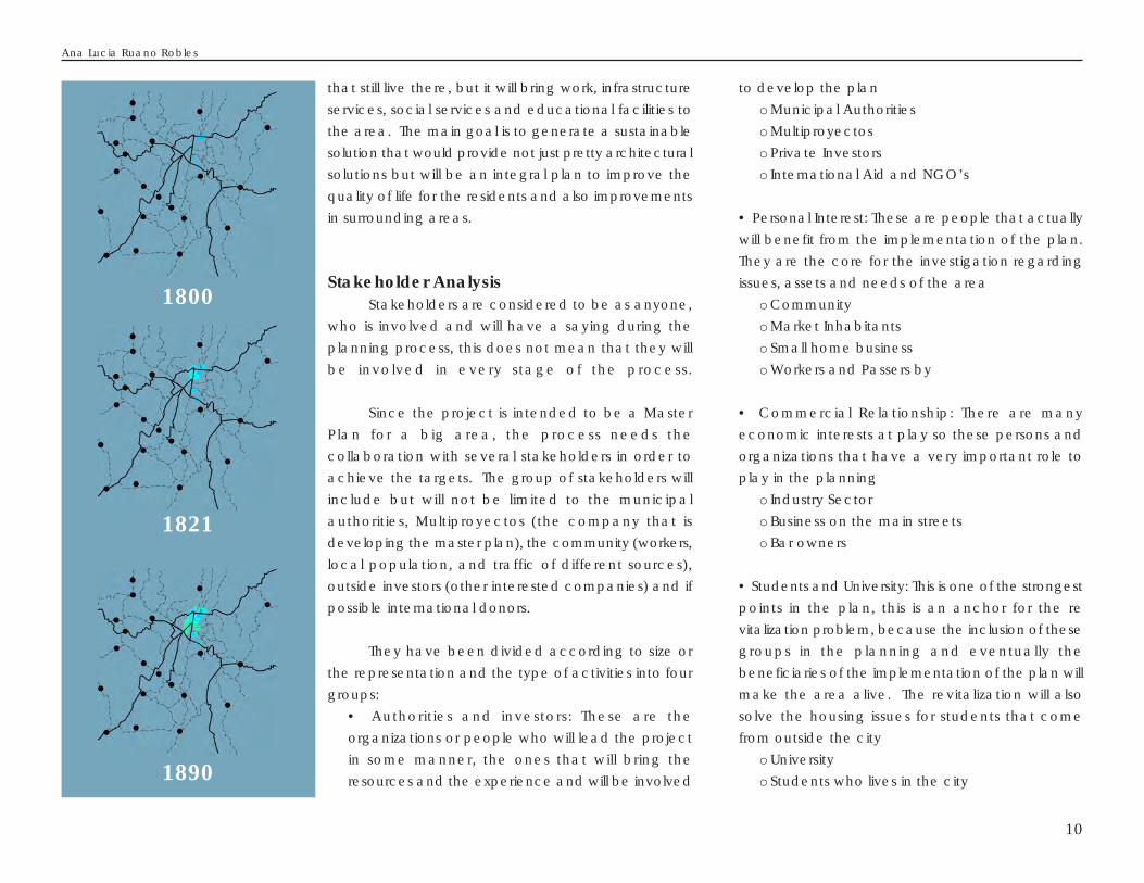
1800
1821
1890

11
o Students who will come from other parts ofthe country and need a place to live in while studying
Planning Process - Organization andAdministration
The project is proposed to be carried out ascollaboration between the municipal authorities andprivate investors, being coordinated by Multiproyectos. The goal is to propose a masterplan for the reordering and redesignof the areas in the sector (land usemaster plan) and a proposedmethodology for similar futureprojects in other settlements. On amuch smaller scale, it is the intentionto develop a igniting project in thearea to get the interest of differentprivate investors to becomeinvolved and develop the areaaccording to the proposed plan.
The administration of theplanning project should considerthe following entities (see figure 11):
• Steering committee - shouldfunction as a sounding board forideas; provide guide lines andrecommendations as required. I t
should include representatives of the investors andthe authorities involved.
• The core planning team - responsible fordeveloping the actual plan for implementationand all the documentation required for this
• Planning support - will bring input from expertise,they will function as advisors and it will have a
1940
1950
1960Figure 11:The Planning Organization
A Model for Urban Re-Vitalization and Upgrading - La Reformita, zone 12, Guatemala City

Ana Lucia Ruano Robles
12
temporary participation and set-up.
• Reference Group(s) - consisting of important stakeholderorganisations in the area, investors and municipality representatives. They will bring forward the inside vision of the area and their needs,for this purpose there will be a need for group meetings to discussthe issues that are presented.
• Public participation process - This will help to know communicatewith and meet the public and local CBOs at regular interval forexchange of ideas, analysis of problems and potentials, and capacitybuilding.
For the planning process to succeed is important to have as acomplement a working plan and a time table for each of the phasesand for the activities necessary for implementing the proposal. Everyoneinvolved in the process will have to be bounded to the schedules fortimes, targets and objectives are met. This will be managed by the coreteam and each stakeholder that is involved will have to committhemselves to it according to their responsibilities.
Present Situation AnalysisThe area that is being analyzed is a mixed use area, that stared
as a housing project but then rapidly grew with informal business to helpthe economic situation of each household, this lead to the first mixedactivities (living/working) permitting with this that everyone started tobring home their work.
The constructions were used for whatever needs and some of theproperties have simple fences or some kind of non-formal walls andhave poor provisions for services normally required to put up a businesssuch as a mechanic shop or wheel repair shops .
1970
1980
2000
2020
Figure 12:Urban Development Guatemala CitySource: POT Plan

13
The area is being situated between 2 majorcirculation arteries and the land along these roadshas increased in value not to mention the proliferationof business. Bit by bit people started to move out duethe noise and all the unknown people that came intothe area, ending up with a really busy area duringday but silent almost abandoned at night. This situationwas worsened by the levels of delinquency and lackof good lightning along the streets.
The following describes the situation analysisfrom different perspectives:
• Regional Settingo Guatemala City is divided in 20 zones; zone12 is located at the south of the city centre. Itis formed by various neighborhoods, amongthem is “La Reformita” which will be the onearea chosen for this studyo This is an urban setting project, located inthe city, between 2 major streets. It gives thelocation easy access and connectivity to therest of the city, and has the advantage to benear the San Carlos University (nationaluniversity).
• Architecture and constructiono It has no defined architectural style, sinceit has been growing as the years have gone by,there can be found many constructiontechniques, some formal housing and somerather informal and insecure buildings.o Materials range from masonry, wooden
constructions and some new ones made out ofconcrete. The less safe constructions are madeout of waste and rubbish materials like usedgalvanized sheets, wood or even cardboard
• Demographyo Percentage of female population is higherthan male populationo Most households are overcrowded, consideringthat they do have formal buildings along theareao Majority of inhabitants are economicallyactive, situated between the ages of 15 to 64. And men are more likely to have works.o The area shows that the inhabitants have atleast primary school educationo For more details see “Zone 12” in figuresframe
• Land Use and Existing Regulationso Land use as has been mentioned is diverseincluding but not limited to housing, informalcommerce, street commerce, bars, schooling,industry, arranged in a disorderly way.o There is a new regulation for land use beingimplemented in Guatemala, mainly aiming atnew developments or recuperation of certainareas. This will be applied to this project (POT)and based on this new regulation proposalscan be developed.
• Transporto The area has access to the only massive
Zone 12 in figures
Population and HouseholdsPopulationMale/Female (%) HouseholdsPersons/household
Age (%)0 - 1415 - 6465 -
Education (%)NonePre Primary SchoolPrimary SchoolSecondary SchoolHigher Studies
Housing Types (%)Formal BuildingsPrivate ApartmetsRental Room/small aptImporvised
Instalations (%)WaterDrainageElectricity
Labour Force (%)MaleFemale
Sources:
Inst i tuto Nacional de Estadíst ica ( INE)
4339847/53
7508 5.8
26677
51
333218
714
241
343135
2519
A Model for Urban Re-Vitalization and Upgrading - La Reformita, zone 12, Guatemala City
Ana Lucia Ruano Robles
14
means of transport in Guatemala: buses andthe new improved Transmetroo There’s no internal transport service, tocommunicate both of the main streets and thearea within
• Economic Activitieso This is a mixed use area, and it is an economicfocal point for the city, the variation in types ofbusiness includes a wide range, that goes fromlittle house business to private conglomerates.o Storage facilities are easily found in the area,lately this type of condominiums has beengrowing along “Calzada Atanasio Tzul” whichis a less important s t reet regardingcommunication within the city, but gettingincreasing commercial value every dayo At the moment there are clearly someactivities identified like informal housecommerce (tiendas), the public market, bars,industry area and formal commerce
• Services (social and commercial)o The area has two public primary schools,a public market, one public health care center,the university and churches. One of the nationalhospitals is near the area so it can be reachedeasily.o Regarding commercial matters it is easy tofind practically anything you look for, besides the
public market there are also small stores
incorporated in the houses (called tiendas), home
bakeries, and a big supermarket on the main street
• Infrastructure and urban equipment
o In order to create a better area the existing
infrastructure has to be analyzed to determine if
it needs improvement and what is missing
o Infrastructure in the area is already there, it
has basic services such as water, sewage system
and electricity. However there are some tenants
that still use old drainages like septic pits or drainage
outlets into ditches; instead of connecting their
properties to the main sewage line. It also has
paved st reets and phone l ine access
o We can find some urban equipment such as:
§ Trashcans
§ Phone booths (prepaid card ones)
§ Advertising fences
§ Street lighting
§ Traffic lights (only along the main streets)
• Land Ownership
o Land ownership in most parts of the area is
private and rented to third parties if not used by
the owner. Some areas remain as public domain
and the municipal authorities are the ones that
manage and own such land.
• Open space/greening
o None! Just a little basketball court and a couple
of trees on the sidewalks, no proper green area

15
SWOT - Opportunities and DevelopmentPotential
For a better understanding is just a matter or pros
and cons. The SWOT analysis has to be developed
between the Steering Committee and the community
and this will be best achieved through workshops and
interviews. For the model and for getting any process
started the developing company will analyze the area
and decide if it is suitable for re-vitalization.
Strengths and Development Potential
• Existing infrastructure (meaning less investment)
• Important access streets around the whole area
• National University Campus
• Commerce and economic activity already
established
• Great potential for improvement of living/working
conditions for the inhabitants
• Great potential for attracting people to move back
to the area (since now is just active by days and the
inhabitants had moved away
• Significant potential for new development niche,
to offer different accessible housing units
• Implementing IUP
Weaknesses
• Lack of capacitating on IUP
• Traffic reordering (are we capable of covering the
demand?)
• Lack of integrity among the construction techniques
and materials available (economic issue)
• Abandonment of the buildings during night hours
• Deterioration of the urban environment due to the
lack of maintenance for the buildings, public wiring,
transportation and delinquency.
• Poor safety and security
Formulation of development objectives forthe project area
From all was has been observed before the
following questions can be put forward: How can an
urban and architectural solution to the problem of
disintegration between living, working and public spaces
be found? How to improve the urban environment of
“La Reformita”, through an urban and architectural
proposal? How to give a new use to the already existing
infrastructure? What characteristics should be considered
as valuable to develop and later to be implemented
through a master plan for the area?
HypothesisTo improve the urban environment of “La
Reformita”, it is necessary to propose a methodological
model for the urban re-vitalization plan. The model will
give guidelines and a general view of what is needed
to achieve the goal. The outcome of the plan will be
restored interest in the area and improved living
environment to its inhabitants.
There is the need to re order the activities and
restructure the land use in the area, and provide some
public spaces for the people. A good integrated urban
such improvements to the benefit for the inhabitants. It
will merge human needs for living, working, resting and
basic services areas.
For the full proposal to be authorized for
developing and implementation, first a
general proposal has to be given to the
municipality, for them to understant what is
it that wants to be achieved. And only after
approval has been given it can be
developed fully (develop in detail each of
the phases)
A Model for Urban Re-Vitalization and Upgrading - La Reformita, zone 12, Guatemala City

Ana Lucia Ruano Robles
16
ObjectivesGeneral
To conduct a comprehensive development area
planning, according to a pilot model which will be “La
Reformita” area and that can be easily used in other
areas, i.e. a plan that can be a reflective mirror anywhere
either in the city or in the interior of the republic. This
master plan aims to restructure areas that are already
established and share similar characterist ics.
SpecificAnalyze a specific area in Guatemala City (zone
12), its present situation and infrastructure in order to
propose a plan for re-vitalization.
Develop an urban master plan to propose land use
restructuring based on the actual POT regulations and
the needs observed in the working area. This will include
the igniting projects needed for both the public and
private sector to gain interest in the area.
Develop a document that can be used both as
a guideline for future projects and a source of information
for students and professionals involved in this area of
urban planning and architecture
MethodFor this kind of project it is necessary to consult with
professionals related in the urban field. It is also required
to do a study of the target group (who the plan will serve).
Collect graphic material (pictures, blueprints and physical
visit) so the area can be analyzed. Based on the analysis
of the compiled information and with “La Reformita” as
a planning example the urban planning proposal for the
problem will be presented.
It is also important to consider the other stakeholders
which will contribute with this model, such as the
community involved since they will be the ones that will
tell us the realitly of where they live. With this important
information then the planners can come up with an
integrated urban proposal for the improvement of the
area.

17
Figure 14:Calzada Roosevelt - Main Street
Figure 15:Avenida Petapa - Secondary Street
Figure 16:Calzada Aguilar Batres - Main Street
Figure 13:Guatemala City Limits
Calzada Roosevelt
CalzadaAguilar Batres
Avenida Petapa
Boulevard Liberacion
Avenida Bolivar
Anillo Periferico
CITY MAP N
Boulevard Los Proceres
Main Street (Access to Guatemala City, High Traffic)
Secondary Street (Conects the rest of the City to Main Street, High Traffic)
City Limit
A Model for Urban Re-Vitalization and Upgrading - La Reformita, zone 12, Guatemala City
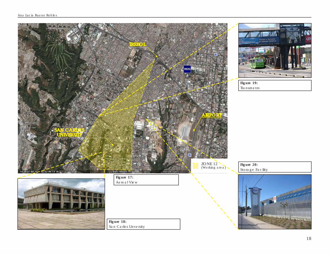
Figure 19:Transmetro
Figure 18:San Carlos Unversity
AIRPORT
SAN CARLOSUNIVERSITY
TREBOL
ZONE 12(Working area)
Figure 17:Aereal View
Figure 20:Storage Facility
Ana Lucia Ruano Robles
18
19
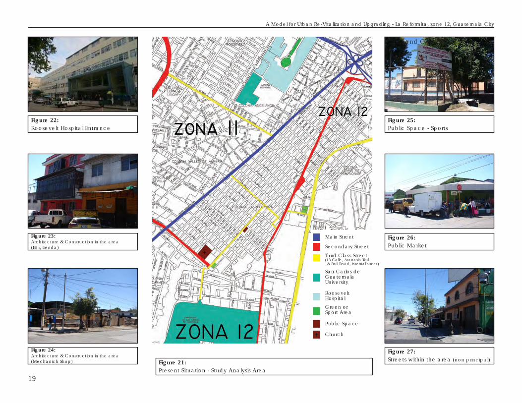
Figure 21:Present Situation - Study Analysis Area
Figure 24:Architecture & Construction in the area(Mechanich Shop)
Figure 23:Architecture & Construction in the area(Bar, tienda)
Figure 22:Roosevelt Hospital Entrance
Figure 27:Streets within the area (non principal)
Figure 26:Public Market
Figure 25:Public Space - Sports
Main Street
Secondary Street
Third Class Street(13 Calle, Atanasio Tzul & Rail Road, internal street)
San Carlos deGuatemalaUniversity
RooseveltHospital
Green orSport Area
Public Space
Church
• Land Ownershipo
A Model for Urban Re-Vitalization and Upgrading - La Reformita, zone 12, Guatemala City
Ana Lucia Ruano Robles
20
P R O P O S A L F O R T H E R E -VITALIZATION AND UPGRADINGOF “LA REFORMITA”
After establishing the needs and strengths of“La Reformita” an urban development plan can beproposed. The aim for this is to re-vitalize and upgradethe area through the restructuring of the land use,designing public spaces and green areas,implementing an internal transport system, using andmodifying if necessary existing infrastructure andtransforming it into a well integrated urban plannedarea.
Alternative development scenariosThe area was conceived mainly as a housing
area. To re-vitalize the area and propose a newmaster plan the housing component and conditionsrelated to that will be considered as the center pointfor the planning. For this to be an integrated designit also has to consider the other elements such aseconomy, education and public areas to mentionsome. First the analysis will take a look at the presentland use in the area and then scenariosr are proposedand analyzed (See figure 28).
There has been considered 3 main developmentscenarios, which will be described as follows (seefigure 29):
• Scenario 1: Greening and Public SpacesThis scenario is an important part of the
planning proposals in order to improve thequality of life of the area. There is an imminent
lack of green areas and public spaces for theinhabitants of the area to enjoy and to havesome healthy distraction that is not expensiveor free of charge in some cases.
The scenario considers not only parks butalso squares that are available for some activitiessuch as art expositions and other cultural matters,and finally some paths designed for pedestriansor bicycles. This will contribute not only in themental well-being of the people but can alsocreate a focus for improving the economy andthe cultural interest in the community. The factthat the University is situated in the area canpromote cooperation in terms of cultural issuesand will help other institutions that are interestedin using the spaces.
The provision of green areas and publicspaces will have to be government financed,because these are part of the publicinfrastructure and public equipment. It is agovernment responsibility to provide this typeof spaces for the community and to achievewell-functioning and well planned urban areas.
• Scenario 2: Private Housing (middle income)The housing interest is a primary issue in
the planning for re-vitalizing the area; the goalis to attract people to move back to the area,and to make them interested in investing orbuying property in the area.

21
Bussiness established inhouses(Bar, Tiendas, car shops, etc)
Commercial Street(all kind of stores along the delimiting streets)
Existing Housing area
Note:The housing area is a mixedarea since the construcionsare used for other besideshousing
Traffic:Mixed and heavy(Buses, cars, trucks, motorcicles and Transmetro, among others)
Traffic:Mixed and heavy(Buses, cars, trucks, etc)
Traffic:Internal, small vehicles
Scenario 2
Scenario 3
Scenario 1
Scenario2
Scenario1
Scenario3
Scenario1
Preffered Scenario
Figure 28:Present Land Use - Study Analysis Area
Figure 29:Proposed Scenarios - Study Analysis Area
A Model for Urban Re-Vitalization and Upgrading - La Reformita, zone 12, Guatemala City

There is a niche for middle income housing,and to satisfy the wider market it can be dividedin 2 types of private housing. This will cover thedemand for the housing of multi-family buildingsor individual houses.
A. Single family households: The individualhousing provision would meet the demandraised by families with children and thosehouseholds that wish to acquire and canafford a formal housing option.B. Apartment Buildings: This option isspecifically thought to provide a solution tothe unfulfilled demand for apartments forstudents that attend to the San CarlosUniversity. This is a huge phenomenon thathas been happening over a long time, andis due to the fact that the only public universitymain campus is situated in the capital city,and for this reason many students are forcedto come and live in the city. Since there isno proper housing for them their solutionsvaries from renting a room in a house torenting a house. Another main issue is thecommuting distance between their place ofstay and the campus. Housing for studentsin apartment buildings within the arearepresents a great opportunity.
• Scenario 3: Private Housing (low income) andSocial Housing
Finally there is also space for a moreaffordable housing. Low income housing andsocial housing is considered a priority to give an
opportunity for the residents or for the peoplethat will become interested in the area ofacquiring a nice house for their family at areasonable and affordable price. This has tobe a government-private development, in orderto ensure that the development can help thosewho have the least and are socially vulnerable.
There has an initiative to a main project whichwill give more value to the area. This is what we callan “igniting project”, and the purpose of this is toattract private and government investments, and topromote the community interest in the area, so theycome back to the area and become activeparticipants in the process. This will ignite the beginningfor implementing the revitalization and up-gradingproposals.
After analyzing and developing the Scenarios,the recommended scenario for this model is Scenario2, combining both options. This scenario meets theprimary premise of the whole proposal, which is housing(for old and new inhabitants), and which also meetsthe expectations of the company, to develop ageneric model for development.
In this case the need for apartment buildings isin-line with the interest of the market, because it willsatisfy a growing demand and will also activate theeconomy in the sector. It will attract private investmentfrom both national and foreign sources, and finallybut very important for the success of the proposal, itwill get the inhabitants attention to the area, and will
Ana Lucia Ruano Robles
22
2 Guia de Aplicacion del POT - POT Application
Guide
make them interested in upgrading their own housing.
Proposed Development Plan for theRevitazlizing and Upgrading of the area
The sum of all the investigation and analysis willresult in the “Urban Proposal for the Re-vitalization andUpgrading of the area” which will become theguideline for implementing and developing each partof the area.
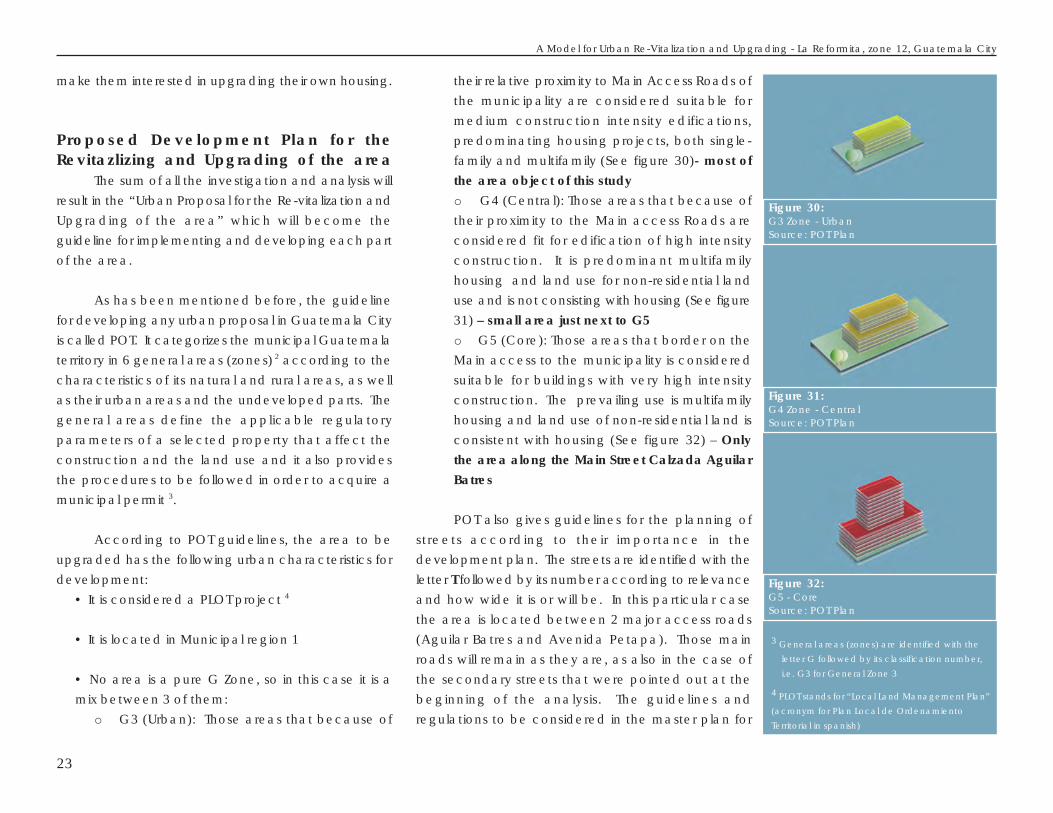
As has been mentioned before, the guidelinefor developing any urban proposal in Guatemala Cityis called POT. It categorizes the municipal Guatemalaterritory in 6 general areas (zones) 2 according to thecharacteristics of its natural and rural areas, as wellas their urban areas and the undeveloped parts. Thegeneral areas define the applicable regulatoryparameters of a selected property that affect theconstruction and the land use and it also providesthe procedures to be followed in order to acquire amunicipal permit 3.
According to POT guidelines, the area to beupgraded has the following urban characteristics fordevelopment:
• It is considered a PLOT project 4
• It is located in Municipal region 1
• No area is a pure G Zone, so in this case it is amix between 3 of them:
o G3 (Urban): Those areas that because of
their relative proximity to Main Access Roads ofthe municipality are considered suitable formedium construction intensity edifications,predominating housing projects, both single-family and multifamily (See figure 30)- most ofthe area object of this studyo G4 (Central): Those areas that because oftheir proximity to the Main access Roads areconsidered fit for edification of high intensityconstruction. It is predominant multifamilyhousing and land use for non-residential landuse and is not consisting with housing (See figure31) – small area just next to G5o G5 (Core): Those areas that border on theMain access to the municipality is consideredsuitable for buildings with very high intensityconstruction. The prevailing use is multifamilyhousing and land use of non-residential land isconsistent with housing (See figure 32) – Onlythe area along the Main Street Calzada AguilarBatres
POT also gives guidelines for the planning ofstreets according to their importance in thedevelopment plan. The streets are identified with theletter T followed by its number according to relevanceand how wide it is or will be. In this particular casethe area is located between 2 major access roads(Aguilar Batres and Avenida Petapa). Those mainroads will remain as they are, as also in the case ofthe secondary streets that were pointed out at thebeginning of the analysis. The guidelines andregulations to be considered in the master plan for
23
3 General areas (zones) are identified with the
letter G followed by its classification number,
i.e. G3 for General Zone 3
4 PLOT stands for “Local Land Management Plan”
(acronym for Plan Local de Ordenamiento
Territorial in spanish)
Figure 32:G5 - CoreSource: POT Plan
Figure 30:G3 Zone - UrbanSource: POT Plan
Figure 31:G4 Zone - CentralSource: POT Plan
A Model for Urban Re-Vitalization and Upgrading - La Reformita, zone 12, Guatemala City
the Re-vitalizing and upgrading proposals are asfollows:
• Main Streets will remain as they are, as they willcontinue to provide access to the city from all theperiphery areas. The lanes are for mixed traffic(motorcycles, cars, and public transport includingthe “Transmetro”)
• Secondary Streets will remain as they areincluding the ones that had been marked in figure22. In addition to this, there are considerations tobe made regarding the “Primary Road System andits relation to the POT”
o For this plan the Road system that appliesare T0, T2 and T3
It is also important to consider that POT alsoregulates the land use, it gives a minimum percentageof land use according to its zoning (G zones),depending on what zone is to be developed andhow much construction is permitted for the specificland use. In this case the regulation provides that itis permitted to have mixed land use being that, housingand commercial. This is an advantage for the area,because to be an integrated proposal there shouldbe spaces for every activity such as housing,commerce and leisure. The regulations will thus permitthe reactivation of the area.
The guidelines for zones G3 and G4 are asfollows:
• G3: will allow 50% housing at minimum
• G4: will allow 35% housing at minimum
The results of all of the considerations presentedabove are the Urban Proposal that can be describedas follows (See figure 33):
• As a whole:o It is important that the primary and secondaryexisting streets are respected and leave themas they are.o The existing commerce should be allowedto remain where it is because it has beenestablished by the public. The way to integrateit in the upgrading process is to remodel theirfacades. The businesses are will ing tocollaborate with the implementation of the PilotProjecto Public transport is available on the 2 streetsthat work as boundaries to the project area,and Transmetro operates on Calzada AguilarBatreso There should be a proposal for implementingan inner bus service for the inhabitants livingand working in the area. The vehicles that wouldbe used as buses should be smallo There is existing and working infrastructurein the area. This has to be evaluated todetermine if it has sufficient capacity to coverthe demand generated by the upgradingproposals, if it is not enough some modificationswill have to be done to the network in order tosupply the demand.
Ana Lucia Ruano Robles
24

• Pilot Projecto The 3 scenarios described above, arerepresented in different shades of red, definingthe housing areas distributed in groups.o Greening areas and public spaces andrelated provision: Will not only consider greening,but also urban equipment, lightning and apedestrian and cycle path for the inhabitantsto be free for to walk or to take a bicycle ride. They are considered also “igniting projects” butthey should be sponsored by the municipalauthorities and by the education sector as wellsince the public university is in the surroundings. These areas include space that should be usedfor promoting cultural activities as well as thecommunity participation and bonding.o Relocation of Commerce and Education:The commerce that is scattered all over thearea at present should be re located into aspecific area designed for this purpose. Therelocation will bring order to the area and wouldprevent the mixed use of a housing unit. Thiswill reactivate the commerce and initiateinvestments in the area. Regarding the publicschooling, this also will be integrated into theproposals in the space set aside for them.
Implementation and Investment alternatives
ImplementationThe implementation of the pilot project has to
be done in phases, due the size of the area. The
starting point of the study analysis is to define the areathat is suitable for revitalization without having to investas heavy as in a new development project and toget the community interested in improving their qualityof life as well as helping the economics in the area.
To support the implementation processguidelines for the process are provided that shouldbe considered in the process of planning anddesigning for an urban revitalization and/or upgradingproject with proposals for areas that share similarcharacteristics, based on the fact that this is a pilotproject.
• Diagnosis phase: At this stage all the backgroundinformation will be collected for a betterunderstanding of the area, its history and thepresent situation in all aspects regarding integratedurban planning, such as existing urban infrastructure,architecture, human aspects, economics andpublic services.
• SWOT and results interpretation: An initial SWOTis done to corroborate that the area is suitable asan integrated urban planning project in whichcase the planning initiative has to be taken to thecommunity for information and to allow thecommunity to become an active part of theprocess. This is a way of finding out the realnecessities of the area, seen through the eyes ofits inhabitants (stakeholders). Communityparticipation should be done in sequences, bescheduled and through organized workshops with
25
A Model for Urban Re-Vitalization and Upgrading - La Reformita, zone 12, Guatemala City

some representatives of the community where itwill be implemented. This allows the stakeholdersto take active part in the process and get theminterested in collaborating.
• Implementation Strategy: This is where the urbanproposal is drafted and defined, the result is aMaster Plan that will be implemented, and it coversall the aspects and objectives that came out duringthe investigation.
Because of the size of the master plan theimplementation should be done in phases, startingwith igniting projects to attract investors to the area,as well as getting the community interested inparticipating and allowing the changes. For eachscenario there has to be a planning process and eachof them represents individual projects that in the endwill make the Master Plan work. Each phase shouldbe started with an igniting project to attract investmentand gaining money for developing the rest of thephase and also to help start up the next one. Aprudent time for the rehabilitation of the whole areashould be 10 years.
In the pilot project the igniting project will be ablock to develop apartment buildings to satisfy thedemand of housing for students and families in thearea. This has to be done along with the collaborationof the municipality, so that the greening projects canbe developed simultaneously with the different phasesof the implementation. This phase includes theacquisition of the land, architectural planning,
Ana Lucia Ruano Robles
26
Figure 33:Urban Proposal - Master Plan
Green areas(parks, plazas and areas for leisure and cultural activities)
Commercial Area(commerce, schooling and public services)
Housing 1(Middle Income - Apartment buildings)
Green Walk(a pedestrian walk with a bicycle lane)
Housing 2(Middle Income - Single family units, houses)
Housing 3(Low Income, social housing - Mix of single units and Apartment buildings)

relocating agreements for the families that will berelocated (i.e. selling their land or housing them forthe construction period in exchange for a housingunit), completion and getting people to move backto the area and thus start to reactivate it.
• Monitoring is an important part of theimplementation process. It should be done in 2different levels, firstly at the execution level to ensurethat the deadlines are met and to supervise andmake sure that the urban proposal is beingdeveloped as it was planned. Secondly, at theplanning level, to see if there are some changesthat can be made to make the proposal better orfind new ways of funding or simply changing thephasing of the implementation.
It is recommended that the monitoring is doneperiodically at each level, i.e. at planning level therecan be monthly meetings to evaluate the progress,and then revised every 6 months to make biggerdecisions and finally the master plan should be revisedevery 10 years.
Investment AlternativesThe preparation and development of the plan
has to be made in a “step by step” process (phases). This is for practical reasons as conditions will changeover time and there is a need to be able to adjust tochanging circumstances. It is also necessary to getfunding for each subsequent phase, while developingone. Further it is necessary to find strategies that will
allow the development of some parts of the proposalsin case of lack of funding occurs and the phasecannot be concluded. This may not be the bestscenario but will allow for flexibility and help the processto revitalize and create public spaces in an areawhere there are none.
There are several funding alternatives that canbe considered for the implementation of this plan,because it is a fact that there is no municipal moneyfor them to develop it by themselves, and theinhabitants’ lack of economic resources as well. Thisis why private investment has to be part of theinvestment alternatives, as well as internationalinvestments. The funding can come from public andprivate sources.
Here are some alternatives that can bepromoted to get funding for the implementation ofthe urban proposal:
• Public funds that come up from taxes should beset aside for the green areas to be developedalong with the different phases of the planimplementation. Tax incentives should be the firststage of public fund management
• For the industrial area located at the south ofthe university and along Calzada Atanasio Tzuland Calzada and the commerce that are alreadysituated along the principal streets, the municipalityshould come up with a plan of tax incentives. Inthat way they can use that savings to repair andmaintain the facades, which would be seen as
A Model for Urban Re-Vitalization and Upgrading - La Reformita, zone 12, Guatemala City
27

part of the upgrading and environmentalimprovement of their surroundings. This will givethe area a better image.• Private Funding can come up from differentsources:
o International Investment: Guatemala hasexcellent relations with European countries thathave an interest in helping in the country´sdevelopment. This can be a way for them toinvest directly in improving the quality of theliving environment in an existing area withouthaving to do all the initial investments ininfrastructure and in new land development.(i.e. Germanys KFW or Spanish CooperationFunds). Investment of this kind is very feasiblebecause such projects can be replicated in thewhole Central America regiono Private Sector: Developing companies thatmain field of operation of business is architecture;urban planning and construction would besuitable investors to support the projectfinancially as there will be opportunities forprofitable returns. This can represent a greatproject for both sides interested and once itsstarted it will attract more investorso NGO´s: The NGOs that are engaged in thesocial field, slum upgrading, and similar aspectsof community support, are likely to have aninterest in getting involved in helping to improvethe life of people by promoting and fundingprojects that will benefit the whole communitythat has middle or low income.
Once the project is being implemented andthe community can see the visible changes and canbenefit from them, it will draw little by little more interestin the area, both for living and for investing. Theinternational investments will give reassurance to thenational capital and finance.
This is an important area because although ithas been neglected, it keeps the old planningparameters with much wider streets than the rest ofthe city or the new urban development. Despite theintensity of traffic in its surroundings, the traffic flows“without much trouble” compared to other areas ofthe city.
In terms of the Urban Planning aspects overallit is an area without major topographic problems likebridges, slopes or river gorges, which is found in somany other places in the peripheries of the city area. Furthermore the area is already developed as far asthe urban structure is concerned and has existinginfrastructure. This means that the investments willbenefit as it needs limited investments regardinginfrastructure. The drainage system will probablyrequire minor modifications, since it is crossed by thelarge sewage system built in the 1980´s, and apparentlydespite sustained urban growth, it still meet the designparameters and it has apparently not manifested anyproblems in terms of waste flows.
Ana Lucia Ruano Robles
28

CONCLUSIONS AND RECOMMENDATIONSCONCLUSIONS1. In spite of the abandonment of residential inhabitants from the zone it is considered a salvageable area,s ince i t has the ent i re infrastructure necessary for being upgraded and re-vital ized
2. The revaluation of “La Reformita” implies the necessity of the conjunction of the architecs, urban planners,architects, engineers and environmentalists to make it an integrated project
3. The improvement of the urban landscape and the architectural value of La Reformita re the economyin the area and the implementation of urban equipment and green areas will contribute to a better livingarea attracting the people to move back to the area and increasing the land value
4. The igniting projects will become the main tool for funding and drawing the attention to the upgradingfor the area, so that further in time more people become interested in investing in the implementation of thisplan
5. The development of a proposal of a model for upgrading and the revitalizing program will help themunicipal authorities to implement improvements in different areas of the city that are suitable for change.
RECOMMENDATIONS1. It is important to prepare proposals for urban upgrading and to provide revitalizing guidelines as a modelin order to ensure that the deteriorating areas can be improved and that the city sprawl will be slowed down.
2. It would be desirable that the community receives a copy of their “improvement plan” so that they becomemore active and can participate on the process
3. It is necessary to involve not only municipal authorities and investors but also the community in themaintenance plan with the purpose of that they become aware of the cultural, economic and socialimportance of their own neighborhood.
4. Taking into account that the area is mainly a housing area and that it is close to the national university,the planning should encourage cultural and health related activities
A Model for Urban Re-Vitalization and Upgrading - La Reformita, zone 12, Guatemala City
29

REFERENCES
1. Analisis Cartografico de la Ciudad 1776 a 1976, 2000 años de Urbanismo. Arévalo Fong, Guillermo Antonio.Universidad de San Carlos, Facultad de Arquitectura 1979.
2. Centros Urbanos Peatonales, Planificación, proyecto y gestión de zonas sin tráfico. Brambilla, Roberto yLongo, Gianni. Editorial oikos-tau, s.a. Barcelona, España.
3. Metrópolis 2,010. Metrópolis 2,010. Plan de desarrollo metropolitano. La Planificacion integral de la Ciudad.Municipalidad de Guatemala. 1995.
4. Guia de Aplicacion del POT. Fisrt Edition. Municipalidad de Guatemala. 2009 (POT Application Guide)
5. Revaluation of Callejón del Fino - Design of the Urban Evolution Museum of the Historical Centre ofGuatemala. Advanced Training Programme of Conservation & Management of Historic BuildingsLund Univerity. Ana Cecilia Zurita Fuentes. 2006
6. World Wide Web pages
Ana Lucia Ruano Robles
30