Completely Exhausted: Evaluating the Impact of Woodford v ...
INSTRUCTIONS
To the
SURVEYORS GENERAL OF PUBLIC LANDS
Of
THE UNITED STATES
For those
SURVEYING DISTRICTS ESTABLISHED IN AND SINCE THE YEAR 1850;
Containing, also,
A MANUAL OF INSTRUCTIONS
To
REGULATE THE FIELD OPERATIONS OF DEPUTY SURVEYORS,
Illustrated by diagrams.
Described, according to law, by the principal clerk of surveys,Pusuant to order of the Commissioner of The General Land Office.
WASHINGTON:A.O.P. Nicholson, Public Printer
1855
Reprinted by the Kansas Society of Land Surveyors, 1996Adapted to PDF format by the Kansas Society of Land Surveyors, 1999
SURVEYORS G
TH
SURVEYING DISTRICTS
A MANU
REGULATE THE FIEL
ILLUST
PRESCRIBED, ACCORDING TO LORDER OF THE CO
WA.O.P
INSTRUCTIONS
TO THE
ENERAL OF PUBLIC LANDS
OF
E UNITED STATES
FOR THOSE
ESTABLISHED IN AND SINCE THE YEAR 1850;
CONTAINING, ALSO,
AL OF INSTRUCTIONS
TO
D OPERATIONS OF DEPUTY SURVEYORS,
RATED BY DIAGRAMS
AW, BY THE PRINCIPAL CLERK OF SURVEYS, PURSUANT TOMMISSIONER OF THE GENERAL LAND OFFICE.
ASHINGTON:. Nicholson, Public Printer
1855
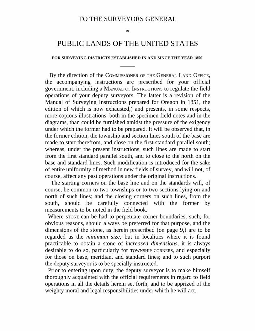
TO THE SURVEYORS GENERALOF
PUBLIC LANDS OF THE UNITED STATES
FOR SURVEYING DISTRICTS ESTABLISHED IN AND SINCE THE YEAR 1850.
By the direction of the COMMISSIONER OF THE GENERAL LAND OFFICE,the accompanying instructions are prescribed for your officialgovernment, including a MANUAL OF INSTRUCTIONS to regulate the fieldoperations of your deputy surveyors. The latter is a revision of theManual of Surveying Instructions prepared for Oregon in 1851, theedition of which is now exhausted,) and presents, in some respects,more copious illustrations, both in the specimen field notes and in thediagrams, than could be furnished amidst the pressure of the exigencyunder which the former had to be prepared. It will be observed that, inthe former edition, the township and section lines south of the base aremade to start therefrom, and close on the first standard parallel south;whereas, under the present instructions, such lines are made to startfrom the first standard parallel south, and to close to the north on thebase and standard lines. Such modification is introduced for the sakeof entire uniformity of method in new fields of survey, and will not, ofcourse, affect any past operations under the original instructions. The starting corners on the base line and on the standards will, ofcourse, be common to two townships or to two sections lying on andnorth of such lines; and the closing corners on such lines, from thesouth, should be carefully connected with the former bymeasurements to be noted in the field book. Where STONE can be had to perpetuate corner boundaries, such, forobvious reasons, should always be preferred for that purpose, and thedimensions of the stone, as herein prescribed (on page 9,) are to beregarded as the minimum size; but in localities where it is foundpracticable to obtain a stone of increased dimensions, it is alwaysdesirable to do so, particularly for TOWNSHIP CORNERS, and especiallyfor those on base, meridian, and standard lines; and to such purportthe deputy surveyor is to be specially instructed. Prior to entering upon duty, the deputy surveyor is to make himselfthoroughly acquainted with the official requirements in regard to fieldoperations in all the details herein set forth, and to be apprized of theweighty moral and legal responsibilities under which he will act.
( iv )
Unfaithfulness in the execution of the public surveys will be detectedby special examinations of the work to be made for that purpose, and,when detected, will immediately subject the delinquent deputy and hisbondsmen to be sued by the district attorney of the United States, atthe instance of the proper surveyor general ---the institution of whichsuit will act at once as a lien upon any property owned by him or themat that time; and such delinquency, moreover, is an offence punishableby the statute, with all the pains and penalties of perjury, (see act of1846, quoted on pages 19 and 20 hereof,) and will of necessity debarthe offending deputy from future employment in like capacity. Hence,in the execution of contracts for surveying public lands, there is everyincentive to fidelity that can address itself either to the moral sense, orto motives of private interest. By order of the Commissioner:
JOHN M. MOORE,Principal Clerk of Surveys
GENERAL LAND OFFICE,February 22, 1855
TABLE OF CONTENTS
Page
1, 2
2, 3, 445
5, 66, 7
8
8, 99
101112
12, 13, 1415, 1617, 18
18, 19
19
20
20, 21
21, 2222, 23, 24
2424
System of rectangular surveying; range, township, andsection lines; mode of numbering townships and sections.Standard parallels . . . . . . . . . . . . . . . . .
Of measurements, chaining, and marking; tally pins; process ofchaining . . . . . . . . . . . . . . . . . . . .
Marking lines; of trial or random lines . . . . . . . . . .Insuperable objects on line; witness points; marking irons . .Establishing corner boundaries; at what points for township;
section, quarter section, and meander corners, respectively .Manner of establishing corners by means of posts . . . . . .Notching corner posts . . . . . . . . . . . . . . . . .Bearing trees; how many at the different corners, and how to
be marked . . . . . . . . . . . . . . . . . . . .Stones for corner boundaries; minimum size; marking same . .Mounds around posts, of earth or stone; how to be constructed
and conditioned . . . . . . . . . . . . . . . . . .Mound memorials---witness mounds to corners. . . . . . .Double corners only on base and standard parallels . . . . .Meandering navigable streams, lakes, and deep ponds . . . .Field books for deputy surveyors . . . . . . . . . . . .Summary of objects and data to be noted in field books . . .Swamp lands granted to the State by act of 28th September,
1850; their outlines to be specially noted by the deputysurveyor. . . . . . . . . . . . . . . . . . . . .
Noting of settler’s claims in OREGON, WASHINGTON, and NEW
MEXICO . . . . . . . . . . . . . . . . . . . . .Affidavits to field notes, and provisions of act of 8th August,
1846, respecting the same. Pains and penalties which attachto false surveys . . . . . . . . . . . . . . . . . .
Forms of official oaths, prior to entering upon duty, for adeputy and his assistants . . . . . . . . . . . . . .
Exteriors or township lines; and limitations within which theymust close . . . . . . . . . . . . . . . . . . . .
Method of subdividing . . . . . . . . . . . . . . . .Limitations within which section and meander lines must closeOf Diagram A, showing a body of township exteriors . . . .
( vi )Page
Of Diagram B, showing the subdivision of a township into sec-tions . . . . . . . . . . . . . . . . . . . . . . . .
Of Diagram C, illustrating the mode of making mound, stake, andstone corners . . . . . . . . . . . . . . . . . . .
Subdivisions of fractional sections into forty-acre lots are to bemade by the surveyor general on the township plats, and tobe designated by special numbers, where they cannot be de-scribed as quarter-quarters . . . . . . . . . . . . . .
Township plats to be prepared by the surveyor general in triplicateTownship plats to be furnished to the General Land Office and to
the district land offices. Details to be shown thereon, respec-tively. . . . . . . . . . . . . . . . . . . . . . . .
“Descriptive notes,” showing the quality of soil and kind oftimber found on the surveyed lines in each township, and de-scribing each corner boundary, are to accompany the plat ofthe same, to be furnished by the surveyor general to the dis-trict land office . . . . . . . . . . . . . . . . . . .
The original field books of surveys, bearing the written approvalof the surveyor general, to be retained in his office . . . . .
Certified transcripts of field books to be furnished to GeneralLand Office . . . . . . . . . . . . . . . . . . . .
Meander corners to be numbered on township plats . . . . . . .Variation of the needle, and mode of ascertaining the same . . . .Specimen field notes A and B-----the former of the exterior lines of
a township, and the latter of the subdivision of the same-------constitute a separate series of pages from 1 to 53 inclusive; andthey are preceded by an INDEX referring the township, sec-tion, closing, and meander lines, as shown on Diagram B, totheir corresponding pages in the notes A and B . . . . . . .
The “General description” of the character of public land in thetownship follows the subdivisional notes, with a “list ofnames” of assistants, and the mode of authenticating the survey,under the provision of the act of 8th August, 1846, and a formfor certifying copies of field notes to be transmitted to the Gen-eral Land Office . . . . . . . . . . . . . . . . . . .
Conclusion. “Table showing the differences of latitude and de-parture in running 80 chains, at any course from 1 to 60minutes” . . . . . . . . . . . . . . . . . . . . . .
25
25
25, 2626
26
26
26
262628
1---53
54, 55, 56
56
SYSTEMOF
RECTANGULAR SURVEYING
1. The public lands of the United States are ordinarily surveyed intorectangular tracts, bounded by lines conforming to the cardinal points. 2. The public lands are laid off, in the first place, into bodies of landof six miles square, called Townships, containing as near as may be23,040 acres. The townships are subdivided into thirty-six tractscalled Sections, of a mile square, each containing as near as may be,640 acres. Any number or series of contiguous townships. situatenorth or south of each other, constitute a Range. The law requires that the lines of the public surveys shall begoverned by the true meridian, and that the townships shall be sixmiles square,-- two things involving in connexion a mathematicalimpossibility-- for, strictly to conform to the meridian, necessarilythrows the township out of square, by reason of the convergency ofmeridians, and hence, by adhering to the true meridian, results thenecessity of departing from the strict requirements of law, as respectsthe precise area of townships and the subdivisional parts thereof, thetownship assuming something of a trapezoidal form, which inequalitydevelopes itself more and more as such the higher latitude of thesurveys. It is doubtless in view of these circumstances that the lawprovides (see sec. 2 of the act of May 18, 1796) that the sections of amile square shall contain the quantity of 640 acres, as nearly as maybe; and moreover, provides (see sec. 3 of the act of 10th May, 1800)in the following words: “And in all cases where the exterior lines ofthe townships, thus to be subdivided into sections or half sections,shall exceed, or shall not extend six miles, the excess or deficienceyshall be specially noted, and added to or deducted from the western ornorthern ranges of sections or half sections in such township,according as the error may be in running the lines from east to west,or from south to north; the sections and half sections bounded on thenorthern and western lines of such townships shall be sold ascontaining only the quantity expressed in the returns and plats,respectively, and all others as containing the complete legal quantity.”
( 2 )
The accompanying diagram, marked A, will serve to illustrate themethod of running out the exterior lines of townships, as well on thenorth as on the south side of the base line; and the order and mode ofsubdividing townships will be found illustrated in the accompanyingspecimen field notes, conforming with the township diagram B. Themethod here presented is designed to insure as full a compliance withall the requirements, meaning, and intent of the surveying laws as, itis believed, is practible. The section lines are surveyed from south to north on true meridians,and from east to west, in order to throw the excesses or deficiences inmeasurements on the north and west sides of the township, asrequired by law. 3. The townships are to bear numbers in respect to the base lineeither north or south of it; and the tiers of townships. called “Ranges”will bear numbers in respect to the meridian line according to theirrelative position to it, either on the east or west. 4. The thirty-six sections into which a township is subdivided arenumbered, commencing with number one at the northeast angle of thetownship, and proceeding west to number six, and thence proceedingeast to number twelve, and so on, alternately, until the number thirty-six in the southeast angle. 5. STANDARD PARALLELS (usually called correction lines) areestablished at stated intervals to provide for or counteract, the errorthat otherwise would result from the convergency of meridians, andalso to arrest error arising from inaccuracies in measurements inmeridian lines, which, however must be studiously avoided. On thenorth of the paincipal* base line it is proposed to have these standardsrun at distances of every four townships, or twenty-four miles, and onthe south of the principal base, at distances of every five townships orthirty miles.
OF MEASUREMENTS, CHAINING, AND MARKING.
1. Where uniformity in the variation of the needle is not found, thepublic surveys must be made with an instrument operatingindependently of the magnetic needle. Burt’s improved solarcompass, or other instrument of equal quality, must be used ofnecessity in such cases; and it is deemed best that such instrumentshould be used under all circumstances. Where the needle can berelied on, however, the ordinary compass may be used in subdividingand meandering.* principal, misspelled in original document.
( 3 )
2. The township lines, and the subdivision lines, will usually bemeasured by a two-pole chain of thirty-three feet in length, consistingof fifty links, and each link being seven inches and ninety-twohundredths of an inch long. On uniform and level ground, however,the four-pole chain may be used. Your measurements will, however,always be represented according to the four-pole chain of onehundred links. The deputy surveyor must also have with him ameasure of the standard chain, wherewith to compare and adjust thechain in use, from day to day, with punctuality and carefullnes; andmust return such standard chain to the Surveyor Generals office forexamination when his work is completed.
OF TALLY PINS.
3. You will use eleven tally pins made of steel, not exceedingfourteen inches in length, weighty enough towards the point to makethem drop perpendicularly, and having a ring at the top, in which is tobe fixed a piece of red cloth, or something else of conspicuous color,to make them readily seen when stuck in the ground.
PROCESS OF CHAINING.
4. In measuring lines with a two-pole chain, every five chains arecalled “a tally;” because at that distance the last of the ten tally pinswith which the forward chainman set out will have been stuck. Hethen cries “tally;” which cry is repeated by the other chainman, andeach registers the distance by slipping a thimble. button, or ring ofleather, or something of the kind, on a belt worn for that purpose, orby some other convenient method. The hind chainman then comes up,and having counted in the presence of his fellow the tally pins whichhe has taken up, so that both may be assured that none of the pinshave been lost, he then takes the forward end of the chain andproceeds to set the pins. Thus the chainmen alternately change places,each setting the pins that he has taken up, so that one is forward in allthe odd, and the other in all the even tallies. Such procedure, it isbelieved, tends to insure accuracy in measurement, facilitates therecollection of distances to objects on the line, and renders a mistallyalmost impossible.
LEVELLING THE CHAIN AND PLUMBING THE PINS.
5. The length of every line you run is to be ascertained by precisehorizontal measurement, as nearly approximating to an air line as ispos-
( 4 )
sible in practice on the earth’s surface. This all important object canonly be attained by a rigid adherence to the following threeobservances: 1. Ever keeping the chain stretched to its utmost degree of tensionon even ground. 2. On uneven ground, keeping the chain not only stretched asaforesaid, but horizontally levelled. And when ascending anddescending steep ground, hills or mountains, the chain will have to beshortened to one-half its length (and sometimes more,) in orderaccurately to obtain the true horizontal measure. 3. The careful plumbing of the tally pins. so as to obtain preciselythe spot where they should be stuck. The more uneven the surface, thegreater the caution needed to set the pins.
MARKING LINES.
6. All lines on which are to be established the legal cornerboundaries are to be marked after this method, viz: Those trees whichmay intercept your line must have two chops or notches cut on eachside of them without any other marks whatever. These are called“sight trees,” “line trees,” or “station trees.” A sufficient number of other trees standing nearest to your line, oneither side of it, are to be blazed on two sides diagonally, orquartering towards the line, in order to render the line conspicuous,and readily to be traced, the blazes to be opposite each other,coinciding in direction with the line where the trees stand very near it,and to approach nearer each other the further the line passes from theblazed trees. Due care must ever be taken to have the lines so wellmarked as to be readily followed.
ON TRIAL, OR RANDOM LINES,
the trees are not to be blazed, unless occasionally from indispensablenecessity, and then it must be done so guardedly as to prevent thepossibility of confounding the marks of the trial line with the true.But bushes and limbs of trees may be lopped. and stakes set on thetrial, or random line, at every ten chains, to enable the surveyor on hisreturn to follow and correct the trial line, and establish therefrom thetrue line. To prevent confusion, the temporary stakes set on the trial,or random lines, must be pulled up when the surveyor returns toestablish the true line.
( 5 )INSUPERABLE OBJECTS ON LINE ----- WITNESS POINTS.
7. Under circumstances where your course is obstructed by impassableobstacles, such as ponds, swamps, marshes, lakes, rivers, creeks, &c.,you will prolong the line across such obstacles by taking the necessaryright angle offsets; or if such be inconvenient, by a traverse ortrigonometrical operation, until you regain the line on the opposite side.And in case a north and south or a true east and west, line is regained inadvance of any such obstacle, you will prolong and mark the line backto the obstacle so passed, and state all the particulars in relation theretoin your field book. And at the intersection of lines with both margins ofimpassable obstacles, you will establish a Witness Point, (for thepurpose of perpetuating the intersections therewith,) by setting a post,and giving in your field book the course and distance therefrom to twotrees on opposite sides of the line, each of which trees you will markwith a blaze and notch facing the post; but on the margins of navigablewater courses, or navigable lakes, you will mark the trees with theproper number of the fractional section, township and range. The best marking tools adapted to the purpose must beprovided for marking neatly and distinctly all the letters and figuresrequired to be made at corners; and the deputy is to have always athand the necessary implements for keeping his marking irons inorder; for which purpose a rat-tail file and a small whetstone will befound indispensable.
ESTABLISHING CORNER BOUNDARIES
To procure the faithful execution of this portion of a surveyor’s dutyis a matter of the utmost importance. After a true coursing, and mostexact measurements, the corner boundary is the consummation of thework, for which all the previous pains and expenditures have beenincurred. If, therefore, the corner boundary be not perpetuated in apermanent and workmanlike manner, the great aim of the surveyingservice will not have been attained. A boundary corner, in a timberedcountry is to be a tree, if one be found at the precise spot; and if not, apost is to be planted thereat; and the position of the corner post is tobe indicated by trees adjacent, the angular bearings and distances ofwhich from the corner are facts to be ascertained and registered inyour field book. (See article, “Bearing trees.”)
( 6 )
In a region where stone abounds the corner boundary will be a smallmonument of stones along side of a single marked stone for atownship corner, and a single stone for all other corners. In a region where timber is not near, and stone not found, the cornerwill be a mound of earth, of prescribed size, varying to suit the case. The following are the different points for perpetuating corners, viz: 1. For township boundaries, at intervals of every six miles. 2. For section boundaries, at intervals of every mile, or 80 chains. 3. For quarter section boundaries, at intervals of every half mile, or40 chains. Exceptions, however, occur on east and west lines, asexplained hereafter. [The half quarter section boundary is not marked in the field, but isregarded by the law as a point of intermediate between the half mile,or quarter section corners. See act of 24th April, 1820, entitled “Anact making further provision for the sale of the public lands,” whichact refers to the act of Congress passed on the 11th of February, 1805,entitled “An act concerning the mode of surveying the public lands ofthe United States,” for the manner of ascertaining the corners andcontents of half quarter sections.]* 4. MEANDER CORNER POSTS are planted at all those points where thetownship or section lines intersect the banks of such rivers, bayous,lakes, or islands, as are by law directed to be meandered. The courses and distances on meandered navigable streams governthe calculations wherefrom are ascertained the true areas of the tractsof land (sections, quarter sections, &c.) known to the law asfractional, and binding on such streams.
MANNER OF ESTABLISHING CORNERS BY MEANS OF POSTS.
Township, sectional, or mile corners, and quarter sectional or halfmile corners, will be perpetuated by planting a post at the place of thecorner, to be formed of the most durable wood of the forest at hand. The posts must be set in the earth by digging a hole to admit themtwo feet deep, and must be very securely rammed in with the earth,and also with stone, if any be found at hand. The portion of the postwhich protrudes above the earth must be squared off sufficientlysmooth to admit if receiving the marks thereon, to be made withappropriate marking irons, indicating what it stands for. Thus thesides of township
*The subdivision of the half-quarter section into quarter-quarter sections isauthorized by “An act supplementary to the several laws for the sale of the publiclands,” approved April 5, 1832.

( 7 )
corner posts should square at least four inches, (the post itself being fiveinches in diameter,) and must protrude two feet at least above theground; the sides of section corner posts must square at least threeinches, (the post itself being four inches in diameter,) and protrude twofeet from the ground; and the quarter section corner posts and meandercorner posts must be three inches wide, presenting flattened surfaces,and protruding two feet from the ground.
Where a township post is a corner common to four townships, it is tobe set diagonally, thus:
NW E
SOn each surface of the post is to be marked the number of the particulartownship, and its range, which it faces. Thus, if the post be a commonboundary to four townships --- say one and two, south of the base line,of range one, west of the meridian; also to townships one and two, southof the base line, of range two, west of the meridian, it is to be markedthus:
These marks are not only to be distinctly but neatly cut into the wood, atleast the eighth of an inch deep; and to make them yet more conspicuousto the eye of the anxious explorer, the deputy must apply to all of them astreak of red chalk. Section or mile posts, being corners of sections, and where such arecommon to four sections, are to be set diagonally in the earth, (in themanner provided for township corner posts;) and on each side of thesquared surfaces (made smooth, as aforesaid, to receive the marks) is tobe marked the appropriate number of the particular one of the foursections, respectively, which such side faces; also on one side thereofare to be marked the numbers of its township and range; and to makesuch marks yet more conspicuous, in manner aforesaid, a streak of redchalk is to be applied.
In every township, subdivided into thirty-six sections, there are twenty -five interior section corners, each of which will be common to foursections. A quarter section, or half mile post, is to have no other mark on it than¼ S., to indicate what it stands for.
( 8 )NOTCHING CORNER POSTS.
Township corner posts, common to four townships, are to be notchedwith six notches on each of the four angles of the squared part set to thecardinal points. All mile posts on township lines must have as many notches on them,on two opposite angles thereof, as they are miles distant from the town– ship corners respectively. Each of the posts at the corners of sectionsin the interior of a township must indicate, by a number of notches oneach of its four corners directed to the cardinal points, thecorresponding number of miles that it stands from the outlines of thetownship. The four sides of the post will indicate the number of thesection they respectively face. Should a tree be found at the place of anycorner, it will be marked and notched as aforesaid, and answer for thecorner in lieu of a post, the kind of tree and its diameter being given inthe field notes.
BEARING TREES.
The position of all corner posts, or corner trees, of whatever description,that may be established, is to be evidenced in the following manner, viz:From such post or tree the courses must be taken and the distancesmeasured to two or more adjacent trees in opposite directions, as nearlyas may be, and these are called “bearing trees.” Such are to bedistinguished by a smooth blaze, with a notch at its lower end, facingthe corner, and in the blaze to be marked the number of the range,township, and section; but at quarter section corners nothing but ¼ S.need be marked. The letters B. T. (bearing tree) are also to be markedupon a smaller blaze directly under the large one, and as near the groundas practicable. At all township corners, and at all section corners, on range ortownship lines, four bearing trees are to be marked in this manner, onein each of the adjoining sections. At interior section corners four trees, one to stand within each of thefour sections to which such corner is common, are to be marked inmanner aforesaid, if such be found. A tree supplying the place of a corner post is to be marked in themanner directed for posts; but if such tree should be a beech, or othersmooth bark tree, the marks may be made on the bark, and the treenotched. From quarter section and meander corners two bearing trees are to bemarked, one within each of the adjoining sections.

( 9 )
Where the requisite number of “bearing trees” is not to be found atconvenient and suitable distances, such as are found are to be marked asherein directed; but in all such cases of deficiency in the number ofbearing trees (unless, indeed, the boundary itself be a tree,) aquadrangular trench, with sides of five feet, and with the angles to thecardinal points, must be spaded up outside the corner, as a centre, andthe earth carefully thrown on the inside, so as to form a range of earth,which will become covered with grass, and present a small squareelevation, which in aftertime will serve to mark, unmistakably, the spotof the corner.
CORNER STONES.
Where it is deemed best to use STONES for boundaries, in lieu of posts,you may, at any corner, insert endwise into the ground, to the depth of 7or 8 inches, a stone, the number of cubic inches in which shall not beless than the number contained in a stone 14 inches long, 12 incheswide, and 3 inches thick – equal to 504 cubic inches – the edges ofwhich must be set north and south, on north and south lines, and eastand west, on east and west lines; the dimensions of each stone to begiven in the field notes at the time of establishing the corner. The kindof stone should also be stated.
MARKING CORNER STONES.
Stones at township corners, common to four townships, must have sixnotches, cut with a pick or chisel on each edge or side towards thecardinal points; and where used as section corners on the range andtown – ship lines, or as section corners in the interior of a township,they will also be notched, to correspond with the directions given fornotching posts similarly situated. Posts or stones at township corners on the base and standard lines, andwhich are common to two townships on the north side thereof, will havesix notches on each of the west, north, and east sides or edges; andwhere such stones or posts are set for corners to two townships south ofthe base or standard, six notches will be cut on each of the west, south,and east sides or edges. Stones, when used for quarter section corners, will have ¼ cut on them– on the west side on north and south lines, and on the north side on eastand west lines.
A---2
( 10 )MOUNDS.
Whenever bearing trees are not found, mounds of earth, or stone, are tobe raised around posts on which the corners are to be marked in themanner aforesaid. Wherever a mound of earth is adopted, the same willpresent a conical shape; but at its base, on the earth’s surface, aquadrangular trench will be dug; by the “trench” (here meant) is to beunderstood a spade deep of earth thrown up from the four sides of theline, outside the trench, so as to form a continuous elevation along itsouter edge. In mounds of earth, common to four townships or to foursections, they will present the angles of the quadrangular trench(diagonally) towards the cardinal points. In mounds common only totwo townships or two sections, the sides of the quadrangular trench willface the cardinal points. The sides of the quadrangular trench at the baseof a township mound are to be six feet, the height of the mound threefeet. At section, quarter section, and meander corners, the sides of thequadrangular trench at base of mounds are to be five feet, and theconical height two and a half feet. Prior to piling up the earth to construct a mound, there is to be dug aspadefull or two of earth from the corner boundary point, and in thecavity so formed is to be deposited a marked stone or a portion ofcharcoal, (the quantity whereof is to be noted in the field book;) or inlieu of charcoal or marked stone, a charred stake is to be driven twelveinches down into such centre point: either of those will be a witness forthe future, and whichever is adopted, the fact is to be noted in the fieldbook. When mounds are formed of earth, the spot from which the earth istaken is called the “pit,” the centre of which ought to be, whereverpracticable, at a uniform distance and in a uniform direction from thecentre of the mound. There is to be a “pit” on each side of everymound., distant eighteen inches outside of the trench. The trench may beexpected hereafter to be covered by tufts of grass, and thus to indicatethe place of the mound, when the mound itself may have becomeobliterated by time or accident. At meander corners the “pit” is to be directly on the line, eight linksfurther from the water than the mound. Whenever necessity is found fordeviating from these rules in respect to the “pits,” the course anddistance to each is to be stated in the field books. Perpetuity in the mound is a great desideratum. In forming it with lightalluvial soil the surveyor may find it necessary to make due allowancefor the future settling of the earth, and thus making the mound
( 11 )
more elevated than would be necessary in a more compact and tenacioussoil, and increasing the base of it. In so doing, the relative proportionsbetween the township mound and other mounds is to be preserved asnearly as may be. The earth is to be pressed down with the shovel during the process ofpiling it up. Mounds are to be covered with sod, grass side up, wheresod is to be had: but, in forming a mound, sod is NEVER to be wrought upwith the earth, because sod decays, and in the process of decomposing itwill cause the mound to become porous, and therefore liable topremature destruction.
POSTS IN MOUNDS
must show above the top of the mound ten or twelve inches, and benotched and marked precisely as they would be for the same cornerwithout a mound.
MOUND MEMORIALS.
Besides the charcoal. marked stone or charred stake, one or the otherof which must be lodged in the earth at the point of the corner, thedeputy surveyor is recommended to plant midway between each pit andtrench, seed of some trees, (those of fruit trees adapted to the climatebeing always preferred,) so that, in course of time, should such takeroot, a small clump of trees may possible hereafter note the place of thecorner. The facts of planting such seed, and the kind thereof, arematters to be truthfully noted in the field book.
WITNESS MOUNDS TO TOWNSHIP OR SECTION CORNERS.
If a township or section corner, in a situation where bearing or witnesstrees are not found within a reasonable distance therefrom, shall fallwithin a ravine, or in any other situation where the nature of the ground,or the circumstances of its locality, shall be such as may prevent, orprove unfavorable to, the erection of a mound, you will perpetuate suchcorner by selecting in the immediate vicinity thereof a suitable plot ofground as a site for a bearing or witness mound, and erect thereon amound of earth in the same manner and conditioned in every respect,with charcoal, or charred stake deposited beneath, as before directed;and measure and state in your field book the distance and course fromthe position of the true corner of the bearing or witness mound so placedand erected.
( 12 )DOUBLE CORNERS.
Such corners are to be nowhere except on the base and standard lines,whereon are to appear both the corners which mark the intersections ofthe lines which close thereon, and those from which the surveys start onthe north. On these lines, and at the time of running the same, thetownship, section, and quarter section corners are to be planted, andeach of these is a corner common to two, (whether township or sectioncorners,) on the north side of the line, and must be so marked. The corners which are established on the standard parallel, at the timeof running it, are to be known as “standard corners,” and, in addition toall the ordinary marks, (as herein prescribed,) they will be marked withthe letters S. C. Closing corners will be marked with the letters C. C. inaddition to other marks.The standard parallels are designed to be run in advance of thecontiguous surveys on the south of them, but circumstances may existwhich will impede or temporarily delay the due extension of thestandard; and when, from uncontrollable causes, the contiguoustownships must be surveyed in advance of the time of extending thestandard, in any such event it will become the duty of the deputy whoshall after- wards survey any such standard to plant thereon the doubleset of corners, to wit, the standard corners to be marked S. C., and theclosing ones which are to be marked C. C.; and to make suchmeasurements as may be necessary to connect the closing corners andcomplete the unfinished meridianal lines of such contiguous and priorsurveys, on the principles herein set forth, under the different heads of“exterior or township lines,” and of “diagram B.” You will recollect that the corners, (whether township or sectioncorners,) which are common to two, (two townships or two sections) arenot to be planted diagonally like those which are common to four, butwith the flat sides facing the cardinal points, and on which the marksand notches are made as usual. This, it will be perceived, will serve yetmore fully to distinguish the standard parallels from all other lines.
THE MEANDERING OF NAVIGABLE STREAMS.
1. Standing with the face looking down stream, the bank on the lefthand is termed the “ left bank” and that on the right hand the “rightbank.” These terms are to be universally used to distinguish the twobanks of ariver* or stream.*”a river” was printed as one word in the original document.
( 13 )
2. Both banks of navigable rivers are to be meandered by taking thecourses and distances of their sinuosities, and the same are to be enteredin the field book. At those points where either the township or section lines intersect thebanks of a navigable stream, POSTS, or, where necessary, MOUNDS ofearth or stone, are to be established at the time of running these lines.These are called “meander corners;” and in meandering you are tocommence at one of those corners on the township line, coursing thebanks, and measuring the distance of each course from yourcommencing corner to the next “meander corner,” upon the same oranother boundary of the same township, carefully noting yourintersection with all intermediate meander corners. By the same methodyou are to meander the opposite bank of the same river. The crossing distance between the MEANDER CORNERS on same line is tobe ascertained by triangulation, in order that the river may be protractedwith entire accuracy. The particulars to be given in the field notes. 3. You are also to meander, in manner aforesaid, all lakes and deepponds of the area twenty-five acres and upwards; also navigable bayous;shallow ponds, readily to be drained, or likely to dry up, are not to bemeandered. You will notice all streams of water falling into the river, lake, orbayou you are surveying, stating the width of the same at their mouth;also all springs, noting the size thereof and depth, and whether the waterbe pure or mineral; also the head and mouth of all bayous; and allislands, rapids, and bars are to be noticed, with intersection to theirupper and lower points to establish their exact situation. You will alsonote the elevation of the banks of rivers and streams, the heights of fallsand cascades, and the length of rapids. 4. The precise relative position of islands, in a township madefractional by the river in which the same are situated, is to bedetermined trigonometrically---sighting to a flag or other fixed objecton the island; from a special and carefully measured base line,connected with the surveyed lines, on or near the river bank, you are toform connexion between the meander corners on the river to pointscorresponding thereto, in direct line, on the bank of the island, and thereestablish the proper meander corners, and calculate the distance across. 5. In meandering lakes, ponds, or bayous, you are to commence at ameander corner upon the township line, and proceed as above directedfor the banks of a navigable stream. But where a lake, pond, or bayou
( 14 )
lies entirely within the township boundaries, you will commence at ameander corner established in subdividing, and from thence take thecourses and distances of the entire margin of the same, noting the inter-section with all the meander corners preciously established thereon. 6. To meander a pond lying entirely within the boundaries of a section,you will run and measure two lines thereunto from the nearest section orquarter section corner on opposite sides of such pond, giving thecourses of such lines. At each of the points where such lines shallintersect the margin of such pond, you will establish a witness point, byfixing a post in the ground, and taking bearings to adjacent trees, or, ifnecessary, raising a mound. The relative position of these points being thus definitely fixed in thesection, the meandering will commence at one of them, and becontinued to the other, noting the intersection, and thence to thebeginning. The proceedings are to be fully entered in the field book. 7. In taking the connexion of an island with the main land, when thereis no meander corner in line, opposite thereto, to sight from, you willmeasure a special base from the meander corner nearest to such island.And from such base you will triangulate to some fixed point on theshore of the island, ascertain the distance across, and there establish aspecial meander corner, wherefrom you will commence to meander theisland. The field notes of meanders will be set forth in the body of the fieldbook according to the dates when the work is performed, as illustratedin the specimen notes annexed. They are to state and describeparticularly the meander corner from which they commenced, each onewith which they close, and are to exhibit the meanders of each fractionalsection separately; following, and composing a part of such notes, willbe given a description of the land, timber, depth of inundation to whichthe bottom is subject, and the banks, current, and bottom of the streamor body of water you are meandering. 9. No blazes or marks of any description are to be made on the linesmeandered between the established corners, but the utmost care must betaken to pass no object of topography, or change therein, without givinga particular description thereof in its proper place in your meandernotes.
( 15 )
OF FIELD BOOKS.
The FIELD NOTES afford the elements from which the plats andcalculations in relation to the public surveys are made. They are thesource wherefrom the description and evidence of locations andboundaries are officially delineated and set forth. They, therefore mustbe a faithful, distinct and minute record of every thing officially doneand observed by the surveyor and his assistants, pursuant toinstructions, in relation to running, measuring, and marking lines,establishing boundary corners, &c.; and present, as far as possible, a fulland complete topographical description of the country surveyed, as toevery matter of useful information, or likely to gratify public curiosity. There will be sundry separate and distinct field books of surveys, asfollows: Field notes of the MERIDIAN and BASE lines, showing the establishmentof the township, section or mile, and quarter section or half mile,boundary corners thereon; with the crossings of streams, ravines, hills,and mountains; character of soil, timber, minerals, &c. Field notes of the “STANDARD PARALLELS, or correction lines,” will showthe establishment of the township, section, and quarter section corner,besides exhibiting the topography of the country on line, as required onthe base and meridian lines. Field notes of the EXTERIOR lines of TOWNSHIPS, showing theestablishment of corners on lines, and the topography, as aforesaid.Field notes of the SUBDIVISIONS of TOWNSHIPS into sections and quartersections. The field notes must in all cases be taken precisely in the order inwhich work is done on the ground, and the date of each day’s workmust follow immediately after the notes thereof. The variation of theneedle must always occupy a separate line preceding the notes ofmeasurements on line. The exhibition of every mile of surveying, whether on township orsubdivisional lines, must be complete in itself, and be separated by ablack line drawn across the paper. The description of the surface, soil, minerals, timber, undergrowth,&c., on each mile of line, is to follow the notes of survey of such line,and not be mixed up with them. Noabbreviations* of words are allowable, except of such words as areconstantly occurring, such as “sec.” for “section;” “in. diam.,” for*”No abbreviations” was printed as one word in the original document.
( 16 )
“inches diameter;” “chs.” for “chains;” “lks.” for “links;” “dist.”for “distance,” &c. Proper names must never be abbreviated, howeveroften their recurrence. The nature of the subject-matter of the field book is to form its titlepage, showing the State or Territory where such survey lies, by whomsurveyed, and the dates of commencement and completion of the work.The second page is to contain the names and duties of assistants,Whenever a new assistant is employed, or the duties of any one of themare changed, such facts, with the reasons therefor, are to be stated in anappropriate entry immediately preceding the notes taken under suchchanged arrangements. With the notes of the exterior lines of townships,the deputy is to submit a plat of the lines run, on a scale of two inches toa mile, on which are to be noted all the objects of topography on linenecessary to illustrate the notes, viz: the distances on line at thecrossings of streams, so far as such can be noted on the paper, and thedirection of each by an arrow-head pointing down stream; also the inter-section of line by prairies, marshes, swamps, ravines, ponds, lakes, hills,mountains, and all other matters indicated by the notes, to the fullestextent practicable. With the instructions for making subdivisional surveys of townshipsinto sections, the deputy will be furnished by the Surveyor General witha diagram of the exterior lines of the townships to be subdivided, (onthe above named scale,) upon which are carefully to be laid down themeasurements of each of the section lines on such boundaries whereonhe is to close, the magnetic variation of each mile, and the particulardescription of each corner. P. in M. signifies post in mound. And onsuch diagram the deputy who subdivides will make appropriate sketchesof the various objects of topography as they occur on his lines, so as toexhibit not only the points on line at which the same occur, but also thedirection and position of each between the lines, or within each section,so that every object of topography may be properly completed orconnected in the showing. These notes must be distinctly written out, in language precise andclear. And their figures, letters, words, and meaning are always to beunmistakable. No leaf is to be cut or mutilated, and none is to be takenout, whereby suspicion might be created that the missing leaf containedmatter which the deputy believed it in his interest to conceal.
( 17 )SUMMARY OF OBJECTS AND DATA REQUIRED TO BE NOTED.
1. The precise length of every line run, noting all necessary offsetstherefrom, with the reason and mode thereof. 2. The kind and diameter of all “bearing trees,” with the course anddistance of the same from their respective corners; and the preciserelative position of WITNESS CORNERS to the true corners. 3.The kind of materials (earth or stone) of which MOUNDS areconstructed----the fact of their being conditioned according toinstructions---- with the course and distance of the “pits,” from thecentre of the mound, where necessity exists for deviating from thegeneral rule. 4. Trees on line. The name, diameter, and distance on line to all treeswhich it intersects. 5. Intersections by line of land objects. The distance at which the linefirst intersects and then leaves every settler’s claim and improvement;prairie; river, creek, or other “bottom;” or swamp, marsh, grove, andwind fall, with the course of the same at both points of inter- section;also the distances at which you begin to ascend, arrive at the top, beginto descend, and reach the foot of all remarkable hills and ridges, withtheir courses, and estimated height, in feet, above the level land of thesurrounding country, or above the bottom lands, ravines, or waters nearwhich they are situated. 6. Intersections by line of water objects. All rivers, creeks, and smallerstreams of water which the line crosses; the distance on line at thepoints of intersection, and their widths on line. In cases of navigablestreams, their width will be ascertained between the meander corners,as set forth under the proper head. 7. The land’s surface---whether level, rolling, broken, or hilly. 8. The soil---whether first, second, or third rate. 9. Timber---the several kinds of timber and undergrowth, in the orderin which they predominate. 10. Bottom lands---to be described as wet or dry, and if subject toinundation, state to what depth. 11. Springs of water---whether fresh, saline, or mineral, with thecourse of the stream flowing from them. 12. Lakes and ponds---describing their banks and giving their height,and also the depth of water, and whether it be pure or stagnant. 13. Improvements. Towns and villages; Indian towns and wigwams;houses or cabins’ fields, or other improvements; sugar tree groves, sugarcamps, mill seats, forges, and factories.
A----3
( 18 )
14. Coal banks or beds; peat or turf grounds; minerals and ores; withparticular description of the same as to quality and extent, and alldiggings therefor; also salt springs and licks. All reliable informationyou can obtain respecting these objects, whether they be on yourimmediate line or not, is to appear in the general description to be givenat the end of the notes. 15. Roads and trails, with their directions, whence and whither. 16. Rapids, cataracts, cascades, or falls of water, with the height oftheir fall in feet. 17. Precipices, caves, sink-holes, ravines, stone quarries, ledges ofrocks, with the kind of stone they afford. 18. Natural curiosities, interesting fossils, petrifactions, organic re-mains, &c.; also all ancient works of art, such as mounds, fortifications,embankments, ditches, or objects of like nature. 19. The variation of the needle must be noted at all points or places onthe lines where there is found any material change of variation, and theposition of such points must be perfectly identified in the notes. 20. Besides the ordinary notes taken on line, (and which must alwaysbe written down on the spot, leaving nothing to be supplied bymemory,) the deputy will subjoin, at the conclusion of his book, suchfurther description or information touching any matter or thingconnected with the township (or other survey) which he may be able toafford, and may deem useful in the aggregate, as respects the face of thecountry, its soil and geological features, timber, minerals, waters, &c.
SWAMP LANDS.
By the act of Congress approved September 28, 1850, swamp andoverflowed lands “unfit for cultivation,” are granted to the State inwhich they are situated. In order clearly to define the quantity andlocality of such lands, the field notes of surveys, in addition to the otherobjects of topography required to be noted, are to indicate the points atwhich you enter all lands which are evidently subject to such grant, andto show the distinctive character of the land so noted; whether it is aswamp or marsh, or otherwise subject to inundation to an extent that,without artificial means, would render it “unfit for cultivation.” Thedepth of inundation is to be stated, as determined from indications onthe trees where timber exists; and its frequency is to be set forth asaccurately as may be, either from your own knowledge of the general
( 19 )
character of the stream which overflows, or from reliable information tobe obtained from others. The words “unfit for cultivation” are to beemployed in addition to the usual phraseology in regard to entering orleaving such swamps, marshy, or overflowed lands. It may be thatsometimes the margin of bottom, swamp, or marsh, in which suchuncultivable land exists, is not identical with the margin of the body ofland “unfit for cultivation;” and in such cases a separate entry must bemade for each opposite the marginal distance at which they respectivelyoccur. But in cases where lands are overflowed by artificial means, (say bydams for milling, logging, or for other purposes,) you are not officiallyto regard such overflow, but will continue your lines across the samewithout setting meander posts, stating particularly in the notes the depthof the water, and how the overflow was caused.
SPECIAL INSTRUCTION RESPECTING THE NOTING OF SETTLERS’ CLAIMS INOREGON, WASHINGTON, AND NEW MEXICO.
The law requires that such claims should be laid down temporarily onthe township plats; in order to do which, it is indispensably necessary toobtain, to some extent, connexions of these claims with the lines ofsurvey. Under the head of “intersection by line of land objects,” thedeputy is required to note the points in line whereat it may beintersected by such claims; but, in addition thereto, there must beobtained at least one angle of each claim, with its course and distanceeither from the point of intersection, or from an established cornerboundary, so that its connexion with the regular survey will be legallydetermined. If the settler’s dwelling or barn is visible from line, thebearings thereof should be carefully taken from two points noted online, and set forth in the field notes.
AFFIDAVITS TO FIELD NOTES.
At the close of the notes and the general description is to follow anaffidavit, a form for which is given; and to enable the deputy surveyorfully to understand and appreciate the responsibility under which he isacting, his attention is invited to the provisions of the second section ofthe act of Congress, approved August 8th, 1846, entitled “An act toequalize the compensation of the surveyors general of the public landsof the United States, and for other purposes,” and which is as follows: “Sec. 2. That the surveyors general of the public lands of the United
( 20 )
States, in addition to the oath now authorized by law to be administeredto deputies on their appointment to office, shall require each of theirdeputies, on the return of his surveys, to take and subscribe an oath oraffirmation that those surveys have been faithfully and correctlyexecuted according to law and the instructions of the surveyor general;and on satisfactory evidence being presented to any court of competentjurisdiction, that such surveys, or any part thereof, had not been thusexecuted, the deputy making such false oath or affirmation shall bedeemed guilty of perjury, and shall suffer all the pains and penaltiesattached to that offence; and the district attorney of the United States forthe time being, in whose district any such false, erroneous, or fraudulentsurveys shall have been executed, shall, upon the application of theproper surveyor general, immediately institute suit upon the bond ofsuch deputy; and the institution of such suit shall act as a lien upon anyproperty owned or held by such deputy, or his sureties, at the time suchsuit was instituted.” Following the “general description” of the township is to be “A list ofthe names of the individuals employed to assist in running, measuringand marking the lines and corners described in the foregoing field notedof township No. ---------- of the BASE LINE of range No. ------------- of the--------- MERIDIAN, showing the respective capacities in which theyacted.”
FORM OF OFFICIAL OATHS TO BE TAKEN PRIOR TO ENTERING UPON DUTY.
For a deputy surveyor.
I, A. B., having been appointed a deputy surveyor of the lands of theUnited States in ---------, do solemnly swear (or affirm) that I will welland faithfully, and to the best of my skill and ability, execute the dutiesconfided to me pusuant to a contract with C. D., surveyor general ofpublic lands in -------, bearing date the --------- day of ---------, 185__,according to the laws of the United States and the instructions receivedfrom the said surveyor general. (To be sworn and subscribed before a justice of the peace, or otherofficer authorized to administer oaths.)
For chainman.
I, E. F., do solemnly swear (or affirm) that I will faithfully execute theduties of chain carrier; that I will level the chain upon uneven ground,and plumb the tally pins, whether by sticking or dropping the
( 21 )
same; that I will report the true distance to all notable objects, and thetrue length of all lines that I assist in measuring, to the best of my skilland ability. (To be sworn and subscribed as above.)
For flagman or axeman.
I, G. H., do solemnly swear (or affirm) that I will well and truly per-form the duties of ----------, according to instructions given me, and tothe best of my skill and ability. (To be sworn and subscribed as above.)
EXTERIORS OR TOWNSHIP LINES.
The principal meridian, the base line and the standard parallels havingbeen first run, measured, and marked, and the corner boundaries thereonestablished, according to instructions, the process of running,measuring, and marking the exterior lines of townships will be asfollows:
Townships situated NORTH of the base line, and WEST of the principalmeridian.
Commence at No. 1, (see figures on Diagram A,) being the southwestcorner of T. 1 N.---R. 1 W., as established on the base line; thencenorth, on a true meridian line, four hundred and eighty chains,establishing the section and quarter section corners thereon, as perinstructions, to No. 2, whereat establish the corner of Tps. 1 and 2 N.---Rs. 1 and 2 W.; thence east, on a random or trial line, setting temporarysection and quarter section stakes, to No. 3, where measure and note thedistance at which the line intersects the eastern boundary, north or southof the true or established corner. Run and measure westward, on the trueline, (taking care to note all the land and water crossings, &c., as perinstructions,) to No. 4 which is identical with No. 2, establishing thesection and quarter section PERMANENT CORNERS on said line. Should ithappen, however, that such random line falls short, or overruns inlength, or intersects the eastern boundary of the township at more thanthree chains and fifty links distance from the true corner thereon, ascompared with the corresponding boundary on the south, (either ofwhich would indicate an important error in the surveying,) the linesmust be retraced, even if found necessary to remeasure the meridianal
( 22 )
boundaries of the township, (especially the western boundary,) so as todiscover and correct the error; in doing which, the true corners must beestablished and marked, and the false ones destroyed and obliterated,to prevent confusion in future; and all the facts must be distinctly setforth in the notes. Thence proceed in a similar manner from No. 4 to No.5, No. 5 to No. 6, No. 6 to No. 7, and so on to No. 10, the south- westcorner of T. 4 N.--- R. 1 W. Thence north, still on a true meridian line,establishing the mile and half-mile corners, until reaching the STANDARD
PARALLEL or correction line; throwing the excess over, or deficiencyunder, four hundred and eighty chains, on the last half-mile, accordingto law, and at the intersection establishing the “CLOSING CORNER,” thedistance of which from the standard corner must be measured and notedas required per instructions. But should it ever so happen that someimpassable barrier will have prevented or delayed the extension of thestandard parallel along and above the field of present survey, then thedeputy will plant, in place, the corner for the township, subject tocorrection thereafter, should such parallel be extended.
NORTH of the base line, and EAST of the principal meridian.
Commencing at No. 1, being the southeast corner of T. 1 N.---R. 1 E.,and proceed as with townships situated “north and west,” except that therandom or trial lines will be run and measured west, and the true lineseast, throwing the excess over or deficiency under four hundred andeighty chains on the west end of the line, as required by law; whereforethe surveyor will commence his measurement with the length of thedeficient or excessive half section boundary on the west of thetownship, and thus the remaining measurements will all be even milesand half- miles.
METHOD OF SUBDIVIDING
1. The first mile, both of the south and east boundaries of each town-ship you are required to subdivide, is to be carefully traced andmeasured before you enter upon the subdivision thereof. This willenable you to observe any change that may have taken place in themagnetic variation, as it existed at the time of running the townshiplines, and will also enable you to compare your chaining with that uponthe township lines. 2. Any discrepancy, arising either from a change in the magneticvariation or a difference in measurement, is to be carefully noted in thefield notes.
( 23 )
3. After adjusting your compass to a variation which you have thusfound will retrace the eastern boundary of the township, you willcommence at the corner to sections 35 and 36, on the south boundary,and run a line due north, forty chains, to the quarter section cornerwhich you are to establish, between sections 35 and 36; continuing duenorth forty chains further, you will establish the corner to sections 25,26, 35 and 36. 4. From the section corner last named, run a random line, withoutblazing, due east, for the corner of sections 25 and 36, in east boundary,and at forty chains from the starting point set a post for temporaryquarter section corner. If you intersect exactly at the corner, you willblaze your random line back, and establish it as the true line; but if yourrandom line intersects the said east boundary, either north or south ofsaid corner, you will calculate a course that will run a true line back tothe corner from which your random started. You will establish thepermanent quarter section corner at a point equidistant from the twoterminations of the true line. 5. From the corner of sections 25, 26, 35, 36, run due north betweensections 25 and 26, setting the quarter section post, as before, at fortychains, and at eighty chains establishing the corner of sections 23, 24,25, 26. Then run a random due east for the corner of sections 24 and 25in east boundary; setting temporary quarter corner section post at fortychains; correcting back, and establishing permanent quarter sectioncorner at the equidistant point on the true line, in the manner directed onthe line between section 25 and 36. 6. In this manner you will proceed with the survey of each successivesection in the first tier, until you arrive at the north boundary line of thetownship, which you will reach in running up a random line betweensections 1 and 2. If this random line should not intersect at the cornerestablished for sections 1, 2, 35, and 36, upon the township line, youwill note the distance that you fall east or west of the same, from whichdistance you will calculate a course that will run a true line south to thecorner from which your random started. Where the closing corner is ona base or standard line, a deviation from the general rule is explainedunder the head of “Diagram B.” 7. The first tier of sections being thus laid out and surveyed, you willreturn to the south boundary of the township, and from the corner ofsections 34 and 35 commence and survey the second tier of sections inthe same manner that you pursued in the survey of the first, closing atthe section corners on the first tier.
( 24 )
8. In like manner proceed with the survey of each successive tier ofsections, until you arrive at the fifth tier; and from each section cornerwhich you establish upon this tier, you are to run random lines to thecorresponding corners established upon the range line forming thewestern boundary of the township; setting, as you proceed, eachtemporary quarter section post at forty chains from the interior sectioncorner, so as to throw the excess or deficiency of measurement on theextreme tier of quarter section contiguous to the township boundary;and, on returning, establish the true line, and establish thereon thepermanent quarter section corner.
QUARTER SECTION CORNERS, both upon the north and south and upon eastand west lines, are to be established at a point equidistant from thecorresponding section corners except upon the lines closing on the northand west boundaries of the township, and in those situations the quartersection corners will always be established at precisely forty chains to thenorth or west (as the case may be) of the respective section corners fromwhich those lines respectively start, by which procedure the excess ordeficiency in the measurements will be thrown, according to law, on theextreme tier of quarter sections.
Every north and south section line, except those terminating in thenorth boundary of the township, is to be eighty chains in length. Theeast and west section lines, except those terminating on the westboundary of the township, are to be within one hundred links of eightychains in length; and the north and south boundaries of any one section,except in the extreme western tier, are to be within one hundred links ofequal length. The meanders within each fractional section, or betweenany two meander posts, or of a pond or island in the interior of a section,must close within one chain and fifty links.
DIAGRAM A illustrates the mode of laying off township exteriors northof the BASE line and EAST and WEST of the principal MERIDIAN, whetherbetween the base and first standard, or between any two standards; andthe same general principles will equally apply to townships south of thebase line and east and west of the meridian, and between any twostandards south, where the distances between the base and the firststandard, and between the standards themselves, are five townships orthirty miles.
( 25 ) DIAGRAM B indicates the mode of laying off a TOWNSHIP into sectionsand quarter sections, and the accompanying set of field notes (markedB) critically illustrate the mode and order of conducting the survery*under every variety of circumstance shown by the topography on thediagram. In townships lying south of and contiguous to the base or toany standard parallel, the lines between the northern tier of sections willbe run north, and be made to close as true lines; quarter section cornerswill be set at forty chains, and section corners established at the inter-section of such section lines with the base or standard, (as the case maybe,) and the distance is to be measured and entered in the field book tothe nearest corner on such standard or base. DIAGRAM C illustrates the mode of making mounds, stake, or stonecorner boundaries for townships, sections, and quarter sections. The mode and order of surveying the exterior boundaries of a townshipare illustrated by the specimen field notes marked A; and the mode andorder of subdividing a township into sections and quarter sections areillustrated by the specimen field notes marked B. the attention of thedeputy is particularly directed to these specimens, as indicating not onlythe method in which his work is to be conducted, but also the order,manner, language, &c., in which his field notes are required to bereturned to the Surveyor General’s office; and such specimens are to bedeemed part of these instructions, and any departure from their details,without special authority, in cases where the circumstances areanalogous in practice, will be regarded as a violation of his contractand oath. The subdivisions of fractional sections into forty acre lots, (as near asmay be,) are to be so laid down on the official township plat in red lines,as to admit of giving to each a specific designation, if possibleaccording to its relative position in the fractional section, as perexamples afforded by diagram B, as well as by number, in all caseswhere the lot cannot properly be designated as a quarter-quarter. Thosefractional subdivision lots which are not susceptible of being describedaccording to relative local position, are to be numbered in regular series;No. 1 being (wherever practicable, and as a general rule) either thenortheastern or the most easterly fractional lot, and proceeding from eastto west and from west to east, alternately, to the end of the series; butsuch general rule is departed from under circumstances given asexamples in fractional section 4, 7, 19 and 30, where No. 1 is theinterior lot of the northern and western tiers of the quarter sections towhich there is a corresponding No. 2 given to the exterior lot, and theseries num-
A---4*survey misspelled in the original document
( 26 )
bers is in continuation of the latter, The lots in the extreme northern andwestern tiers of quarter sections, containing either more or less than theregular quantity, are always to be numbered as per example, Interior lotsin such extreme tiers are to be twenty chains wide, and the excess ordeficiency of measurement is always to be thrown on the exterior lots;elsewhere, the assumed subdivisional corner will always be a pointequidistant from the established corners. The official township plat to be returned to the General Land Office isto show on its face, on the right hand margin, the meanders of navigablestreams, islands, and lakes. Such details are wanted in the adjustment ofthe surveying accounts, but may be omitted in the copy of the townshipplat to be furnished to the district land office by the surveyor general. Asuitable margin for binding is to be preserved on the left hand side ofeach plat. Each plat is to be certified, with table annexed, according tothe forms subjoined to “diagram B,” and is to show the areas of publicland, of private surveys, and of water, with the aggregate area as shownon the diagram. Each township plat is to be prepared in triplicate: one for the GeneralLand office, one for the district office, and the third to be retained as therecord in the office of the Surveyor General. The original field books, each bearing the written approval of theSurveyor General, are to be substantially bound into volumes of suitablesize, and retained in the surveyor general’s office, and certifiedtranscripts of such field books (to be of foolscap size) are to be preparedand forwarded, from time to time, to the General Land Office. With the copy of each township plat furnished to a district land office,the surveyor general is required by law to furnish descriptive notes as tothe characterand* quality of the soil and timber found on and in thevicinity of each surveyed line, and giving a description of each cornerboundary. Printed blank forms for such notes will be furnished by the GeneralLand Office. The forms provide eighteen spaces for meander corners,which, in most cases, will be sufficient; but when the number shallexceed eighteen, the residue will have to be inserted on the face of thetownship plat, to be furnished to the register of the district land office.There is shown a series of meander corners on diagram B, viz: from No.1 No. 22, on the river and islands; 23 to 28 being on Island lake; 29 and30 on Clear lake; and 31 and 32 on lake in section 26. There is also a distinct series of numbers, 1 to 7, to designate cornersD. Reed’s private survey, and to fractional sections, made such thereby;and the same series is continued from 8 to 14 inclusive, to*”character and” printed as one word in original document.
( 27 )
designate corners to S. Williams’s private survey, and to fractionalsections made such thereby. These are numberings on a plat merely forthe purpose of ready reference to the descriptions of such corners to befurnished to the registers. The letters on “diagram B,” at the “corners” on the townshipboundaries, are referred to in the descriptive notes to be furnished to thedistrict land office, but are not required to be inserted on the official platto be returned to the General Land Office.
The following chapter, on the subject of the variation of the magneticneedle, is extracted from the revised edition of the work on surveying byCHARLES DAVIES, L. L. D., and a graduate of the Military Academy atWest Point. The work itself will be a valuable acquisition to the deputysurveyor; and his attention is particularly invited to the followingchapter, which sets forth the modes by which the variation may beascertained.
( 28 )
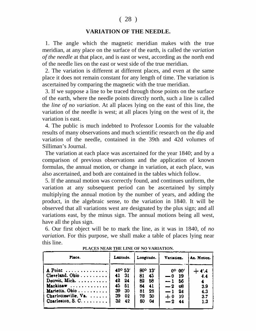
VARIATION OF THE NEEDLE.
1. The angle which the magnetic meridian makes with the truemeridian, at any place on the surface of the earth, is called the variationof the needle at that place, and is east or west, according as the north endof the needle lies on the east or west side of the true meridian. 2. The variation is different at different places, and even at the sameplace it does not remain constant for any length of time. The variation isascertained by comparing the magnetic with the true meridian. 3. If we suppose a line to be traced through those points on the surfaceof the earth, where the needle points directly north, such a line is calledthe line of no variation. At all places lying on the east of this line, thevariation of the needle is west; at all places lying on the west of it, thevariation is east. 4. The public is much indebted to Professor Loomis for the valuableresults of many observations and much scientific research on the dip andvariation of the needle, contained in the 39th and 42d volumes ofSilliman’s Journal. The variation at each place was ascertained for the year 1840; and by acomparison of previous observations and the application of knownformulas, the annual motion, or change in variation, at each place, wasalso ascertained, and both are contained in the tables which follow. 5. If the annual motion was correctly found, and continues uniform, thevariation at any subsequent period can be ascertained by simplymultiplying the annual motion by the number of years, and adding theproduct, in the algebraic sense, to the variation in 1840. It will beobserved that all variations west are designated by the plus sign; and allvariations east, by the minus sign. The annual motions being all west,have all the plus sign. 6. Our first object will be to mark the line, as it was in 1840, of novariation. For this purpose, we shall make a table of places lying nearthis line.
PLACES NEAR THE LINE OF NO VARIATION.
( 29 )
At the point whose latitude is 40° 53’, longitude 80° 13’, the variationof the needle was nothing in the year 1840, and the direction of the lineof no variation, traced north, was N. 24° 35’ west. The line of novariation, prolonged, passed a little to the east at Cleveland, in Ohio---the variation there being 19 minutes east. Detroit lay still further to thewest of this line, the variation there being 1° 56’ east; and Mackinawstill further to the west, as the variation at that place was 2° 08’ east. The course of the line of no variation, prolonged southerly, was S. 24°35’ E. Marietta, Ohio, was west of this line----the variation there being1° 24’ east. Charlottesville, in Virginia, was a little to the east of it----the variation there being 19’ west; whilst Charleston, in South Carolina,was on the west---the variation there being 2° 44’ east. From these results, it will be very easy see about where the line of novariation is traced in our own country. 7. We shall give two additional tables:
PLACES WHERE THE VARIATION WAS WEST.
PLACES WHERE THE VARIATION WAS EAST.
( 30 )METHODS OF ASCERTAINING THE VARIATION.
8. The best practical method of determining the true meridian of aplace, is by observing the north star. If this star were precisely at thepoint in which the axis of the earth, prolonged, pierces the heavens,then, the intersection of the vertical plane passing through it and theplace, with the surface of the earth, would be the true meridian. But thestar being at a distance from the pole equal to 1° 30’ nearly, it per-formsa revolution about the pole in a circle, the polar distance of which is 1°30’: the time of the revolution is 23 h. and 56 min. To the eye of the observer, this star is continually in motion, and is duenorth but twice in 23 h. 56 min.; and is then said to be on the meridian.Now, when it departs from the meridian, it apparently moves east orwest, for 5 h. and 59 min., and then returns to the meridian again. Whenat its greatest distance from the meridian, east or west, it is said to be atits greatest eastern or western elongation. The following tables show the times of its greatest eastern and westernelongations.
EASTERN ELONGATIONS.
WESTERN ELONGATIONS.
( 31 )
The eastern elongations are put down from the first of April to the firstof October; and the western, from the first of October to the first ofApril; the time is computed from 12 at noon. The western elongations inthe first case, and the eastern in the second, occurring in the daytime,cannot be used. Some of those put down are also invisible, occurring inthe evening, before it is dark, or after daylight in the morning. In suchcase, if it be necessary to determine the meridian at that particularseason of the year, let 5h. and 59 m. be added to, or subtracted from, thetime of greatest eastern or western elongation, and the observation bemade at night, when the star is on the meridian. 9. The following table exhibits the angle which the meridian planemakes with the vertical plane passing through the pole-star, when at itsgreatest eastern or western elongation: such angle is called the azimuth.The mean angle only is put down, being calculated for the first of Julyof each year:
AZIMUTH TABLE.
The use of the above tables, in finding the true meridian, will soonappear.
( 32 )TO FIND THE TRUE MERIDIAN WITH THE THEODOLITE.
10. Take a board, of about one foot square, paste white paper upon it,and perforate it through the centre: the diameter of the hole beingsomewhat larger than the diameter of the telescope of the theodolite.Let this board be so fixed to a vertical staff as to slide up and downfreely; and let a small piece of board, about three inches square, benailed to the lower edge of it, for the purpose of holding a candle. About twenty-five minutes before the time of the greatest eastern orwestern elongation of the pole-star as shown by the tables ofelongations, let the theodolite be placed at a convenient point andlevelled. Let the board be placed about one foot in front of thetheodolite, a lamp or candle placed on the shelf at its lower edge; and letthe board be slipped up or down, until the pole-star can be seen throughthe hole. The light reflected from the paper will show the cross hairs inthe telescope of the theodolite. Then, let the vertical spider’s line be brought exactly upon the pole-star, and, if it is an eastern elongation that is to be observed, and the starhas not reached the most easterly point, it will move from the linetowards the east, and the reverse when the elongation is west. At the time the star attains its greatest elongation, it will appear tocoincide with the vertical spider’s line for some time, and then leave it,in the direction contrary to its former motion. As the star moves towards the point of its greatest elongation, thetelescope must be continually directed to it, by means of the tangent-screw of the vernier plate; and when the star has attained its greatestelongation, great care should be taken that the instrument be notafterward moved. Now, if it be not convenient to leave the instrument in its place untildaylight, let a staff, with a candle or small lamp upon its upperextremity, be arranged at thirty or forty yards from the theodolite, and inthe same vertical plane with the axis of the telescope. This is easilyeffected, by revolving the vertical limb about its horizontal axis withoutmoving the vernier plate, and aligning the staff to coincide with thevertical hair. Then mark the point directly under the theodolite; the linepassing through this point and the staff, makes an angle with the truemeridian equal to the azimuth of the pole-star. From the table of azimuths, take the azimuth corresponding to the yearand nearest latitude. If the observed elongation was east, the truemeridian lies on the west of the line which has been found, and makes
( 33 )
with it an angle equal to the azimuth. If the elongation was west, the truemeridian lies on the east of the line; and, in either case, laying off theazimuth angle with the theodolite, gives the true meridian.
TO FIND THE TRUE MERIDIAN WITH THE COMPASS.
11. 1. Drive two posts firmly into the ground, in a line nearly east andwest; the uppermost ends, after the posts are driven, being about threefeet above the surface, and the posts about four feet apart: then lay aplank, or piece of timber three or four inches in width, and smooth onthe upper side, upon the posts, and let it be pinned or nailed, to hold itfirmly. 2. Prepare a piece of board four or five inches square, and smooth onthe under side. Let one of the compass-sights be placed at right angles tothe upper surface of the board, and let a nail be driven through theboard, so that it can be tacked to the timber resting on the posts. 3. At about twelve feet from the stakes, and in the direction of the pole-star, let a plumb be suspended from the top of an inclined stake or pole.The top of the pole should be of such a height that the pole star willappear about six inches below it; and the plumb should be swung in avessel of water to prevent it from vibrating. This being done, about twenty minutes before the time of elongation,place the board, to which the compass sight is fastened, on thehorizontal plank, and slide it east or west, until the aperture of thecompass-sight, the plumb-line, and the star, are brought into the samerange. Then if the star depart from the plumb-line, move the compass-sight east or west along the timber, as the case may be, until the starshall attain its greatest elongation, when it will continue behind theplumb-line for several minutes, and will then recede from it in thedirection contrary to its motion before it became stationary. Let thecompass-sight be now fastened to the horizontal plank. During thisobservation it will be necessary to have the plumb-line lighted: this maybe done by an assistant holding a candle near it. Let now a staff, with a candle or lamp upon it, be placed at a distanceof thirty or forty yards from the plumb-line, and in the same directionwith it and the compass-sight. The line so determined makes, with thetrue meridian, an angle equal to the azimuth of the pole-star; and fromthis line the variation of the needle is readily determined, even withouttracing the true meridian on the ground. Place the compass upon this line, turn the sights in the direction of it,and note the angle shown by the needle, Now, if the elongation, at
A---5
( 34 )
the time of observation, was west, and the north end of the needle is onthe west side of the line, the azimuth, plus the angle shown by theneedle, is the true variation. But should the north end of the needle befound on the east side of the line, the elongation being west, thedifference between the azimuth and the angle would show the variation,and the reverse when the elongation is east.
1. Elongation west, azimuth - - - - 2° 01’ North end of the needle on the west, angle - 4° 06’
________
Variation - - - 6° 10’ west________
2. Elongation west, azimuth - - - - 1° 59’ North end of the needle on the east, angle - 4° 50’
________Variation - - - 2° 51’ east
________
3. Elongation east, azimuth - - - - 2° 05’ North end of the needle on the west, angle - 8° 30’
________
Variation - - - 6° 25’ west________
4. Elongation west, azimuth - - - - 1° 57’ North end of the needle on the west, angle - 8° 40’
________
Variation - - - 10° 37’ east
Remark I. The variation at West point, in September, 1835, was 6° 32’west. Remark II. The variation of the needle should always be noted onevery survey made with the compass, and then if the land be surveyed ata future time, the old lines can always be re-run. 12. It has been found by observation, that heat and cold sensibly affectthe magnetic needle, and that the same needle will, at the same place,indicate different lines at different hours of the day. If the magnetic meridian be observed early in the morning, and again atdifferent hours of the day, it will be found that the needle will continueto recede from the meridian as the day advances, until about the time ofthe highest temperature, when it will begin to return, and at evening willmake the same line as in the morning. This change is called the diurnalvariation, and varies, during the summer season, from one-fourth toone-fifth of a degree.
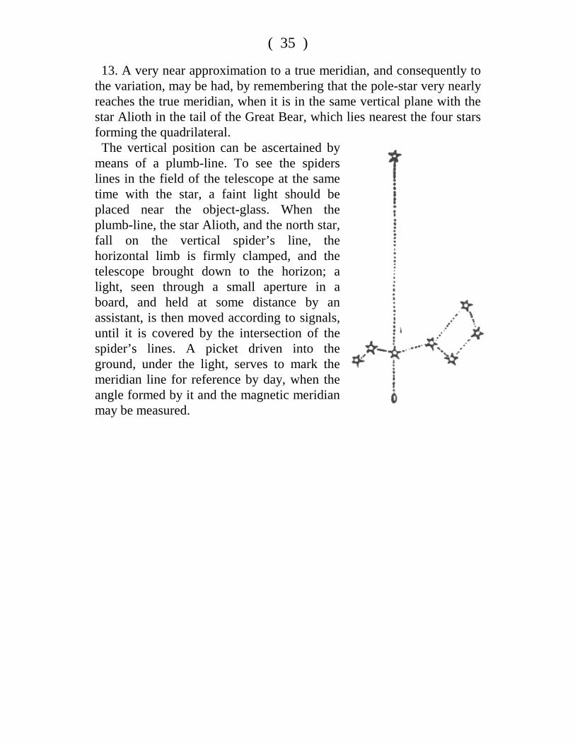
( 35 )
13. A very near approximation to a true meridian, and consequently tothe variation, may be had, by remembering that the pole-star very nearlyreaches the true meridian, when it is in the same vertical plane with thestar Alioth in the tail of the Great Bear, which lies nearest the four starsforming the quadrilateral. The vertical position can be ascertained bymeans of a plumb-line. To see the spiderslines in the field of the telescope at the sametime with the star, a faint light should beplaced near the object-glass. When theplumb-line, the star Alioth, and the north star,fall on the vertical spider’s line, thehorizontal limb is firmly clamped, and thetelescope brought down to the horizon; alight, seen through a small aperture in aboard, and held at some distance by anassistant, is then moved according to signals,until it is covered by the intersection of thespider’s lines. A picket driven into theground, under the light, serves to mark themeridian line for reference by day, when theangle formed by it and the magnetic meridianmay be measured.