A HISTORY & SELF-GUIDING TOUR OF SWAN ISLAND … isl tour bk 12.pdf · A HISTORY & SELF-GUIDING...
24
A HISTORY & SELF-GUIDING TOUR OF SWAN ISLAND SWAN ISLAND SWAN ISLAND SWAN ISLAND SWAN ISLAND 'An Island in Time' Maine Department of Inland Fisheries & Wildlife Wildlife Division 284 State Street Augusta, ME 04333-0041 www.mefishwildlife.com www.mefishwildlife.com www.mefishwildlife.com www.mefishwildlife.com www.mefishwildlife.com www.maine.gov/swanisland www.maine.gov/swanisland www.maine.gov/swanisland www.maine.gov/swanisland www.maine.gov/swanisland Wildlife History Hiking Camping Education Scenery
Transcript of A HISTORY & SELF-GUIDING TOUR OF SWAN ISLAND … isl tour bk 12.pdf · A HISTORY & SELF-GUIDING...

A HISTORY &
SELF-GUIDING
TOUR OF
SWAN ISLANDSWAN ISLANDSWAN ISLANDSWAN ISLANDSWAN ISLAND'An Island in Time'
Maine Department of Inland Fisheries & WildlifeWildlife Division284 State Street
Augusta, ME 04333-0041www.mefishwildlife.comwww.mefishwildlife.comwww.mefishwildlife.comwww.mefishwildlife.comwww.mefishwildlife.com
www.maine.gov/swanislandwww.maine.gov/swanislandwww.maine.gov/swanislandwww.maine.gov/swanislandwww.maine.gov/swanisland
Wildlife
History
Hiking
Camping
Education
Scenery

ACKNOWLEDGEMENTS
The Maine Department of Inland Fisheries and Wildlife wishes to extendits appreciation to Swan Island staff, whose efforts make your visit to theSteve Powell Wildlife Management Area an enjoyable and educationalevent.
Special thanks to 1977 island summer employees Edward Kennedy andDale Farrar, who were instrumental in the original preparation of thisbrochure; and to Hazel Reynolds and Brice Bond, 2008 ConservationAides that updated the text and maps in this booklet.
Photographs provided by Bill Silliker, Jr. @ www.camerahunter.comDick Bernier, Lisa Kane, Mark Latti and other MDIFW staff.
Further appreciation is expressed to all Maine sportsmen and the FederalAid to Wildlife Restoration Program, for financial support of wildlifemanagement programs on the Island. Without these funds, the wildlifeobserved here could not be maintained.
INDEX PAGEA Brief History 2-6Raptor Silhouettes 7Self Guiding Tour 8-20Animal Tracks 19
Revised - March 2012
www.maine.gov/swanisland

1
1 Tubbs-Reed House 2 Tubbs-Reed Barn 3 Sheds 4 Priest-Blen House 5 Machine Shop 6 Priest Buildings 7 Saunders-Underwood-Priest House 8 Turner-White House 9 Lewis House10 Foss-Perkins-Hibbard House11 Boathouse12 Gardiner-Dumaresq-Hibbard House13 Robinson-Powell House14 Day-Lewis House15 Curtis Cemetary16 Curtis House17 Curtis Barn18 Washington-Call House19 Schoolhouse20 Lewellen-Call House21 Tollman-Derrah House22 Lewis House23 Wade House24 Lilly-Wade House25 Lovett-Leavett-Consumer House26 Maxwell-Tarr House27 Jackson-Reed Barn28 Jackson-Reed House29 Unnamed cellar30 Barker-Harward House31 Theobald Barn32 Red camp33 Site of Deering Ice House34 Supposed Site of Whidden Stockade35 Charles Smith House36 Sarah Lilly House37 Site of Consumer Ice House
Road
Building Site
Building
Wild Rice
Freshwater Ponds
Historic Sites Map
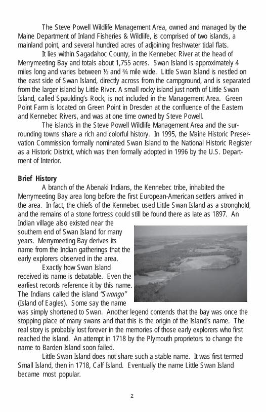
The Steve Powell Wildlife Management Area, owned and managed by theMaine Department of Inland Fisheries & Wildlife, is comprised of two islands, amainland point, and several hundred acres of adjoining freshwater tidal flats.
It lies within Sagadahoc County, in the Kennebec River at the head ofMerrymeeting Bay and totals about 1,755 acres. Swan Island is approximately 4miles long and varies between ½ and ¾ mile wide. Little Swan Island is nestled onthe east side of Swan Island, directly across from the campground, and is separatedfrom the larger island by Little River. A small rocky island just north of Little SwanIsland, called Spaulding’s Rock, is not included in the Management Area. GreenPoint Farm is located on Green Point in Dresden at the confluence of the Easternand Kennebec Rivers, and was at one time owned by Steve Powell.
The islands in the Steve Powell Wildlife Management Area and the sur-rounding towns share a rich and colorful history. In 1995, the Maine Historic Preser-vation Commission formally nominated Swan Island to the National Historic Registeras a Historic District, which was then formally adopted in 1996 by the U.S. Depart-ment of Interior.
Brief HistoryA branch of the Abenaki Indians, the Kennebec tribe, inhabited the
Merrymeeting Bay area long before the first European-American settlers arrived inthe area. In fact, the chiefs of the Kennebec used Little Swan Island as a stronghold,and the remains of a stone fortress could still be found there as late as 1897. AnIndian village also existed near thesouthern end of Swan Island for manyyears. Merrymeeting Bay derives itsname from the Indian gatherings that theearly explorers observed in the area.
Exactly how Swan Islandreceived its name is debatable. Even theearliest records reference it by this name.The Indians called the island “Swango”(Island of Eagles). Some say the namewas simply shortened to Swan. Another legend contends that the bay was once thestopping place of many swans and that this is the origin of the Island’s name. Thereal story is probably lost forever in the memories of those early explorers who firstreached the island. An attempt in 1718 by the Plymouth proprietors to change thename to Barden Island soon failed.
Little Swan Island does not share such a stable name. It was first termedSmall Island, then in 1718, Calf Island. Eventually the name Little Swan Islandbecame most popular.
2

3
The first recorded visit of European-American explorers to Swan Islandcame in 1607 when members of the Popham Colony stopped at the island. A secondvisit occurred in 1614 when Captain John Smith visited the Kennebec Indians on theIsland.
The next record of European-American settlers in connection with SwanIsland occurred in 1667 when Christopher Lawson bought the island from the IndianChief Abbagadasett. Lawson built a house and lived on Swan Island. In 1668,Lawson used Swan Island as collateral for a loan from wealthy Boston merchantHumphry Davy. Four years later, in 1672, Lawson defaulted on the loan and trans-ferred title of Swan Island to Davy. The Indian, or Frontier Wars, occurred during
1676-1759, severely affecting the settlement of Swan Island and the surroundingregion. The next record of colonists actually living on Swan Island is in 1730, when aThomas Percy homesteaded there. No further mention of the Percy family is re-corded. In 1750, the only family living on the island was the Whidden family.
On September 8, 1750, Indians attacked the house of Captain JamesWhidden. The Whiddens escaped by hiding in the cellar. However their two sons,daughter (Abigail Noble) and her husband (Lazarus Noble), along with their sevenchildren and two servants, were captured. The Indians took the captives up theKennebec River to Quebec, Canada, where they sold them as slaves to the French.The adults fetched $29 each, while the children went for next to nothing.
The youngest Noble child (Frances) was adopted by a young Frenchcouple, and was baptized as Eleanor in a Catholic church and given a conventeducation. Later, government agents found the girl, and despite her desire to remainwith her foster parents, she was returned to Swan Island at age 13. Upon her return,she found her mother died and her father in poverty. Frances later became a teacher.Other members of the family also returned to Swan Island.
Salt Box
Despite the Indian problems, Swan Island continued to attract colonists.Between 1758 and 1763, Dr. Sylvester Gardiner built the Dumaresq or “salt box”house. This house was a wedding present for his newly married daughter (Rebecca)and her husband (Philip Dumaresq). In 1775, Benedict Arnold’s expedition jour-neyed up the Kennebec River on their way to attack Quebec. It is reported thatBenedict Arnold, Aaron Burr and General Henry Dearborn stayed a night in theDumaresq house. According to legend, while on the island, Aaron Burr met an Indianprincess, Jacataqua, who accompanied him to Canada and later to New York. WhenBurr shot Alexander Hamilton in a very controversial duel, Jacataqua became soupset that she threw herself from Hell’s Gate into the East River, NY.
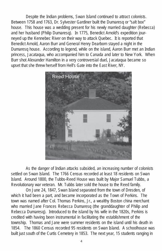
As the danger of Indian attacks subsided, an increasing number of colonistssettled on Swan Island. The 1766 Census recorded at least 18 residents on SwanIsland. Around 1800, the Tubbs-Reed House was built by Major Samuel Tubbs, aRevolutionary war veteran. Mr. Tubbs later sold the house to the Reed family.
On June 24, 1847, Swan Island separated from the town of Dresden, ofwhich it had been a part, and became incorporated as the Town of Perkins. Thetown was named after Col. Thomas Perkins, Jr., a wealthy Boston china merchantwho married Jane Frances Rebecca Dumaresq (the granddaughter of Philip andRebecca Dumaresq). Introduced to the island by his wife in the 1820s, Perkins iscredited with having been instrumental in facilitating the establishment of thetownship. Thomas and Jane were summer residents on the island until his death in1854. The 1860 Census recorded 95 residents on Swan Island. A schoolhouse wasbuilt just south of the Curtis Cemetery in 1853. The next year, 15 students ranging in
4
Reed House
5
age from 4 to 20 years enrolled. The building was occasionally used for religiousservices and town meetings. A road, the Perkins Highway, was developed in 1879 tolink the south end of the island with the ferry landing in the north. The course of thepresent road generally follows the Perkins Highway.
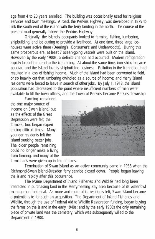
Originally, the island’s occupants looked to farming, fishing, lumbering,shipbuilding, and ice cutting to provide a livelihood. At one time, three large ice-houses were active there (Deering’s, Consumer’s and Underwood’s). During thissame prosperous era, at least 7 ocean-going vessels were built on the island.However, by the early 1900s, a definite change had occurred. Modern refrigerationrapidly brought an end to the ice cutting. At about the same time, iron ships becamepopular, and the Island lost its shipbuilding business. Pollution in the Kennebec hadresulted in a loss of fishing income. Much of the island had been converted to field,or so heavily cut that lumbering dwindled as a source of income; and many Islandresidents were forced to leave in search of other jobs. By July 1, 1918, the islandpopulation had decreased to the point where insufficient numbers of men wereavailable to fill the town offices, and the Town of Perkins became Perkins Township.
Farming remainedthe one major source ofincome on Swan Island, butas the effects of the GreatDepression were felt, thefarmers, too, began experi-encing difficult times. Manyyounger residents left theisland seeking better jobs.The older people remainingcould no longer make a livingfrom farming, and many of thefarmsteads were given up in lieu of taxes.
Termination of Swan Island as an active community came in 1936 when theRichmond-Swan Island-Dresden ferry service closed down. People began leavingthe island rapidly after this occurrence.
The Maine Department of Inland Fisheries and Wildlife had long beeninterested in purchasing land in the Merrymeeting Bay area because of its waterfowlmanagement potential. As more and more of its residents left, Swan Island becamea potential site for such an acquisition. The Department of Inland Fisheries andWildlife, through the use of Federal Aid to Wildlife Restoration funding, began buyingthe farms on the Island in the early 1940s; and by the early 1950s the only remainingpiece of private land was the cemetery, which was subsequently willed to theDepartment in 1988.

6
Swan Island soon became Swan Island Game Management Area. One ofthe early biologists working and living there was Stephen E. Powell. When Powell leftthe Island, he became responsible for all the Wildlife Management Areas in the state.At this time, he donated a strip of land in the Kennebec River adjacent to the SwanIsland Game Management Area. This area, known as the “Middle Ground”, is a veryvaluable feeding area for migrating ducks and geese. After Steve Powell’s death in1971, the name of the area was changed, in his memory, to Steve Powell WildlifeManagement Area.
When Swan Island first became a Wildlife Management Area, there wereinitial plans to use it primarily as an experimental site for various wildlife manage-ment activities. There is still one large fenced enclosure on the island, which wasused in testing various types of deer repellents. The experimental plans for theisland were gradually dropped as the University of Maine at Orono became betterequipped to handle such work. Today, management on the Island is directed tobenefit migrating waterfowl, grassland birds and a diverse array of other wildlife.Monies derived from an excise tax on firearms and ammunition, (Pittman-RobertsonAct), fund this management.
With 5 to 7 foot freshwater tides, nesting bald eagles, numerous white-taileddeer, wild turkeys, and 3,000 to 4,000 visitors each year, Swan Island is truly unique.Steve Powell Wildlife Management Area (WMA) provides a sanctuary for migratingwaterfowl, turkeys, and the resident white-tailed deer. It is also the only WMA in thestate where camping is allowed and information and education programs areprovided for visitors. The value of the historical sites here further enhances theuniqueness of this area.
Dick Bernier

7
ButeosBROAD WINGS AND BROAD ROUNDED TAILS; OFTEN SEEN SOARING IN WIDECIRCLES HIGH IN THE AIR.Examples: Red-tailed Hawk, Broad-winged Hawk
FalconsSTREAMLINED-LONG POINTED WINGS; LONGISH COMPRESSED TAPERED TAILS;STRONG ROWING WING BEATS; LOSE SOME OF THEIR POINTED WING ANDTAPERED TAIL LOOK WHEN NOT IN DIRECT FLIGHT.Examples: Peregrine Falcon, Kestrel
AccipitersSHORT, WIDE, ROUNDED WINGS; LONG TAILS; FLAP, FLAP, FLAP-SAIL FLIGHT.
Examples: Goshawk, Sharp-shinned hawk, Cooper's hawk
Identifying Raptors in Flight

8
SELF GUIDING TOUR
9
Introduction
This self-guided tour is organized to run from the northern end of SwanIsland along the gravel road to the southern tip. Each major feature discussed isrepresented at the site by a numbered metal sign, which corresponds to the num-bered location on the Self-Guiding Tour map. Unfortunately, the houses are notopen to the public due to lack of staffing and supervision for visitors.
1. WELL There are many hand-dug wells on the Island. For your safety, thewells have been secured by capping and/or enclosed with fencing.
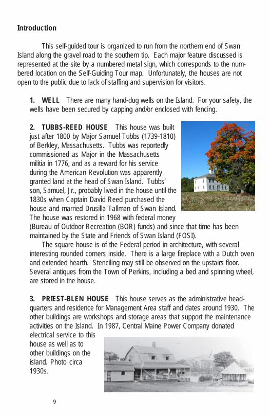
2. TUBBS-REED HOUSE This house was builtjust after 1800 by Major Samuel Tubbs (1739-1810)of Berkley, Massachusetts. Tubbs was reportedlycommissioned as Major in the Massachusettsmilitia in 1776, and as a reward for his serviceduring the American Revolution was apparentlygranted land at the head of Swan Island. Tubbs’son, Samuel, Jr., probably lived in the house until the1830s when Captain David Reed purchased thehouse and married Drusilla Tallman of Swan Island.The house was restored in 1968 with federal money(Bureau of Outdoor Recreation (BOR) funds) and since that time has beenmaintained by the State and Friends of Swan Island (FOSI).
The square house is of the Federal period in architecture, with severalinteresting rounded corners inside. There is a large fireplace with a Dutch ovenand extended hearth. Stenciling may still be observed on the upstairs floor.Several antiques from the Town of Perkins, including a bed and spinning wheel,are stored in the house.
3. PRIEST-BLEN HOUSE This house serves as the administrative head-quarters and residence for Management Area staff and dates around 1930. Theother buildings are workshops and storage areas that support the maintenanceactivities on the Island. In 1987, Central Maine Power Company donatedelectrical service to thishouse as well as toother buildings on theisland. Photo circa1930s.

10
4. CAMPGROUND The campground was built in 1966 with help from a legisla-tive grant. Ten Adirondack shelters hold up to 6 people each, providing a fullcapacity of 60 overnight campers. Water is provided for all campers. The bath-room facility was completed in 2006 and provides modern conveniences for Islandvisitors.
5. WHITE OAK Acorns of the whiteoak are much less bitter than those ofred oak. The Indians ground theseacorns to make crude flour. Note thatthe leaves of white oak are more evenlyrounded and smoothly lobed than thoseof the more common red oak. This isabout the northern edge of the range ofthe white oak in Maine
6. NATURE TRAILS The Maine Conservation Corps (MCC) began constructionof the nature trail system in 1985. It now consists of 3 separate trails. The BeaverPond Trail is approximately ½ mile long and encompasses a variety of habitat types,including a managed field and man made pond. The West Side Trail is approxi-mately 3 miles long and runs through the wooded portion of the western interior sideof the Island. The East Side Trail is a short loop that originates at the campground,follows the thoroughfare between the Island and Little Swan Island, and winds up atthe Curtis Cemetary.
7. LITTLE SWAN ISLAND This Island is located just off the east-shore of SwanIsland, across from the campground. Just less than 30 acres in size, Little SwanIsland is heavily wooded. There are no standing buildings on Little Swan Island.Once headquarters of the Kennebec Indian chief, this island is part of the WMA. Noactive management occurs on the island at this time, allowing continued preserva-tion of potential archaeological sites for future work.
The small island located just off the north tip of Little Swan Island isSpaulding’s Rock. This Rock is named for an English lady, Ann Spaulding, whocame to Swan Island to marry a colonist. Upon her arrival she found the man of herdreams had “jumped the gun” and married someone else. As a result, AnnSpaulding chose to live alone on Spaulding’s Rock.
8. GARDINER-DUMARESQ HOUSE The Gardiner-Dumaresq House is oftencalled the “salt box” because of its architectural design. Dr. Sylvester Gardiner builtthe house between 1758 and 1763 as a summer residence for his daughterRebecca (b.1745) and her husband Philip Dumaresq (1737-1800). It is not known

11
how much time these Boston residents spenton the island, but after the American Revolu-tion, Philip (a loyalist) was sent into exile inthe West Indies. According to RobertHallowell Gardiner, Rebecca and Philip’sson, James Dumaresq (b.1772) exchangedsome land bequeathed to him in Pittston forthe Swan Island farm that his grandfatherhad left to his uncle John Sylvester Gardiner. Although the land was described asbeing “very good”, James apparently did little farming, preferring instead to hunt andvisit his cousin Robert Hallowell upriver at the Oaklands estate in Gardiner. Return-ing to Swan Island after one such visit in the autumn of 1826, James’ boat struck a“flaw” and he drowned. After James’ death, his son Philip Dumaresq and sister JaneFrances Rebecca Perkins appear to have used the property at Swan Island exclu-sively as a summer residence. In 1855, Philip’s wife Margaretta Deblois, daughterFrances, and a friend drowned while swimming in Little River. Philip (a ship cap-tain), was subsequently lost overboard and drowned in Long Island Sound, NY onJune 25, 1861. Dr. E.C. Hebbard of Boston purchased the Gardiner-Dumaresqproperty in 1900. The State of Maine purchased the property from Ida M. Hebbard inthe 1940s. It was restored in 1968 with federal money (BOR funds) and has beenmaintained by the State and Friends of Swan Island (FOSI) since that time.
The brown boathouse at the river’s edge is estimated to be over 100 years old,and is used for wildlife and conservation education programming and teacherworkshops during the open season.
9. ROBINSON-POWELL HOUSE This house was built sometime during the1880s. James Alvin Robinson (b.1862) appears in the 1880 Census of Perkins as afarmer. The 1893 Census lists Robinson as being a fisherman. In 1910 he was a48-year-old carpenter/boat builder.
Summer employees occasionally live in this house. There is a phone here incase of emergencies. Stephen E. Powell, the original biologist on Swan Island,resided here with his wife for many years.
10. MAN MADE POND This isone of 8 man made ponds on theisland. If you look closely you willsee several wooden boxes ontrees, several feet above the water.These are wood duck nesting

12
boxes. Other waterfowl species which may use these boxes include commongoldeneyes and hooded mergansers.
The wood duck approached extinction in the early 1930s. As a result ofrestrictive hunting regulations and the installation of thousands of nesting boxesstatewide by the Department of Inland Fisheries and Wildlife and other privateorganizations, the wood duck is now one of the most abundant ducks in Maine.The male wood duck is one of the most beautiful birds in the world, and itsfeathers are very valuable for fly tying. It is a favorite among hunters and wildlifewatchers for its taste and exquisiteness.
11. BLACK BIRCH An extract from the inner bark of this species is used tomake birch beer. Green twigs can be chewed, taste like wintergreen, and havebeen called “Indian toothbrush”.
12. CURTIS CEMETERY Traditionally, Maine families had separate burialareas. Thus it was on Swan Island untilBen Curtis suggested putting all thegraves in one spot. All but one familymoved their graves (see Call Cemetery).The Curtis Cemetery was the onlyprivately owned land left on the islanduntil 1988, when it was willed to theDepartment. Descendants of familieswho once lived on Swan Island retainburial rights to the Curtis Cemetery.Headstones date from 1802 to 1968.
13. CALL CEMETERY The 1766 Census claims that the Call family ownedproperty on Swan Island at the turn of the 18th century. Census records from 1850indicate there was a population of 84 people at the time, and makes a reference toa Peleg Call, listed as a brick-maker, and a George Call, listed as a carpenter. In1900, the Census lists the population at 95 and makes reference to a L.R. Call,listed as a merchant. There are no headstones visible that would indicate these 3individuals were buried on the Island. Several headstones exist from the Callfamily. Those headstones date from 1822-1864.
14. GRASSLAND BIRD MANAGEMENT Historically, most of northeasternNorth America was forested. Natural, permanent grasslands were uncommon. Bythe 1880s grasslands were widespread as land was cleared for pastures andhayfields. Grassland birds undoubtedly benefited from this by providing habitat for
13
the grasshopper sparrow, savannah sparrow,vesper sparrow, upland sandpiper, easternmeadowlark, eastern bluebird, and bobolink.However, early 20th century agriculture,technology, increases in human populationsand movement of farms to the Midwest andwest caused a decline in the quantity andquality of grasslands for wildlife. Today,maintaining grasslands is a common wildlifemanagement tool to provide habitat for manydeclining bird species. Traditionally all fieldswere mowed once or twice each summer.This helped the clover and timothy to grow well and provided Canada geese andWild Turkeys with preferred low foraging grasses. Today, mowing continues, butis done in such a way as to maintain a variety of grassland types and heights tobest optimize use by grassland birds, waterfowl and turkeys. All Island fields aremowed on a rotating basis every 1-3 years.
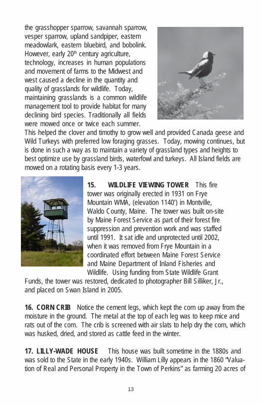
15. WILDLIFE VIEWING TOWER This firetower was originally erected in 1931 on FryeMountain WMA, (elevation 1140’) in Montville,Waldo County, Maine. The tower was built on-siteby Maine Forest Service as part of their forest firesuppression and prevention work and was staffeduntil 1991. It sat idle and unprotected until 2002,when it was removed from Frye Mountain in acoordinated effort between Maine Forest Serviceand Maine Department of Inland Fisheries andWildlife. Using funding from State Wildlife Grant
Funds, the tower was restored, dedicated to photographer Bill Silliker, Jr.,and placed on Swan Island in 2005.
16. CORN CRIB Notice the cement legs, which kept the corn up away from themoisture in the ground. The metal at the top of each leg was to keep mice andrats out of the corn. The crib is screened with air slats to help dry the corn, whichwas husked, dried, and stored as cattle feed in the winter.
17. LILLY-WADE HOUSE This house was built sometime in the 1880s andwas sold to the State in the early 1940s. William Lilly appears in the 1860 “Valua-tion of Real and Personal Property in the Town of Perkins” as farming 20 acres of

14
land and owning one cow. In the 1860 Census, Lilly is listed as a 38-year-oldhouse joiner. Joseph Wade, a river fisherman, is thought to have lived in the houseduring the first decade of the 20th century. The State and the Swan Island Projectof the Richmond School District currently maintain the house.
18. EXPERIMENTAL DEER EXCLOSURE When Swan Island first became aWildlife Management Area in the middle 1940s, this wire exclosure was built forexperiments with various types of deer repellents. As you pass by the fenced 4 acreplot, please notice the number and variety of trees and shrubs growing inside.
When you get to the end of thefence, compare what you seeinside with what is growingoutside the fence. This will giveyou some idea of what deer eatand the effects of having toomany deer in one area.
Deer numbers in the moresettled portions of the Staterapidly decreased duringcolonial times as a result of very
intensive farming, timber harvesting and uncontrolled hunting. Deer populationlevels in these areas remained very low until extensive farmland abandonmentafter 1880 created ideal deer habitat. In addition, a closed deer hunting seasonwas established in Cumberland, Knox, Lincoln, Waldo, York, Sagadahoc,Androscoggin, and Kennebec counties in the 1890s. Deer became more abun-dant by the turn of the century, and deer seasons were established in all previouslyclosed counties by 1903.
Although Sagadahoc County was again opened to deer hunting, Swan Islandwas apparently never reopened to the legal harvesting of deer. Legislative actionin 1929 (P.L. Chapter 77) resulted in the lawful declaration of Swan Island as aGame Preserve, making itunlawful to hunt, chase, trap, kill,or pursue any wild animals orbirds on either Swan Island orLittle Swan Island, known collec-tively as Perkins Township.
During the early 1900s,human habitation on Swan Islanddecreased due to a combinationof social and economic factors.This resulted in an assortment of

15
reverting farm and mixed growthforest, which provided ideal habitat fordeer. Favorable habitat conditions,coupled with the prohibition ofhunting on the area, resulted in asubstantial increase in deer. Thelatter habitat changes were similar tothat which occurred throughout muchof the central and coastal portions ofthe State, and were responsible forthe upswing in the overall deernumbers in these areas.Initial deer management and research efforts on Swan Island included: animalrepellent studies, limited forest cuttings, trapping and removing surplus deer in aneffort to control damage to crops planted primarily for goose management.Records indicate that from 1947 through 1957, 364 deer were trapped, tagged,and relocated. However, this deer removal had no significant long-term impact onthe size of the island deer population, and the habitat continues to decrease inquality. Deer swim across and walk over on river ice. Trapping after 1957 waslimited to a few animals for research at the University of Maine at Orono.
In an effort to control the deer population, the Department of Inland Fisheriesand Wildlife proposed an experimental 3 day hunting season on Swan Island in theearly 1950s. However, overwhelming public sentiment against the proposal at apublic hearing in Richmond defeated the proposal.
Very high deer population levels continued to be a common occurrence in thearea through the 1960s and 1970s (200-300 animals). With the arrival of thecoyote to Maine, the reduction of winter feeding in the early 1980s and the lack ofwinter browse, deer numbers on the island have decreased and appear to havestabilized for the time being.
Average winters in this portion of Maine enable deer on the island to do limitedground pawing for acorns, etc.; however, prolonged periods of deep snow and/orcrusty conditions eliminate this means of food gathering. Continuous over-utilization of winter browse has resulted in little or no woody material available asan alternate food source. Local game wardens and biologists report that manydeer will cross the frozen river daily to feed on the mainland. Domestic dogs andcoyotes often kill deer along the treacherous shore ice, which rarely stays snowcovered in winter due to flooding at each high tide. Why deer return and attempt towinter on the Island is not clearly understood. In all likelihood it is in response tothe availability of sheltered conditions, which are not present on the adjacentmainland.
16
Legislative action in 1969 repealed the public law, which constituted thegame preserve section relating to Swan Island. This placed all Departmentowned refuges under the classification of Wildlife Management Areas andgranted the commissioner the power to regulate and control seasons and baglimits on these areas. The Steve Powell Wildlife Management Area (Swan Island)is currently the only Wildlife Management Area where all public hunting isprohibited.
As we have seen, the deer on Swan Island have not been subjected to anyform of controlled harvests for approximately 100 years. The results of thisprotection of the deer population are typical of areas regulated for prolongedperiods as game sanctuaries. Populations expand beyond the carrying capacityof their habitat, and the majority of the browse producing plants (food) are com-pletely destroyed or severely stunted. On Swan Island, even the less palatablefoods (i.e., white pine and alder) show extremely over-browsed conditions.Timber cutting conducted to stimulate browse production (see SelectivelyHarvested Area) accomplished little, since sprout and seedling growth arequickly consumed and not given enough time to become established.
Future management of Swan Island may include additional timber harvestsand a return to farming practices to increase food availability for both deer andwaterfowl. The Department may also consider annual hunting seasons as amethod to help maintain deer numbers at a level in harmony with existing habitatand conditions.
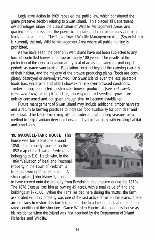
19. MAXWELL-TARR HOUSE Thishouse was built sometime around1850. The property appears on the1852 map of the Town of Perkins asbelonging to E.C. Hatch who, in the1860 “Valuation of Real and PersonalProperty in the Town of Perkins”, islisted as owning 44 acres of land. Aship captain, John Maxwell, appearsto have moved onto the property from Bowdoinham sometime during the 1870s.The 1878 Census lists him as owning 49 acres, with a total value of land andbuildings at $775.00. When the Tarrs resided here during the 1920s, the farmassociated with this property was one of the last active farms on the island. Thereare no plans to restore this building further, due to a lack of funds and the deterio-rated condition of the structure. Game Warden Higgins also used this house ashis residence when the Island was first acquired by the Department of InlandFisheries and Wildlife.
17
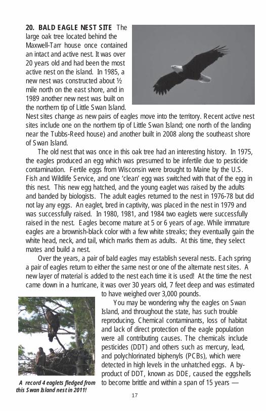
20. BALD EAGLE NEST SITE Thelarge oak tree located behind theMaxwell-Tarr house once containedan intact and active nest. It was over20 years old and had been the mostactive nest on the island. In 1985, anew nest was constructed about ½mile north on the east shore, and in1989 another new nest was built onthe northern tip of Little Swan Island.Nest sites change as new pairs of eagles move into the territory. Recent active nestsites include one on the northern tip of Little Swan Island; one north of the landingnear the Tubbs-Reed house) and another built in 2008 along the southeast shoreof Swan Island.
The old nest that was once in this oak tree had an interesting history. In 1975,the eagles produced an egg which was presumed to be infertile due to pesticidecontamination. Fertile eggs from Wisconsin were brought to Maine by the U.S.Fish and Wildlife Service, and one ‘clean’ egg was switched with that of the egg inthis nest. This new egg hatched, and the young eaglet was raised by the adultsand banded by biologists. The adult eagles returned to the nest in 1976-78 but didnot lay any eggs. An eaglet, bred in captivity, was placed in the nest in 1979 andwas successfully raised. In 1980, 1981, and 1984 two eaglets were successfullyraised in the nest. Eagles become mature at 5 or 6 years of age. While immatureeagles are a brownish-black color with a few white streaks; they eventually gain thewhite head, neck, and tail, which marks them as adults. At this time, they selectmates and build a nest.
Over the years, a pair of bald eagles may establish several nests. Each springa pair of eagles return to either the same nest or one of the alternate nest sites. Anew layer of material is added to the nest each time it is used! At the time the nestcame down in a hurricane, it was over 30 years old, 7 feet deep and was estimated
to have weighed over 3,000 pounds.You may be wondering why the eagles on Swan
Island, and throughout the state, has such troublereproducing. Chemical contaminants, loss of habitatand lack of direct protection of the eagle populationwere all contributing causes. The chemicals includepesticides (DDT) and others such as mercury, lead,and polychlorinated biphenyls (PCBs), which weredetected in high levels in the unhatched eggs. A by-product of DDT, known as DDE, caused the eggshellsto become brittle and within a span of 15 years —A record 4 eaglets fledged from
this Swan Island nest in 2011!

18
between the end of World War II and the 1960s — the population of bald eaglesplummeted. These chemical contaminants dramatically increase in concentrationas they travel through the food chain in each successively larger predator. Conse-quently, bald eagles receive large doses of the pesticides from feeding upon fish. Adrastic decline in bald eagle reproduction occurred because of this.
Looking at the bright side, the status of the bald eagle in Maine has signifi-cantly improved as a result of banning DDT, reduction of river pollution, andprotection and management of eagle habitats and nesting areas.
Today, bald eagle nest sites across Maine are designated as “EssentialHabitats”, and are subject to protection standards under the recently updatedMaine’s Endangered Species Act (2007). We are encouraged by a steady long-term trend of bald eagle population growth. This recovery was acknowledged bydowngrades from a status of Endangered to Threatened across the lower 48 statesin 1995; and removal from the Threatened List in 2007. The Maine legislaturesimilarly reclassified bald eagles to a Threatened Species under State law in 1996;and in 2009 eagles were removed entirely from the Maine Endangered SpeciesList. Numbers of breeding pairs of eagles increased to a high of over 600 here in2011 compared to 56 in 1980, while total productivity increased from 40 to close to500 eaglets.
21. GRAVEL PIT The gravel from this pit provides the material needed to main-tain the road, an integral part of the overallisland maintenance program.
22. TROUT POND This pond is thedeepest on the Island, and is periodicallystocked with brown trout by IF&W’s HatcheryDivision. It is a designated “Kids Water”, openonly to fishing for kids under 16 under theGeneral Law.
23. MIDDLE GROUND The strip of green freshwater tidal flat extending down thecenter of the river is called the “middle ground”. At low tide, it amounts to about 20acres of very productive feeding area for ducks, geese, and a variety of shorebirds.
Steve Powell owned the middle ground, but in the early 1950s, when he left theisland to become head of the Wildlife Management Areas in the State, he donatedthe middle ground to the Wildlife Management Area.
Green Point Farm adjoins the middle ground to the north. This 432 acreparcel of land lies at the confluence of the Eastern and Kennebec Rivers inDresden. Green Point was sold to the State (in conjunction with The NatureConservancy) by Steve Powell’s nephew, Robert Gleason, in 1999, becoming themost recent addition to the nearby Merrymeeting Bay Wildlife Management Area.
19
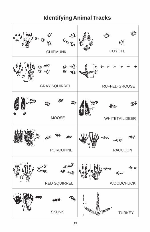
TURKEY
WOODCHUCK
PORCUPINE
RED SQUIRREL
RACCOON
WHITETAIL DEERMOOSE
GRAY SQUIRREL RUFFED GROUSE
CHIPMUNK COYOTE
SKUNK
Identifying Animal Tracks

24. WHIDDEN HOUSE HISTORY In 1750, a house near this end of the Islandbelonged to the Whidden family. Mr. & Mrs. Whidden, their daughter and herhusband (Mr. & Mrs. Noble), seven children, and two servants lived here. Readtheir story in the Brief History section in the front of this booklet.
25. SWEET FERN The leaves of this plant may be boiled to make tea, put in asmall bag (sachet) to scent clothes, or crushed and rubbed on poison ivy to speedthe healing. It is also a favorite deer food.
26. THEOBALD POINT This is the end of the road, you’ve travelled about 4miles; and are standing at Theobald Point. If you look south, down the KennebecRiver, you will see the power lines from the now decommissioned Maine YankeeAtomic Power plant in Wiscasset crossing the river to Bowdoinham. Directlyacross the river is a former skeet range and hunting camp.
You are overlooking a portion of Merrymeeting Bay, which contains approxi-mately 9,000 acres and is fed by 6 different rivers – the Kennebec, Androscoggin,Eastern, Cathance, Abbagadasett, and Muddy. The name of the Bay may originatefrom the confluence of rivers as a meeting and harvesting area by the Abenaki.With the river inflows and twice daily tidal turnover of nutrients, the Bay is one of therichest and most productive estuarine habitats on the east coast. Most of the lightgreen vegetation in the water is wild rice, a favorite food of ducks and geese. Wildrice is one of only 2 cereal crops native to North America. (The other is maize, orcorn.) The darker green vegetation is mostly bulrush. The wild rice grows through-out the summer until it is well above the water even at high tide. It ripens inSeptember and provides food for many waterfowl and other bird species.
WE HOPE YOU ENJOYED THE TOUR AND COME BACK AGAIN!
20

FIELD NOTES
Reservations are not required for those using a personalcanoe/kayak to access the island.
Please put admission fee into Iron Rangers at island dock or campground.To make Swan Island camping or ferry reservations, call 207-547-5322
Monday-Friday; or email [email protected]
www.maine.gov/swanisland
'Like' uson Facebook!
Open daily, 9:30 am-4:30 pm mid-April through November 11.Open daily, 9:30 am-4:30 pm mid-April through November 11.Open daily, 9:30 am-4:30 pm mid-April through November 11.Open daily, 9:30 am-4:30 pm mid-April through November 11.Open daily, 9:30 am-4:30 pm mid-April through November 11.
A 200-acre park with 30A 200-acre park with 30A 200-acre park with 30A 200-acre park with 30A 200-acre park with 30different species of wildlifedifferent species of wildlifedifferent species of wildlifedifferent species of wildlifedifferent species of wildlife
on exhibit.on exhibit.on exhibit.on exhibit.on exhibit.
Route 26, Gray
Loon Plates Do Great Things For Maine!Loon Plates Do Great Things For Maine!Loon Plates Do Great Things For Maine!Loon Plates Do Great Things For Maine!Loon Plates Do Great Things For Maine!*You'll help fund important wildlife conservation efforts and state parks*You'll help fund important wildlife conservation efforts and state parks*You'll help fund important wildlife conservation efforts and state parks*You'll help fund important wildlife conservation efforts and state parks*You'll help fund important wildlife conservation efforts and state parks*It makes Maine eligible for significant Federal Matching Funds to support*It makes Maine eligible for significant Federal Matching Funds to support*It makes Maine eligible for significant Federal Matching Funds to support*It makes Maine eligible for significant Federal Matching Funds to support*It makes Maine eligible for significant Federal Matching Funds to support wildlife conservation wildlife conservation wildlife conservation wildlife conservation wildlife conservation*Your contributions help make improvements to Maine's parks and lands*Your contributions help make improvements to Maine's parks and lands*Your contributions help make improvements to Maine's parks and lands*Your contributions help make improvements to Maine's parks and lands*Your contributions help make improvements to Maine's parks and lands*You'll qualify for an annual tax deduction of $14*You'll qualify for an annual tax deduction of $14*You'll qualify for an annual tax deduction of $14*You'll qualify for an annual tax deduction of $14*You'll qualify for an annual tax deduction of $14*You'll grace your car or truck with the nicest looking license plate anywhere!*You'll grace your car or truck with the nicest looking license plate anywhere!*You'll grace your car or truck with the nicest looking license plate anywhere!*You'll grace your car or truck with the nicest looking license plate anywhere!*You'll grace your car or truck with the nicest looking license plate anywhere!
The Loon License Plate is available at Bureau of Motor Vehicles,The Loon License Plate is available at Bureau of Motor Vehicles,The Loon License Plate is available at Bureau of Motor Vehicles,The Loon License Plate is available at Bureau of Motor Vehicles,The Loon License Plate is available at Bureau of Motor Vehicles, town offices and online at www.myloonplate.com town offices and online at www.myloonplate.com town offices and online at www.myloonplate.com town offices and online at www.myloonplate.com town offices and online at www.myloonplate.com
Moose, black bear,Moose, black bear,Moose, black bear,Moose, black bear,Moose, black bear,white-tailed deer, fisher, lynx,white-tailed deer, fisher, lynx,white-tailed deer, fisher, lynx,white-tailed deer, fisher, lynx,white-tailed deer, fisher, lynx,bobcat, mountain lions, baldbobcat, mountain lions, baldbobcat, mountain lions, baldbobcat, mountain lions, baldbobcat, mountain lions, bald
eagles, trophy trout, wild turkeyseagles, trophy trout, wild turkeyseagles, trophy trout, wild turkeyseagles, trophy trout, wild turkeyseagles, trophy trout, wild turkeys& more!& more!& more!& more!& more!
www.myloonplate.com
www.Mainewildlifepark.com
Admission feesAdmission feesAdmission feesAdmission feesAdmission feesNo reservations required!No reservations required!No reservations required!No reservations required!No reservations required!
Plenty of free parkingPlenty of free parkingPlenty of free parkingPlenty of free parkingPlenty of free parkingBring a picnic and spend the dayBring a picnic and spend the dayBring a picnic and spend the dayBring a picnic and spend the dayBring a picnic and spend the day
For more information,For more information,For more information,For more information,For more information,please callplease callplease callplease callplease call
207-657-4977 or207-657-4977 or207-657-4977 or207-657-4977 or207-657-4977 or207-287-8000207-287-8000207-287-8000207-287-8000207-287-8000