A historical and social perspective of a signifi cant but ...
30
A historical and social perspective of a significant but little-known suburb of Adelaide. S t M a r y s w a l k b r o c h u r e S t M a r y s w a l k b r o c h u r e
Transcript of A historical and social perspective of a signifi cant but ...

A historical and social perspective of a signifi cant but little-known suburb of Adelaide.
St Marys walk brochure
St Marys walk brochure
walk brochure red.indd p3 29/09/2003, 9:29:38 AM

S t
M
a r
y s
W
A L
K
ST MARYS HERITAGE WALK Introduction This brochure has been prepared to allow the community to enjoy a pleasant walk and discover the history of the suburb of St Marys.
A fold-out map is provided inside the back cover of the brochure and the numbers on the map refer to the features described in the following pages. The St Marys Heritage Walk starts and fi nishes at St Marys Anglican Church car park, 1167 South Road.
PLEASE NOTE: The walk can be divided into two parts, the fi rst part fi nishing at St Marys Reserve (No. 10) and walking back to South Road and the church car park. The second part of the walk can be continued from St Marys Reserve at a later time.
The walk is disable friendly, however re-routing along adjacent streets may be necessary at some reserves. St Marys is on a gentle slope and suitable for most walkers.
walk brochure red.indd p6 29/09/2003, 9:29:52 AM

S t M a r y s W
A L K
1
History of St Marys St Marys was fi rst settled in the late 1830s by the Daw and Ayliffe families. Over the next twenty years they were joined by Benjamin Babbage, explorer and amateur scientist, and Captain William O’Halloran.
Robert Richard Torrens, of the Torrens Title land ownership fame, owned a large parcel of land in the middle part of St Marys. John Daw donated one acre for the establishment of the St Marys Church of England, thought to be named after the St Mary’s Abbott’s Parish Church in Kensington, England. The general area became known as St Marys-on-the-Sturt, as there were no buildings between the church and the Sturt River, about 3 kms south.
The suburb became an important agricultural area for Adelaide with wheat and hay being grown. As crop-growing moved to the northern area of the colony, some of the fi elds were replanted with almonds, vines and olives.
It was after the First World War that the agricultural landscape of St Marys began to change. In the early to mid-1920s there was a land boom due to the increasing use of the motor car. Motor vehicles became affordable and allowed people to become more mobile and live further away from their work places.
View of St Marys towards South Road, 1909
walk brochure red.indd 1 29/09/2003, 9:29:53 AM

S t
M
a r
y s
W
A L
K
2
As a result of the decreasing use of the horse, landowners sold their hay paddocks for housing development. Owning one’s home and block of land came within reach of a larger section of the population.
Various subdivisions such as St Marys Park, Castle Estate, Clovelly Gardens and South Road Estate were planned. Development was slow due to the effects of the Great Depression and the Second World War. In 1949 there were only about 25 residents living in St Marys. After the Second World War the State Government encouraged expansion of the industrial sector. This resulted in the establishment in the 1950s of the Chrysler Car assembly plant (now Mitsubishi) opposite St Marys at Tonsley Park (now part of Clovelly Park). This encouraged support industries to be developed in St Marys. The South Australian Housing Trust bought unsold blocks to provide affordable housing for the workers.
Despite ongoing suburban and industrial development there are still some surviving traces indicating St Marys agricultural heritage. This brochure will give the walker a historical and social perspective of a signifi cant but little-known suburb of Adelaide, indicating its evolution from a colonial village to a 20th century metropolitan suburb.
‘it is hoped that you will enjoy
your walk’
walk brochure red.indd 2 29/09/2003, 9:29:53 AM

S t M a r y s W
A L K
3
St Marys Heritage WalkDistance: approx. 8 km
1 St Marys Anglican Church and Cemetery
1167 South Road
The present church was built in 1847 on land donated by John Wickham Daw. History records that the stone used for the building was quarried from land owned by the Ayliffe family (Ayliffes Road was originally the driveway from South Road to their property). In the early 1870s the tower, surmounted by a battlement was added. The burial records show that the fi rst person interred at the cemetery in 1847 was James Penn, a descendant of William Penn, founder of the colony of Pennsylvania in America in 1682. The church and cemetery were consecrated by Bishop Augustus Short in 1849. Early pioneers and settlers are buried in the cemetery.
The original St Marys Church was erected in 1841 about 250 metres north of the present church (by the St Marys Fire Station, see No. 5). The original church was made of stringy-bark with a shingled roof and was the third Church of England to be built in South Australia. The other two were Holy Trinity on North Terrace, Adelaide and St Paul’s in Port Adelaide. The church began to deteriorate and was unfi t for services. It was used as a schoolroom until it was demolished in 1928.
In August 1981 the title of the ‘Church of England’ was changed to the ‘Anglican Church of Australia’.
Visitors are permitted to enter the church property and inspect the church building and cemetery. There is a cemetery walk booklet available from the church.
MA 00:02:8 ,9002/80/903 ddni.der eruhcorb klaw

S t
M
a r
y s
W
A L
K
4
2 Shops, northern side of St Marys Church
Various shops have been established adjacent to the northern end of the church grounds since the 1850s. Unfortunately none of the original buildings remain.
3 North-west area of St MarysThis land was originally owned by John Wickham Daw, one of the fi rst settlers in the district. Daw subdivided the South Road frontage of his property as St Marys Village and built a smaller house on the corner of what was to become South Road and Daws Road (see No. 6). The house and several hundred acres were sold to Benjamin Herschel Babbage (1815-1878) in 1852. Babbage, the fi rst Chairman of the Mitcham District Council, had a keen, enquiring mind and was an accomplished engineer and surveyor, having worked under Isambard Kingdom Brunel in England. Babbage supervised the building of the Adelaide to Port Adelaide Railway for the South Australian Government, and was responsible for the assaying of gold from the Victorian goldfi elds.
St Marys Church, 1932
walk brochure red.indd 4 29/09/2003, 9:29:54 AM

S t M a r y s W
A L K
5
Babbage also undertook exploration for the Colonial Government. He was also instrumental in debunking the myth of a horse-shoe shaped “great salt lake” to the north of Port Augusta, preventing further access to the interior. His explorations assisted John McDouall Stuart to pioneer his epic journey from Adelaide to the coast of Northern Territory in 1862. Babbage named St Marys Peak in the Flinders Ranges after his home area. He was a fi rm supporter and lay preacher for the St Marys Church of England.
At St Marys, Babbage experimented in various agricultural pursuits including the growing of vines, olives, citrus orchards and roses. He cultivated some new varieties of roses, some of which are still growing in the Adelaide Botanical Gardens. Because of the profusion of roses in his garden, Babbage’s property became known as ‘The Rosary’.
After Babbage’s original home burnt down in 1875, he built a grand mansion that was known throughout the region as ‘Babbage’s castle’. Babbage experimented with cement as a new building material, but unfortunately he used salty water, and as soon as it was built, the ‘castle’ started crumbling. The last of the Babbage family left the estate in 1896.
Benjamin Herschel Babbage
walk brochure red.indd 5 29/09/2003, 9:29:55 AM

S t
M
a r
y s
W
A L
K
6
During the Great Depression of the1930s, the ruins of Babbage’s ‘castle’ provided a refuge for homeless families. The Adelaide Development Company acquired the land in 1936 and created the Castle Estate subdivision. William (Bill) Brookman Watson (1888-1940) became the salesman for the area. Watson, known for his initiative, sold blocks of land to visiting Royal Navy sailors as unusual souvenirs of the British Empire.
Benjamin Babbage’s ‘castle’
The grounds of Babbage’s estate
walk brochure red.indd 6 29/09/2003, 9:29:57 AM

S t M a r y s W
A L K
7
Pinn Street was named after Elizabeth Magdalena Therese Pinn, the mother-in-law of Bill Watson. Her name provided several more street names for the original subdivision.
Benjamin Street was named after Benjamin Babbage. The street is shown in a map of Babbage’s property drawn by Babbage himself in 1863.
4 Gum TreesBenjamin Street
These few gum trees on the eastern side are surviving remnants of the trees planted by Babbage on his estate.
Kiana Street was named after a railway siding near Mt Hope on the Eyre Peninsula.
5 PlaqueOutside St Marys Fire Station
This plaque, dedicated in 1991 by the Anglican Archbishop of Adelaide, commemorates the opening of the fi rst St Marys Church of England in 1841 at this location.
The ruins of Babbage’s ‘castle’
walk brochure red.indd 7 29/09/2003, 9:29:59 AM

S t
M
a r
y s
W
A L
K
8
6 Site of Bill Watson’s residenceSouth-east cnr of South Road and Daws Road
Now a commercial site, Bill Watson updated a surviving home of the Daw family on this site, making it his residence. After Watson died the house was taken over by Dr Lloyd, the local G.P.
Bill Watson’s residence, corner of South Road and Daws Roads
William (Bill) and his wife Sarah Julia Watson
walk brochure red.indd 8 29/09/2003, 9:30:01 AM

S t M a r y s W
A L K
9
Daws Road was named after the pioneer settler in the area, John Wickham Daw.
Daws Road, 1948
John Wickham Daw and his family
walk brochure red.indd 9 29/09/2003, 9:30:01 AM

S t
M
a r
y s
W
A L
K
10
Along the southern side of Daws Road there are many conventional-style houses built from the 1950s onwards.
7 Olive TreeNo. 6 Donald Street
The olive tree in this front garden is one of many planted by Babbage in the 1860s, making it about 140 years old. During the Great Depression of the 1930s, people collected the olives from the surviving trees and bagged them to sell at various markets.
Up to the 1950s there were paddocks and open ground from the northern end of Dorene Street to Quinlan Avenue. In spring most of St Marys was a carpet of blue and purple due to the profusion of Salvation Jane.
8 No. 8a Southern Avenue This is a well-preserved example of a conventional gable-fronted house. The original owner built the shed fi rst and lived in it whilst building the house, which he fi nished in 1958.
No. 8a Southern Avenue
walk brochure red.indd 10 29/09/2003, 9:30:02 AM

S t M a r y s W
A L K
11
Drainage ReservesSpringfi eld Creek ran from the foothills and caused problems during heavy rain by fl ooding this part of St Marys. To fi x the problem the creek was covered by drainage pipes in the early 1970s by the owners of the land, the City of Mitcham. Babbage planted many European trees in his estate such as pine, pomegranate and mulberry which were watered by this creek. The trees lasted into the 1930s but were gradually cleared as the subdivision grew.
No. 18 Donald StreetA former Jehovah’s Witnesses Kingdom Hall converted into a residence.
9 Donald Street ReserveThe street art on the boundary fence facing Donald Street was a Youth Art Project initiated by the City of Mitcham in the 1980s.
Donald Street was to be called Clare Street when this subdivision was planned, after William Dysart Clare who married Ada Babbage, daughter of Benjamin Babbage. In the plans submitted to the Lands Title Offi ce in 1929 this was changed to the current name of Donald Street.
The fi rst part of the walk can be fi nished here – turn into Rothesay Avenue and walk back to South Road and the church car park.
walk brochure red.indd 11 29/09/2003, 9:30:03 AM

S t
M
a r
y s
W
A L
K
12
10 St Marys ReserveThe name of this reserve should not be confused with St Marys Park (see No. 18). Both Donald Street Reserve and St Marys Reserve were drawn in the original subdivision plan submitted to the Lands Title Offi ce in 1929. From St Marys Reserve you have a good view of the Hills Face Zone.
Mingbool Avenue - named after the town in the south-east of South Australia.
The junction of St Marys Street at Mingbool Avenue is wider than normal to accommodate the underground drainage of Springfi eld Creek fl owing through this part of St Marys. You can see the open creek at Marschall Boulevard in Pasadena.
11 ShopsCorner Thurles Street and Merriton Avenue
These shops were built in 1957 by Reginald Harvey-Crowson, a local builder who lived in Dorene Street. A grocer, butcher and delicatessen were based here. Shops were dotted throughout most suburbs in the days when car ownership was not as extensive as it is now. Since the 1960s large shopping malls and 24-hour service stations have taken over the role of delicatessens. This has meant that shops such as these are mostly vacant or are being used by small to medium businesses as offi ces to escape high rental costs in or near the Adelaide city centre.
walk brochure red.indd 12 29/09/2003, 9:30:03 AM

S t M a r y s W
A L K
13
12 Thurles Street ReserveThis reserve was developed by John Sutherland and other residents of the area in the 1950s.
Park Road – named as such as it borders the reserve.
Styles Avenue was named after George Styles, an Unley Road storekeeper and baker who took a keen interest in local affairs and was a member of the fi rst Mitcham District Council in 1853. He was born in Buckinghamshire, England and came to South Australia in 1849 and settled in Unley. He was a Justice of the Peace and often sat in the Police Court in Adelaide.
Julia Avenue was named after Sarah Julia Watson, wife of Bill Watson.
Norman Street was named after William Ashley Norman who was elected to the Mitcham District Council in 1921 and became the fi rst Mayor when Mitcham was proclaimed a City in 1947. He published a history of the City of Mitcham in 1953.
13 Nos. 16 & 18 Auricchio AvenueNo. 16 Auricchio Avenue is a genuine bungalow, a popular home style in the 1920s. No.18 is an example of “mass produced” units, built in the 1960s as the result of the introduction of a new Planning Act and zoning regulations to assist low-income families.
Auricchio Avenue was named after Mario Auricchio, who was an early member of the Fascio Italian Club, joining in 1927. He then decided to form a separate club independent of the Fascist community, named Vittorio Veneto Club after the battle that had become symbolic of Italy’s First World War victory. He worked
walk brochure red.indd 13 29/09/2003, 9:30:03 AM

S t
M
a r
y s
W
A L
K
14
for Bill Watson as a land salesman. Owing to fi nancial diffi culties of the Vittorio Veneto Club, Auricchio and some of his main supporters were forced to leave Adelaide.
14 Ragless ReserveJunction of The Crescent and Auricchio Avenue
The huge gum tree at this junction is a remnant of pre-subdivision vegetation in St Marys.
The Ragless family owned the ‘Tonsley’ estate from 1869 which included what is now the Mitsubishi car factory and straddled South Road to include part of St Marys. In 1841 this land was originally settled by Henry Watts calling his estate ‘Fiddown’. He was South Australia’s fi rst Postmaster General. Some of the St Marys land was sold to land salesman Bill Watson in 1925 for suburban development, creating the South Road Estate. Ragless Reserve was set aside from the outset. In 1964 the Watiparinga Creek, which openly fl owed through the reserve, was covered as part of the South West Drainage Scheme. The reserve was used as a camping and caravan ground run by the South Road Progress Association. At the northern end of the reserve a bridge, built in the 1850s, allowed traffi c on South Road to pass over the creek. In the mid-1960s when the road was widened the bridge was buried and is still underneath the road today. As early as 1844 the Ayliffe family quarried stone from the land in Pasadena to build South Road between Ayliffes Road and Daws Road.
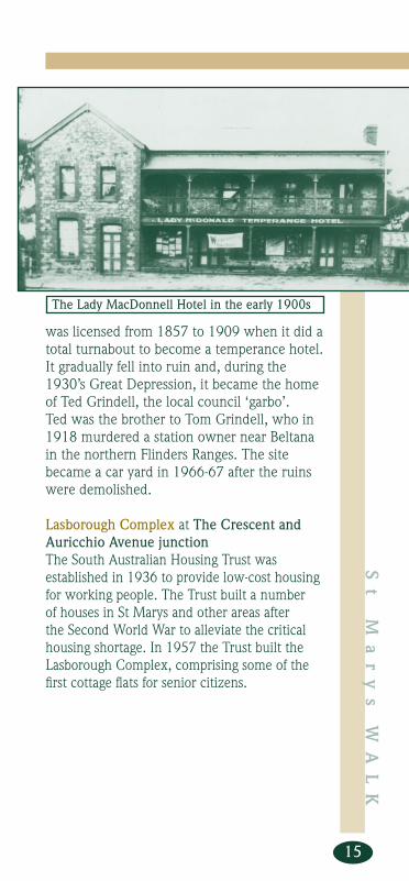
Looking south from Ragless Reserve, the former Lady MacDonnell Hotel was located at the corner of South Road and Ayliffes Road. The hotel was named after an 1850’s South Australian Governor, Sir R. G. MacDonnell. A sign-writer of the times misspelt the name and it became the Lady MacDonald. The hotel
walk brochure red.indd 14 29/09/2003, 9:30:03 AM
S t M a r y s W
A L K
15
was licensed from 1857 to 1909 when it did a total turnabout to become a temperance hotel. It gradually fell into ruin and, during the 1930’s Great Depression, it became the home of Ted Grindell, the local council ‘garbo’. Ted was the brother to Tom Grindell, who in 1918 murdered a station owner near Beltana in the northern Flinders Ranges. The site became a car yard in 1966-67 after the ruins were demolished.
Lasborough Complex at The Crescent and Auricchio Avenue junctionThe South Australian Housing Trust was established in 1936 to provide low-cost housing for working people. The Trust built a number of houses in St Marys and other areas after the Second World War to alleviate the critical housing shortage. In 1957 the Trust built the Lasborough Complex, comprising some of the fi rst cottage fl ats for senior citizens.
The Lady MacDonnell Hotel in the early 1900s
walk brochure red.indd 15 29/09/2003, 9:30:04 AM

S t
M
a r
y s
W
A L
K
16
15 Nos. 1 and 3 The CrescentThese homes are good examples of the Austerity building style. During and after the Second World War there were not enough materials to build big, decorative homes. Cement blocks and asbestos were some of the alternative materials used. Some Austerity-style homes were built as late as 1955. The houses were usually small consisting of two bedrooms, sitting and dining rooms and kitchen. Over time, owners added extra rooms.
16 Former South Adelaide Football ClubroomsCorner South Road and Brookman Avenue
This building was opened in 1973 by the then South Australian Transport Minister, the Hon. Geoff Virgo, as clubrooms for the South Adelaide Football Club. The Club moved to Noarlunga in 1995. (see No. 18 for more information on the Club).
Brookman Avenue was named after William (Bill) Brookman Watson who subdivided this area.
walk brochure red.indd 16 29/09/2003, 9:30:05 AM

S t M a r y s W
A L K
17
17 Flats ‘Brookman Court’Corner of Brookman and Laura Avenues.
These fl ats are another example of affordable 1960’s fl ats.
18 St Marys ParkLaura Avenue
This park was opened in 1929 as the South Road Recreation Ground. Swag men camped here in a shed during the Great Depression of the 1930s. The South Adelaide Football Club (The Panthers), established in 1875 as South Australia’s second oldest club, made this park its home ground in 1969. In 1971 the ground was offi cially opened as Panther Park, with a celebratory game played between South Adelaide and the 1970 Victorian Football League premiership champions Carlton -
The opening of the South Road Recreation Ground, 1929
Brookman Court
walk brochure red.indd 17 29/09/2003, 9:30:05 AM

S t
M
a r
y s
W
A L
K
18
Carlton won the game. The change rooms were built in the same year and named the ‘Dan Moriarty Rooms’ in memory of the famous Panther player who won three successive Magarey Medals, 1919-1921. In 1997 the reserve was renamed St Marys Park as the South Adelaide Football Club had moved to Noarlunga in 1995.
Laura Avenue The original name of Laura Avenue was Lortha however, over time, the name was corrupted to Laura. “Lortha” was reputedly the name of the Quinlan family property in Western Australia.
19 Shop18 Quinlan Avenue
This red brick shop and house was built in the 1920s to service the new subdivision of the South Road Estate and surrounding community. An unoffi cial Post Offi ce was established on South Road in 1927. In 1952 the Post Offi ce combined with the shop. In 1975 the Post Offi ce services were discontinued here and moved to the purpose-built Post Offi ce built at 1189 South Road in 1964.
Quinlan Avenue was named after Timothy Quinlan. Timothy married Sarah Julia Pinn in Western Australia. He died in 1919 in Perth whereupon Sarah went to Sydney and met her second husband, Bill Watson. They moved to Adelaide where Bill became a land salesman.
Dorene Street was named after Dorene Ann Kiley, wife of Denis Kiley. He bought the middle part of St Marys from Charles Cobb Ragless. In 1924 the land was subdivided and named Clovelly Gardens during a housing boom following the First World War.
walk brochure red.indd 18 29/09/2003, 9:30:05 AM

S t M a r y s W
A L K
19
20 No. 5 Lloyd StreetNo. 5 Lloyd Street is an original sandstone-fronted 1920’s bungalow. It was the home of the Reeves family who for many years delivered milk in the area by horse and cart.
Lloyd Street was named after another land salesman employed by Bill Watson.
No. 5 Lloyd Street
Quinlan Avenue, 1920s
walk brochure red.indd 19 29/09/2003, 9:30:05 AM

S t
M
a r
y s
W
A L
K
20
21 St Bernadette’s School OvalCorner South Road and Walsh Avenue
The four gum trees along the boundary of the oval are the last remnant of a double row planted along South Road in the 1880s by the Ragless family. They were planted as a result of a push by the Colonial Government of the day to encourage land holders to counter previous over-clearing.
22 St Bernadette’s Primary School (Catholic)54 Ragless Street
St Bernadette’s Primary School was opened in 1952 and was the third Dominican School to be established in the City of Mitcham area. Initially classes of 27 students were held in a transportable wooden unit. The school was staffed by Dominican Sisters. In 1976 the fi rst lay-principal was appointed. The church building was damaged by fi re lit by arsonists in 1990 and again in 1997, while the original school building was a target of arsonists in June 2000.
Ragless Street was named after the previous owner of the land, Charles Cobb Ragless whose family had settled in the district in 1869.
Charles C Ragless 1858-1945
walk brochure red.indd 20 29/09/2003, 9:30:08 AM

S t M a r y s W
A L K
21
23 St Marys Baptist Church5 Crystal Avenue
This church was built in 1965, exhibiting the typical triangular shape of church architecture of that period. It was in 1953 that Baptist worshippers in the suburb applied for fellowship in the Baptist Union, forming the St Marys Congregation. The fi rst church building (now demolished) was an iron and timber building that was moved from Underdale and rebuilt in St Marys on the northern side of the present church. The church operated a kindergarten as a community service between 1953 and 1981.
The area from here to St Marys Anglican Church was a trotting track from the 1930s until the land was developed in the 1950s. This was the subdivision of ‘Clovelly Gardens’ (see No. 19 Dorene Street). Like other subdivisions in the area, it took years for the land to be built on due to the Great Depression and the Second World War. The housing blocks in this subdivision were purchased by the South Australian Housing Trust, and Kiley Reserve, shown in the plan of the subdivision, became the South Road Primary School (see No. 26).
walk brochure red.indd 21 29/09/2003, 9:30:10 AM

S t
M
a r
y s
W
A L
K
22
24 Corner Crystal Avenue & Bailey StreetThe prefabricated house on this corner and other similar houses that you see on this walk were built by the South Australian Housing Trust. The City of Mitcham had a strong heritage in stone and prided itself with advocating solid stone houses. It was only after the Second World War during a period of severe housing shortage that the Housing Trust commenced building homes in the Mitcham Council area. By 1960 nearly 400 brick or timber-framed Housing Trust homes were built in St Marys.
25 North-east corner Merriton Avenue and Dorene Street
The small rose garden at this location is maintained by the City of Mitcham.
Examples of new mini-subdivisions which have taken place since the 1980s can be seen along Merriton Avenue to the west of Dorene Street and in Kiley Court.
Merriton Avenue – named after the town in mid-north South Australia where the Kiley family had farmed.
St Marys Close billboard, former South Road School site, November 1999
walk brochure red.indd 22 29/09/2003, 9:30:10 AM

S t M a r y s W
A L K
23
26 Site of South Road Primary SchoolDorene Street
This site was originally laid out as Kiley Reserve on the Clovelly Gardens subdivision plan. It was not developed.
In the 1920s the Darlington Motorcycle Club held races here, and later it was used as a training trotting track.
The Darlington Motorcycle Club in action at Clovelly Gardens, 1920s
Extract of the Clovelly Gardens subdivision plan showing Kiley Reserve, 1921-1923
walk brochure red.indd 23 29/09/2003, 9:30:11 AM

S t
M
a r
y s
W
A L
K
24
The land was taken up by the State Government for the South Road Primary School which opened in 1951.
In 1954 a Junior Primary (Infant) School was established adjacent to the Primary School buildings. In 1980, due to declining student enrolments, the Junior Primary School buildings were sold to the Edwardstown Baptist Church and the students were incorporated into the Primary School proper. The entire school was closed in 1997 and the land put up for sale by the State Government. The Edwardstown Baptist Church bought the land and buildings, fi nancing their expansion through the sale of some of the land for housing blocks in Kiley Court in 1998.
27 ReserveRothesay Avenue
Kiley Court and the Reserve were once the South Road Primary School oval and sporting grounds (see No. 26). Kiley Court, Denis Street and Thurles Street were named by Denis Kiley, son of an Irish immigrant labourer from Thurles, County Tipperary. Denis subdivided this area of St Marys.
Rothesay Avenue was named after the Duke of Rothesay (c.1378 – 1402), only surviving son of Robert III of Scotland. He was confi ned in the dungeon of Strathlyrum Castle for reasons unknown, and either starved to death or died of dysentery on 27 March, 1402. The title is still used by the Prince of Wales.
Cashel Street was named after the Rock of Cashel (meaning circular) located near Thurles in Tipperary, Ireland.
A short walk along South Road will take you back to St Marys Church.
walk brochure red.indd 24 29/09/2003, 9:30:11 AM

Sout
h R
oad
walk brochure red.indd p4 29/09/2003, 9:29:47 AM

walk brochure red.indd p5 29/09/2003, 9:29:52 AM

1
your notes and observations
fold out for location map
walk brochure red.indd p1 29/09/2003, 9:29:27 AM
This brochure is proudly provided
by the
City of Mitcham131 Belair Road
Torrens Park SA 5062
Phone : (08) 8372 8888Facsimile (08) 8372 8101
www.mitchamcouncil.sa.gov.au
Mitcham HeritageResearch CentreMitcham Cultural Village
103-105 Princes RoadMitcham
Phone: (08) 8372 8261
© Text Mike Somerset 2003
Map concept Maggy Ragless, Community Historian,
City of Mitcham 2009
‘Proud of our
history and
committed to
our future’
The Mitcham Heritage Research Centre houses the Local History Collection and is supported by the City of Mitcham. A Community Historian works with a voluntary support team and aims to:
* maintain and promote the unique heritage and history of the City of Mitcham
* promote public access to heritage material in a convenient and friendly atmosphere
* encourage the community to explore and discover the history of the district
* continue primary source research about the district’s past* express the results of research through a variety of ways
Compiled by Mike Somerset and Maggy Ragless, Mitcham Community Historian, 2003.
MA 00:81:8 ,9002/80/902p ddni.der eruhcorb klaw
Facsimile (08) 8372 8109


![Poly(propylene) Nanocomposites Containing Various Carbon ...composites.utk.edu/papers in pdf/Li_et_al-2011... · [2 , 6 , 27–32 ] In particular, signifi - cant property enhancements](https://static.fdocuments.net/doc/165x107/600d48ee6e7d8e397d689796/polypropylene-nanocomposites-containing-various-carbon-in-pdflietal-2011.jpg)