a. Historic and Archeological Resources
34
Appendix 2.5 Historic and Archaeological Resources
Transcript of a. Historic and Archeological Resources
Appendix 2.5 Historic and Archaeological Resources


NeversinkReservoirNeversinkReservoir Rondout
ReservoirRondoutReservoir
Ashokan ReservoirAshokan Reservoir
West BranchReservoirWest BranchReservoir
Croton FallsReservoir
Croton FallsReservoir
New CrotonReservoir
New CrotonReservoir
KensicoReservoir
KensicoReservoir
HU
DS
ON
RIV
ER
HU
DS
ON
RIV
ER
Ulster
Sullivan
Orange
Litc
hfiel
d
Dutchess
Fairfield
Sussex
Westchester
Putnam
Rockland
Columbia
Bergen
Passaic
Greene
Catskill State Park
Harriman State Park
High Point State Park
Wawayanda State Park
Clarence FahnestockMemorial State Park
MinnewaskaState Park
Taconic State Park
NE
W Y
OR
KC
ON
NE
CT
I CU
T
N E W Y O R K
N E W J E R S E Y
44
9W
44
44
9W209
206
202
9
9
9
7
7
1
684
84
84
87
87
TACO
NIC
STAT
E PA
RKW
AY
Poughkeepsie
Beacon
Peekskill
Newburgh
MarlboroPlattekill
Ellenville
Kingston
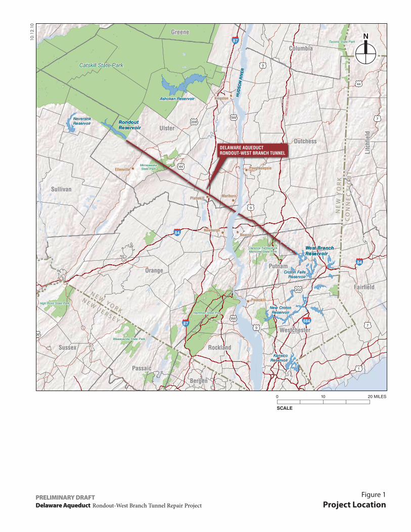
DELAWARE AQUEDUCTRONDOUT-WEST BRANCH TUNNEL
10.12.10
Delaware Aqueduct Rondout-West Branch Tunnel Repair Project
Figure 1
Project LocationPRELIMINARY DRAFT
SCALE
0 10 20 MILES
Project Site
Study Area Boundary (400-Foot Perimeter)
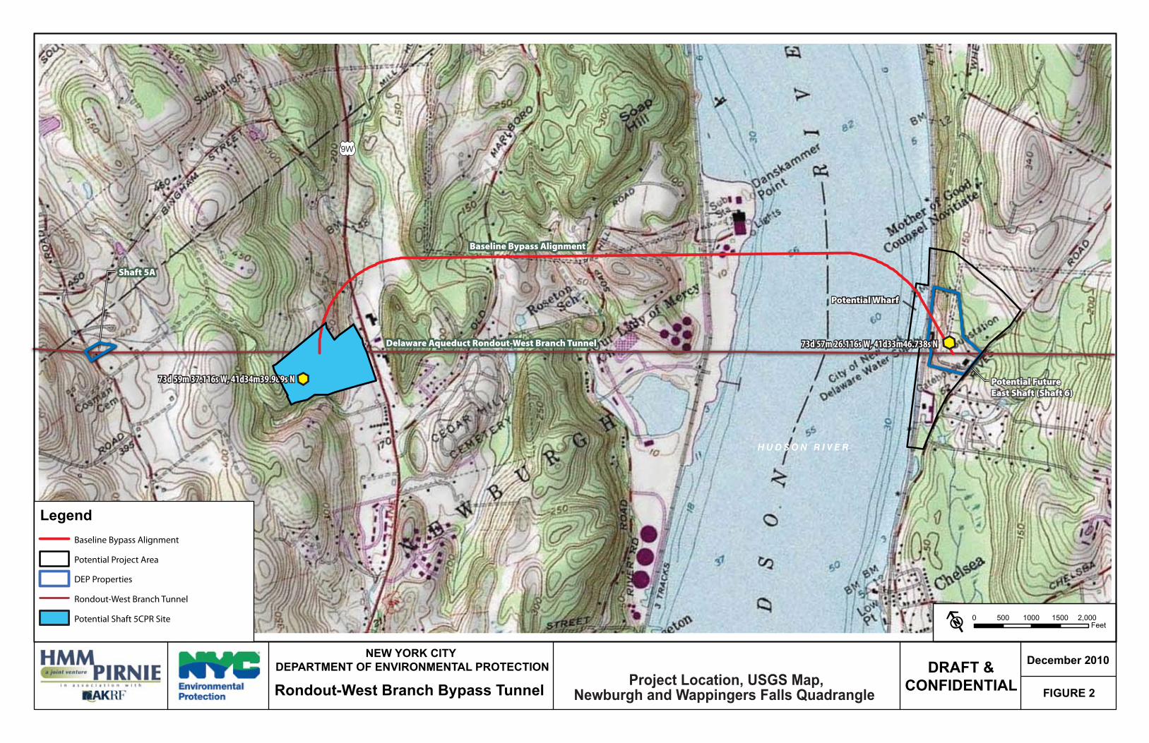
9W
Baseline Bypass Alignment
Delaware Aqueduct Rondout-West Branch Tunnel
Shaft 5A
Potential FutureEast Shaft (Shaft 6)
Potential Wharf
H U D S O N R I V E R
73d 59m 37.116s W, 41d34m39.989s N
73d 57m 26.116s W, 41d33m46.738s N
0 500 1000 1500 2,000Feet
FIGURE 2
December 2010DRAFT &CONFIDENTIALProject Location, USGS Map,
Newburgh and Wappingers Falls Quadrangle
NEW YORK CITY DEPARTMENT OF ENVIRONMENTAL PROTECTION
Rondout-West Branch Bypass Tunnel
LegendBaseline Bypass Alignment
Potential Project Area
DEP Properties
Rondout-West Branch Tunnel
Potential Shaft 5CPR Site
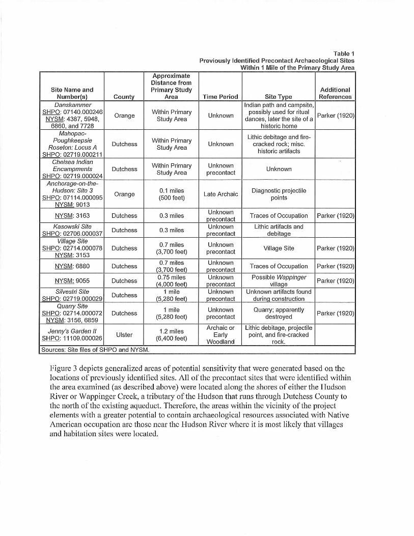
DanskammerPoint
ChelseaRoseton
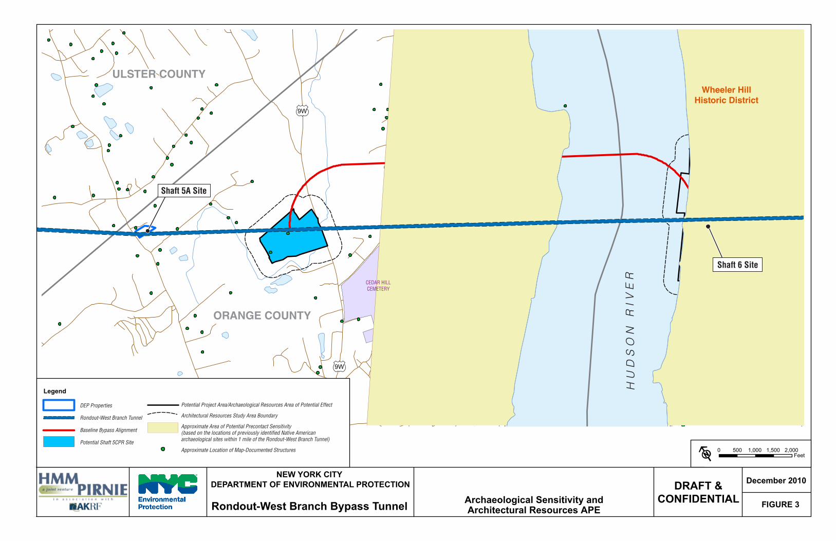
ULSTER COUNTY
ORANGE COUNTY
DUTCHESS COUNTY
HU
DS
ON
RIV
ER
9W
9W
CEDAR HILLCEMETERY
Shaft 5A Site
Shaft 6 Site
Wheeler HillHistoric District
NEW YORK CITY DEPARTMENT OF ENVIRONMENTAL PROTECTION
FIGURE 3
December 2010DRAFT &CONFIDENTIALArchaeological Sensitivity and
Architectural Resources APERondout-West Branch Bypass Tunnel
0 500 1,000 1,500 2,000Feet
Legend
DEP Properties
Rondout-West Branch Tunnel
Baseline Bypass Alignment
Potential Shaft 5CPR Site
Potential Project Area/Archaeological Resources Area of Potential Effect
Architectural Resources Study Area Boundary
Approximate Area of Potential Precontact Sensitivity(based on the locations of previously identified Native Americanarchaeological sites within 1 mile of the Rondout-West Branch Tunnel)
Approximate Location of Map-Documented Structures
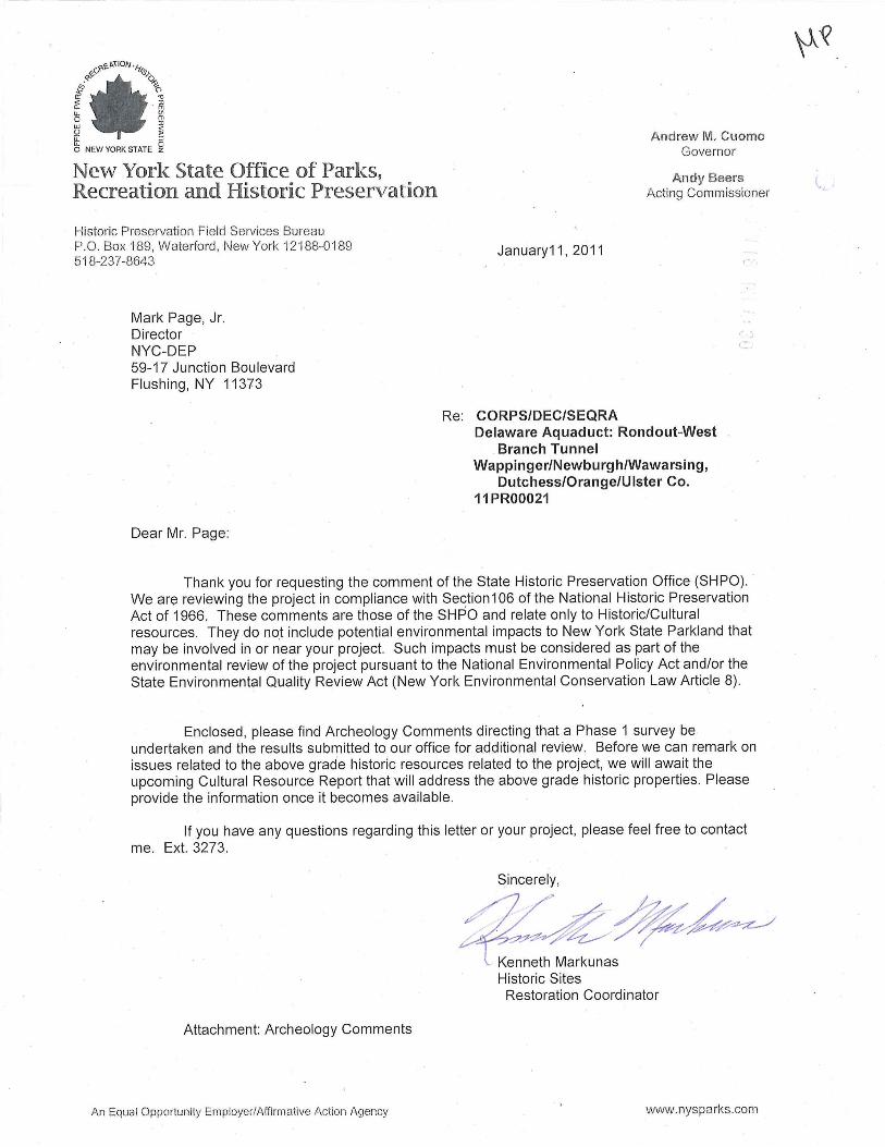

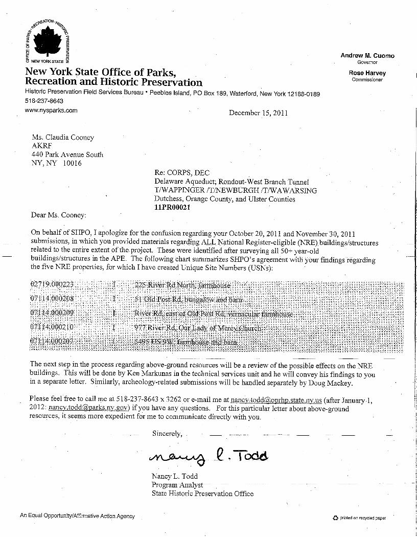
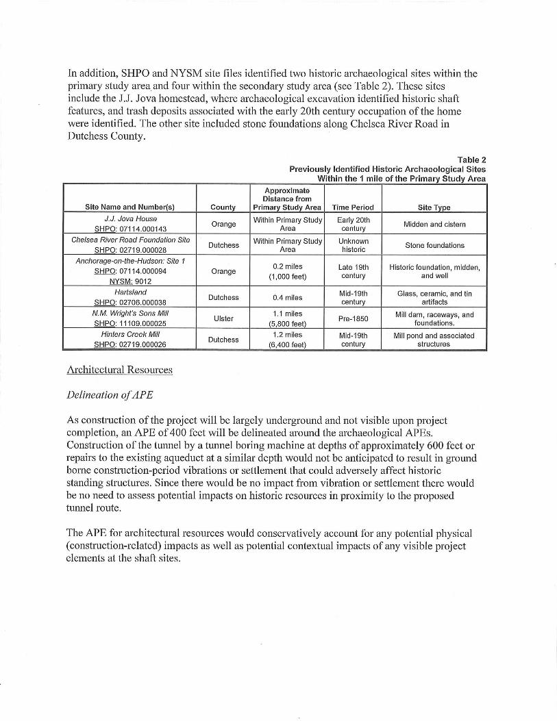
The following letter was issued by SHPO in response to the Phase 1 Archaeological Documentary Study prepared for the portion of the west connection site where grading was proposed in advance of the completion of three deep geotechnical soil borings. SHPO’s comments refer only to that portion of the west connection site and do not address the archaeological sensitivity of the remainder of the west connection site, the east connection site, or the dewatering pipeline route, which are also included within SHPO project review number 11PR00021.
1
Carter H. Strickland, Jr.
Commissioner
Angela Licata Deputy Commissioner [email protected] 59-17 Junction Blvd. Flushing, New York 11373 Tel. (718) 595-4398 Fax (718) 595-4479
October 20, 2011
Mr. Kenneth Markunas Historic Sites Restoration Coordinator New York State Office of Parks, Recreation and Historic Preservation Bureau of Historic Preservation Peebles Island, P.O. Box 189 Waterford, NY 12188-0189 Re: Rondout-West Branch Bypass Tunnel Project Orange and Dutchess
Counties 11PR00021 Dear Mr. Markunas: As you know, the New York City Department of Environmental Protection (DEP) proposes to construct the Rondout-West Branch Bypass Tunnel Project in Orange and Dutchess Counties. As had been described in our methodology for the identification of historic properties provided to you in a letter December 22, 2010, we have delineated Areas of Potential Effect (APEs) for historic resources in Orange and Dutchess Counties and identified historic properties in those APEs. As part of this effort, properties that appear to meet State/National Register (S/NR) eligibility criteria have been identified in the APEs (“potential historic resources”). We have provided herein for each property a historic and architectural narrative, photographs, and a map showing location. We have included information regarding the delineation of the APEs and are seeking your determinations of eligibility for the properties identified in the APEs, presented below. Delineation of Area of Potential Effect for Historic Resources In general, potential effects on historic resources can include both direct physical effects—demolition, alteration, or damage from nearby construction, such as from construction vibration—and indirect effects—the isolation of a property from its surrounding environment or the introduction of visual, audible, or atmospheric (e.g., pollutants) elements that are out of character with a property or that alter its historic setting and context (e.g., contextual effects). Adverse effects can occur if a project would cause a change in the quality of a property that qualifies it for inclusion in the S/NR. Physical, or direct, effects generally have the potential for impacts in a smaller geographic area than contextual or visual effects.
2
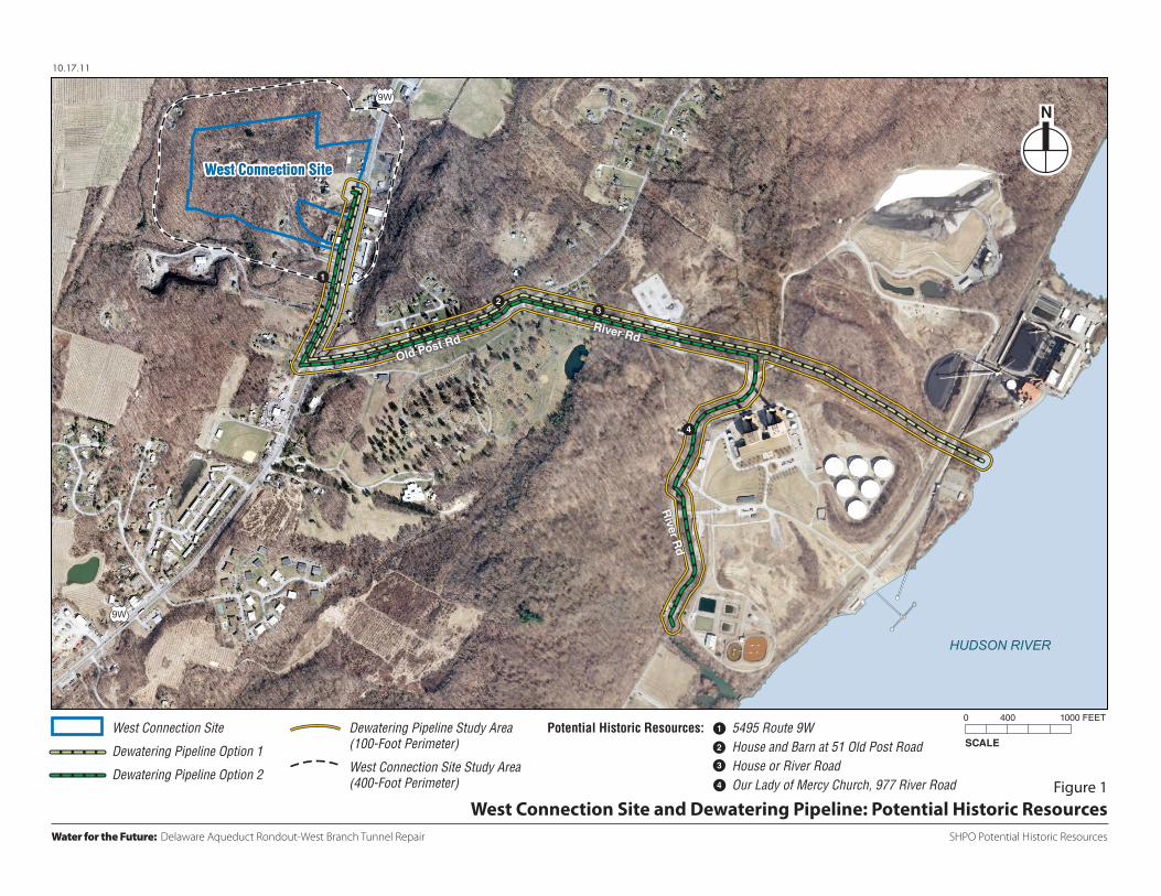
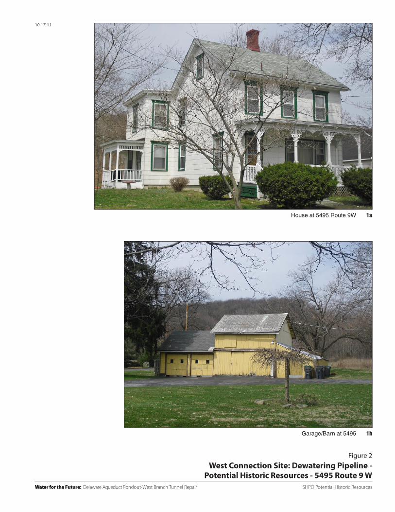
Due to the depth of the proposed bypass tunnel, the proposed tunneling activities for the bypass tunnel would not have the potential to result in construction-related impacts, such as ground-borne vibration, and, therefore, an APE for this project element was not identified. Since construction at the west and east connection sites would require tree removal and grading to allow for project construction and would change the appearance of these sites, the APE for historic resources has been defined as the area within approximately 400 feet of the boundary of the west and east connection sites. Beyond this distance, views would be such that intervening trees, vegetation, and other structures would limit views. The dewatering pipeline would require temporary construction to construct the pipeline underground, and therefore, the APE for the pipeline is limited to potential direct physical effects. As a result, the APE has been defined as those properties fronting the affected construction areas. Within those APEs, an inventory of historic resources was compiled. Figure 1 shows the APE boundaries and historic resources identified within the APE. The definition of the APEs for archaeological and historic resources conforms to the methodology presented in our December 22, 2010, consultation on the project.1 Potential Historic Resources in the APE Orange County West Connection Site No S/NR listed or eligible resources have been identified in the APE for the west connection site. One potential historic resource, a residence and barn at 5495 Route 9W located south of the west connection site, has been identified in the APE. This property consists of a two-story house and a one- to two-story barn/garage (see Figure 1 Resource No. 1 and Figure 2). The house is the northernmost structure on the property and is located approximately 300 feet from the west connection site. The house is set back approximately 50 feet from Route 9W, with the barn at the rear of the property along Pine Road, approximately 125 feet from Route 9W. The gabled house has bracketed eaves, decorative wood window frames, a corbelled central chimney, and front and side porches with decorative millwork. The house possesses high integrity with the exception of what appears to be asbestos cladding, which is assumed to be reversible. South of the house is a two-story wood barn with a one-story garage. The house and barn appear to date to circa 1880, though they do not appear on the 1891 Beers atlas (see Figure 7). The property possesses historic and architectural significance and appears eligible for S/NR listing under Criteria A and C. Dewatering Pipeline No S/NR listed or eligible resources have been identified in the APE for the dewatering pipeline. Four potential historic resources have been identified in the APEs for the dewatering pipeline: Three are relevant regardless of which route is chosen; one additional resource is found along the Option 2 route where it diverges from the Option 1 route (see Figure 1).
1 Letter from Mark Page, DEP to Ruth Pierpont, OPRHP, December 22, 2010.
3
Three potential historic resources have been identified in the APE for Option 1 (see Figure 1). These include the property at 5495 Route 9W, described above, and two additional properties:
• Residential property at 51 Old Post Road. This property consists of a two-story house and a
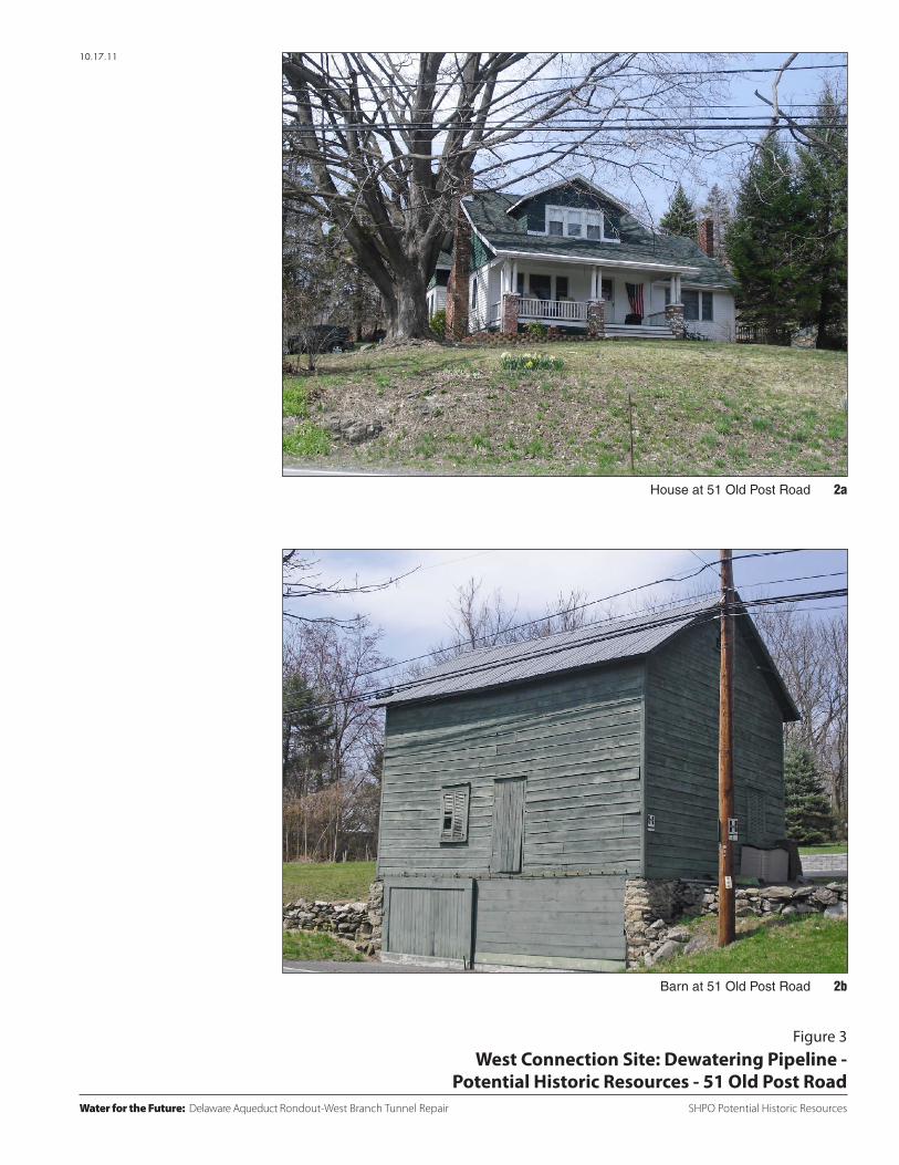
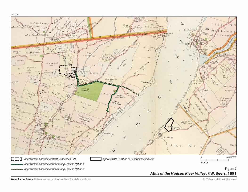
detached barn/garage (see Figure 1 Resource No. 2 and Figure 3). The house is set back approximately 40 feet from Old Post Road on a rise. The house is one and a half stories and clad in clapboard. The house has a large central roof dormer and a front porch with paired columns set on brick piers. It appears that the ground-floor windows facing Old Post Road have been altered, but otherwise the house possesses both historic and architectural integrity. The barn is located along the side of Old Post Road just west of the house. It is set on a stone rubble foundation and clad in wood with a gable roof. The 1891 Beers atlas shows two structures in the approximate location of the house. These structures are located on property owned by D. Allerton and Mrs. Ryan (see Figure 7). Property records on file with Orange County indicate that the house was built in 1925.2 The barn appears to be a late-19th or early 20th century carriage barn or stable built sometime between 1890 and 1920. The property possesses historic and architectural significance and appears eligible for S/NR listing under Criteria A and C.
• Residential property on River Road just west of the Central Hudson Gas & Electric
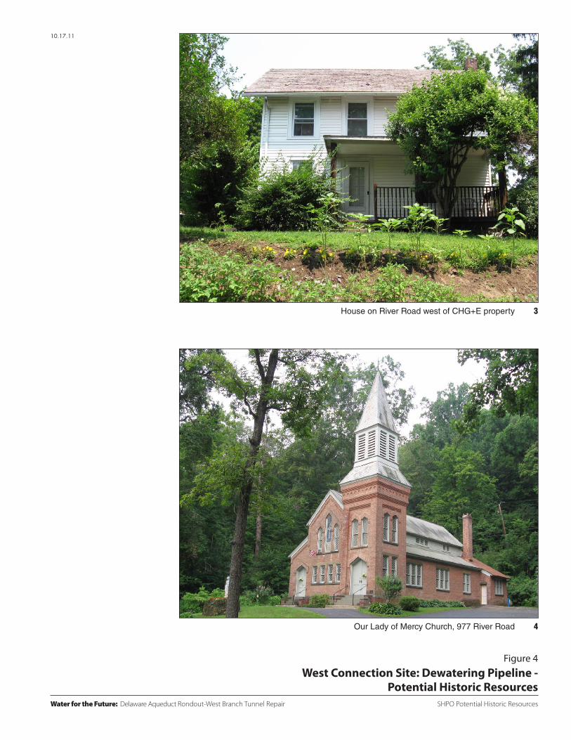
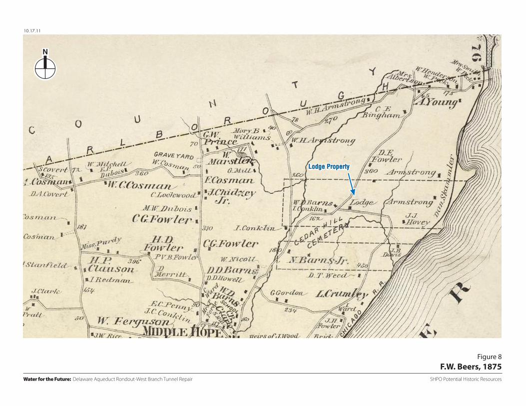
(CHG&E) property. This property consists of a two-story house with a gable roof, set back approximately 20 feet from River Road (see Figure 1 Resource No. 3 and Figure 4). The house appears to date to 1870, although property records on file with Orange County for this tax lot indicate a residence was constructed in 1900.3 However, a structure in this approximate location is depicted on the 1875 Beers atlas as property owned by the Lodge family (see Figure 8). A structure is similarly depicted on the 1891 Beers map, and at this time the structure is situated on a large parcel owned by the Rose Brick Company (see Figure 7). Though the house has been altered with new windows, the porch altered, and a chimney reconstructed or built anew on the north façade, the house retains a mid- to late-19th century character and may possess historical significance if associated with the Rose family and Rose Brick Company (described in greater detail below) under Criterion B.
Four potential historic resources have been identified in the APE for Option 2. These include the three properties described above for Option 1 and one additional potential historic resource located on River Road south of where River Road and Danskammer Road diverge: Our Lady of Mercy Church at 977 River Road. Our Lady of Mercy Church at 977 River Road is set back approximately 75 feet from River Road (see Figure 1 Resource No. 4 and Figure 4). Constructed in 1891, it is the only major building that survives from the company town of Roseton. Roseton was founded by John C. Rose, who built one of the first brickyards in the area in 1884 and gave the town its name. The Rose Brick Company brickyard
2 http://www.wellcomemat.com/video/NY/Newburgh/house-for-sale/FD5132DCDBAPT/ [accessed June 9, 2011] http://www.zillow.com/homedetails/5503-Route-9w-Newburgh-NY-12550/2145157712_zpid/ [accessed June 9, 2011] 3 http://propertydata.orangecounty.gov.com/imate/index.aspx. Tax Lot 8-2-38.2 contains two structures, the subject house along River Road and also a residence fronting on Old Post Road. It is not clear to which structure the 1900 construction date pertains.
4
and town were located along the Hudson River.4 Roseton had housing for its workers, churches, a post office, a commons building, a schoolhouse, and a grocery store. Almost the entire town was demolished when CHG&E purchased the Rose Brick Company land, including its brickyard, to construct power plants. The brickyard is now the site of the Hess Oil Terminal.
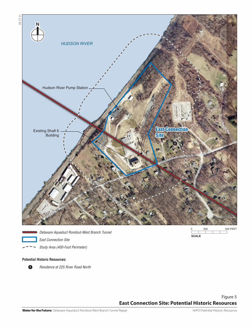
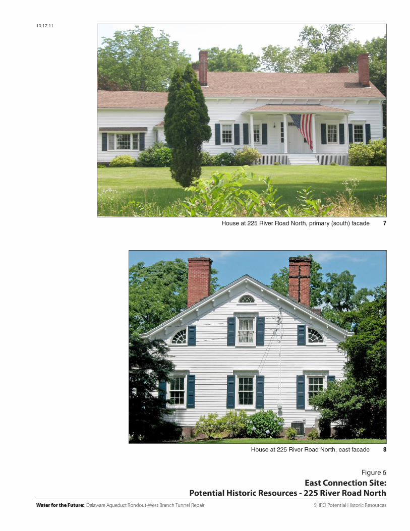
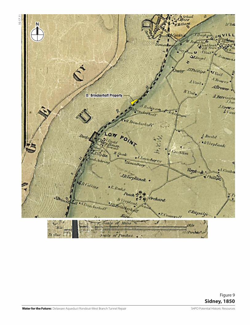
Our Lady of Mercy Church was commissioned by the wife of brick maker Juan Jova. Juan Jova also constructed a large brickyard at about the same time as the Rose family between River Road and the Hudson River (much of this land is now owned and occupied by the Dynegy plant). The chapel was constructed on land owned by the Jovas on the west side of River Road and built of brick manufactured by the Jova brickyard. It has a steeple, pointed arched window openings, stained-glass windows, and high architectural integrity. The church is historically significant and appears eligible for S/NR listing under Criterion A as a remnant of Roseton, a town that was home at the turn of the 20th century to at least a thousand people who made a living at the Rose and Jova brick making companies. It also appears to meet Criterion B for its association with the Jova family and brick manufacturing, one of the major industries along the Hudson River. Bricks manufactured at the Rose and Jova brickyards were used in the construction of such significant structures in New York City as the former Singer Tower, the Empire State Building, the Waldorf Astoria Hotel, the main branch of the New York Public Library on East 42nd Street, and the Customs House at Bowling Green. The church is also architecturally significant and appears to meet Criterion C as an intact example of late-19th century Gothic style architecture. Dutchess County There are no known historic resources in the APE.5 One potential historic resource has been identified within the study area: the residence at 225 River Road, approximately 300 feet north of the east connection site. It is a federal style frame house—the main (east) section appears to date to the early part of the 19th century (see Figure 5 Resource No. 1 and Figure6). The house is oriented at a diagonal to River Road, with the primary façade facing southeast. The house is one and a half stories with a covered front porch. The main entrance is accessed from the porch and contains sidelights and a transom with tracery. The eaves are ornamented with brackets (most likely a later addition), and the windows have decorative wood moldings including hoods. The house appears to have been enlarged with additions to the west. An 1850 map depicts the ownership of the property by D. Brinckerhoff (See Figure 9).6 The Brinckerhoffs are one of Dutchess County’s earliest families and founded Brinckerhoffville along Fishkill Creek. Although the property records on file with Dutchess County lists the construction date as 1800,7 historical records indicate that Derick Brinckerhoff (1786-1877), a former wholesale grocer, purchased 200 acres along the Hudson River in 1820, built a house, and
4 Sources regarding the history of Roseton and our Lady of Mercy Chapel reviewed include Lost Towns of the Hudson Valley, by Wesley and Barbara H. Gottluck, The History Press, 2009 and http://brickcollecting.com/roseton.htm [accessed June 9, 2011]. 5 The Wheeler Hill Historic District, which is listed on the S/NR and is also a protected feature in the Town of Wappinger (Town of Wappinger Comprehensive Plan, adopted September 27, 2010) is at a considerable distance from the east connection site. The historic district’s southern boundary is approximately at Cobblestone Road north of the east connection site. 6 Sidney, 1850. 7 http://geoaccess.co.dutchess.ny.us

River Rd
River R
d
Old Post Rd
HUDSON RIVER
9W
9W
10.17.11
SCALE
0 400 1000 FEET
Water for the Future: Delaware Aqueduct Rondout-West Branch Tunnel Repair SHPO Potential Historic Resources
Figure 1West Connection Site and Dewatering Pipeline: Potential Historic Resources
West Connection SiteWest Connection Site
1
1
2
2
3
3
4
4
West Connection Site
Dewatering Pipeline Option 1
Dewatering Pipeline Option 2
Dewatering Pipeline Study Area(100-Foot Perimeter)
West Connection Site Study Area(400-Foot Perimeter)
5495 Route 9WHouse and Barn at 51 Old Post RoadHouse or River RoadOur Lady of Mercy Church, 977 River Road
Potential Historic Resources:
SHPO Potential Historic ResourcesWater for the Future: Delaware Aqueduct Rondout-West Branch Tunnel Repair
10.17.11
Figure 2West Connection Site: Dewatering Pipeline -
Potential Historic Resources - 5495 Route 9 W
Garage/Barn at 5495
House at 5495 Route 9W
1b
1a
SHPO Potential Historic Resources
Figure 3
10.17.11
Water for the Future: Delaware Aqueduct Rondout-West Branch Tunnel Repair
West Connection Site: Dewatering Pipeline - Potential Historic Resources - 51 Old Post Road
2bBarn at 51 Old Post Road
2aHouse at 51 Old Post Road
SHPO Potential Historic Resources
Figure 4
10.17.11
Water for the Future: Delaware Aqueduct Rondout-West Branch Tunnel Repair
West Connection Site: Dewatering Pipeline - Potential Historic Resources
4Our Lady of Mercy Church, 977 River Road
3House on River Road west of CHG+E property
River Rd N
Sky Top DrLake Dr
Ste
nger
Ct
Natures W
ay
HUDSON RIVER
10.17.11
Figure 5East Connection Site: Potential Historic Resources
SCALE
0 200 500 FEET
East ConnectionSiteEast ConnectionSite
Hudson River Pump Station
Existing Shaft 6Building
1
1
Water for the Future: Delaware Aqueduct Rondout-West Branch Tunnel Repair SHPO Potential Historic Resources
Delaware Aqueduct Rondout-West Branch Tunnel
East Connection Site
Study Area (400-Foot Perimeter)
Residence at 225 River Road North
Potential Historic Resources:
SHPO Potential Historic Resources
10.17.11
Water for the Future: Delaware Aqueduct Rondout-West Branch Tunnel Repair
Figure 6East Connection Site:
Potential Historic Resources - 225 River Road North
8House at 225 River Road North, east facade
7House at 225 River Road North, primary (south) facade
10.17.11
Figure 7Atlas of the Hudson River Valley. F.W. Beers, 1891
SCALE
0 3000 FEET
Water for the Future: Delaware Aqueduct Rondout-West Branch Tunnel Repair SHPO Potential Historic Resources
Approximate Location of West Connection Site
Approximate Location of Dewatering Pipeline Option 2
Approximate Location of Dewatering Pipeline Option 1
Approximate Location of East Connection Site
10.17.11
Figure 8F.W. Beers, 1875
Water for the Future: Delaware Aqueduct Rondout-West Branch Tunnel Repair SHPO Potential Historic Resources
Lodge PropertyLodge Property
10.17.11
Figure 9Sidney, 1850
D. Brinckerhoff PropertyD. Brinckerhoff Property
Water for the Future: Delaware Aqueduct Rondout-West Branch Tunnel Repair SHPO Potential Historic Resources