A GUIDE O UR Wilderness and Ecological Reserves · The Wilderness and Ecological Reserves Act: A...
32
NEWFOUNDLAND AND LABRADOR A GUIDE TO OUR Wilderness and Ecological Reserves
Transcript of A GUIDE O UR Wilderness and Ecological Reserves · The Wilderness and Ecological Reserves Act: A...
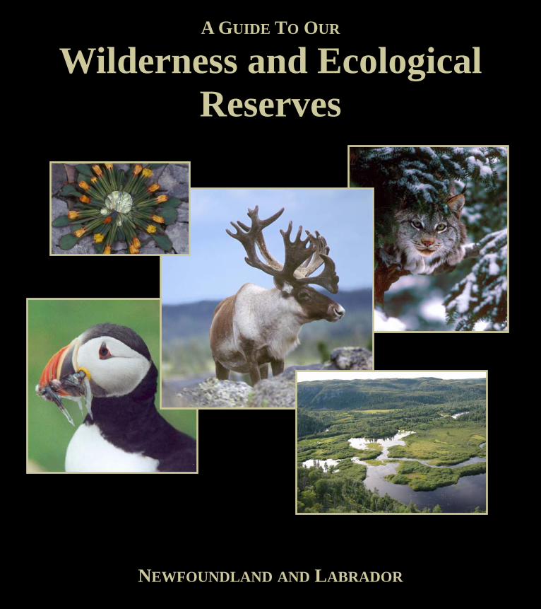
NEWFOUNDLAND AND LABRADOR
A GUIDE TO OUR
Wilderness and Ecological Reserves
2
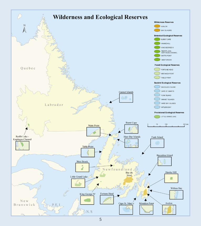
Nature’s Diversity on the Edge of a Continent Wilderness and Ecological Reserves A Path to Responsible Wilderness Conservation The Wilderness and Ecological Reserves Program Wilderness and Ecological Reserves Map Visitor Guidelines Table of Activities and Services Wilderness Reserves Avalon Bay du Nord Ecological Reserves - Botanical Burnt Cape Hawke Hill King George IV Redfir Lake-Kapitagas Channel Watts Point West Brook Ecological Reserves - Fossil Fortune Head Mistaken Point Table Point Ecological Reserves - Seabird Baccalieu Island Cape St. Mary’s Funk Island Gannet Islands Hare Bay Islands Witless Bay Ecological Reserve - Provisional Little Grand Lake Glossary Permit Summary Credits
1 2 3 4 5 6 7
8 9
10 11 12 13 14 15
16 17 18
19 20 21 22 23 24
25 26 28 29
Contents
3
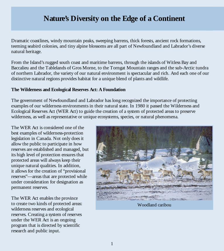
Dramatic coastlines, windy mountain peaks, sweeping barrens, thick forests, ancient rock formations, teeming seabird colonies, and tiny alpine blossoms are all part of Newfoundland and Labrador’s diverse natural heritage. From the Island’s rugged south coast and maritime barrens, through the islands of Witless Bay and Baccalieu and the Tablelands of Gros Morne, to the Torngat Mountain ranges and the sub-Arctic tundra of northern Labrador, the variety of our natural environment is spectacular and rich. And each one of our distinctive natural regions provides habitat for a unique blend of plants and wildlife. The Wilderness and Ecological Reserves Act: A Foundation The government of Newfoundland and Labrador has long recognized the importance of protecting examples of our wilderness environments in their natural state. In 1980 it passed the Wilderness and Ecological Reserves Act (WER Act) to guide the creation of a system of protected areas to preserve wilderness, as well as representative or unique ecosystems, species, or natural phenomena. The WER Act is considered one of the best examples of wilderness-protection legislation in Canada. Not only does it allow the public to participate in how reserves are established and managed, but its high level of protection ensures that protected areas will always keep their unique natural qualities. In addition, it allows for the creation of “provisional reserves”—areas that are protected while under consideration for designation as permanent reserves. The WER Act enables the province to create two kinds of protected areas: wilderness reserves and ecological reserves. Creating a system of reserves under the WER Act is an ongoing program that is directed by scientific research and public input.
1
Woodland caribou
Nature’s Diversity on the Edge of a Continent
4
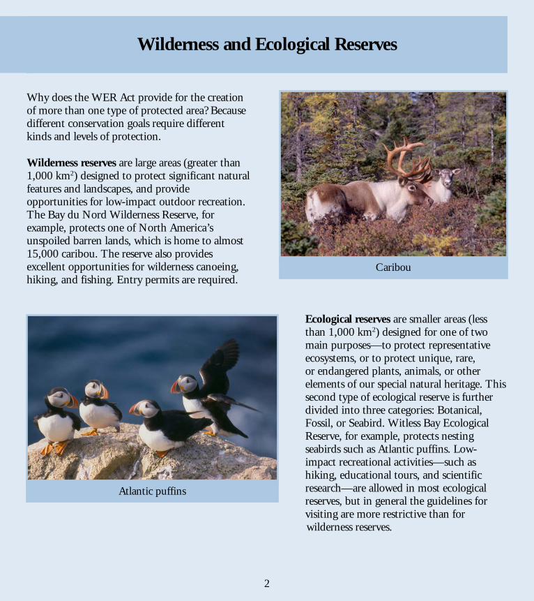
Why does the WER Act provide for the creation of more than one type of protected area? Because different conservation goals require different kinds and levels of protection. Wilderness reserves are large areas (greater than 1,000 km2) designed to protect significant natural features and landscapes, and provide opportunities for low-impact outdoor recreation. The Bay du Nord Wilderness Reserve, for example, protects one of North America’s unspoiled barren lands, which is home to almost 15,000 caribou. The reserve also provides excellent opportunities for wilderness canoeing, hiking, and fishing. Entry permits are required.
Ecological reserves are smaller areas (less than 1,000 km2) designed for one of two main purposes—to protect representative ecosystems, or to protect unique, rare, or endangered plants, animals, or other elements of our special natural heritage. This second type of ecological reserve is further divided into three categories: Botanical, Fossil, or Seabird. Witless Bay Ecological Reserve, for example, protects nesting seabirds such as Atlantic puffins. Low-impact recreational activities—such as hiking, educational tours, and scientific research—are allowed in most ecological reserves, but in general the guidelines for visiting are more restrictive than for
wilderness reserves.
2
Caribou
Atlantic puffins
Wilderness and Ecological Reserves
5
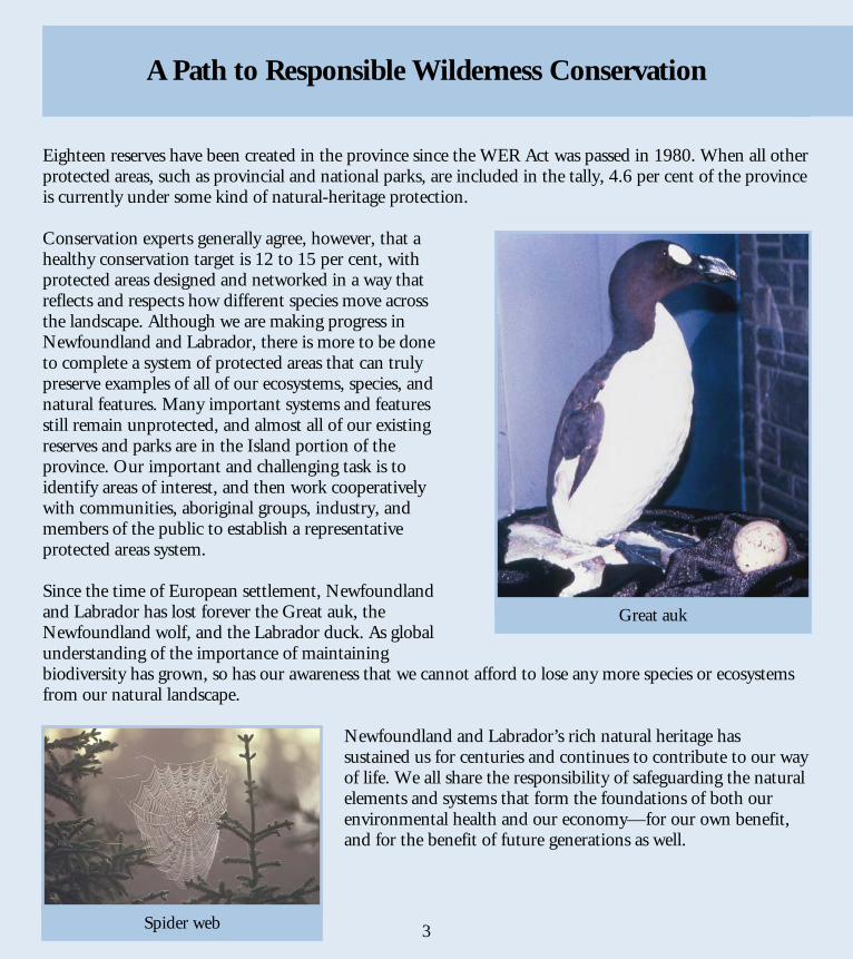
Eighteen reserves have been created in the province since the WER Act was passed in 1980. When all other protected areas, such as provincial and national parks, are included in the tally, 4.6 per cent of the province is currently under some kind of natural-heritage protection. Conservation experts generally agree, however, that a healthy conservation target is 12 to 15 per cent, with protected areas designed and networked in a way that reflects and respects how different species move across the landscape. Although we are making progress in Newfoundland and Labrador, there is more to be done to complete a system of protected areas that can truly preserve examples of all of our ecosystems, species, and natural features. Many important systems and features still remain unprotected, and almost all of our existing reserves and parks are in the Island portion of the province. Our important and challenging task is to identify areas of interest, and then work cooperatively with communities, aboriginal groups, industry, and members of the public to establish a representative protected areas system. Since the time of European settlement, Newfoundland and Labrador has lost forever the Great auk, the Newfoundland wolf, and the Labrador duck. As global understanding of the importance of maintaining biodiversity has grown, so has our awareness that we cannot afford to lose any more species or ecosystems from our natural landscape.
Newfoundland and Labrador’s rich natural heritage has sustained us for centuries and continues to contribute to our way of life. We all share the responsibility of safeguarding the natural elements and systems that form the foundations of both our environmental health and our economy—for our own benefit, and for the benefit of future generations as well.
3
Great auk
Spider web
A Path to Responsible Wilderness Conservation
6
Management Newfoundland and Labrador’s wilderness and ecological reserves are administered by the Parks and Natural Areas Division of the Department of Environment and Conservation. The Division works cooperatively with the Wilderness and Ecological Reserves Advisory Council (WERAC), an independent group of appointed volunteers from across the province who have a wide variety of backgrounds but share an interest in conservation and an awareness of the importance of protected areas. WERAC’s mandate is to advise the provincial government on the establishment of new reserves and the management of existing ones. Vision Statement To protect, in an unimpaired condition, large wilderness areas, representative areas of all provincial ecoregions, and areas that contain rare natural phenomena, in order to preserve the diversity and distinctiveness of the Province’s rich natural heritage and to support an ecologically sustainable future for the benefit of present and future generations.
4
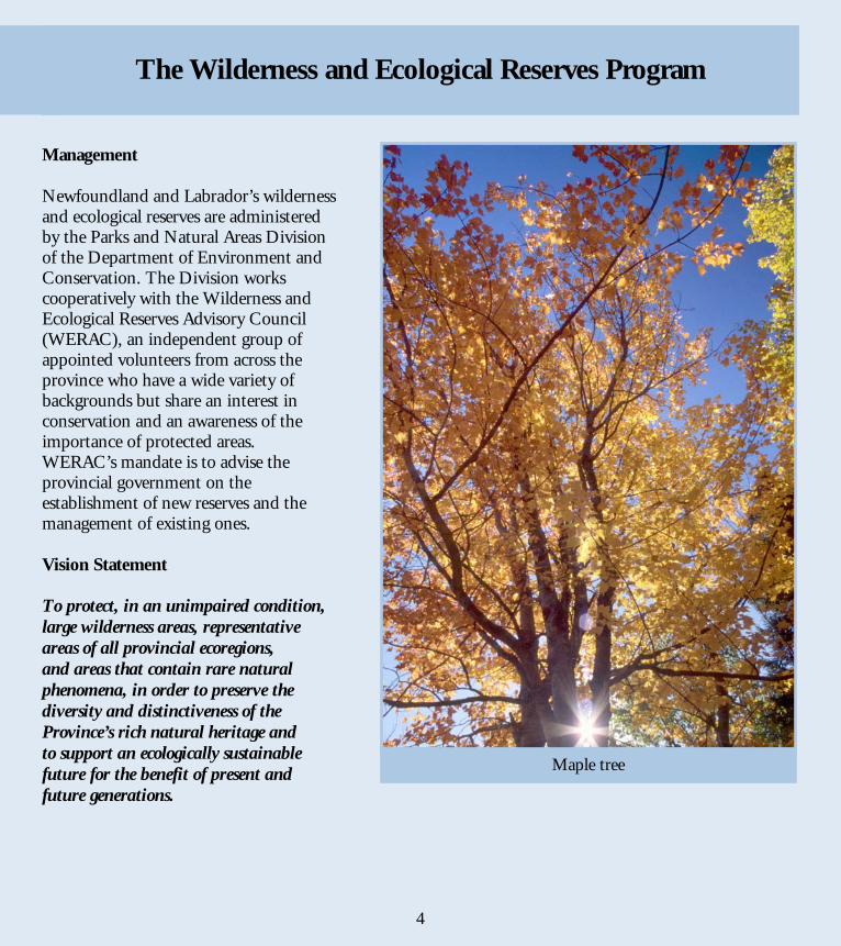
Maple tree
The Wilderness and Ecological Reserves Program
7
5
8
The primary purpose of wilderness and ecological reserves is to protect natural systems and species. Where possible, they also serve the secondary goals of the reserves program: providing venues for research, education, low-impact recreation, and ecotourism. Because conservation is the primary goal, there are rules governing activities within reserves—some are universal, some vary with each reserve. In addition, permits are required for some activities. Generally speaking, the public can visit most ecological reserves for educational purposes or low-impact recreational activities, such as hiking or sightseeing. All wilderness reserves are open to a range of low-impact recreational activities—entry permit required. Groups wishing to tour a reserve for educational or scientific purposes must obtain a permit. Scientists can conduct approved research projects in reserves, provided they obtain a research permit. The following activities are strictly prohibited in all wilderness and ecological reserves:
Facilities and services in most reserves are either limited or non-existent, with four notable exceptions: the Burnt Cape, Cape St. Mary’s, Mistaken Point, and Witless Bay Ecological Reserves. To learn more about each reserve’s facilities, required permits, and accessibility, refer to the profiles in this brochure. For updated details, permit application forms, and more information about visiting a reserve, contact the Parks and Natural Areas Division or check out our website at www.gov.nl.ca/parks.
• disturbing, destroying, or removing plants • introducing plants, animals, or anything else to the reserve landscape • forestry, mining (including exploration), hydro development, agriculture, new roads, tracks, or building construction • all-terrain vehicle (ATV) use
6
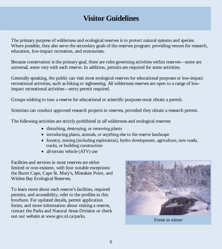
Forest in winter
Visitor Guidelines
9
7
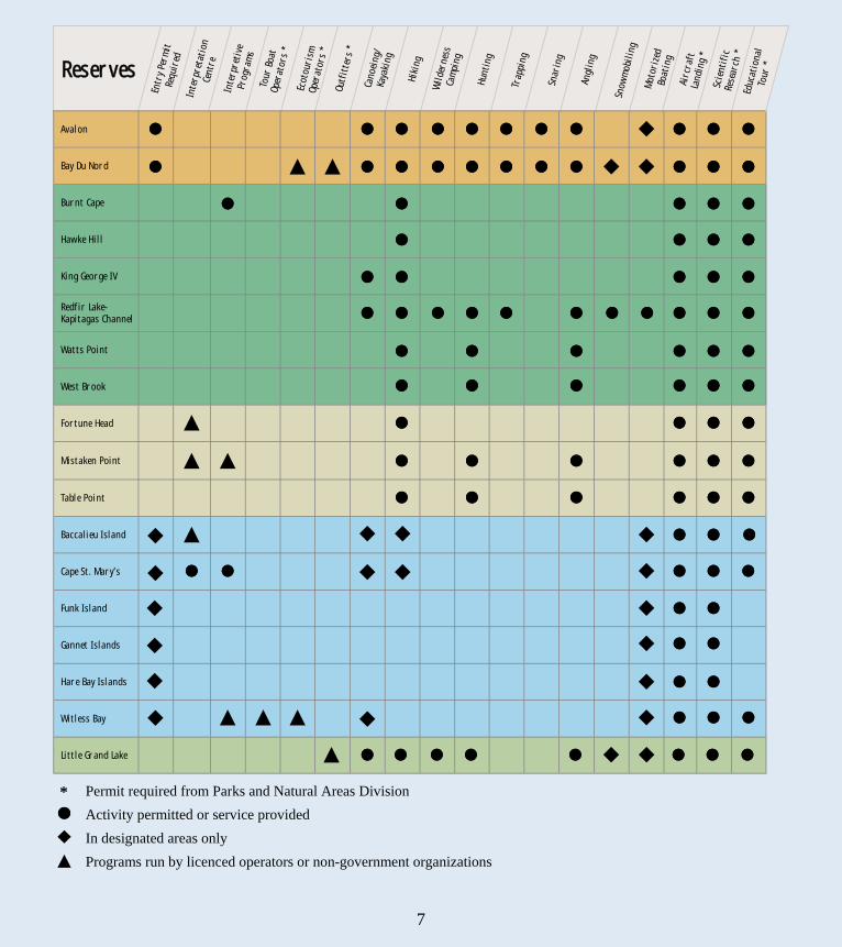
*
Permit required from Parks and Natural Areas Division Activity permitted or service provided In designated areas only Programs run by licenced operators or non-government organizations
Reserves
Entr
y Pe
rmit
Re
quir
ed
Inte
rpre
tati
on
Cent
re
Inte
rpre
tive
Pr
ogra
ms
Tour
Boa
t
Oper
ator
s *
Ecot
ouri
sm
Oper
ator
s *
Outf
itte
rs *
Cano
eing
/
Kaya
king
Hiki
ng
Wil
dern
ess
Ca
mpi
ng
Hunt
ing
Trap
ping
Snar
ing
Angl
ing
Snow
mob
ilin
g M
otor
ized
Bo
atin
g Ai
rcra
ft
Land
ing
* Sc
ient
ific
Rese
arch
*
Avalon
Bay Du Nord
Burnt Cape
Hawke Hill
King George IV
Redfir Lake- Kapitagas Channel
Watts Point
West Brook
Fortune Head
Mistaken Point
Table Point
Baccalieu Island
Cape St. Mary’s
Funk Island
Gannet Islands
Hare Bay Islands
Witless Bay
Little Grand Lake
Ed
ucat
iona
l To
ur *
10
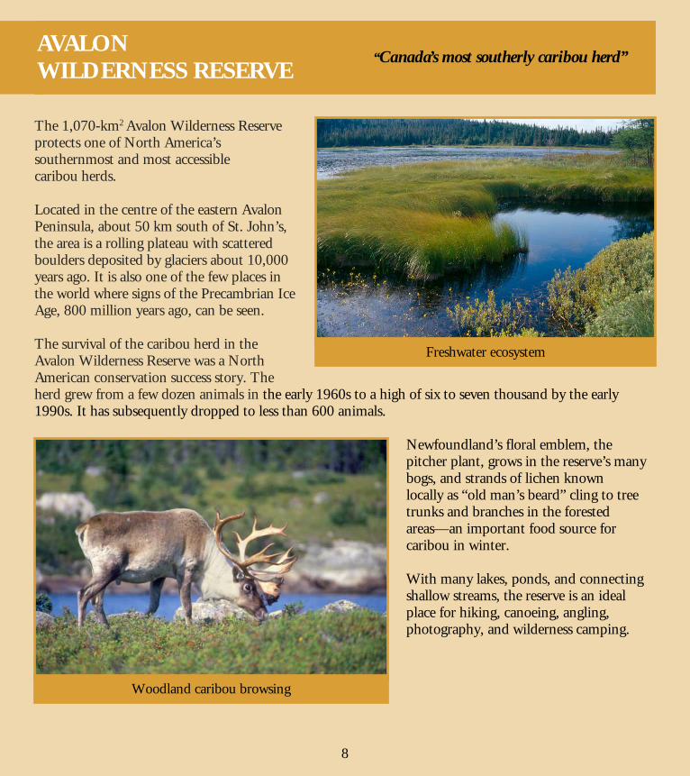
The 1,070-km2 Avalon Wilderness Reserve protects one of North America’s southernmost and most accessible caribou herds. Located in the centre of the eastern Avalon Peninsula, about 50 km south of St. John’s, the area is a rolling plateau with scattered boulders deposited by glaciers about 10,000 years ago. It is also one of the few places in the world where signs of the Precambrian Ice Age, 800 million years ago, can be seen. The survival of the caribou herd in the Avalon Wilderness Reserve was a North American conservation success story. The herd grew from a few dozen animals in the early 1960s to a high of six to seven thousand by the early 1990s. It has subsequently dropped to less than 600 animals.
Newfoundland’s floral emblem, the pitcher plant, grows in the reserve’s many bogs, and strands of lichen known locally as “old man’s beard” cling to tree trunks and branches in the forested areas—an important food source for caribou in winter. With many lakes, ponds, and connecting shallow streams, the reserve is an ideal place for hiking, canoeing, angling, photography, and wilderness camping.
Freshwater ecosystem
Woodland caribou browsing
“Canada’s most southerly caribou herd”
8
AVALON WILDERNESS RESERVE
11
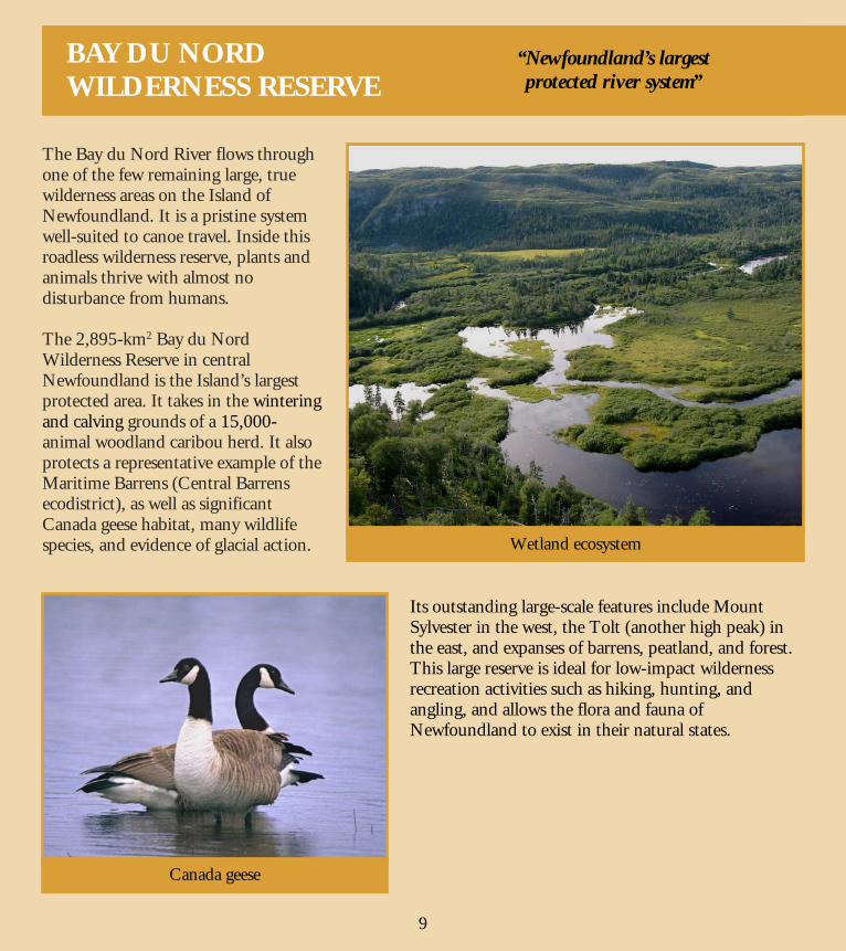
The Bay du Nord River flows through one of the few remaining large, true wilderness areas on the Island of Newfoundland. It is a pristine system well-suited to canoe travel. Inside this roadless wilderness reserve, plants and animals thrive with almost no disturbance from humans. The 2,895-km2 Bay du Nord Wilderness Reserve in central Newfoundland is the Island’s largest protected area. It takes in the wintering and calving grounds of a 15,000-animal woodland caribou herd. It also protects a representative example of the Maritime Barrens (Central Barrens ecodistrict), as well as significant Canada geese habitat, many wildlife species, and evidence of glacial action.
Its outstanding large-scale features include Mount Sylvester in the west, the Tolt (another high peak) in the east, and expanses of barrens, peatland, and forest. This large reserve is ideal for low-impact wilderness recreation activities such as hiking, hunting, and angling, and allows the flora and fauna of Newfoundland to exist in their natural states.
Wetland ecosystem
Canada geese
9
“Newfoundland’s largest protected river system”
BAY DU NORD WILDERNESS RESERVE
12
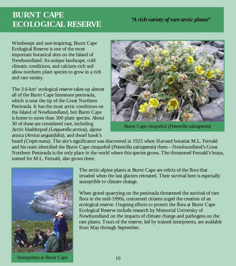
Windswept and awe-inspiring, Burnt Cape Ecological Reserve is one of the most important botanical sites on the Island of Newfoundland. Its unique landscape, cold climatic conditions, and calcium-rich soil allow northern plant species to grow in a rich and rare variety. The 3.6-km2 ecological reserve takes up almost all of the Burnt Cape limestone peninsula, which is near the tip of the Great Northern Peninsula. It has the most arctic conditions on the Island of Newfoundland, but Burnt Cape is home to more than 300 plant species. About 30 of these are considered rare, including Arctic bladderpod (Lesquerella arctica), alpine arnica (Arnica angustifolia), and dwarf hawk’s beard (Crepis nana). The site’s significance was discovered in 1925 when Harvard botanist M.L. Fernald and his team identified the Burnt Cape cinquefoil (Potentilla usticapensis) there—Newfoundland’s Great Northern Peninsula is the only place in the world where this species grows. The threatened Fernald’s braya, named for M.L. Fernald, also grows there.
The arctic-alpine plants at Burnt Cape are relicts of the flora that invaded when the last glaciers retreated. Their survival here is especially susceptible to climate change. When gravel quarrying on the peninsula threatened the survival of rare flora in the mid-1990s, concerned citizens urged the creation of an ecological reserve. Ongoing efforts to protect the flora at Burnt Cape Ecological Reserve include research by Memorial University of Newfoundland on the impacts of climate change and pathogens on the rare plants. Tours of the reserve, led by trained interpreters, are available from May through September.
Burnt Cape cinquefoil (Potentilla usticapensis)
Interpreters at Burnt Cape
“A rich variety of rare arctic plants”
10
BURNT CAPE ECOLOGICAL RESERVE
13
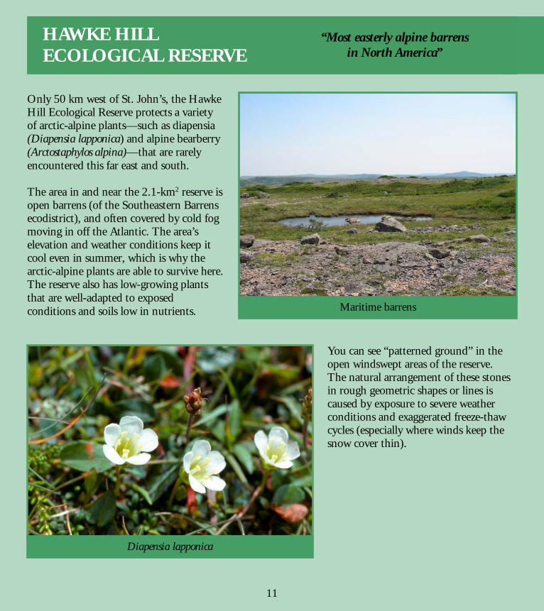
Only 50 km west of St. John’s, the Hawke Hill Ecological Reserve protects a variety of arctic-alpine plants—such as diapensia (Diapensia lapponica) and alpine bearberry (Arctostaphylos alpina)—that are rarely encountered this far east and south. The area in and near the 2.1-km2 reserve is open barrens (of the Southeastern Barrens ecodistrict), and often covered by cold fog moving in off the Atlantic. The area’s elevation and weather conditions keep it cool even in summer, which is why the arctic-alpine plants are able to survive here. The reserve also has low-growing plants that are well-adapted to exposed conditions and soils low in nutrients.
You can see “patterned ground” in the open windswept areas of the reserve. The natural arrangement of these stones in rough geometric shapes or lines is caused by exposure to severe weather conditions and exaggerated freeze-thaw cycles (especially where winds keep the snow cover thin).
Maritime barrens
Diapensia lapponica
“Most easterly alpine barrens in North America”
11
HAWKE HILL ECOLOGICAL RESERVE
14
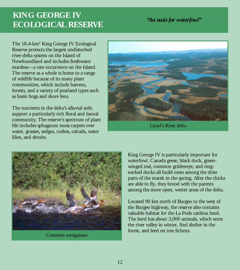
The 18.4-km2 King George IV Ecological Reserve protects the largest undisturbed river-delta system on the Island of Newfoundland and includes freshwater marshes—a rare occurrence on the Island. The reserve as a whole is home to a range of wildlife because of its many plant communities, which include barrens, forests, and a variety of peatland types such as basin bogs and shore fens. The nutrients in the delta’s alluvial soils support a particularly rich floral and faunal community. The reserve’s spectrum of plant life includes sphagnum moss carpets over water, grasses, sedges, rushes, cattails, water lilies, and shrubs.
King George IV is particularly important for waterfowl. Canada geese, black duck, green-winged teal, common goldeneye, and ring-necked ducks all build nests among the drier parts of the marsh in the spring. After the chicks are able to fly, they brood with the parents among the more open, wetter areas of the delta. Located 90 km north of Burgeo to the west of the Burgeo highway, the reserve also contains valuable habitat for the La Poile caribou herd. The herd has about 3,000 animals, which enter the river valley in winter, find shelter in the forest, and feed on tree lichens.
Lloyd’s River delta
Common mergansers
“An oasis for waterfowl”
12
KING GEORGE IV ECOLOGICAL RESERVE
15
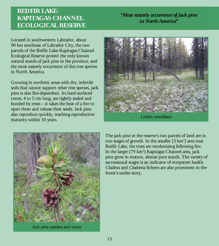
Located in southwestern Labrador, about 90 km southeast of Labrador City, the two parcels of the Redfir Lake-Kapitagas Channel Ecological Reserve protect the only known natural stands of jack pine in the province, and the most easterly occurrence of this tree species in North America. Growing in northern areas with dry, infertile soils that cannot support other tree species, jack pine is also fire-dependent. Its hard-surfaced cones, 4 to 5 cm long, are tightly sealed and bonded by resin—it takes the heat of a fire to open them and release their seeds. Jack pine also reproduce quickly, reaching reproductive maturity within 10 years.
The jack pine in the reserve’s two parcels of land are in two stages of growth. In the smaller (3 km2) area near Redfir Lake, the trees are recolonizing following fire. In the larger (79 km2) Kapitagas Channel area, jack pine grow in mature, almost pure stands. The variety of successional stages is an indicator of ecosystem health. Cladina and Cladonia lichens are also prominent in the forest’s under-story.
Jack pine needles and cones
Lichen woodland
“Most easterly occurrence of jack pine in North America”
13
REDFIR LAKE- KAPITAGAS CHANNEL ECOLOGICAL RESERVE
16
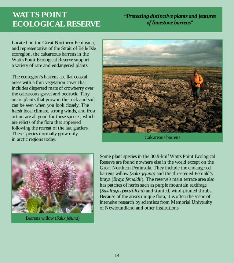
Located on the Great Northern Peninsula, and representative of the Strait of Belle Isle ecoregion, the calcareous barrens in the Watts Point Ecological Reserve support a variety of rare and endangered plants. The ecoregion’s barrens are flat coastal areas with a thin vegetation cover that includes dispersed mats of crowberry over the calcareous gravel and bedrock. Tiny arctic plants that grow in the rock and soil can be seen when you look closely. The harsh local climate, strong winds, and frost action are all good for these species, which are relicts of the flora that appeared following the retreat of the last glaciers. These species normally grow only in arctic regions today.
Some plant species in the 30.9-km2 Watts Point Ecological Reserve are found nowhere else in the world except on the Great Northern Peninsula. They include the endangered barrens willow (Salix jejuna) and the threatened Fernald’s braya (Braya fernaldii). The reserve’s main terrace area also has patches of herbs such as purple mountain saxifrage (Saxifraga oppositifolia) and stunted, wind-pruned shrubs. Because of the area’s unique flora, it is often the scene of intensive research by scientists from Memorial University of Newfoundland and other institutions.
Calcareous barrens
Barrens willow (Salix jejuna)
“Protecting distinctive plants and features of limestone barrens”
14
WATTS POINT ECOLOGICAL RESERVE
17
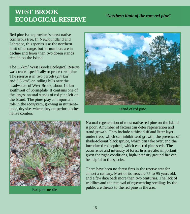
Red pine is the province’s rarest native coniferous tree. In Newfoundland and Labrador, this species is at the northern limit of its range, but its numbers are in decline and fewer than two dozen stands remain on the Island. The 11-km2 West Brook Ecological Reserve was created specifically to protect red pine. The reserve is in two parcels (2.4 km2 and 8.3 km2) on rolling hills near the headwaters of West Brook, about 14 km southwest of Springdale. It contains one of the largest natural stands of red pine left on the Island. The pines play an important role in the ecosystem, growing in nutrient– poor, dry sites where they outperform other native conifers.
Natural regeneration of most native red pine on the Island is poor. A number of factors can deter regeneration and stand growth. They include a thick duff and litter layer under trees, which can inhibit seed growth; the presence of shade-tolerant black spruce, which can take over; and the introduced red squirrel, which eats red pine seeds. The occurrence and intensity of forest fires are also important; given the right conditions, high-intensity ground fire can be helpful to the species. There have been no forest fires in the reserve area for almost a century. Most of its trees are 75 to 95 years old, and a few date back more than two centuries. The lack of wildfires and the removal of regenerating seedlings by the public are threats to the red pine in the area.
Stand of red pine
Red pine needles
“Northern limit of the rare red pine”
15
WEST BROOK ECOLOGICAL RESERVE
18
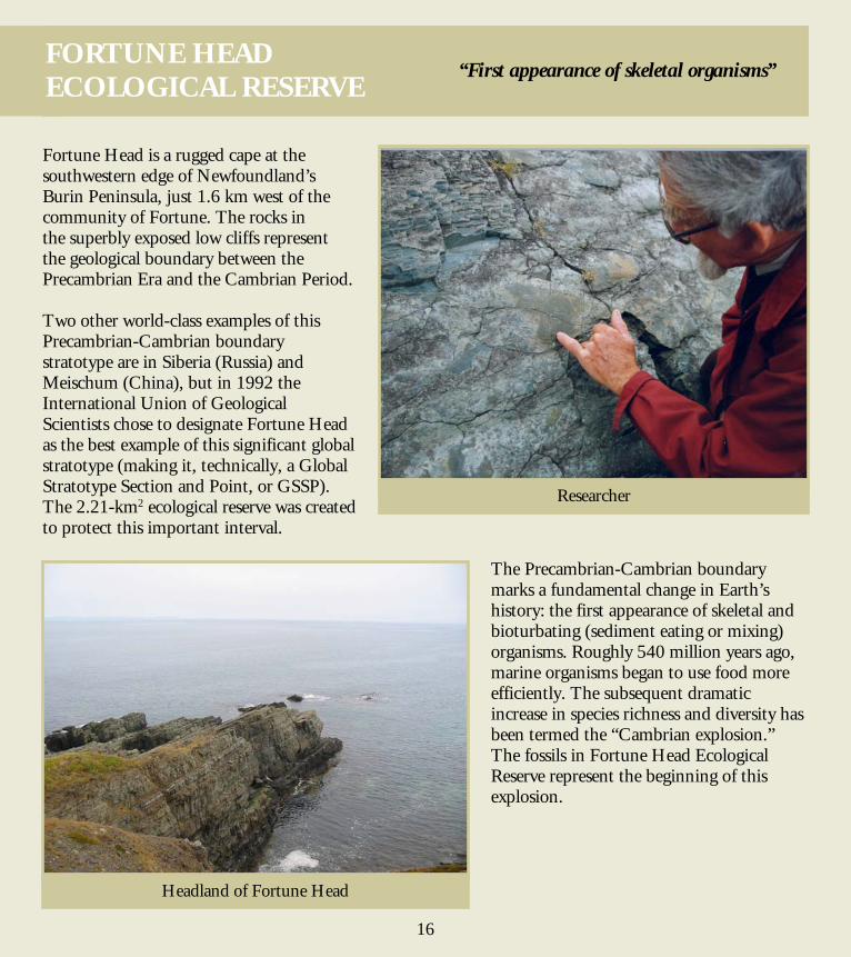
Fortune Head is a rugged cape at the southwestern edge of Newfoundland’s Burin Peninsula, just 1.6 km west of the community of Fortune. The rocks in the superbly exposed low cliffs represent the geological boundary between the Precambrian Era and the Cambrian Period. Two other world-class examples of this Precambrian-Cambrian boundary stratotype are in Siberia (Russia) and Meischum (China), but in 1992 the International Union of Geological Scientists chose to designate Fortune Head as the best example of this significant global stratotype (making it, technically, a Global Stratotype Section and Point, or GSSP). The 2.21-km2 ecological reserve was created to protect this important interval.
The Precambrian-Cambrian boundary marks a fundamental change in Earth’s history: the first appearance of skeletal and bioturbating (sediment eating or mixing) organisms. Roughly 540 million years ago, marine organisms began to use food more efficiently. The subsequent dramatic increase in species richness and diversity has been termed the “Cambrian explosion.” The fossils in Fortune Head Ecological Reserve represent the beginning of this explosion.
Researcher
Headland of Fortune Head
“First appearance of skeletal organisms”
16
FORTUNE HEAD ECOLOGICAL RESERVE
19
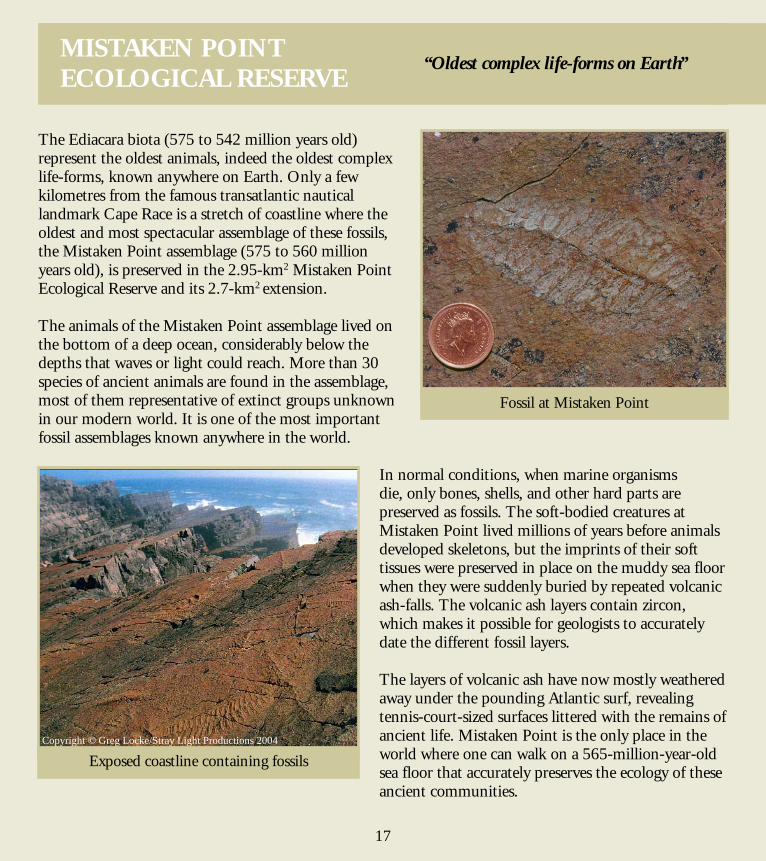
The Ediacara biota (575 to 542 million years old) represent the oldest animals, indeed the oldest complex life-forms, known anywhere on Earth. Only a few kilometres from the famous transatlantic nautical landmark Cape Race is a stretch of coastline where the oldest and most spectacular assemblage of these fossils, the Mistaken Point assemblage (575 to 560 million years old), is preserved in the 2.95-km2 Mistaken Point Ecological Reserve and its 2.7-km2 extension. The animals of the Mistaken Point assemblage lived on the bottom of a deep ocean, considerably below the depths that waves or light could reach. More than 30 species of ancient animals are found in the assemblage, most of them representative of extinct groups unknown in our modern world. It is one of the most important fossil assemblages known anywhere in the world.
In normal conditions, when marine organisms die, only bones, shells, and other hard parts are preserved as fossils. The soft-bodied creatures at Mistaken Point lived millions of years before animals developed skeletons, but the imprints of their soft tissues were preserved in place on the muddy sea floor when they were suddenly buried by repeated volcanic ash-falls. The volcanic ash layers contain zircon, which makes it possible for geologists to accurately date the different fossil layers. The layers of volcanic ash have now mostly weathered away under the pounding Atlantic surf, revealing tennis-court-sized surfaces littered with the remains of ancient life. Mistaken Point is the only place in the world where one can walk on a 565-million-year-old sea floor that accurately preserves the ecology of these ancient communities.
Fossil at Mistaken Point
“Oldest complex life-forms on Earth”
17
Exposed coastline containing fossils Copyright © Greg Locke/Stray Light Productions 2004
MISTAKEN POINT ECOLOGICAL RESERVE
20
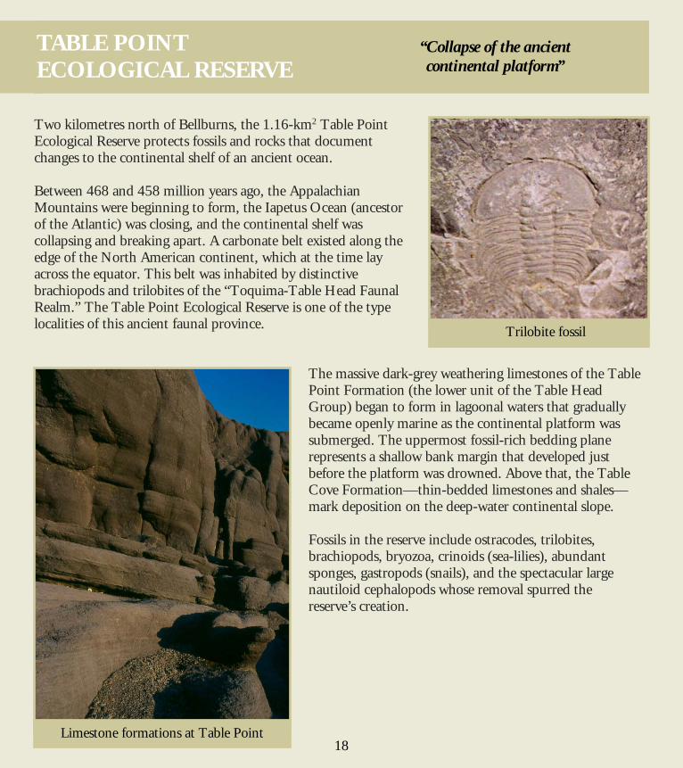
Two kilometres north of Bellburns, the 1.16-km2 Table Point Ecological Reserve protects fossils and rocks that document changes to the continental shelf of an ancient ocean. Between 468 and 458 million years ago, the Appalachian Mountains were beginning to form, the Iapetus Ocean (ancestor of the Atlantic) was closing, and the continental shelf was collapsing and breaking apart. A carbonate belt existed along the edge of the North American continent, which at the time lay across the equator. This belt was inhabited by distinctive brachiopods and trilobites of the “Toquima-Table Head Faunal Realm.” The Table Point Ecological Reserve is one of the type localities of this ancient faunal province.
The massive dark-grey weathering limestones of the Table Point Formation (the lower unit of the Table Head Group) began to form in lagoonal waters that gradually became openly marine as the continental platform was submerged. The uppermost fossil-rich bedding plane represents a shallow bank margin that developed just before the platform was drowned. Above that, the Table Cove Formation—thin-bedded limestones and shales—mark deposition on the deep-water continental slope. Fossils in the reserve include ostracodes, trilobites, brachiopods, bryozoa, crinoids (sea-lilies), abundant sponges, gastropods (snails), and the spectacular large nautiloid cephalopods whose removal spurred the reserve’s creation.
Limestone formations at Table Point
Trilobite fossil
“Collapse of the ancient continental platform”
18
TABLE POINT ECOLOGICAL RESERVE
21
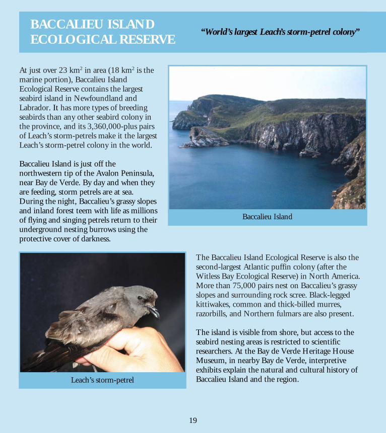
At just over 23 km2 in area (18 km2 is the marine portion), Baccalieu Island Ecological Reserve contains the largest seabird island in Newfoundland and Labrador. It has more types of breeding seabirds than any other seabird colony in the province, and its 3,360,000-plus pairs of Leach’s storm-petrels make it the largest Leach’s storm-petrel colony in the world. Baccalieu Island is just off the northwestern tip of the Avalon Peninsula, near Bay de Verde. By day and when they are feeding, storm petrels are at sea. During the night, Baccalieu’s grassy slopes and inland forest teem with life as millions of flying and singing petrels return to their underground nesting burrows using the protective cover of darkness.
The Baccalieu Island Ecological Reserve is also the second-largest Atlantic puffin colony (after the Witless Bay Ecological Reserve) in North America. More than 75,000 pairs nest on Baccalieu’s grassy slopes and surrounding rock scree. Black-legged kittiwakes, common and thick-billed murres, razorbills, and Northern fulmars are also present. The island is visible from shore, but access to the seabird nesting areas is restricted to scientific researchers. At the Bay de Verde Heritage House Museum, in nearby Bay de Verde, interpretive exhibits explain the natural and cultural history of Baccalieu Island and the region.
Baccalieu Island
Leach’s storm-petrel
“World’s largest Leach’s storm-petrel colony”
19
BACCALIEU ISLAND ECOLOGICAL RESERVE

22
Cape St. Mary’s Ecological Reserve is one of the best and most accessible places in the world to see nesting seabirds. Inside the bright interpretive centre displays and programs explain the life cycles of seabirds and the nature of the marine and terrestrial environment. A hike across open meadows—with a broad view over the ocean—brings you at cliff-top level to within 10 metres of the thousands of Northern gannets that nest each summer on the spectacular sea stack known as Bird Rock. Located about 200 km southwest of St. John’s, the Cape is one of the province’s major seabird colonies. At 64 km2 (54 km2 of which is a marine portion), the reserve is home to 24,000 Northern gannets, 20,000 black-legged kittiwakes, 20,000 common murres, and 2,000 thick-billed murres. In addition, more than 100 pairs of razorbills, more than 60 pairs of black guillemots, plus double-crested and great cormorants, and Northern fulmars nest there. The season to view the nesting birds is May through September.
Cape St. Mary’s lies within the Eastern Hyper-oceanic Barrens ecoregion, with its distinctive arctic-tundra vegetation, treeless vistas, wildflowers, tough grasses, and variety of wildlife. The waters offshore are an important wintering site for thousands of seaducks, including harlequins, common eiders, scoters, and long-tailed ducks.
Northern gannets
Bird Rock
“Most southerly accessible Northern gannet colony in the world”
20
CAPE ST. MARY’S ECOLOGICAL RESERVE
23
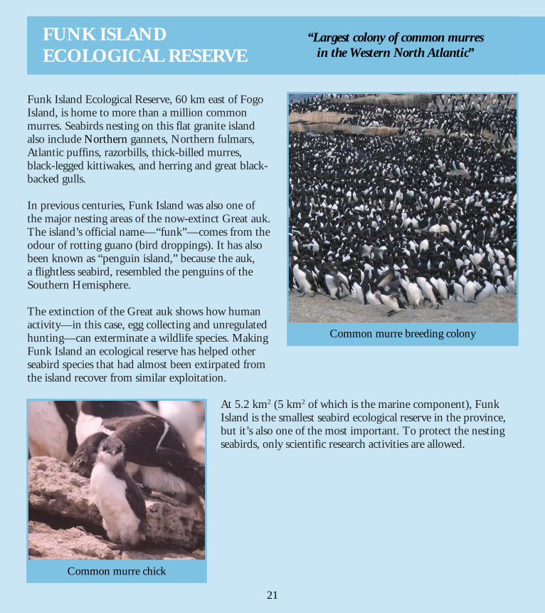
Funk Island Ecological Reserve, 60 km east of Fogo Island, is home to more than a million common murres. Seabirds nesting on this flat granite island also include Northern gannets, Northern fulmars, Atlantic puffins, razorbills, thick-billed murres, black-legged kittiwakes, and herring and great black-backed gulls. In previous centuries, Funk Island was also one of the major nesting areas of the now-extinct Great auk. The island’s official name—“funk”—comes from the odour of rotting guano (bird droppings). It has also been known as “penguin island,” because the auk, a flightless seabird, resembled the penguins of the Southern Hemisphere. The extinction of the Great auk shows how human activity—in this case, egg collecting and unregulated hunting—can exterminate a wildlife species. Making Funk Island an ecological reserve has helped other seabird species that had almost been extirpated from the island recover from similar exploitation.
At 5.2 km2 (5 km2 of which is the marine component), Funk Island is the smallest seabird ecological reserve in the province, but it’s also one of the most important. To protect the nesting seabirds, only scientific research activities are allowed.
Common murre breeding colony
Common murre chick
“Largest colony of common murres in the Western North Atlantic”
21
FUNK ISLAND ECOLOGICAL RESERVE
24
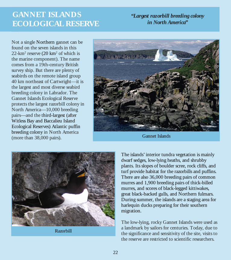
Not a single Northern gannet can be found on the seven islands in this 22-km2 reserve (20 km2 of which is the marine component). The name comes from a 19th-century British survey ship. But there are plenty of seabirds on the remote island group 40 km northeast of Cartwright—it is the largest and most diverse seabird breeding colony in Labrador. The Gannet Islands Ecological Reserve protects the largest razorbill colony in North America—10,000 breeding pairs—and the third-largest (after Witless Bay and Baccalieu Island Ecological Reserves) Atlantic puffin breeding colony in North America (more than 38,000 pairs).
The islands’ interior tundra vegetation is mainly dwarf sedges, low-lying heaths, and shrubby plants. Its slopes of boulder scree, rock cliffs, and turf provide habitat for the razorbills and puffins. There are also 36,000 breeding pairs of common murres and 1,900 breeding pairs of thick-billed murres, and scores of black-legged kittiwakes, great black-backed gulls, and Northern fulmars. During summer, the islands are a staging area for harlequin ducks preparing for their southern migration. The low-lying, rocky Gannet Islands were used as a landmark by sailors for centuries. Today, due to the significance and sensitivity of the site, visits to the reserve are restricted to scientific researchers.
Gannet Islands
Razorbill
“Largest razorbill breeding colony in North America”
22
GANNET ISLANDS ECOLOGICAL RESERVE
25
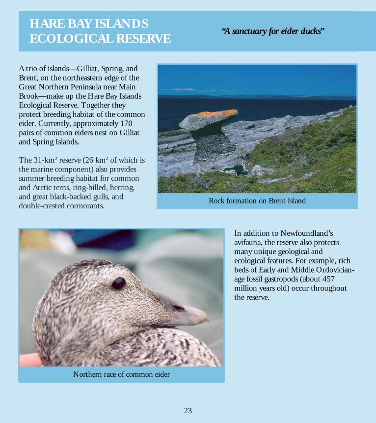
A trio of islands—Gilliat, Spring, and Brent, on the northeastern edge of the Great Northern Peninsula near Main Brook—make up the Hare Bay Islands Ecological Reserve. Together they protect breeding habitat of the common eider. Currently, approximately 170 pairs of common eiders nest on Gilliat and Spring Islands. The 31-km2 reserve (26 km2 of which is the marine component) also provides summer breeding habitat for common and Arctic terns, ring-billed, herring, and great black-backed gulls, and double-crested cormorants.
In addition to Newfoundland’s avifauna, the reserve also protects many unique geological and ecological features. For example, rich beds of Early and Middle Ordovician-age fossil gastropods (about 457 million years old) occur throughout the reserve.
Rock formation on Brent Island
Northern race of common eider
“A sanctuary for eider ducks”
23
HARE BAY ISLANDS ECOLOGICAL RESERVE
26
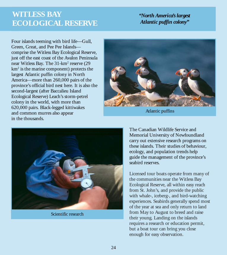
Four islands teeming with bird life—Gull, Green, Great, and Pee Pee Islands—comprise the Witless Bay Ecological Reserve, just off the east coast of the Avalon Peninsula near Witless Bay. The 31-km2 reserve (29 km2 is the marine component) protects the largest Atlantic puffin colony in North America—more than 260,000 pairs of the province’s official bird nest here. It is also the second-largest (after Baccalieu Island Ecological Reserve) Leach’s storm-petrel colony in the world, with more than 620,000 pairs. Black-legged kittiwakes and common murres also appear in the thousands.
The Canadian Wildlife Service and Memorial University of Newfoundland carry out extensive research programs on these islands. Their studies of behaviour, ecology, and population trends help guide the management of the province’s seabird reserves. Licensed tour boats operate from many of the communities near the Witless Bay Ecological Reserve, all within easy reach from St. John’s, and provide the public with whale-, iceberg-, and bird-watching experiences. Seabirds generally spend most of the year at sea and only return to land from May to August to breed and raise their young. Landing on the islands requires a research or education permit, but a boat tour can bring you close enough for easy observation.
Atlantic puffins
Scientific research
“North America’s largest Atlantic puffin colony”
24
WITLESS BAY ECOLOGICAL RESERVE
27
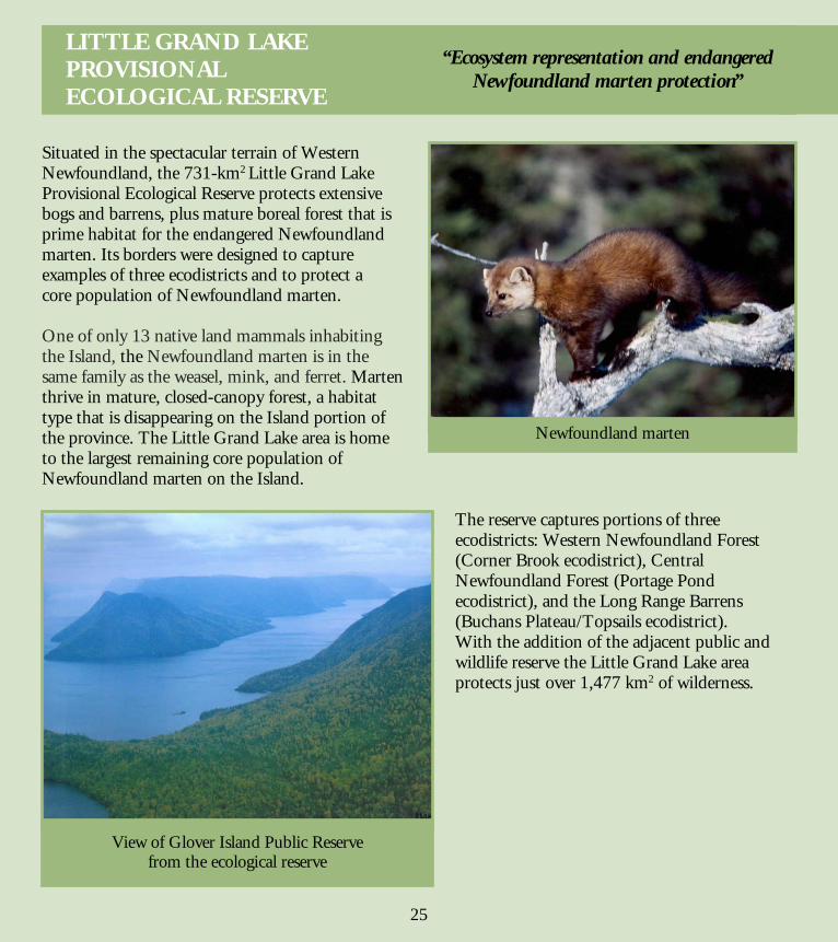
Situated in the spectacular terrain of Western Newfoundland, the 731-km2 Little Grand Lake Provisional Ecological Reserve protects extensive bogs and barrens, plus mature boreal forest that is prime habitat for the endangered Newfoundland marten. Its borders were designed to capture examples of three ecodistricts and to protect a core population of Newfoundland marten. One of only 13 native land mammals inhabiting the Island, the Newfoundland marten is in the same family as the weasel, mink, and ferret. Marten thrive in mature, closed-canopy forest, a habitat type that is disappearing on the Island portion of the province. The Little Grand Lake area is home to the largest remaining core population of Newfoundland marten on the Island.
The reserve captures portions of three ecodistricts: Western Newfoundland Forest (Corner Brook ecodistrict), Central Newfoundland Forest (Portage Pond ecodistrict), and the Long Range Barrens (Buchans Plateau/Topsails ecodistrict). With the addition of the adjacent public and wildlife reserve the Little Grand Lake area protects just over 1,477 km2 of wilderness.
Newfoundland marten
View of Glover Island Public Reserve from the ecological reserve
“Ecosystem representation and endangered Newfoundland marten protection”
25
LITTLE GRAND LAKE PROVISIONAL ECOLOGICAL RESERVE
28
arctic-alpine A descriptive term for plants that are usually restricted to arctic or alpine habitats and that cannot grow where temperatures are too warm, either winter or summer. These plants are at their southern limit of distribution on the island of Newfoundland. barrens A primarily treeless area containing low-growing plants that are well-adapted to exposed conditions and soils low in nutrients. Also called heath or heathland, because much of the plant life found on them belongs to the heath family. calcareous Rock consisting of or containing calcium. core population The total number of individuals of a given species or other class of organisms that inhabit a central location. dwarf shrub A shrub that is shorter or slower growing than normal forms. ecodistrict In the pyramid system of ecological land classification, ecodistricts (or subregions) are the stratum below ecoregions. Smaller in scale than ecoregions, they are identified by their geology and geomorphology (the way surface landscape features were formed). These factors, plus the variety and character of landscape relief, distinguish one ecodistrict from another. ecoregion An area that has distinctive, recurring patterns of vegetation and soil development that are determined and controlled by geology and regional climate. Ecoregions (or natural regions) can be distinguished from each other by plant communities, landscapes, geology, and other features. ecosystem The interacting complex of a natural community—plants, animals, and micro-organisms—and their environment, which function as an ecological unit. era A major division of geological time, usually subdivided into two or more periods.
26
Glossary
29
habitat The place in which an organism lives, which is characterized by its physical features or dominant plant types. Freshwater habitats, for example, include streams, ponds, rivers, and lakes. limestone Rock consisting mainly of calcium carbonate, often composed of the organic remains of sea animals such as molluscs and coral. In some places in the province, its high pH levels support specialized flora, such as braya. patterned ground Surface stones arranged in circles, polygons, or long stripes caused by intense freeze/thaw cycles in cold, sparsely vegetated areas. Also called frost polygons. period A unit of geological time during which a system of rocks formed. protected area An area of land and/or sea especially dedicated to the protection and maintenance of biological diversity and of natural and associated cultural resources, that is managed through legal or other effective means. scree Fragmented rocks, broken by frost action, that roll down slopes and accumulate at the base of cliffs. sea stack An isolated pillar of rock separated from a headland by erosion. stratotype All geological formations are named after the geographic location or the prominent named geographic feature of their type sections. A stratotype is a geographic location where exposed rock provided the basis for the originally published name and description of a rock formation. Type sections usually include both the upper and lower boundaries of the formation (by convention, the upper boundary is taken to be the bottom of the lower boundary of the next formation). type locality The specific geographic locality where the stratotype of a layered stratigraphic unit is situated. wilderness An uncultivated, unsettled region left in its natural condition, especially a large wild tract of land covered with dense vegetation or forests, often uninhabited by humans.
27
Glossary
30
The following permits are required in Wilderness and Ecological Reserves so that Parks and Natural Areas Division can monitor reserve usage. All permits are available free of charge. Entry Permit-Wilderness Reserve Every visitor to a wilderness reserve requires an entry permit. Application forms for these permits are available at a variety of locations around the province and are usually processed within one day. Entry Permit-Ecological Reserve Entry permits are not required for access to most ecological reserves. The exception is seabird ecological reserves. Entry permits are not required for access to the marine portion of these reserves but they are required for access to sensitive nesting areas. Scientific Research Anyone who wants to conduct scientific research in a wilderness or ecological reserve requires a scientific research permit. Commercial Operator All commercial operators, including outfitters and tour guides, whose activities take them inside a reserve’s borders require a commercial operator permit. Educational Tour Any group, including school, university, or conference groups, conducting a tour within a wilderness or ecological reserve requires an educational tour permit. Seabird Ecological Reserve Special Access Anyone wishing to land on Gull Island (Witless Bay Ecological Reserve) or Baccalieu Island Ecological Reserve and access nesting colonies for filming or photography requires a special access permit. The number of permits issued each year is limited and available on a first-come, first-served basis. Application forms for scientific research, commercial operator, educational tour, and seabird ecological reserve special access permits are available online at www.gov.nl.ca/parks. Completed forms should be submitted to the Parks and Natural Areas Division (allow a minimum of two weeks for processing).
28
Permit Summary
31
Credit goes to the many scientists, photographers, staff, and friends who have helped make this publication a reality. We would particularly like to note the work, writings, and/or input of Bill Montevecchi, Bruce Roberts, Christine Doucet, Doug Boyce, Gary O’Brien, Greg Robertson, Guy Narbonne, Henry Mann, Ian Jones, Joe Brazil, Luise Hermanutz, Neil Stapleton, Nicole Lights, Norm Catto, Paul Taylor, Rob Otto, Sandra Wells, and Scott Gilliland. We would also like to extend a sincere thank you to everyone who donated photographs for this booklet. If anyone has been left out we apologize for our oversight.
Photo Credits
Cover (clockwise from top): Lynx - Photo: Dennis Minty © 2005, Bay du Nord - Parks and Natural Areas Division, Atlantic puffin - Paul Taylor, Dwarf hawk’s beard (Crepis nana) - Parks and Natural Areas Division, and Caribou (centre) - © David Tilley
Inside Pages: (Source, page)
Project Coordination: Siân French and Fyzee Shuhood, Parks and Natural Areas Division Text: Sandy Newton Design and layout: Geoff Bailey, Parks and Natural Areas Division
29
Credits
Copyright © David Tilley (pp. 1, 2 top, 3 bottom, 4, 6, 8 bottom, 9 bottom, and 12 bottom) Copyright © Greg Locke/Stray Light Productions 2004 (pp. 17 bottom and back cover) Bruce Porter (p. 25 top) David Fifield (p. 21 top and bottom) David Snow (p. 19 bottom) Dulcie House (p. 14 bottom) Fyzee Shuhood (pp. 2 bottom, 19 top, 20 top and bottom, and 24 top) Geoff Bailey (p. 18 top) Glen Ryan (pp. 11 bottom, 12 top, and 25 bottom) Ian Jones (p. 22 top) Janelle Hancock (p. 11 top) Katherine Mehl (p. 23 bottom)
Kevin Redmond (pp. 8 top, 17 top, 18 bottom, and 23 top) Michael Burzynski (p. 14 top) Parks and Natural Areas Division (pp. 9 top, 10 bottom, 13 top and bottom, 15 bottom, and 16 top and bottom) Paul Taylor (p. 24 bottom) Peter Thomas, Canadian Wildlife Service - Newfoundland and Labrador (p. 22 bottom) R. Ian Goudie (p. 15 top) Smithsonian Institute (p. 3 top) Wavey Greenham (p. 10 top)
32
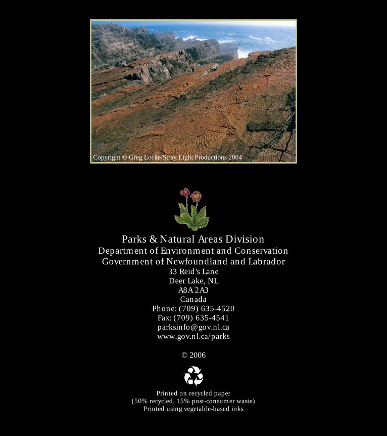
Parks & Natural Areas Division Department of Environment and Conservation Government of Newfoundland and Labrador
33 Reid’s Lane Deer Lake, NL
A8A 2A3 Canada
Phone: (709) 635-4520 Fax: (709) 635-4541 [email protected] www.gov.nl.ca/parks
© 2006
Printed on recycled paper (50% recycled, 15% post-consumer waste)
Printed using vegetable-based inks
Copyright © Greg Locke/Stray Light Productions 2004