A GML-Based Open Architecture for Building A Geographical
33
A GML-Based Open Architecture for Building A Geographical Information Search Engine Over the Internet Jianting Zhang Le Gruenwald School of Computer Science The University of Oklahoma U.S.A. [email protected]
Transcript of A GML-Based Open Architecture for Building A Geographical

A GML-Based Open Architecture for Building A Geographical Information Search Engine
Over the Internet
Jianting ZhangLe Gruenwald
School of Computer ScienceThe University of Oklahoma

Table of Contents
IntroductionObjectivesExisting GRI Searching Engines: problem and proposeGeographical Markup Language: a Simple Illustration
Proposed Architecture and A Prototype Implementation
System ArchitectureMotivation of the PrototypeSoftware Agents for Collecting GRI over the InternetGML Wrappers for RDBMS and ORDBMSSpatial-Enabled MediatorClient Query and Visualization
Conclusion and Future work direction

Research Objectives
Propose an open architecture for building a geographical information search engine over the Internet
Develop a proof-of-concept prototype using University of Oklahoma’s student contact information list
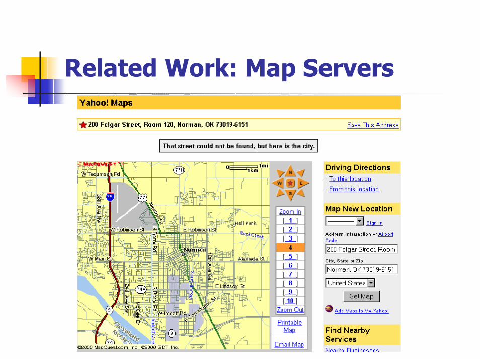
Related Work: Map Servers

Related Work: Google Search

Related Work: Google Search

Related Work: Alexandria Digital Library Gazetteer at UCSB

Problems with Current Solutions
•Full text search does not work well for Geo-Referenced Information (GRI)
•Proprietary data and software introduce integration and interoperability problems
•Centralized GRI data management does not match its distributed nature and application requirements

Proposed Solution
GRI Transformation
-- Geocoding
Interoperability:
--GML
Distributed and Heterogeneous Data Management:
--Wrapper/Mediator

What is Geographical Markup Language (GML)?
• GML is an extension to XML
• GML defines XML representations of geographical features, such as Point, Polyline and Polygon.
• GML is standardized by OGC (Open GIS Consortium)
• Current version is 2.0 released on Feb. 20th, 2001
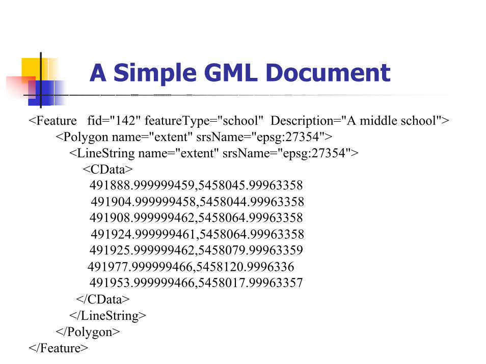
A Simple GML Document
<Feature fid="142" featureType="school" Description="A middle school"><Polygon name="extent" srsName="epsg:27354">
<LineString name="extent" srsName="epsg:27354"><CData>
491888.999999459,5458045.99963358 491904.999999458,5458044.99963358491908.999999462,5458064.99963358 491924.999999461,5458064.99963358491925.999999462,5458079.99963359491977.999999466,5458120.9996336491953.999999466,5458017.99963357
</CData></LineString>
</Polygon></Feature>
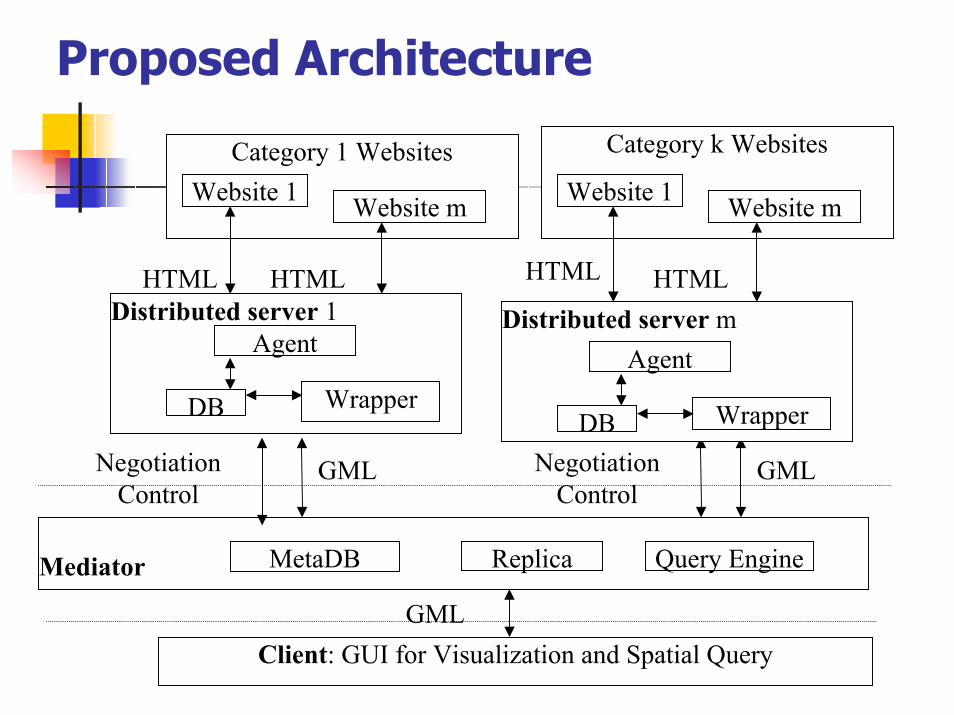
Proposed Architecture
Distributed server 1
Website 1 Website m
DB Wrapper
Agent
HTMLHTML
Client: GUI for Visualization and Spatial QueryGML
Mediator MetaDB Replica Query Engine
Category 1 WebsitesWebsite 1 Website m
HTMLHTML
Distributed server m
DB Wrapper
Agent
Category k Websites
GMLNegotiationControl
GMLNegotiationControl

Advantages of Proposed Architecture
•Distributed: it allows small and specialized software agents to search for region/domain specific GRI over the Internet and makes the search result reusable.
•Open: any system supports GML can make use of the result from search agents and integrate it into its own application to provide new value-added services.
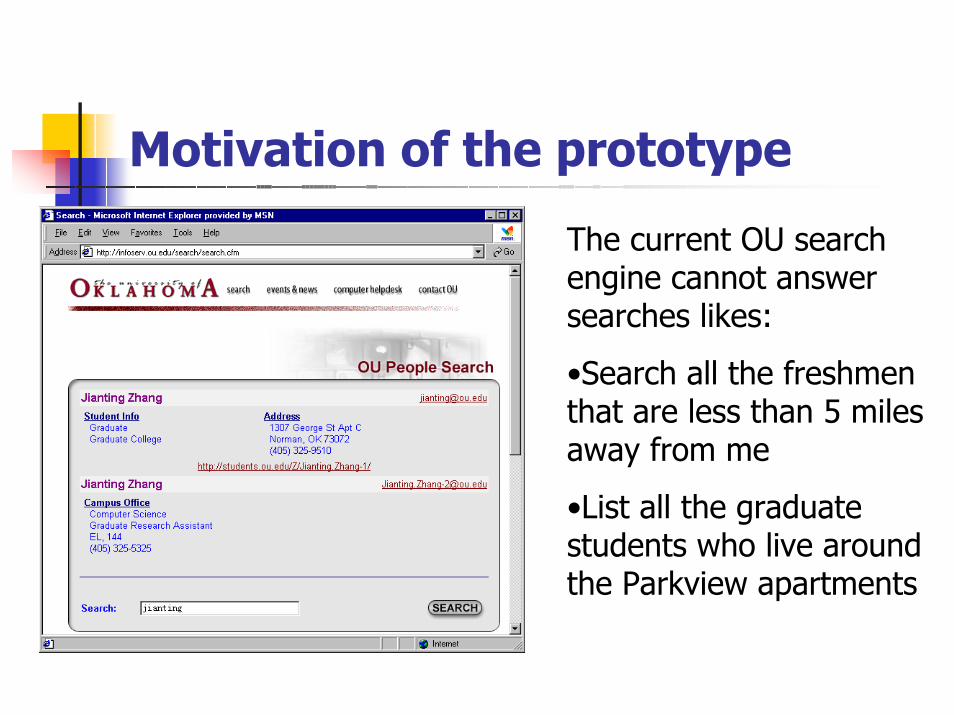
Motivation of the prototype
The current OU search engine cannot answer searches likes:
•Search all the freshmen that are less than 5 miles away from me
•List all the graduate students who live around the Parkview apartments

Prototyping Based on the Architecture
We need to materialize the four components in the proposed architecture:
Software agents to collect GRI over the Web pages
GML Wrapper for Flat File, RDBMS and ORDBMS
Spatial-Enabled Mediator
Client Query and visualization GUI

Prototype Design•Two distributed servers.
•SQL Server 2000/Retrieve the information of students whose surname begin with a letter ‘A’ (198)
•Oracle 8i /Retrieve the information of students whose surname begin with a letter ‘B’ (519)
•One Mediator Server using Oracle 8i
•One Web Server hosting Client Visualization Java Classes
Two types of Base Map Servers (Wrappers)
•ESRI ShapeFile
•Oracle 8i

Experiment Environment
Operating System: Windows NT 4.0
Web Server: Java Server Web Development Kit (JSWDK) 1.0
Client Browser: Internet Explore 5.5
Java Complier and Runtime: SUN JDK SE 1.3
Application Servers by using Virtual Directories:
•Distributed Server 1 (Wrapper for SQL Server 2000)
•Distributed Server 2 (Wrapper Oracle 8i)
•Base Map Servers (Wrapper for Flat File/DBMS)

Building the Agents using Java Swing HTML Parser
Open an URLConnection for a given URL
Open an InputStreamReader to read the HTML page
Build an HTMLEditorKit to process the HTML page
Create a Document from the kit to represent the page
Bind InputStreamReader and Document using HTMLEditorKit
Go through the hierarchy of HTML document tree
Get tag name, tag values and textual data

Building the Agents using Java Swing HTML Parser (Cont.)
Parse the textual data
Name, email,status, college Street address, city, state, zip
longitude/latitude
Address Info
Geocoding
Validation
Phone
File/Database update
End

Geocoding: An Example
Tanya Babarykina [email protected] Senior College of Business 402 Wadsack Dr E Norman, OK 73072(405) 325-9282
(-97.443067,35.194425)
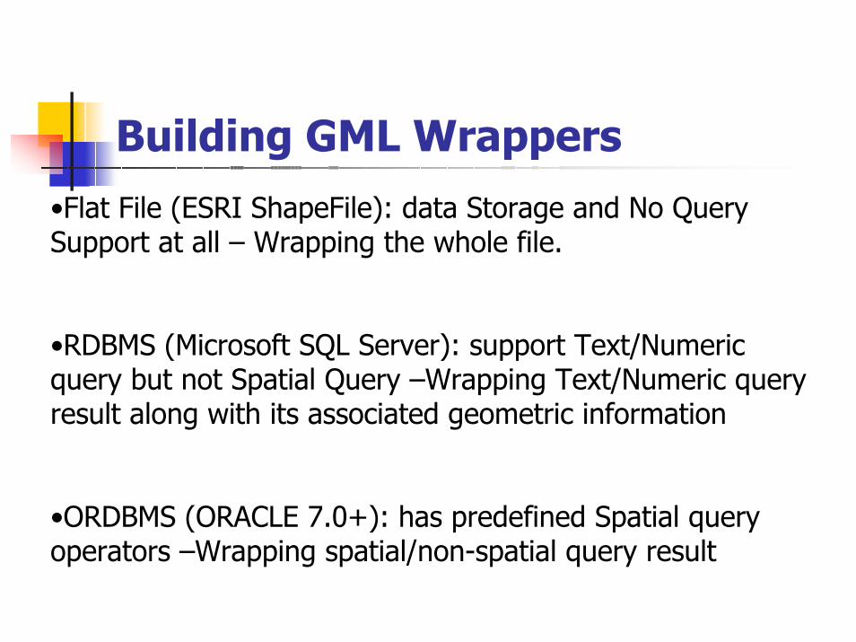
Building GML Wrappers•Flat File (ESRI ShapeFile): data Storage and No Query Support at all – Wrapping the whole file.
•RDBMS (Microsoft SQL Server): support Text/Numeric query but not Spatial Query –Wrapping Text/Numeric query result along with its associated geometric information
•ORDBMS (ORACLE 7.0+): has predefined Spatial query operators –Wrapping spatial/non-spatial query result

Building GML Wrapper (Cont)
Loop Through GRI records in File/DBMS
Create New GML Document
Switch type:
Point
CreateElement
CreateAttributeCreateElement (Clist for Geometric Data)
Append Node to GML Document
PolylinePolygon
Output the Generated GML Document

Building GML Wrapper: An Example from Oracle ORDBMS

Building the Mediator
Client Request
Send request to distributed server
Check last update time
Spatial Query Support?
Send sub-request to distributed server
Break down the query into queries for individual distributed servers involved
Is update needed?
Yes
Yes
No
For each distributed server
1 2
4
3
No

Building the Mediator (Cont.)
Send request to distributed server
Update Mirror Database in Mediator with returned GML document
Query on mirrored database in the mediator
23
Transfer the returned GML document into
XML nodes
1
Transfer query result into XML nodes
Output the Generated XML Document
Combine all the XML nodes and associated metadata information
4
End

Client Side Spatial Query and Visualization
GeoTools: Open Source Java Package From University of Leeds, UK
Base Map: Spatial Query Result From Oracle/Flat File
Thematic Search Result From Mediator

Client Side Spatial Query and Visualization: National Scale

Client Side Spatial Query and Visualization: State Scale

Client Side Spatial Query and Visualization: County Scale

Client Side Spatial Query and Visualization: City Scale

Summaries
We have proposed an open architecture for building GRI search Engine over the Internet
We have built GML wrappers for Flat File, Pure Relational DBMS and Object-Relational DBMS
We have built a mediator server with full spatial query capability using Oracle Spatial functionalities
We have built client visualization functions for query results using the open source package GeoTools
Future Directions
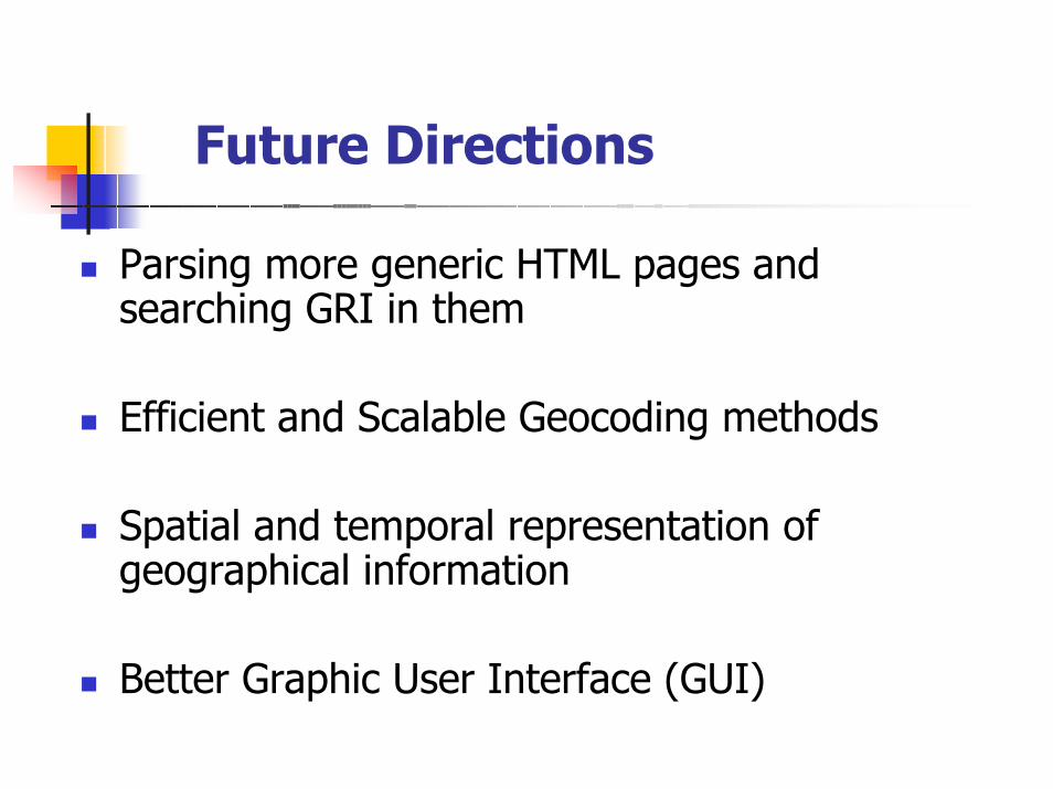
Parsing more generic HTML pages and searching GRI in them
Efficient and Scalable Geocoding methods
Spatial and temporal representation of geographical information
Better Graphic User Interface (GUI)

Thanks !
Questions?