Individual based models by using GIS and a wildlife auto tracking
A GIS PLAN TO PROTECT FISH AND WILDLIFE RESOURCES … · A GIS PLAN TO PROTECT FISH AND WILDLIFE...
16
A GIS PLAN TO PROTECT FISH AND WILDLIFE RESOURCES IN THE BIG BEND AREA OF FLORIDA Randy Kautz, Terry Gilbert, and Beth Stys Florida Fish and Wildlife Conservation Commission Tallahassee, Florida Abstract The Northern Extension of the Florida Turnpike (NEFT) and the Suncoast Expressway are two proposed limited access highways that would connect south Florida and the Tampa Bay area to U.S. 19, the major roadway running through the coastal Big Bend area of north Florida. The parties to a mediation process designed to resolve conflicts over the siting of the NEFT recognized that these new highways will result in a substantial increase in traffic through the rural Big Bend region. In turn, increased traffic is likely to have secondary impacts on the region=s biological resources as a result of increased tourism, the need for new motels and convenience stores, a higher demand for weekend homes, etc. One result of the mediation process was that the parties signed a multi-agency agreement that established a working group whose charge was to Aidentify the means to protect the integrity of US 19 as an interregional route and to prevent secondary impacts within the US 19 corridor due to increased development pressures.@ The coastal Big Bend region of Florida is one of this state=s most rural and remote areas, where the local economy is dominated by timber, agriculture, commercial and recreational fishing, and tourism. The region=s large inland freshwater swamps, river floodplains, wet pinelands, and hardwood forests drain to the productive estuarine systems of the Gulf of Mexico. These native habitats support important marine fisheries and valuable wildlife resources including the Florida black bear. This project was an attempt to use existing geographic information system (GIS) data layers to identify sensitive biological and ecological resources that may be threatened by increased growth. Specific resources mapped as part of the project include nearshore seagrass beds; buffers along freshwater streams and wetlands draining to the Gulf; coastal buffer zones; endangered, threatened, and rare species habitats; Florida black bear habitat and road kill locations; and public lands. This information was assembled into a common GIS database and distributed on CD-ROM for use with ArcView GIS 8 software. In addition, a set of recommendations was developed for the protection of the region=s ecological resources. This information is being assembled into a final report that will be submitted to the Florida Governor=s Office for implementation by state agencies involved in public land acquisition, land use planning, development regulation, public land management, private landowner incentives, and transportation planning. By identifying sensitive ecological resources early in the road planning process, public agencies and private citizens are in a better position to successfully protect important natural lands, and direct growth away from environmentally sensitive areas. Introduction Florida currently has an estimated population of 15.2 million people, and by 2025 the population is projected to grow to 20.7 million (Campbell 1996). If these projections hold true, Florida will go from the 4 th to the 3 rd most populous state in the nation in the next 25 years. In addition to the resident population, Florida is host to an estimated 42 million tourists each year (Winsberg 1992). Moreover, the state=s highways accommodate a large volume of truck traffic transporting freight for interstate and intrastate commerce. The huge numbers of people living in Florida, visiting the state, or transporting goods each year place a tremendous traffic load on the state=s crowded highways. To meet current and future demand, transportation planners are constantly developing and implementing plans for new transportation facilities. Over the last decade, two new interstate-level highway segments have been proposed for the north-central portion of the Florida peninsula: the northern extension of the Florida turnpike (NEFT) and the Suncoast Expressway (Figure 1). The NEFT would extend the Florida turnpike for about 65 km (40 miles) from its current terminus at Wildwood in central Florida and would link with US 19, the principal north-south artery along Florida=s west coast. The principal purpose for the NEFT is to alleviate traffic on I-75 in northern Florida. The Suncoast Expressway would parallel US 19 from Tampa north for a distance of 103 km (64 miles), linking up with US 19 approximately 24 km (15 miles) south of the proposed terminus of NEFT. The purpose of the Suncoast expressway is to alleviate traffic on the heavily congested US 19 from Tampa to Crystal River. These new highways would also improve ground transportation between the American Midwest and Central and South Florida. Once completed in about 10 years, these new highways are expected to generate a large increase in traffic on US 19 through the rural and ecologically sensitive Big Bend region of north Florida. Not only will these highways facilitate travel from other parts of the nation to south Florida, they will also improve recreational access to the extensive natural areas of the Big Bend region by residents of central and south Florida. In turn, increased traffic and improved recreational access may be expected to result in secondary growth and adverse cumulative impacts on the region=s ecological resources. New gas stations, convenience stores, shopping centers, restaurants, motels, second homes, roads, etc., will need to be constructed to serve the needs of travelers, tourists, and new residents over the next 25 years. These issues came to light during a multi-agency mediation process designed to resolve conflicts that arose over the siting of the NEFT. One result of the mediation process was that the affected agencies signed an agreement that established a working group whose charge was to Aidentify the means to protect the integrity of US 19 as an interregional route and to prevent secondary impacts within the US 19 corridor due to increased development pressures.@ Our responsibility in the working group was to identify the important biological and ecological resources that are priorities for protection in the Big Bend region. The intent was that the results of this study could be used to begin planning for the growth of this region in an environmentally sound manner before these new transportation projects come on line in the next 10 years. Once important areas are identified, land use planners will have a 10 year window in which to educate local governments as to the resource values of their area and the impacts that are likely to occur, and to set in place the land use plans, local ordinances, and other tools needed to direct growth in a manner that preserves the biological diversity of the region. The study used geographic information system (GIS) technology and existing databases to prepare maps of high priority ecological resources for protection. Study Area Description For the purposes of this study, the Big Bend region of Florida includes all of Levy, Gilchrist, Dixie, Lafayette, Taylor, Madison, and Jefferson counties (Figure 2), the seven counties most affected by the expected increase in traffic along US 19. The region is one of the most rural and remote areas remaining in the state, with urban areas accounting for only 5.2% (Table 1). The local economy is dominated by timber and forest products, agriculture, commercial and recreational fishing, and tourism. The area is characterized by diverse plant communities and habitat types. Wetlands cover 33% of the landscape (Table 1) and include hardwood and cypress (Taxodium spp.) swamps, bayheads, freshwater marshes, hydric hardwood hammocks, pond pine (Pinus serotina) flatwoods, and coastal salt marsh. Many upland areas have been converted to planted slash pines (P.
Transcript of A GIS PLAN TO PROTECT FISH AND WILDLIFE RESOURCES … · A GIS PLAN TO PROTECT FISH AND WILDLIFE...

A GIS PLAN TO PROTECT FISH AND WILDLIFE RESOURCESIN THE BIG BEND AREA OF FLORIDA
Randy Kautz, Terry Gilbert, and Beth StysFlorida Fish and Wildlife Conservation Commission
Tallahassee, Florida
AbstractThe Northern Extension of the Florida Turnpike (NEFT) and the Suncoast Expressway are two proposed limited access highways that
would connect south Florida and the Tampa Bay area to U.S. 19, the major roadway running through the coastal Big Bend area of north Florida. Theparties to a mediation process designed to resolve conflicts over the siting of the NEFT recognized that these new highways will result in a substantialincrease in traffic through the rural Big Bend region. In turn, increased traffic is likely to have secondary impacts on the region=s biological resourcesas a result of increased tourism, the need for new motels and convenience stores, a higher demand for weekend homes, etc. One result of the mediationprocess was that the parties signed a multi-agency agreement that established a working group whose charge was to Aidentify the means to protect theintegrity of US 19 as an interregional route and to prevent secondary impacts within the US 19 corridor due to increased development pressures.@ The coastal Big Bend region of Florida is one of this state=s most rural and remote areas, where the local economy is dominated by timber,agriculture, commercial and recreational fishing, and tourism. The region=s large inland freshwater swamps, river floodplains, wet pinelands, andhardwood forests drain to the productive estuarine systems of the Gulf of Mexico. These native habitats support important marine fisheries andvaluable wildlife resources including the Florida black bear. This project was an attempt to use existing geographic information system (GIS) datalayers to identify sensitive biological and ecological resources that may be threatened by increased growth. Specific resources mapped as part of theproject include nearshore seagrass beds; buffers along freshwater streams and wetlands draining to the Gulf; coastal buffer zones; endangered,threatened, and rare species habitats; Florida black bear habitat and road kill locations; and public lands. This information was assembled into acommon GIS database and distributed on CD-ROM for use with ArcView GIS8 software. In addition, a set of recommendations was developed for theprotection of the region=s ecological resources. This information is being assembled into a final report that will be submitted to the FloridaGovernor=s Office for implementation by state agencies involved in public land acquisition, land use planning, development regulation, public landmanagement, private landowner incentives, and transportation planning. By identifying sensitive ecological resources early in the road planningprocess, public agencies and private citizens are in a better position to successfully protect important natural lands, and direct growth away fromenvironmentally sensitive areas.
IntroductionFlorida currently has an estimated population of 15.2 million people, and by 2025 the population is projected to grow to 20.7 million
(Campbell 1996). If these projections hold true, Florida will go from the 4th to the 3rd most populous state in the nation in the next 25 years. Inaddition to the resident population, Florida is host to an estimated 42 million tourists each year (Winsberg 1992). Moreover, the state=s highwaysaccommodate a large volume of truck traffic transporting freight for interstate and intrastate commerce. The huge numbers of people living in Florida,visiting the state, or transporting goods each year place a tremendous traffic load on the state=s crowded highways. To meet current and futuredemand, transportation planners are constantly developing and implementing plans for new transportation facilities.
Over the last decade, two new interstate-level highway segments have been proposed for the north-central portion of the Florida peninsula:the northern extension of the Florida turnpike (NEFT) and the Suncoast Expressway (Figure 1). The NEFT would extend the Florida turnpike forabout 65 km (40 miles) from its current terminus at Wildwood in central Florida and would link with US 19, the principal north-south artery alongFlorida=s west coast. The principal purpose for the NEFT is to alleviate traffic on I-75 in northern Florida. The Suncoast Expressway would parallelUS 19 from Tampa north for a distance of 103 km (64 miles), linking up with US 19 approximately 24 km (15 miles) south of the proposed terminusof NEFT. The purpose of the Suncoast expressway is to alleviate traffic on the heavily congested US 19 from Tampa to Crystal River. These newhighways would also improve ground transportation between the American Midwest and Central and South Florida.
Once completed in about 10 years, these new highways are expected to generate a large increase in traffic on US 19 through the rural andecologically sensitive Big Bend region of north Florida. Not only will these highways facilitate travel from other parts of the nation to south Florida,they will also improve recreational access to the extensive natural areas of the Big Bend region by residents of central and south Florida. In turn,increased traffic and improved recreational access may be expected to result in secondary growth and adverse cumulative impacts on the region=secological resources. New gas stations, convenience stores, shopping centers, restaurants, motels, second homes, roads, etc., will need to beconstructed to serve the needs of travelers, tourists, and new residents over the next 25 years.
These issues came to light during a multi-agency mediation process designed to resolve conflicts that arose over the siting of the NEFT. One result of the mediation process was that the affected agencies signed an agreement that established a working group whose charge was toAidentify the means to protect the integrity of US 19 as an interregional route and to prevent secondary impacts within the US 19 corridor due toincreased development pressures.@ Our responsibility in the working group was to identify the important biological and ecological resources that arepriorities for protection in the Big Bend region. The intent was that the results of this study could be used to begin planning for the growth of thisregion in an environmentally sound manner before these new transportation projects come on line in the next 10 years. Once important areas areidentified, land use planners will have a 10 year window in which to educate local governments as to the resource values of their area and the impactsthat are likely to occur, and to set in place the land use plans, local ordinances, and other tools needed to direct growth in a manner that preserves thebiological diversity of the region. The study used geographic information system (GIS) technology and existing databases to prepare maps of highpriority ecological resources for protection.
Study Area DescriptionFor the purposes of this study, the Big Bend region of Florida includes all of Levy, Gilchrist, Dixie, Lafayette, Taylor, Madison, and
Jefferson counties (Figure 2), the seven counties most affected by the expected increase in traffic along US 19. The region is one of the most rural andremote areas remaining in the state, with urban areas accounting for only 5.2% (Table 1). The local economy is dominated by timber and forestproducts, agriculture, commercial and recreational fishing, and tourism. The area is characterized by diverse plant communities and habitat types. Wetlands cover 33% of the landscape (Table 1) and include hardwood and cypress (Taxodium spp.) swamps, bayheads, freshwater marshes, hydrichardwood hammocks, pond pine (Pinus serotina) flatwoods, and coastal salt marsh. Many upland areas have been converted to planted slash pines (P.

elliottii) by the forest industry, and pine plantations are now the predominant land use in the region, accounting for 37% of the landscape (Table 1). Natural uplands communities, such as sandhills, mesic and xeric hardwood hammocks, xeric oak (Quercus spp.) scrub, and sand pine scrub (P.clausa), once accounted for 37% but now cover only 12% of the Big Bend (Table 1). Sandhills, which historically covered 17% of the region, havebeen reduced to only 0.27% of the area.
The principal streams flowing through or draining the region include the Suwannee, Econfina, Steinhatchee, Aucilla, and Waccassa rivers. These rivers drain uplands and large forested wetlands to the Apalachee Bay and Gulf of Mexico along the coast of Jefferson, Taylor, Dixie and Levycounties. The entire coastline of the region is fringed by a vast salt marsh system dominated by black needelrush (Juncus roemerianus). The watersof Apalachee Bay are very shallow and slope very gradually to deeper offshore waters of the Gulf of Mexico. The clear waters and shallow bottoms ofApalachee Bay support an extensive and productive seagrass bed system that is second in area only to Florida Bay.
The native habitats of the Big Bend support a diverse and valuable array of fish and wildlife. Estuarine areas directly support importantsport and commercial marine fisheries for spotted seatrout (Cynoscion nebulosus), red drum (Sciaenops ocellatus), gulf flounder (Paralichthysalbigutta), striped mullet (Mugil cephalus), bay scallops (Argopecten irradians), oysters (Crassostrea virginica), blue crabs (Callinectes sapidus),and stone crabs (Menippe mercenaria). Also, a successful and growing commercial aquiculture fishery for clams (Mercenaria spp.) has beenestablished in several areas. The large swamps, hardwood hammocks, and pinelands provide prime habitat for game animals including the white-tailed deer (Odocoileus virginiana), wild turkey (Meleagris gallopavo), and gray squirrel (Sciurus carolinensis). Important habitat is also providedfor many rare species and others listed by the Florida Fish and Wildlife Conservation Commission as endangered, threatened, or species of specialconcern including the Florida black bear (Ursus americana flordidanus), red-cockaded woodpecker (Picoides borealis), Florida scrub jay(Aphelocoma coerulescens), and wood stork (Mycteria americana) (Table 2).
Geographic Information System Data LayersGeographic information system (GIS) technology was used for the task of identifying and prioritizing ecological resources likely to be at
risk from the secondary and cumulative impacts of these two new expressways in north Florida. For this project, all GIS analyses were performedusing ArcView GIS8 3.1 and the ArcView Spatial Analyst8 1.1 extension. Most of the analyses were performed using raster databases and rastermodeling techniques. A large number of GIS databases is available that characterize the biological and ecological resources of the state. AvailableGIS databases used in this project are described below.
Land Cover and VegetationA raster database of vegetation and landcover for the state of Florida (Kautz et al. 1993) was used as the source of vegetation information.
This database, created from 1985-89 Landsat Thematic Mapper imagery, contains 22 land cover classes. Pixel size is 30 m.
Potential Wildlife Habitat ModelsCox et al. (1994) and J. Cox (unpublished manuscript) created potential habitat models for more than 150 species of Florida wildlife. The
species for which potential habitat models have been created include (1) all Florida vertebrates listed as endangered species, threatened species, orspecies of special concern by the State of Florida or the federal government (Logan 1997), (2) all Florida vertebrates listed as endangered, threatened,species of special concern, rare, or status undetermined by the Florida Committee on Rare and Endangered Plants and Animals (Humphrey 1992,Moler 1992, Rodgers et al. 1996), and (3) species given a biological score of >24 by Millsap et al. (1990). All models use 109 m pixels to depict themost likely locations of habitat for each species on a statewide basis. Class codes in the data set are either 0 (i.e., no habitat) or 1 (i.e., potentialhabitat). A variety of techniques was used to create each of the potential habitat models. The sources of input data included occurrence records fromthe Florida Natural Areas Inventory, occurrence records from the Florida Fish and Wildlife Conservation Commission=s wildlife observation database,the Florida breeding bird atlas database (Kale et al. 1992), the vegetation data of Kautz et al. (1993), unpublished records from species experts, rangemaps, and habitat requirements information obtained from the scientific literature. The Big Bend region supports 55 species of wildlife meeting theconditions described above (Table 2), and habitat models are available for most.
Strategic Habitat Conservation AreasCox et al. (1994) identified 4.82 million acres of land in Florida that they referred to as Strategic Habitat Conservation Areas (SHCA).
SHCAs are privately owned lands that should be protected to ensure the long-term persistence of most components of biodiversity in Florida. Cox etal. (1994) used GIS to create potential habitat maps for a set of focal species of wildlife that were used as indicators of biodiversity. The focal specieswere evaluated for how well their habitats were already protected on public lands. SHCAs are presumed to be high priorities for protection ofbiological diversity in Florida.
Seagrass BedsVector coverages for the locations of seagrass beds in the nearshore waters of the Gulf of Mexico were obtained from the Florida Fish and
Wildlife Conservation Commission, Florida Marine Research Institute, Atlas of Marine Resources, Version 1.2 (1998).
Political BoundariesU.S. Geological Survey (USGS) Digital Line Graph (DLG) vector coverages, digitized from 1:100,000 scale quadrangle maps for the state
of Florida, were used for political boundaries.
RoadsVector coverages for the road network for the region were obtained from the Florida Department of Transportation. The base map for the
line work is unknown.
Black Bear Roadkill LocationsSince 1976, the Florida Fish and Wildlife Conservation Commission has been collecting information on the locations, age, and sex of
Florida black bears killed on highways as a result of collisions with motor vehicles. This database has been digitized and is used to identify specificstretches of highway where roadway mortality is a problem for the black bear (Gilbert and Wooding 1996).
Public Lands and Lands Proposed for Public AcquisitionThe state of Florida has a very active program for the acquisition and management of public lands. The Florida Natural Areas Inventory
(FNAI), the unit of The Nature Conservancy responsible for maintaining Florida=s natural heritage database, is under contract to the state of Florida

to maintain statewide vector coverages of the boundaries of lands in public ownership, lands in private ownership dedicated to conservation uses, andprivately owned lands proposed for public acquisition. Boundaries of conservation lands and lands proposed for acquisition are typically digitizedfrom 1:24,000 scale USGS topographic maps.
Private Landowner BoundariesIn pursuing biodiversity conservation needs on privately owned lands, it is often easier to deal with a few large private landowners than
many owners of small parcels. For this reason, Cox et al. (1994) digitized the boundaries of privately owned lands 130 ha (>320 acres) for 57 Floridacounties, including six of the seven counties in the Big Bend study area. Parcel boundaries were transferred by hand from commercially available platbooks to 1:126,700 scale county highway maps and then digitized (Cox et al. 1994), but landowner names were not included as an attribute of theboundaries. For this project, the original linework of Cox et al. (1994) was overlaid on the USGS DLG Public Land Survey System coverage for theseven-county study area, and the private landowner boundaries were rectified to the vector coverage and updated using the most recent plat booksavailable. Then, the names of landowners for the parcels >130 ha (>320 acres) in size were added as an attribute of the boundaries. A completelynew set of parcel boundaries and landowner names was created for Jefferson County which was not included in the original data set of Cox et al.(1994). The purpose for this part of the project was to facilitate landowner contacts for eventual users of the database.
HydrographyVector coverages of streams were obtained from the U.S. Environmental Protection Agency (EPA) river reach file version 3.0 (RF3-
Alpha). This data set originated as the hydrography coverage in the USGS 1:100,000 scale DLG files for Florida, but was modified by EPA such thatriver reaches are now identified with specific river reach identification numbers, and each river reach is defined by nodes placed at the confluence ofeach tributary to the stream.
Identification of Important Ecological ResourcesThe GIS data layers described above were used to identify the important ecological areas of the Big Bend region that should be protected
from the secondary impacts of increased traffic expected to occur from the completion of the NEFT and Suncoast Expressway. The principalecological resources of concern include nearshore seagrass beds, streams and wetlands, habitats of rare and imperiled wildlife, and habitat for theFlorida black bear. The methods used to identify important areas for each of these components of biodiversity are described in the following sections.
Big Bend Seagrass BedsAmong the most valuable ecological resources of the Big Bend area are the extensive marine seagrass beds found in the nearshore waters of
the Gulf of Mexico. Seagrass beds provide critical habitat for many estuarine and marine species of recreational and commercial importance(Livingston 1990). Recreational fishing is a prime attraction of the Big Bend area, and healthy seagrass beds are integral to the sustainability ofnature-based tourism in the region.
The key factor in maintaining healthy seagrass beds is water quality, particularly with respect to water clarity and nutrients. The quality ofwaters overlying the seagrass beds is most influenced by the quality of upland runoff reaching the coast via the streams and rivers draining the region. Thus, maintenance of water quality in the area=s rivers and streams is imperative. To protect in-stream water quality, development should beprecluded from stream banks to avoid increases in turbdity and nutrients entering the streams. In addition, wetlands contiguous with streams drainingto the Gulf of Mexico should be protected from development because they not only are a major source of water to area streams but also function tofilter nutrients, pollutants, and sediments from upland runoff.
Brown et al. (1990) conducted an exhaustive review of the functions of streamside buffer zones for natural communities in east centralFlorida similar to those found in the Big Bend region. Brown et al. (1990) found that buffer zones in the range of 30-170 m would (1) minimize theeffects of groundwater drawdown resulting from ditching near streams, (2) control sedimentation of streams and wetlands, and (3) protect wildlifehabitat. With respect to wildlife habitat protection, further studies have indicated that buffer zones of 73 m and 275 m are needed to protect 90% and100%, respectively, of turtle nest sites around wetlands (Burke and Gibbons 1995), buffer zones of 164 m around wetlands should protect 95% of theupland habitats required by salamanders (Semlitsch 1998), and streamside management zones 40-140 m wide, but averaging 100 m wide (i.e., 50 mon either side of a stream), support high densities of gray squirrels (Warren and Hurst 1980). Riparian buffer strips also function as movementcorridors for forest birds and several species of rodents (Machtans et al. 1996), but no buffer widths have been recommended as optimal to provide forthe movement needs of birds and mammals.
Based on these reviews of the literature, we concluded that an upland buffer zone of 100 m around all wetlands and along all streams thatdrain to the Gulf of Mexico should be sufficient to protect water quality and quantity in these systems. Maintenance of in-wetland and in-stream waterquality and quantity should, in turn, provide water quality protection to nearshore seagrass beds, thereby preserving their ecological values. Inaddition, 100 m buffers also provide a variety of benefits for many species of wildlife.
Our GIS model of areas that need to be protected to maintain the quality of offshore waters employed the following steps:
1. All streams draining to the Gulf of Mexico in the Big Bend study area were extracted from the EPA river reach file.2. The vegetation map of Kautz et al. (1993) was reclassified such that only wetlands remained.3. The EPA river reach file was intersected with the wetlands map, and contiguous wetlands intersecting the streams were retained. The
purpose of this step was to isolate only wetlands and associated streams that drain to the Gulf of Mexico as priorities for water qualityprotection.
4. A 100 m buffer was placed on either side of all streams and around the margins of all wetlands that drain to the Gulf of Mexico. Thepurpose of this step was to identify buffer areas that should be protected from development in order to ensure in-stream water quality,maintain existing flows, and provide for wildlife habitat needs.
In addition to protecting streams and wetlands that drain to the Gulf of Mexico, an upland buffer along the entire length of the coast wouldalso be helpful in protecting the water quality of the seagrass beds from developments that might eventually occur immediately along the coast. Unfortunately, we could find no hard data to indicate how wide a coastal buffer should be to protect offshore grassbeds. In the absence of hard data,we looked to the St. Marks National Wildlife Refuge (NWR) in Jefferson and adjacent Wakulla County as an example of a coastal buffer that seemsto provide adequate water quality protection. St. Marks NWR has a land area of 26,044 ha (64,239 acres) and extends along the shoreline ofApalachee Bay for a distance of about 51 km (32 miles). Water quality offshore of the St. Marks NWR remains high, and the seagrass beds areproductive. The refuge maintains upland habitats immediately inland of the coast in a relatively natural condition, apparently producing naturallyhigh quality waters in the streams flowing through the refuge and discharging to the Gulf of Mexico. The northern boundary of St. Marks NWR

extends an average of 2.4 km (1.5 miles) inland from the salt marsh/upland forest interface. Using the St. Marks NWR case as a model for success, wepropose a coastal buffer of 2.4 km (1.5 miles) extending inland from the edge of the salt marsh along the entire length of the Big Bend study area. Ourmodel for a 2.4 km (1.5 mile) coastal buffer was created using the following steps:
1. The vegetation map of Kautz et al. (1993) as used to locate the line separating salt marsh and upland plant communities.2. The line identified in Step 1 was buffered inland for a distance of 2.4 km (1.5 miles) to define the landward limits of the coast buffer
strip.
While most of the shoreline along the Big Bend coast already is in public ownership, the proposed coastal buffer would protect theremaining undeveloped areas immediately along the coast from future development and potential adverse impacts to water quality.
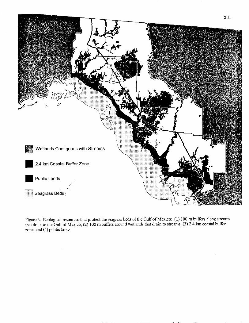
In summary, the quality of waters overlying the seagrass beds of the Big Bend region could be protected by the following: (1) a 100 mbuffer along all streams draining to the Gulf of Mexico, (2) a 100 m upland buffer surrounding all wetlands contiguous with streams that drain to theGulf, and (3) a 2.4 km (1.5 mile) coastal buffer extending inland from the salt marsh/upland interface. These ecological resources are depicted inFigure 3. The best methods for protection of these areas would be through regulations pertaining to dredging and filling and through comprehensiveland use planning to protect upland buffers.
Endangered SpeciesThree species of wildlife listed as endangered by the state of Florida and the U.S. Fish and Wildlife Service inhabit the seven-county study
area: wood stork, peregrine falcon, and saltmarsh vole (Logan 1997). Species are listed as endangered when their populations are so low that thespecies are considered to be in imminent danger of extinction. Of the three endangered species occurring in the study area, wood storks are of greatestconcern. Wood storks nest colonially and forage in wetlands within 30 km of colony sites during the nesting season. Since habitat loss is the principalthreat to wood storks, all wetlands within 30 km of nesting colonies need to be protected to ensure long-term nesting success and survival of woodstorks. Using these features of wood stork life history, Cox et al. (1994) mapped the critical habitats of wood storks throughout Florida. The map ofcritical wood stork habitats is incorporated into our map of important ecological resources for the Big Bend region under the assumption that woodstork are an important species that cannot tolerate additional habitat loss. Many of the wetlands needed by wood storks are included within thewetlands that should be protected to maintain water quality of the seagrass beds.
The habitat protection needs of the other two endangered species that occur in the study area are minimal. Peregrine falcons occur in theregion only during spring and fall migration and throughout the winter months. During these times, they prey primarily on shorebirds congregating onoyster bars, mud bars, tidal flats, and sand beaches immediately along the coast. Most of these habitats are already in public ownership, so noadditional habitat protection is needed for peregrine falcons. The Florida salt marsh vole is found only in a small area of salt marsh wetlands nearCedar Key. While these wetlands are not in public ownership, the sites could be protected from development impacts through development regulationor comprehensive land use planning. The protection of coastal salt marshes as part of a seagrass bed protection plan would also protect salt marsh volehabitat.
Threatened Species, Species of Special Concern, and Rare Nongame WildlifeAdditional species of wildlife of concern in the Big Bend region include 10 species listed as threatened, 16 species listed as species of
special concern, and 26 rare species of nongame wildlife. These 52 species, plus the three endangered species discussed above (Table 2), include alltaxa of vertebrates found in the study area that have been identified as having some kind of conservation need (Millsap et al. 1990, Humphrey 1992,Moler 1992, Rodgers et al. 1996, Logan 1997). To identify important habitats needed to protect these species in the Big Bend region, the followingsteps were taken:
1. Habitat models for the 10 threatened species (Cox et al. 1994, J. Cox unpublished manuscript) were overlaid to identify areas thatwould support the greatest number of threatened species.
2. Habitat models for the remaining 42 species also were overlaid to identify habitat hot spots for the remaining rare and imperiledvertebrates in the study area..
Step 1 identified the sandhill and scrub habitats of Levy and Gilchrist counties as hot spots for the threatened species of the region. Threatened species are in imminent danger of becoming endangered if current population trends continue, and habitat loss is the principal reason mostof these species are listed as threatened. We presume that the habitats of threatened species constitute ecologically significant resource worthy ofprotection, and, therefore, the sandhill and scrub habitats of Levy and Gilchrist counties are important areas that should be protected from furtherdevelopment. Step 2 resulted in the identification of most remaining areas of natural habitat in the region as supporting at least one rare species. However, habitat hot spots for species of special concern and other rare and imperiled wildlife were primarily in the sandhills and scrubs of Levy andGilchrist counties. Because the habitat modeling for both threatened and other rare and imperiled species of wildlife identified the sandhill and scrubhabitats in the region as hot spots, our map of ecologically significant resources ranks these areas as high priorities for protection (Figure 4).
Florida Black BearThe Florida black bear, listed as threatened by the state of Florida (Logan 1997), presents a special case for protection from the impacts of
secondary development. The black bear is a very mobile, wide-ranging species that requires extensive areas of forested habitat. Home range sizes ofadult males average around 17,000 ha (42,000 acres), and the largest home range size observed in Florida was 45,750 ha (113,000 acres) (Maehr andWooding 1992). The two most significant issues with respect to black bear conservation are habitat loss and roadkill mortality. These issues are dealtwith separately in the following sections.
Black Bear Habitat - The extensive forested uplands and wetlands of the Big Bend region appear to provide a large area of suitable blackbear habitat, yet black bears currently are present only in the western-most portion of the study area. Conjecture has it that black bears have beeneliminated from the region due to past over-hunting. At the present time, the Apalachicola National Forest (NF) 32 km (20 miles) to the west of thestudy area supports the largest population of black bears protected by public lands in Florida (Cox et al. 1994). In recent times, the black bearpopulation of the Apalachicola NF has been expanding to the east, apparently because the population is increasing in response to the termination ofblack bear hunting seasons in Florida. The population increase is evidenced by the increasing number of road-killed black bears in southern JeffersonCounty, the western-most county in the study area.
The significance of certain areas of Jefferson and Taylor counties to the expanding black bear population was recognized by Cox et al.

(1994) who designated these lands as Strategic Habitat Conservation Areas (SHCA) for black bears (Figure 5). Areas designated as SHCAs areprivately owned lands that are the highest priorities for protection in order to ensure that sufficient habitat is available to meet the long-term needs ofblack bears. We presume that the SHCAs identified by Cox et al. (1994) are of prime importance for black bear conservation, and, therefore, theseareas should be included in any map of ecologically significant resources for the study area.
As part of their effort to prioritize black bear habitats for conservation, Cox et al. (1994) created a map of black bear habitat rankedaccording to habitat quality, proximity to public lands, density of roads, and large landownership patterns. The ranked habitat map shows that most ofthe non-urbanized areas of the Big Bend region qualify as black bear habitat (Figure 6). The highest ranked habitats occur between US 19 and theGulf coast. Given the evidence that the black bear population is expanding to the east from Apalachicola NF and that habitats in the Big Bend regionare suitable for black bears, there is value in formulating a conservation plan for black bear habitat to allow bears to eventually reoccupy availablehabitats. In addition, repopulation in the region would eventually allow for a connection with a small isolated population of black bears in theChassahowitzka area immediately to the south of the study area. The principal problem with formulating a habitat conservation plan for black bears isthat there is so much apparently suitable habitat in the region that outright purchase by public agencies is unfeasible. Perhaps the best solution to theconservation of black bear habitat is to maintain the existing landscape for timber production. Methods for accomplishing this are outlined in therecommendations section.
Black Bear Roadkill Mortality - The greatest known source of mortality to black bears is collisions with motor vehicles. The greatestnumber of black bear roadkills in the region in recent years has occurred in Jefferson County along US 19 and along US 98 just west of the AucillaRiver (Figure 5). Increased highway traffic on US 19 will undoubtedly increase the amount of traffic in Jefferson County, thereby increasing thelikelihood of future roadkills along these stretches of road. In addition, if black bears continue to expand into the habitats of the Big Bend region asexpected, there is a greater probability that black bear roadkills will begin to occur throughout the region. One possible way to reduce currentroadkills is to mitigate the impacts of the NEFT and the Suncoast Expressway by constructing bear underpasses at the problem areas of US 98 and US19 in Jefferson County with first priority given to US 98.
Ecological Resource Protection SummaryIn this project, we have attempted to use GIS technology and best available data to identify the important ecological resources of the seven-
county study area of the Big Bend region (Figure 7). These are the areas of highest value that should be protected from the adverse and cumulativeimpacts of secondary development due to the eventual completion of the Northern Extension of the Florida Turnpike and the Suncoast Expressway andthe resultant increase in traffic on US 19. Priorities for protection include: (1) the Big Bend seagrass beds; (2) 100 m buffers around all rivers,streams, and contiguous wetlands that drain to the Gulf of Mexico; (3) a 2.4 km (1.5) mile coastal buffer; (4) habitats of endangered species,especially the wood stork; (5) sandhill and scrub habitats that support large numbers of rare and imperiled species; and (6) Strategic HabitatConservation Areas for black bears in Jefferson and Taylor counties. Habitats of lower priority for protection include the pine flatwoods and forestedwetlands of the region that are primarily in timber use. These areas are important to the wide-ranging black bear and also support many other speciesof wildlife.
Ecological Resource Protection RecommendationsThe ecologically important areas identified in this project can be protected through a variety of techniques. The principal techniques
currently available include land acquisition, land use planning, development regulation, private landowner incentives, and public landmanagement. These techniques could be employed by agencies of state and local governments as they discharge their routine duties over the next 20-30 years. Specific recommendations are listed below.
Land AcquisitionRecommendation 1: Remaining scrub and sandhill habitat in Levy and Gilchrist counties should be acquired by the State. These areas are
the highest priorities for outright purchase as they support the rarest species and most sensitive natural communities in the region, and they are notlikely to be adequately protected through any other means. New land acquisition projects should be designed to protect these areas, and proposalsshould be submitted to agencies currently involved in the State=s various land acquisition programs, including Conservation and Recreation Lands(CARL), Preservation 2000 (P2000), Save Our Rivers (SOR), and Florida Forever.
Recommendation 2: Black bear Strategic Habitat Conservation Areas in Jefferson and western Taylor counties should be acquired by theState. At the present time, these are the most important areas for the black bears in the Big Bend region. Several existing CARL and SOR projects areincluded within this area.
Recommendation 3: Privately owned lands within 2.4 km (1.5 miles) of the coast from Jefferson to Levy county should be acquired by theState. This acquisition would connect existing parcels of public land to provide a continuous buffer along the entire coast of the region. New landacquisition project proposals would have to be developed to complete the buffer.
Recommendation 4: Devil=s Hammock CARL/SOR project in Levy County should be acquired to provide a buffer to protect theWaccasassa River and Waccasassa Bay.
Recommendation 5: Conservation easements on large privately owned timber lands should be purchased to protect black bear habitat andto maintain enough habitat in the region to allow black bear populations to expand over time. Conservation easements would allow for continuation ofexisting timber operations but would preclude eventual conversion of the lands to urban uses. Areas suitable for the purchase of conservationeasements for black bears are depicted in order of priority in Figure 8.
Land Use PlanningRecommendation 1: County comprehensive land use plans should be revised to prescribe conservation-oriented land uses for the highest
priority ecological resources identified in this project. Land use plans should specifically include 100 m buffer zones along all streams and around allwetlands discharging to the Gulf of Mexico.
Recommendation 2: County governments should ensure that lands zoned for timber use in their comprehensive land use plans remain intimber use and should resist proposals to rezone timber lands for development.
Recommendation 3: The Florida Department of Community Affairs (i.e., the state growth management and land use planning agency),local governments, and other state agencies should use the results of this work in the review of new large scale residential and commercialdevelopments proposed for the Big Bend region.
Recommendation 4: The North Central Florida, Apalachee, and Withlacoochee Regional Planning Councils should revise their StrategicRegional Policy Plans such that their maps of Natural Resources of Regional Significance include the high priority ecological resources identified inthis project.

Development RegulationRecommendation 1: The information presented here should be used in the evaluation of Environmental Resource Permits (i.e., dredge and
fill permits) for projects that affect surface waters or involve wetland impacts. Of special concern would be direct impacts to streams and wetlands thatdischarge to the Gulf of Mexico and impacts within the 100 m buffer zones around these streams and wetlands.
Recommendation 2: The dredge and fill permitting rules of the Suwannee River Water Management District should be revised to providespecial protection within 100 m buffer zones of streams and wetlands that drain to the Gulf of Mexico.
Recommendation 3: The Florida Division of Forestry should work to ensure that Silvicultural Best Management Practices are requiredwithin the 100 m buffer zones of all streams and wetlands draining to the Gulf of Mexico to protect water quality of offshore seagrass beds.
Recommendation 4: Black bear underpasses should be installed on US 98 and US 19 in Jefferson County as mitigation for increasedtraffic flow due to the Northern Extension of the Florida Turnpike and Suncoast Expressway. US 98 is the highest priority for an underpass.
Private Landowner IncentivesRecommendation 1: Local or state governments could provide tax breaks to landowners who maintain their lands in conservation uses.
(Note: this type of incentive may not be acceptable to local governments due to loss of tax revenues.)Recommendation 2: Regulatory agencies involved in Environmental Resource Permitting could provide regulatory relief to landowners in
exchange for conservation easements or donations of significant resources to public agencies or non-profit private conservation organizations.
Public Land ManagementRecommendation 1: Public land managers should manage lands under their jurisdiction in a manner that sustains the ecological resources
identified in this project.
ConclusionThe information developed for this project was assembled into a common GIS database and distributed on CD-ROM to state and federal
agencies, biological consultants, and members of the public. The data are compatible for use with ArcView GIS8 software. In addition, the parties tothe multi-agency agreement are incorporating this information, including recommendations, into a final report that will be submitted to the FloridaGovernor=s Office for implementation by state agencies involved in public land acquisition, land use planning, development regulation, public landmanagement, private landowner incentives, and transportation planning. By identifying sensitive ecological resources early in the road planningprocess, public agencies and private citizens are in a better position to successfully protect important natural lands and direct growth away fromenvironmentally sensitive areas while accommodating the need for expanded transportation systems.
References CitedBrown, M. T., J. M. Schaefer, and K. H. Brandt. 1990. Buffer zones for water, wetlands and wildlife in east central Florida. CFW Publication #89-
07, Florida Agricultural Experiment Stations Journal Series No. T-00061. Center for Wetlands, University of Florida, Gainesville,Florida.
Burke, V. J., and J. W. Gibbons. 1995. Terrestrial buffer zones and wetland conservation: a case study of freshwater turtles in a Carolina bay. Conservation Biology 9(6):1365-1369.
Campbell, P. R. 1996. Population projections for states by ages, sex, race and hispanic origin: 1995 to 2025. Report PPL-47, U.S. Bureau ofCensus, Population Division. Washington, D.C.
Cox, J., R. Kautz, M. MacLaughlin, and T. Gilbert. 1994. Closing the Gaps in Florida=s Wildlife Habitat Conservation System. Office ofEnvironmental Services, Florida Game and Fresh Water Fish Commission. Tallahassee, Florida.
Gilbert, T., and J. Wooding. 1996. Trends in assessing transportation related wildlife mortality. Proceedings of the Transportation Related WildlifeMortality Seminar. Florida Department of Transportation. Tallahassee, Florida.
Humphrey, S. R., editor. 1992a. Rare and endangered biota of Florida. Volume I. Mammals. University Press of Florida, Gainesville, Florida.Kale, H.W., II, B. Pranty, B. Stith, and W. Biggs. 1992. An atlas of Florida's breeding birds. Nongame Wildlife Program final report. Florida Game
and Fresh Water Fish Commission, Tallahassee, Florida.Kautz, R. S., D. T. Gilbert, and G. M. Mauldin. 1993. Vegetative cover in Florida based on 1985-1989 Landsat Thematic Mapper imagery. Florida
Scientist 56:135-154.Livingston, R. J. 1990. Inshore marine habitats. Pages 549-573 in Myers, R. L., and J. J. Ewel, editors. Ecosystems of Florida. University of
Central Florida Press, Orlando, Florida.Logan, T. 1997. Official list of rare and endangered plants and animals. Florida Game and Fresh Water Fish Commission, Tallahassee, Florida.Machtans, C. S., M. Villard, and S. J. Hannon. 1996. Use of riparian buffer strips as movement corridors by forest birds. Conservation Biology
10(5):1366-1379.Maehr, D. S., and J. B. Wooding. 1992. Florida black bear. Pages 265-275 in Humphrey, S. R., editor. Rare and endangered biota of Florida.
Volume I. Mammals. University Press of Florida, Gainesville, Florida.Millsap, B., J. Gore, D. Runde, and S. Cerulean. 1990. Setting priorities for the conservation of fish and wildlife species in Florida. Wildlife
Monographs 111.Moler, P., editor. 1992a. Rare and endangered biota of Florida. Volume III. Amphibians and reptiles. University Press of Florida, Gainesville,
Florida.Rodgers, J. A., H. W. Kale, II, and H. T. Smith, editors. 1996a. Rare and endangered biota of Florida. Volume V. Birds. University Press of
Florida, Gainesville, Florida.Runde, D. E., J. A. Gore, J. A. Hovis, M. S. Robson, and P. D. Southall. 1991. Florida atlas of breeding sites for herons and their allies. Nongame
Wildlife Program Technical Report No. 10. Florida Game and Fresh Water Fish Commission, Tallahassee, Florida.Semlitsch, R. D. 1998. Biological delineation of terrestrial buffer zones for pond-breeding salamanders. Conservation Biology 12(5):1113-1119.Warren, R. C., and G. A. Hurst. 1980. Squirrel densities in pine-hardwood forests and streamside management zones. Proceedings of the Annual
Conference of the Southeastern Association of Fish and Wildlife Agencies 34:492-498.

Table 1. Land use and land cover statistics for the seven counties in the Big Bend study area based on 1996 aerial photography.Area Area
Land Use Class (ha) (acres) %
Disturbed Lands
Pine Plantations 487,194 1,203,856 37.29
Agriculture 163,866 404,914 12.54
Urban 67,731 167,364 5.18
Mining 1,332 3,291 0.10
Exotic 1,535 3,793 0.12
Disturbed Lands Subtotal 721,658 1,783,218 55.00
Natural Uplands
Upland Hardwoods 101,710 251,325 7.78
Pine Flatwoods/Pines 26,814 66,257 2.05
Xeric Oak 14,012 34,624 1.07
Shrub Prairie 10,456 25,837 0.80
Sandhill 3,527 8,715 0.27
Sand Pine Scrub 267 660 0.02
Coastal Strand 185 457 0.01
Herbaceous Prairie 107 264 0.01
Mixed Hardwood-Pine 88 217 0.01
Natural Uplands Subtotal 157,166 388,356 12.03
Forested Wetlands
Mixed Hardwood Swamp 299,487 740,032 22.92
Pond Pine/White Cedar 33,000 81,543 2.53
Cypress Swamp 27,120 67,014 2.08
Shrub Swamp 12,753 31,513 0.98
Bay Swamp 324 801 0.02
Mangrove Swamp 7 17 0.00
Forested Wetlands Subtotal 372,691 920,920 28.53
Non-forested Wetlands
Salt Marsh 31,705 78,343 2.43
Freshwater Marsh 12,683 31,340 0.97
Non-vegetation Wetland 9,118 22,531 0.70
Aquatic Bed 1,474 3,642 0.11
Non-forested Wetlands Subtotal 54,980 135,856 4.21
Total 1,306,495 3,228,350 100

Table 2. Rare and imperiled wildlife of the Big Bend region of Florida. The habitat protection needs of these species were evaluated using potentialhabitat models appearing in Cox et al. (1994) and created by Cox (unpublished manuscript).
List Status BiologicalCommon name (Scientific name) State/Federal FCREPA ScoreWood stork (Mycteria americana) E/E E 23Peregrine falcon (Falco peregrinus tundrius) E/-- E 24Salt marsh vole (Microtus pennsylvanicus dukecampbelli) E/E E 27Eastern indigo snake (Drymarchon corais couperi) T/T S 25Short-tailed snake (Stilosoma extenuatum) T/-- T 30Bald eagle (Haliaeetus leucocephalus) T/-- T 26Southeastern kestrel (Falco sparverius paulus) T/-- T 23Piping plover (Charadrius melodus) T/T E 35Least tern (Sterna antillarum) T/-- T 24Florida sandhill crane (Grus canadensis pratensis) T/-- T 33Red-cockaded woodpecker (Picoides borealis) T/E E 30Florida scrub jay (Aphelocoma coerulescens) T/T T 30Florida black bear (Ursus americanus floridanus) T/-- T 33Gopher frog (Rana areolata) S/-- T 25Suwannee cooter (Pseudemys concinna suwanniensis) S/-- S 30Gopher tortoise (Gopherus polyphemus) S/-- T 27Alligator snapping turtle (Macroclemys temminckii) S/-- S 17Florida pine snake (Pituophis melanoleucus mugitis) S/-- U 24American oystercatcher (Haematopus palliatus) S/-- T 29Brown pelican (Pelecanus occidentalis) S/-- T 24Wakulla seaside sparrow (Ammodramus maritimus junicolus) S/-- S 24Tricolored heron (Egretta tricolor) S/-- R 17Little blue heron (Egretta caerulea) S/-- S 23Snowy egret (Egretta thula) S/-- R 17White ibis (Eudocimus albus) S/-- S 13Limpkin (Aramus guarauna) S/-- S 22Marian=s marsh wren (Cistothorus palustris marianae) S/-- S 20Sherman=s fox squirrel (Sciurus niger shermani) S/-- T 24Homosassa shrew (Sorex longirostris eionis) S/-- B 30Short-tailed hawk (Buteo brachyurus) --/-- R 36Striped newt (Notophthalmus perstriatus) B/-- R 29Cedar Key mole skink (Eumeces egregius insularis) B/-- R 33Florida scrub lizard (Sceloporus woodi) B/-- T 27Ornate diamondback terrapin (Malaclemys terrapin macrospilota) B/B B 30Peninsula crowned snake (Tantilla relicta relicta) B/-- B 33Central Florida crowned snake (Tantilla relicta neilli) B/-- B 31Eastern diamondback rattlesnake (Crotalus adamanteus) B/-- B 24American swallowtailed kite (Elanoides forficatus) B/-- T 30Black rail (Laterallus jamaicensis) B/-- R 31Wilson=s plover (Charadrius wilsonia) B/-- S 14Black-bellied plover (Pluvialis squatarola) B/-- B 24American avocet (Recurvirostra americana) B/-- S 14Marbled godwit ( Limosa fedoa) B/-- B 24Whimbrel (Numenius phaeopus) B/-- B 34Red knot (Calidris canutus) B/-- B 26Sanderling (Calidris alba) B/-- B 24Semipalmated sandpiper (Calidris pusilla) B/-- B 26Western sandpiper (Calidris mauri) B/-- B 24White-rumped sandpiper (Calidris fuscicollis) B/-- B 26Pectoral sandpiper (Calidris melanotos) B/-- B 28Short-billed dowitcher (Limnodromus griseus) B/-- B 26Royal tern (Sterna maxima) B/-- B 26Caspian tern (Sterna caspia) B/-- S 21Sandwich tern (Sterna sandvicensis) B/-- S 19Florida mink (Mustela vison lutensis) B/-- B 33