A Geospatial Reference Framework for Survey Camps...A Geospatial Reference Framework for Survey...
13
26th International Cartographic Conference, August 25 – 30, 2013, Dresden, Germany A Geospatial Reference Framework for Survey Camps Samyar Sepehr, David Fraser, Emmanuel Stefanakis Department of Geodesy and Geomatics Engineering, University of New Brunswick, Canada. e-mail: {samyar.sepehr, fraser, estef}@unb.ca Abstract. This paper addresses the procedure to build a spatial reference framework for storing, managing, browsing and analyzing survey camp da- ta, collected annually by Geodesy and Geomatics Engineering (GGE) stu- dents at the University of New Brunswick. Appropriate feature coding and modeling practices have been applied. ESRI ArcGIS has been utilized, to implement the spatial framework for modeling and management of past and future measurements. In order to make the spatial framework easily accessible, a Web-GIS application has been developed using ArcGIS Server on the server side and ArcGIS JavaScript API on the client side. Keywords: Geodatabases, Survey Camp, Data Modeling, Web services. 1. Introduction Many organizations that manage geospatial information use GIS data mod- elling techniques to develop a database of their holdings. At a very high lev- el, this often involves using a GIS to: (a) create a data model of their geo- spatial holdings; (b) build a geodatabase based on this model, and finally (c) populate the database. For some applications such as the student train- ing survey camp, the GIS data model, the populated spatial database and the applications built on this database can be viewed as a geospatial refer- ence framework. This is because the data model, database, and applications and documents built on this database etc. provide students with a reference for both: (i) describing the survey work that they need to do (i.e. the topo- graphic features they need to survey, the procedures that they need to fol- low when collecting and processing their data, etc.); and (ii) validating their survey work. Several approaches have been used in different fields to create spatial data- bases using GIS data modeling techniques, including: archeological [Ten- nant, 2007], infrastructural [Vemulapally, 2010], environmental [Smith
Transcript of A Geospatial Reference Framework for Survey Camps...A Geospatial Reference Framework for Survey...
26th International Cartographic Conference, August 25 – 30, 2013, Dresden, Germany
A Geospatial Reference Framework for Survey Camps
Samyar Sepehr, David Fraser, Emmanuel Stefanakis
Department of Geodesy and Geomatics Engineering, University of New Brunswick, Canada. e-mail: {samyar.sepehr, fraser, estef}@unb.ca
Abstract. This paper addresses the procedure to build a spatial reference framework for storing, managing, browsing and analyzing survey camp da-ta, collected annually by Geodesy and Geomatics Engineering (GGE) stu-dents at the University of New Brunswick. Appropriate feature coding and modeling practices have been applied. ESRI ArcGIS has been utilized, to implement the spatial framework for modeling and management of past and future measurements. In order to make the spatial framework easily accessible, a Web-GIS application has been developed using ArcGIS Server on the server side and ArcGIS JavaScript API on the client side.
Keywords: Geodatabases, Survey Camp, Data Modeling, Web services.
1. Introduction Many organizations that manage geospatial information use GIS data mod-elling techniques to develop a database of their holdings. At a very high lev-el, this often involves using a GIS to: (a) create a data model of their geo-spatial holdings; (b) build a geodatabase based on this model, and finally (c) populate the database. For some applications such as the student train-ing survey camp, the GIS data model, the populated spatial database and the applications built on this database can be viewed as a geospatial refer-ence framework. This is because the data model, database, and applications and documents built on this database etc. provide students with a reference for both: (i) describing the survey work that they need to do (i.e. the topo-graphic features they need to survey, the procedures that they need to fol-low when collecting and processing their data, etc.); and (ii) validating their survey work.
Several approaches have been used in different fields to create spatial data-bases using GIS data modeling techniques, including: archeological [Ten-nant, 2007], infrastructural [Vemulapally, 2010], environmental [Smith

26th International Cartographic Conference, August 25 – 30, 2013, Dresden, Germany
and Devine, 2006], topographical [Zainal and Parker, 2004] and temporal-spatial [Wenzhong and Minwen, 2000]. In the above mentioned studies, several factors were considered during the data modelling phase such as: output data products and input data sources (spatial representation, accu-racy, etc.). In the case of this research project, the purpose of our data mod-elling exercise was to create a framework (data model, GIS repository, ap-plications and documentation built on the repository) for managing, storing and visualizing the student surveyed topographic data.
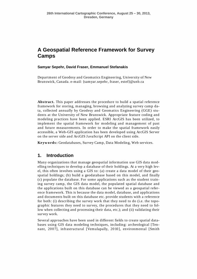
2. Background Each year, GGE students conduct a topographic survey of UNB campus. Students work in groups and each group is assigned a specific area of UNB Campus. Each survey area typically contains several types of features such as buildings, sidewalks, streets, parking lots, elevation data as contours, green areas, trees, lamp posts, etc. Each group is responsible for creating a digital CAD file and a topographic map of their survey area and these two products are typically created using CAD software. Figure 1 shows an ex-ample of survey topographic features for a section of UNB campus.
In general, the student’s survey data tends to accurately depict the location of features on UNB campus – that is, the surveyed data meets camp specifi-cations. However, in examining the student created CAD datasets in GIS software, many issues were identified. Two of these are: (a) no consistent feature coding system; for example, one group may code buildings as BLDG whereas another group may use BL and (b) point and polygon type features were encoded as polylines. Refer to Section 3.1 for more examples of prob-lems with the CAD datasets.
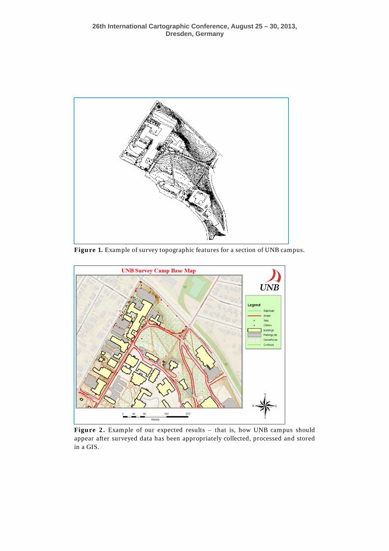
The objective of this project was to create a geospatial reference framework from the student surveyed topographic data. The information products re-sulting from this project are a GIS repository, documentation and a web application. The web application allows students to view the information in the repository. The documentation will describe standards, procedures, quality control mechanisms to ensure their data is suitable for input into the GIS repository of university campus. Figure 2 shows an example of our expected results – that is, how UNB campus should appear after surveyed data has been appropriately collected, processed and stored in a GIS reposi-tory.
26th International Cartographic Conference, August 25 – 30, 2013, Dresden, Germany
Figure 1. Example of survey topographic features for a section of UNB campus.
Figure 2. Example of our expected results – that is, how UNB campus should appear after surveyed data has been appropriately collected, processed and stored in a GIS.
26th International Cartographic Conference, August 25 – 30, 2013, Dresden, Germany
3. Solution and Workflow This section describes the approach that was used to create the geospatial reference framework.
In order to create the framework, we performed the following steps:
1. Created an initial database for UNB campus using existing survey camp data and identified problems with the data.
2. Identified criteria for the survey data to be imported into a spatial database (ArcGIS Geodatabase).
3. Created an ArcGIS Geodatabase for storing UNB campus data. 4. Populated the ArcGIS Geodatabase according to above design.
3.1 Create an initial database and identify inconsistencies in survey data
In this step, we imported the surveyed topographic data (i.e. CAD files) into a GIS. We then examined the data and identified which features types were included surveyed data (not all topographic features on UNB campus were surveyed, e.g. signs) and any inconsistencies in the data. Examples of the inconsistencies in the data are:
• No consistent feature coding system; For example, one group may code buildings as BLDG whereas another group may use BL.
• Point and polygon type features were encoded as polylines. • Different features were often incorrectly coded during the survey
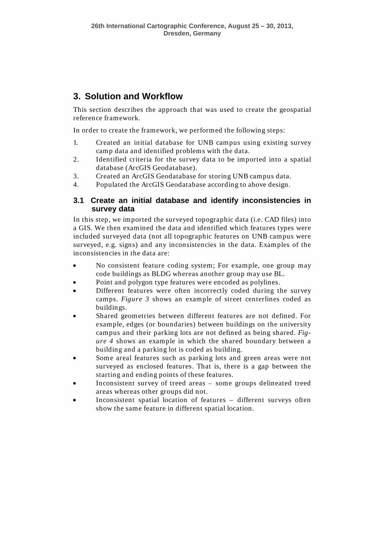
camps. Figure 3 shows an example of street centerlines coded as buildings.
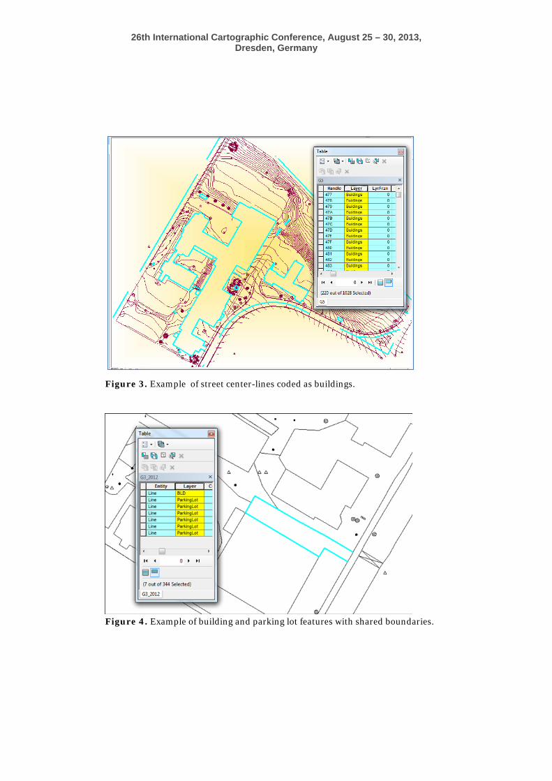
• Shared geometries between different features are not defined. For example, edges (or boundaries) between buildings on the university campus and their parking lots are not defined as being shared. Fig-ure 4 shows an example in which the shared boundary between a building and a parking lot is coded as building.
• Some areal features such as parking lots and green areas were not surveyed as enclosed features. That is, there is a gap between the starting and ending points of these features.
• Inconsistent survey of treed areas – some groups delineated treed areas whereas other groups did not.
• Inconsistent spatial location of features – different surveys often show the same feature in different spatial location.
26th International Cartographic Conference, August 25 – 30, 2013, Dresden, Germany
Figure 3. Example of street center-lines coded as buildings.
Figure 4. Example of building and parking lot features with shared boundaries.

26th International Cartographic Conference, August 25 – 30, 2013, Dresden, Germany
From this step, we made several observations including:
• Manual editing is required to clean surveyed data (e.g. ensure all features are correctly coded) and to correct spatial representation (e.g. represent features such as buildings, parking lots and green areas to represent them as polygons instead of lines. etc.).
• Need standards for students to follow (e.g. common coding scheme for features (buildings – BD, roads – RD), etc.).
• Difficult to determine which student survey data most accurately depicts location of UNB features. Students periodically survey the same area. For example, the engineering building was surveyed in both 2008 and 2010. Unless we actually conduct benchmark sur-veys, it is difficult to determine which dataset (2008 vs 2010) most accurately depicts location of the engineering building.
• Validated our belief that a Geospatial reference framework of the university campus (GIS data repository, web application) would be helpful for future survey camps for several reasons. Two of these are: (a) useful in describing survey work that they need to do and (b) help students validate their results.
• All surveyed data is in New Brunswick double stereographic projec-tion (NAD83 CSRS).
3.2 Identify requirements for the survey data From the above (e.g. features in CAD datasets, inconsistencies in data), sur-vey camp requirements and our knowledge of UNB campus, we identified several requirements for the survey data, including:
• Features to be surveyed is constant and consistent for all areas on university campus –for example, all survey groups will survey treed areas as treed areas as oppose to one group surveying treed area as a treed area and another group surveying treed area as a green space.
• Common coding system will be used to define features – for exam-ple, all buildings coded as BL
• All features will have a consistent spatial representation (e.g. all parking lots will be surveyed as an enclosed feature as oppose to some being surveyed as enclosed feature and others not).
• Shared geometries are indicated in the surveyed data • All features have the same coordinate system.
Note identifying such requirements is a necessary perquisite to database design because they help us to define the characteristics (attributes, shared geometry, etc.) of the input survey camp data.

26th International Cartographic Conference, August 25 – 30, 2013, Dresden, Germany
3.3 Geodatabase Design This section describes the steps that we followed to design a geodatase for student surveyed topographic data. As described in Designing Geodata-bases [Arctur and Zeinel, 2004], there are 10 steps involved in designing a geodatabase. A modified version of these steps is listed in Table 2. As shown in Table 2, these steps can be grouped into 3 phases, namely: (a) conceptual design; (b) logical design and (c) physical design.
Table 2. 10 steps in Designing a Geodatabase [Arctur and Zeinel, 2004] Steps Phase
1. Identify the information products that will be produced by the created framework
2. Identify the key thematic layers 3. Specify the scale range and spatial representati-
on for each thematic layers of the base map 4. Group representations into datasets
Conceptual Design
5. Define the tabular database structure and beha-vior for descriptive attributes
6. Define the spatial properties of your datasets 7. Propose a geodatabase design
Logical Design
8. Implement, prototype, reviews and refine the design
9. Design work flows for building and maintaining each layer
10. Document your design using appropriate me-thods
Physical De-sign
These steps are now briefly described below along with the results of im-plementing a Geodatabase design for this project.
3.3.1. Identify the information products Based on the survey camp requirements and our knowledge of GIS database creation, the following information products were identified: • A GIS repository for UNB Campus which contains survey camp data.
The repository contains best survey camp data in terms of the year of data collection and data completeness.
• A Web-GIS application which shows the information in the GIS reposi-tory.
26th International Cartographic Conference, August 25 – 30, 2013, Dresden, Germany
• Documentation that describes standards, procedures and quality con-trol mechanisms to ensure their data is suitable for input into the GIS repository of university campus.
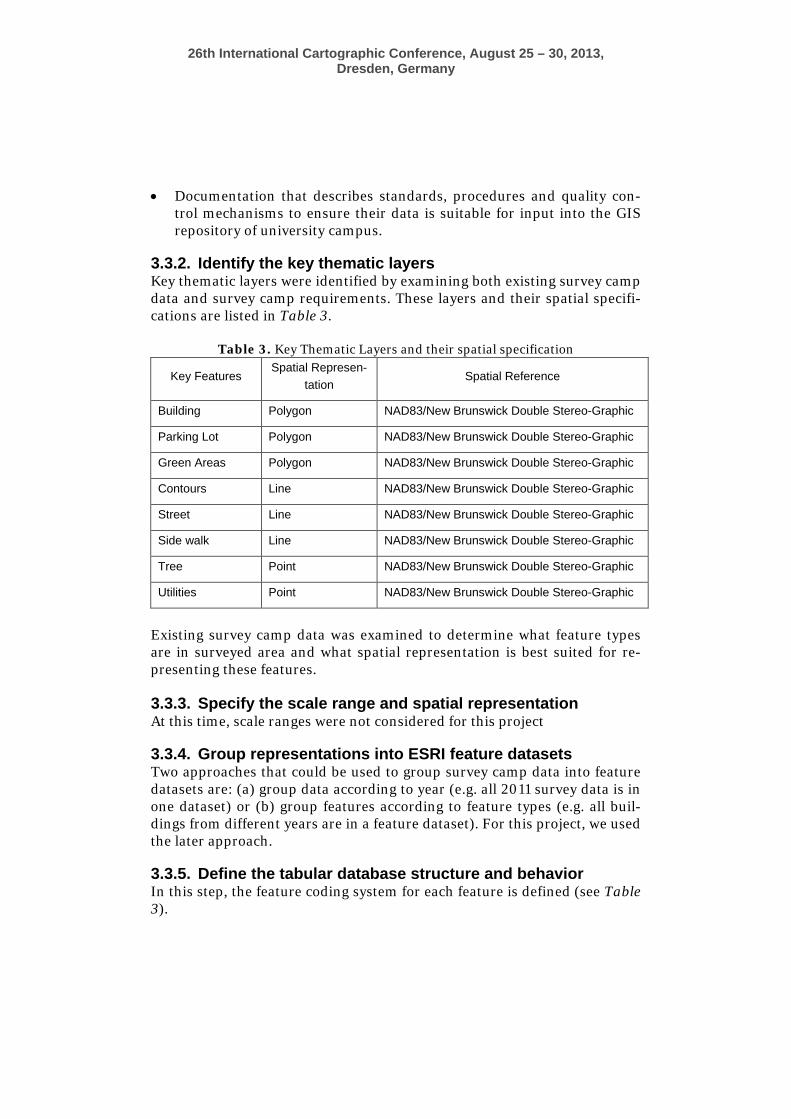
3.3.2. Identify the key thematic layers Key thematic layers were identified by examining both existing survey camp data and survey camp requirements. These layers and their spatial specifi-cations are listed in Table 3.
Table 3. Key Thematic Layers and their spatial specification
Key Features Spatial Represen-
tation Spatial Reference
Building Polygon NAD83/New Brunswick Double Stereo-Graphic
Parking Lot Polygon NAD83/New Brunswick Double Stereo-Graphic
Green Areas Polygon NAD83/New Brunswick Double Stereo-Graphic
Contours Line NAD83/New Brunswick Double Stereo-Graphic
Street Line NAD83/New Brunswick Double Stereo-Graphic
Side walk Line NAD83/New Brunswick Double Stereo-Graphic
Tree Point NAD83/New Brunswick Double Stereo-Graphic
Utilities Point NAD83/New Brunswick Double Stereo-Graphic
Existing survey camp data was examined to determine what feature types are in surveyed area and what spatial representation is best suited for re-presenting these features. 3.3.3. Specify the scale range and spatial representation At this time, scale ranges were not considered for this project
3.3.4. Group representations into ESRI feature datasets Two approaches that could be used to group survey camp data into feature datasets are: (a) group data according to year (e.g. all 2011 survey data is in one dataset) or (b) group features according to feature types (e.g. all buil-dings from different years are in a feature dataset). For this project, we used the later approach.
3.3.5. Define the tabular database structure and behavior In this step, the feature coding system for each feature is defined (see Table 3).

26th International Cartographic Conference, August 25 – 30, 2013, Dresden, Germany
Table3. Attribute system for each identified features in survey camp Feature Classes Feature Code Field Data Type Length
Building BD String 10
Parking Lot PL String 10
Green Areas GA String 10
Contours CT String 10
Street ST String 10
Side walk SW String 10
Tree TR String 10
Utilities UT String 10
At this time, we did not implement any validation rules associated with the individual feature classes (e.g. buildings must be greater that a specific area, trees cannot be inside a building, etc.).
3.3.6. Define the spatial properties of the datasets Since survey camp data is collected in New Brunswick Double Stereogra-phic projection (NAD83 CSRS) projection, this spatial reference system was used for all feature datasets.
3.3.7. Propose a geodatabase design A geodatabase for UNB campus was proposed to several stakeholders associated with his project.
3.3.8 Implement, Prototype Geodatabase Design Final design of the geodatabase consists of feature datasets for each type of campus feature. Depending on spatial representation of a particular feature, the feature dataset may contain either a point, line or polygon feature class. Figure 5 shows the final design and structure of the geodatabase.
Figure 5. Proposed Geodatabase Design

26th International Cartographic Conference, August 25 – 30, 2013, Dresden, Germany
3.3.9 Design work flows for building and maintaining each layer At this time, this step has not been completed. 3.3.10 Document your design using appropriate methods At this time, this step has not been completed. 3.4. Populate the geodatabase We examined student surveys (i.e. CAD datasets) and selected the dataset for each area of UNB campus – recall that UNB campus was divided into survey areas and each group surveyed one area - that appeared to most closely meet survey camp requirements. The fea-tures in these datasets were then added to the appropriate feature class in the geodatabase. These names of these feature classes have the suffix “BaseMap”. Figure 6 shows the populated geodatabase. In the future, we will populate the database with CAD files from pre-vious years. This means for example, that the buildings feature da-taset will also contain feature classes Buildings_2007, Build-ings_2008, etc.
Figure 6. Populated geodatabase.
26th International Cartographic Conference, August 25 – 30, 2013, Dresden, Germany
4. GIS Modeling and Geodatabase Maintenance ArcGIS model-builder and python scripts will be used to: (a) validate future survey camp data; and (b) import this data into the geodatabase. We will validate the survey data to ensure that it conforms to the database model developed above. The validation procedure will consist of ArcGIS models that: (a) perform several checks on the geometry and attributes of the fea-ture classes and (b) report on its results. Such checks will allow us to verify that: (a) all features are assigned a valid code; (b) areal features are en-closed, etc. If the errors/inconsistencies are reported, we may request that survey groups address these problems and resubmit CAD files.
5. Web-GIS Application Development This section describes the development of the Web-GIS prototype for acces-sing and representing the survey camp framework. The prototype system is set up based on ArcGIS server as GIS server and ArcGIS JavaScript API as the web programming language. The web service is built on the UNB cam-pus base map created from survey camp topographic data. The base map is published as an interactive map service. The map service provides a series of functionalities in respect to the framework design and characteristics. GIS functionalities are served by the ArcGIS server and ArcGIS JavaScript API requests the services based on the ArcGIS REST API.
The most important part in developing the prototype system in this project was to design the client side environment. In designing the web application, we have tried to provide appropriate visualizing functionalities along with particular useful query tasks. All these mapping and GIS techniques will help the user to understand and explore the framework through a web ser-vice even without having any specific skills on desktop GIS applications.
In order to develop an interactive web service, a list of base map layers were created. Users can better understand what and which are the main features to be considered during a survey camp operation. Additionally, they can realize the most appropriate symbols and data types for the different fea-tures collected during a survey camp operation. By exploring the layers, the user can also figure out what areas of campus might have lack of data. This is a valuable input for panning the future survey camps.
Figure 7 shows the web service interface. In this snapshot, buildings; par-king lots and streets have been selected as visible map layers. Each of these selected layers has different data type such as polygon or line data types.

26th International Cartographic Conference, August 25 – 30, 2013, Dresden, Germany
Figure 7. Example of selected layers of bas map in web service.
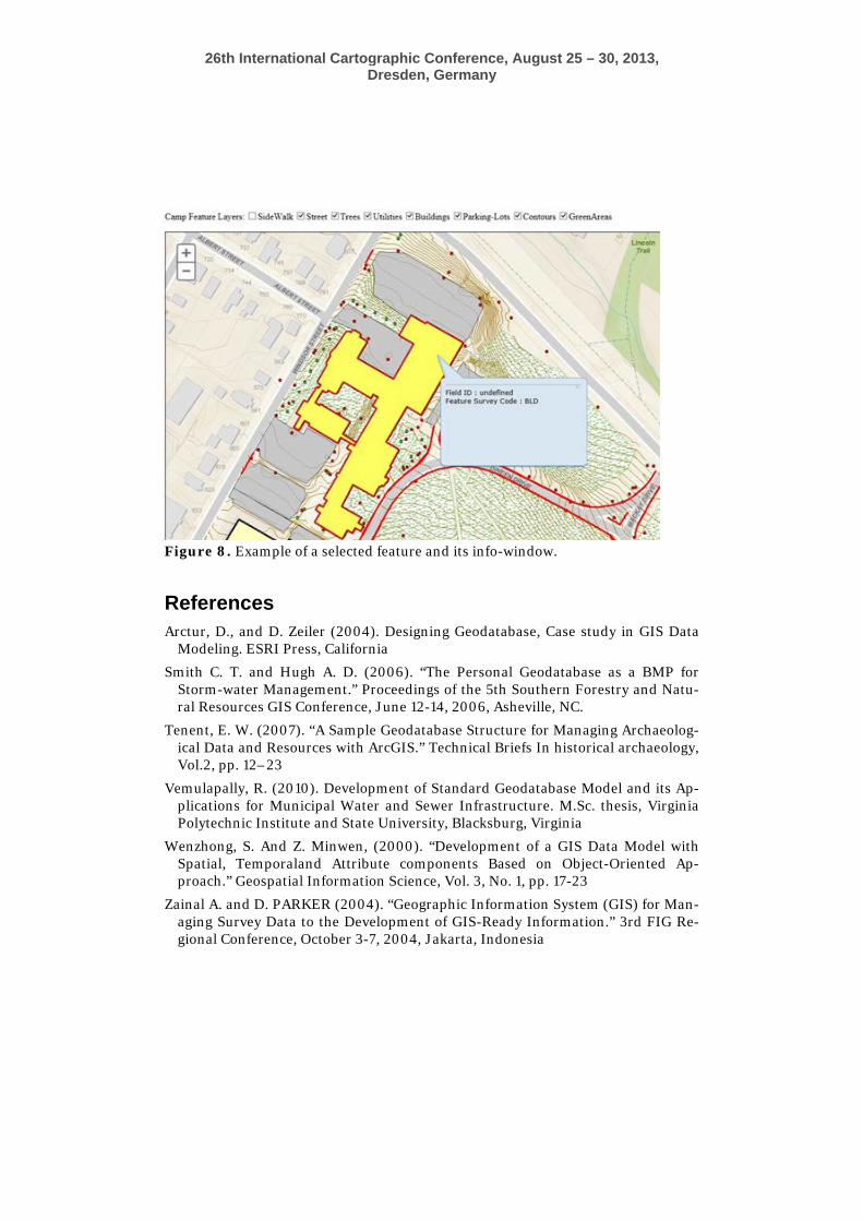
In order to ease the querying process, a service was designed to provide information about features by mouse-clicking on visible layers. A pop-up window appears when user clicks on a feature. This provides information about the identifier and code of the selected feature (Figure 8).
5. Conclusion This paper addresses the procedure to build a spatial reference framework for survey camp data. ESRI ArcGIS has been utilized, to implement the framework, while ArcGIS Server is used to host the corresponding web ser-vices.
The framework and prototype tools built are anticipated to help the stu-dents formalize the way they store, manage, browse and analyze survey camp data. On the other hand, camp organizers will be able to monitor the past and plan the future survey camp missions efficiently.
26th International Cartographic Conference, August 25 – 30, 2013, Dresden, Germany
Figure 8. Example of a selected feature and its info-window.
References Arctur, D., and D. Zeiler (2004). Designing Geodatabase, Case study in GIS Data
Modeling. ESRI Press, California
Smith C. T. and Hugh A. D. (2006). “The Personal Geodatabase as a BMP for Storm-water Management.” Proceedings of the 5th Southern Forestry and Natu-ral Resources GIS Conference, June 12-14, 2006, Asheville, NC.
Tenent, E. W. (2007). “A Sample Geodatabase Structure for Managing Archaeolog-ical Data and Resources with ArcGIS.” Technical Briefs In historical archaeology, Vol.2, pp. 12–23
Vemulapally, R. (2010). Development of Standard Geodatabase Model and its Ap-plications for Municipal Water and Sewer Infrastructure. M.Sc. thesis, Virginia Polytechnic Institute and State University, Blacksburg, Virginia
Wenzhong, S. And Z. Minwen, (2000). “Development of a GIS Data Model with Spatial, Temporaland Attribute components Based on Object-Oriented Ap-proach.” Geospatial Information Science, Vol. 3, No. 1, pp. 17-23
Zainal A. and D. PARKER (2004). “Geographic Information System (GIS) for Man-aging Survey Data to the Development of GIS-Ready Information.” 3rd FIG Re-gional Conference, October 3-7, 2004, Jakarta, Indonesia