A Framework to Evaluate the Impact of Building Legislation ... · A Framework to Evaluate the...
30
A Framework to Evaluate the Impact of Building Legislaon on the Performance of the Built Environment The Case of Kuwait, a Master-Planned City-State Saud R AlKhaled Arizona State University under the direcon of Prof. Christoph Reinhart Sustainability Design Lab Department of Architecture Massachuses Instute of Technology Summer Research Internship June 1, 2015 – August 21, 2015 Kuwait-MIT Center for Natural Resources and the Environment August 21, 2015
Transcript of A Framework to Evaluate the Impact of Building Legislation ... · A Framework to Evaluate the...

A Framework to Evaluate the Impact of Building Legislation on the Performance of the Built Environment
The Case of Kuwait, a Master-Planned City-State
Saud R AlKhaledArizona State University
under the direction ofProf. Christoph ReinhartSustainability Design Lab
Department of ArchitectureMassachusetts Institute of Technology
Summer Research InternshipJune 1, 2015 – August 21, 2015
Kuwait-MIT Center for Natural Resources and the EnvironmentAugust 21, 2015

2
Abstract
1.0 Introduction
1.1 Planning Kuwait
1.2 Building Code Simulation
2.0 The Kuwaiti Building Code and the Neighborhood Unit
2.1 The Building Code
2.2 The Neighborhood Unit
3.0 Building Simulation Method
3.1 Site Selection
3.2 Simplification Process 3.2.1 KBC Parameters 3.2.2 Parcelization Schemes 3.2.3 Building Archetypes and the Urban Arrays 3.2.4 Building Property Template
4.0 Performance Metrics & Findings
4.1 Floor Area Ratio
4.2 Operational Energy
4.3 Accessibility
5.0 Conclusion
6.0 Acknowledgments
7.0 References

3
0.0 Abstract
This research focuses on the impacts of building legislations and regulations, in the form of building codes, on the development and formation of the urban fabric. In particular, it investigates the role of building codes on a place that has an inherent social and cultural structure that manifests itself spatially. Using Kuwait city, a once traditional Islamic city, impacts of ‘international’ standards employed through master planning are explored at the scale of the neighborhood. Kuwait city serves as an ideal case study because of its historic Islamic and Arabic urban pattern that was derived from social, cultural and religious beliefs and customs. These influences resulted in a once cohesive city of a courtyard house typology, with narrow and shaded alleyways structured on longitudinal corridors of diverse land-uses that promote access and connectivity; however, the Minoprio, Spencely, and Macfarlane (MSM) master plan of 1951 eradicated this close-knit urban fabric in favor of “modern” planning ideals which were loosely based on Ebenezer Howard’s Garden City. The 1951 plan called for a tabula rasa and the relocation of homes from the historic city center to the newly formed ‘super-blocks’ and ‘neighborhood units’. Houses were built following strict building codes that govern buildings heights, floor-area-ratio, and plot line setbacks along with other land development regulations. The Kuwait Building Code (KBC), introduced in 1955, is based on western planning ideals that are far removed from the existing social and cultural dynamics of Kuwait City. This study will unfold the code by translating the ruling text virtually into its parametric spatial envelope and proposes a framework to evaluate its impact on the performance of the urban environment. Using umi, an urban modeling design tool, the virtual build-up of the rules will allow for a quantifiable examination to evaluate the efficiency of an urban-form-determining building code by considering multiple performance metrics. By objectively evaluating the role that the KBC plays in determining future urban quality, this study aims to suggest for enough space within the code to allow for a larger influence of environmental and cultural factors to promote a ‘resilient and sustainable’ built environment at the neighborhood level.

4
1.0 Introduction
Concerns and reactions to the products of regulated built environments is not new, in fact it dates back to that of Raymond Unwin’s (1909), Fredrick Law Olmsted’s Jr. (1910), Clarence Perry’s (1920) and Thomas Adams’ (1935). Much of the concerns have been examined qualitatively to analyze and document the impact of physical interventions imposed by urban rules and regulations on spatial relationships at the cost of urban quality. Qualitative methods have been deployed to assay the “less quantifiable impact on the quality of life, ambience, neighborhood, and communal integrity” (Dandekar, 1986, p. 44). Though research has widely expressed how building legislation constitutes a major element in the shaping of the built environment, debates concerning its impacts has not received enough empirical testing of its products to further measure its performance and efficiency. This project aims to research the long established debate and fill this apparent gap in the contemporary literature of regulating urbanism using Kuwait as a case study through a collective strategy. It will first simplify the complexity found in the urban texture of Kuwait using archetypal forms and parcelization1 schemes defined within its four2 successive planning strides and governed by the KBC, as shown later in the paper. It will then deploy a simulation-based analysis using Grasshopper parametric modeling environment and umi, a Rhinoceros-based urban modeling tool, to evaluate floor-area-ratio, operational energy, and walkability (Reinhart, Dogan, Jakubiec, Rakha, & Sang, 2013) to the defined products of the KBC. That is in an effort to better understand, answer and add to the extensive literature questioning how building legislation constitutes a major element in shaping the built environment? What are these regulations and how can these regulations promote contemporary urban challenges? What are the influencing factors that impact the built environment? How design and standards affect “livability” and “sustainability” and what role does it play in determining future urban quality?
This research moves beyond the theoretical to the tangible and aims to serve as a model to better understand the interventions of regulations on urban form and formation and its subsequent impact on the physical quality in a more quantifiable approach. The expected simulation findings will also help demonstrate the products of the KBC to later use the performance simulation as a tool for generating higher level planning guidelines to help make decisions and facilitate decision-making processes. This will ultimately bring a new platform for building regulations to enter the process of urban formation as a positive determining factor.
1 The process of subdividing or platting land into smaller parcels 2 (a) 1951 - Minoprio, Spencely and Macfarlane, (b) 1967 – Municipality Development Plan, (c) 1970 – Colin Buchanan and Partners, (d) 1977 – Shankland Cox and Partnership

5
1.1 Planning Kuwait
“It was a difficult commission. We did not know anything about the Muslim world and the Kuwaitis wanted a city – they wanted a new city, hospitals, schools, housing and good communications … All we could give them … was what we knew” (Gardiner, 1983, p. 33). This was a statement, made thirty years after the 1951 Master Plan commission, by Anthony Minoprio, a partner of the then commissioned firm and the planner himself, illustrates the tensions between what the city needed and what the planners wanted. As the master plan was accepted and implemented it called for the complete destruction of the once organic city made of adobe brick courtyard houses, narrow alleyways, and compact urban from in favor of large superblocks – called Commercial Business Districts (CBD)-, wide boulevards, and houses in the newly established ‘suburbs’. The master plan of Kuwait led to a deficient, fragmented and an automobile dependent urban development. These problems are a direct result of the employment of the building code that followed the physical master plan and has been consistently grown and modified since it was first implemented in 1955. Kuwait also sets a radical case with its building regulations concerned weightily on land-use and negatively intensified with its divorce from context. The current and effective code regulating the urban landscape of Kuwait calls for an alarm to further examine its product’s impact on the physical environment and spatial quality. As we identify contemporary urban challenges, it is important to first understand the impact of the building regulations that produced them.
1.2 Building Code Simulation
By using a simulation-based approach, issues that are caused by the KBC can be further analyzed to offer quantified results that can then be used to better understand the current challenges that plague Kuwait City, and cities of the larger Arabian Gulf context which were planned with respect to the so called “international standards”. Ideally, these results will be developed into an index that will allow for the development of better cities in Kuwait as defined by their livability and sustainability matrix. These indices aim to impact urban form in the Middle East in two-folds: first, it will allow for the testing of codes before implementation, and secondly, and more critically, it will allow for the development of urban codes that are inherent and specific to this region. Such codes would aim to produce urban development that is suitable for the natural and socio-cultural environment, and equally accommodates people, cars and buildings to ultimately secure more positive outcomes.

6
The simulation will test the impacts on a case that has fallen victim to non-native urban regulations in which ‘universal’ standards opposed local values of space and place strongly replacing the supremacy of society and culture. It will also attempt to provide answers to the “what if” by enabling various alternative inputs to determine how things could be rather than merely measuring the performance of the existing situation virtually. This approach is an effective model to better understand how the KBC manifests itself on the ground because of its ability to provide accurate empirical findings based on translated, collected and calculated numeric inputs. The residential regulations within the KBC will be virtually replicated, translating the ruling text into an experiential venue by using umi’s workflow. This section will evolve along with the research, and the findings of this investigation will be instrumental in understanding the impacts of contemporary urban regulations at the scale of a neighborhood and will serve as a base for evaluating code-determined urban environments.
2.0 The Kuwaiti Building Code and the Neighborhood Unit
2.1 The Kuwaiti Building Code
Kuwait sets an appropriate case study to examine a then local urban fabric that was eradicated in favor of a universal idea. It is not only that when the aforementioned imported urban frameworks were put into place originated from a different urban condition, more importantly it was an “imposition of western technology onto an established Arab society” (Jamal, 1973, p. 1453). In fact it was a society that had established a closely packed urban pattern that once retained connectivity, pedestrian orientation, land-use diversity, enclosure, and small blocks and certainly did not require an irresponsible planning approach that neglected such context. As proclaimed by Mahgoub, “the city center, once a place where families lived, shopped, worked and played, was foreordained a commercial district and residents were shifted to Western-style family homes and apartments in the new neighborhood” (2007, p. 72). To maintain this imposition of “Western standards” and remedy the “primitive condition”, MSM also found it “necessary to control the way in which buildings shall be erected, their height, the amount of land which each can occupy, the distance between buildings and the width of development roads giving access to houses” (Minoprio & Spencely and P.W. Macfarlane, 1951, p. 31). This was the first attempt alluding the control of urban development practices in Kuwait, replicating English and non-native standards into the Kuwaiti context. What compounded the problem, Jamal (1973) explains, is the “fact that the work was done in far away London”(p.1,453) and accordingly came the controls of which were a response to difficulties in a different context. The report of

7
the 1951 Master Plan had not set the governing urban codes, at that stage MSM saw it necessary to “only call attention to the need for such rules; their preparation will require detailed study of local conditions”(p.31). Apparently, the advice was favorably considered and with the establishment of the Building and Permissions Affairs within the Technical Department at Kuwait Municipality in 1954, followed a mature document titled Nitham AlBina’ 1955 (The Building Code 1955). The code that developed from a recommendation in several sentences within the 1951 Master Plan report grew into a forty-one-page document of eight broad sections: Section 1: General Provisions Relating to Permits 1.1 Ban of building without permit 1.2 Permitting terms 1.3 Issuing a permit Section 2: General building regulations and height conditions Section 3: Floor Heights; Protrusions; Enclosed/Exposed Balconies; Staircases Section 4: Enclosure of construction sites and public properties Section 5: Particular regulations to the different urban areas and building types 5.1 Individual palaces 5.2 New Residential Areas 5.3 Older neighborhood areas – residences inside the city wall 5.4 Light industries area 5.5 heavy industries area Section 6: Sanitary Regulations (plumbing and drainage) Section 7: Miscellaneous Provisions Section 8: Final Provisions
The enactment of the 1955 building code was evident in the report of Saba Shiber (the Architectural and City Planning Advisor to the government in the 1960’s) addressed to the Municipal Council in 1961. It states:
The draft for a new building code has been prepared for the city of Kuwait that incorporates many sound principles of building practice. It is expected that, soon, the Municipal Council will enact this essential piece of legislation into law. Regulations governing coverage of land, heights, and setbacks in residential areas have already been enacted into law. (p.17)
As Shiber indicates, several sets of building regulations then followed that of 1955’s. A set of building regulation was issued in 1961 and within three years - in his documentation

8
of his experience in Kuwait’s urbanization process (1964) - Shiber mourns the separation of “indigenous and local characteristics and problems” from “the overall picture”. The absence of culture and place came apparent to the urban environment as a product to rapid imported transformation. He further explains with distress:
There is Kuwait’s climate and local building materials; there is the existing and particular urban fabric and social structure; there is the particular and unique economy and the demographic dynamics; there are the cultural-ethnic characteristics and the landscape features that must enter the picture in the synthesis and evolution of a housing program, in building it, managing it, and making it a human environment instead of merely a dormitory assemblage of monotonous and soulless buildings. (p.228)
The 1961 Building code was later followed with another issuance in 1979, and later in 1985 of which largely included all the provisions and rules that are still in affect. The 1985 building regulation controlled development practices of all the allowable building types and densities of land use. Through different modifications since 1985, the document quadrupled in size with its sections almost doubled and renamed as “Schedules”. The 2008 latest amendment contained:
Schedule 1 Conditions and Specifications of Typical Units and Private Residences Under the Municipal Council Decision No. 2008/5/71/7, Dated 7/4/2008
1st Typical Units and Private Residences Article 1: Floor Area Ratio “FAR” Article 2: Building Setbacks and Adjoining Article 3: Building Heights Article 4: Distribution of Areas Article 5: Stairways Article 6: Projections Article 7: Shafts Article 8: Shades/Pergolas Article 9: Annexes Separate from Main Building Article 10: Basement Article 11: Building Services 2nd Private Residential Houses Adjacent on the Same Plot 3rd Diplomatic Area – West Mushrif 4th Multipurpose Halls
Schedule 2* Conditions and Specifications of Investment Residential
* Schedule specific articles were not included for the purpose of this study

9
Buildings (outside and inside Kuwait City) under the Municipal Council Decision No. 2008/7/172/, Dated 5/5/2008
Schedule 3* Conditions and Specifications of Commercial Buildings (outside and inside Kuwait City) under the Municipal Decision No. / /2008, Dated / /2008
Schedule 4* Conditions and Specifications of Buildings in the Industrial Areas under the Municipal Council Decision No. 2008/5/74/6, Dated 7/4/2008
Schedule 5* Conditions and Specifications of Residential Complexes (outside and inside Kuwait City) under the Municipal Council Decision No. 2008/7/172, Dated 5/5/2008
Schedule 6* Conditions and Specifications of Commercial Complexes (outside and inside Kuwait City) under the Municipal Council Decision No. 2008/7/172, Dated 5/5/2008
Schedule 7* Conditions and Specifications of Buildings at the Coastal Strip Area under the Municipal Council Decision No. 2008/5/77/6, Dated 7/4/2008
Schedule 8* Conditions and Specifications of the Green Houses in all Areas of Kuwait under the Municipal Council Decision No. 2008/7/172/, Dated 5/5/2008
Schedule 9* Conditions and Specifications of Chalet Buildings in all Areas of Kuwait under the Municipal Council Decision No. 2008/7/172/, Dated 5/5/2008
Schedule 10* Conditions and Specifications of Private Hospital Buildings in all Areas of Kuwait under the Municipal Council Decision No. 2008/7/172/, Dated 5/5/2008
Schedule 11* Conditions and Specifications of Private School Buildings in all Areas of Kuwait under the Municipal Council Decision No. 2008/10/242/, Dated 23/6/2008
Schedule 12* Conditions and Specifications of Hotel and Motel Buildings in all Areas of Kuwait under the Municipal Council Decision No. 2008/7/172/, Dated 5/5/2008
* Schedule specific articles were not included for the purpose of this study

10
Schedule 13* Conditions and Specifications of Agricultural and Animal Raising Areas under the Municipal Council Decision No. 2008/7/172/, Dated 5/5/2008
Schedule 14* Conditions and Specifications of Non-Profit Organization Buildings at Jleeb AlShuyoukh under the Municipal Council Decision No. 2008/7/172/, Dated 5/5/2008
Since its issuance, the Building Code went through several modifications of which Mahgoub (2002) have surveyed to find its development trends and unfavorable impacts. The study examined the incessant changes of the regulations and its impacts on the single-family residential neighborhood level. Mahgoub, using observation analysis as a tool, specifically observed the impacts of changed setback and area regulation on the configuration of the built environment. These included hostile streetscape, invasion of privacy, lack of character, loss of green-space, reduction of suppressed social interaction, historical discontinuity and visual pollution. Undoubtedly building regulations constitute as a major contributing factor in determining the urban environment. Kuwait sets this radical case with the building regulations concerned weightily on land-use and negatively intensified with its divorce from context. The current and effective code regulating the urban landscape of Kuwait calls for an alarm to further examine its product’s impact on the physical environment and urban quality. 2.2 The Neighborhood Unit
The arrival of the Neighborhood Unit3 was evident in the MSM Master Plan of 1951 and the rapid transition of urban form through comprehensive planning, which as a result became an institutionalized approach. The first master plan - commissioned to MSM in 1951 and implemented that same year –, as Abdo states, “left a permanent impact on the State’s physical development” with elements of which he summarized as:
a. As reference points, the Development consisted of radial roads converging on and providing access to the old town as extended through its wall gates, and concentric roads running parallel to the line of the town wall, with the first of several ring roads forming along the southern limits (wall) of the town.b. The resulting pattern outside the town was the formation of over twenty ‘super-blocks’, surrounded by the road network. These blocks were for the most part residential neighborhoods measuring about two
* Schedule specific articles were not included for the purpose of this study3A concept developed by Clarence Perry (1929) defining the physical arrangement of neighborhoods and each to be a ‘unit’ within the city. For further information refer to The Neighborhood Unit (1929).

11
sq.km (Figure 1), with each containing its own social and civic facilities such as super-market cooperative, shops, clinic, mosque, post office in a central area, in addition to a number of schools located in more than one location. The remainder of the super blocks were designated for industrial, education and health uses.c. The semicircular line representing the old town wall (of which only the gates were to be left standing) with a width of about 250 meters, was reserved as a recreational strip which came to be known as the ‘Green Belt’.d. As for the old town itself, the plan basically provided for the widening of its main roads rather than creating a different circulation pattern, with zoning for various types of land use.e. The old town was targeted for large-scale re-development as the focal point of business and government for the expanded city – ‘Greater Kuwait’ – with only limited use as a residential area. (Abdo, 1988, p. 115)
Centered
Reared
Central Void
Edge Void
Scheme1.0 Scheme2.0
ArchetTYPES
1530.00m
1170.00m
3
3 3 3 3 3 3
4 4 4 4 4 44 4 4 4 4 4
33
444
444
444
444
444
444
Scheme2.0
22
2 2 22 2 22
111
22
22
22
22
22
22
Scheme1.0
Simplification & Parcelization Schemes
2012
1952
1952
1970
1970
1967
1967
2005
2005
Figure 1. Top Left. Old walled town of Kuwait (Pre-Oil Era) Top Right. Kuwait’s first Master Plan, commissioned to MSM, with the concept of dramatically extending the city beyond its walls in a radial structure with the use of the ring roads Bottom Left. Highlighted in red is the pattern resulting outside of the town (the neighborhood units) in a nonnative central structure as opposed to the local linear structure.
Illustration by author based on:Kuwait Oil Company (1951)Minoprio & Spencely and P.W. Macfarlane (1951)

12
The resulting pattern outside the town is the focus of this investigation and especially the copied neighborhoods or the ‘super-blocks’. As above-mentioned and methodically explained by Abdo, the radial roads and the ring roads extending outside the town influenced the future pattern of urbanization and by and large shaped the approaching eight “neighborhood-units”. Shiber (1964) claims that Kuwait was the first Arab city that has adopted the neighborhood-unit concept in its comprehensive planning.
The neighborhood-unit concept was developed and clearly articulated by Clarence Perry in the 1920s in the United States (Levy, 2013; Patricios, 2002). The basis idea underlying the neighborhood unit concept is to encompass: “(1) a limited population; (2) the essential supporting neighborhood facilities and the amenities for this population such as shopping facilities, kindergarten and primary schools, a clinic and a place of worship; (3) traffic separation; (4) adequate park, recreation and sports facilities; (5) around five to six neighborhood units constituting a ‘community’ with community facilities and amenities such as high schools, auditoria, adequate shopping and recreation facilities and so on“ (Shiber, 1964, p. 219). In the case of Kuwait, and within three years of the master plan, Macfarlane explains the “neighborhood units” in the Journal of the Town Planning Institute as the following:
Outside the wall, the land planned for development will accommodate some 48,000 persons and covers an area greater than the old town inside the wall. Almost flat and all sand, it is being divided by main roads into eight communities of approximately 6,000 persons. Each will have its mosque, public hall, shops, site for service industry and separate primary schools for boys and girls with ample room for play and games, as well as six nursery schools. Every four neighborhoods will be served by two secondary schools. Several schools are under construction and the first neighborhood area is at present being laid out. Within the neighborhoods, internal development roads are laid out roughly on an east-west line and each serves normally about 160 houses grouped round a nursery school. House plots, varying in size from 500 sq. meters to 1,000 sq. meters, and 50% built over. (Macfarlane, 1954, p. 113)
Although Perry’s development of the neighborhood unit came as a product resulting form dissatisfaction with zoning – 30 years prior to the MSM master plan of Kuwait – however and absurdly it was yet still incorporated and ingrained in the practice of Minoprio & Spencely and P.W. Macfarlane’s town planning. Paradoxically, as Talen (2009) puts it, “Clarence Perry lambasted zoning as inflexible and not able to invest a

13
residential district with ‘attractiveness’” (p.155), yet his product developed to be fused as a zoning function at the outset of planning Kuwait. In an analytical critique to this imposition and forced non-native concepts, Sabbar (1971) explains how MSM’s neighborhood arrangement is incompatible to Kuwait’s social and cultural context. He explains that the neighborhood centers in their Western style of occupying physical central sites are highly challenged with local social norms. Sabbar argues that the “European notion of sitting centers and services in the middle of a green open space, and the wife walking her child to school and then strolling to the supermarket for her shopping needs, is not the norm in Kuwait” (Abdo, 1988, p. 72). He suggests that a better configuration would be to arrange the house plots with the neighborhood amenities along a longitudinal corridor as it was traditionally. The principles of the traditional setting allows for qualities that promote cohesiveness in honest urban forms as it responds to local requirements. Shiber explains his dissatisfaction resulting from the discordance and disharmony of the city due to the applied and unsuitable western developed concepts as he states:
Contrasting with the simple, humble, dignified, beautiful and organic architecture that is the heritage of the Old Kuwait is the complicated, gaudy, undisciplined, ill-mannered and inorganic architecture that has in “one fell swoop,” replaced or bulldozed away the tranquil and indigenous architecture deriving from the Kuwait habitat […] Any discussion of housing is incomplete without reference to the absence, so far, of a balanced, harmonious and varied admixture of different known types of housing. Strange physical-architectural phenomena characterize the present residential areas of Kuwait. The neighborhood units contain, one hundred percent, the single-house type of residential areas of Kuwait. The remaining areas, particularly those in the Hawalli-Nugra-Salmyya residential areas, contain the multifamily type dwelling going up in height sometimes to four stories. This dichotomous segregation of housing type may have had some strong justifications in the past. However, it would seem inadvisable to continue designing neighborhood-units on the basis of only the single house type at the expense of the exclusion of all the other types, as well as allowing buildings to create radical dichotomies in overall residential zoning or distribution. (Shiber, 1964, pp. 287, 231)
The many scholarly questioning and critique to the replacement of the rational old by

14
the irrational new urbanization principles, environments and architecture of the post oil era in Kuwait are still valid and applicable to the contemporary situation. Development practices are still considered ill-suited to climate and to the remaining traditions, which calls for a need to guide and govern practices to develop truthful domestic urbanism and further enhance the urban quality.
3.0 Building Simulation Method
3.1 Site SelectionTo empirically test and evaluate the current impacts of building regulations on the performance of urban form, a residential area was selected. That is mainly because the major part of Kuwait’s urban area is devoted to dwelling units whom by and large fall in two distinct types of dwellings; single family (low density) or multifamily (high density) units. The Central Statistical Bureau of Kuwait has conducted a Building and Dwelling Census (2011) displaying the number of buildings by type in each governorate as shown in Table 1. It can be clearly depicted that single dwelling units dominate the current physical fabric of Kuwait accounting for 71%, the highest of all building type categories.
Building Type Al-‐Asimah Hawalli Al-‐Ahmadi Al-‐Jahra Al-‐Farwaniya Mubarak Al-‐Kabeer All Governorates
Apartment (Multifamily) 907 6,945 2,580 518 3,933 382 15,265 Villa (Single Detached) 16,958 20,392 21,384 12,334 18,306 18,029 107,403 Palace (Single Detached) 46 35 10 6 3 11 111 Vernacular Dwelling 2,310 271 2,485 12,186 4,590 552 22,394 Chalet 221 10 2,097 170 30 16 2,544 Other Vernacular Buildings 788 121 2,927 6,331 2,651 117 12,935 Shanty 174 60 103 375 79 45 836 Other Auxiliary Buildings 331 409 544 2,108 604 101 4,097 Hotel and Apartments Hotel 45 69 36 31 33 9 223 Retail Complex 1,137 253 275 291 571 217 2,744 School 136 201 195 148 173 95 948 Hospital 36 25 24 12 17 11 125 Clinic 23 11 14 17 22 8 95 Police Station 14 9 12 17 11 6 69 Grocery Store 120 114 133 148 120 70 705 Mosque 238 176 284 219 249 116 1,282 Religious Building 6 4 7 7 5 1 30 Restaurant 129 69 33 38 40 17 326 Sports Club 39 26 23 13 13 12 126 Governmental Building 431 277 399 372 214 110 1,803 College 19 11 7 -‐ 10 1 48 Institute 23 29 9 1 6 4 72 Sports Complex 10 17 4 5 5 3 44 Embassy 53 42 2 -‐ -‐ -‐ 97 Banks and Branches 61 29 33 15 37 17 192 Factory 28 7 214 380 84 316 1,029 Under construction 2,142 733 915 1,952 1,121 275 7,138
Total 26,425 30,345 34,749 37,694 32,927 20,541 182,681
Table 1. Building and Dwelling Census (2011) conducted by The Central Statistical Bureau of Kuwait

15
AlYarmouk, the selected residential area, is a ‘super block’ planned within the third master plan of Kuwait by Colin Buchanan and Partners (1970) and executed during a 10-year period [Figure 2]. According to Collin Buchanan and Partners, during the planning of AlYarmouk and the latter neighborhoods the “original ‘super-block’ system of development was extended” (1970, p. 4). The distribution and platting of the neighborhoods were planned “broadly on the lines of the first neighborhoods (Dasma, Shaab, Kaifan, Faiha) namely at low density, with wide internal roads and generous incidental open space, with a centrally-located neighborhood center … and a number of ‘local centers’ – (approximately one every 300 plots)” (Collin Buchanan and Partners, 1970, p. 32). Typically, the distribution of land uses within the planned residential areas include the dwellings units, a central cooperative supermarket and retail plaza, a health clinic, police station, public school, mosque, playing field, roads and parking. AlYarmouk inhabits 1,336 parcels that range from an approximate area of 375 to 1,000 square meters organized in 4 blocks of approximately 334 units each and the central block for public services and supporting amenities. Figure 3 shows the geometric structure of Block 1 that generally represents larger context of the applied ‘neighborhood unit’ concept and is considered an appropriate sample to this investigation.
Figure 2. Highlighted is AlYarmouk a superblock planned within the third stride (1970). The accretion planning strategy is clearly presented by the temporal boundary lines of urbanization extensions respectively.
Illustration by author based on Alshalfan (2013).
2012
1952
1970
1967
2005

16
3.2 Simplification Process To perform such an investigation the process of classification and simplification of the existing urban environment complexity becomes essential. Such a process was pioneered by March and Martin (1972) which simplified urban arrays on archetype basis were analyzed influencing numerous urban inquiry approaches. While looking at the impacts of urban governance, defined for the purpose of this research as the Kuwaiti Building Code, the method begins with (a) the translation of the ruling text into its numeric-spatial parameters, (b) the development of parcelization schemes (simplification), (c) the classification of building archetypes, and (d) the definition of building properties into templates. A process further explained in the following sections.
3.2.1 KBC ParametersAs mentioned earlier in section 2.1 of this report, the relevant section to be examined within the Kuwaiti Building Code is “Schedule1. Conditions and Specifications of Typical Units and Private Residences” (Municipal Council Decision No. 2008/5/71/7, Dated 7/4/2008). From the previously listed eleven articles of Schedule 1, three sections
Figure 3. AlYarmouk’s ‘superblock’ structure organized into four neighborhood units, each with a central services area. Highlighted is the selected Block1.

17
are associated to the spatial parameters of urban forms produced by the KBC. Those of which are the allowable Floor Area Ratio (FAR), the minimum Building Setback (side and front) and working in concert to influence building form is the maximum Building Height. While the rest of the eight articles influence the products of urban form, the former significantly outweighs. Listed in Table 2 are the allowable urban form parameters as regulated within the KBC and later used in the development of the Building Archetypes (further explained in section 3.2.3).
3.2.2 Parcelization Schemes Determining the size of parcels in planning Kuwait’s residential urban areas was strongly influenced by the first master plan of Macfarlane, et al., in 1951. In the development of the third master plan, Buchanan proclaims the process of using the then existing (1970) density figures from five single dwelling residential areas (Mansouriyah, Idailiya East, Shamiyah, Qadisiyah and Khalidiya) as a guide (Collin Buchanan and Partners, 1970). This resulted in an accretion-planning strategy of neighborhoods with a combination of 750 and 1,000 square meter parcels, as is the case of AlYarmouk and the rest of the planned neighborhood units. Such in influence, which still predominates current practices, is the governing principal of the simplification process deployed in this study. The development of the parcelization schemes came in two folds; the generic parcel dimensions and the neighborhood configuration. To incorporate the largest possible parcel types in this investigation four generic parcel dimensions were considered (Figure 4).
Figure 4. Four generic parceltypes (PT): (PT1) 1000 sqm, (PT2) 750 sqm, (PT3) 500 sqm and (PT4) 375 sqm
Table 2. KBC allowable building form spatial parameters (* building on front parcel boundary line is allowed for the ground floor only with a maximum of 50% linear frontage)
Front* (m) Side (m)250-‐349 800 sqm 2 1.5350-‐400 210% + 120 sqm 2 1.5401 -‐749 210% 2 1.5750-‐ 210% 3 2
� 15 (max building height)
SetbackFAR Height (m)Parcel Area (sqm)
� 3 (min floor to floor)
25.00m
I
25.00m
IV
25.00m
40.0
0m
20.0
0m
III25.00m
30.0
0m
15.0
0m
II

18
The selected neighborhood unit, Block 1, was then simplified by regularizing its physical form while maintaining its spatial extents (Figure 5). Reverse platting was later performed where adjacent parcels were consolidated outlining a periphery line to allow the ordering of PT1 and PT2 in a scheme and PT3 and PT4 in another. This resulted in two distinct parcelization schemes, one including the original 1,000 (PT1) and 750 (PT2) square meter parcels and the other being a second generation of attempted densification using 500 (PT3) and 375 (PT4) square meter parcels – a practice of dividing the original parcel types to increase density. Both schemes have the parcels arranged within the peripheral limits derived from the reverse platting process of the original block (Figure 5).
Figure 5. Top. AlYarmouk Block 1 simplification process Bottom. The resulting two parcelization schemes and the configuration of the four parcel types. Parcel Scheme 1 includes is a combination of PT1 and PT2, where Parcel Scheme 2 includes PT2 and PT3.
a. AlYarmouk, Block 1
d. Parcel Scheme 1 PT1 (1000sqm)
PT2 (750sqm)
e. Parcel Scheme 2
c. Parcel consolidation b. Simplification process
PT3 (500sqm)
PT4 (375sqm)
a. AlYarmouk, Block 1
d. Parcel Scheme 1 PT1 (1000sqm)
PT2 (750sqm)
e. Parcel Scheme 2
c. Parcel consolidation b. Simplification process
PT3 (500sqm)
PT4 (375sqm)

19
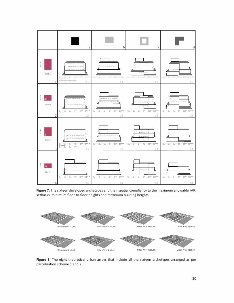
3.2.3 Building Archetypes and the Urban ArraysTo represent the range of present built forms within the residential context of Kuwait, four distinct building typologies were classified. Figure 6 illustrates the generic typologies in the context of filled against void volumes within any of the four parcel-types. The four building typology classifications are: centered to the plot boundaries, reared form the parcels frontage, encloses a central-void and lastly the edge-voided.
Figure 6. Four generic building typologies the Centered, Reared, Central-Void, and Edge-Void
Assigning each of the typologies to the four parcel types and conforming there massing to the allowable parameters of the KBC developed sixteen discrete archetypes. This approach is to be considered a simplified representation of the existing urban forms produced as a result of the KBC. All of the archetypes are within 100% compliancy to KBC Schedule 1 (see Section 2.1 and 3.2.1), window-to-wall ratios were applied uniformly and determinant to orientation, and other non-geometric properties were equivalently assigned to all archetypes as discussed further in Section 3.2.4. This is in an effort to keep all spatial and non-spatial building properties analogous and restrict the distinction to only the physical layout of the archetypes. The investigated sixteen archetypes are illustrated in Figure 7 and vary horizontally by generic typology and vertically by parcel type.
Using the simplified site layout of AlYarmouk Block 1 (Parcelization Schemes 1 and 2), eight theoretical urban arrays were developed by extrapolating the archetypes to their corresponding parcels (Figure 8).
20
25.00m
15.0
0m
IV
25.00m
I
40.0
0m
25.00m
20.0
0m
III
25.00m
30.0
0m
II
1
2
3
4
a b c d
a1 b1 c1 d1
a2 b2 c2 d2
a3 b3 c3 d3
a4 b4 c4 d4
GF FF SF Roof* Total BUA Remaining FAR 735 735 735 -105 2100 0.00FAR COMPLIANTGF FF SF Roof*700 700 700 0
GF FF SF Roof* Total BUA Remaining FAR 666.67 518 518 50 1752.67 347.33
GF FF SF Roof* Total BUA Remaining FAR 837.5 593 593 50 2073.5 26.50
GF FF SF Roof* Total BUA Remaining FAR 833.33 605.5 605.5 50 2094.33 5.67
GF FF SF Roof* Total BUA Remaining FAR 525 525 525 0 1575 0.00
GF FF SF Roof* Total BUA Remaining FAR 500 378 378 50 1306 269.00
GF FF SF Roof* Total BUA Remaining FAR 603.12 409.25 409.25 50 1471.62 103.38
GF FF SF Roof* Total BUA Remaining FAR 625 443.62 443.62 50 1562.24 12.76
GF FF SF Roof* Total BUA Remaining FAR 363 363 363 -39 1050 0.00FAR COMPLIANTGF FF SF Roof*350 350 350 0
GF FF SF Roof* Total BUA Remaining FAR 333.3 260.33 260.33 50 903.96 146.04
GF FF SF Roof* Total BUA Remaining FAR 418.75 302 302 27.25 1050 0.00
GF FF SF Roof* Total BUA Remaining FAR 416.67 306.17 306.17 20.99 1050 0.00
GF FF SF Roof* Total BUA Remaining FAR 253 253 253 50 809 98.50
GF FF SF Roof* Total BUA Remaining FAR 250 187 187 50 674 233.50
GF FF SF Roof* Total BUA Remaining FAR 300 203 203 50 756 151.50
GF FF SF Roof* Total BUA Remaining FAR 312.5 220 220 50 802.5 105.00
Urban Array 1 (a1,a2) Urban Array 2 (a3,a4)
Urban Array 3 (b1,b2) Urban Array 4 (b3,b4)
Urban Array 5 (c1,c2) Urban Array 6 (c3,c4)
Urban Array 7 (d1,d2) Urban Array 8 (d3,d4)
Urban Array 1 (a1,a2) Urban Array 2 (a3,a4)
Urban Array 3 (b1,b2) Urban Array 4 (b3,b4)
Urban Array 5 (c1,c2) Urban Array 6 (c3,c4)
Urban Array 7 (d1,d2) Urban Array 8 (d3,d4)
Urban Array 1 (a1,a2) Urban Array 2 (a3,a4)
Urban Array 3 (b1,b2) Urban Array 4 (b3,b4)
Urban Array 5 (c1,c2) Urban Array 6 (c3,c4)
Urban Array 7 (d1,d2) Urban Array 8 (d3,d4)
Urban Array 1 (a1,a2) Urban Array 2 (a3,a4)
Urban Array 3 (b1,b2) Urban Array 4 (b3,b4)
Urban Array 5 (c1,c2) Urban Array 6 (c3,c4)
Urban Array 7 (d1,d2) Urban Array 8 (d3,d4)
Figure 7. The sixteen developed archetypes and their spatial compliancy to the maximum allowable FAR, setbacks, minimum floor-to-floor heights and maximum building heights.
Figure 8. The eight theoretical urban arrays that include all the sixteen archetypes arranged as per parcelization scheme 1 and 2.

21
3.2.4 Building Property TemplateTranslating building properties into templates (BPT) is a process of inputting non-geometric data into the Template Library Editor (an independent application provided with UMI). The data is necessary to execute building performance simulation and mainly include thermal loads (occupancy, equipment, lighting and infiltration), construction assembly properties and conditioning systems (set points, rates and CoP of the systems). Such data was mainly retrieved from available documentation found in energy and construction regulatory codes, published research (Al-Mumin, Khattab, & Sridgar, 2003) and local expertise. It was also assumed that all buildings are to be newly constructed and conforming with the latest modification of the Ministry of Energy and Water’s Energy Conservation Code (MEW, 2014). That said and as mentioned earlier, one BPT was developed and assigned to all the archetypes to restrict any dissimilarity to only their physical and spatial properties.
4.0 Performance Metrics & FindingsThe deployed plug-in tool for the Rhinoceros3d CAD modeler, UMI, allows for modeling the environmental performance of neighborhoods with respect to operational energy, embodied energy (lifecycle impact) and design accessibility. The performance metrics selected for the purpose of this research are land-use efficiency by measuring urban density of the eight theoretical urban arrays, operational energy of each of the sixteen archetypes within the theoretical neighborhood configurations, and the evaluation of accessibility of the two parcelization schemes developed.
4.1 FARUrban density is a highly argued term in the discourse of urbanism to define and relate its resulting urban forms with urban quality and performance. Measures of urban density has “evolved form being a result of circumstances to a practically applied, normative concept in city development” (Pont & Haupt, 2010, p. 18) and is considered as a very relatively conceived urban metric. Albeit this confusion, an FAR calculation, or Floor Area Ratio is measured to realize the land utilization of the eight different urban arrays without any reflection to their spatial properties. That is to empirically assess current practices with the intentions of densification through the division of parcel types 1 and 2 to all of the four generic typologies. The resulting FAR metrics have been mapped into Table 3. Supporting the debate on density as a metric, the findings illustrate how Parcelization Scheme 2 regardless of the building typology paradoxically seems to have the lowest FAR. This means that the densification intentions are flawed when considering land-use efficiency, another measure that should come in tandem

22
with the rational of densification. Although this requires further investigation, at this point such findings could be directly correlated to the KBC parameters when applying the setback requirements and the allowable FAR to the second-generation parceltypes, namely PT3 and PT4.
Archetype Urban Array Parceltype BUA/Building Building Count Total BUA FAR1 2100 92 1932002 1575 255 401625
594,825
3 1050 256 2688004 809 314 254026
522,826 1 2094.33 92 192678.362 1562.24 255 398371.2
591,050
3 1050 256 2688004 802.5 314 251985
520,785 1 2073.5 92 1907622 1471.62 255 375263.1
566,025
3 1050 256 2688004 756 314 237384
506,184 1 1752.67 92 161245.642 1306 255 333030
494,276
3 903.96 256 231413.764 674 314 211636
443,050 REARED
30.99
UA Total BUA
40.88
UA Total BUA
CENTRAL VOID
51.13
UA Total BUA
61.01
UA Total BUA
EDGE VOID
71.18
UA Total BUA
81.04
UA Total BUA
CENTERED
11.19
UA Total BUA
21.04
UA Total BUA
Table 3. Floor Area Ratio of the developed building typologies on of the eight urban arrays (UA) based on the four generic archetypes and the two parcelization schemes
4.2 Operational EnergyVery much related to the sense of enclosure is the direct relation of building heights and street-width ratios to controlling solar gains and access to daylight. In the evaluation of built form towards operational energy in a cooling dominated climate such as Kuwait, these two central measures compete. Access to daylight is directly proportional to solar gains of which the latter is ideally not favored in this case. Street width strongly determines the amount of direct radiation received on lower floors of the buildings with respect to the impact of orientation on the time of the day radiation is received. The different archetypes and their configurations within the eight theoretical urban arrays are evaluated in terms of their operational energy. A section of the parcelization scheme that best represents the neighborhood unit was chosen for the simulation as illustrated in Figure 9 to best represent each urban array by including the two parceltypes respectively. This selection will allow a simulation performed on all the four resulting archetypes of each typology.

23
4 4 4 4 44 4 4 4
44 4
444
444
444
444
444
444
3
3 3 3 3 3 3
33
11122
2 2 222
2
2
2 2
2
2
2
2
2
2
2
2
2
2
Parcel Scheme 1 Parcel Scheme 2
Figure 10 shows the simulated yearly operational energy performance for each of the selected parcels to the four typologies. The simulation overlooks the aspect of spatial quality by assuming that less daylight will cause less solar gain and hence a better performing archetype. It is also not considering passive systems and only accounting for active systems representing the universal dependence on air conditioning systems, artificial lighting, and electrical appliances among households in Kuwait (Jaffar, Oreszczyn, & Raslan, 2014). A fixed occupancy density assumption was set to all archetypes as well, through the building property template. As presented in Figure 10, the centered typology archetypes outperforms the rest, supporting the long-standing suggestion of researches of applying deep-form building typologies in hot-arid climates (Olgyay & Olgyay, 1963). The least performing typology would be the central-void, which also arises the debate in energy efficiency and thermal comfort of central courtyard buildings. It can be also depicted that larger parceltypes outperform the smaller as illustrated from left to right that also supports the employment of deeper urban forms in hot-arid climates. The average annual electrical consumption of each building parceltype with the four archetypes is illustrated in figure 11.
Figure 9. The selection within the two parcelization schemes evaluated for operational energy performance. Each parcel (total of 63 in the two schemes) represents an archetype of the original generic typology. A total of 252 simulation runs were performed.

24
Figure 10. Simulated operational energy performance on the selected parcel of the two parcelization schemes.
Figure 11. Average annual electrical consumption of the four archetypes per parceltype
100
130
160
190
220
250
280
310
340EU
I (KW
h/m
2)
Central Void Reared Edge Void CenteredPT1 PT2 PT3 PT4
100
130
160
190
220
250
280
310
340
PT1 PT2 PT3 PT4
EUI (
KWh/
m2)
Central VoidRearedEdge VoidCentered

25
These findings suggest the need for further investigation to develop a set of architectural design elements as additional features to enhance the performance of each typology. It also implies for testing the impact of hybrid behavioral patterns in the use of passive and active systems. Ultimately the exercise would result in an index of architectural elements to be added to the original typologies in certain circumstances have as well as passive/active behavioral patterns to enhance their efficiency.
4.3 Accessibility The design and certainly the spatial configuration of any neighborhood would encourage or discourage alternate modes of transportation, namely walkability and bikeability. Using the Street Smart Walk Score algorithm developed by Walkscore®, umi calculates the Walkscore values of each building based on the defined distances and amenity categories within the assigned amenity templates. For the purpose of this investigation, walkability is used as a metric to evaluate the urban formation of a typical Kuwaiti neighborhood that has been structured through non-native standards and codes.
Figure 12. Left. Aerial image showing the exisiting amenties of AlYarmouk Block 1 Rght. Highlighted are existing amenities as represented in the simplified model of Block 1.
Map data based on 2015 Digital DigitalGlobe

26
The two parcelization schemes (Parcel Scheme 1 and 2) of AlYarmouk were modeled with the grid of streets, possible sidewalks, and the amenities as they exist (Figure 12). The willingness-to-walk measure, defined in the walkable radius values, as well as the amenity table has been customized specifically to fit the case of Kuwait with respect to the influencing climatic conditions and the amenity categories. Using a 200-meter walkable radius as opposed to the North American standard of 400 meters showed that both schemes are highly car dependent (Figure 13). It can also be depicted that the flawed densification attempt (as explained in section 4.1) with the second-generation parcel types (PT3 and PT4) has in fact increased the car dependency of the neighborhood. The action of splitting the first generation parcel types resulted in the loss of bilateral access to streets and sidewalks, increasing the length of paths and concurrently impacting the reachability of parcels to amenities.
Figure 13. UMI walkscore analysis of Parcelization Scheme 1 (Top) and 2 (Bottom)
Parcelization Scheme 10
50
100
Parcelization Scheme 2
Parcelization Scheme 10
50
100
Parcelization Scheme 2Parcelization Scheme 10
50
100
Parcelization Scheme 2

27
5.0 Conclusion
This study has proposed an initial framework to assess the impacts of inherited building regulations using Kuwait as a case study of a master-planned city. After tracing the planning of and for building legislation in Kuwait, it proposed expanding on the simplification process of Martin and March into a framework to develop (a) generic building typologies into (b) building-code-compliant archetypes and (c) theoretical urban arrays to perform comparable analysis. Using selected performance metrics the study framed the debate of ill-suited regulations under a simulation study. The findings evaluated the impacts of code-determined urban forms within the detached residential urban environment in Kuwait. It suggests examining other performance metrics that would provide a holistic evaluation to the impacts of the Kuwaiti Building Code on the performance of the larger residential urban fabric including Multi-family dwelling units. This will ultimately urge a revisit to the current codes and minimize the gap between their rationale and their on-ground impacts by demanding on regulations that would promote honest urban forms responding to local requirements.

28
6.0 Acknowledgments
I would like to express my very great appreciation to Professor Christoph Reinhart for his generous supervision throughout my investigation and for accepting me as a temporary member to his exceptional team and successful lab. I am particularly grateful for all the advice and assistance given by all the members of the Sustainable Design Lab that has been a great help during the planning and development of this study. My grateful thanks is also extended to the Kuwait Foundation for the Advancement of Sciences for their support and in making this valuable opportunity possible. Finally, I would like to thank Dr. Murad Abu-Khalaf and Ms. Laura Guild from the Kuwait-MIT Center for Natural Resources and the Environment, for their continuous support and guidance in facilitating this internship process.

29
7.0 References
Abdo, M. F. (1988, December). The urbanization of Kuwait since 1950: planning, progress and issues (Doctoral Dissertation). Durham University. Retrieved from http://etheses.dur.ac.uk/1366/
Al-Mumin, A., Khattab, O., & Sridgar, G. (2003). Occupants’ behavior and activity patterns influencing the energy consumption in the Kuwaiti residences. Energy and Buildings, 35, 549–559.
Ben-Joseph, E. (2003). Subdivision Regulations: Practices & Attitudes (p. 68). Lincoln Institute of Land Policy Working Paper ID 03EB1. Retrieved from http://www.lincolninst.edu/pubs/846_Subdivision-Regulations--Practices---Attitudes
Cliff, E. (2005). Planning methods and good city form. Journal of Architectural and Planning Research, 22(2), 138–147.
Collin Buchanan and Partners. (1970, March). Kuwait National Physical Plan and Master Plan for Urban Areas.
Dandekar, H. C. (1986). Some uses and potentials of qualitative methods in planning. Journal of Architectural and Planning Research, 6(1), 42–49.
Duany, A., & Talen, E. (2002). Transect Planning. Journal of the American Planning Association, 68(3), 245–266. http://doi.org/10.1080/01944360208976271
Gardiner, S. (1983). Kuwait: The making of a city. England: Longman Group Limited.
Jaffar, B., Oreszczyn, R., & Raslan, R. (2014). A framework to evaluate the energy efficiency potential of Kuwaiti homes. Energy and Sustainability V, 186(25).
Jamal, K. (1973). Kuwait a salutary tale. The Architect’s Journal, 158, 1452–1457.
Levy, J. M. (2013). The Tools of Land-Use Planning. In Contemporary Urban Planning (10th ed., pp. 135–170). Upper Saddle River, N.J.: Pearson Education.
Lynch, K. (1981). Good City Form. Cambridge, MA: MIT Press.
Macfarlane, P. W. (1954). Planning an Arab town, Kuwait on the Persian Gulf. Journal of the Town Planning Institute, 40, 110–113.
Mahgoub, Y. (2002). The Development of Private Housing in Kuwait: The Impact of Building Regulations. Open House International, 27(2), 47–62.

30
Mahgoub, Y. (2007). Hyper Identity: The Case of Kuwaiti Architecture. International Journal of Architectural Research, 1(1), 70–87.
Martin, L., & March, L. (1972). Urban Space and Structures (Ed.). UK: Cambridge Uni-versity Press.
MEW. (2014). Energy conservation program. Code of Practice MEW/R-6/2014. Ministry of Energy and Water. Kuwait City, Kuwait.
Minoprio & Spencely and P.W. Macfarlane. (1951). Plan for the Town of Kuwait: Report to his highness shaikh Abdullah Assalim Assubah, C.I.E. the Amir of Kuwait.
Olgyay, V., & Olgyay. (1963). Design with climate : bioclimatic approach to architectural regionalism. N.J: Princton University Press.
Patricios, N. N. (2002). Urban design principles of the original neighborhood concepts. Urban Morphology, 6(1), 21–32.
Pont, M. B., & Haupt, P. (2010). Spacematrix space, density and urban form. Rotterdam: NAi Publishers.
Ratti, C., Dana, R., & Koen, S. (2003). Building Form and Environmental Performance: Archetypes, Analyis and an Arid Climate. Energy and Buildings, 35, 49–59.
Reinhart, C. F., Dogan, T., Jakubiec, A., Rakha, T., & Sang, A. (2013). UMI - an urban simulation environment for building energy use, daylighting and walkability. In BS2013 (pp. 476–483). Chambery, France.
Shiber, S. G. (1964). Kuwait Urbanization: Documentation, Analysis, Critique. Kuwait Government Printing Press.
Talen, E. (2012). City Rules: How Regulations Affect Urban Form (2nd ed.). Island Press.